
Comparative Study of Approaches for Detecting Crime Hotspots with Considering Concentration and Shape Characteristics


Abstract
:1. Introduction
2. Materials and Methods
2.1. Hotspot Detection Methods
- (1)
- Spatial scan statistics
- (2)
- Getis–Ord G* Statistic
- (3)
- The local Moran’s I
- (4)
- A Multidirectional Optimal Ecotope-Based Algorithm
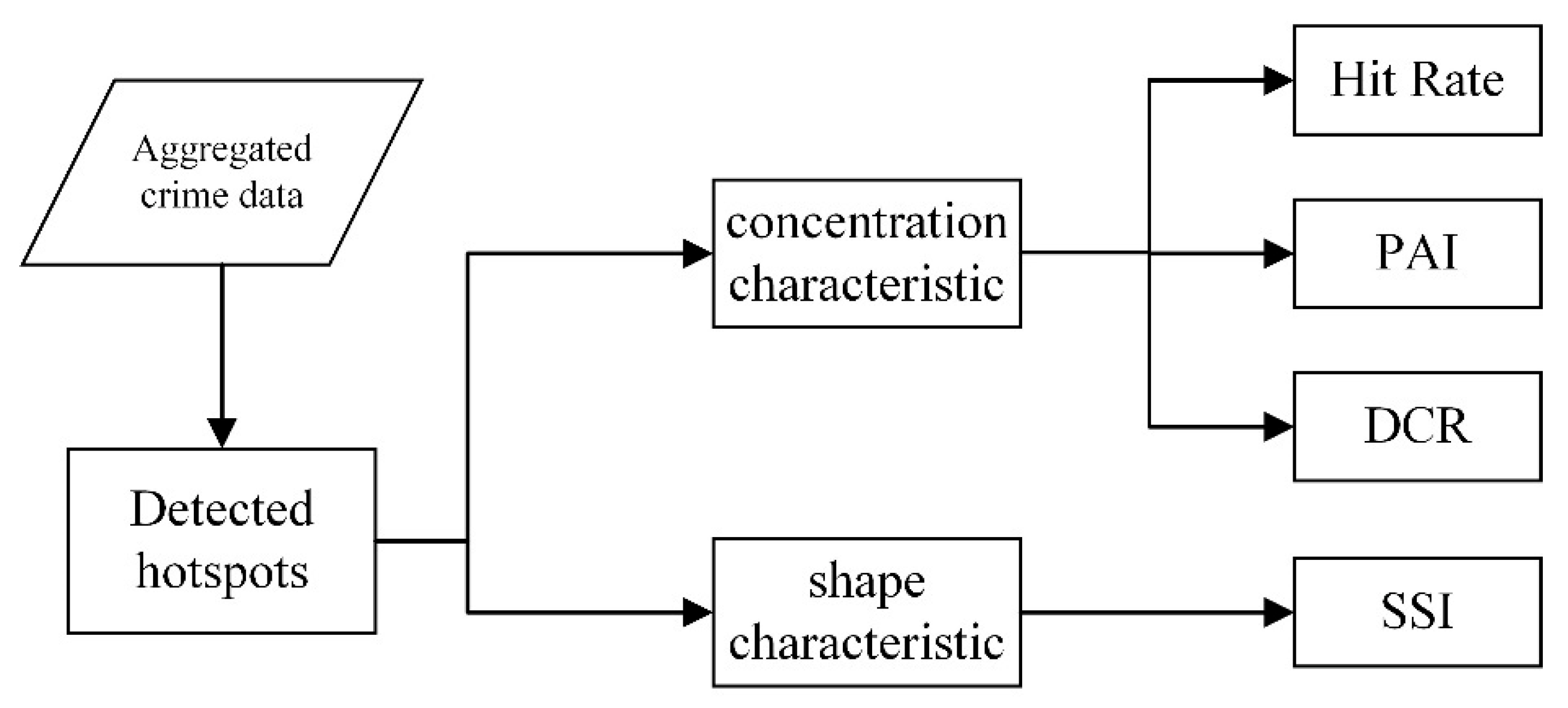
2.2. Framework for Evaluating Performance of Spatial Hotspot Detection
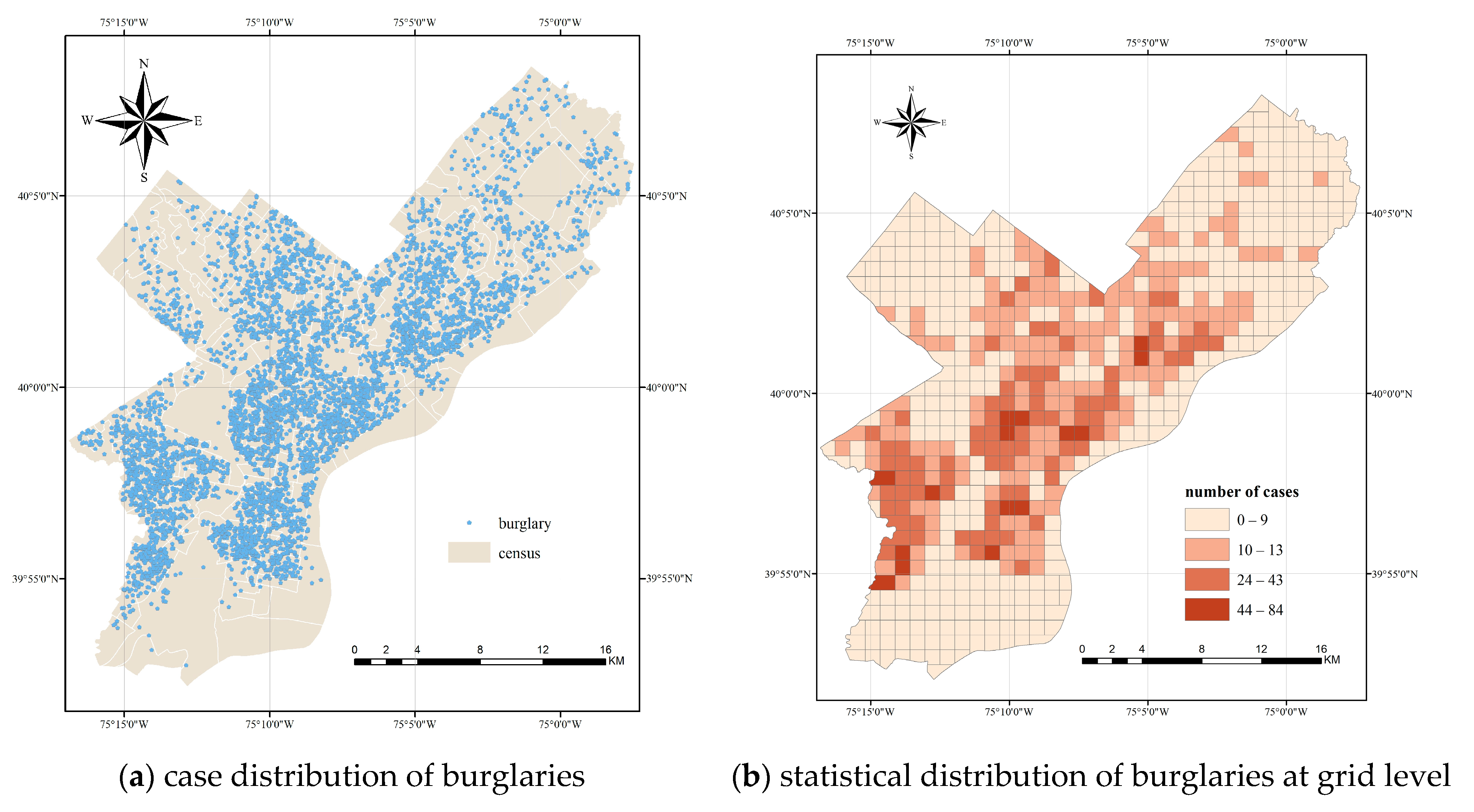
2.3. Study Area and Data
- (1)
- Synthetic data
- (2)
- Real crime data
3. Results
3.1. Experimental Results of Synthetic Data
3.2. Experimental Results of Real Crime Data
4. Discussion
5. Conclusions
Author Contributions
Funding
Institutional Review Board Statement
Informed Consent Statement
Data Availability Statement
Conflicts of Interest
References
- Chainey, S.; Ratcliffe, J.H. GIS and Crime Mapping; John Wiley & Sons: Chichester, UK, 2013. [Google Scholar]
- Shiode, S. Street-level Spatial Scan Statistic and STAC for Analysing Street Crime Concentrations. Trans. GIS 2011, 15, 365–383. [Google Scholar] [CrossRef]
- Telep, C.W.; Mitchell, R.J.; Weisburd, D. How much time should the police spend at crime hot spots? Answers from a police agency directed randomized field trial in Sacramento, California. Justice Q. 2014, 31, 905–933. [Google Scholar] [CrossRef]
- Sherman, L.W.; Weisburd, D. General deterrent effects of police patrol in crime “hot spots”: A randomized, controlled trial. Justice Q. 1995, 12, 625–648. [Google Scholar] [CrossRef]
- Weisburd, D.; Eck, J.E. What can police do to reduce crime, disorder, and fear? Ann. Am. Acad. Political Soc. Sci. 2004, 593, 42–65. [Google Scholar] [CrossRef]
- Craglia, M.; Haining, R.; Signoretta, P. Modelling high-intensity crime areas in English cities. Urban Stud. 2001, 38, 1921–1941. [Google Scholar] [CrossRef]
- Uittenbogaard, A.; Ceccato, V. Space-time clusters of crime in Stockholm, Sweden. Rev. Eur. Stud. 2012, 4, 148. [Google Scholar] [CrossRef]
- Eck, J.E.; Chainey, S.; Cameron, J.G.; Leitner, M.; Wilson, R.E. Mapping Crime: Understanding Hot Spots. Available online: http://www.ncjrs.gov/pdffiles1/nij/209393.pdf (accessed on 10 May 2015).
- Grubesic, T.H. On the application of fuzzy clustering for crime hot spot detection. J. Quant. Criminol. 2006, 22, 77–105. [Google Scholar] [CrossRef]
- Johnson, S.D.; Bowers, K.J. Stable and fluid hotspots of crime: Differentiation and identification. Built Environ. 2008, 34, 32–45. [Google Scholar] [CrossRef]
- Grubesic, T.H.; Murray, A.T. Detecting hot spots using cluster analysis and GIS. In Proceedings of the Fifth Annual International Crime Mapping Research Conference, Dallas, TX, USA, 1–4 December 2001. [Google Scholar]
- Murray, A.T.; Grubesic, T.H. Exploring spatial patterns of crime using non-hierarchical cluster analysis. In Crime Modeling and Mapping Using Geospatial Technologies; Springer: Berlin/Heidelberg, Germany, 2013; pp. 105–124. [Google Scholar]
- Kulldorff, M. A spatial scan statistic. Commun. Stat. Theory Methods 1997, 26, 1481–1496. [Google Scholar] [CrossRef]
- Anselin, L. Local indicators of spatial association—LISA. Geogr. Anal. 1995, 27, 93–115. [Google Scholar] [CrossRef]
- Getis, A.; Ord, J.K. The analysis of spatial association by use of distance statistics. In Perspectives on Spatial Data Analysis; Springer: Berlin/Heidelberg, Germany, 2010; pp. 127–145. [Google Scholar]
- Frazier, A.E.; Bagchi-Sen, S.; Knight, J. The spatio-temporal impacts of demolition land use policy and crime in a shrinking city. Appl. Geogr. 2013, 41, 55–64. [Google Scholar] [CrossRef]
- Baller, R.D.; Anselin, L.; Messner, S.F.; Deane, G.; Hawkins, D.F. Structural covariates of US county homicide rates: Incorporating spatial effects. Criminology 2001, 39, 561–588. [Google Scholar] [CrossRef]
- Xie, Z.; Yan, J. Detecting traffic accident clusters with network kernel density estimation and local spatial statistics: An integrated approach. J. Transp. Geogr. 2013, 31, 64–71. [Google Scholar] [CrossRef]
- Quick, M.; Law, J. Exploring hotspots of drug offences in Toronto: A comparison of four local spatial cluster detection methods. Can. J. Criminol. Crim. Justice 2013, 55, 215–238. [Google Scholar] [CrossRef]
- Wheeler, D.C. A comparison of spatial clustering and cluster detection techniques for childhood leukemia incidence in Ohio, 1996–2003. Int. J. Health Geogr. 2007, 6, 13. [Google Scholar] [CrossRef] [Green Version]
- Lipton, R.; Gruenewald, P. The spatial dynamics of violence and alcohol outlets. J. Stud. Alcohol 2002, 63, 187–195. [Google Scholar] [CrossRef]
- Drawve, G.; Moak, S.C.; Berthelot, E.R. Predictability of gun crimes: A comparison of hot spot and risk terrain modelling techniques. Polic. Soc. 2016, 26, 312–331. [Google Scholar] [CrossRef]
- Bowers, K.J.; Johnson, S.D.; Pease, K. Prospective hot-spotting: The future of crime mapping? Br. J. Criminol. 2004, 44, 641–658. [Google Scholar] [CrossRef]
- Chainey, S.; Tompson, L.; Uhlig, S. The utility of hotspot mapping for predicting spatial patterns of crime. Secur. J. 2008, 21, 4–28. [Google Scholar] [CrossRef]
- Rashidi, P.; Wang, T.; Skidmore, A.; Vrieling, A.; Darvishzadeh, R.; Toxopeus, B.; Ngene, S.; Omondi, P. Spatial and spatiotemporal clustering methods for detecting elephant poaching hotspots. Ecol. Model. 2015, 297, 180–186. [Google Scholar] [CrossRef]
- Hart, T.; Zandbergen, P. Kernel density estimation and hotspot mapping: Examining the influence of interpolation method, grid cell size, and bandwidth on crime forecasting. Polic. Int. J. Police Strateg. Manag. 2014, 37, 305–323. [Google Scholar] [CrossRef]
- Hu, Y.; Wang, F.; Guin, C.; Zhu, H. A spatio-temporal kernel density estimation framework for predictive crime hotspot mapping and evaluation. Appl. Geogr. 2018, 99, 89–97. [Google Scholar] [CrossRef]
- Chainey, S.P. Examining the influence of cell size and bandwidth size on kernel density estimation crime hotspot maps for predicting spatial patterns of crime. Bull. Geogr. Soc. Liege 2013, 60, 7–19. [Google Scholar]
- Grubesic, T.H.; Wei, R.; Murray, A.T. Spatial clustering overview and comparison: Accuracy, sensitivity, and computational expense. Ann. Assoc. Am. Geogr. 2014, 104, 1134–1156. [Google Scholar] [CrossRef]
- Johnson, S.; Bowers, K.J.; Birks, D.; Pease, K. Predictive Mapping: Accuracy for Different Units of Analysis and the role of the Environmental Backcloth. In Putting Crime in Its Place: Units of Analysis in Spatial Crime Research; Springer: New York, NY, USA, 2008; pp. 171–198. [Google Scholar]
- Besag, J.; Newell, J. The detection of clusters in rare diseases. J. R. Stat. Soc. Ser. A (Stat. Soc.) 1991, 154, 143–155. [Google Scholar] [CrossRef]
- Openshaw, S.; Charlton, M.; Wymer, C.; Craft, A. A mark 1 geographical analysis machine for the automated analysis of point data sets. Int. J. Geogr. Inf. Syst. 1987, 1, 335–358. [Google Scholar] [CrossRef]
- Fotheringham, A.S.; Zhan, F.B. A comparison of three exploratory methods for cluster detection in spatial point patterns. Geogr. Anal. 1996, 28, 200–218. [Google Scholar] [CrossRef]
- Aldstadt, J.; Getis, A. Using AMOEBA to create a spatial weights matrix and identify spatial clusters. Geogr. Anal. 2006, 38, 327–343. [Google Scholar] [CrossRef]
- Ceccato, V.; Haining, R. Crime in border regions: The Scandinavian case of Öresund, 1998–2001. Ann. Assoc. Am. Geogr. 2004, 94, 807–826. [Google Scholar]
- Ceccato, V. Homicide in São Paulo, Brazil: Assessing spatial-temporal and weather variations. J. Environ. Psychol. 2005, 25, 307–321. [Google Scholar] [CrossRef]
- Leitner, M.; Helbich, M. The impact of hurricanes on crime: A spatio-temporal analysis in the city of Houston, Texas. Cartogr. Geogr. Inf. Sci. 2011, 38, 213–221. [Google Scholar] [CrossRef]
- O’Loughlin, J.; Witmer, F.D. The localized geographies of violence in the North Caucasus of Russia, 1999–2007. Ann. Assoc. Am. Geogr. 2011, 101, 178–201. [Google Scholar] [CrossRef]
- Ceccato, V.; Uittenbogaard, A.; Bamzar, R. Security in Stockholm’s underground stations: The importance of environmental attributes and context. Secur. J. 2013, 26, 33–59. [Google Scholar] [CrossRef]
- Jung, I.; Kulldorff, M.; Klassen, A.C. A spatial scan statistic for ordinal data. Stat. Med. 2007, 26, 1594–1607. [Google Scholar] [CrossRef]
- Huang, L.; Kulldorff, M.; Gregorio, D. A spatial scan statistic for survival data. Biometrics 2007, 63, 109–118. [Google Scholar] [CrossRef] [Green Version]
- Kulldorff, M.; Huang, L.; Konty, K. A scan statistic for continuous data based on the normal probability model. Int. J. Health Geogr. 2009, 8, 58. [Google Scholar] [CrossRef] [Green Version]
- Jung, I.; Kulldorff, M.; Richard, O.J. A spatial scan statistic for multinomial data. Stat. Med. 2010, 29, 1910–1918. [Google Scholar] [CrossRef] [Green Version]
- Raychaudhuri, S. Introduction to monte carlo simulation. In Proceedings of the 2008 Winter Simulation Conference, Miami, FL, USA, 7–10 December 2008; pp. 91–100. [Google Scholar]
- Malleson, N.; Andresen, M.A. The impact of using social media data in crime rate calculations: Shifting hot spots and changing spatial patterns. Cartogr. Geogr. Inf. Sci. 2015, 42, 112–121. [Google Scholar] [CrossRef]
- Ceccato, V.; Haining, R.; Signoretta, P. Exploring offence statistics in Stockholm City using spatial analysis tools. Ann. Assoc. Am. Geogr. 2002, 92, 29–51. [Google Scholar] [CrossRef] [Green Version]
- Malleson, N.; Andresen, M.A. Exploring the impact of ambient population measures on London crime hotspots. J. Crim. Justice 2016, 46, 52–63. [Google Scholar] [CrossRef] [Green Version]
- Haleem, M.S.; Lee, W.D.; Ellison, M.; Bannister, J. The ’exposed’ population, violent crime in public space and the night-time economy in Manchester, UK. Eur. J. Crim. Policy Res. 2021, 27, 335–352. [Google Scholar] [CrossRef]
- Ratcliffe, J.H.; Taniguchi, T.; Groff, E.R.; Wood, J.D. The Philadelphia foot patrol experiment: A randomized controlled trial of police patrol effectiveness in violent crime hotspots. Criminology 2011, 49, 795–831. [Google Scholar] [CrossRef]
- Andresen, M.A. The ambient population and crime analysis. Prof. Geogr. 2011, 63, 193–212. [Google Scholar] [CrossRef]
- Ristea, A.; Andresen, M.A.; Leitner, M. Using tweets to understand changes in the spatial crime distribution for hockey events in Vancouver. Can. Geogr./Le Géographe Can. 2018, 62, 338–351. [Google Scholar] [CrossRef] [PubMed] [Green Version]
- Morenoff, J.D.; Sampson, R.J.; Raudenbush, S.W. Neighborhood inequality, collective efficacy, and the spatial dynamics of urban violence. Criminology 2001, 39, 517–558. [Google Scholar] [CrossRef]
- Malik, A.; Maciejewski, R.; Collins, T.F.; Ebert, D.S. Visual analytics law enforcement toolkit. In Proceedings of the 2010 IEEE International Conference on Technologies for Homeland Security (HST), Waltham, MA, USA, 8–10 November 2010; pp. 222–228. [Google Scholar]
- Adepeju, M.; Rosser, G.; Cheng, T. Novel evaluation metrics for sparse spatio-temporal point process hotspot predictions-a crime case study. Int. J. Geogr. Inf. Sci. 2016, 30, 2133–2154. [Google Scholar] [CrossRef] [Green Version]
- Hulshoff, R.M. Landscape indices describing a Dutch landscape. Landsc. Ecol. 1995, 10, 101–111. [Google Scholar] [CrossRef]
- Frohn, R.C. Remote Sensing for Landscape Ecology: New Metric Indicators for Monitoring, Modeling, and Assessment of Ecosystems; CRC Press: Boca Raton, FL, USA, 2018. [Google Scholar]
- Bogaert, J.; Myneni, R.B.; Knyazikhin, Y. A mathematical comment on the formulae for the aggregation index and the shape index. Landsc. Ecol. 2002, 17, 87–90. [Google Scholar] [CrossRef]
- Aamodt, G.; Samuelsen, S.O.; Skrondal, A. A simulation study of three methods for detecting disease clusters. Int. J. Health Geogr. 2006, 5, 15. [Google Scholar] [CrossRef] [Green Version]
- Kulldorff, M.; Tango, T.; Park, P.J. Power comparisons for disease clustering tests. Comput. Stat. Data Anal. 2003, 42, 665–684. [Google Scholar] [CrossRef]
- Duque, J.C.; Aldstadt, J.; Velasquez, E.; Franco, J.L.; Betancourt, A. A computationally efficient method for delineating irregularly shaped spatial clusters. J. Geogr. Syst. 2011, 13, 355–372. [Google Scholar] [CrossRef]
- He, Z.; Wang, Z.; Xie, Z.; Wu, L.; Chen, Z. Multiscale analysis of the influence of street built environment on crime occurrence using street-view images. Comput. Environ. Urban Syst. 2022, 97, 101865. [Google Scholar] [CrossRef]
- He, Z.; Deng, M.; Xie, Z.; Wu, L.; Chen, Z.; Pei, T. Discovering the joint influence of urban facilities on crime occurrence using spatial co-location pattern mining. Cities 2020, 99, 102612. [Google Scholar] [CrossRef]
- He, Z.; Xie, Z.; Wu, L.; Tao, L. Discovering significant situational profiles of crime occurrence by modeling complex spatial interactions. Spat. Stat. 2020, 38, 100463. [Google Scholar] [CrossRef]


| Methods | TP + FP | FN + FP | FN | FP | TP | Precision | Recall | |
|---|---|---|---|---|---|---|---|---|
| SaTScan | 320 | 137 | 48 | 89 | 231 | 72.1% | 82.8% | 0.771 |
| Getis–Ord G* | 209 | 80 | 75 | 5 | 204 | 97.6% | 73.1% | 0.836 |
| local Moran’s I | 198 | 81 | 81 | 0 | 198 | 100% | 71% | 0.830 |
| AMOEBA | 286 | 7 | 0 | 7 | 279 | 97.6% | 100% | 0.988 |
| Methods | n | HitRate | AreaRatio | PAI | DCR |
|---|---|---|---|---|---|
| SaTScan | 1857 | 40.5% | 26.67% | 1.52 | 1.87 |
| Getis–Ord G* | 1393 | 30.4% | 17.42% | 1.75 | 2.07 |
| local Moran’s I | 1352 | 29.5% | 16.50% | 1.78 | 2.12 |
| AMOEBA | 1906 | 41.6% | 23.83% | 1.74 | 2.27 |
| Methods | n | HitRate | AreaRatio | PAI | DCR | SSI |
|---|---|---|---|---|---|---|
| SaTScan | 4139 | 59.16% | 28.29% | 2.06 | 3.67 | 0.678 |
| Getis–Ord G* | 2953 | 42.21% | 14.65% | 2.87 | 4.26 | 0.698 |
| local Moran’s I | 2748 | 39.29% | 12.65% | 3.14 | 4.67 | 0.742 |
| AMOEBA | 4120 | 58.89% | 22.33% | 2.60 | 4.99 | 0.787 |
Publisher’s Note: MDPI stays neutral with regard to jurisdictional claims in published maps and institutional affiliations. |
© 2022 by the authors. Licensee MDPI, Basel, Switzerland. This article is an open access article distributed under the terms and conditions of the Creative Commons Attribution (CC BY) license (https://creativecommons.org/licenses/by/4.0/).
Share and Cite
He, Z.; Lai, R.; Wang, Z.; Liu, H.; Deng, M. Comparative Study of Approaches for Detecting Crime Hotspots with Considering Concentration and Shape Characteristics. Int. J. Environ. Res. Public Health 2022, 19, 14350. https://doi.org/10.3390/ijerph192114350
He Z, Lai R, Wang Z, Liu H, Deng M. Comparative Study of Approaches for Detecting Crime Hotspots with Considering Concentration and Shape Characteristics. International Journal of Environmental Research and Public Health. 2022; 19(21):14350. https://doi.org/10.3390/ijerph192114350
Chicago/Turabian StyleHe, Zhanjun, Rongqi Lai, Zhipeng Wang, Huimin Liu, and Min Deng. 2022. "Comparative Study of Approaches for Detecting Crime Hotspots with Considering Concentration and Shape Characteristics" International Journal of Environmental Research and Public Health 19, no. 21: 14350. https://doi.org/10.3390/ijerph192114350
APA StyleHe, Z., Lai, R., Wang, Z., Liu, H., & Deng, M. (2022). Comparative Study of Approaches for Detecting Crime Hotspots with Considering Concentration and Shape Characteristics. International Journal of Environmental Research and Public Health, 19(21), 14350. https://doi.org/10.3390/ijerph192114350