Article

Tracing Sulfate Source and Transformation in the Groundwater of the Linhuan Coal Mining Area, Huaibei Coalfield, China

Anhui Province Engineering Laboratory for Mine Ecological Remediation, School of Resources and Environmental Engineering, Anhui University, Hefei 230601, China
*
Author to whom correspondence should be addressed.
Int. J. Environ. Res. Public Health 2022, 19(21), 14434; https://doi.org/10.3390/ijerph192114434
Submission received: 23 October 2022 / Revised: 30 October 2022 / Accepted: 31 October 2022 / Published: 4 November 2022
(This article belongs to the Special Issue Environmental Behavior and Effects of Pollutants)

Abstract

:
Mining activities cause surface sulfate enrichment, which has negative impacts on human health and ecosystems. These high concentrations of sulfate may enter groundwater through the unsaturated zone (UZ), threatening groundwater quality. Therefore, we combined hydrochemical and dual isotopic analyses of sulfate in surface water, soil water and groundwater with evaluations of the UZ to identify the groundwater sulfate source and transformation in the coal mining area. Soil profile samples were collected near gangue heaps (UZ−1, UZ−2) and the mean sulfate concentrations of the UZ−1 profile and UZ−2 profile were 35.4 mg/L and 69.63 mg/L, respectively. The shallow groundwater sulfate was mainly from dissolution of evaporite, sulfide oxidation and sewage. Different sulfate contaminated areas showed different characteristics of sulfate sources. The sulfate source to groundwater near the coal gangue heaps was sulfide oxidation. The groundwater sulfate near the gangue heaps and industrial park compound contamination area was mainly derived from industrial and domestic sewage and sulfide oxidation. In addition, the role of bacterial sulfate reduction (BSR) in the groundwater was not obvious. This research result is of great significance for promoting the safe mining of coal resources and sustainable utilization of groundwater in the Huaibei coal mining area and other coal mining areas in China.

1. Introduction

Coal is the dominant form of energy in China [1]. The Huaibei coalfields are an important coal base in China, and they have been mined for coal since the 1960s. Sulfate is a typical anion in aqueous environments and is ignored as a contaminant in groundwater. In general, the highest levels of sulfate in groundwater are from natural sources such as the dissolution of minerals (such as gypsum) and rainfall [2,3,4,5]. However, with the intensification of coal mining activities, the aqueous environment of the coalfields has been polluted due to coal gangue accumulation, mine drainage, leachate from tailings heaps, etc. Coal mining activities have become another factor in the increased sulfate load in groundwater. The potential sources of SO42− in coal mining areas include natural sources, such as the dissolution of gypsum, oxidation of sulfides (pyrite) and atmospheric precipitation [6,7,8], and anthropogenic sources, such as discharges of domestic and industrial wastewaters, the use of agricultural fertilizers, and coal mining activities [9,10,11]. Increases in the SO42− concentrations of mining-affected ecosystems can have negative environmental impacts, including acidification and the release of heavy metals and methyl mercury into aquatic systems [12,13]. The concentration of SO42− is limited to below 250 mg/L by the WHO and by the drinking water standards in China. High SO42− concentrations can cause health issues such as diarrhea and gastrointestinal disorders [14,15]. Water contamination with sulfate not only threatens human health and ecological functions, but also affects carbonate weathering and the evolution of the global carbon and nitrogen cycles [16,17,18,19]. It has been reported that the concentration of SO42− in the surface water of the coal mining area was high, over 250 mg/L, and sulfate contamination of the groundwater has also been noted [20,21]. For the utilization and protection of regional water resources, it is of great significance to understand the sources and transformation processes of sulfate under the effect of mining.
The dual isotopes (δ34S−SO42− and δ18O−SO42−) of SO42− have served as powerful tracers to distinguish the sources and migration and transformation processes of sulfate along flow paths [22,23,24,25,26]. The main factors controlling the δ34S−SO42− and δ18O−SO42− values of sulfate include geological and hydrological settings, geographical location, precipitation, and biological activity (bacterial sulfate reduction, BSR). It is worth noting that BSR is the key process in the earth’s sulfur cycle causing significant isotopic fractionation and reducing the sulfate concentrations in closed systems [27,28]. The hydrogeochemical characteristics of formation water can also provide useful information about the evolution of formation water, such as the degree of water-rock interactions and the source of solutes. Therefore, using a combination of a hydrochemical technique and dual isotope approach is an effective way to elucidate the sulfate sources and transformation processes in the hydrological systems [29,30,31].
The unsaturated zone (UZ) links surface water and groundwater and plays an important role in the hydrological cycle [32,33,34]. The UZ is an important site for SO42− recycling and transformation and is also the main route for surface SO42− pollution to enter groundwater [35,36,37]. The groundwater table is low, and the UZ is shallow in the coal mining area. Due to extensive mining activities, sulfate has accumulated in the shallow UZ, posing a potential threat to the shallow groundwater resources. Previous studies have mainly focused on the identification of sulfate sources in surface water, hydrochemical characteristics of karst water, water–rock interaction mechanisms of deep aquifers, water-inrush source identification, etc. [27,38]. For example, Chen et al. [39] revealed the hydrochemical characteristics and spatial–temporal evolution mechanisms of a multiaquifer groundwater system disturbed by mining operations. Chen et al. [21] focused on the comparison of water chemistry and sulfur and oxygen isotopes between natural surface water (river water) and contaminated mine subsidence water and traced the source of sulfate in the river and subsidence water in the mining area. The above research has laid a solid foundation for this study. However, the source and transformation of sulfate in groundwater of the study area have not been systematically studied, and local investigations cannot provide sufficient information about the sulfur cycle. This study focused on the surface water, groundwater and soil water in the UZ of the Linhuan mining area in Huaibei. The main research objectives were (1) to determine the content and distribution characteristics of sulfate in the surface water, soil water and groundwater of the study area; (2) to reveal the sources of sulfate in the UZ; and (3) to determine the transformation characteristics and sources of sulfate in local groundwater. The findings provide a reference for developing effective strategies to reduce the SO42− inputs associated with mining activities and to determine appropriate measures to balance economic development with water quality protection in coal mining areas.

2. Materials and Methods
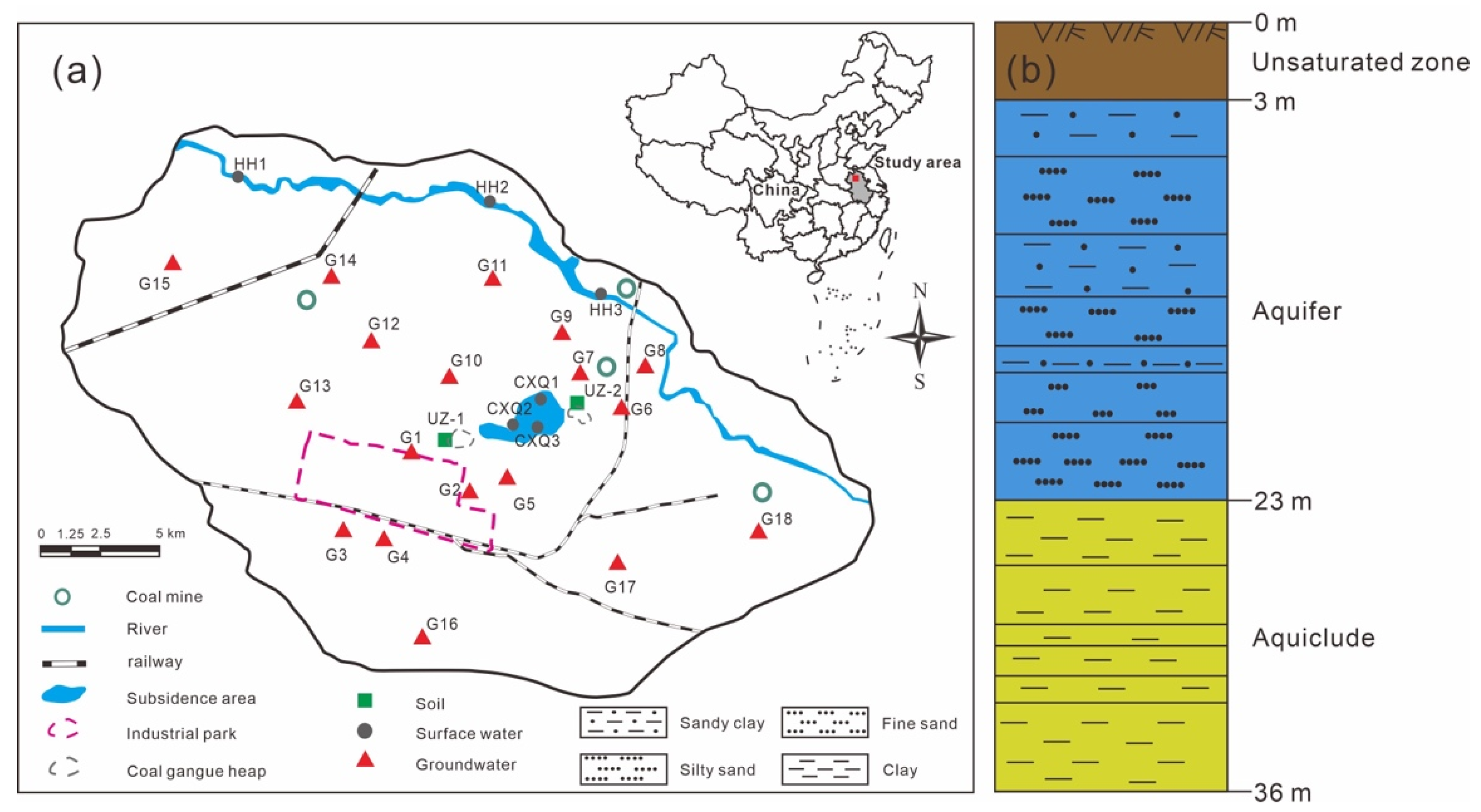
2.1. Study Sites

The Linhuan coal mining area, with a history of nearly 30 years of coal mining, is situated in Huaibei, Anhui Province, China. It is approximately 30.0 km east of Suzhou and 40.0 km north of Huaibei, covering a total area of approximately 1750 km2. The study area is subject to a semihumid climate and is in a warm belt with seasonal monsoons and four distinct seasons, and the annual average temperature is 14.5 °C. The annual average precipitation is 830 mm, most of which is concentrated in July and August. Moreover, the annual average evaporation is 1045.2 mm.
There are 4 mines in the mining area, all of which are large underground mines. The industrial park, located in the southern part of the study area, includes coking plants, coal preparation plants, coal-fired power plants, cement plants, etc. Residential areas are present outside the industrial park and subsidence area. The constructions and mining activities at the coal mining area have already caused adverse environmental effects, such as large numbers of coal gangue heaps and large areas of water accumulation in the subsidence area. The surface water in the study area mainly consists of a river and subsidence area water. The main river is the Huihe River, which is a seasonal river flowing from northwest to southeast. The upper reaches of the Huihe River are the main source of Quaternary sediment detrital materials, and these sediments are rich in gypsum and mirabilite in parts of the upper reaches [40]. The subsidence area water is concentrated north of the Linhuan industrial park and south of the Huihe River. Two coal gangue heaps are located on the eastern and western sides of the subsidence area. The cumulative area of the subsidence area is approximately 175.46 hm2, with an average water depth of 3.45 m and a maximum depth of 10.0 m (Figure 1a).
The study area is a flat plain, in which the elevation ranges from +23 to +28 m and gradually decreases from northwest to southeast. The component strata (from bottom to top) consist of Ordovician, Carboniferous, Permian, Paleogene, Neogene and Quaternary strata. The coal gangue is mostly composed of sandstone, mudstone, sandy shale and trace amounts of low−S, low−pyrite coal in Carboniferous and Permian strata [41]. There are relatively thick unconsolidated Neogene and Quaternary strata in the study area, with thicknesses of 186–291 m (mean 238 m). As shown in Figure 1b, the unsaturated zone is at a depth of 0–3 m. According to the lithologic assemblages and comparisons with regional hydrogeological profiles, four aquifer groups and three aquiclude groups can be distinguished. The shallow groundwater is located in the first aquifer at the top (3–23 m depth), with a thickness of 20 m and a water table depth of 3–5 m, which is the main water source for anthropic uses and irrigation in the study area. The first aquiclude is at a depth of 23–36 m, with a thickness of 5–30 m (mean 13 m). Fine sand and silty sand with 2–3 layers of thin sandy clay are the main components of the aquifer.

2.2. Sampling and Sample Preparation

A sampling campaign was launched in December 2021. The samples included 6 surface water samples, 18 groundwater samples and 2 soil profiles. The distribution of sampling points was shown in Figure 1a. The depth of shallow groundwater is different in time, and the variation amplitude is generally between 1 and 3 m. Therefore, two soil profile samples (UZ−1 and UZ−2) of the unsaturated zone at a 2 m depth were collected near the coal gangue heaps 500 m from the subsidence area. We collected soil profile samples with a soil sampling drill, and 2000 g of bulk sample were collected at intervals of 0.4 m at 0–2 m. All soil samples were immediately sealed in polyethylene bags after collection, dried, crushed and passed through a 0.15 mm sieve until concentration and isotopic analyses of water-soluble sulfate.
The Huihe River and subsidence area water were selected for surface water sampling. The shallow underground water samples were drilled in the industrial park (G1–G4) and self-provided wells by residents around the mining area (G5–G18). Shallow groundwater samples were provided by residents from wells around the mining area, with depths of less than 10 m. All water samples were collected in high−density polyethylene samplers, transported to the laboratory and then filtered with 0.45 μm membranes. The samples designated for the cation test were acidified to pH < 2 by HNO3. Each water sample was refrigerated at 4 °C for further hydrochemical and isotopic analyses.

2.3. Hydrochemical and Isotopic Analyses

The basic physical and chemical parameters of the water samples, including electrical conductivity (EC), pH, dissolved oxygen (DO) and temperature (T), were measured in situ using a pH meter (WTW−PH3110, WTW, Munich, Germany) and a portable water quality meter (WTWoxi315i, WTW, Munich, Germany). The samples were analyzed for anions (SO42− and Cl) using ion chromatography (DIONEX, model ICS−1500, Dell, Inc., TX, USA) with an analytical precision of 0.01 mg/L. To obtain the water-soluble sulfate concentration of the soil water, 50 mL of deionized water were added to 5 g of soil and extracted for 6 h [42]. The supernatant solution was filtered through 0.22 μm membranes. The SO42− concentration of the soil water was analyzed by ion chromatography. The anionic standard was according to Chinese Environmental Protection Standard HJ/T 84–2001. The samples were analyzed for cations (K+, Na+, Ca2+, Mg2+ and Fe) using ICP−AES (IRIS Intrepid II XSP, Thermo Fisher Scientific, Waltham, MA, USA) with 0.01 mg/L testing accuracy. The standards (GSB−1738, GSB−1736, GSB−1735 and GSB−1720) were obtained from the National Standards Center at a concentration of 1.0 mg/L. The cations were measured in accordance with the Chinese Environmental Protection Standard HJ/776−2015. The content of HCO3 was determined by double-indicator titration. Phenolphthalein, methyl red and a standard solution of hydrochloric acid (0.05 mol·L−1) were prepared. The phenolphthalein indicator was added to the water sample and titrated with standard acid until colorless. The methyl red indicator was added and titrated again with standard acid until the solution turned orange-red. The content of HCO3 was determined by two doses of standard acid. Each sample was titrated three times, and the control error was less than 5%. The mass concentration of total dissolved solids (TDS) was calculated by subtracting the 1/2HCO3 mass concentration from the sum of the mass concentrations of the anions and cations. The saturation index of minerals in water samples was calculated using PHREEQC. In terms of data quality, to ensure accuracy, data points with an error of more than 5% were excluded from the anion-cation balance analysis.
For the δ34S−SO42− and δ18O−SO42− analyses of water samples, the filtered samples were acidified to pH < 2 by distilled 6 mol/L HCl, and the SO42− in the acidified samples was precipitated by the addition of 10% BaCl2 solutions. Then, the BaSO4 solutions were boiled in an electric furnace, and the precipitates were filtered through 0.22 μm membranes. The BaSO4 samples were ultimately obtained after the precipitates were dried in a muffle furnace at 850 °C for 2 h. For soil profile samples, 1000 g soil samples were ground into powder (100 mesh) and then extracted with 3000 mL of deionized water for 24 h. The extracted samples were filtered through 0.22 μm membranes and then treated in the same manner as the water samples described above for δ34S−SO42− and δ18O−SO42− analyses.
The sulfur and oxygen isotopes of all samples were analyzed using an elemental analyzer−stable isotopic ratio mass spectrometer (Thermo Fisher, Delta v Plus, Waltham, MA, USA). The BaSO4−S samples were converted to SO2 at 1000 °C, and the 34S/32S ratios of BaSO4 were measured for SO2 gas. BaSO4−O was introduced to C at temperatures between 1350 and 1500 °C and was quantitatively converted to CO. The 18O/16O ratios of BaSO4 were analyzed from the generated CO gas. The accuracy of sulfur and oxygen isotopic analyses was checked periodically by analyses of international reference barium sulfates (NBS127) and International Atomic Energy Agency materials (IAEA−S05, IAEA−S06). The analytical precision values of δ34S−SO42− and δ18O−SO42− were better than ±0.2% and ±0.3‰, respectively. The stable isotopic compositions of sulfur and oxygen were reported as δ values (‰), the isotopic ratio in delta relative to standards:
δ sample ( ) = [ ( R sample R standard ) / R standard ] × 1000
where R is the isotopic ratio of sulfur or oxygen (34S/32S, 18O/16O) and Rsample and Rstandard are the isotopic ratios of the sample and standard, respectively. The international standards for sulfur and oxygen are V−CDT and V−SMOW, respectively.

3. Results and Discussion

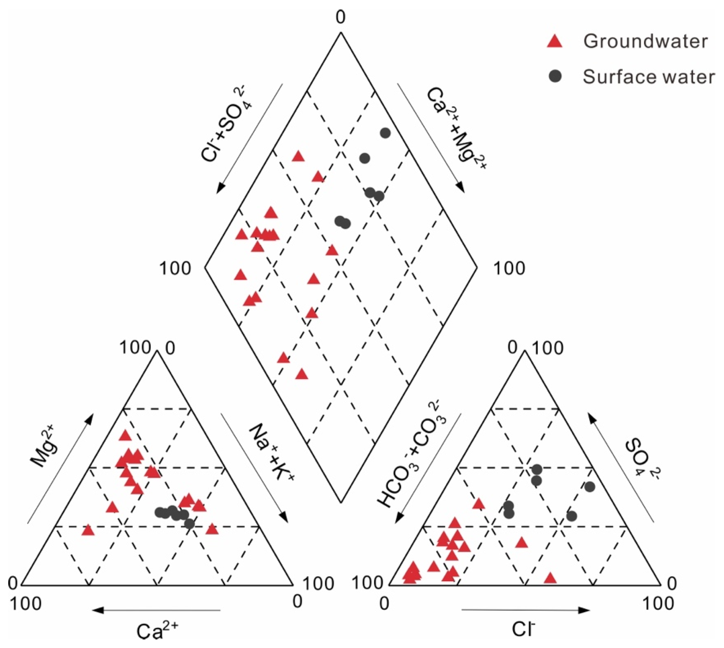
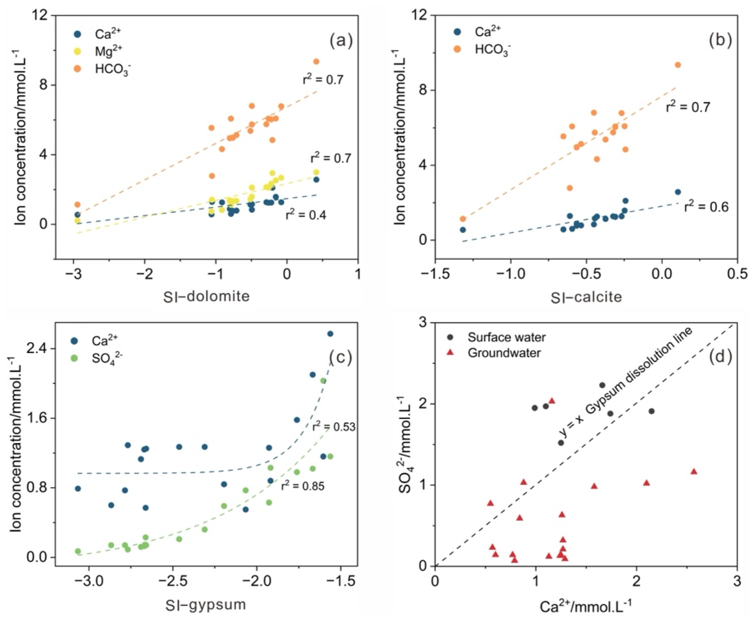
3.1. Hydrogeochemical Processes

The hydrochemical compositions of the surface water and groundwater in the coal mining area are listed in Table 1. The surface water and groundwater were generally weakly alkaline and had low TDS and high Ec. The Huihe River water, subsidence area water and groundwater were in an aerobic environment in the catchment. The piper diagram can reflect the main ion compositions and chemical characteristics of the water. As shown in Figure 2, two hydrochemical types of water samples were classified: (a) Na·Ca−Cl·SO4 for surface water and (b) Ca·Mg−HCO3 for groundwater. Most groundwater was different from river water and subsidence area water in hydrochemical composition.
Hydrochemical composition can provide useful information about water hydrogeochemical processes, such as the origin of solutes and the extent of water−rock interactions [43,44]. Ion ratio analysis has been widely used to analyze the hydrochemical compositions. In Figure 3a,b, the main groundwater ions were highly correlated with the carbonate SI (SI−dolomite, SI−calcite), indicating that Ca2+, Mg2+ and HCO3 in groundwater were mainly derived from carbonate mineral dissolution. The SI−gypsum in groundwater samples was less than 0, ranging from −1.6 to −3.1 with an average of −2.3, indicating that gypsum was always dissolved along the flow path. Figure 3c showed the relationship between Ca2+, SO42− and SI−gypsum. SI−gypsum had a higher association with SO42− (r2 = 0.85) than Ca2+ (r2 = 0.5), which proved that gypsum could dissolve and release SO42−. The weak correlation between Ca2+ and SI−gypsum was mainly due to the dissolution of carbonate and cation exchange. The ideal molar ratio of the major ions of gypsum (CaSO4·2H2O) should be 1. In Figure 3d, the concentration of Ca2+ in most groundwater samples from the Linhuan mining area was higher than that of SO42−, which further verified that the dissolution of carbonate minerals was the dominant factor in hydrogeochemical processes in this area. The concentration of SO42− was higher than that of Ca2+ in the other samples, which may be due to the existence of cation exchange in addition to gypsum dissolution.

3.2. Sulfate Distributions in the Surface Water, UZ and Groundwater

The SO42− concentrations of surface water, soil profiles, and groundwater are shown in Table 2 and Figure 4. Chen et al. [45] found that the mean SO42− concentration was 386.7 mg/L in the rivers of the Huaibei coalfield between 2015 and 2017. In contrast, the mean SO42− concentration in the surface water was slightly lower at the present site, and the temporal variation in SO42− in the surface water was large. The sulfate concentration of the unconsolidated aquifer varied only slightly [39]. The sulfate concentrations of G2 (98.85 mg/L), G3 (97.67 mg/L) and G13 (111.53 mg/L) were higher than those of other groundwater samples, as these samples were affected by industrial wastewater and domestic sewage from the industrial park. Sampling point G6 (195.13 mg/L) had the highest sulfate concentration, mainly due to the weathering and leaching of the gangue heaps and dissolution of evaporite. The SO42− concentrations of the soil profiles (UZ−1 and UZ−2) increased slightly with soil depth to reach maximum values at 200 cm (Figure 4). The uppermost part of the Cenozoic section is recharged directly by atmospheric precipitation. In addition, the upper stratum has favorable factors, such as good sorting and small compactness, so the runoff conditions are good, and elements can easily migrate. Leaching results in a higher sulfate concentration in the UZ with increasing depth. The SO42− concentration (water−soluble sulfate and adsorbed sulfate) of the soil solution in the Linhuan mining area ranged from 11.08 to 59.18 mg/L (mean 25.38 mg/L) in 2019 [46]. Compared with the previous data, there was a distinct SO42− enrichment phenomenon in the UZ−1 profile and UZ−2 profile. The SO42− concentration of the UZ can be affected by seasonal variations, fertilization and organic sulfur mineralization, as well as by atmospheric deposition and coal gangue accumulation [47].

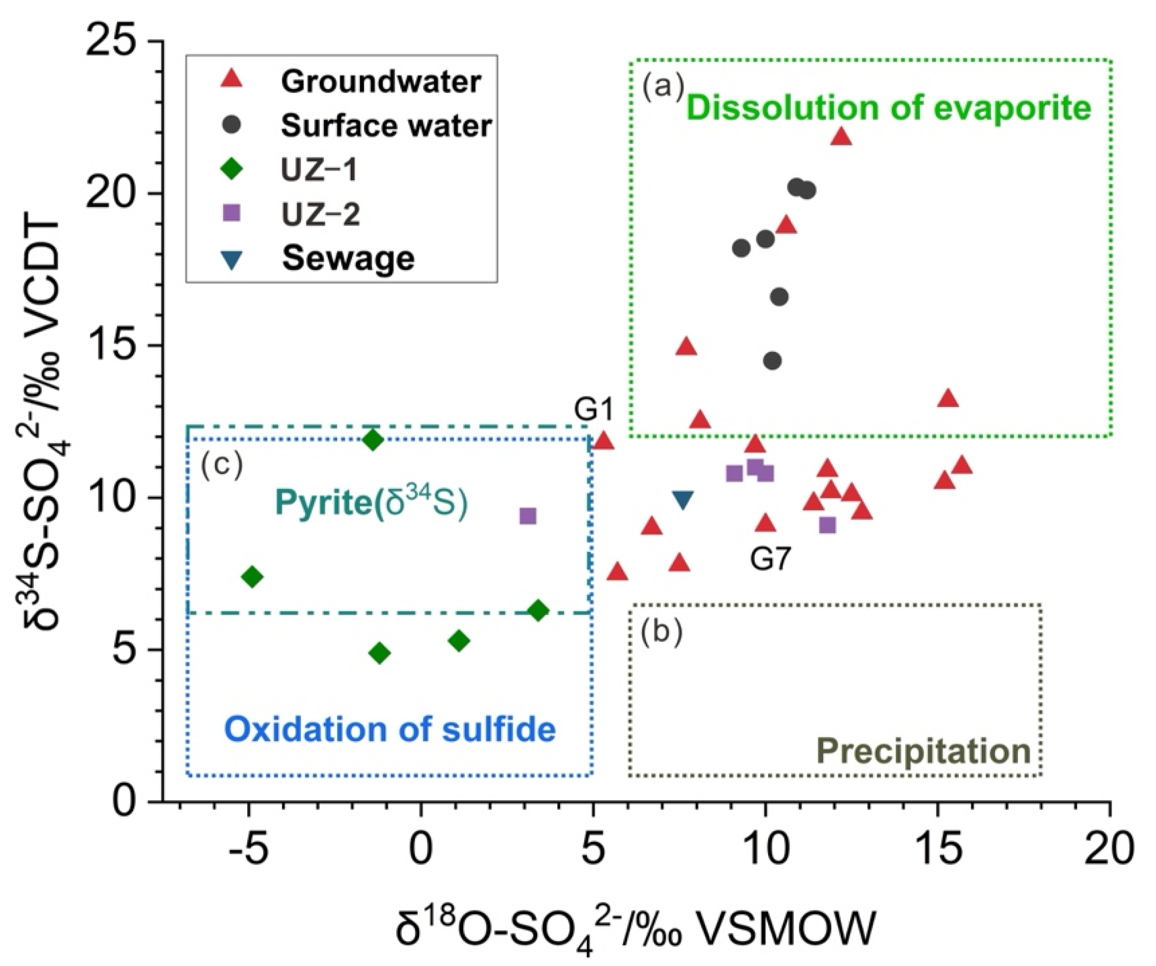
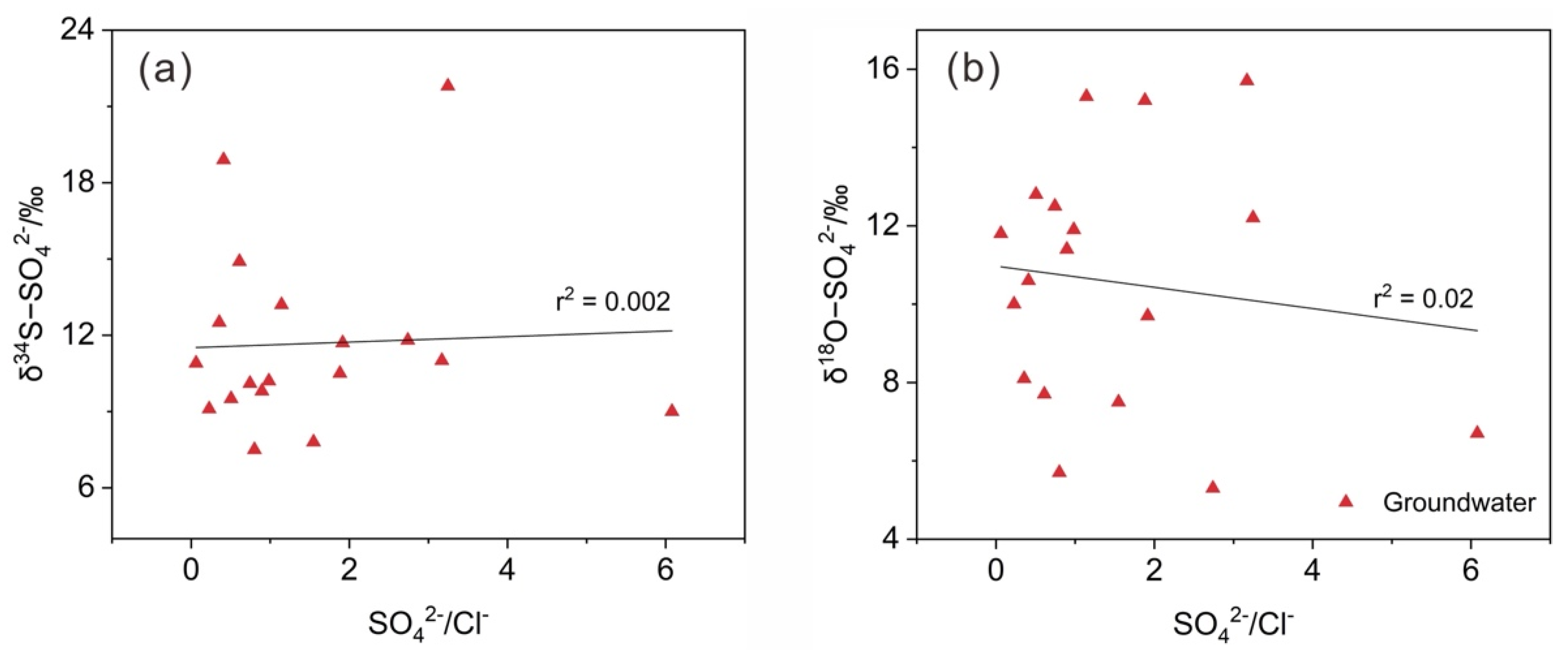
3.3. Sulfate Sources in the Groundwater

In coal mining areas, sulfate can originate from various potential sources, including natural sources, such as atmospheric precipitation, dissolution of evaporite and oxidation of sulfide, and anthropogenic sources, such as sewage and mine drainage [48,49,50,51,52,53,54]. The δ34S−SO42− and δ18O−SO42− values of the surface water ranged from +14.5 to +20.2‰ (mean +18.0‰) and +9.3 to +11.2‰ (mean +10.3‰), respectively. The δ34S−SO42− and δ18O−SO42− values of the groundwater ranged from +7.5 to +21.8‰ (mean +11.7‰) and +5.3 to +15.7‰ (mean +10.6‰), respectively (Table 2).
Atmospheric precipitation is the recharge source for surface water and groundwater in the study area. Atmospheric precipitation usually contains a low concentration of SO42− that can be transported to surface water and aquifers during recharge and runoff processes [55]. The typical δ34S−SO42− and δ18O−SO42− values in precipitation ranged from −5‰ to +6‰ and +6‰ to +18‰, respectively [56]. The δ34S−SO42− and δ18O−SO42− values of precipitation in the study area ranged from +6.3 to +8.7‰ (mean +7.2‰) and from +9.2 to +11.5‰ (mean +10.2‰), respectively [40], which were essentially consistent with the typical results of Li et al. [56]. As shown in Figure 5, the δ34S−SO42− and δ18O−SO42− values of the surface water and groundwater samples did not fall within the range of atmospheric precipitation. Additionally, the SO42− concentration in the precipitation (13.85 mg/L) was much lower than the mean SO42− concentration of the surface water (183.5 mg/L) and groundwater (50.28 mg/L). Consequently, sulfate in atmospheric precipitation cannot be the primary source that provided sulfate with low δ34S values to the surface water and groundwater.
Sewage is another important source for sulfate contamination in the local groundwater [58,59]. The coal mining area covers town and suburban areas. Most of the groundwater samples were collected from residential wells in villages, and a few were taken from wells drilled near industrial park areas. Sewage (e.g., domestic wastewater and manure) from these wells was not systematically treated and therefore continuously infiltrated into shallow aquifers through Cenozoic faults and unsaturated zones. Zhang et al. [8] collected and measured sewage in the North China Plain, and the mean values of δ34S−SO42− and δ18O−SO42− were 10‰ and 7.6‰, respectively. The δ34S−SO42− and δ18O−SO42− values of some of the groundwater samples were close to the range of sewage (Figure 5), which also confirmed the important contribution of sewage to groundwater sulfate.
The dissolution of evaporite can affect SO42− concentrations in surface water and groundwater and enrich isotopic compositions [60,61]. Previous studies have shown that a large number of gypsums were present in the strata of the study area [41]. The coal mining activities damaged the bottom plate of aquifers, which led to linkages between aquifer systems and decreases in the water levels. The above process may enhance the leaching of gypsum mineral in the unsaturated zone during the recharge process, resulting in an increase in SO42− content in the local groundwater and surface water. As seen in Figure 4c, the SI−gypsum was less than 0 and linearly related to the sulfate content of groundwater. Gypsum was always in a dissolved condition and released SO42−. The typical ranges of δ34S−SO42− and δ18O−SO42− for the dissolution of evaporites are between +12 and +35‰ and +6 and +20‰, respectively [56]. Figure 5 showed that all surface water samples had high δ34S−SO42− and δ18O−SO42− values, which were within the range for the dissolution of evaporite. Consequently, evaporite dissolution contributed greatly to the SO42− present in the surface water, which was consistent with the results of Chen et al. [21] in the study area. Evaporite dissolution also contributed to sulfate in the groundwater. The δ34S−SO42− and δ18O−SO42− values of approximately 28% for the groundwater samples were within the range (Figure 5), and the δ34S−SO42− and δ18O−SO42− values of the remaining groundwater samples were lower than those from the dissolution of evaporites. The evaporite dissolution contribution to surface water sulfate was significantly higher than that to groundwater.

3.4. Sulfate Sources in the UZ

Mining activities have resulted in large quantities of coal gangue and large areas of subsidence area water. Sulfate from the sulfide oxidation of coal gangue and subsidence area water may penetrate into groundwater through the unsaturated zone. The sulfide minerals in coal gangue are mainly found in the form of pyrite [62,63]. The environment caused by the damage of strata by mining activities is favorable for the oxidation of sulfides (pyrite) in coal gangue. Sulfide oxidation usually results in minimal S isotopic fractionation [64,65], basically preserving the original isotopic composition of the sulfide minerals. However, the oxygen in water and the atmosphere participates in sulfide oxidation in different proportions, resulting in the extremely complex behavior of δ18O−SO42− [66]. In Figure 5, the δ34S−SO42− values of most UZ samples were close to the δ34S−SO42− range (+6.3‰~+13.5‰, mean 9.9‰) of the precursor sulfide minerals (pyrite) in the coal mine area, as reported by Chen et al. [21], indicating that the δ34S−SO42− signatures resulted from the oxidation of sulfide. The mean pyrite δ34S−SO42− value (9.9‰) of the gangue samples collected in the Linhuan mining area by Chen et al. [21] and δ34S−SO42- and δ18O−SO42−- values of the soil profiles (UZ−1 and UZ−2) collected near the gangue heaps and groundwater sampling points (G1 and G7) closest to the profiles were used to reveal the migration process of sulfate in the UZ and sulfate sources in the groundwater (Figure 6). As shown in Figure 6b, the δ34S−SO42− values of the UZ−2 profile and groundwater sampling point G7 were very similar to the average δ34S−SO42− value of pyrite in the coal gangue. Meanwhile, the δ34S−SO42− values formed a narrow range from +9.1‰ to +11.0‰, and the SO42− content showed an increasing trend with increasing depth of the profile. Figure 6a shows that the variation characteristics of δ34S−SO42− values in the UZ−1 profile at depths of 40−160 cm were similar to those of the UZ−2 profile. This phenomenon in the UZ profiles indicated that oxidation of pyrite occurred in the coal gangue and that the resulting SO42− vertically migrated in the UZ. Yang et al. [46] found that the soil pH value of the subsidence area in Linhuan was generally low, and most of it was under acidic conditions. The soil near the gangue heaps showed higher levels of organic matter and sulfate content than the soil far away from the gangue heaps. Jiang et al. [67] also found that the concentrations of Fe ions in the shallow groundwater near gangue heaps in the mining area were higher than those in other areas. The higher Fe level may be due to the pyrite oxidation of the coal gangue. These studies further indicated that pyrite oxidation was the source of sulfate in groundwater near gangue heaps.
At the depth of 160–200 cm, the δ34S−SO42− values in the UZ−1 profile increased from +6.3‰ to +11.9‰, and the δ34S−SO42− value of groundwater sampling site G1 was close to the δ34S−SO42− in the UZ−1 profile (Figure 6a), which may be due to the mixing of sulfate from pyrite oxidation with sulfate from sewage. The mean value of δ34S−SO42− and δ18O−SO42− in sewage in the North China Plain was 10‰ and 7.6‰, respectively [8]. The mean value of δ34S−SO42− in sewage was higher than that of the dissolved sulfate in the UZ−1 profile (+7.2‰). The mixing of sewage with high δ34S−SO42− values increased the δ34S−SO42− values at the bottom of the UZ−1 profile (160–200 cm). Groundwater sampling point G1 was taken from wells drilled near the industrial park. The concentrations of Cd in the shallow groundwater near the industrial park were higher than those in other areas [67], indicating that the groundwater was contaminated with industrial and domestic sewage. The δ34S−SO42− and δ18O−SO42− values of the subsidence area water (CXQ1−CXQ3) ranged from +16.6‰ to +20.2‰ and +10.4‰ to +11.2‰, respectively, and the mean sulfate concentration was 174.30 mg/L. The δ34S−SO42− and δ18O−SO42− values of the subsidence area water were within the range of gypsum dissolution (Figure 5). The high concentration of SO42− in the subsidence area was mainly from gypsum dissolution, which was supported by Chen et al. [21]. The bottom of the subsidence area water and the Huihe River are composed of clay, sandy clay and silty clay with weak water permeability [68]. Therefore, the subsidence water had little effect on the shallow groundwater.

3.5. Biogeochemical Processes of Sulfate

BSR is a biogeochemical process. Under anaerobic conditions, sulfate is decomposed by the BSR reaction and is eventually reduced to sulfide as the end product [69,70]. The chemical equation is as follows:
S O 4 2 - + 2 C H 2 O = H 2 S + 2 H C O 3
Certain transitions occur in the sulfur and oxygen isotopic ratios of sulfate during the BSR process. In the early stages of BSR, the values of both δ34S−SO42−and δ18O−SO42− change rapidly. However, with the consumption of sulfate, the δ34S−SO42− value continues to increase, and the δ18O−SO42− value of the remaining sulfate may approach a constant value, resulting in the enrichment of 34S in the remaining sulfate [71,72,73,74].
As seen in Figure 7, no significant trend was observed between the δ34S−SO42− and δ18O−SO42− values and SO42−/Cl in the groundwater. Additionally, the mean value of DO in the groundwater was 4.35 mg/L, which also verified that the redox conditions were insufficient to achieve the reduction of SO42− [75]. All these results confirmed that BSR did not significantly change the original isotopic composition of the sulfate sources in the groundwater.

4. Conclusions

A tracer study using chemical and isotopic fingerprints was conducted to illuminate the source and transformation of sulfate in groundwater in the coal mining area.
(1)
The results of sulfate isotopes showed that SO42− in the shallow groundwater was mainly derived from the natural dissolution of evaporite, oxidation of sulfide and sewage.
(2)
The oxidation of sulfide was sulfate source to groundwater near the gangue heaps. The groundwater sulfate near the gangue heaps and industrial park compound contamination area was mainly affected by oxidation of sulfide and industrial and domestic sewage.
(3)
During the process, BSR did not affect the sulfate isotopic composition of groundwater.
Sewage and coal gangue, which are produced by human activities and mining, respectively, are important factors leading to SO42− contamination in the regional groundwater. Therefore, the local government should improve domestic sewage treatment infrastructure and treat coal gangue heaps in a timely manner to prevent SO42− from polluting groundwater and surface water.

Author Contributions

Conceptualization and writing—original draft preparation, L.C. and C.J.; methodology: L.C. and C.J.; investigation, C.J.; software, L.C.; writing—review and editing, C.L. and L.Z. All authors have read and agreed to the published version of the manuscript.

Funding

This research was funded by the Natural Science Foundation of the Department of Education of Anhui Province (KJ2021A0085). The fund provider is Chunlu Jiang.

Institutional Review Board Statement

Not applicable.

Informed Consent Statement

Not applicable.

Data Availability Statement

Not applicable.

Acknowledgments

The authors gratefully acknowledge the editor and anonymous reviewers for their valuable comments on this manuscript. The authors also appreciate the financial support from the organization.

Conflicts of Interest

The authors declare no conflict of interest. The founding sponsor had no role in the design of the study; in the collection, analyses, or interpretation of data; in the writing of the manuscript; or in the decision to publish the results.

References

  1. Liu, B.J.; Wang, J.Y.; He, H.T.; Mishra, V.; Li, Y.H.; Wang, J.X.; Zhao, C.L. Geochemistry of Carboniferous coals from the Laoyaogou mine, Ningwu coalfield, Shanxi Province, northern China: Emphasis on the enrichment of valuable elements. Fuel 2020, 279, 118414. [Google Scholar] [CrossRef]
  2. Fernando, W.A.M.; Ilankoon, I.M.S.K.; Syed, T.H.; Yellishetty, M. Challenges and opportunities in the removal of sulphate ions in contaminated mine water: A review. Miner. Eng. 2018, 117, 74–90. [Google Scholar] [CrossRef]
  3. Galhardi, J.A.; Bonotto, D.M. Hydrogeochemical features of surface water and groundwater contaminated with acid mine drainage (AMD) in coal mining areas: A case study in southern Brazil. Environ. Sci. Pollut. Res. 2016, 23, 18911–18927. [Google Scholar] [CrossRef] [PubMed] [Green Version]
  4. Han, G.; Wen, S.M.; Wang, H.; Feng, Q.C. Sulfidization regulation of cuprite by pre-oxidation using sodium hypochlorite as an oxidant. Int. J. Min. Sci. Technol. 2021, 31, 1117–1128. [Google Scholar] [CrossRef]
  5. Zhang, Q.; Wen, S.M.; Feng, Q.C.; Wang, H. Enhanced sulfidization of azurite surfaces by ammonium phosphate and its effect on flotation. Int. J. Miner. Metall. Mater. 2022, 29, 1150–1160. [Google Scholar] [CrossRef]
  6. Relph, K.E.; Stevenson, E.I.; Turchyn, A.V.; Antler, G.; Bickle, M.J.; Baronas, J.J.; Darby, S.E.; Parsons, D.R.; Tipper, E.T. Partitioning riverine sulfate sources using oxygen and sulfur isotopes: Implications for carbon budgets of large rivers. Earth Planet Sci. Lett. 2021, 567, 116957. [Google Scholar] [CrossRef]
  7. Liu, J.K.; Han, G.L. Major ions and δ34S (SO4) in Jiulongjiang River water: Investigating the relationships between natural chemical weathering and human perturbations. Sci. Total Environ. 2020, 724, 138208. [Google Scholar] [CrossRef]
  8. Zhang, D.; Li, X.D.; Zhao, Z.Q.; Liu, C.Q. Using dual isotopic data to track the sources and behaviors of dissolved sulfate in the western North China plain. Appl. Geochem. 2015, 52, 43–56. [Google Scholar] [CrossRef]
  9. Kim, D.M.; Oh, Y.S.; Lee, J.S. δ34S and δ18O of sulfates and Zn/Cd ratios reveal the cause of soil and groundwater contamination in metalliferous mining areas. J. Geochem. Explor. 2020, 209, 106437. [Google Scholar] [CrossRef]
  10. Killingsworth, B.A.; Bao, H.M. Significant Human Impact on the Flux and delta S-34 of Sulfate from the Largest River in North America. Environ. Sci. Technol. 2015, 49, 4851–4860. [Google Scholar] [CrossRef]
  11. Gammons, C.H.; Brown, A.; Poulson, S.R.; Henderson, T.H. Using stable isotopes (S, O) of sulfate to track local contamination of the Madison karst aquifer, Montana, from abandoned coal mine drainage. Appl. Geochem. 2013, 31, 228–238. [Google Scholar] [CrossRef]
  12. Willacker, J.J.; Eagles-Smith, C.A.; Ackerman, J.T. Mercury bioaccumulation in estuarine fishes: Novel insights from sulfur stable isotopes. Environ. Sci. Technol. 2017, 51, 2131–2139. [Google Scholar] [CrossRef] [PubMed]
  13. Man, K.; Ma, Z.M.; Xu, X.J. Research on the mechanism of sulfate pollution of groundwater in Jiaozuo area. Appl. Mech. Mater. 2014, 665, 436–439. [Google Scholar] [CrossRef]
  14. Sun, J.; Takahashi, Y.; Strosnider, W.H.J.; Kogure, T.; Wu, P.; Cao, X.X. Tracing and quantifying contributions of end members to karst water at a coalfield in southwest China. Chemosphere 2019, 234, 777–788. [Google Scholar] [CrossRef]
  15. Geurts, J.J.M.; Sarneel, J.M.; Willers, B.J.C.; Roelofs, J.G.M.; Verhoeven, J.T.A.; Lamers, L.P.M. Interacting effects of sulphate pollution, sulphide toxicity and eutrophication on vegetation development in fens: A mesocosm experiment. Environ. Pollut. 2009, 157, 2072–2081. [Google Scholar] [CrossRef]
  16. Xu, S.; Li, S.L.; Su, J.; Yue, F.J.; Zhong, J.; Chen, S. Oxidation of pyrite and reducing nitrogen fertilizer enhanced the carbon cycle by driving terrestrial chemical weathering. Sci. Total Environ. 2021, 768, 144343. [Google Scholar] [CrossRef]
  17. Zhang, H.T.; Xu, G.Q.; Zhan, H.B.; Chen, X.Q.; Liu, M.C.; Wang, M.H. Identification of hydrogeochemical processes and transport paths of a multi-aquifer system in closed mining regions. J. Hydrol. 2020, 589, 125344. [Google Scholar] [CrossRef]
  18. Zhang, Y.Z.; Jiang, Y.J.; Yuan, D.X.; Cui, J.; Li, Y.; Yang, J.; Cao, M. Source and flux of anthropogenically enhanced dissolved inorganic carbon: A comparative study of urban and forest karst catchments in Southwest China. Sci. Total Environ. 2020, 725, 138255. [Google Scholar] [CrossRef]
  19. Cao, X.X.; Wu, P.; Zhou, S.Q.; Sun, J.; Han, Z.W. Tracing the origin and geochemical processes of dissolved sulphate in a karst-dominated wetland catchment using stable isotope indicators. J. Hydrol. 2018, 562, 210–222. [Google Scholar] [CrossRef]
  20. Zhang, J.; Chen, L.W.; Hou, X.W.; Lin, M.L.; Ren, X.X.; Li, J.; Zhang, M.; Zheng, J. Multi-isotopes and hydrochemistry combined to reveal the major factors affecting Carboniferous groundwater evolution in the Huaibei coalfield, North China. Sci. Total Environ. 2021, 791, 148420. [Google Scholar] [CrossRef]
  21. Chen, X.; Zheng, L.G.; Dong, X.L.; Jiang, C.L.; Wei, X.P. Sources and mixing of sulfate contamination in the water environment of a typical coal mining city, China: Evidence from stable isotope characteristics. Environ. Geochem. Health 2020, 42, 2867–2879. [Google Scholar] [CrossRef] [PubMed]
  22. Banks, D.; Boyce, A.J.; Burnside, N.M.; Janson, E.; Roqueñi Gutierrez, N. On the common occurrence of sulphate with elevated δ34S in European mine waters: Sulphides, evaporites or seawater? Int. J. Coal Geol. 2020, 232, 103619. [Google Scholar] [CrossRef]
  23. Spalding, R.F.; Hirsh, A.J.; Exner, M.E.; Little, N.A.; Kloppenborg, K.L. Applicability of the dual isotopes δ15N and δ18O to identify nitrate in groundwater beneath irrigated cropland. J. Contam. Hydrol. 2019, 220, 128–135. [Google Scholar] [CrossRef] [PubMed]
  24. Seibert, S.; Descourvieres, C.; Skrzypek, G.; Deng, H.L.; Prommer, H. Model-based analysis of δ34S signatures to trace sedimentary pyrite oxidation during managed aquifer recharge in a heterogeneous aquifer. J. Hydrol. 2017, 548, 368–381. [Google Scholar] [CrossRef]
  25. Zhou, J.W.; Zhang, Y.P.; Zhou, A.G.; Liu, C.F.; Cai, H.S.; Liu, Y.D. Application of hydrochemistry and stable isotopes (δ34S, δ18O and δ37Cl) to trace natural and anthropogenic influences on the quality of groundwater in the piedmont region, Shijiazhuang, China. Appl. Geochem. 2016, 71, 63–72. [Google Scholar] [CrossRef]
  26. Moya, C.E.; Raiber, M.; Taulis, M.; Cox, M.E. Using environmental isotopes and dissolved methane concentrations to constrain hydrochemical processes and inter-aquifer mixing in the Galilee and Eromanga Basins, Great Artesian Basin, Australia. J. Hydrol. 2016, 539, 304–318. [Google Scholar] [CrossRef]
  27. Mangalo, M.; Meckenstock, R.U.; Stichler, W.; Einsiedl, F. Stable isotope fractionation during bacterial sulfate reduction is controlled by reoxidation of intermediates. Geochim. Cosmochim. Acta 2007, 71, 4161–4171. [Google Scholar] [CrossRef]
  28. Tuttle, M.L.W.; Breit, G.N.; Cozzarelli, I.M. Processes affecting δ34S and δ18O values of dissolved sulfate in alluvium along the Canadian River, central Oklahoma, USA. Chem. Geol. 2009, 265, 455–467. [Google Scholar] [CrossRef]
  29. Migaszewski, Z.M.; Galuszka, A.; Dolęgowska, S. Stable isotope geochemistry of acid mine drainage from the Wisniowka area (south-central Poland). Appl. Geochem. 2018, 95, 45–56. [Google Scholar] [CrossRef]
  30. Feng, J.L.; Chen, F.; Hu, H.P. Isotopic study of the source and cycle of sulfur in the Yamdrok Tso basin, Southern Tibet, China. Appl. Geochem. 2017, 85, 61–72. [Google Scholar] [CrossRef]
  31. Pu, J.B.; Yuan, D.X.; Zhang, C.; Zhao, H.P. Hydrogeochemistry and possible sulfate sources in karst groundwater in Chongqing, China. Environ. Earth Sci. 2013, 68, 159–168. [Google Scholar] [CrossRef]
  32. Lu, Y.W.; Li, H.J.; Si, B.C.; Li, M. Chloride tracer of the loess unsaturated zone under sub-humid region: A potential proxy recording high-resolution hydroclimate. Sci. Total Environ. 2020, 710, 135511. [Google Scholar] [CrossRef] [PubMed]
  33. Stone, A.E.C.; Edmunds, W.M. Unsaturated zone hydrostratigraphies: A novel archive of past climates in dryland continental regions. Earth Sci. Rev. 2016, 157, 121–144. [Google Scholar] [CrossRef]
  34. Lin, H. Earth’s Critical Zone and hydropedology: Concepts, characteristics, and advances. Hydrol. Earth Syst. Sci. 2010, 14, 25–45. [Google Scholar] [CrossRef] [Green Version]
  35. Long, Y.; Huang, T.M.; Zhang, F.; Li, Z.B.; Ma, B.Q.; Li, Y.M.; Pang, Z.H. Origin of sulfate in the unsaturated zone and groundwater of a loess aquifer. Hydrol. Process 2021, 35, 14166. [Google Scholar] [CrossRef]
  36. Ma, B.Q.; Huang, T.M.; Li, J.; Li, Z.B.; Long, Y.; Zhang, F.; Pang, Z.H. Tracing nitrate source and transformation in a semiarid loess aquifer with the thick unsaturated zone. Catena 2021, 198, 105045. [Google Scholar] [CrossRef]
  37. Huang, T.M.; Ma, B.Q.; Pang, Z.H.; Li, Z.; Li, Z.B.; Long, Y. How does precipitation recharge groundwater in loess aquifers? Evidence from multiple environmental tracers. J. Hydrol. 2020, 583, 124532. [Google Scholar] [CrossRef]
  38. Zhang, Q.Q.; Wang, H.W.; Lu, C. Tracing sulfate origin and transformation in an area with multiple sources of pollution in northern China by using environmental isotopes and Bayesian isotope mixing model. Environ. Pollut. 2020, 265, 115105. [Google Scholar] [CrossRef]
  39. Chen, L.W.; Xie, W.P.; Feng, X.Q.; Zhang, N.Q.; Yin, X.X. Formation of hydrochemical composition and spatio-temporal evolution mechanism under mining-induced disturbance in the Linhuan coal-mining area. Arab. J. Geosci. 2017, 10, 57. [Google Scholar] [CrossRef]
  40. Zheng, L.G.; Chen, X.; Dong, X.L.; Wei, X.P.; Jiang, C.L.; Tang, Q. Using δ34S-SO4 and δ18O-SO4 to trace the sources of sulfate in different types of surface water from the Linhuan coal-mining subsidence area of Huaibei, China. Ecotox. Environ. Saf. 2019, 181, 231–240. [Google Scholar] [CrossRef]
  41. Li, Q.G.; Ju, Y.W.; Lu, W.Q.; Wang, G.C.; Neupane, B.; Sun, Y. Water-rock interaction and methanogenesis in formation water in the southeast Huaibei coalfield, China. Mar. Petrol. Geol. 2016, 77, 435–447. [Google Scholar] [CrossRef]
  42. Yang, C.F.; Lu, G.N.; Xie, Y.Y.; Guo, L.; Chen, M.Q.; Ge, L.Y.; Dang, Z. Sulfate migration and transformation characteristics in paddy soil profile affected by acid mine drainage. Environ. Res. 2021, 200, 111732. [Google Scholar] [CrossRef] [PubMed]
  43. Rinder, T.; Dietzel, M.; Stammeier, J.A.; Leis, A.; Bedoya-González, D.; Hilberg, S. Geochemistry of coal mine drainage, groundwater, and brines from the Ibbenbüren mine, Germany: A coupled elemental-isotopic approach. Appl. Geochem. 2020, 121, 104693. [Google Scholar] [CrossRef]
  44. Sahoo, S.; Khaoash, S. Impact assessment of coal mining on groundwater chemistry and its quality from Brajrajnagar coal mining area using indexing models. J. Geochem. Explor. 2020, 215, 106559. [Google Scholar] [CrossRef]
  45. Chen, S.; Gui, H.R. Chemical characteristics of river water in Huaibei Coalfield, China and its significance. Earth. Environ. 2016, 44, 414–421. (In Chinese) [Google Scholar] [CrossRef]
  46. Yang, S.; Wang, Q.X.; Zhao, J.; Wang, Z.C.; Xu, K.; Zhang, X.X.; Wei, X.P.; Dong, X.L.; Zheng, L.G. Distribution characteristics of soil sulfate and its relationship with environmental factors in Linhuan mining area. J. Anhui Agric. Univ. 2021, 48, 968–974. (In Chinese) [Google Scholar] [CrossRef]
  47. Li, S.L.; Xu, S.; Wang, T.J.; Yue, F.J.; Peng, T.; Zhong, J.; Wang, L.C.; Chen, J.A.; Wang, S.J.; Chen, X.; et al. Effects of agricultural activities coupled with karst structures on riverine biogeochemical cycles and environmental quality in the karst region. Agric. Ecosyst. Environ. 2020, 303, 107120. [Google Scholar] [CrossRef]
  48. Jambrina-Enríquez, M.; Recio, C.; Armenteros, I. Biogeochemical characterization of a Mediterranean shallow lake using stable isotopes: Laguna del Cristo (NW Iberian Peninsula). Environ. Earth. Sci. 2018, 77, 49. [Google Scholar] [CrossRef]
  49. Lamban, L.J.; Jodar, J.; Custodio, E.; Soler, A.; Sapriza, G.; Soto, R. Isotopic and hydrogeochemical characterization of high-altitude karst aquifers in complex geological settings. The Ordesa and Monte Perdido National Park (Northern Spain) case study. Sci. Total Environ. 2015, 506, 466–479. [Google Scholar] [CrossRef] [Green Version]
  50. Ren, K.; Pan, X.D.; Zeng, J.; Jiao, Y.J. Distribution and source identification of dissolved sulfate by dual isotopes in waters of the Babu subterranean river basin, SW China. J. Radioanal. Nucl. Chem. 2017, 312, 317–328. [Google Scholar] [CrossRef]
  51. Kaown, D.; Koh, D.C.; Mayer, B.; Lee, K.K. Identification of nitrate and sulfate sources in groundwater using dual stable isotope approaches for an agricultural area with different land use (Chuncheon, mid-eastern Korea). Agric. Ecosyst. Environ. 2009, 132, 223–231. [Google Scholar] [CrossRef]
  52. Hosono, T.; Delinom, R.; Nakano, T.; Kagabu, M.; Shimada, J. Evolution model of δ34S and δ18O in dissolved sulfate in volcanic fan aquifers from recharge to coastal zone and through the Jakarta urban area, Indonesia. Sci. Total Environ. 2011, 409, 2541–2554. [Google Scholar] [CrossRef] [PubMed]
  53. Li, X.; Gan, Y.; Zhou, A.; Liu, Y. Relationship between water discharge and sulfate sources of the Yangtze River inferred from seasonal variations of sulfur and oxygen isotopic compositions. J. Geochem. Explor. 2015, 153, 30–39. [Google Scholar] [CrossRef]
  54. Hosono, T.; Wang, C.H.; Umezawa, Y.; Nakano, T.; Onodera, S.; Nagata, T.; Yoshimizu, C.; Tayasu, I.; Taniguchi, M. Multiple isotope (H, O, N, S and Sr) approach elucidates complex pollution causes in the shallow groundwaters of the Taipei urban area. J. Hydrol. 2011, 397, 23–36. [Google Scholar] [CrossRef]
  55. Einsiedl, F.; Mayer, B. Sources and processes affecting sulfate in a karstic groundwater system of the Franconian Alb, southern Germany. Environ. Sci. Technol. 2005, 39, 7118–7125. [Google Scholar] [CrossRef]
  56. Li, X.; Gan, Y.; Zhou, A.; Liu, Y.; Wang, D. Hydrological controls on the sources of dissolved sulfate in the Heihe River, a large inland river in the arid north-western China, inferred from S and O isotopes. Appl. Geochem. 2013, 35, 99–109. [Google Scholar] [CrossRef]
  57. Wang, H.; Zhang, Q. Research advances in identifying sulfate contamination sources of water environment by using stable isotopes. Int. J. Environ. Res. Publ. Health 2019, 16, 1914. [Google Scholar] [CrossRef] [Green Version]
  58. Otero, N.; Soler, A.; Canals, A. Controls of δ34S and δ18O in dissolved sulphate: Learning from a detailed survey in the Llobregat River (Spain). Appl. Geochem. 2008, 23, 1166–1185. [Google Scholar] [CrossRef]
  59. Bottrell, S.; Tellam, J.; Bartlett, R.; Hughes, A. Isotopic composition of sulfate as a tracer of natural and anthropogenic influences on groundwater geochemistry in an urban sandstone aquifer, Birmingham, UK. Appl. Geochem. 2008, 23, 2382–2394. [Google Scholar] [CrossRef]
  60. Samborska, K.; Halas, S.; Bottrell, S.H. Sources and impact of sulphate on groundwaters of Triassic carbonate aquifers, Upper Silesia, Poland. J. Hydrol. 2013, 486, 136–150. [Google Scholar] [CrossRef]
  61. Gunn, J.; Bottrell, S.H.; Lowe, D.J.; Worthington, S.R.H. Deep groundwater flow and geochemical processes in limestone aquifers: Evidence from thermal waters in Derbyshire, England, UK. Hydrogeol. J. 2006, 14, 868–881. [Google Scholar] [CrossRef]
  62. Schulte, P.; van Geldern, R.; Freitag, H.; Karim, A.; Negrel, P.; Petelet-Giraud, E.; Probst, A.; Probst, J.L.; Telmer, K.; Veizer, J.; et al. Applications of stable water and carbon isotopes in watershed research: Weathering, carbon cycling, and water balances. Earth Sci. Rev. 2011, 109, 20–31. [Google Scholar] [CrossRef] [Green Version]
  63. Gammons, C.H.; Duaime, T.E.; Parker, S.R.; Poulson, S.R.; Kennelly, P. Geochemistry and stable isotope investigation of acid mine drainage associated with abandoned coal mines in central Montana, USA. Chem. Geol. 2010, 269, 100–112. [Google Scholar] [CrossRef]
  64. Sun, J.; Kobayashi, T.; Strosnider, W.H.J.; Wu, P. Stable sulfur and oxygen isotopes as geochemical tracers of sulfate in karst waters. J. Hydrol. 2017, 551, 245–252. [Google Scholar] [CrossRef]
  65. Dold, B.; Spangenberg, J.E. Sulfur speciation and stable isotope trends of water-soluble sulfates in mine tailings profiles. Environ. Sci. Technol. 2005, 39, 5650–5656. [Google Scholar] [CrossRef] [PubMed]
  66. Kim, D.M.; Yun, S.T.; Yoon, S.; Mayer, B. Signature of oxygen and sulfur isotopes of sulfate in ground and surface water reflecting enhanced sulfide oxidation in mine areas. Appl. Geochem. 2019, 100, 143–151. [Google Scholar] [CrossRef]
  67. Jiang, C.L.; Zhao, Q.; Zheng, L.G.; Chen, X.; Li, C.; Ren, M.X. Distribution, source and health risk assessment based on the Monte Carlo method of heavy metals in shallow groundwater in an area affected by mining activities, China. Ecotox. Environ. Saf. 2021, 224, 112679. [Google Scholar] [CrossRef]
  68. Kong, L.J.; Jiang, C.L.; Zheng, L.G.; Cheng, H.; Ren, M.X.; Min, F.H.; Fang, L.B. Characters of hydrochemistry and their influenced factors of different waters in the Linhuan coal minina subsidence area of Huaibei City. J. Lake Sci. 2017, 29, 1158–1167. (In Chinese) [Google Scholar] [CrossRef] [Green Version]
  69. Antler, G.; Turchyn, A.; Rennie, V.; Herut, B.; Sivan, O. Coupled sulfur and oxygen isotope insight into bacterial sulfate reduction in the natural environment. Geochim. Cosmochim. Acta 2013, 118, 98–117. [Google Scholar] [CrossRef] [Green Version]
  70. Brunner, B.; Bernasconi, S.M. A revised isotope fractionation model for dissimilatory sulfate reduction in sulfate reducing bacteria. Geochim. Cosmochim. Acta 2005, 69, 4759–4771. [Google Scholar] [CrossRef]
  71. Dong, Z.; Liu, C. A preliminary study on sulfate reduction bacteria behaviors in groundwater by sulfur and carbon isotopes: A case study in Jiaozuo City, China. Ecotoxicology 2014, 23, 2014–2024. [Google Scholar] [CrossRef]
  72. Jin, L.; Siegel, D.I.; Lautz, L.K.; Mitchell, M.J.; Dahms, D.E.; Mayer, B. Calcite precipitation driven by the common ion effect during groundwater-surface-water mixing: A potentially common process in streams with geologic settings containing gypsum. Geol. Soc. Am. Bull. 2010, 122, 1027–1038. [Google Scholar] [CrossRef]
  73. Knoller, K.; Fauville, A.; Mayer, B.; Strauch, G.; Friese, K.; Veizer, J. Sulfur cycling in an acid mining lake and its vicinity in Lusatia, Germany. Chem. Geol. 2004, 204, 303–323. [Google Scholar] [CrossRef]
  74. Aharon, P.; Fu, B. Sulfur and oxygen isotopes of coeval sulfate-sulfide in pore fluids of cold seep sediments with sharp redox gradients. Chem. Geol. 2003, 195, 201–218. [Google Scholar] [CrossRef]
  75. Christensen, T.H.; Bjerg, P.L.; Banwart, S.A.; Jakobsen, R.; Heron, G.; Albrechtsen, H.J. Characterization of redox conditions in groundwater contaminant plumes. J. Contam. Hydrol. 2000, 45, 165–241. [Google Scholar] [CrossRef]
Figure 1. (a) Map of the study area. Surface water, groundwater, and soil samples are shown as gray closed circles, red closed triangles and green closed squares, respectively. The coal mining area is shown as blue open circles. (b) Hydrogeological cross section of the study area. The unsaturated zone, the first aquifer and the first aquiclude mainly occur at depths of 0–3 m, 3–23 m and 23–36 m in the unconsolidated Cenozoic strata.
Ijerph 19 14434 g001
Figure 2. The piper diagram of surface water and groundwater samples in the mining area. The arrows point from high ion content to high ion content in water.
Ijerph 19 14434 g002
Figure 3. Relationship diagrams for major ions in surface water and groundwater samples: (a) correlations of SI−dolomite and related ions; (b) correlations of SI−calcite and related ions; (c) correlations of SI−gypsum and related ions; (d) scatter plot of Ca2+ and SO42−.
Ijerph 19 14434 g003
Figure 4. Variations in mean SO42− concentration in the surface water, groundwater and soil profile samples in the coal mining area.
Ijerph 19 14434 g004
Figure 5. Compositions of δ34S−SO42− and δ18O−SO42− in the study area. The typical values of δ34S−SO42− and δ18O−SO42− for (a) dissolution of evaporites ranged from δ34S−SO42− = +12‰ to +35‰, δ18O−SO42− = +6‰ to +20‰; (b) atmospheric precipitation ranged from δ34S−SO42− = −5‰ to +6‰, δ18O−SO42− = +6‰ to +18‰; and (c) oxidation of sulfide ranged from δ34S−SO42− = −18‰ to +12‰, δ18O−SO42− = −5‰ to +5‰ [21,56,57].
Ijerph 19 14434 g005
Figure 6. (a) The SO42−concentration and isotopic data of the water−soluble sulfates (δ34S−SO42− and δ18O−SO42−) for samples taken from coal gangue, soil profiles (UZ−1) and groundwater (G1); (b) The SO42−concentration and isotopic data of the water−soluble sulfates (δ34S−SO42− and δ18O−SO42−) for samples taken from coal gangue, soil profiles (UZ−2) and groundwater (G7).
Ijerph 19 14434 g006
Figure 7. Relationships among δ34S−SO42− and δ18O−SO42− and SO42−/Cl of the groundwater in the coal mining area. (a) correlations of SO42−/Cl and δ34S−SO42−; (b) correlations of SO42−/Cl and δ18O−SO42−.
Ijerph 19 14434 g007
Table 1. Hydrochemical composition and saturation index of surface water and groundwater samples in the coal mining distric.
Type pHEcDOK+Na+Ca2+Mg2+FeClSO42−HCO3TDSSI−c *SI−d *SI−g *
us/cmmg/L
Min7.641238.09.212.8379.0139.4524.710.1883.05145.8733.53475.58−1.30−2.48−1.64
Max7.861928.011.2613.37108.4185.8247.8823.30239.08213.68304.43735.35−0.33−0.48−1.40
Surface waterMean7.741582.6710.545.8492.0859.2136.866.20138.01183.54154.01592.55−0.78−1.40−1.52
SD0.07297.400.763.4510.0116.178.368.8959.3419.9486.0996.420.320.650.10
CV0.010.190.070.590.110.270.231.430.430.110.560.16−0.41−0.46−0.07
Min7.76590.001.900.314.1722.144.800.028.956.6168.9393.04−1.32−2.94−3.07
Max8.311604.007.522.05235.75102.7371.7931.18159.83195.13570.35701.620.110.41−1.56
GroundwaterMean7.94887.944.350.7144.4646.9441.553.0847.6952.33331.12399.24−0.45−0.63−2.31
SD0.14292.681.730.5331.8220.2018.358.4841.5949.76100.15141.730.280.670.47
CV0.020.330.400.740.720.430.442.750.871.000.300.36−0.61−1.07−0.20
* SI−c, SI−d, and SI−g represent the saturation index (SI) of calcite, dolomite, and gypsum, respectively.
Table 2. Sulfate concentration and sulfur and oxygen isotopic composition of sulfate in the surface water, soil profiles (UZ−1 and UZ−2) and groundwater.
TypeSample No./Depth (m)δ34S−SO42− (‰)δ18O−SO42− (‰)SO42− (mg/L)
HH114.510.2213.7
HH218.510180.8
HH318.29.3183.8
Surface waterCXQ116.610.4145.9
CXQ220.111.2189.4
CXQ320.210.9187.7
Mean ± SD18.0 ± 2.010.3 ± 0.6183.5 ± 19.9
CV0.10.10.1
0–407.4−1.218.3
40–804.9−4.926.4
80–1205.3−1.430.5
UZ−1120–1606.33.444.4
160–20011.91.157.4
Mean ± SD7.2 ± 2.5−0.6 ± 2.835.4 ± 13.9
CV0.4−4.60.4
0–4010.89.154.7
40–809.43.171.2
80–1209.111.865.1
UZ−2120–16011.09.776.5
160–20010.810.080.8
Mean ± SD10.2 ± 0.88.7 ± 3.069.6 ± 9.1
CV0.10.30.4
G111.85.360.0
G21115.798.9
G314.97.797.7
G496.713.2
G510.211.956.7
G621.812.2195.1
G79.110.094.3
G812.58.120.3
G911.79.712.8
GroundwaterG1010.112.511.73
G1118.910.674.2
G129.811.413.0
G137.87.5111.5
G1410.911.89.0
G157.55.730.7
G1613.215.313.9
G179.512.86.6
G1810.515.222.4
Mean ± SD11.7 ± 3.610.6 ± 3.152 ± 49.8
CV0.30.31.0
Publisher’s Note: MDPI stays neutral with regard to jurisdictional claims in published maps and institutional affiliations.

