1. Introduction
In recent years, due to rapid socio-economic development and population growth, the scale of cities has been expanding, and a large amount of ecological land has been transformed into economically valuable construction land [
1]. Rapid urbanization has led to economic prosperity, but it has also triggered a series of ecological and environmental problems [
2,
3], such as extreme climate events [
4], landscape fragmentation [
5], biodiversity loss [
6], ecosystem degradation [
7], etc. The resulting ecological problems not only affect the sustainable development of the region but also seriously threaten the safety of human beings themselves [
8]. Therefore, safeguarding and maintaining ecological security and building an ecological security pattern are of great significance for correctly understanding ecological security and formulating appropriate ecological environmental protection policies.
Ecological security research has developed from ecological risk analysis. International research on ecological security has mainly focused on ecological safety evaluation [
9], ecological security pattern construction [
10], and ecological safety planning and design [
11]. Among them, the construction of ecological security patterns is currently a research hotspot and a focus in the field of ecological security research; it is also one of the effective ways to deal with rapid urbanization and improve the regional ecological security situation [
12]. An ecological security pattern is a potential spatial pattern of ecosystems in a landscape that supports both territorial development and ecological protection. International research around ecological security patterns has mainly focused on the establishment of protection systems and the identification of protective measures by developing tiered levels of protection [
13]. The early construction of ecological security patterns was mainly aimed at protecting biodiversity [
14]. With the deepening of people’s understanding of ecological security patterns, the study gradually changed to a focus on ecosystems [
15], concentrating on the coupled relationship between ecological processes and functions. Ecological security pattern research by Chinese scholars mainly centers on the field of pattern identification and construction but has also focused on topics such as the delineation of ecological functional areas in conjunction with the actual situation in China [
16].
The construction of ecological security patterns helps to coordinate the contradiction between regional socio-economic development and ecological protection by focusing on the protection of ecological sources; it also helps to permit economic construction to the maximum extent while protecting ecological sources. At present, ecological security pattern construction methods have been increasingly improved, and research based on “source identification-resistance surface construction-corridor extraction” is the basic paradigm and research framework of ecological security pattern construction [
17]. Ecological sources are important ecological patches that promote ecological processes and maintain regional ecological security. Based on different research objectives and research needs, the identification methods of ecological sources are qualitative evaluation based on ecosystem structure or quantitative evaluation with comprehensive criteria. The former directly treats important ecological sites such as nature reserves [
18], forest parks [
19], scenic areas [
20], etc., as ecological source sites based on the ecological status of the study area. Although this qualitative evaluation saves costs to a large extent, it ignores the dynamic changes within ecological land. In order to improve this problem, scholars have proposed the use of comprehensive evaluation indicators to quantitatively identify ecological sources, including ecosystem service functions [
21], ecological sensitivity [
22], landscape connectivity [
23], and other indicators. The construction of the resistance surfaces is a prerequisite for ecological corridor extraction, and it is mainly based on the single-assignment method of land use [
24] and the integrated multi-indicator assignment method [
25]. Among them, the single-assignment method of land use lacks spatial heterogeneity and cannot quantify the influence of human activities on the construction of resistance surfaces, while the multi-source indicator assignment method can fully reflect the distribution of regional ecological resistance by considering the influence of both natural factors and human activities on resistance surfaces. Ecological corridors refer to the components of the ecosystem that are distributed in strips or lines in the ecological environment, can connect relatively isolated ecological patches, and can meet the energy flow and exchange between species [
26]. The extraction of corridors mostly utilizes methods such as the minimum cumulative resistance model [
27], graph theory method [
28], and circuit theory [
29]. Among them, the minimum cumulative resistance model (MCR) simulates the minimum cumulative resistance pathway by calculating the cost overcome by the species from the ecological source to the destination, thereby constructing an ecological network [
30]. The graph theory method uses a series of nodes and lines to reflect the organic connections of the landscape, forming a complex ecological network [
31]. In contrast, circuit theory simulates the migration process of species between ecological sources based on the wandering characteristics of current species in the circuit, and identifies ecological pinch points and ecological barrier points based on cumulative current values and cumulative current recovery values. The random wandering nature of circuit theory is more consistent with the behavioral characteristics of species, so circuit theory has become a popular method for constructing ecological corridors [
32].
At present, most studies on ecological security patterns focus on areas with developed economies and intense human activities, while relatively little research has been conducted on karst areas with backward economies and more fragile ecological environments. For developing countries, economic development will inevitably lead to the deterioration of the ecological environment, and how to reconcile economic development and ecological protection is an urgent problem to be solved. Guangxi is mountainous, hilly, and intricate with unique karst landscape. It is one of the ecologically fragile regions in western China which has serious rocky desertification problems, poor soil, and is prone to soil erosion [
33]. At the same time, the economy of this area is relatively backward; tourism is an essential economic source for Guangxi. Therefore, both the protection of ecological environment safety as well as economic development in Guangxi must be properly coordinated and developed together. The construction of Guangxi’s ecological security pattern is conducive to the sustainable development of the region and provides implementable decision-making suggestions for the optimal layout of the region’s territorial space.
This study combines the actual situation of the ecological environment in Guangxi; identifies ecological sources based on the importance of ecosystem service function and ecological environment sensitivity; selects appropriate natural factors and socio-economic factors to construct a comprehensive resistance surface; and adopts circuit theory to identify ecological corridors, ecological pinch points, and ecological barrier points so as to construct the ecological security pattern of Guangxi and propose suitable protection advice. Overall, this study provides a new research framework and reference for constructing ecological security patterns in economically backward and ecologically fragile regions.
The structure of the remaining part of the manuscript begins with an overview of the study area, data sources, and pre-processing. Then, the research methods are introduced, including evaluation of the importance of ecosystem service functions, ecological environment sensitivity assessment, evaluation of the importance of ecological protection, ecological source identification and resistance surface construction, ecological corridor construction, and identification of pinch points and barrier points. Thirdly, the research results are introduced, including evaluation of the importance of ecological protection and the construction of ecological security patterns. Finally, the above results are discussed, and the deficiencies and future improvement measures are pointed out.
4. Discussion
4.1. Analysis of Ecological Protection Importance Evaluation
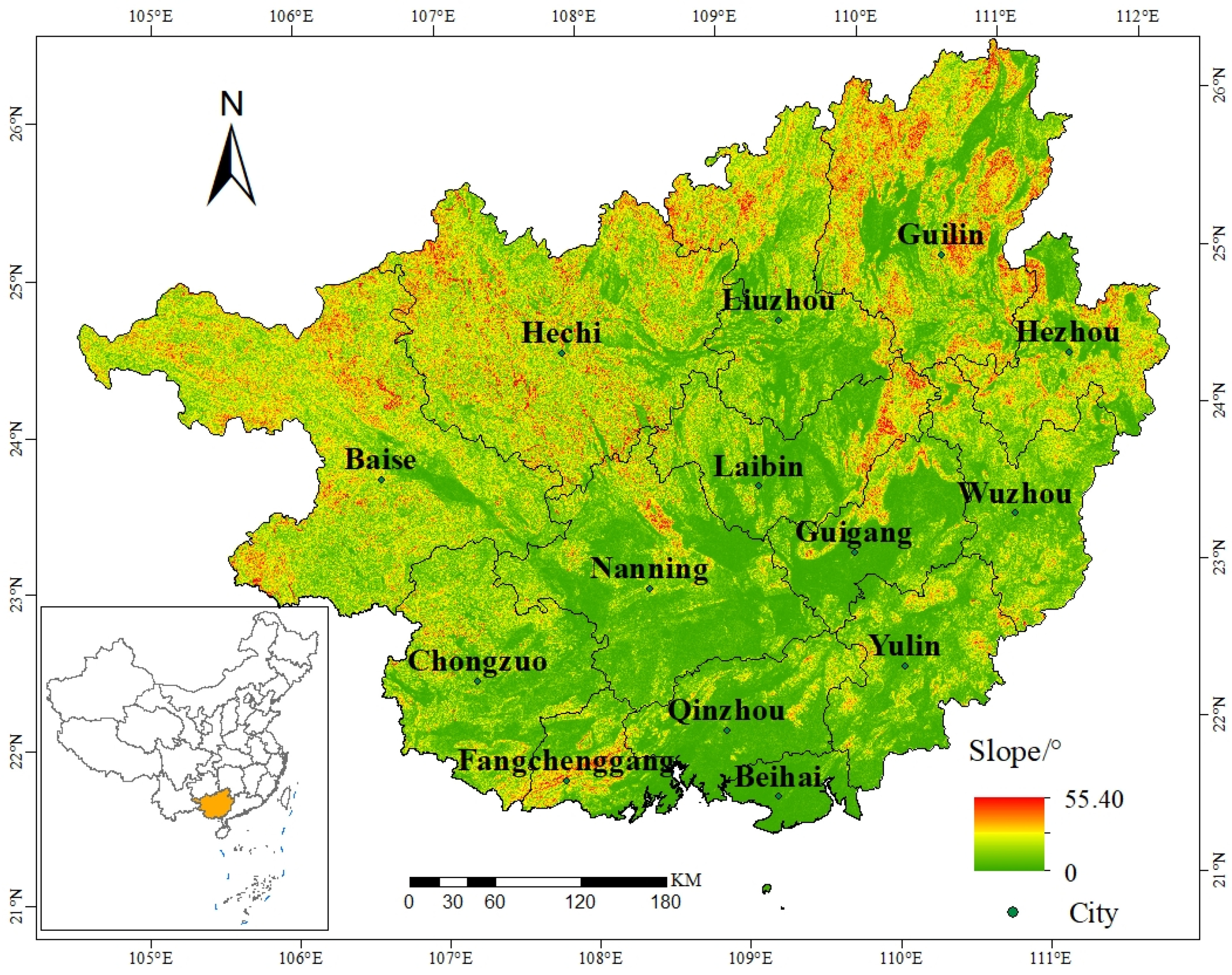
Guangxi is rich in water resources and biodiversity, high mountains and steep slopes, extensive rock desertification, and serious soil erosion. There are obvious regional differences in the evaluation results of ecological protection importance, which are closely related to the natural factors and human activities in each region. Among them, the natural factors are mainly: topography, geology, precipitation, and other factors. The main characteristics of Guangxi topography are more mountains and less plains and high mountains and steep slopes, while the slopes are extremely prone to soil erosion. The soil in this area is mostly formed by rock weathering, and this soil has loose structure and poor water storage capacity, and high temperature and rain are very likely to cause collapse of steep slope sections. Precipitation is an important factor causing regional soil erosion and rock desertification, and is also an essential influencing factor for water connotation. The rainfall in Guangxi is high in the north and low in the south, and the rainfall is concentrated with high intensity, which is easy to cause landslides and soil erosion, so the water connotation function, soil erosion, and stone desertification sensitivity in northern Guangxi is obviously greater than that in southern Guangxi. A forest is an important ecosystem for water conservation and an essential habitat for maintaining biodiversity. Woodlands in Guangxi are widely distributed with an area of 154,957.78 km2, mainly concentrated in the southern part of Hechi, Hezhou, and Wuzhou, which is the reason why the function of water connotation and biodiversity maintenance in this region has become a very important area.
With the acceleration of economic construction and urbanization, the contradiction of more people and less land has increased human demand for land, especially in the central region of Guangxi where human activities are intense and construction land continues to expand, which affects the evaluation results of ecological protection importance in the region. Secondly, indiscriminate logging, excessive mining, and mining have contributed to the continuous reduction in forest coverage and serious soil exposure. In addition, there is a large number of steep slopes to open up wasteland in Guangxi, cutting down the original vegetation to plant fruit trees and crops with economic value, resulting in the intensification of soil erosion and rock desertification.
The reduction in water conservation and soil and water conservation capacity, loss of biodiversity, soil erosion and increased rock desertification will inevitably bring a series of problems, such as land degradation and serious landscape fragmentation, which in turn restricts the development of local agriculture and tourism. Secondly, soil erosion leads to increased rock desertification and the formation of stone desertification in the process of causing more serious soil erosion; this vicious circle will lead to frequent occurrence of natural disasters such as droughts and landslides, affecting industrial and agricultural production and the safety of people’s lives and property.
Therefore, it is urgent to carry out ecological security protection and improvement work reasonably. It is necessary to regularly carry out ecological security assessment work, establish and improve the management mechanism and policies and regulations for ecological security protection, and carry out ecological restoration work in different regions, such as: vegetation restoration, returning farmland to forests, industrial poverty alleviation, and other measures.
4.2. Analysis of Ecological Security Patterns
In 2012, the Guangxi Zhuang Autonomous Region People’s Government issued the “Guangxi main functional area plan”, which pointed out that the ecological security pattern of Guangxi is “two screens, four areas and one corridor”. The two screens refer to the western Guangxi ecological barrier and the coastal ecological screen of Beibuwan; the four areas refer to the northeast ecological functional area of Guangxi, the southwest ecological functional area of Guangxi, the central ecological functional area of Guangxi, and the Shiwan mountain ecological reserve; the one corridor refers to the Xijiang Qianli Green Corridor. The spatial distribution and main functions of the four functional areas in the plan are basically consistent with the results of this study, but there are differences in the ecological screens and ecological corridors, among which the Beibuwan coastal ecological screen is an ecological screen constructed mainly by coastal windbreak forest and marine ecological restoration, while this study only focuses on ecological construction with Guangxi land, and further marine ecological protection is needed in the future. For the identification of ecological corridors in Guangxi, the planning targets afforestation and water ecological environment protection and the area along the Xijiang River as the ecological corridor in Guangxi, but this study identifies multiple ecological corridors by combining the resistance surface and the least-cost path.
This study shows that the ecological security pattern of Guangxi consists of ecological sources, ecological corridor, ecological pinch point, and ecological barrier point. Ecological sources are the key area for regional ecological construction and ecological protection, and targeted protection and construction should be carried out in combination with the main functions of ecological sources. There are 115 ecological corridors in Guangxi, ecological sources are connected with each other by ecological corridors, and there are 63 corridors with lengths over 10 km. Excessive lengths will make ecological corridors more sensitive and reduce their resistance to internal and external disturbances. Therefore, it is necessary to focus on protecting the environment around key ecological corridors, while enhancing the number and area of ecological sources, thus reducing the length of ecological corridors and strengthening the stability and circulation of ecological corridors. Guangxi ecological pinch points and barrier points are mostly distributed on ecological corridors, and the ecological resistance around these areas should be appropriately reduced to enhance landscape connectivity and improve the stability and anti-disturbance ability of ecological security patterns.
4.3. Study Shortcomings
Due to the limitations of data collection and model accuracy, this study only combined the results of ecosystem service function importance and ecological sensitivity evaluation to identify ecological sources, without considering local nature reserves, scenic spots, and restricted development zones, etc. Therefore, future research needs to consider many aspects when identifying ecological sources, and needs to combine nature reserves, scenic spots, and restricted development areas zones, etc. Second, the methods and standards for the construction of ecological resistance surfaces are not yet unified, resulting in differences in ecological security patterns, hence it is necessary to formulate targeted ecological resistance surface construction methods and standards in combination with the characteristics of the regional ecological environment. In addition, the research on the optimization and management of ecological safety patterns is relatively weak, the current ecological pattern research mainly focuses on the construction of ecological security patterns, and there is less research on subsequent optimization and management, which needs to consider the optimization and management of ecological security patterns in future research.


 ,
, 


