
Research on the Coordinated Development of Population–Resources–Environment (PRE) Systems: An Empirical Analysis from Jiangsu Province, China

Abstract
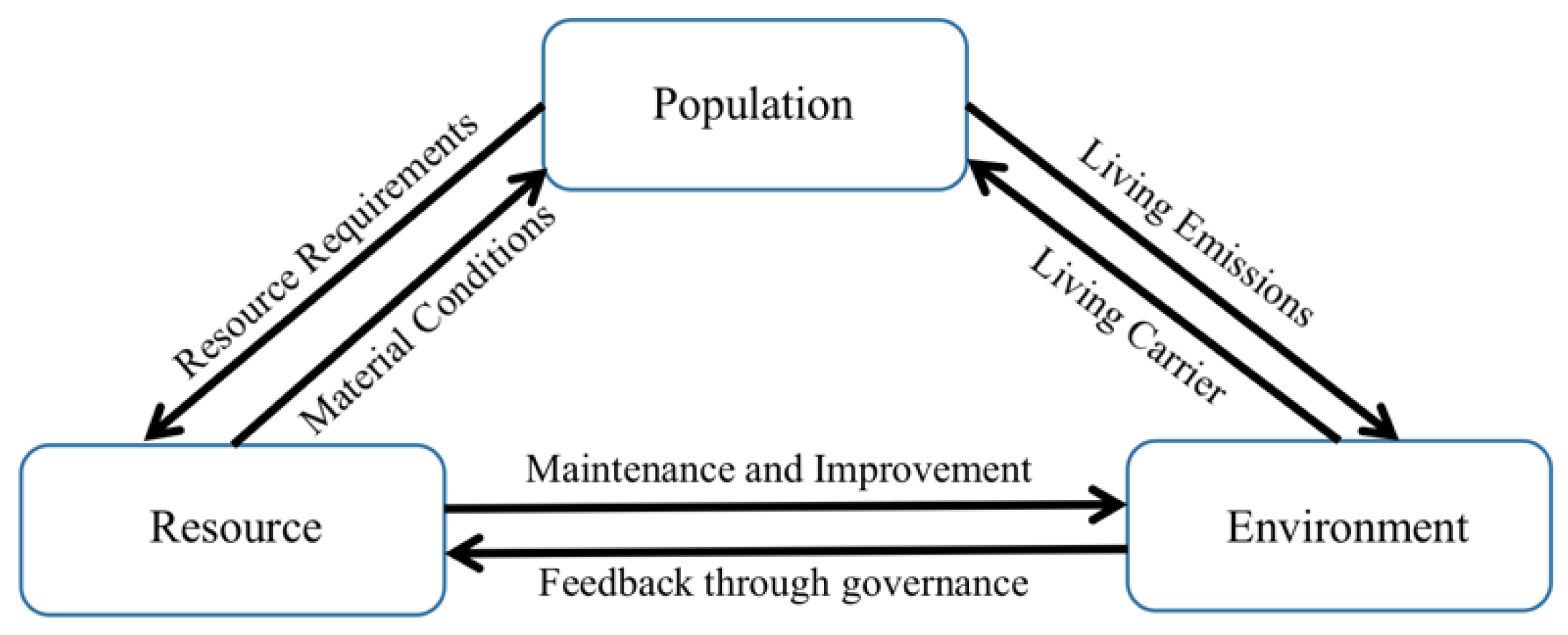
:1. Introduction
2. Research Design and Methods
2.1. Research Area
2.2. Construction of an Indicator System
2.3. Research Methodology
2.3.1. Evaluation Method
2.3.2. Coupling Model and Coupling Coordination Degree Model
2.3.3. Model Construction of Driving Factors
3. Research Results
3.1. Evaluation Results
3.2. Estimation Results of the Degree of Coupling Coordination
3.3. Regression Results of the Driving Factors of Coupling Coordination Degree
4. Discussion
4.1. An Increase in the Population Urbanization Rate Increases Pressure on the Resource and Environment
4.2. Resource Use Efficiency Still Needs to Be Improved
4.3. Avoid Failure to Carry Out Timely Environmental Management after Environmental Pollution
4.4. The Imbalance in Regional Development Is More Obvious
5. Conclusions and Policy Implications
5.1. Conclusions
5.2. Policy Implications
- (1)
- The reasonable gathering of the population in urban clusters and the citizenship of the agricultural transfer population should be promoted. The population should be concentrated in urban agglomerations, and the main purpose of urban agglomerations would be to promote the coordinated development of large, small, and medium-sized cities and small towns with an emphasis on promoting the co-location of the Nanjing metropolitan area and the Nanjing–Zhenjiang–Yangzhou metropolitan area and the integration of the Suzhou–Wuxi–Changzhou metropolitan area. While fully respecting the right of the agricultural transfer population to make their own choices, we should accelerate the citizenship of the agricultural transfer population while creating conditions for them to truly become integrated and enjoy urban security.
- (2)
- The government needs to effectively use the existing resources and develop new green energy sources. First, the government needs to strengthen the legislation and improve the laws and regulations for protecting natural resources to ensure the sustainable use of resources. Second, the government needs to strictly control the exploitation of natural resources and improve the comprehensive utilization rate of resources in all aspects. In addition, the government needs to strengthen the development of new energy, eliminate the backward production capacity, and cultivate and grow the new energy industry. Finally, the government needs to promote the process of carbon neutralization for carbon peaks, comprehensively promote clean production, accelerate the green development of agriculture, and vigorously promote the energy-saving renovation of existing buildings and municipal infrastructures in cities and towns.
- (3)
- The ecology and environment department needs to improve environmental protection mechanisms and increase environmental protection governance. First of all, the department needs to grasp the work of air governance while controlling pollution from emissions. Second, the department needs to promote green low-carbon cycle developments, adjust the layout, scale, and structure of industries that do not meet the positioning of ecological and environmental functions and build a green industrial chain system. Finally, the department needs to improve and perfect the environmental protection system, provide corresponding encouragement and support to production activities and consumption behaviors that actively promote environmental protection, and at the same time, strengthen the reform of environmental supervision and implement the supervision of the whole society.
- (4)
- It is necessary to strengthen regional cooperation and narrow regional differences. Jiangsu must continue to promote the sharing of resources and use the “enclave economy” model to promote regional integration and development. The capital and technology from southern Jiangsu Province and the raw materials and labor resources of northern Jiangsu Province should be jointly developed to realize the complementary transfer of industries between northern Jiangsu Province and southern Jiangsu Province. The aim is to realize the development of industrial linkages and to promote the coordinated development of the population, resources, and environment in Jiangsu Province.
5.3. Limitation
Author Contributions
Funding
Institutional Review Board Statement
Informed Consent Statement
Data Availability Statement
Conflicts of Interest
References
- Grossman, G.M.; Krueger, A.B. Economic Growth and the Environment. NBER Work. Pap. 1994, 110, 353–377. [Google Scholar]
- Daly, H.E. Beyond Growth: The Economics of Sustainable Environment; Beacon Press: Boston, MA, USA, 1996; Volume 29, p. 6. [Google Scholar]
- National Bureau of Statistics of China. Statistical Bulletin on National Economic and Social Development of the People’s Republic of China in 2021; National Bureau of Statistics of China: Beijing, China, 2022.
- Cao, J.; Zhang, Y.; Wei, T.; Sun, H. Temporal–Spatial Evolution and Influencing Factors of Coordinated Development of the Population, Resources, Economy and Environment (PREE) System: Evidence from 31 Provinces in China. Int. J. Environ. Res. Public Health 2021, 18, 13049. [Google Scholar] [CrossRef] [PubMed]
- Mori, K.; Christodoulou, A. Review of sustainability indices and indicators: Towards a new City Sustainability Index (CSI). Environ. Impact Assess. Rev. 2012, 32, 94–106. [Google Scholar] [CrossRef]
- Bell, S.; Morse, S. (Eds.) Routledge Handbook of Sustainability Indicators; Routledge Taylor & Francis Group: London, UK; New York, NY, USA, 2018. [Google Scholar]
- Tiba, S.; Omri, A. Literature survey on the relationships between energy, environment and economic growth. Renew. Sustain. Energy Rev. 2017, 69, 1129–1146. [Google Scholar] [CrossRef]
- Begum, R.; Sohag, K.; Abdullah, S.M.S.; Jaafar, M. CO2 emissions, energy consumption, economic and population growth in Malaysia. Renew. Sustain. Energy Rev. 2015, 41, 594–601. [Google Scholar] [CrossRef]
- Yan, Y.F.; Zhang, X.R. Reflections on the Chinese Policy for the Development and Utilization of Resources. China Popul. Resour. Environ. 2013, 23, 38–41. (In Chinese) [Google Scholar]
- Ahmed, Z.; Asghar, M.; Malik, M.; Nawaz, K. Moving towards a sustainable environment: The dynamic linkage between natural resources, human capital, urbanization, economic growth, and ecological footprint in China. Resour. Policy 2020, 67, 101677. [Google Scholar] [CrossRef]
- Onifade, S.; Gyamfi, B.; Haouas, I.; Bekun, F.V. Re-examining the roles of economic globalization and natural resources consequences on environmental degradation in E7 economies: Are human capital and urbanization essential components. Resour. Policy 2021, 74, 102435. [Google Scholar] [CrossRef]
- Wang, Q.; Yuan, X.; Cheng, X.; Mu, R.; Zuo, J. Coordinated development of energy, economy and environment subsystems—A case study. Ecol. Indic. 2014, 46, 514–523. [Google Scholar] [CrossRef]
- Fang, C.; Cui, X.; Li, G. Modeling regional sustainable development scenarios using the urbanization and eco-environment coupler: Case study of Beijing-Tianjin-Hebei urban agglomeration, China. Sci. Total Environ. 2019, 59, 102208. [Google Scholar] [CrossRef]
- Liu, H.; Liu, Y.; Wang, H.; Yang, J.; Zhou, X. Research on the coordinated development of greenization and urbanization based on system dynamics and data envelopment analysis—A case study of Tianjin. J. Clean. Prod. 2019, 214, 195–208. [Google Scholar] [CrossRef]
- Zhang, Q.; Wang, L.; Wu, F.; Yuan, L.; Zhao, L. Quantitative evaluation for coupling coordinated development between ecosystem and economic system-case study of Chinese loess plateau. J. Urban Plan. Dev. 2012, 138, 328–334. [Google Scholar] [CrossRef]
- Sun, Q.; Zhang, X.; Zhang, H.; Niu, H. Coordinated development of a coupled social economy and resource environment system: A case study in Henan Province, China. Environ. Dev. Sustain. 2018, 20, 1385–1404. [Google Scholar] [CrossRef]
- Chu, N.; Zhang, P.; Wu, X. Spatiotemporal evolution characteristics of urbanization and its coupling coordination degree in Russia—Perspectives from the population, economy, society, and eco-environment. Environ. Sci. Pollut. Res. 2022, 29, 61334–61351. [Google Scholar] [CrossRef] [PubMed]
- Lv, T.; Wang, L.; Zhang, X.; Xie, H.; Lu, H.; Li, H.; Liu, W.; Zhang, Y. Coupling Coordinated Development and Exploring Its Influencing Factors in Nanchang, China: From the Perspectives of Land Urbanization and Population Urbanization. Land 2019, 8, 178. [Google Scholar] [CrossRef] [Green Version]
- Ji, J.; Wang, S.; Zhou, Y.; Liu, W.; Wang, L. Spatiotemporal Change and Coordinated Development Analysis of “Population-Society-Economy-Resource-Ecology-Environment” in the Jing-Jin-Ji Urban Agglomeration from 2000 to 2015. Sustainability 2021, 13, 4075. [Google Scholar] [CrossRef]
- Hou, Y.; Chen, Z. A study on the threshold effect of population development on resource consumption and environmental pollution in China. Econ. Sci. 2018, 3, 75–88. (In Chinese) [Google Scholar]
- Lu, C.; Yang, J.; Li, H.; Jin, S.; Pang, M.; Lu, C. Research on the Spatial–Temporal Synthetic Measurement of the Coordinated Development of Population-Economy-Society-Resource-Environment (PESRE) Systems in China Based on Geographic Information Systems (GIS). Sustainability 2019, 11, 2877. [Google Scholar] [CrossRef] [Green Version]
- Shi, T.; Yang, S.; Zhang, W.; Zhou, Q. Coupling coordination degree measurement and spatiotemporal heterogeneity between economic development and ecological environment—Empirical evidence from tropical and subtropical regions of China. J. Clean. Prod. 2020, 244, 118739. [Google Scholar] [CrossRef]
- Xing, L.; Xue, M.; Hu, M. Dynamic simulation and assessment of the coupling coordination degree of the economy–resource–environment system: Case of Wuhan City in China. J. Environ. Manag. 2019, 230, 474–487. [Google Scholar] [CrossRef]
- Wang, R.; Cheng, J.; Zhu, Y.; Lu, P. Evaluation on the coupling coordination of resources and environment carrying capacity in Chinese mining economic zones. Resour. Policy 2017, 53, 20–25. [Google Scholar] [CrossRef]
- Zeng, R.; Wei, Y.M.; Fan, Y.; Li, Z.J. Analysis and Assessment Indicator System For Harmonization Development Among Population, Resource, Environment and Economy. Chin. J. Manag. Sci. 2000, S1, 310–317. [Google Scholar]
- Bolcárová, P.; Kološta, S. Assessment of sustainable development in the EU 27 using aggregated SD index. Ecol. Indic. 2015, 48, 699–705. [Google Scholar] [CrossRef]
- Zeng, X.; Xiang, H.; Xue, Y.; Su, Y.; Tong, Y.; Mao, Z. A scenario-based optimization frame to adjust current strategy for population-economy-resource-environment harmony in an urban agglomeration, China. Sustain. Cities Soc. 2021, 67, 102710. [Google Scholar] [CrossRef]
- Xu, H.; Hsu, W.-L.; Meen, T.-H.; Zhu, J.H. Can Higher Education, Economic Growth and Innovation Ability Improve Each Other? Sustainability 2020, 12, 2515. [Google Scholar] [CrossRef] [Green Version]
- Li, H.J.; Qu, J.S.; Pang, J.X.; Xu, L.; Han, J.Y. Spatial-Temporal Synthetic Measurement of Coupling Coordination and Sustainable Development of Population-Economy-Society-Resource-Environment System in Gansu Province. Arid. Land Geogr. 2020, 43, 1622–1634. [Google Scholar]
- Shmelev, S.E.; Shmeleva, I.A. Global urban sustainability assessment: A multidimensional approach. Sustain. Dev. 2018, 26, 904–920. [Google Scholar] [CrossRef]
- Kan, H.; Chen, R.; Tong, S. Ambient air pollution, climate change, and population health in China. Environ. Int. 2012, 42, 10–19. [Google Scholar] [CrossRef]
- Jambeck, J.; Geyer, R.; Wilcox, C.; Siegler, T.R.; Perryman, M.; Andrady, A.; Narayan, R.; Law, K.L. Plastic waste inputs from land into the ocean. Science 2015, 347, 768–771. [Google Scholar] [CrossRef]
- He, C.; Pan, F.; Yan, Y. Is Economic Transition Harmful to China’s Urban Environment? Evidence from Industrial Air Pollution in Chinese Cities. Urban Stud. 2012, 49, 1767–1790. [Google Scholar] [CrossRef]
- Li, W.; Liu, Y.; Yin, X. Uneven resource utilization: An explanation from demographic structure effect. China Popul. Resour. Environ. 2017, 27, 4. (In Chinese) [Google Scholar]
- Cao, L.; Wang, J.; Wang, H.; Cui, H. Analysis of the coupled evolution of infrastructure construction and population agglomeration in Beijing-Tianjin-Hebei--based on the analysis of push-pull theory. Geoscience 2019, 39, 9. (In Chinese) [Google Scholar]
- Chen, Z.; Wang, Q. A study on the coordination of urbanization and arable land resources--an empirical analysis of Jiangsu Province as an example. Ecol. Econ. 2005, 11, 42–44. (In Chinese) [Google Scholar]
- Gan, T.; Yang, H.; Liang, W. How do urban haze pollution and economic development affect each other? Empirical evidence from 287 Chinese cities during 2000–2016. Sustain. Cities Soc. 2021, 65, 102642. [Google Scholar] [CrossRef]
- Wu, X.; Li, L. How has urbanization affected the health of the population? Nankai Econ. Res. 2014, 16, 58–73. (In Chinese) [Google Scholar]
- Pedersen, M.; Giorgis-Allemand, L.; Bernard, C.; Aguilera, I.; Andersen, A.M.; Ballester, F.; Beelen, R.M.; Chatzi, L.; Cirach, M.; Danileviciute, A.; et al. Ambient air pollution and low birthweight: A European cohort study (ESCAPE). Lancet Respir. Med. 2013, 1, 695–704. [Google Scholar] [CrossRef] [PubMed]
- Elavarasan, R.; Pugazhendhi, R.; Irfan, M.; Mihet-Popa, L.; Khan, I.A.; Campana, P.E. State-of-the-art sustainable approaches for deeper decarbonization in Europe-An endowment to climate neutral vision. Renew. Sustain. Energy Rev. 2022, 159, 112204. [Google Scholar] [CrossRef]
- Murshed, M.; Nurmakhanova, M.; Al-Tal, R.; Mahmood, H.; Elheddad, M.; Ahmed, R. Can intra-regional trade, renewable energy use, foreign direct investments, and economic growth mitigate ecological footprints in South Asia? Energy Sources Part B Econ. Plan. Policy 2022, 17, 2038730. [Google Scholar] [CrossRef]


| System Layer | Criterion Layer | Indicator Layer | Indicator Efficacy | References |
|---|---|---|---|---|
| Population System | Population Size | Natural population growth rate (‰) | − | [5,13,18,19] |
| Population density (person/) | − | [4,5,16,18,27,28] | ||
| Population Structure | Percentage of population aged 65 and above (%) | − | [4,16,29,30] | |
| Population urbanization rate (%) | + | [4,16,27,28,29] | ||
| Population quality | Life expectancy per capita (years) | + | [14,17,28] | |
| Number of invention patents per 10,000 people (pieces) | + | [19,27,28] | ||
| Resource System | Resource Endowment | Water possession per capita () | + | [4,16,18,19,22] |
| Land area owned per capita () | + | [4,19,20,22,29] | ||
| Resource Utilization | Crop sown area per capita (acres) | + | [4,19,22,29] | |
| Completed housing construction area per capita () | + | [22,23,24] | ||
| Environmental System | Environmental Pressure | Annual average concentration of respirable particulate matter () | − | [4,16,27,28,29] |
| Industrial wastewater discharge compliance rate (%) | + | [4,16,27,28,29] | ||
| Environmental Response | Comprehensive utilization rate of industrial solid waste (%) | + | [4,19,20,27,29] | |
| Urban municipal sewage treatment rate (%) | + | [4,16,19,20,29,30] |
| Variable Type | Variable Name | Variable Symbol |
|---|---|---|
| Dependent variable | Coupling coordination degree | D |
| Independent variable | Population density | popd |
| Population urbanization rate | urb | |
| Land area owned per capita | land | |
| Crop sown area per capita | csa | |
| Annual average concentration of respirable particulate matter | rpm | |
| Urban municipal sewage treatment rate | str |
| Level | Coupling Coordination Degree | Coupling Coordination Status |
|---|---|---|
| I | 0 ≤ D ≤ 0.24 | Disorder |
| II | 0.24 < D ≤ 0.32 | On the verge of disorder |
| III | 0.32 < D ≤ 0.50 | Basic coupling coordination |
| IV | 0.50 < D ≤ 0.65 | Moderate coupling coordination |
| V | 0.65 < D ≤ 0.70 | Coupling coordination |
| VI | 0.70 < D ≤ 1.00 | High-level coupling coordinated |
| Area | Index and Level | 2000 | 2005 | 2010 | 2015 | 2020 |
|---|---|---|---|---|---|---|
| Nanjing | Index | 0.3014 | 0.3148 | 0.4651 | 0.6920 | 0.7424 |
| Level | II | II | III | V | VI | |
| Suzhou | Index | 0.2437 | 0.2651 | 0.2842 | 0.6242 | 0.7129 |
| Level | II | II | II | IV | VI | |
| Wuxi | Index | 0.2497 | 0.2419 | 0.3178 | 0.5811 | 0.6320 |
| Level | II | II | II | IV | IV | |
| Changzhou | Index | 0.2534 | 0.2706 | 0.3742 | 0.6191 | 0.6589 |
| Level | II | II | III | IV | V | |
| Zhenjiang | Index | 0.2692 | 0.2572 | 0.3605 | 0.6622 | 0.6694 |
| Level | II | II | III | V | V | |
| Yangzhou | Index | 0.3087 | 0.3643 | 0.4871 | 0.6119 | 0.6224 |
| Level | II | III | III | IV | IV | |
| Nantong | Index | 0.3097 | 0.3553 | 0.4610 | 0.6242 | 0.6608 |
| Level | II | III | III | IV | V | |
| Taizhou | Index | 0.2942 | 0.3726 | 0.4665 | 0.6240 | 0.6683 |
| Level | II | III | III | IV | V | |
| Xuzhou | Index | 0.2562 | 0.2826 | 0.3114 | 0.4293 | 0.4499 |
| Level | II | II | II | III | III | |
| Lianyungang | Index | 0.3415 | 0.3492 | 0.3426 | 0.4145 | 0.4263 |
| Level | III | III | III | III | III | |
| Suqian | Index | 0.3207 | 0.3525 | 0.3458 | 0.4052 | 0.4164 |
| Level | III | III | III | III | III | |
| Huaian | Index | 0.3593 | 0.3858 | 0.4204 | 0.4790 | 0.5486 |
| Level | III | III | III | III | IV | |
| Yancheng | Index | 0.3337 | 0.3866 | 0.4092 | 0.4811 | 0.5421 |
| Level | III | III | III | III | IV |
| Variable | Initial Model | Modified Model | ||||
|---|---|---|---|---|---|---|
| Coefficient | t Statistic | p Value | Coefficient | t Statistic | p Value | |
| cons | 0.4867 *** | 98.742 | 0.0000 | 0.4868 *** | 105.555 | 0.0000 |
| popd | 0.0194 | 1.031 | 0.0002 | |||
| urb | 0.1877 *** | 5.123 | 0.3201 | 0.1673 *** | 9.830 | 0.0000 |
| land | −0.0447 | −1.438 | 0.1724 | |||
| csa | 0.0348 | 1.346 | 0.1996 | 0.0511 ** | 3.494 | 0.0030 |
| rpm | 0.0205 | 1.903 | 0.0778 | 0.0195 * | 2.435 | 0.0269 |
| str | −0.0327 | −1.019 | 0.3260 | |||
| Adjust-R2 | 0.9876 | 0.9881 | ||||
| F | 267.2 | 414.5 | ||||
Disclaimer/Publisher’s Note: The statements, opinions and data contained in all publications are solely those of the individual author(s) and contributor(s) and not of MDPI and/or the editor(s). MDPI and/or the editor(s) disclaim responsibility for any injury to people or property resulting from any ideas, methods, instructions or products referred to in the content. |
© 2022 by the authors. Licensee MDPI, Basel, Switzerland. This article is an open access article distributed under the terms and conditions of the Creative Commons Attribution (CC BY) license (https://creativecommons.org/licenses/by/4.0/).
Share and Cite
Zhao, Q.; Huang, J.; Yu, J.; Du, X.; Li, C. Research on the Coordinated Development of Population–Resources–Environment (PRE) Systems: An Empirical Analysis from Jiangsu Province, China. Int. J. Environ. Res. Public Health 2023, 20, 252. https://doi.org/10.3390/ijerph20010252
Zhao Q, Huang J, Yu J, Du X, Li C. Research on the Coordinated Development of Population–Resources–Environment (PRE) Systems: An Empirical Analysis from Jiangsu Province, China. International Journal of Environmental Research and Public Health. 2023; 20(1):252. https://doi.org/10.3390/ijerph20010252
Chicago/Turabian StyleZhao, Qian, Jianyuan Huang, Jiahao Yu, Xiao Du, and Cong Li. 2023. "Research on the Coordinated Development of Population–Resources–Environment (PRE) Systems: An Empirical Analysis from Jiangsu Province, China" International Journal of Environmental Research and Public Health 20, no. 1: 252. https://doi.org/10.3390/ijerph20010252