
Impact of Land Use Change on the Habitat Quality Evolution in Three Gorges Reservoir Area, China


Abstract
:1. Introduction
2. Material and Methods
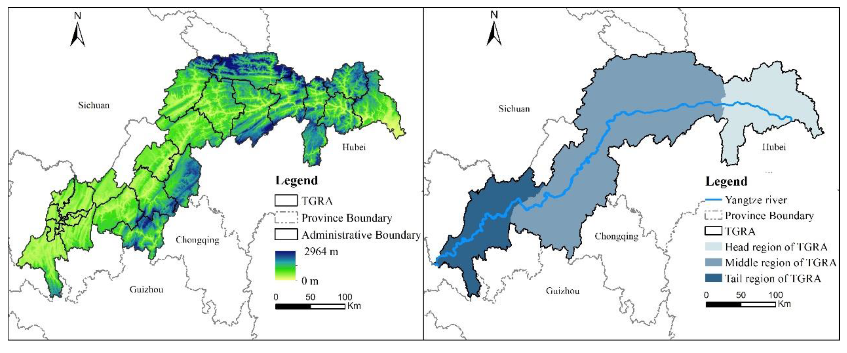
2.1. Study Area
2.2. Data Sources
2.3. Study Methods
2.3.1. Analysis of Land Use Change Methods
- (1)
- Land Use Transfer Matrix
- (2)
- The Land Use Rate Model
- (3)
- Landscape Pattern Index Analysis
2.3.2. InVEST Model
2.3.3. Spatial Auto-Correlation and Hot Spot Analysis
2.3.4. Multiscale Geographically Weighted Regression (MGWR) Model
3. Results
3.1. Temporal and Spatial Variation Characteristics of Land Use in the TGRA
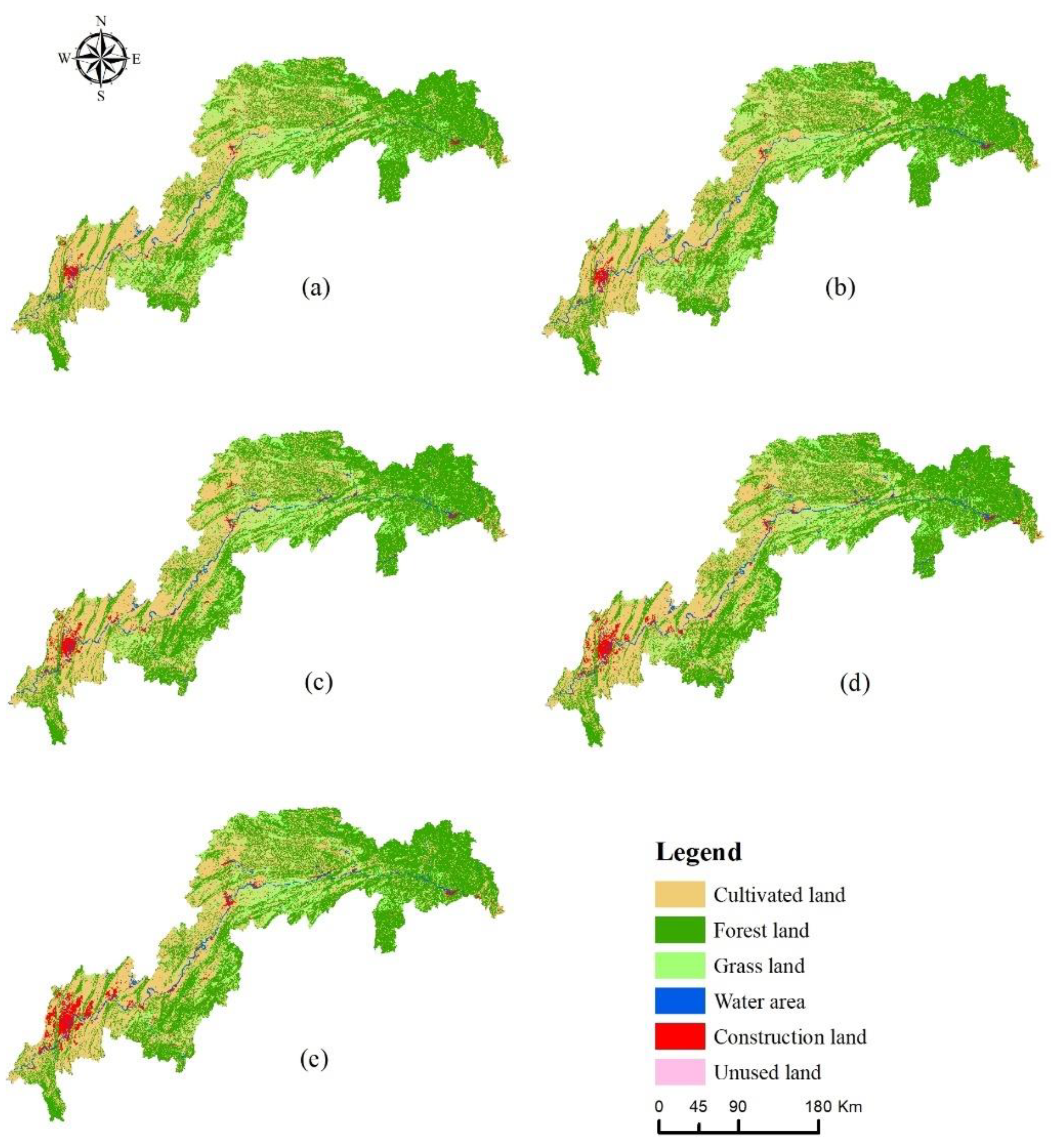
3.1.1. Land Use Change Analysis
3.1.2. Land Use Transfer Analysis
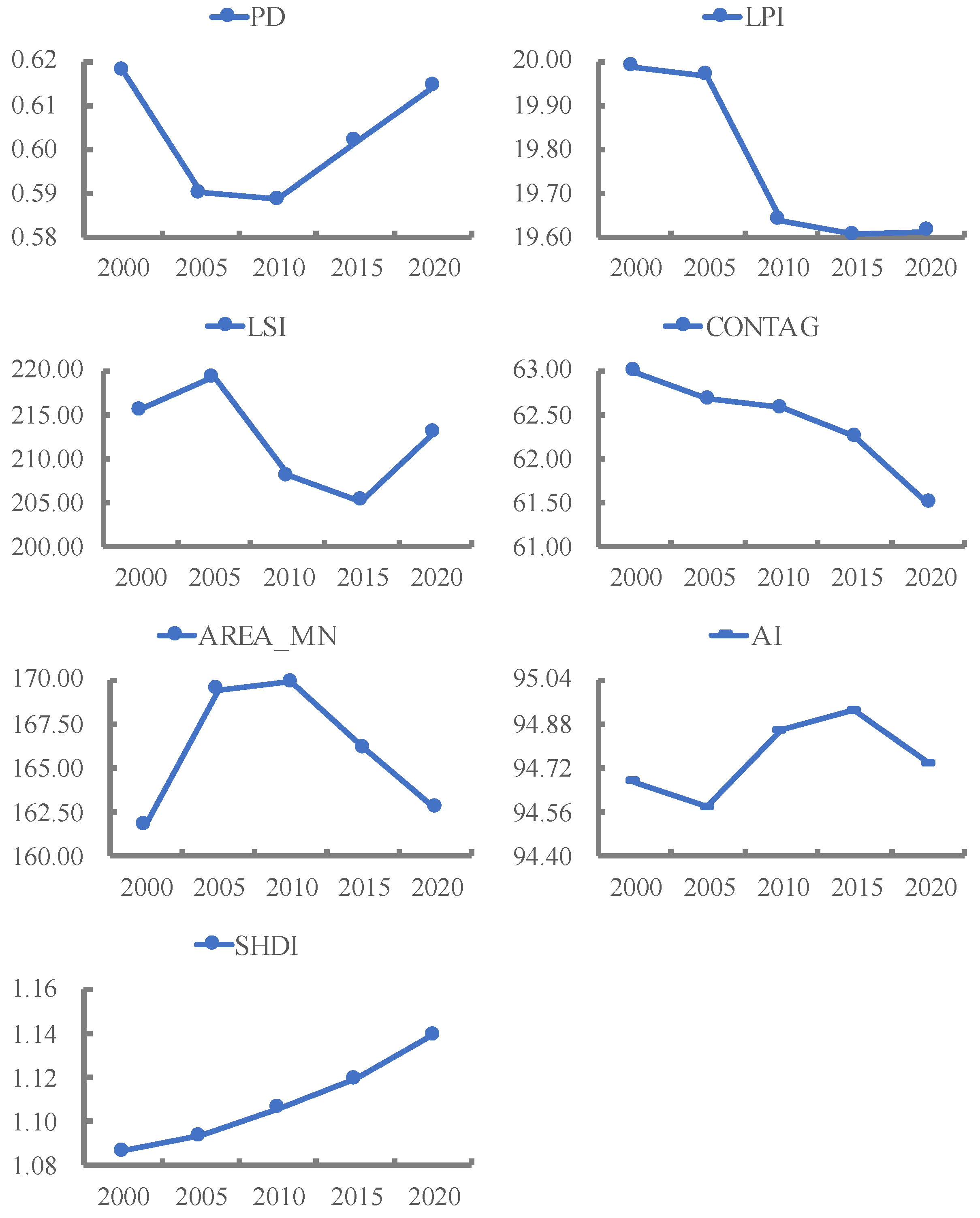
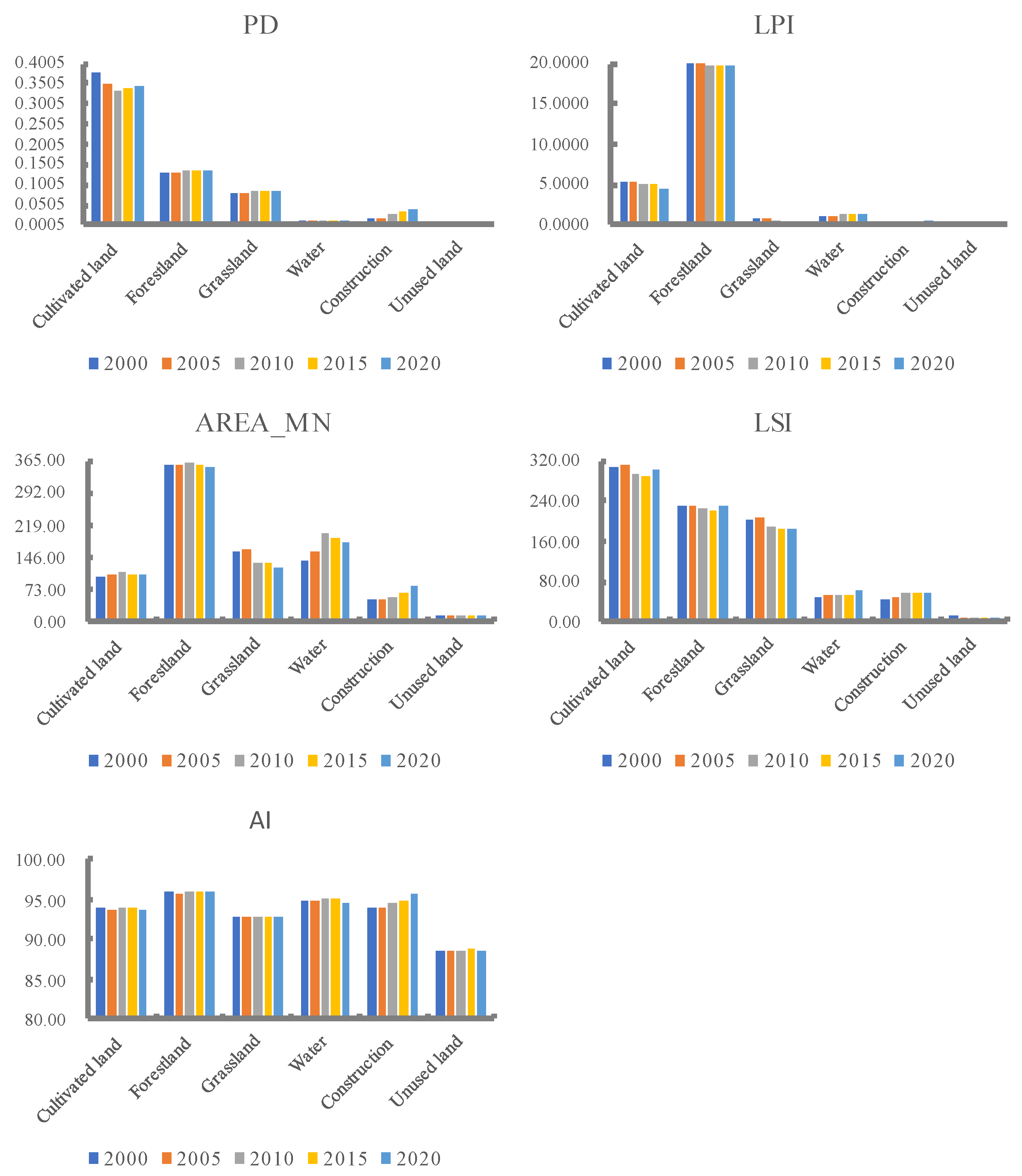
3.1.3. Landscape Pattern Index Change Analysis
3.2. Temporal and Spatial Variation Characteristics of Habitat Quality in the TGRA
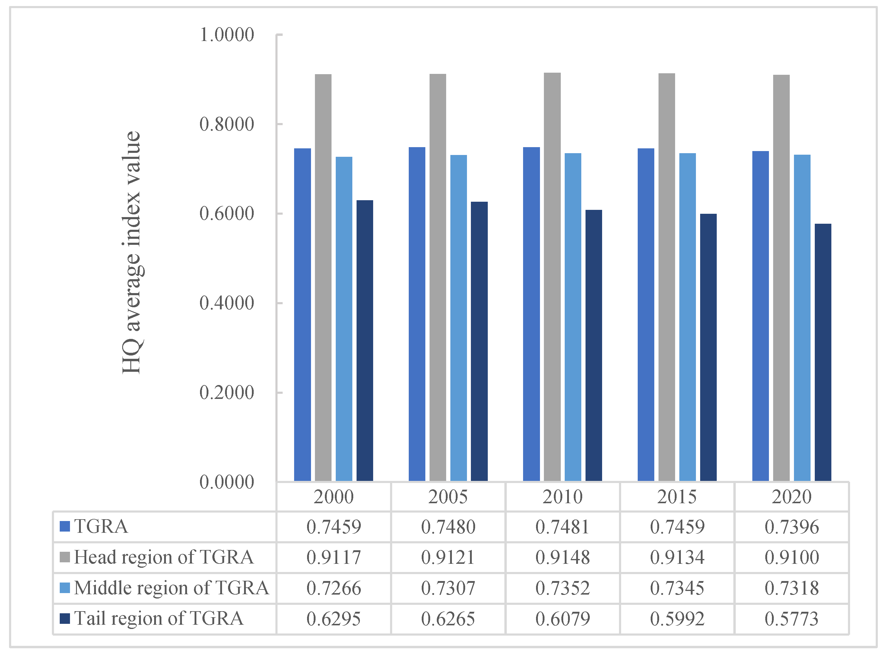
3.2.1. Temporal Variation of HQ
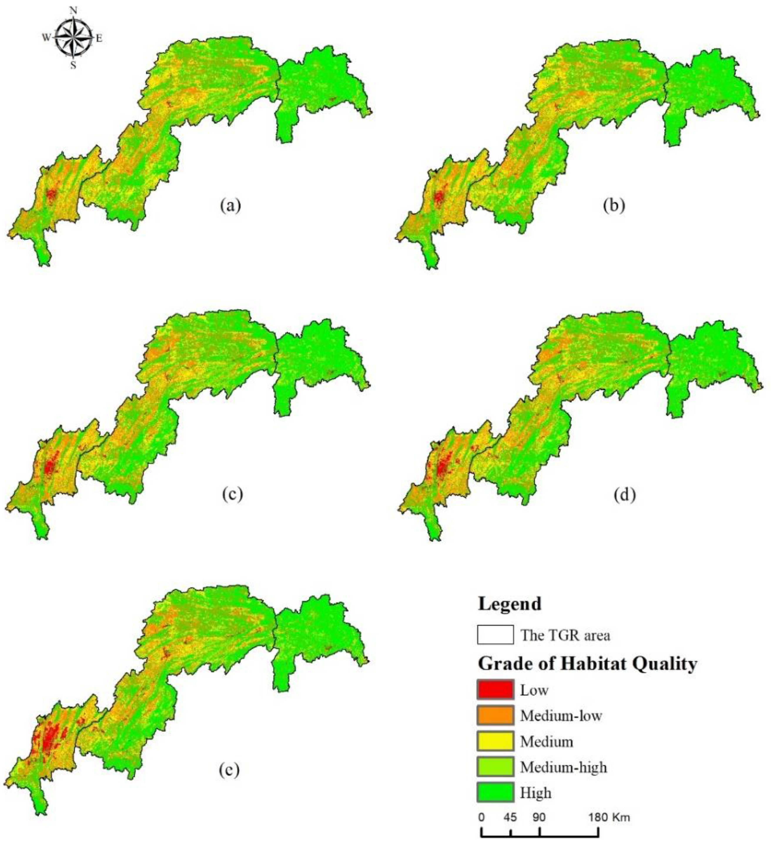
3.2.2. Spatial Variation of HQ
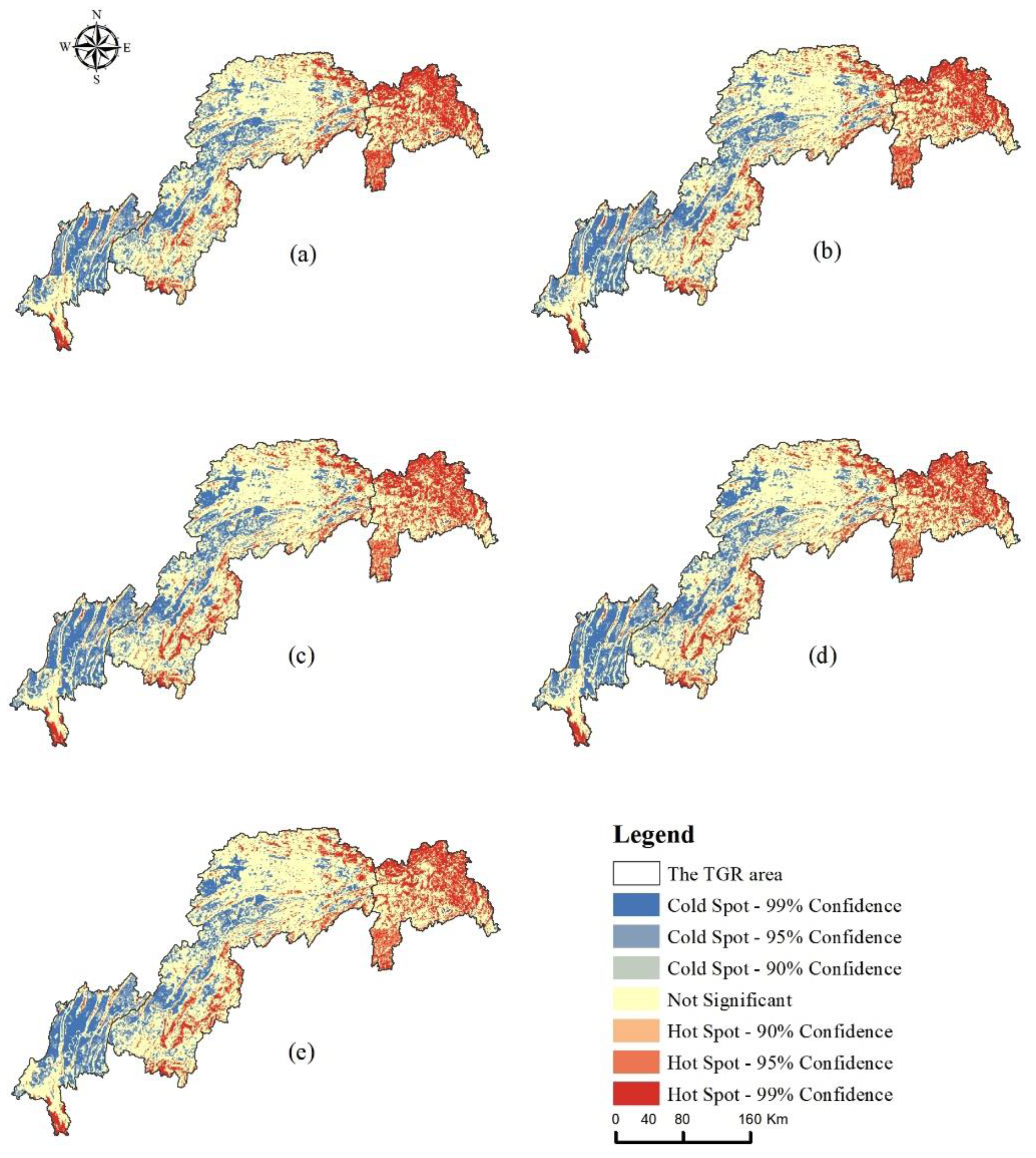
3.2.3. Spatial Auto-Correlation Analysis of HQ Value
3.3. Impact of Land Use Change on HQ
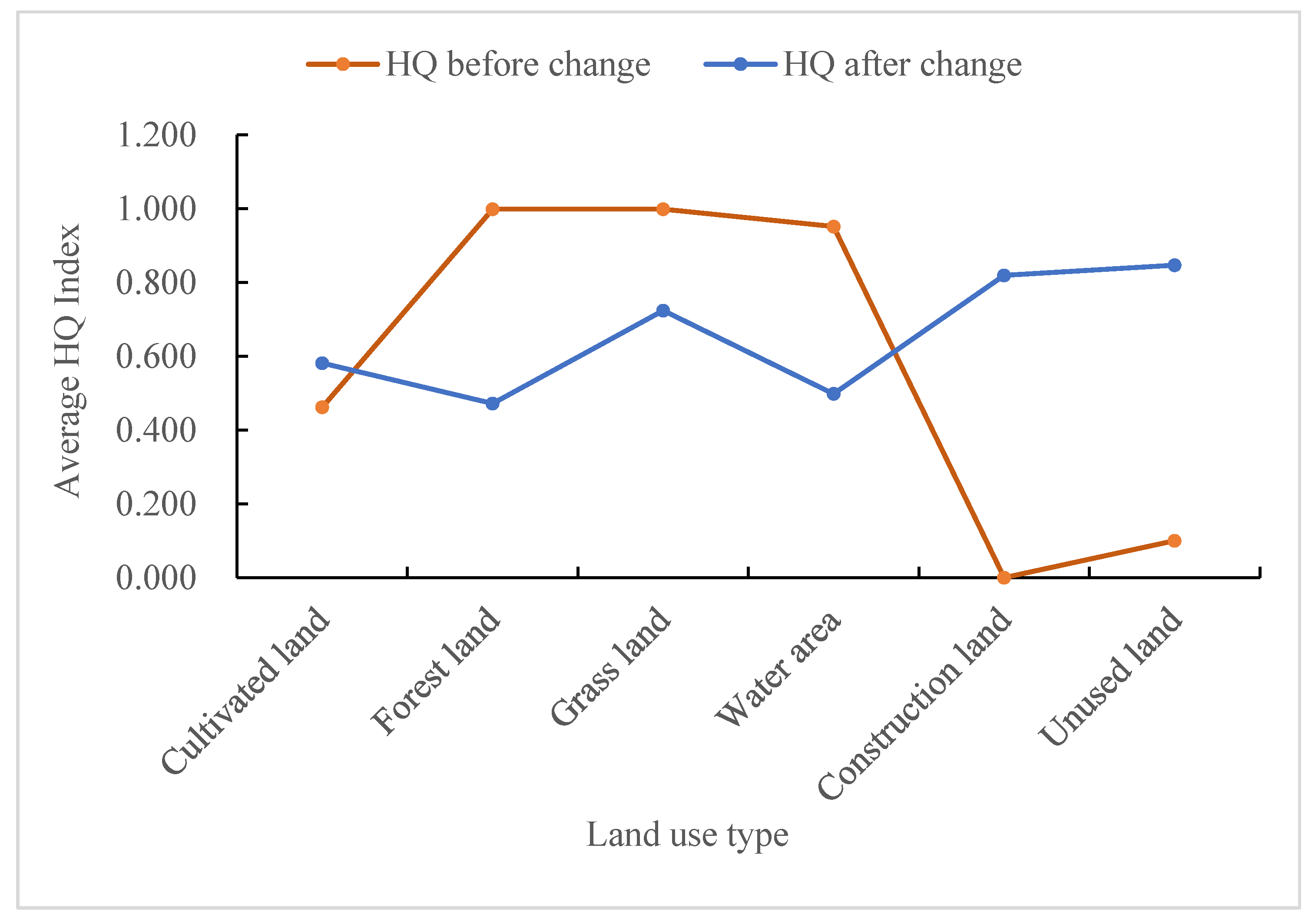
3.3.1. Analysis of HQ Change Based on Land Use Change
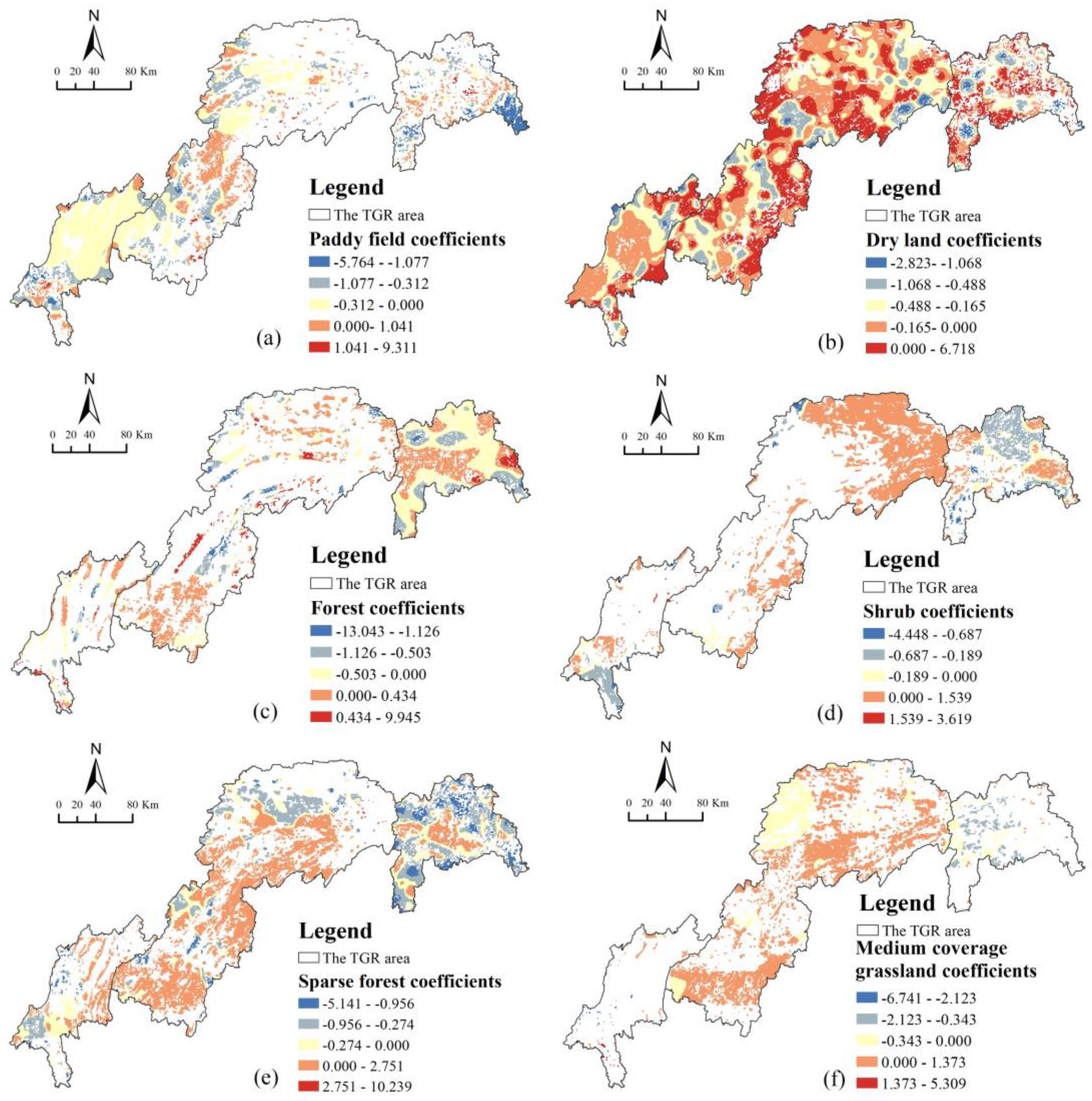
3.3.2. Response Analysis of HQ to Land Use Change
4. Discussion
4.1. Impact of Land Use Change on HQ
4.2. Habitat Quality Improvement and Ecological Conservation Strategies
4.3. Research Contribution and Shortcomings
5. Conclusions
Author Contributions
Funding
Institutional Review Board Statement
Informed Consent Statement
Data Availability Statement
Conflicts of Interest
References
- Hall, L.S.; Krausman, P.R.; Morrison, M.L. The habitat concept and a plea for standard terminology. Wildl. Soc. Bull. 1997, 25, 173–182. [Google Scholar]
- Cardinale, B.J.; Duffy, J.E.; Gonzalez, A.; Hooper, D.U.; Perrings, C.; Venail, P.; Narwani, A.; Mace, G.M.; Tilman, D.; Wardle, D.A.; et al. Biodiversity loss and its impact on humanity. Nature 2012, 486, 59–67. [Google Scholar] [CrossRef] [PubMed]
- Foley, J.A.; DeFries, R.; Asner, G.P.; Barford, C.; Bonan, G.; Carpenter, S.R.; Chapin, F.S.; Coe, M.T.; Daily, G.C.; Gibbs, H.K.; et al. Global consequences of land use. Science 2005, 309, 570–574. [Google Scholar] [CrossRef] [PubMed]
- Fu, F.; Deng, S.; Wu, D.; Liu, W.; Bai, Z. Research on the Spatiotemporal Evolution of Land Use Landscape Pattern in a County Area Based on CA-Markov Model. Sustain. Cities Soc. 2022, 80, 103760. [Google Scholar] [CrossRef]
- Li, S.; Dong, B.; Gao, X.; Xu, H.; Ren, C.; Liu, Y.; Peng, L. Study on spatio-temporal evolution of habitat quality based on land-use change in Chongming Dongtan, China. Environ. Earth Sci. 2022, 81, 220. [Google Scholar] [CrossRef]
- Lopes ND, R.; Li, T.; Qian, D.; Matomela, N.; Sá, R.M. Factors influencing coastal land cover change and the corresponding impact on habitat quality in the North-western Coastline of Guinea-Bissau (NC-GB). Ocean. Coast. Manag. 2022, 224, 106181. [Google Scholar] [CrossRef]
- Aneseyee, A.B.; Noszczyk, T.; Soromessa, T.; Elias, E. The InVEST Habitat Quality Model Associated with Land Use/Cover Changes: A Qualitative Case Study of the Winike Watershed in the Omo-Gibe Basin, Southwest Ethiopia. Remote. Sens. 2020, 12, 1103. [Google Scholar] [CrossRef]
- Wang, B.; Cheng, W. Effects of Land Use/Cover on Regional Habitat Quality under Different Geomorphic Types Based on InVEST Model. Remote Sens. 2022, 14, 1279. [Google Scholar] [CrossRef]
- Honnay, O.; Hermy, M.; Coppin, P. Impact of habitat quality on forest plant species colonization. For. Ecol. Manag. 1999, 115, 157–170. [Google Scholar] [CrossRef]
- Zhiyun, O.; Jianguo, L.; Han, X.; Yingchun, T.; Hemin, Z. An assessment of giant panada habitat in Wolong Nature Reserve. Acta Ecol. Sin. 2001, 21, 1869–1874. [Google Scholar]
- Zlinszky, A.; Heilmeier, H.; Balzter, H.; Czúcz, B.; Pfeifer, N. Remote sensing and GIS for habitat quality monitoring: New approaches and future research. Remote Sens. 2015, 7, 7987–7994. [Google Scholar] [CrossRef]
- Chen, M.; Su, X.L.; Dang, C.Q. Establishment and application of a habitat assessment index system of rivers in the Three Gorges Reservoir Region. Acta Ecol. Sin. 2017, 37, 8433–8444. [Google Scholar]
- He, B.; Chang, J.; Guo, A.; Wang, Y.; Wang, Y.; Li, Z. Assessment of river basin habitat quality and its relationship with disturbance factors: A case study of the Tarim River Basin in Northwest China. J. Arid. Land 2022, 14, 167–185. [Google Scholar] [CrossRef]
- Gong, J.; Xie, Y.; Cao, E.; Huang, Q.; Li, H. Integration of InVEST-habitat quality model with landscape pattern indexes to assess mountain plant biodiversity change: A case study of Bailongjiang watershed in Gansu Province. J. Geogr. Sci. 2019, 29, 1193–1210. [Google Scholar] [CrossRef]
- Du, B.; Wei, J.; Lin, K.; Lu, L.; Ding, X.; Ye, H.; Huang, W.; Wang, N. Spatial and Temporal Variability of Grassland Grasshopper Habitat Suitability and Its Main Influencing Factors. Remote Sens. 2022, 14, 3910. [Google Scholar] [CrossRef]
- Putra, M.I.H.; Mustika, P.L.K. Maximum entropy model: Estimating the relative suitability of cetacean habitat in the northern Savu Sea, Indonesia. Mar. Mammal Sci. 2020, 37, 6–28. [Google Scholar] [CrossRef]
- Liu, H.; Lin, M.; Zhou, R.; Zhong, L. Spatial and temporal evolution of habitat quality in Guangdong-Hong Kong-Macao Greater Bay Area based on InVEST model. Ecol. Sci. 2021, 40, 82–91. [Google Scholar]
- Zhang, H.; Zhang, C.; Hu, T.; Zhang, M.; Ren, X.; Hou, L. Exploration of roadway factors and habitat quality using InVEST. Transp. Res. Part D Transp. Environ. 2020, 87, 102551. [Google Scholar] [CrossRef]
- Sallustio, L.; De Toni, A.; Strollo, A.; Di Febbraro, M.; Gissi, E.; Casella, L.; Geneletti, D.; Munafò, M.; Vizzarri, M.; Marchetti, M. Assessing habitat quality about the spatial distribution of protected areas in Italy. J. Environ. Manag. 2017, 201, 129–137. [Google Scholar] [CrossRef]
- Yohannes, H.; Soromessa, T.; Argaw, M.; Dewan, A. Spatio-temporal changes in habitat quality and linkage with landscape characteristics in the Beressa watershed, Blue Nile basin of Ethiopian highlands. J. Environ. Manag. 2021, 281, 111885. [Google Scholar] [CrossRef]
- Hu, F.; Zhang, Y.; Guo, Y.; Zhang, P.; Lyu, S.; Zhang, C. Spatial and temporal changes in land use and habitat quality in the Weihe River Basin based on the PLUS and InVEST models and predictions. Arid. Land Geogr. 2022, 45, 1125–1136. [Google Scholar]
- Bai, L.; Xiu, C.; Feng, X.; Liu, D. Influence of urbanization on regional habitat quality: A case study of Changchun City. Habitat Int. 2019, 93, 102042. [Google Scholar] [CrossRef]
- Zhao, L.; Yu, W.; Meng, P.; Zhang, J.; Zhang, J. InVEST model analysis of the impacts of land use change on landscape pattern and habitat quality in the Xiaolangdi Reservoir area of the Yellow River basin, China. Land Degrad. Dev. 2022, 33, 2870–2884. [Google Scholar] [CrossRef]
- Xu, H.; Dong, B.; Gao, X.; Xu, Z.; Ren, C.; Fang, L.; Wei, Z.; Liu, X.; Lu, Z. Habitat quality assessment of wintering migratory birds in Poyang Lake National Nature Reserve based on InVEST model. Environ. Sci. Pollut. Res. 2022. [Google Scholar] [CrossRef] [PubMed]
- Zhang, X.; Song, W.; Lang, Y.; Feng, X.; Yuan, Q.; Wang, J. Land use changes in the coastal zone of China’s Hebei Province and the corresponding impacts on habitat quality. Land Use Policy 2020, 99, 104957. [Google Scholar] [CrossRef]
- Wu, J.; Li, X.; Luo, Y.; Zhang, D. Spatiotemporal effects of urban sprawl on habitat quality in the Pearl River Delta from 1990 to 2018. Sci. Rep. 2021, 11, 1–15. [Google Scholar] [CrossRef]
- Dai, L.; Li, S.; Lewis, B.J.; Wu, J.; Yu, D.; Zhou, W.; Zhou, L.; Wu, S. The influence of land use change on the spatial–temporal variability of habitat quality between 1990 and 2010 in Northeast China. J. For. Res. 2019, 30, 2227–2236. [Google Scholar] [CrossRef]
- Zhu, C.; Zhang, X.; Zhou, M.; He, S.; Gan, M.; Yang, L.; Wang, K. Impacts of urbanization and landscape pattern on habitat quality using OLS and GWR models in Hangzhou, China. Ecol. Indic. 2020, 117, 106654. [Google Scholar] [CrossRef]
- Yang, J.; Xie, B.; Zhang, D. Spatial-temporal evolution of habitat quality and its influencing factors in the Yellow River Basin based on InVEST model and GeoDetector. J. Desert Res. 2021, 41, 12. [Google Scholar]
- Zhang, X.; Lyu, C.; Fan, X.; Bi, R.; Xia, L.; Xu, C.; Sun, B.; Li, T.; Jiang, C. Spatiotemporal Variation and Influence Factors of Habitat Quality in Loess Hilly and Gully Area of Yellow River Basin: A Case Study of Liulin County, China. Land 2022, 11, 127. [Google Scholar] [CrossRef]
- Hu, J.; Zhang, J.; Li, Y. Exploring the spatial and temporal driving mechanisms of landscape patterns on habitat quality in a city undergoing rapid urbanization based on GTWR and MGWR: The case of Nanjing, China. Ecol. Indic. 2022, 143, 109333. [Google Scholar] [CrossRef]
- Fotheringham, A.S.; Yang, W.; Kang, W. Multiscale geographically weighted regression (MGWR). Ann. Am. Assoc. Geogr. 2017, 107, 1247–1265. [Google Scholar] [CrossRef]
- Tang, H.; Wasowski, J.; Juang, C.H. Geohazards in the Three Gorges Reservoir Area, China–Lessons learned from decades of research. Eng. Geol. 2019, 261, 105267. [Google Scholar] [CrossRef]
- Liang, T.; Yang, F.; Huang, D.; Luo, Y.; Wu, Y.; Wen, C. Land-use transformation and landscape ecological risk assessment in the Three Gorges Reservoir region based on the “production–living–ecological space” Perspective. Land 2022, 11, 1234. [Google Scholar] [CrossRef]
- Huang, C.; Zhao, D.; Deng, L. Landscape pattern simulation for ecosystem service value regulation of Three Gorges Reservoir Area, China. Environ. Impact Assess. Rev. 2022, 95, 106798. [Google Scholar] [CrossRef]
- Huang, C.; Huang, X.; Peng, C.; Zhou, Z.; Teng, M.; Wang, P. Land use/cover change in the Three Gorges Reservoir area, China: Reconciling the land use conflicts between development and protection. Catena 2019, 175, 388–399. [Google Scholar] [CrossRef]
- Liu, S.; Liao, Q.; Xiao, M.; Zhao, D.; Huang, C. Spatial and Temporal Variations of Habitat Quality and Its Response of Landscape Dynamic in the Three Gorges Reservoir Area, China. Int. J. Environ. Res. Public Health 2022, 19, 3594. [Google Scholar] [CrossRef]
- Chu, L.; Sun, T.; Wang, T.; Li, Z.; Cai, C. Evolution and prediction of landscape pattern and habitat quality based on CA-Markov and InVEST model in Hubei section of Three Gorges Reservoir Area (TGRA). Sustainability 2018, 10, 3854. [Google Scholar] [CrossRef]
- Zhou, X.Y.; He, Y.Y.; Huang, X.; Zhao, M. Topographic gradient effects of habitat quality and its response to land use change in Hubei Section of the Three Gorges Reservoir. Trans. Chin. Soc. Agric. Eng. 2021, 37, 259–267. [Google Scholar]
- He, Q.Q.; He, J. Spatial and temporal evolution of habitat quality in the Three Gorges Reservoir Area (Chongqing Section) based on InVEST model. Ecol. Environ. Monit. Three Gorges 2022, 7, 15–25. [Google Scholar]
- Liu, J.Y.; Ning, J.; Kuang, W.H.; Xu, X.L.; Zhang, S.W.; Yan, C.Z.; Li, R.D.; Wu, S.X.; Hu, Y.F.; Du, G.M.; et al. Spatio-temporal patterns and characteristics of land-use change in China during 2010–2015. Acta Geogr. Sin. 2018, 73, 789–802. [Google Scholar]
- O’Neill, R.V.; Krummel, J.R.; Gardner RE, A.; Sugihara, G.; Jackson, B.; DeAngelis, D.L.; Milne, B.T.; Turner, M.G.; Zygmunt, B.; Christensen, S.W.; et al. Indices of landscape pattern. Landsc. Ecol. 1988, 1, 153–162. [Google Scholar] [CrossRef]
- Li, M.; Zhou, Y.; Xiao, P.; Tian, Y.; Huang, H.; Xiao, L. Evolution of habitat quality and its topographic gradient effect in northwest Hubei province from 2000 to 2020 based on the investing model. Land 2021, 10, 857. [Google Scholar] [CrossRef]
- Yang, Y. Evolution of habitat quality and association with land-use changes in mountainous areas: A case study of the Taihang Mountains in Hebei Province, China. Ecol. Indic. 2021, 129, 107967. [Google Scholar] [CrossRef]
- Song, Y.; Wang, M.; Sun, X.; Fan, Z. Quantitative assessment of the habitat quality dynamics in Yellow River Basin, China. Environ. Monit. Assess. 2021, 193, 614. [Google Scholar] [CrossRef] [PubMed]
- Dai, Y. Identifying the ecological security patterns of the Three Gorges Reservoir Region, China. Environ. Sci. Pollut. Res. 2022, 29, 45837–45847. [Google Scholar] [CrossRef] [PubMed]


| Threat Factors | Maximum Impact Distance/km | Weight | Decay Type |
|---|---|---|---|
| Paddy field | 1 | 0.5 | Linear |
| Dryland | 2 | 0.6 | Linear |
| Urban land | 10 | 1 | Exponential |
| Rural residential area | 6 | 0.7 | Exponential |
| Other construction lands | 8 | 1 | Exponential |
| Unused land | 2 | 0.6 | Linear |
| Land Use Type | Habitat Suitability | Sensitivity to Threat Sources | |||||
|---|---|---|---|---|---|---|---|
| Paddy Field | Dryland | Urban Land | Rural Residential Area | Other Construction Land | Unused Land | ||
| Paddy field | 0.6 | 0 | 0.3 | 0.6 | 0.6 | 0.4 | 0.3 |
| Dryland | 0.4 | 0.3 | 0 | 0.6 | 0.6 | 0.4 | 0.3 |
| Forest | 1 | 0.5 | 0.5 | 1 | 0.8 | 0.7 | 0.4 |
| Shrub | 1 | 0.5 | 0.6 | 0.9 | 0.6 | 0.6 | 0.3 |
| Sparse forest | 1 | 0.6 | 0.7 | 1 | 0.9 | 0.65 | 0.4 |
| Other forests | 1 | 0.9 | 0.9 | 1 | 0.8 | 0.70 | 0.4 |
| High coverage grassland | 0.8 | 0.4 | 0.4 | 0.7 | 0.6 | 0.4 | 0.7 |
| Medium coverage grassland | 0.7 | 0.5 | 0.5 | 0.7 | 0.6 | 0.4 | 0.7 |
| Low coverage grassland | 0.6 | 0.5 | 0.5 | 0.6 | 0.6 | 0.5 | 0.7 |
| Canal | 1 | 0.65 | 0.65 | 0.70 | 0.55 | 0.45 | 0.3 |
| Lake | 1 | 0.70 | 0.70 | 0.9 | 0.75 | 0.50 | 0.3 |
| Reservoirs pond | 1 | 0.70 | 0.70 | 0.9 | 0.75 | 0.50 | 0.3 |
| Tidal flat | 0.6 | 0.75 | 0.75 | 0.95 | 0.80 | 0.55 | 0.3 |
| Urban land | 0 | 0 | 0 | 0 | 0 | 0 | 0 |
| Rural residential area | 0 | 0 | 0 | 0 | 0 | 0 | 0 |
| Other construction lands | 0 | 0 | 0 | 0 | 0 | 0 | 0 |
| Bare ground | 0.1 | 0.3 | 0.4 | 0.6 | 0.5 | 0.6 | 0 |
| Type | Time | Cultivated Land | Forest Land | Grassland | Water Area | Construction Land | Unused Land |
|---|---|---|---|---|---|---|---|
| Land use area (km2) | 2000 | 21,982.32 | 26,734.42 | 7401.01 | 765.44 | 475.76 | 8.81 |
| 2005 | 21,702.40 | 26,965.22 | 7273.97 | 851.29 | 569.00 | 5.88 | |
| 2010 | 21,549.24 | 27,534.04 | 6232.97 | 1079.67 | 966.82 | 5.03 | |
| 2015 | 21,324.01 | 27,508.05 | 6223.03 | 1099.26 | 1208.40 | 5.01 | |
| 2020 | 21,172.15 | 27,091.70 | 5723.29 | 1130.90 | 2244.94 | 4.78 | |
| land use dynamics (%) | 2000–2005 | −0.25 | 0.17 | −0.34 | 2.24 | 3.92 | −6.66 |
| 2005–2010 | −0.14 | 0.42 | −2.86 | 5.37 | 13.98 | −2.89 | |
| 2010–2015 | −0.21 | −0.02 | −0.03 | 0.36 | 5.00 | −0.09 | |
| 2015–2020 | −0.23 | −0.01 | −1.04 | 0.11 | 9.62 | −0.78 |
| Time Interval | Land Use Type | Transfer Area (km2) | |||||
|---|---|---|---|---|---|---|---|
| Cultivated Land | Forest Land | Grassland | Water Area | Construction Land | Unused Land | ||
| 2000–2005 | Cultivated land | 21,327.63 | 409.68 | 125.09 | 28.56 | 91.30 | 0.06 |
| Forestland | 229.25 | 26,403.34 | 41.65 | 49.71 | 10.46 | 0.03 | |
| Grassland | 138.44 | 148.43 | 7106.19 | 5.05 | 2.87 | 0.00 | |
| Water area | 3.55 | 1.80 | 0.80 | 758.31 | 0.97 | 0.01 | |
| Construction land | 2.71 | 1.84 | 0.23 | 7.59 | 463.38 | 0.01 | |
| Unused land | 0.91 | 0.02 | 0.02 | 2.09 | 0.02 | 5.76 | |
| 2005–2010 | Cultivated land | 20,682.45 | 397.96 | 176.32 | 94.07 | 351.91 | 0.03 |
| Forestland | 356.06 | 26,405.57 | 54.98 | 93.29 | 54.99 | 0.01 | |
| Grassland | 489.76 | 722.02 | 6000.26 | 42.15 | 19.74 | 0.00 | |
| Water area | 5.50 | 4.47 | 0.36 | 838.07 | 2.90 | 0.00 | |
| Construction land | 15.68 | 3.43 | 0.69 | 11.90 | 537.29 | 0.02 | |
| Unused land | 0.06 | 0.35 | 0.34 | 0.16 | 0.01 | 4.97 | |
| 2010–2015 | Cultivated land | 21,091.72 | 177.87 | 56.20 | 12.06 | 211.77 | 0.05 |
| Forestland | 167.21 | 27,297.49 | 27.04 | 11.51 | 30.38 | 0.01 | |
| Grassland | 55.67 | 27.34 | 6138.56 | 4.17 | 7.17 | 0.01 | |
| Water area | 4.48 | 3.04 | 0.81 | 1069.18 | 2.17 | 0.00 | |
| Construction land | 5.36 | 1.82 | 0.34 | 2.34 | 956.96 | 0.00 | |
| Unused land | 0.06 | 0.02 | 0.00 | 0.00 | 0.01 | 4.93 | |
| 2015–2020 | Cultivated land | 19,245.73 | 1129.00 | 307.04 | 73.22 | 574.36 | 0.37 |
| Forestland | 1215.54 | 26,025.26 | 161.61 | 31.25 | 68.88 | 0.16 | |
| Grassland | 519.97 | 255.08 | 5418.30 | 10.33 | 18.27 | 0.04 | |
| Water area | 38.55 | 58.18 | 8.37 | 979.39 | 15.05 | 0.02 | |
| Construction land | 55.28 | 25.00 | 4.35 | 10.82 | 1113.31 | 0.06 | |
| Unused land | 0.47 | 0.13 | 0.00 | 0.18 | 0.06 | 4.16 | |
| 2000–2020 | Cultivated land | 18,974.79 | 1298.66 | 395.10 | 168.89 | 1150.71 | 0.26 |
| Forestland | 1116.07 | 25,171.94 | 163.95 | 130.45 | 145.95 | 0.13 | |
| Grassland | 947.90 | 1005.74 | 5337.36 | 60.29 | 49.21 | 0.01 | |
| Water area | 21.63 | 10.00 | 2.48 | 721.50 | 9.94 | 0.00 | |
| Construction land | 13.61 | 6.29 | 0.62 | 21.45 | 433.93 | 0.07 | |
| Unused land | 0.98 | 0.49 | 0.34 | 2.63 | 0.05 | 4.32 | |
| HQ Level | Value Interval | 2000 Year | 2005 Year | 2010 Year | 2015 Year | 2020 Year | |||||
|---|---|---|---|---|---|---|---|---|---|---|---|
| km2 | % | km2 | % | km2 | % | km2 | % | km2 | % | ||
| Low | 0–0.39 | 484.57 | 0.84 | 574.88 | 1.00 | 971.86 | 1.69 | 1213.42 | 2.12 | 1804.01 | 3.14 |
| Medium-low | 0.39–0.59 | 15,764.62 | 27.48 | 15,553.67 | 27.11 | 15,491.45 | 27.00 | 15,393.03 | 26.83 | 15,271.67 | 26.62 |
| Medium | 0.59–0.79 | 12,127.69 | 21.14 | 11,907.81 | 20.76 | 10,650.68 | 18.57 | 10,508.93 | 18.32 | 10,033.48 | 17.49 |
| Medium-high | 0.79–0.99 | 1820.44 | 3.17 | 1802.00 | 3.14 | 2005.20 | 3.50 | 2045.88 | 3.57 | 2286.50 | 3.99 |
| High | 0.99–1 | 27,170.44 | 47.36 | 27,529.40 | 47.99 | 28,248.57 | 49.24 | 28,206.51 | 49.17 | 27,972.12 | 48.76 |
| Area | The Proportion of Each Type of Area (%) | ||||
|---|---|---|---|---|---|
| Significant Degradation | Slight Degradation | Stable | Slight Improvement | Significant Improvement | |
| TGRA | 3.00 | 47.19 | 25.11 | 22.60 | 2.10 |
| Head region of TGRA | 0.26 | 7.49 | 9.27 | 2.42 | 0.22 |
| Middle region of TGRA | 1.35 | 27.15 | 14.10 | 18.56 | 1.57 |
| Tail region of TGRA | 1.39 | 12.55 | 1.74 | 1.62 | 0.31 |
Disclaimer/Publisher’s Note: The statements, opinions and data contained in all publications are solely those of the individual author(s) and contributor(s) and not of MDPI and/or the editor(s). MDPI and/or the editor(s) disclaim responsibility for any injury to people or property resulting from any ideas, methods, instructions or products referred to in the content. |
© 2023 by the authors. Licensee MDPI, Basel, Switzerland. This article is an open access article distributed under the terms and conditions of the Creative Commons Attribution (CC BY) license (https://creativecommons.org/licenses/by/4.0/).
Share and Cite
Peng, C.; Wang, Y.; Dong, J.; Huang, C. Impact of Land Use Change on the Habitat Quality Evolution in Three Gorges Reservoir Area, China. Int. J. Environ. Res. Public Health 2023, 20, 3138. https://doi.org/10.3390/ijerph20043138
Peng C, Wang Y, Dong J, Huang C. Impact of Land Use Change on the Habitat Quality Evolution in Three Gorges Reservoir Area, China. International Journal of Environmental Research and Public Health. 2023; 20(4):3138. https://doi.org/10.3390/ijerph20043138
Chicago/Turabian StylePeng, Chunhua, Yanhui Wang, Junwu Dong, and Chong Huang. 2023. "Impact of Land Use Change on the Habitat Quality Evolution in Three Gorges Reservoir Area, China" International Journal of Environmental Research and Public Health 20, no. 4: 3138. https://doi.org/10.3390/ijerph20043138
APA StylePeng, C., Wang, Y., Dong, J., & Huang, C. (2023). Impact of Land Use Change on the Habitat Quality Evolution in Three Gorges Reservoir Area, China. International Journal of Environmental Research and Public Health, 20(4), 3138. https://doi.org/10.3390/ijerph20043138