Characteristics of the Thermal Environment and its Guidance to Ecological Restoration in a Resource-Based Area in the Loess Area
Abstract
:1. Introduction
2. Materials and Methods
2.1. Study Area
2.2. Data Sources
2.2.1. Remote Sensing Data
2.2.2. Meteorological Data
2.3. Methods
2.3.1. Data Processing
2.3.2. LST Retrieval and Thermal Environment Classification
2.3.3. Spatiotemporal Distribution Characteristics of the Thermal Environment
2.3.4. The Influence of Typical Areas on the Thermal Environment
3. Results
3.1. Validation of the LST Retrieval Results
3.2. Spatiotemporal Distribution Characteristics of the Thermal Environment
3.3. Influences of Land Use Types on the Thermal Environment
3.4. Influences of Typical Areas on the Thermal Environment
3.4.1. Influence of Mining on the Thermal Environment
3.4.2. Influence of Land Reclamation on the Thermal Environment
4. Discussion
4.1. Spatiotemporal Distribution Characteristics and Factors Influencing the Thermal Environment
4.2. Influences of Mining and Reclamation on the Thermal Environment
4.3. Countermeasures and Suggestions for Thermal Environment Management
5. Conclusions
- (1)
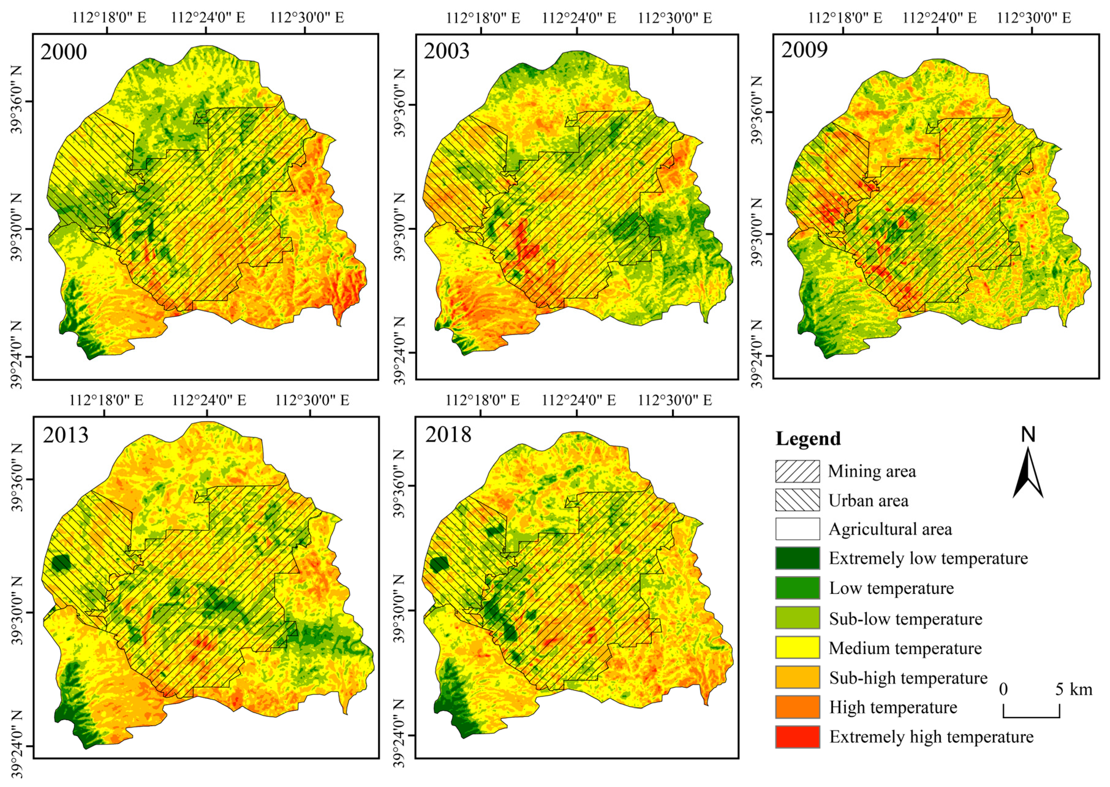
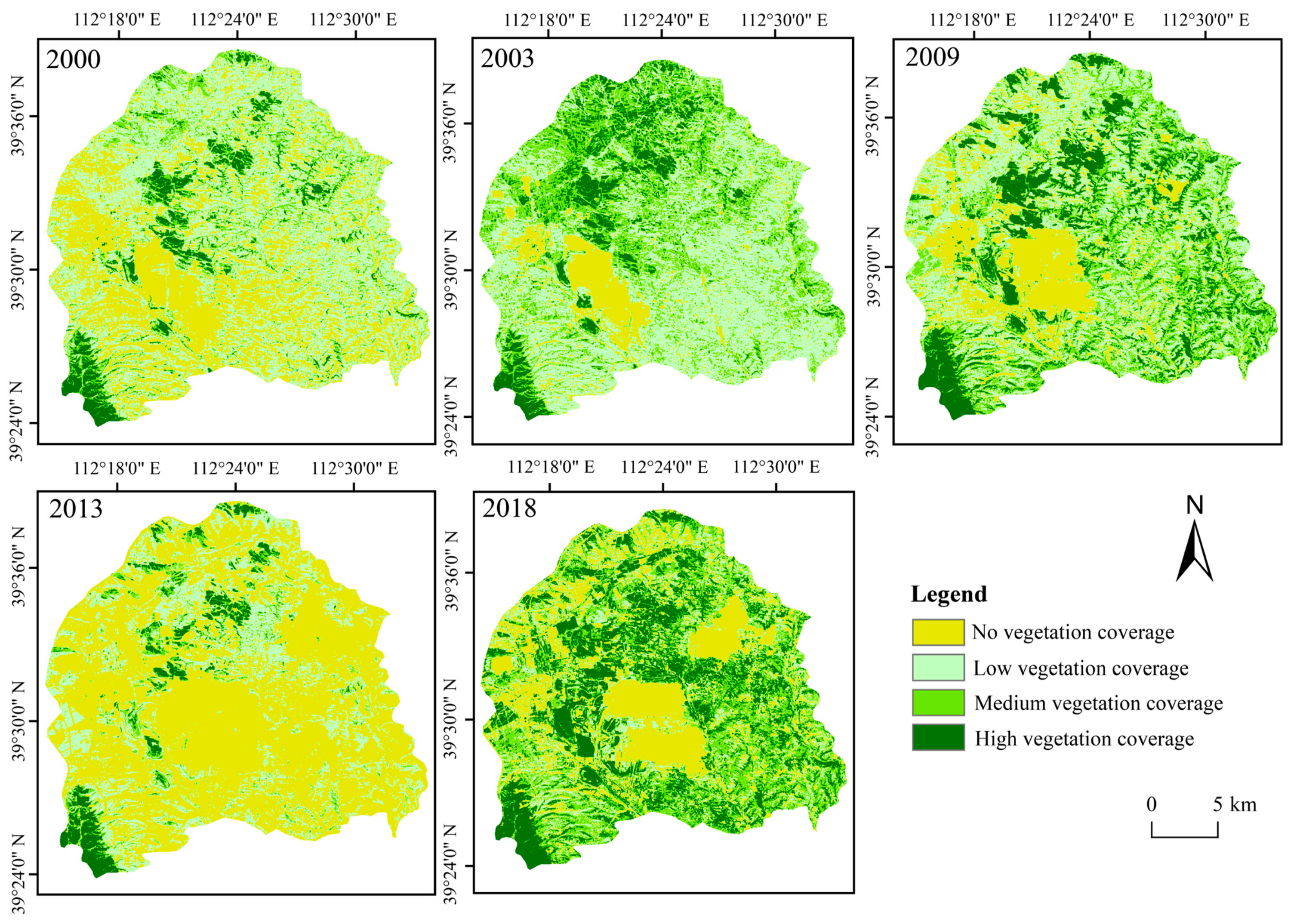
- The thermal effect zone is scattered and has irregular changes, while the non-thermal effect zone is basically maintained in areas with high vegetation coverage, water coverage or reclaimed coverage. The proportion of the thermal effect zone shows the same fluctuating rising trend as the average land surface temperature. According to the gravity center model of the thermal effect, the contributions of different functional areas to the overall thermal effect of the study area are in the order of agricultural area > mining area > urban area. However, urban land has tended to transform into the thermal effect zone in recent years, so the urban expansion mode and land use configuration should be reasonably controlled in the future.
- (2)
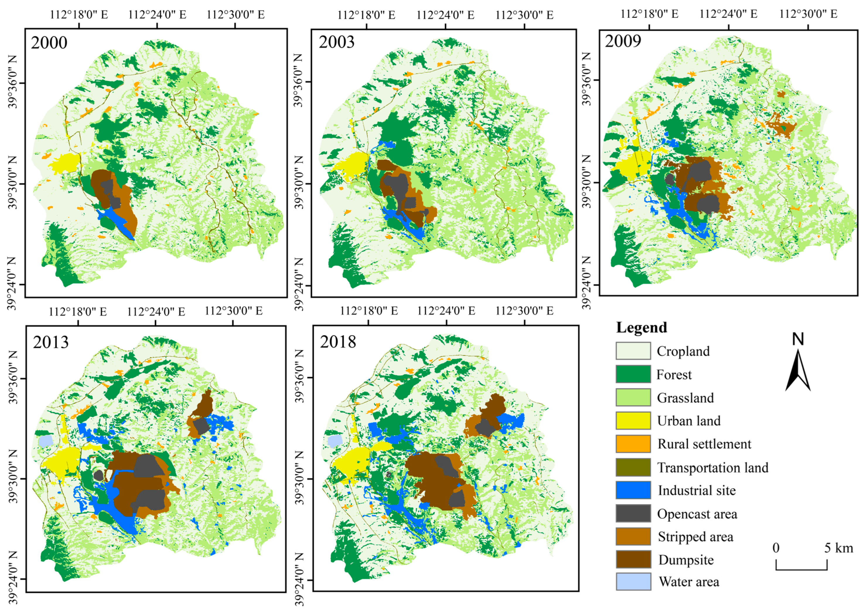
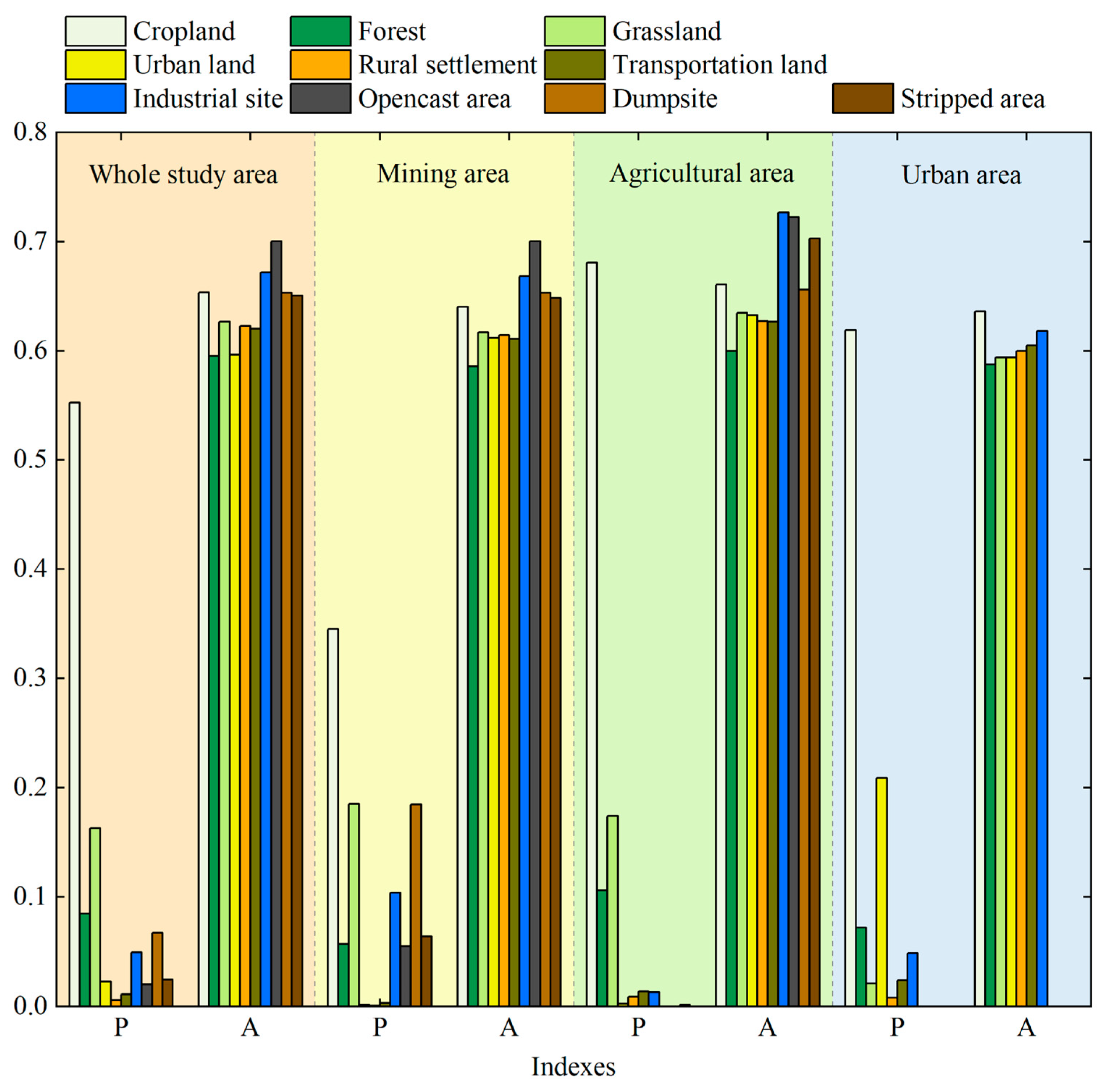
- The LST can be affected by land use types. The average grid temperature has significant correlations with the proportion of forest, grassland, opencast areas and dumpsites in different research scales. However, the proportion of forest and grid average temperature show a significant negative correlation with the highest correlation and the greatest influence. Thus, it is important to ameliorate the soil exposure status and improve vegetation coverage according to local conditions.
- (3)
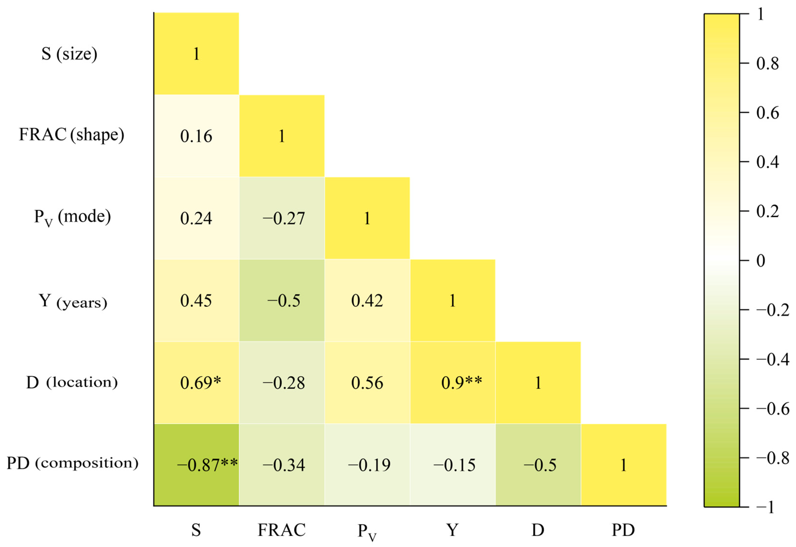
- Mining and reclamation influence the warming effect and cooling effect, respectively. In general, continuous work and regular monitoring of land reclamation are of great significance. Specifically, in future reclamation processes, it can be considered to plan the reclaimed site as a regular shape, select the reclamation mode of forest and grassland and try to reclaim as forests and grasslands near opencast areas and reclaim as croplands far away from the opencast area. Due to the influence of resource endowment and mining conditions, the boundary of opencast areas is blurred. Therefore, it is necessary to further quantify the influence of mining on the thermal environment in future.
Author Contributions
Funding
Institutional Review Board Statement
Informed Consent Statement
Data Availability Statement
Acknowledgments
Conflicts of Interest
References
- Liu, S.D.; Zhang, J.J.; Li, J.; Li, Y.Q.; Zhang, J.; Wu, X. Simulating and mitigating extreme urban heat island effects in a factory area based on machine learning. Build. Environ. 2021, 202, 108051. [Google Scholar] [CrossRef]
- Xie, M.M.; Bai, Z.K.; Fu, M.C.; Zhou, W.; Yuan, T. Effects of land disturbance on surface temperature in large opencast coal mine. J. China Coal Soc. 2011, 36, 643–647. [Google Scholar]
- Qiu, C.J.; Qu, L.; Sang, H.Y.; Zhang, X.H. Monitoring; measuring and analysis on urban heat island effect in resources type urban transformation process. Coal Eng. 2013, 45, 106–109. [Google Scholar]
- Rao, Y.H.; Xu, Y.; Zhang, J.J.; Guo, Y.Q.; Fu, M.C. Does subclassified industrial land have a characteristic impact on land surface temperatures? Evidence for and implications of coal and steel processing industries in a Chinese mining city. Ecol. Indic. 2018, 89, 22–34. [Google Scholar] [CrossRef]
- Cao, Y.G. Pattern Evolution and Management Countermeasures on Land Use in Typical Compound Area of Mine Agriculture Urban. Ph.D. Thesis, China University of Geoscience, Beijing, China, 5 June 2015. [Google Scholar]
- Li, X.M.; Zhou, W.Q.; Ouyang, Z.Y.; Xu, W.H.; Zheng, H. Spatial pattern of greenspace affects land surface temperature: Evidence from the heavily urbanized Beijing metropolitan area, China. Landsc. Ecol. 2012, 27, 887–898. [Google Scholar] [CrossRef]
- Zhang, Y.S.; Balzter, H.; Zou, C.C.; Xu, H.Q.; Tang, F. Characterizing bitemporal patterns of land surface temperature using landscape metrics based on sub-pixel classifications from Landsat TM/ETM+. Int. J. Appl. Earth Obs. 2015, 42, 87–96. [Google Scholar]
- Yue, H.; Liu, Y. Comparison and Analysis of Land Surface Temperature Retrieval Algorithms Based on Landsat 8 TIRS. Sci. Technol. Eng. 2018, 18, 200–205. [Google Scholar]
- Demirel, N.; Düzgün, Ş.; Emil, M.K. Land use change detection in a surface coal mine area using multitemporal high-resolution satellite images. Int. J. Min. Reclam. Environ. 2011, 25, 342–349. [Google Scholar] [CrossRef]
- Qin, Z.H.; Zhang, M.H.; Arnon, K.; Pedro, B. Mono-window algorithm for retrieving land surface temperature from Landsat TM6 data. Acta Geogr. Sin. 2001, 56, 456–466. [Google Scholar]
- Jimenez-Munoz, J.C.; Cristobal, J.; Sobrino, J.A.; Ninyerola, M.; Pons, X. Revision of the single-channel algorithm for land surface temperature retrieval from Landsat thermal-infrared data. IEEE Trans. Geosci. Remote Sens. 2009, 47, 339–349. [Google Scholar] [CrossRef]
- Rozenstein, O.; Qin, Z.H.; Derimian, Y.; Karnieli, A. Derivation of Land Surface Temperature for Landsat-8 TIRS Using a Split Window Algorithm. Sensors 2014, 14, 5768–5780. [Google Scholar] [CrossRef] [PubMed]
- Li, H.K.; Yang, L.; Lei, J. Comparison for retrieval algorithm of surface temperature in rare earth mining area based on Landsat-8 thermal infrared data. J. Chin. Soc. Rare Earths 2017, 35, 657–666. [Google Scholar]
- Hou, C.H.; Li, F.P.; Feng, Y.F.; Gu, H.H.; Yuan, X.T.; Song, W.; Liu, H.X. Analysis of differentiation effect of surface thermal environment in intensive mining areas based on NDVI-DFI model. Trans. Chin. Soc. Agric. Eng. 2020, 36, 160–168. [Google Scholar]
- Li, H.K.; Wu, G.H.; Wang, X.L. Land surface temperature downscaling method in ton-type rare earth mining area oriented to mining disturbance. Geomat. Inf. Sci. Wuhan Univ. 2021, 46, 133–142. [Google Scholar]
- Qiu, W.W.; Hou, H.P. Study on surface temperature variation caused by ecological disturbance in the mining area based on RS. Min. Res. Dev. 2013, 33, 68–71+83. [Google Scholar]
- Chen, Y.H.; Li, X.B.; Shi, P.J.; He, C.Y. Study on spatial pattern of urban heat environment in Shanghai city. Sci. Geogr. Sin. 2002, 22, 317–323. [Google Scholar]
- Qiao, Z.; Tian, G.J.; Zhang, L.X.; Xu, X.L. Influences of Urban Expansion on Urban Heat Island in Beijing during 1989–2010. Adv. Meteorol. 2014, 2014, 1–11. [Google Scholar] [CrossRef] [Green Version]
- Ge, R.F.; Wang, J.L.; Zhang, L.X.; Tian, G.J.; Feng, Y.Y. Impacts of urbanization on the urban thermal environment in Beijing. Acta Ecol. Sin. 2016, 36, 6040–6049. [Google Scholar]
- Joshi, P.K.; Punia, A. Thermal infrared imaging to identify surface mines. Mine Water Environ. 2019, 38, 700–704. [Google Scholar] [CrossRef]
- Li, J.; Miao, H.; Yang, Z.; Han, Y. Spatial variation of land surface temperature in Yanzhou coalfield. J. China Coal Soc. 2018, 43, 2595–2604. [Google Scholar]
- Wang, X.; Dai, X.A.; Chen, Y.J.; Xue, D.J. Analysis of ecological thermal environment effect in metal mining area towns. Sci. Technol. Eng. 2019, 19, 7–14. [Google Scholar]
- Zhuang, Y.; Xue, D.Q.; Wang, J. Spatial-temporal evolution of urban heat island in semiarid typical industrial city: A case of Baotou City. Arid Land Geogr. 2017, 40, 276–283. [Google Scholar]
- Xu, S.; Li, F.X.; Zhang, L.B.; Zhou, L. Spatiotemporal changes of thermal environment landscape pattern in Changsha. Acta Ecol. Sin. 2015, 35, 3743–3754. [Google Scholar]
- Wang, Y.B.; Zhao, Y.H.; Han, L.; Ao, Y.; Cai, J. Coupling relationship of landscape pattern and urban heat island effect in Xi’an, China. Chin. J. Appl. Ecol. 2017, 28, 2621–2628. [Google Scholar]
- Tang, Z.; Zheng, H.F.; Ren, Z.B.; Cui, M.X.; He, X.Y. Spatial and temporal changes to urban surface thermal landscape patterns: A case study of Changchun City. Acta Ecol. Sin. 2017, 37, 3264–3273. [Google Scholar]
- Cao, J.S.; Deng, Z.Y.; Li, W.; Hu, Y.D. Remote sensing inversion and spatial variation of land surface temperature over mining areas of Jixi, Heilongjiang, China. PeerJ 2020, 8, e10257. [Google Scholar] [CrossRef] [PubMed]
- Mao, C.C.; Xie, M.M.; Fu, M.C. Thermal response to patch characteristics and configurations of industrial and mining land in a Chinese mining city. Ecol. Indic. 2020, 112, 106075. [Google Scholar] [CrossRef]
- Xu, Y. A Relationship between Industrial/Mining Land Pattern and Island Heat Effect in a Mining City. Master’s Thesis, China University of Geoscience, Beijing, China, 1 June 2015. [Google Scholar]
- Feng, Y.Y.; Hu, T.G.; Zhang, L.X. Impacts of structure characteristics on the thermal environment effect of city parks. Acta Ecol. Sin. 2014, 34, 3179–3187. [Google Scholar]
- Sun, R.H.; Chen, A.L.; Chen, L.D.; Lü, Y.H. Cooling effects of wetlands in an urban region: The case of Beijing. Ecol. Indic. 2012, 20, 57–64. [Google Scholar] [CrossRef]
- Du, H.Y.; Song, X.J.; Jiang, H.; Kan, Z.H.; Wang, Z.B.; Cai, Y.L. Research on the cooling island effects of water body: A case study of Shanghai, China. Ecol. Indic. 2016, 67, 31–38. [Google Scholar] [CrossRef]
- Cai, Z.; Guldmann, J.M.; Tang, Y.; Han, G.F. Does city-water layout matter? Comparing the cooling effects of water bodies across 34 Chinese megacities. J. Environ. Manag. 2022, 324, 116263. [Google Scholar] [CrossRef]
- Wang, S.F.; Cao, Y.G.; Geng, B.J.; Yang, K.; Bai, Z.K. Succession law and model of reconstructed soil quality in an open-pit coal mine dump of the loess area, China. J. Environ. Manag. 2022, 312, 114923. [Google Scholar] [CrossRef]
- Wang, M.M.; Zhang, Z.J.; Hu, T.; Wang, G.Z.; He, G.J.; Zhang, Z.M.; Li, H.; Wu, Z.J.; Liu, X.G. An Efficient Framework for Producing Landsat-Based Land Surface Temperature Data Using Google Earth Engine. IEEE J. Sel. Top. Appl. Earth Obs. Remote Sens. 2020, 13, 4689–4701. [Google Scholar] [CrossRef]
- He, J.; Yang, K.; Tang, W.J.; Lu, H.; Qin, J.; Chen, Y.Y.; Li, X. The first high-resolution meteorological forcing dataset for land process studies over China. Sci. Data 2020, 7, 25. [Google Scholar] [CrossRef] [PubMed] [Green Version]
- Yang, Y.; He, J.; Tang, W.J.; Qin, J.; Cheng, C.C.K. On downward shortwave and longwave radiations over high altitude regions: Observation and modeling in the Tibetan Plateau. Agric. For. Meteorol. 2010, 150, 38–46. [Google Scholar] [CrossRef]
- Gutman, G.; Ignatov, A. The derivation of the green vegetation fraction from NO-AA/AVHRR data for use in numerical weather prediction models. Int. J. Remote Sens. 1998, 19, 1533–1543. [Google Scholar] [CrossRef]
- Qin, Z.H.; Li, W.J.; Zhang, M.H.; Arnon, K.; Pedro, B. Estimating of the essential atmospheric parameters of mono-window algorithm for land surface temperature retrieval from Landsat TM6. Remote Sens. Land Resour. 2003, 15, 37–43. [Google Scholar]
- Gong, S.Q.; Zhang, Q.R.; Wang, S.F.; Zhou, Y.; Zhang, S.Q.; Guo, W.Z. Study on the estimated model of effective mean atmospheric temperature for land surface temperature remote sensing. Remote Sens. Technol. Appl. 2015, 30, 1113–1121. [Google Scholar]
- Ren, X.M. Temperature Inspection System for Open-Air Coal Yard Based on UAVs. Master’s Thesis, Xi’an University of Science and Technology, Xi’an, China, 19 June 2017. [Google Scholar]
- Song, L.; Liu, S.J.; Yu, M.L.; Mao, Y.C.; Wu, L.X. A classification method based on the combination of visible; near-infrared and thermal infrared spectrum for coal and gangue distinguishment. Spectrosc. Spectr. Anal. 2017, 37, 416–422. [Google Scholar]
- Xia, J.; Tashpolat, T.; Zhang, F.; Cai, Z.Y.; Wei, J.; Ji, H.L. Thermal infrared emissivity spectrum and its characteristics of natural surface objects in coalfield fires area. J. China Coal Soc. 2012, 37, 2053–2059. [Google Scholar]
- Xiong, Y.; Zhang, F. Thermal environment effects of urban human settlements and influencing factors based on multi-source data: A case study of Changsha city. Acta Geogr. Sin. 2020, 75, 2443–2458. [Google Scholar]
- Mohamed, A.A.; Odindi, J.; Mutanga, O. Land surface temperature and emissivity estimation for Urban Heat Island assessment using medium-and low-resolution space-borne sensors: A review. Geocarto Int. 2017, 32, 455–470. [Google Scholar] [CrossRef]
- An, B.; Xiao, W.W.; Zhang, S.L.; Zhu, N.; Zhang, J.D. Spatial and temporal characteristics of surface temperature in the Loess Plateau during 1961–2017. Arid Land Geogr. 2021, 44, 778–785. [Google Scholar]
- Yue, P.; Zhang, Q.; Zhao, W.; Wang, R.Y.; Zhang, L.; Wang, W.Y.; Shi, J.S.; Hao, X.C. Influence of environmental factors on land-surface water and heat exchange during dry and wet periods in the growing season of semiarid grassland on the Loess Plateau. Sci. Sin. 2015, 45, 1229–1242. [Google Scholar] [CrossRef]
- Estoque, R.C.; Murayama, Y. Monitoring surface urban heat island formation in a tropical mountain city using Landsat data. ISPRS-J. Photogramm. Remote Sens. 2017, 133, 18–29. [Google Scholar] [CrossRef]
- Stemn, E.; Kumi-Boateng, B. Modelling of land surface temperature changes as determinant of urban heat island and risk of heat-related conditions in the Wassa West Mining Area of Ghana. Model. Earth Syst. Environ. 2020, 6, 1727–1740. [Google Scholar] [CrossRef]
- Ramdhani, N.F.; Sulistyawati, E.; Sutrisno, S. Land Surface Temperature Analysis of Post-Mining Area using Landsat 8 Imagery. In Proceedings of the Sixth International Symposium on LAPAN-IPB Satellite, Bogor, Indonesia, 24 December 2019. [Google Scholar]
- Liu, J. The Research to the Influential Factors of the Surface Temperature in Antaibao Opencast Coal Mine. Master’s Thesis, China University of Geoscience, Beijing, China, 5 June 2016. [Google Scholar]
- Xie, M.M.; Gao, S.T.; Li, S.L.; Zhou, Y.; Bai, Z.K.; Zhang, Y. Construction and spatiotemporal variation of dump reclamation disturbance index. Trans. Chin. Soc. Agric. Eng. 2019, 35, 258–265. [Google Scholar]
- Fan, X.; Song, Y.Z.; Zhu, C.X.; Balzter, H.; Bai, Z.K. Estimating Ecological Responses to Climatic Variability on Reclaimed and Unmined Lands Using Enhanced Vegetation Index. Remote Sens. 2021, 13, 1100. [Google Scholar] [CrossRef]
- Firozjaei, M.K.; Sedighi, A.; Firozjaei, H.K.; Kiavarz, M.; Homaee, M.; Arsanjani, J.J.; Makki, M.; Naimi, B.; Panah, S.K.A. A historical and future impact assessment of mining activities on surface biophysical characteristics change: A remote sensing-based approach. Ecol. Indic. 2021, 122, 107264. [Google Scholar] [CrossRef]
- Jamali, A.A.; Kalkhajeh, R.G.; Randhir, T.; He, S.T. Modeling relationship between land surface temperature anomaly and environmental factors using GEE and Giovanni. J. Environ. Manag. 2022, 302, 113970. [Google Scholar] [CrossRef]
- Dewan, A.; Kiselev, G.; Botje, D.; Mahmud, G.L.; Bhuian, M.H.; Hassan, Q.K. Surface urban heat island intensity in five major cities of Bangladesh: Patterns, drivers and trends. Sustain. Cities Soc. 2021, 71, 102926. [Google Scholar] [CrossRef]
- Cao, Y.G.; Bai, Z.K.; Sun, Q.; Zhou, W. Rural settlement changes in compound land use areas: Characteristics and reasons of changes in a mixed mining-Rural-Settlement area in Shanxi Province, China. Habitat Int. 2017, 61, 9–21. [Google Scholar] [CrossRef]
- Cao, Y.G.; Dallimer, M.; Stringer, L.C.; Bai, Z.K.; Siu, Y.L. Land expropriation compensation among multiple stakeholders in a mining area: Explaining “skeleton house” compensation. Land Use Pol. 2018, 74, 97–110. [Google Scholar] [CrossRef]
- Estoque, R.C.; Murayama, Y.; Myint, S.W. Effects of landscape composition and pattern on land surface temperature: An urban heat island study in the megacities of Southeast Asia. Sci. Total Environ. 2017, 577, 349–359. [Google Scholar] [CrossRef] [PubMed]
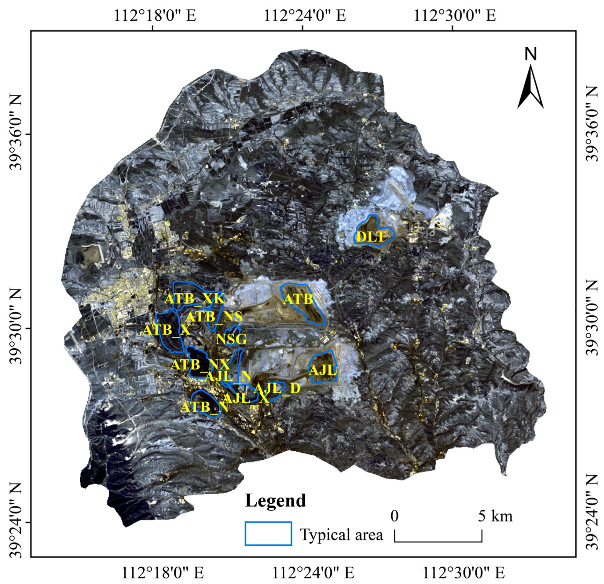


| Abbreviations | Meaning |
|---|---|
| DLT | Opencast in East open-pit mine |
| ATB | Opencast in Antaibao open-pit mine |
| AJL | Opencast in Anjialing open-pit mine |
| ATB_X | West dumpsite in Antaibao open-pit mine |
| ATB_N | South dumpsite in Antaibao open-pit mine |
| ATB_XK | West expansion dumpsite in Antaibao open-pit mine |
| ATB_NS | Upper internal dumpsite in Antaibao open-pit mine |
| ATB_NX | Lower internal dumpsite in Antaibao open-pit mine |
| NSG | Nansigou dumpsite in Antaibao open-pit mine |
| AJL_X | West dumpsite in Anjialing open-pit mine |
| AJL_N | Internal dumpsite in Anjialing open-pit mine |
| AJL_D | East dumpsite in Anjialing open-pit mine |
| Data Source | Date | Time (Hour: Minute) | Extent | Spatial Resolution (m) | Temporal Resolution (day) |
|---|---|---|---|---|---|
| Landsat 5 | 30 June 2000 | 10:48 10:49 | Path 126/Row32 and Path 126/Row 33 | 30/120 | 16 |
| 9 July 2003 | 10:48 10:48 | ||||
| 9 July 2009 | 11:00 11:01 | ||||
| Landsat 8 | 2 June 2013 | 11:14 11:14 | Path 126/Row32 and Path 126/Row 33 | 15/30/100 | |
| 31 May 2018 | 11:11 | Path 126/Row 33 |
| Thermal Environment Grade | Classification Standard |
|---|---|
| Extremely low temperature zone | T ≤ μ – 2.5 std |
| Low temperature zone | μ – 2.5 std < T ≤ μ – 1.5 std |
| Sub-low temperature zone | μ – 1.5 std < T ≤ μ – 0.5 std |
| Medium temperature zone | μ – 0.5 std < T ≤ μ + 0.5 std |
| Sub-high temperature zone | μ + 0.5 std < T ≤ μ + 1.5 std |
| High temperature zone | μ + 1.5 std < T ≤ μ + 2.5 std |
| Extremely high temperature zone | T > μ + 2.5 std |
| Functional Area | Land Use Types | R | Significance | Regression Equation |
|---|---|---|---|---|
| Whole study area | Forest | −0.641 | 0.000 | y = −0.057x + 40.291 |
| Grassland | 0.231 | 0.021 | y = 0.021x + 38.914 | |
| Mining area | Forest | −0.685 | 0.000 | y = −0.059x + 40.061 |
| Opencast area | 0.325 | 0.028 | y = 0.039x + 38.890 | |
| Dumpsite | 0.380 | 0.009 | y = 0.022x + 38.749 | |
| Water area | −0.400 | 0.006 | y = −1.669x + 39.254 | |
| Agricultural area | Forest | −0.681 | 0.000 | y = −0.063x + 40.867 |
| Grassland | 0.452 | 0.002 | y = 0.034x + 39.114 | |
| Urban area | Forest | −0.679 | 0.044 | y = −0.030x + 36.662 |
| Symbols | Feature | Index |
|---|---|---|
| S | Size | Reclamation area |
| FRAC | Shape | Fractal dimension index |
| PV | Reclamation mode | Vegetation coverage |
| Y | Reclamation term | The year since the beginning of reclamation |
| D | Spatial location | The distance between the gravity center of the temperature of each typical area and the gravity center of thermal effect zone of the mining area |
| PD | Composition of land use types around reclaimed site | The percentage of adjacent damaged land (including dumpsite and industrial site) |
| Parameters | Feature | Tm | L | ∆T | I |
|---|---|---|---|---|---|
| PV | Reclamation mode | −0.929 ** | −0.539 | 0.690 * | 0.515 |
| Y | Reclamation years | −0.270 | 0.199 | 0.754 * | −0.149 |
| S | Size | −0.396 | 0.436 | 0.188 | −0.339 |
| FRAC | Shape | 0.233 | 0.377 | −0.638 * | −0.485 |
| D | Spatial location | −0.457 | 0.167 | 0.737 * | −0.146 |
| PD | Composition of land use types around reclaimed site | 0.363 | −0.289 | −0.105 | 0.234 |
| Y | X | Feature | R2 | Significance | Regression Equation |
|---|---|---|---|---|---|
| Tm | PV | Reclamation mode | 0.845 | 0.000 | |
| ∆T | PV | Reclamation mode | 0.459 | 0.019 | |
| FRAC | Shape | 0.333 | 0.047 | ||
| D | Spatial location | 0.761 | 0.003 |
Disclaimer/Publisher’s Note: The statements, opinions and data contained in all publications are solely those of the individual author(s) and contributor(s) and not of MDPI and/or the editor(s). MDPI and/or the editor(s) disclaim responsibility for any injury to people or property resulting from any ideas, methods, instructions or products referred to in the content. |
© 2023 by the authors. Licensee MDPI, Basel, Switzerland. This article is an open access article distributed under the terms and conditions of the Creative Commons Attribution (CC BY) license (https://creativecommons.org/licenses/by/4.0/).
Share and Cite
Liu, S.; Wang, D.; Cao, Y. Characteristics of the Thermal Environment and its Guidance to Ecological Restoration in a Resource-Based Area in the Loess Area. Int. J. Environ. Res. Public Health 2023, 20, 3650. https://doi.org/10.3390/ijerph20043650
Liu S, Wang D, Cao Y. Characteristics of the Thermal Environment and its Guidance to Ecological Restoration in a Resource-Based Area in the Loess Area. International Journal of Environmental Research and Public Health. 2023; 20(4):3650. https://doi.org/10.3390/ijerph20043650
Chicago/Turabian StyleLiu, Shihan, Dandan Wang, and Yingui Cao. 2023. "Characteristics of the Thermal Environment and its Guidance to Ecological Restoration in a Resource-Based Area in the Loess Area" International Journal of Environmental Research and Public Health 20, no. 4: 3650. https://doi.org/10.3390/ijerph20043650
APA StyleLiu, S., Wang, D., & Cao, Y. (2023). Characteristics of the Thermal Environment and its Guidance to Ecological Restoration in a Resource-Based Area in the Loess Area. International Journal of Environmental Research and Public Health, 20(4), 3650. https://doi.org/10.3390/ijerph20043650


