Article

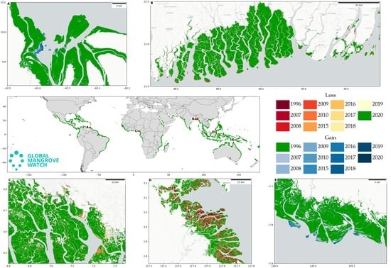
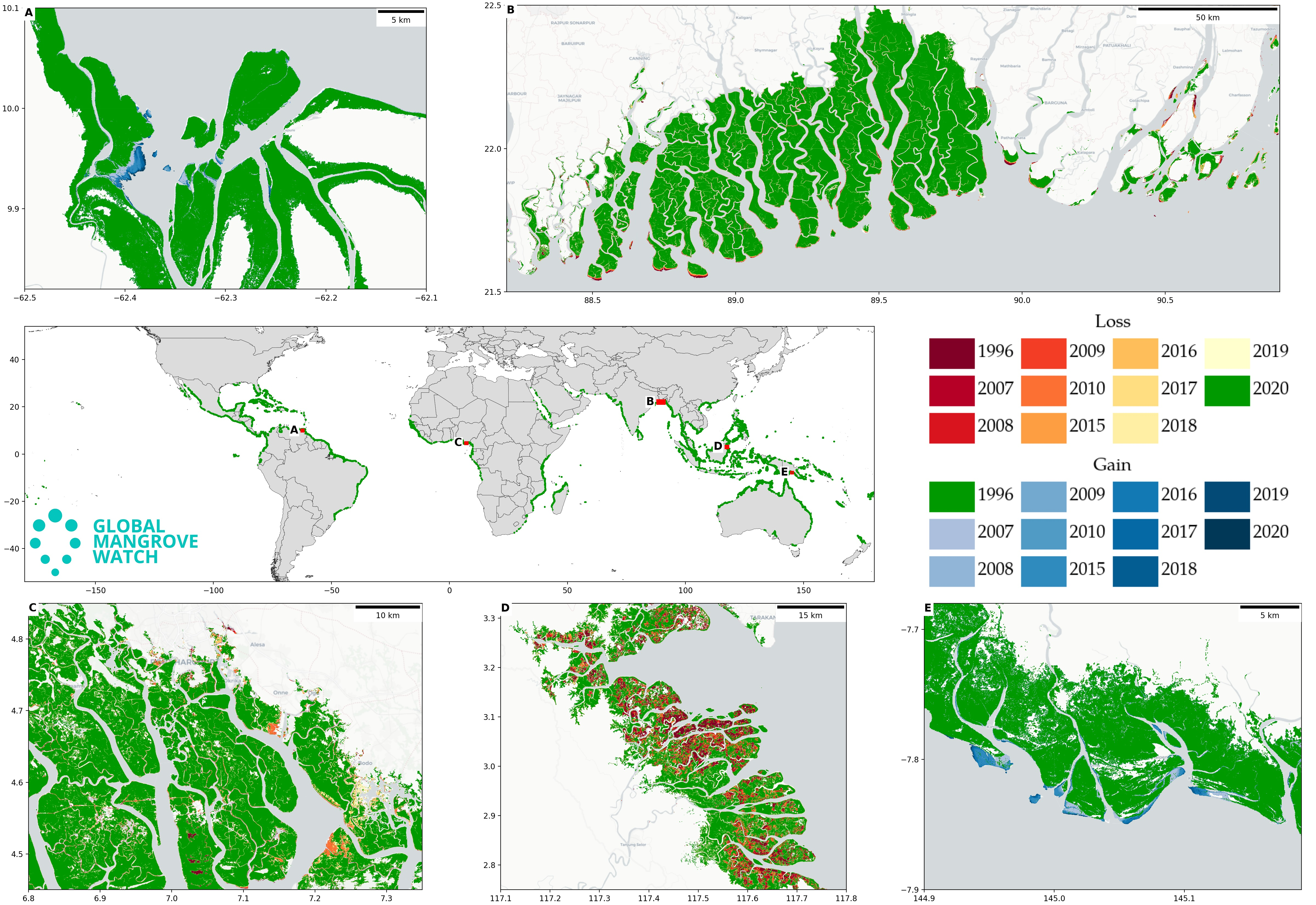
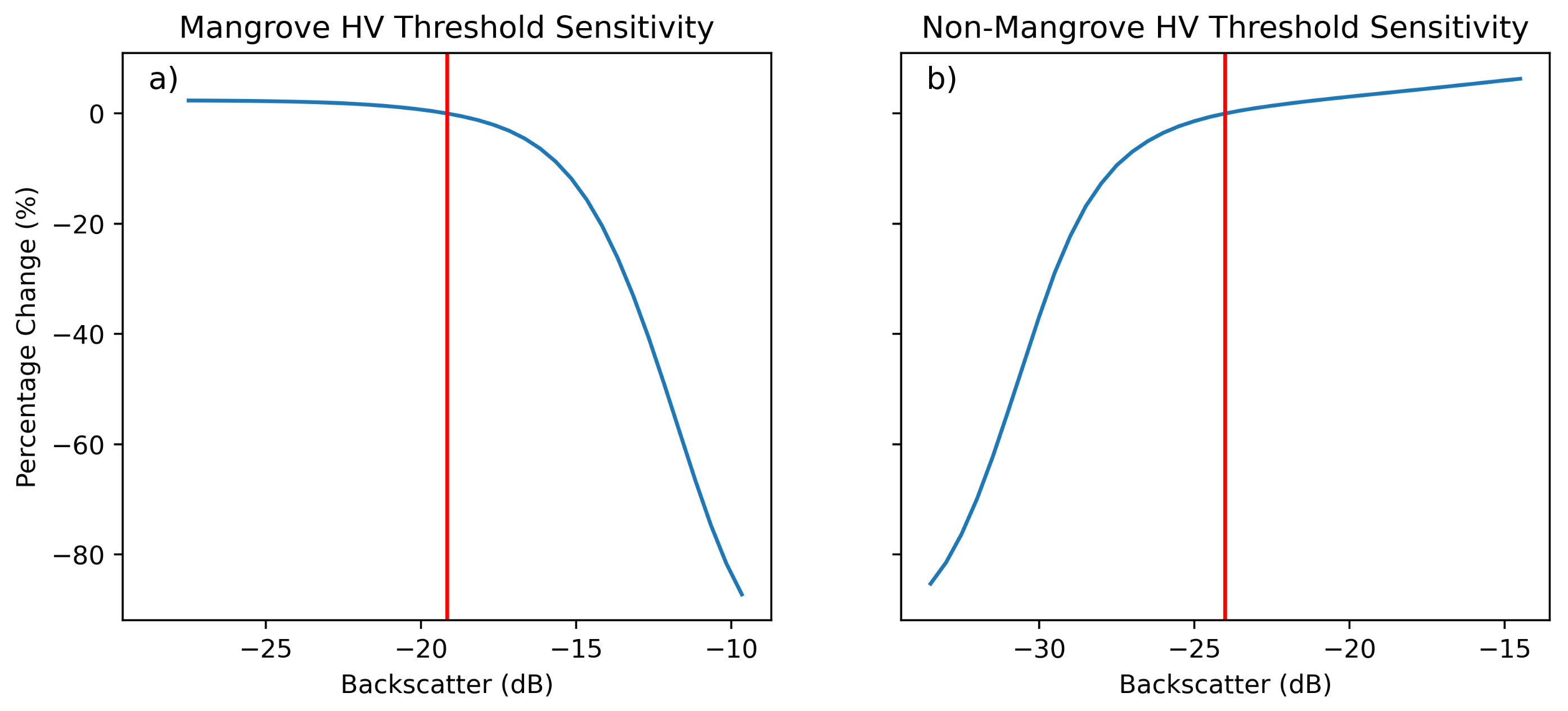
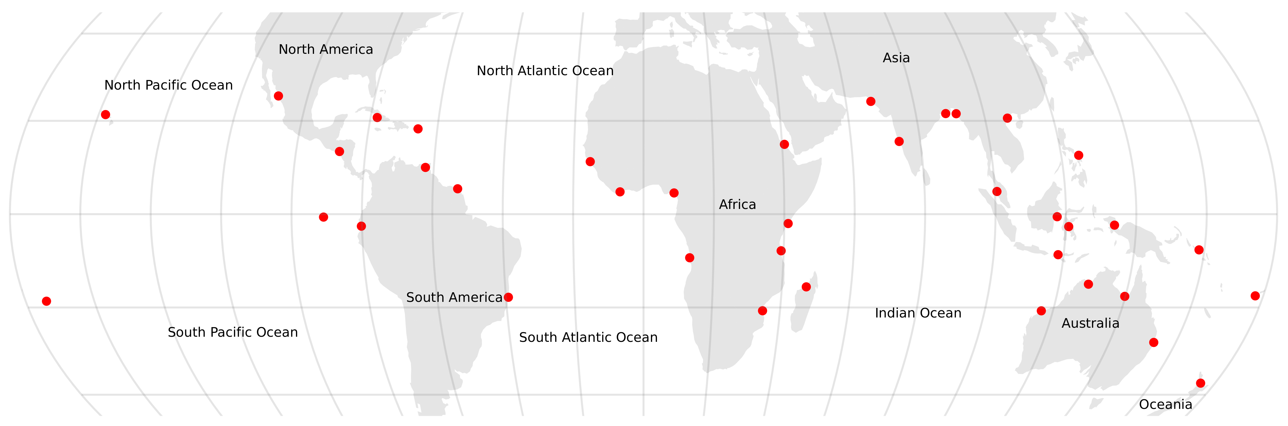
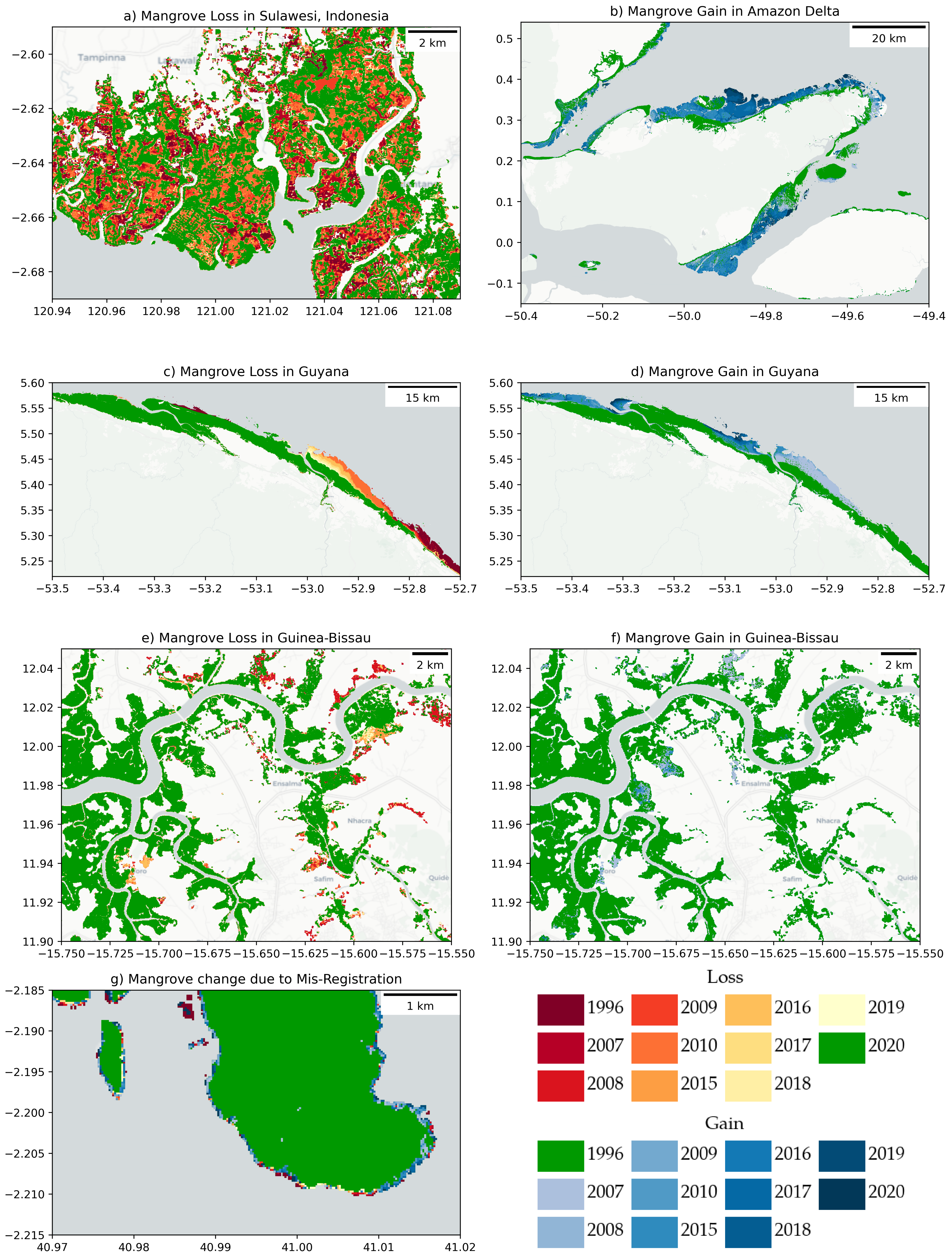
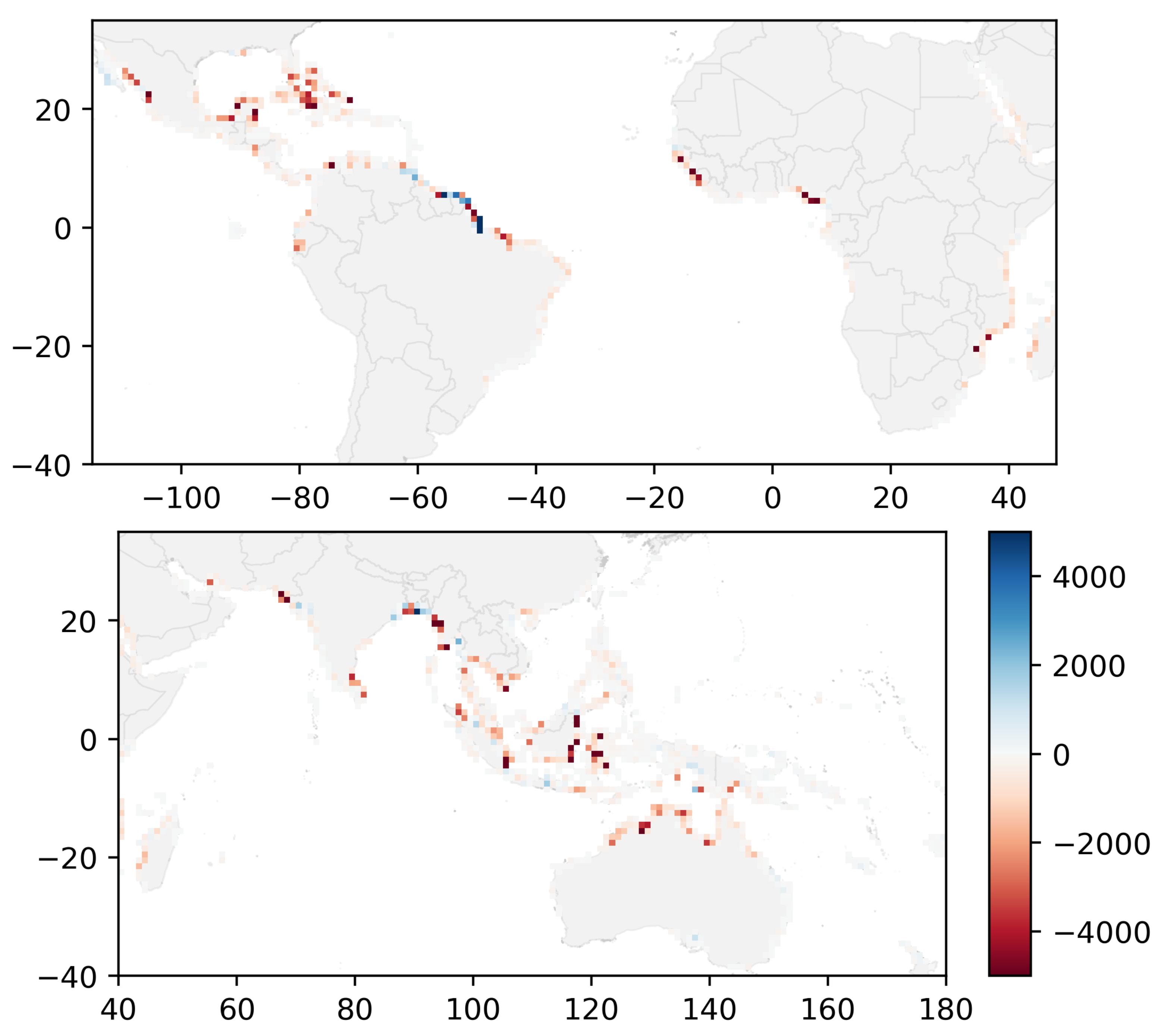
Global Mangrove Extent Change 1996–2020: Global Mangrove Watch Version 3.0

1
Department Geography and Earth Sciences, Aberystwyth University, Aberystwyth SY23 3DB, UK
2
solo Earth Observation (soloEO), Tokyo 104-0054, Japan
3
Wetlands International, 6700AL Wageningen, The Netherlands
4
Earth System Science Interdisciplinary Research Center (ESSIC), University of Maryland, College Park, MD 20740, USA
5
Biospheric Sciences, NASA Goddard Space Flight Center, Greenbelt, MD 20771, USA
6
Earth Observation Research Center, Japan Aerospace Exploration Agency, Tsukuba 305-8505, Japan
7
Department of Zoology, University of Cambridge, The David Attenborough Building, Pembroke Street, Cambridge CB2 3QZ, UK
8
The Nature Conservancy, 53100 Siena, Italy
9
College of Science and Engineering, James Cook University, Townsville, QLD 4811, Australia
10
International Water Management Institute, 127 Sunil Mawatha, Colombo P.O. Box 2075, Sri Lanka
*
Author to whom correspondence should be addressed.
Remote Sens. 2022, 14(15), 3657; https://doi.org/10.3390/rs14153657
Submission received: 8 July 2022 / Revised: 25 July 2022 / Accepted: 26 July 2022 / Published: 30 July 2022
(This article belongs to the Special Issue Advances in Remote Sensing of Land-Sea Ecosystems)

Abstract

Mangroves are a globally important ecosystem that provides a wide range of ecosystem system services, such as carbon capture and storage, coastal protection and fisheries enhancement. Mangroves have significantly reduced in global extent over the last 50 years, primarily as a result of deforestation caused by the expansion of agriculture and aquaculture in coastal environments. However, a limited number of studies have attempted to estimate changes in global mangrove extent, particularly into the 1990s, despite much of the loss in mangrove extent occurring pre-2000. This study has used L-band Synthetic Aperture Radar (SAR) global mosaic datasets from the Japan Aerospace Exploration Agency (JAXA) for 11 epochs from 1996 to 2020 to develop a long-term time-series of global mangrove extent and change. The study used a map-to-image approach to change detection where the baseline map (GMW v2.5) was updated using thresholding and a contextual mangrove change mask. This approach was applied between all image-date pairs producing 10 maps for each epoch, which were summarised to produce the global mangrove time-series. The resulting mangrove extent maps had an estimated accuracy of 87.4% (95th conf. int.: 86.2–88.6%), although the accuracies of the individual gain and loss change classes were lower at 58.1% (52.4–63.9%) and 60.6% (56.1–64.8%), respectively. Sources of error included misregistration in the SAR mosaic datasets, which could only be partially corrected for, but also confusion in fragmented areas of mangroves, such as around aquaculture ponds. Overall, 152,604 km2 (133,996–176,910) of mangroves were identified for 1996, with this decreasing by −5245 km2 (−13,587–1444) resulting in a total extent of 147,359 km2 (127,925–168,895) in 2020, and representing an estimated loss of 3.4% over the 24-year time period. The Global Mangrove Watch Version 3.0 represents the most comprehensive record of global mangrove change achieved to date and is expected to support a wide range of activities, including the ongoing monitoring of the global coastal environment, defining and assessments of progress toward conservation targets, protected area planning and risk assessments of mangrove ecosystems worldwide.
Keywords: mangrove; change; extent; Global Mangrove Watch; L-band; SAR; change detection mangrove; change; extent; Global Mangrove Watch; L-band; SAR; change detection
Graphical Abstract

