Abstract
Melbourne’s Chinatown is the oldest in Australia. A large amount of research on this unique ethnic enclave has been conducted to elucidate its formation history, heritage significance, cultural influence and architectural features. However, the discussion of the precinct’s spatial characteristics remains mostly marginalised. As a heritage precinct in the centre of an urban grid form, the precinct offers a unique spatial experience to its visitors. To better fathom the street layout of the area, three objectives are addressed in this study, including understanding: (1) the precinct’s street network in the grid system, (2) the visibility relationship within the precinct and (3) the relationship between buildings and streets. A joint methodology framework is established to fulfil the research objectives by incorporating space syntax methods and field observation. The findings facilitate policymakers and planners in understanding the precinct’s unique street layout and making relevant preservation decisions. Further studies are encouraged to scrutinise other spatial and urban characteristics of the precinct and test the proposed methodology.
1. Introduction
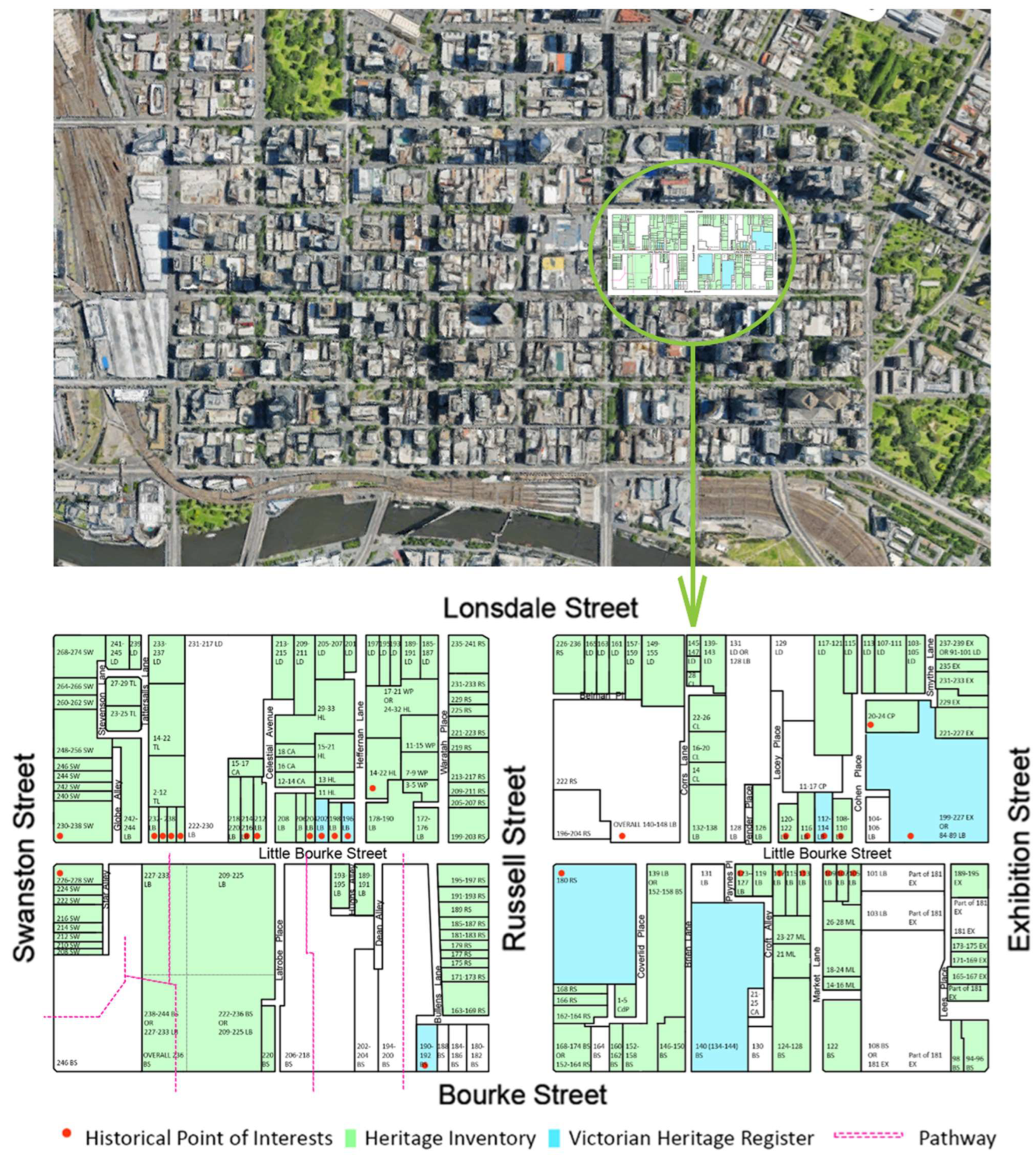
Chinatown is often regarded as a settlement or an ethnic enclave for Chinese migrants. In Australia, the history of Chinatown can be traced back to the gold rush period in the 1850s, when many Chinese gold seekers arrived and resided in major cities such as Melbourne [1]. As the oldest in Australia, Melbourne’s Chinatown is located on Little Bourke Street in the city centre. As seen in Figure 1, the boundaries of Melbourne’s Chinatown precinct are formed by Swanston, Lonsdale, Exhibition and Bourke Streets. The Victorian Heritage Register identifies three levels of protection from the state level (highest level of heritage significance) to a local level, namely the Victorian Heritage Register, Heritage Inventory and Heritage Overlay [2]. As depicted in Figure 1, most of the urban fabric within Melbourne’s Chinatown is recognised with heritage significance by Heritage Victoria, which establishes the precinct as a key urban heritage site in the centre of Melbourne. Anyone can nominate a place to be a part of the Victorian Heritage Register. The nominated places are evaluated using the Heritage Council’s assessment criteria to examine their importance to the history and development of the State. For a place to be considered, at least one out of eight criteria must be met, including:
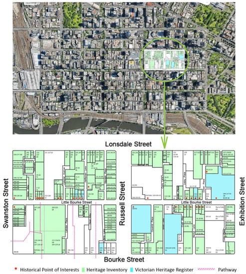
Figure 1.
Map of Chinatown drawn by author [3].
- Importance to the course, or pattern, of Victoria’s cultural history;
- Possession of uncommon, rare or endangered aspects of Victoria’s cultural history;
- Potential to yield information that will contribute to an understanding of Victoria’s cultural history;
- Importance in demonstrating the principal characteristics of a class of cultural places and objects;
- Importance in exhibiting particular aesthetic characteristics;
- Importance in demonstrating a high degree of creative or technical achievement at a particular period;
- Strong or special association with a particular present-day community or cultural group for social, cultural or spiritual reasons;
- Special association with the life or works of a person, or group of persons, of importance in Victoria’s history.
Places not meeting the state-level criteria by the Heritage Council of Victoria may be qualified as locally significant (Heritage Overlay).
As a key ethnic enclave with rich heritage value, a large volume of qualitative research can be acquired on associated topics such as the migration history of Chinese ethnic groups in Australia [4,5,6,7,8,9]. As a heritage precinct situated in the grid form of Melbourne’s city centre, it offers a unique spatial experience to visitors. However, the discussion of the spatial and urban characteristics of the area that constitutes such an experience has primarily remained marginalised. Only a few existing studies have addressed elements of the area’s spatial and urban characteristics, such as critical zoning [10], socio-economic features [11] and Chinese urban and architectural influences [12,13,14,15,16,17,18,19]. The lack of understanding of the precinct’s street network and its interaction with the grid system is inevitable. As the precinct currently serves as an urban heritage tourist attraction under the Victorian Heritage Register, spatial features and the subsequent experiences for visitors are critical aspects to consider. To better serve the precinct as an urban heritage attraction, the street network in the grid system and the relationship between buildings and streets on the ground level become crucial factors to understand. These factors can directly impact the visitor’s experience in the precinct, which involves mostly ground-level interactions. To enrich the spatial understanding of this heritage precinct and its spatial interaction with visitors, the study also aims to examine the visibility of spaces within the precinct. Therefore, this study postulates three key research objectives:
- Understanding the street network of Melbourne’s Chinatown in the existing grid system;
- Examining the visibility relationship within the precinct;
- Understanding the relationship between buildings and streets within the precinct.
With the understanding of these above-mentioned spatial characteristics, the study aims to broaden the current urban morphological analysis around Melbourne’s Chinatown and provide suggestions to enhance the ground-level visitor spatial interaction within the precinct, serving as a crucial urban heritage in the city’s grid network. Currently, the concept of cultural sustainability is addressed as the fourth pillar of sustainability among economic, environmental and social sustainability [20,21]. In the heritage discipline, the concept often emphasises retaining and improving the cultural significance and place identity of heritage sites. Fathoming the above-mentioned spatial characteristics can also benefit the preservation of the current urban identity and enhance cultural sustainability as an urban heritage precinct.
To fulfil the research objectives, this study incorporates space syntax methods with field observation to gain both qualitative and quantitative evidence. A joint methodological framework is developed to better provide insights into the objectives [22,23]. Space syntax deviates from classical urban morphology because it utilises an open space system to practice a form of spatial representation [24]. The juxtaposition of space syntax methods and heritage-related questions has an enduring history, mainly in evaluating the spatial characteristics and exploring the sociocultural dimensions embedded in spatial systems of historical significance [25,26,27,28,29,30,31,32,33,34,35,36,37]. A literature review by Palaiologou and Griffiths (2019) explicates three case study scales in research papers evolving space syntax and heritage study, including monumental urban spaces, non-monumental but protected by planning law and lived/emergent historical urban areas [38]. This study corresponds to the second type of urban heritage scrutinised by Palaiologou and Griffiths (2019). To facilitate further testing of the methodological framework of this study, this study categorises the objectives and the subsequent multidimensional methods into four scales, including macro, semi-urban, micro and human scale. Following the methodology and findings, discussions and recommendations can ultimately assist with preserving the precinct as a key urban heritage site in Australia. Further studies are encouraged to use the proposed transferable methodology in examining other urban heritage sites from other cultures.
2. Materials and Methods
This study incorporates spatial analyses on four scales, including three existing space syntax analyses and field observation as joint methods [39,40,41]. To enrich the comprehensiveness of space syntax results, the field observation method is utilised. Parameters of each space syntax are selected to suit the three research objectives. Table 1 provides an overview of the variables in each step of the proposed methodological framework [39,40,41].

Table 1.
Methodology of the study.
2.1. Human-Scale: Field Observation
The 1985 Chinatown Action Plan plays a vital role in the planning of the precinct, as most of the proposed principles were realised from 1985 to 1988 while still being practised today [3]. These principles provide suggestions on a range of urban elements within the enclave, including the main street, sidewalk, laneway and open space. As new developments have been erected in the past 36 years, features of the precinct have unavoidable modifications. Based on the key elements listed in the Chinatown Action Plan and the objectives to further understand the precinct’s street layout, the field observation is conducted to unveil the context of the case study, human perceptions of the urban complex and to compensate for the potential singularity of space syntax results [42,43]. The focus of the field observation also aligns with the key measurements in the previous three steps (Table 1), mainly focusing on the spatial features from an experiential perspective, including accessibility, visibility, step depth and the use of main streets and laneways. Field observation was conducted in April 2022 to collect qualitative data using field notes and photographs. Observation points are scattered along the main streets and the laneways within the precinct. As the occupancy of dwellings in the area changes frequently, the results from field observation only reflect the uses of dwellings in April 2022. With the lack of official records and frequent changes, findings from this tactic may vary in the future. Photographic sequences and cartography evidence are included to showcase findings from this tactic.
2.2. Macro-Scale: Space Syntax Axial Analysis
The axial analysis was developed based on the space syntax theory by Hillier and Hanson [24,41]. It is often performed to assess the spatial layout represented as an axial map, commonly extracted from urban maps or architectural floor plans. In this study, four key measurements are utilised to attain the macro-scale street characteristics of Melbourne’s Chinatown and how it fits in the existing grid system. Table 2 summarises the four measurements, including connectivity, mean depth, axial integration and intelligibility [41,44,45,46]. Table 2 can benefit future studies with clear identification of the formulas and interpretation of space syntax parameters with respect to the original space syntax methodologies, which are often absent in existing research. Depth map X is used to aid the data extraction, the analysis process and visualisation. Only streets within Chinatown are presented in the space syntax result tables to resonate with the study’s scope. However, for the macro-scale analysis, the entire Melbourne CBD is considered in assessing and interpreting the data in Depthmap X. Streets in the precinct are categorised into three types, a, b and c, denoting laneways, north to south main streets and east to west main streets. Twenty-three ‘type a’ streets are recorded, while six main streets are classified as ‘type b or c’.
2.3. Semi-Urban Scale: Space Syntax VGA (Visibility Relationship within the Precinct)
VGA is commonly executed to examine the visibility relationship between spaces on a semi-urban scale [47,48]. This study uses VGA to test the visibility relationships within the precinct from five key entrances along Little Bourke Street, in order to examine the visibility relationship within the precinct, which is critical as the precinct now acts as an urban heritage serving visitors who are not familiar with the area. This study employs five key VGA measurements, including isovist area, visual integration, visual step depth, metric step depth and angular step depth (Table 3). Further to an existing study by Xu et al. (2020), this study incorporates further analyses on two scales to obtain an in-depth understanding [49].

Table 2.
Formulas and spatial characteristics within space syntax axial analysis [24,39,41,44,45,46,49].
Table 2.
Formulas and spatial characteristics within space syntax axial analysis [24,39,41,44,45,46,49].
| Name of Axial Measure | Mathematical Formula | Explanatory Notes | Spatial Characteristics Interpretation |
|---|---|---|---|
| Connectivity ) | Connectivity defines the configurations of local structures in street networks; where is the number of axial lines connected to the i-th axial line. | A street with a high connectivity value has many connections to its side streets, whereas a low connectivity value represents few connections. | |
| Mean Depth Total Depth | Mean Depth represents the average distance of the i-th axial line from all the other n-1 axial lines. For two open spaces, and , which are said to be at depth (least syntactic steps needed to reach one vertex from the other), represents the sum of all depths from a given origin. | A system with a high total depth value is often described as a ‘deep’ system, where more spaces are passed through from a chosen starting point in the system (more steps). Based on total depth, mean depth reflects the average distance of any two points within the system. | |
| Axial Integration | Integration represents the degree to which i-th vertex is integrated or segregated from an urban system as a whole (global integration ) or from a partial system within certain steps away from the i-th vertex (local integration). In most cases, three syntactic steps (radius of three) represent the walking scale within an urban system (local integration R3). is real asymmetry is real relative asymmetry ‘Diamond’ D-Value is used to normalise graphs that represent architectural or urban spaces. | A street with high integration means the degree of accessibility this street has to all other streets in the system is high, fewer direction changes (syntactic steps) are needed. Global integration reflects the accessibility at a radius of n (n syntactic steps). Local integration reflects the accessibility at a radius of three (three syntactic steps). | |
| Intelligibility describes the correlation between connectivity and global integration . is the average of all the connectivity value. is the average of all the global integration value. | Intelligibility measures if the local spatial structure (number of immediate connections) can help comprehend the entire spatial system (how correlated are the connectivity and global integration). |

Table 3.
A table of VGA parameters [35,41,46].
Table 3.
A table of VGA parameters [35,41,46].
| VGA Variable | Definition |
|---|---|
| Isovist Area | Isovist area represents the area of all space visible from a subject point in the plan. |
| Visual Integration | Visual integration measures the visual distance from all spaces to all others. It tells you how visually connected all spaces are in the footprint. |
| Visual Step Depth (from five identified view points) | Derived from the definition of Step Depth, visual step depth measures how many ‘steps’ it takes to cover the entire area, where the ‘steps’ are measured by how far you can see. |
| Metric Depth (from five identified view points) | The metric depth to location at any point in the plan is the shortest metric path distance from said point to a single universal sample location. |
| Angular Step Depth (from five identified view points) | The angular depth to location at any point in the plan is the lowest angular variation in heading accumulated along any path from said point to a single universal sample location. |
2.4. Micro-Scale: Spatial Relationships between Buildings and Streets
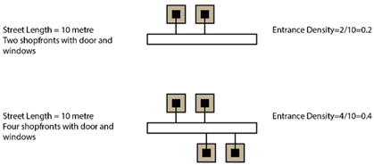
By addressing the entrance density, constitutedness and intervisibility, this study is the first to analyse Melbourne’s Chinatown from the perspective of private–public spatial relationships. Van Nes and Yamu (2021) suggest that the micro-scale urban spatial analyses mentioned above are quantifications derived from Jane Jacob’s and Jan Gehl’s presumptions about the interrelation between streets, building entrances and windows [39,40,50,51,52]. In their view, achieving urban liveliness necessitates many entrances and windows facing the streets. Urban liveliness determined through the density, depth, permeability and visibility of entrances along streets can envisage the natural surveillance, street safety and relationship between crime and space of an urban fabric.
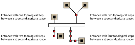
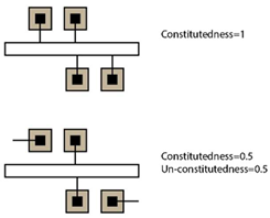
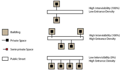
Based on this theory, scholars affirm that by studying the street network’s spatial structure and the interrelation between buildings and adjacent street segments, one can understand micro-scale urban spatial relationships between private and public spaces [40,50]. Later, several measurements were developed and tested to address how building openings are connected to the street network, the degree of topological depth from private space to public space and the intervisibility between entrances and windows. Key measurements include entrance density, street constitutedness, street intervisibility, and topological depth between private and public street spaces [24,40,50,53,54]. Measurements derived from this tactic are developed mainly to quantify spatial parameters for the building–street interface and how to present degrees of active frontage. Table 4 summarises these variables and their diagrammatic explanations. Field observation is essential in identifying each street’s entrances and private–public topological relationships. Van Nes and Yamu (2021) identified some limitations of the urban micro-scale methods, including the difference between urban liveliness during day and night [39]. They recommend further research to use these methods in case studies with different cultural backgrounds, which is piloted in this study with Melbourne’s Chinatown.

Table 4.
Definition and spatial characteristics within public–private spatial relationship analysis [39,40,41,50].
3. Results
The following section will present the findings from the space syntax analysis and the field observations. Findings from the first observation (Section 3.1) are first presented to portray the overall visual of Melbourne’s Chinatown. Results from the axial analysis (Section 3.2) mainly addressed the first objective, which is to understand the street network of the precinct in an urban grid system. Parameters within the axial analysis include connectivity, integration, and intelligibility. The VGA analysis results (Section 3.3) address the visibility relationships within the precinct. Section 3.4 delves into the relationship between the buildings and streets on the ground level. Together, the result sections showcase more understanding of the street layout of Melbourne’s Chinatown in an existing urban grid to better serve the precinct as an urban heritage attraction.
3.1. Results from Field Observation
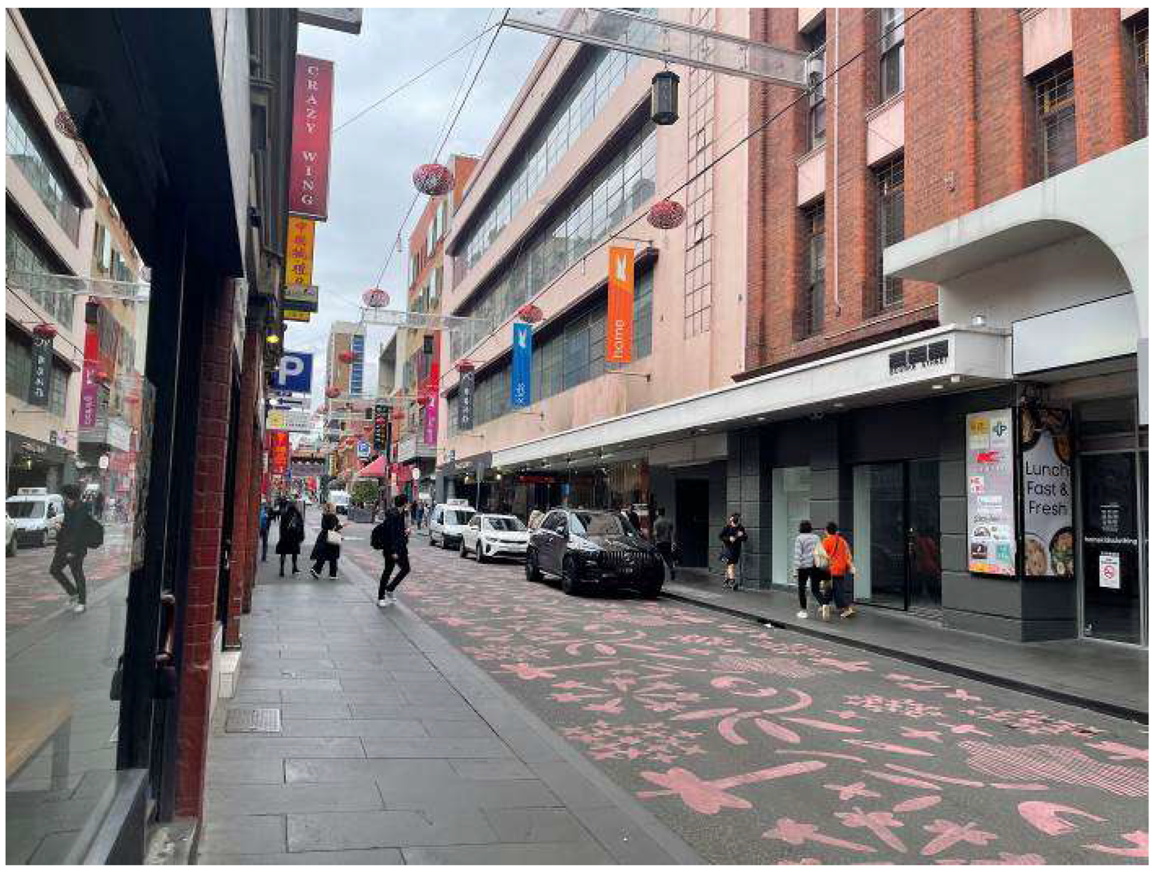
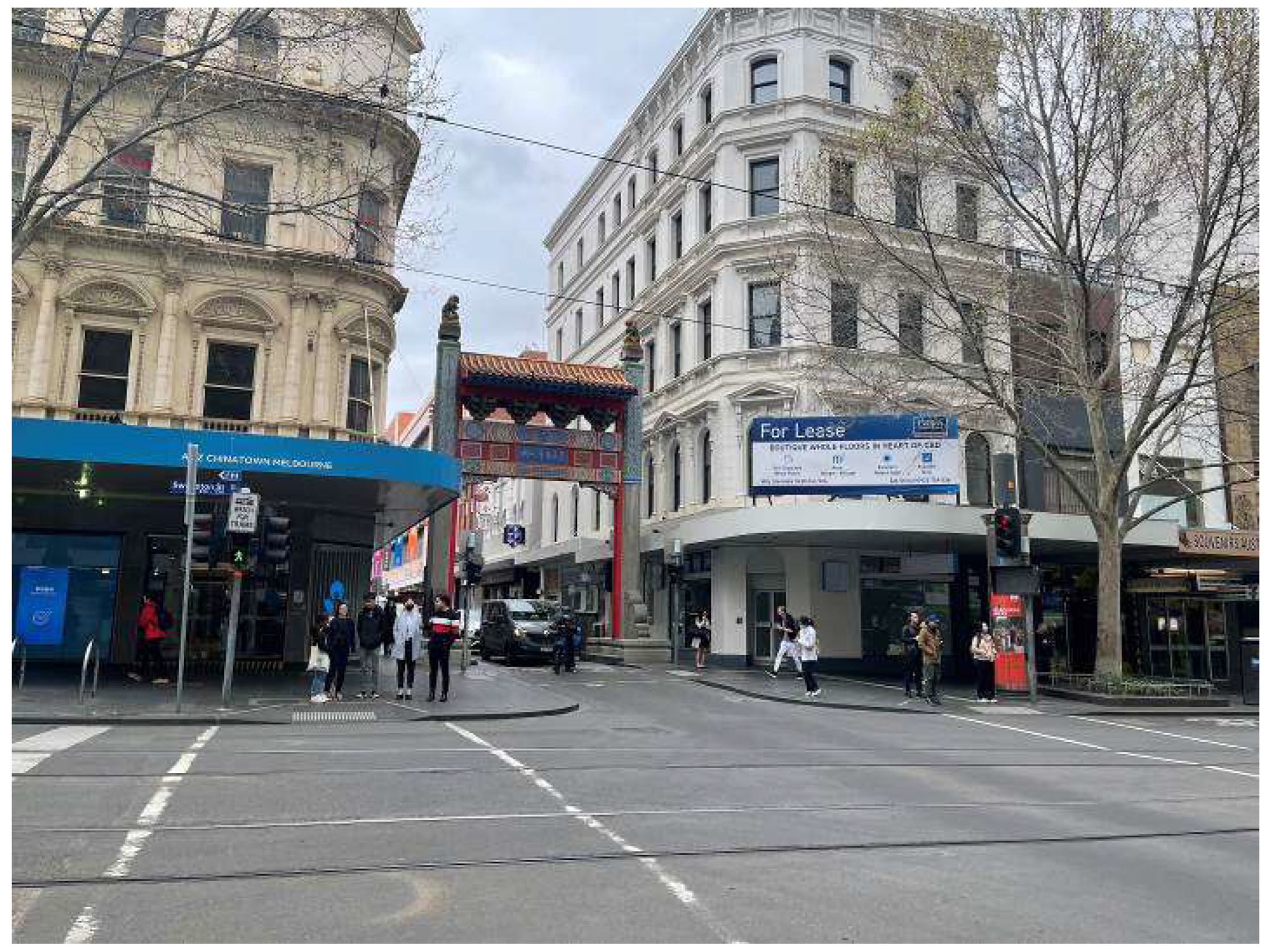
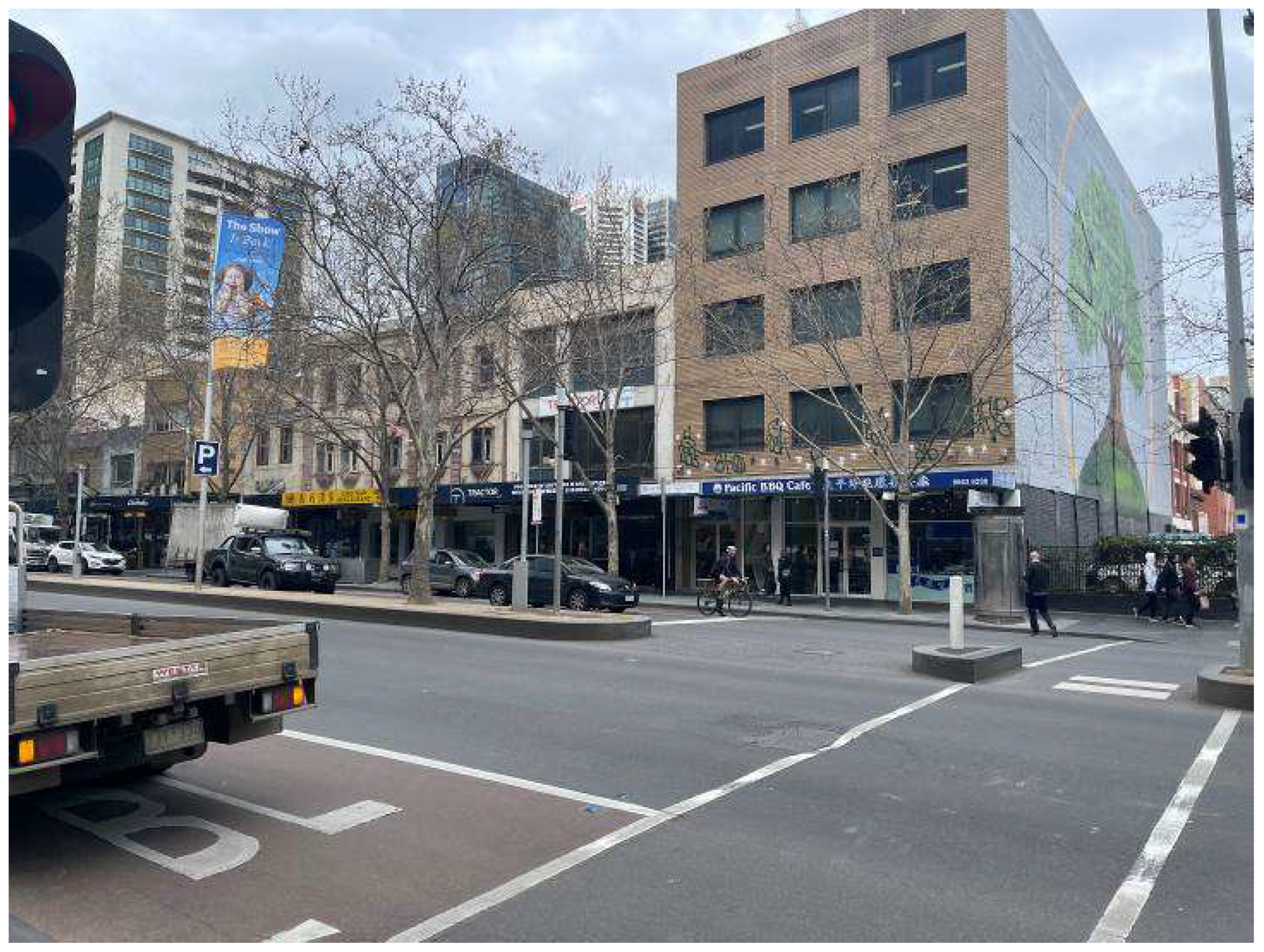
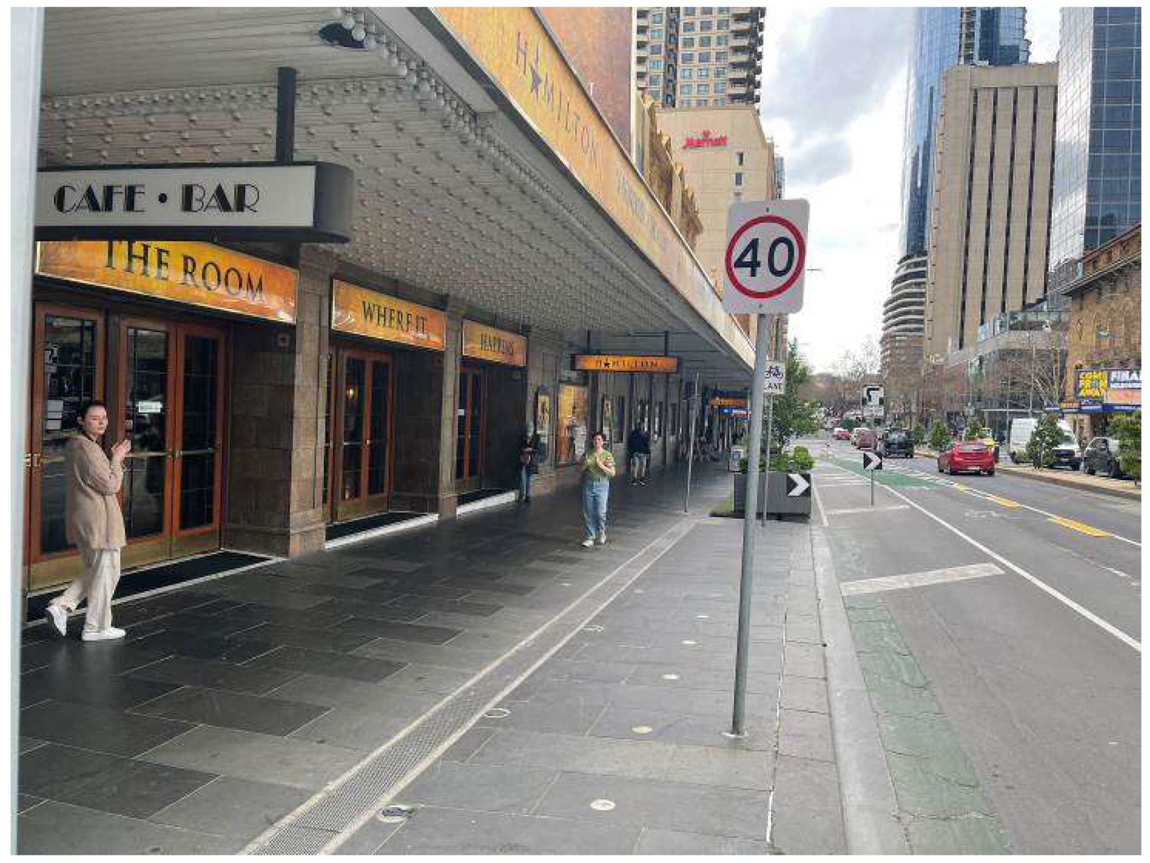
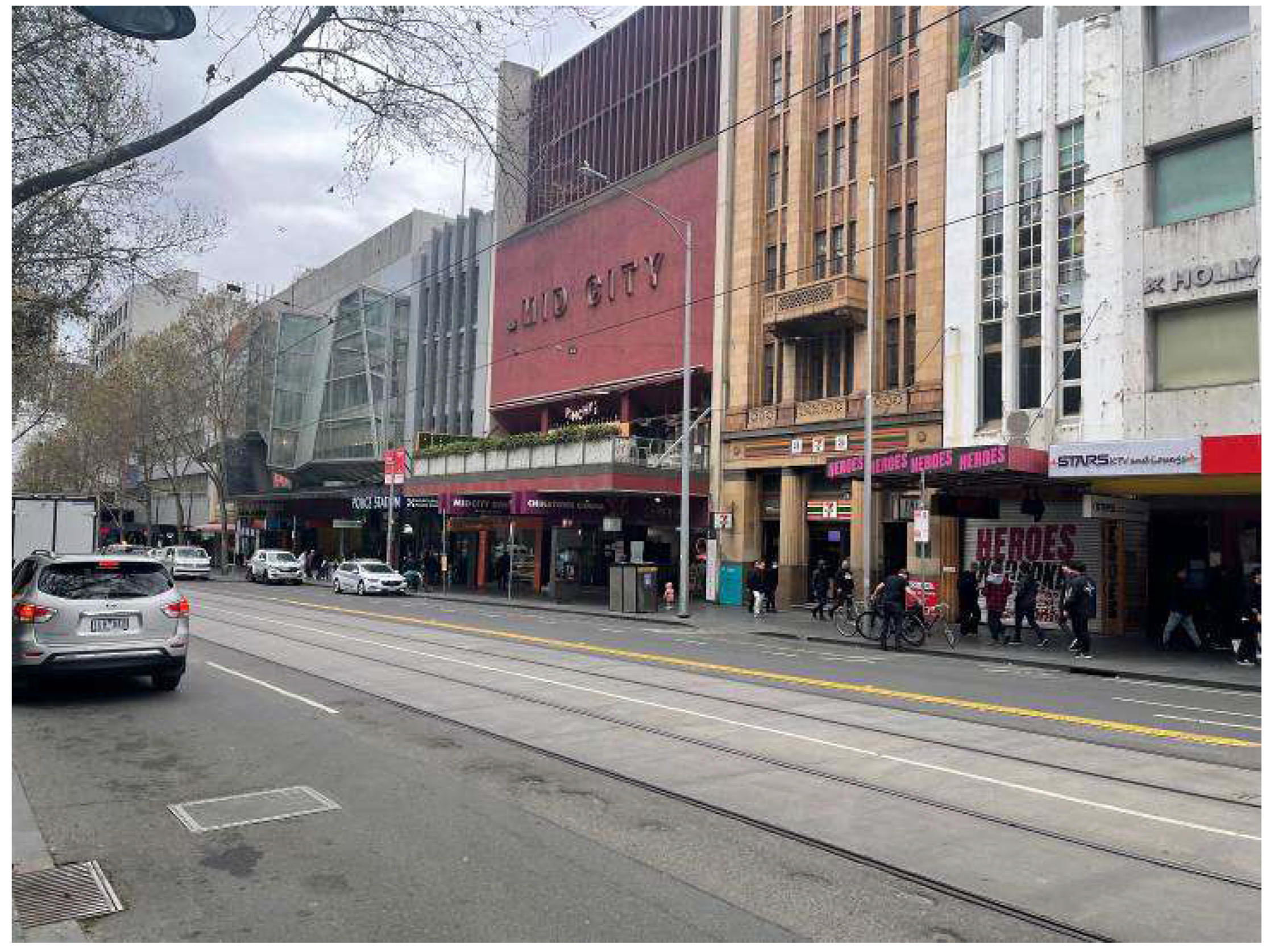
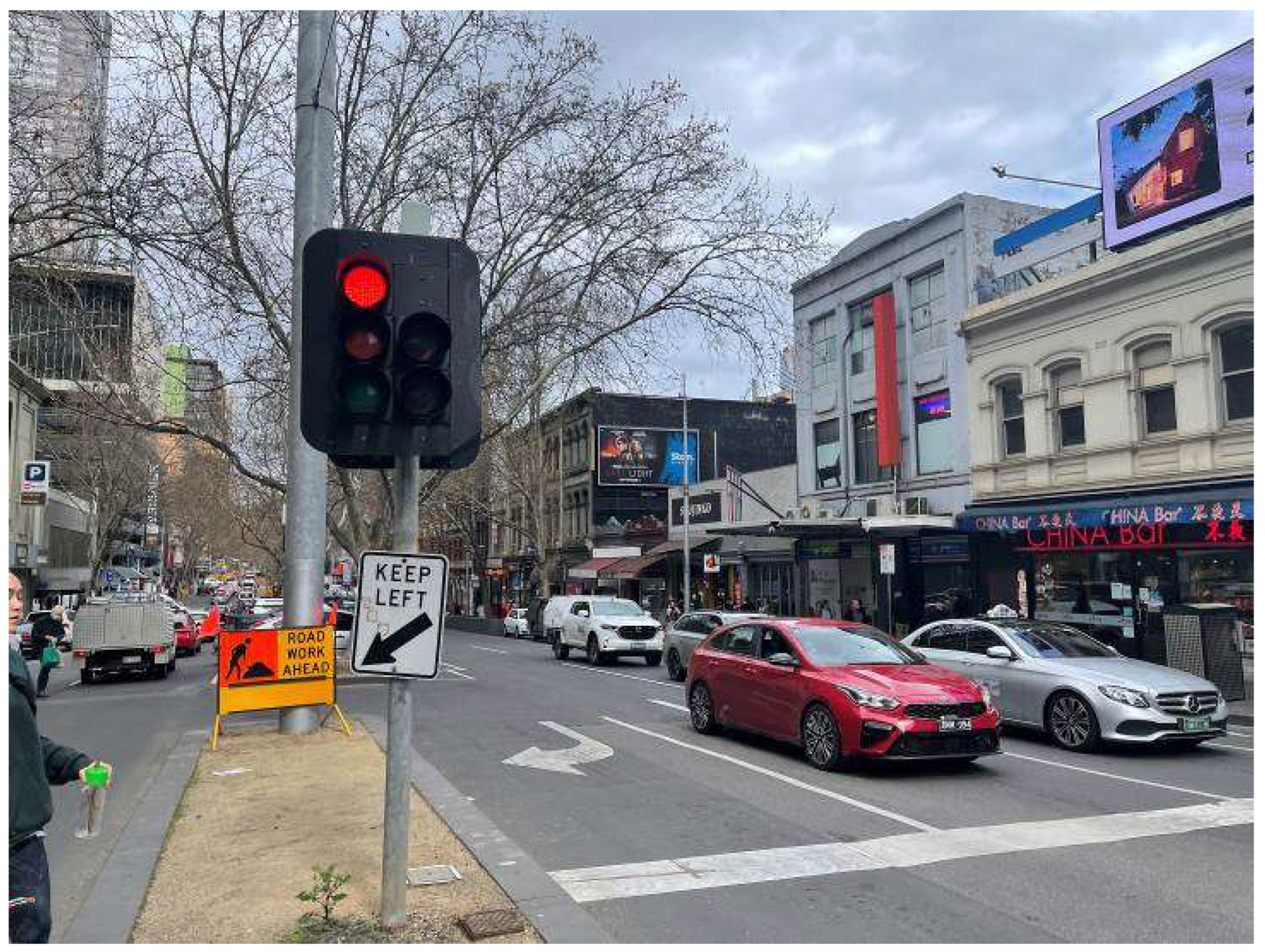
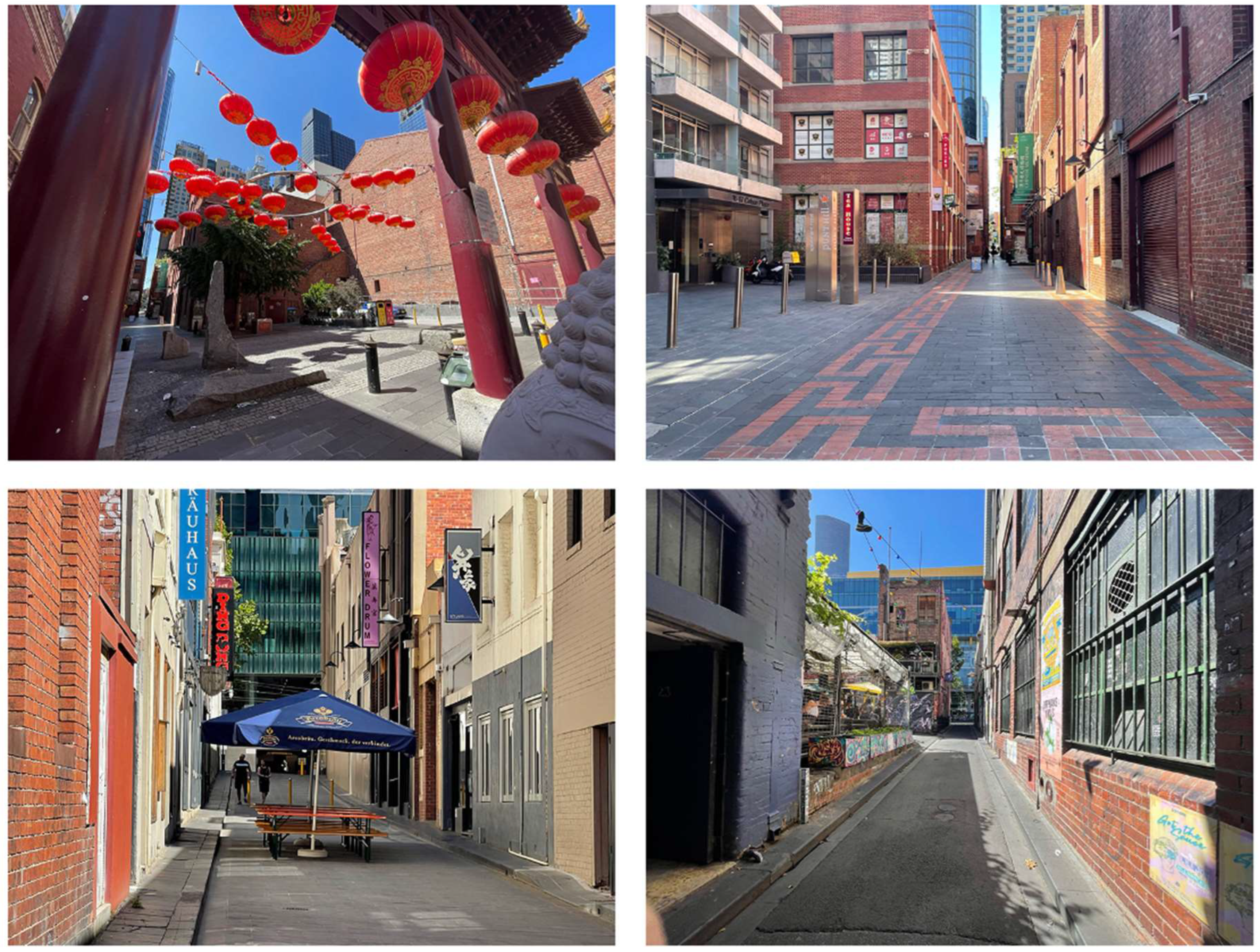
Before any planning strategies were tailored for Melbourne’s Chinatown, the Hoddle Grid was laid out as a foundation for the city’s urban planning [55,56]. As seen in Figure 1, major streets, including Swanston Street, Russel Street, Exhibition Street, Bourke Street and Lonsdale Street, are all planned to be around 30 m wide (one and a half chain). While intersecting streets that divide the blocks, such as Little Bourke Street (Figure 2), are approximately 10 m wide (half chain). These streets split the precinct into four major blocks, each around 100 m by 200 m, with Little Bourke Street as the central street [57]. On Lonsdale, Bourke, Swanston, Exhibition and Russell Streets, mixed-use dwellings often occupy large plots (Figure 3, Figure 4, Figure 5, Figure 6 and Figure 7). However, hidden dwellings in the laneways facing Little Bourke Street often have much smaller, single-use plots. Figure 1, Figure 2, Figure 3, Figure 4, Figure 5 and Figure 6 provide information on the four border streets and the precinct’s surrounding cityscape. Due to the tram access and subsequent pedestrian flow, Swanston and Bourke Streets are mostly populated with mixed-use and large retail centres (Figure 3 and Figure 6). Common functions of Melbourne’s Chinatown include restaurants, cafés and retail. On central Little Bourke Street, a Chinese restaurant is the most common function (Figure 2). As a heritage precinct, a lack of emphasis on cultural functions is identified during the field observation. Buildings under the Victorian Heritage Register (the highest protection and significance level in the State of Victoria) do not accentuate their cultural significance through their current use. Unexpectedly, only three (the Chinese Mission Church, Her Majesty’s Theatre and the Num Pon Soon Society) of the seven Victorian Heritage Register buildings within the enclave still possess cultural or religious functions (Figure 1).
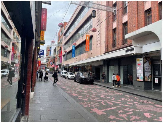
Figure 2.
Little Bourke Street is the main street of Melbourne’s Chinatown.
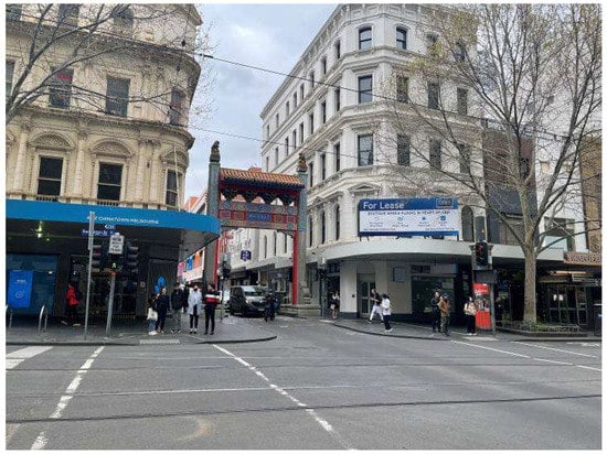
Figure 3.
Swanston Street entrance of the precinct.
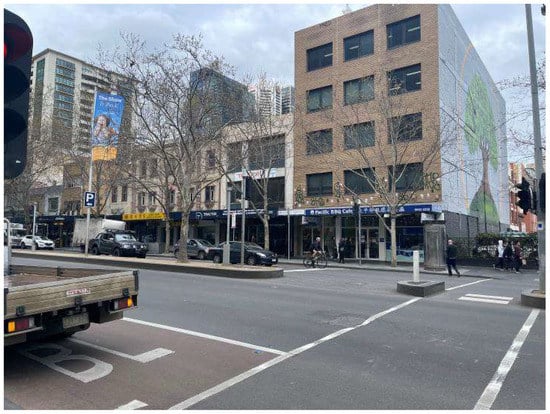
Figure 4.
Lonsdale Street side of the precinct.
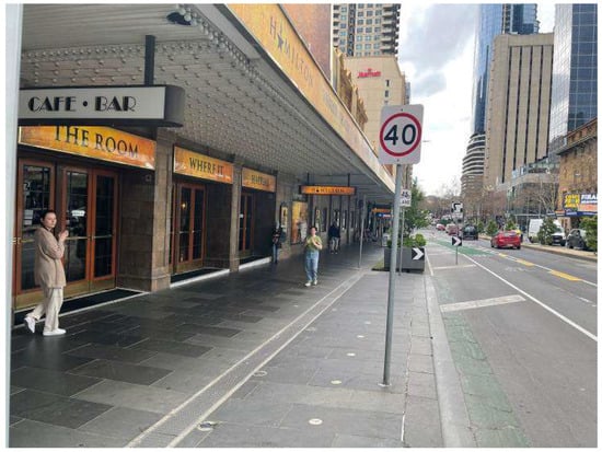
Figure 5.
Exhibition Street side of the precinct.
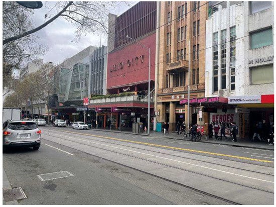
Figure 6.
Bourke Street side of the precinct.
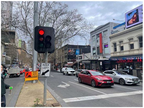
Figure 7.
Russell Street side of the precinct.
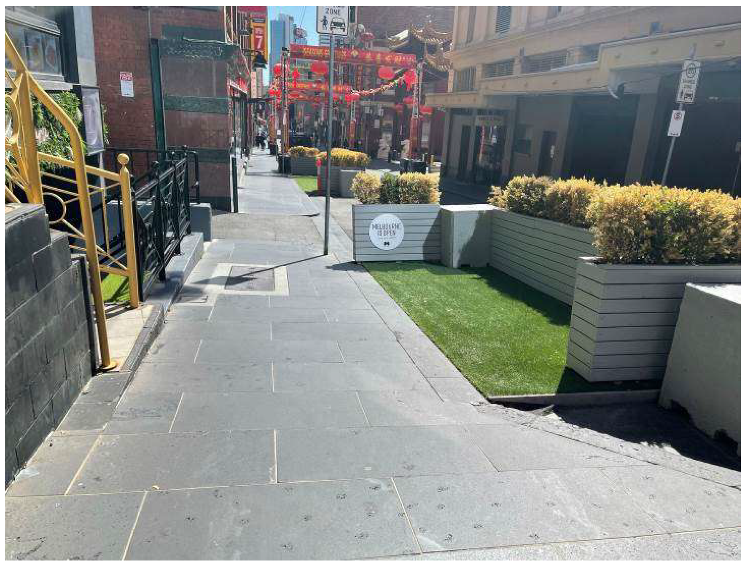
In Action Plan, the central street is not viewed as a grandeur walkway for sightseeing but a street for pedestrians and vehicles with ‘desired congestion’ as one of the street’s intrinsic characteristics. To maintain the ‘desired congestion,’ the comfort and safety of pedestrians and the needs of traffic, deliveries and shopfronts, one core principle for the treatment of the main street entails certain sidewalks being widened. As seen in Figure 8, such widening of sidewalks is reflected only during the field observation but not space syntax analysis. The results show that such widening is not continuous along the central street. Irregular patterns of the sidewalks were observed during the field observation. Such an irregular widening was mainly performed to create outdoor seating areas, shopfront entrances, loading bays and some on-street parking. During the observation, the central street was observed to be congested with all the above-mentioned usage of an already narrow street.
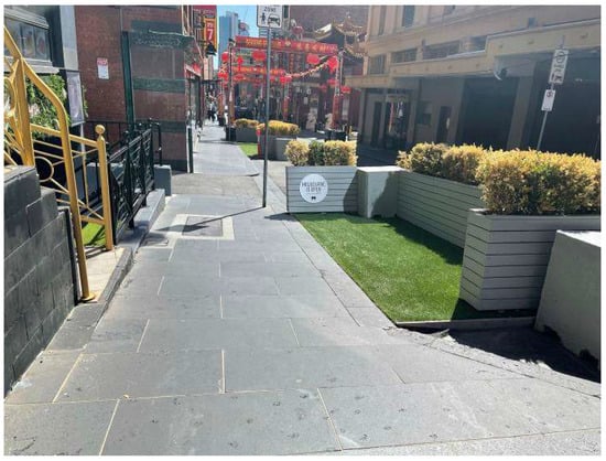
Figure 8.
Sidewalk widening.
Laneway culture is unique to the urban fabric of Melbourne, which Chinatown is an essential part of [56]. Laneways in Melbourne work as a network that navigates pedestrians and serves as a critical contributor to the city’s overall identity [58]. From the Action Plan and the field observation, a total of twenty-four laneways are identified, including twelve open-end laneways and twelve close-end laneways. Most of the twelve close-ended laneways are used for services (loading bay and back gates) in the precinct. Open-end laneways, all running in the north/south direction, are laneways that prioritise pedestrian movement and commercial activities (Figure 9). In particular, Cohen Place is now presented as a major laneway cultural hub, where the Museum of Chinese Australian History is located. A contrast was observed between the livelihood in laneways. Laneways that prioritise commercial activities and pedestrians are observed to contain a variety of functionalities, such as the museum, restaurant and bar. Among these laneways, Tattersalls Lane, Cohen Place and Market Lane were the most vibrant (Figure 9). Despite its relatively narrow width compared to other pedestrian-friendly lanes, Tattersalls Lane (Figure 9) represents a lively streetscape with restaurants, a cultural society and a popular outdoor bar [59]. Market Lane is mainly employed as an outdoor seating area for restaurants from the observation (Figure 9) while creating a visual connection between Little Bourke Street and Bourke Street. In Cohen Place, the pathway to the museum is led by the pavement design with traditional Chinese patterns and museum banners along the way (Figure 9), due to the low visibility of the museum from the central street. Contrasting to the vibrancy of those laneways that prioritise pedestrians, laneways for services in Chinatown are not favoured by the pedestrians, such as Hughs Alley, Star Alley and Bullens Lanes (Figure 10). Most of the service lanes were observed to be occupied by rubbish bins, exposed buildings services, and parking with low-level pedestrians. Despite the occasional graffiti and pavement painting, no other treatments on the ground level were observed to add vibrancy to these service lanes.

Figure 9.
Vibrant laneways: Cohen Place 1, Cohen Place 2, Market Lane and Tattersalls Lane (Left to Right).
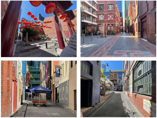
Figure 10.
Service laneways: Bullens Lane, Hughs Alley and Star Alley (Left to Right).
The Chinatown Action Plan (1985) asserts that small node-like public spaces are required to complement the desired pattern of the precinct [3]. It argues that open spaces should be kept small and compact in the existing narrow laneway network. However, limited open spaces were observed on the main streets and the laneways, despite one small square in front of the Cohen Place cultural precinct. Moreover, apart from the artificial greenery as a part of sidewalk widening on Little Bourke Street, barely any green space was observed during the field observation.
3.2. Results from Axial Analysis
3.2.1. Connectivity
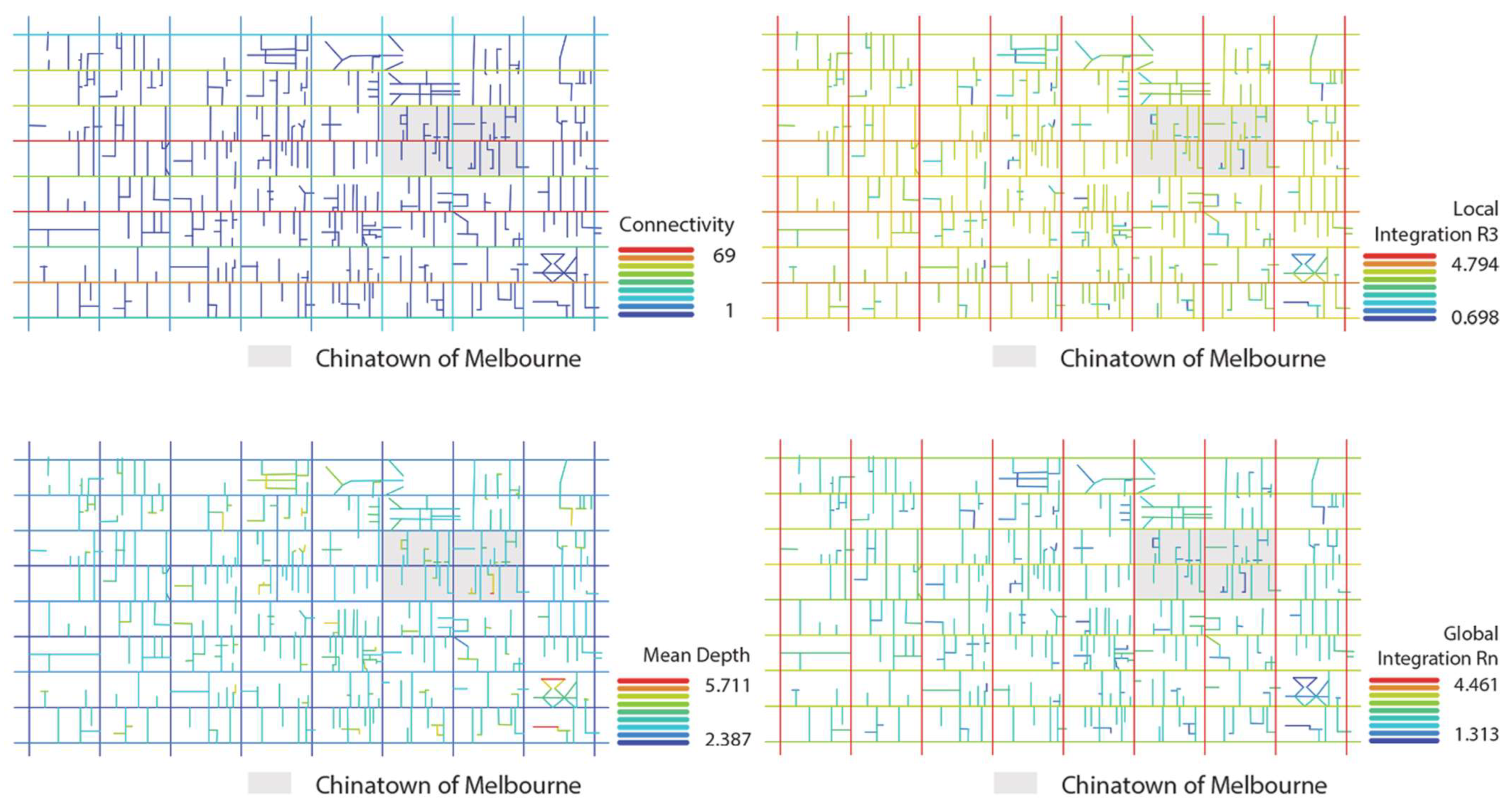
Most laneways (type a streets) possess low connectivity values, ranging from 1 to 4. Little Bourke, Lonsdale and Bourke Streets (type c streets) have the highest connectivity values (from 38 to 69), significantly higher than the average connectivity of 8.483 within the precinct. The difference in connectivity between laneways and main streets is significant, which reflects the unique spatial layout of Melbourne’s Chinatown. The main streets have a high level of connections with their side streets, making them spatially permeable. With the extreme connectivity difference between main streets and laneways, a spatial boundary is formed by the six main streets. The numerical results in Table 5 are presented as diagrams in Figure 11, where red and blue depict high and low connectivity values accordingly.

Table 5.
Results from space syntax analyses.
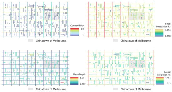
Figure 11.
Results from Section 3.2.
As Melbourne’s Chinatown is a pedestrian-friendly precinct most suitable for walking access with limited parking and car access, the local scale integration and the mean depth value at a walking scale are the focus of this analysis in determining the accessibility and depth of the area [3]. The precinct is not a ‘deep’ system since the highest (5.711) and the lowest (2.387) mean depth are both within ~50% difference from the average mean depth (3.611). The low mean depth relates to the grid system layout, where most laneways are open-ended, connecting two main streets (north to south). On the contrary, the precinct’s layout before the deduction of east to west laneways and cul-de-sacs (dead-end laneways) has a higher mean depth, making the system ‘deeper’ [3,60]. Many cul-de-sacs are connected to the main axes. They contribute to the identified variations in the connectivity values, which also have an impact on the intelligibility values.
3.2.2. Integration
As seen in Table 2, the calculation of integration value (HH) involves the reciprocal of mean depth (MD). An inverse correlation between the two sets of values can be seen in Table 4. For instance, Russell has the lowest mean depth and the highest integration; Croft Alley retains the highest mean depth and the lowest integration. Overall, street types b and c (main streets) have much higher integrations (both globally and locally) than street type a (laneways), making the main streets more accessible than the laneways. With a global integration of 4.461 and local integration of 4.794, Russell Street is the most accessible in the Chinatown precinct. Apart from Croft Alley and Stevenson Lane, most laneways have integration values less than ~50% off the average value (2.552 for global and 3.227 for local). The two laneways have turns, mostly diverging from north to south into the east to west. The turns of these laneways result in more directional changes (syntactic steps), reducing the integrations significantly.
3.2.3. Intelligibility
Intelligibility describes the correlation between connectivity and global integration. It measures if the local spatial structure can help interpret the entire spatial system (Table 2). Through intelligibility analysis, spatial identifiability can be characterised to reveal what one can comprehend from the spatial layout matches or is useful guidance for what one cannot see [44]. The authors first assumed high intelligibility in the precinct, as the Hoddle Grid layout of Melbourne should be easily identified and recognised by people [61,62]. However, the intelligibility results in Melbourne’s Chinatown contradict the assumption. In this case, an intelligibility score of 0.32 depicts that the precinct is not highly identifiable. A low intelligibility value (between 0 and 0.5) represents the low correlation between integration and connectivity, reflecting that the local spatial structure does not comprehend the entire spatial system well. R2 locates at 0.5–0.7 represents good spatial identifiability; R2 locates at 0.7–1 reflects high spatial identifiability [44,49]. Moreover, the street with the highest connectivity does not have the highest global and local integration. This shows that the precinct does not necessarily have an apparent central structure, which echoes the Hoddle Grid layout. The system involves six main streets that are all highly accessible and connected with laneways running in the south-north direction. The authors of this study argue that the low intelligibility value is mainly caused by the low connectivity values of the laneways (more than ~50% difference from the average). Findings in the field observation also provide context to this phenomenon. Laneways in the precinct connected to Little Bourke, Swanston, Russell, Exhibition and Bourke Streets do not follow any grid system or alignment. Hence, the layout of these laneways does not necessarily comply with the uniform grid system. The width and depth of each laneway are a result of a rather organic development throughout the precinct’s evolvement. From the space syntax results, these laneways are not classified as numerical outliers as there are twenty-three of them in the precinct, while only six main streets are identified. These laneways can be viewed as ‘spatial outliers’ to the well-established Hoddle Grid. Most scholars and planning policies recognise Little Bourke Street as the central passageway of the ‘valley-like’ precinct [3,10,11]. However, from the axial analysis, all six main streets have high integration and connectivity, which reflects their accessibility, convenience and public exposure [41]. These results reverberate with the unique Hoddle Grid layout, where most main streets share high spatial importance. Despite not having the highest integration and minimal depth, it is worth noting that Little Bourke Street does have a peak in the connectivity and entrance density analysis.
3.3. Results from VGA
As seen in Figure 12, results from visual integration and visual isovist area analyses depict the overall visibility relationship of the precinct [39,41]. The intersections between Russell Street and the three ‘type c’ streets demonstrate the largest isovist area and the highest visual integration, implying that the visible areas are the largest at these three intersections (indicated in warmer colour tones in Figure 12). The intersections between the other two ‘type b’ streets and the three ‘type c’ streets have slightly smaller isovist areas and lower visual integration (indicated in cooler colour tones in Figure 12). On the contrary, the laneways have small isovist areas and low visual integrations. On the main streets, visual integration values are slightly higher at the laneway intersections, as those points provide more views into the laneways. During the site observation, the views from and to these laneway intersections are also influenced by temporary dining furniture, signage and other service facilities, which are not reflected in the VGA analyses. It is worth noting that some cultural attractions are located on the laneways, including the Museum of Chinese Australian History. The low visibility of these laneways can hinder pedestrians from attending these cultural attractions if spots are not well-known. During the field observation, the authors observed that direction signage is implemented on Little Bourke Street to guide visitors to Cohen Place, where the Museum of Chinese Australian History is located.

Figure 12.
Results from VGA Analysis (Isovist area and Integration HH).
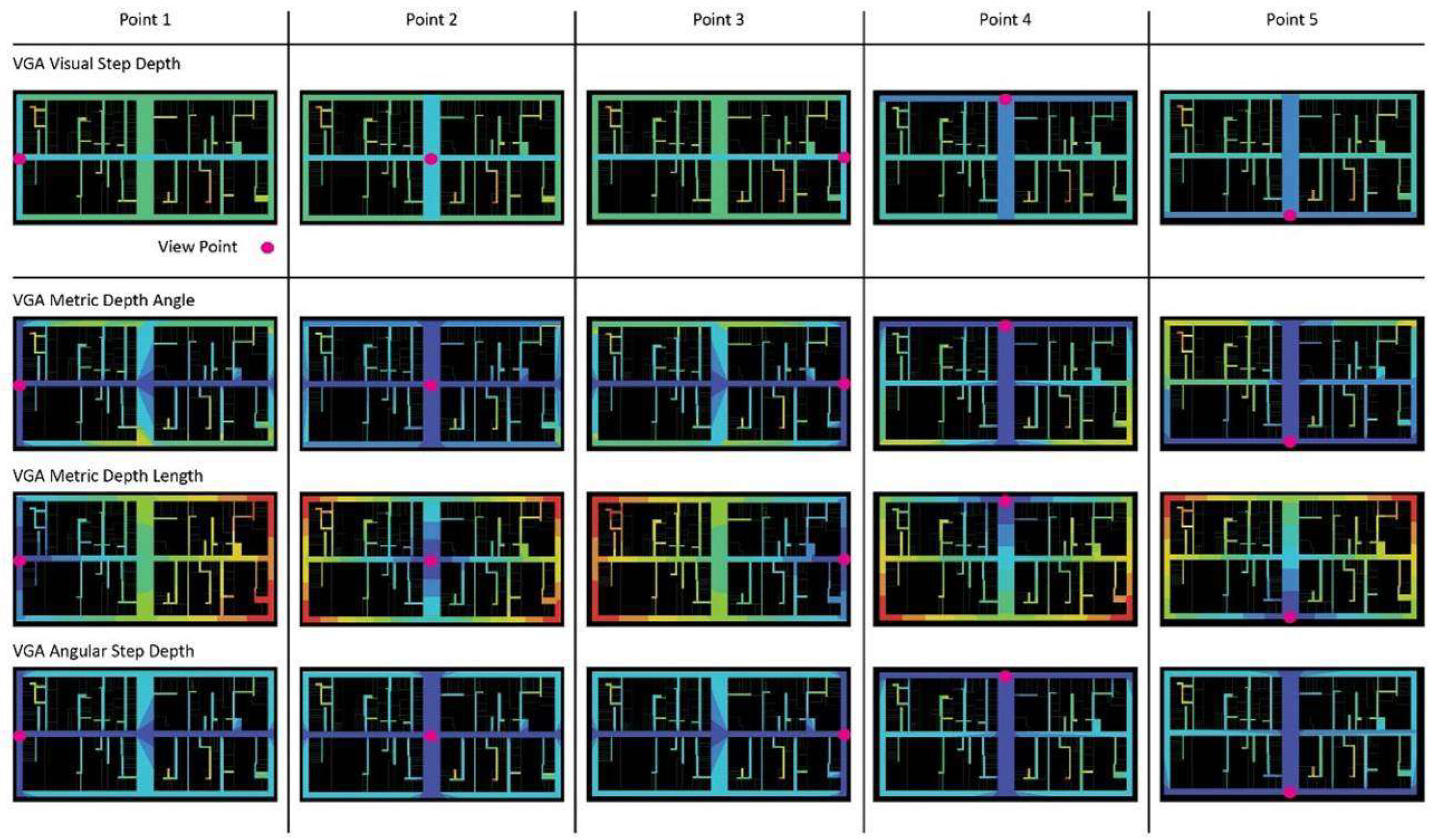
Five main entrances of Chinatown are marked as the most likely first viewpoints for the visual step depth, metric depth and angular step depth analysis. Results from this tactic mainly concern visual depth (presented in Figure 13). Overall, the results from VGA show that the laneways of Melbourne’s Chinatown have poor visual connections with all five viewpoints. Compared with the main streets (type b and c), laneways require more visual syntactic steps (visual step depth), longer distance (metric depth) and higher angular variations (angular step depth) to be visible from the five identified viewpoints. The laneways in this precinct are visually ‘deep’, affecting the vitalisation of the laneways and the dwelling within them. For instance, Cohen Place, the cultural square of Melbourne’s Chinatown, is only relatively visible from viewpoint 3.
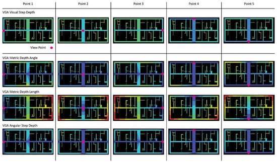
Figure 13.
Results from VGA Analysis (visual depth—five entrance viewpoints).
3.4. Results from Spatial Relationship between Buildings and Streets (Ground-Level)
3.4.1. Topological Depth
Melbourne’s Chinatown has low topological depth, and pedestrians can enter most shopfronts directly in the precinct with minimal semi-private buffer zones. Only a few outliers have a buffer zone, including one of the few residential towers in the precinct. Although the precinct is extensively protected from heritage overlay, there is no restriction on the residential use of buildings. Despite the gentrification and potentially higher revenue to operate as commercial development, this study argues that the shallow topological depth is another factor in why the precinct is mostly commercialised [63]. Researchers contend that low topological depth and transparent frontage can enhance safety, increase the natural surveillance of an area, and enable people inside and outside a building to see each other [53]. In this case, having a low-topological depth between public and private spaces can benefit commercial activities in the precinct.
Topological depth provides a good indication of the level of natural surveillance and the spatial depth from public to private of Melbourne’s Chinatown, which are vital aspects to consider when interpreting the changes in the precinct’s spatial layout, usage and identity [50]. However, other factors on various scales have contributed to Melbourne’s Chinatown’s spatial configuration and functionality; the topological depth between public and private space is not the only one. Results from the previous section indicate that the laneways have relatively high mean depth, reflecting the spaces’ privacy. However, during the precinct’s development, the number of east/west laneways has been reduced, which echoes the area’s functionality change [60]. Most laneway reduction happened before and during the Chinatown Action Plan (1985) was published to reduce unwanted cul-de-sacs in the precinct. Young’s study showcases that a close net community was formed by three families living in Cohen Place between 1880 to 1900 [64]. The Cohen Place area had many more small and narrow lanes running east to west compared to the current layout. Such laneways provided more privacy through a higher mean depth and topological depth. A courtyard-like space was formed near the current Cohen Place and is now presented as a major cultural hub, where a heritage precinct with the Museum of Chinese Australian History is located. During the field observation, the authors found that the original plots of the three families’ homes have been combined into one plot, where one of the few residential apartments in the precinct is located. The topological depth of the original layout (before the east/west laneway reduction) was much higher than the current layout (post east/west laneway reduction). However, the current apartment is gated with a high level of surveillance by security cameras, whereas the original courtyard-like layout delivers much better natural surveillance.
3.4.2. Entrance Density
The results from entrance density are first numerically documented in Table 6. According to the original theory and method, entrances with no windows next to them are not marked as entrances in the analysis [39,51]. Figure 14 depicts the existing entrances within the precinct on each street, documented in the field observation. The lengths of streets are uncovered in studies around the Hoddle Grid and maps [65]. Existing studies have provided minimal information on factors to consider when deciding the different colour gradient groups for the entrance density diagram, despite listing out mostly five benchmarks. Three benchmarks are usually provided with two other benchmarks, highlighting the maximum and minimum values. In this study, a standard statistical method—quartiles (Q1, Q2 and Q3) is incorporated to sort the different degrees of entrance density. First, all streets with zero entrance density are grouped into the ‘lowest’ group. Then, with the remaining numbers, the study identifies Quartile 1 (25%), Quartile 2 (50%), and Quartile 3 (75%) to facilitate the grouping and visualising of the data. Table 6 lists Q1 (0.4210), Q2 (0.6495) and Q3 (0.1000). Through sorting the data with clear benchmarks and data visualisation, entrance density results can be easily interpreted to provide insight into each street’s building–street relationship. As seen in the table, five groups are formed, and colours are assigned accordingly. As seen in Figure 14, Swanston, Little Bourke, and Russell Streets have the highest degree of entrance density. Lonsdale, Bourke and Exhibition Streets have a medium-high degree of entrance density. Many laneways in the precinct act as service lanes (observed during field observation) with no entrances with windows. Some laneways, including Celestial Avenue, Market Lane, Tattersalls Lane and Waratah Place, have relatively higher entrance density than the rest. During the field observation, these lanes were mainly populated with restaurants, bars and nightclubs that immerse in Melbourne’s unique laneway culture [56,66]. However, Cohen Place, the cultural centre of the precinct, exposes a lower entrance density [3,67]. Authors argue that low entrance density does not necessarily reflect its low urban liveliness but can promote flexible use of space, as there is a lower level of interference to other shop entrances. For instance, Heffernan Lane is often used as a street for night markets. The street is observed to be highly lively during the field observation. The low entrance density of Heffernan Lane makes the space highly adaptive, which subsequently activates the street as it can host different cultural events.

Table 6.
Entrance density of streets in the precinct.

Figure 14.
Entrance density diagram of the precinct.
When looking at the results from the axial analysis, entrance density and field observation together, the authors elucidate that streets with high integration and connectivity often have a high entrance density. However, Bourke Street is an exception in this instance, as few entrances have been recorded on this street. It shows the highest integration and connectivity levels but lower entrance density than the other type b and c streets. During the field observation, the authors observed large window openings on Bourke Street, since many large commercial complexes position their main entrances and displays on this street. Although the entrance density is lower than other main streets (few entrances on this street), each recorded entrance is much larger with transparent windows. Moreover, two tram stops were observed on each side of the street. The street is observed to be highly populated and possesses high urban liveliness and high natural surveillance. This links to one of the other key limitations of the entrance density analysis identified in this study: the lack of consideration of transport stations and entrance/window sizes. Moreover, shopfronts can experience a frequent change of ownership and other adaptations; methods from this tactic can only reflect the characteristics of the space during a short period. As van Nes and Yamu (2021) suggest, results from this tactic should be interpreted with results from other methods [39]. The entrance density does provide an additional level of understanding of the ground-level street network and liveliness, but the limitation of this analysis is also inevitable.
3.4.3. Constitutedness and Intervisibility
According to Hillier and Hanson (1984), constitutedness is about the degree of adjacency and permeability from buildings to public space [24]. In the original theory, buildings only constitute the street if a building can be directly accessed from the street. If buildings are located adjacent to a street, but their entrances can only be accessed indirectly (i.e., through a courtyard), the street is unconstituted. The degree of constitutedness reflects dwellings’ connection to the street and their visibility to the street. Again, scholars argue that the vitality of streets in urban areas can be epitomised through such interpretation. In Melbourne’s Chinatown, most shops open directly with no buffer zone to the streets. Even shopfronts considered ‘hidden’ mostly open directly into the laneways [56]. Most of the streets in the precinct have a constitutedness of 1 (Table 4). According to the theory of constitutedness, in streets that are constituted, the stationary activity of people is less likely to occur; more people tend to sit or stand for a prolonged period in unconstituted streets [39,40,50]. During the field observation, the width of these laneways allows very minimal space for pedestrians to sit or stand. Not many pedestrians were observed to utilise these laneways. The observation results contradict the constitutedness theory in this instance. As the width of streets is not considered in the measurement of constitutedness, the authors find the results from this tactic to be singular in the examination of Melbourne’s Chinatown.
Intervisibility is measured by calculating the ratio between entrances that face each other across the streets to entrances that do not. The way entrances and windows are positioned facing each other on the street influences the probabilities for social control and street life and control between buildings across street segments [50]. Most of the main streets in Melbourne’s Chinatown have high intervisibility. On Little Bourke Street, shopfronts with windows occupy both sides of the streets, making the street highly intervisible and lively with a high level of natural surveillance. However, when looking at the intervisibility of laneways, the singularity of results is again apparent. Four of the five shopfronts with windows on Tattersalls Lane are positioned facing each other, giving the laneway a high theoretical intervisibility. However, due to the narrowness of this laneway and the non-direct visual angle from the shopfronts, it is hard to see activities from each side of the laneway. However, for a wider laneway such as Market Lane, with all six shops facing each other, activities on each side of the laneway become more visible. Authors find the lack of consideration of the street width and the angle of views in intervisibility measurement propagate singular results when testing on laneways. When using intervisibility to reflect spatial characteristics, results must be understood and interpreted with other spatial measurements. In this study, field observation suggests different findings on how intervisible the laneways in Melbourne’s Chinatown are than the theoretical intervisibility measurements.
4. Discussion
Further to the understanding of the street layout in the results, the discussion section addresses key findings that can facilitate the preservation of Melbourne’s Chinatown and better serve the precinct as an urban heritage attraction.
4.1. Continuity of Little Bourke Street
The section of Little Bourke Street that runs from Swanston to Exhibition Street is the known main street of Melbourne’s Chinatown precinct. However, Russell Street dissects the precinct with high connectivity and integration. During the field observation, Russell Street is much wider than Little Bourke Street, which is not recognised in the space syntax axial analysis. To preserve the spatial continuity of Little Bourke Street, four traditional Chinese gateways are placed at the three intersections on this street, which can help pinpoint the key entrances of the precinct and enhance the continuity of the Chinatown fabric along Little Bourke Street [68]. Similar to existing research, the results of this study show that space syntax methods only help understand spatial characteristics of the precinct from floor plans and maps, causing unclear and singular interpretations of the precinct’s identity [69]. Therefore, field observation is an essential part of this study to validate findings from space syntax. In studies related to urban heritage sites, previous studies mostly run axial analysis (macro-scale) and VGA analysis (semi-urban scale) parallel to examine the consistency of results from space syntax analysis [36,49]. This study identifies inconsistencies and outliers in results from the four-scale analyses with joint methods. With the introduction of the micro-urban scale analysis and human-scale field observation, the study provides a more comprehensive understanding of the spatial characteristics and identity of Melbourne’s Chinatown. The methodology of this study should be tested with other urban heritage sites with different cultural backgrounds.
4.2. Laneways as Spatial Outliers in a Grid System
Many existing scholars argue that Melbourne has a unique laneway culture without clarifying the underlying spatial reasons [55,56,66]. This study offers a spatial interpretation of the uniqueness of the laneway culture through the intelligibility results. The laneways interrupt the highly identifiable Hoddle Grid system as ‘spatial outliers’ shown in the intelligibility analysis, making it harder to recognise and master by the pedestrians in wayfinding. Based on the results, this study contends that laneways make the overall Hoddle Grid system spatially more engaging and unique through their interruption of spatial regularity [70]. Unlike spaces with a maze effect, in Hoddle Grid, regardless of the location of the laneway, they are always linked to the main streets [70]. Due to the feature of the street layout, laneways in the grid system are creating a good structure system for wayfinding, despite the low intelligibility value. As seen in the field observation results, there are no drastic changes in the structural properties of the precinct and the entire city area. The intelligibility study of Chinatown provides an epitome of wayfinding in the city grid area with non-uniformed laneways. For Melbourne’s Chinatown and the entire grid system with laneways across, the low intelligibility caused by the ‘spatial outliers’ of the laneways is not viewed as a negative aspect that causes uneasy wayfinding. Kaplan (1979) suggests that a more complex urban pattern may improve the pedestrians’ experience of the space by slowing down their cognitions [49,70]. Authors of this study argue that despite causing a low intelligibility value, the laneways attaching to the Hoddle Grid system do not necessarily hinder wayfinding but potentially make navigating more engaging, which is a spatial justification of the appealing laneway culture in Melbourne. The semi-urban scale analysis of the topological relationship between private and public space also sheds light on the use of laneways. Heffernan Lane shows that laneways with low entrance density can have a high adaptability and flexibility. As a limitation, this study only involves Melbourne’s Chinatown as a case study. Further studies are recommended to examine the correlation between street width and entrance density, intervisibility and functional adaptability, employing more case studies from diverse cultural backgrounds.
4.3. Lack of Cultural Use Buildings
With most of the dwellings in the precinct functioning as restaurants or including at least one restaurant, the precinct is crowded with Chinese cuisine as well as cuisines from other cultures. However, a significant lack of cultural-use dwellings is detected. Moreover, among heritage buildings recognised with high heritage significance by the Victorian Heritage Register, only three involve cultural usage. The Open House of Melbourne initiative annually provides guided tours of some of these buildings [71]. Other cultural events such as RISING and celebrations of Chinese festivals are also introduced to the precinct [72,73]. However, the daily cultural use of dwellings in the precinct is minimal. It is worth noting that the RISING event 2022 took place at the golden square car part, which is not registered with the highest level of heritage significance [2]. Digital technologies are involved in turning the car park into an engaging art venue. The authors of this paper assert that it is worth considering the everyday cultural use of dwellings with or without heritage significance, and the involvement of digital technologies can be advocated to enhance the precinct’s cultural identity.
The high spatial depth and the low integration of Cohen Place are other potential points of improvement. On the macro, semi-urban and micro-scale analysis, Cohen Place is identified as having low connectivity, integration visibility and entrance density. These spatial characteristics of Cohen Place make the laneway and the Museum of Chinese Australian History endure low permeability, accessibility, visual connection and subsequent low liveliness. Some spatial strategies are already implemented to vitalise the laneway. During the field observation, a square with a traditional Chinese gateway is observed at the intersection of Cohen Place and Little Bourke Street. The square is the only open space on Little Bourke Street, which acts as a buffer zone for the laneway and can help draw pedestrians’ attention. Previous research suggests that this square is often utilised to host key cultural events during Chinese festivals [1,11]. However, the space is not largely occupied during the field observation and has limited seating. Signage is placed on Little Bourke Street to direct pedestrians to the Cohen Place cultural centre. On top of existing strategies, this study suggests the increase in buildings with cultural use can potentially facilitate the formation of a more engaging and connected cultural zone, as opposed to the current standalone museum in a narrow laneway.
5. Conclusions
This study incorporates a four-scale analytical framework to explore the street layout of Melbourne’s Chinatown, incorporating field observation and space syntax. On a macro-level, the difference between connectivity, mean depth and integration of main streets and laneways in the precinct is highly significant. A low intelligibility value is scrutinised, resulting in low spatial identifiability. However, the study argues that the low intelligibility is primarily due to the ‘spatial outliers’ (laneways) in the Hoddle Grid system. With most laneways connecting to the main streets, wayfinding in the precinct is hardly hindered by the low spatial identifiability. The ‘interruptive’ effect of these laneways in the Hoddle Grid system can be viewed as a spatial interpretation of Melbourne’s unique laneway culture, potentially appealing and fun for visitors [44,56,70]. On a semi-urban level, most laneways in the precinct are visually ‘deep and hidden’ with low visual integration and isovist area. In particular, the cultural centre-Cohen Place in the precinct is visually ‘deep’ from most entrances, discouraging the encountering of visitors unaware of the location of the Museum of Chinese Australian History. However, some strategies have been implemented to overcome such spatial limitations. Chinese-style gateways act as signifiers of entrances in the precinct, one located outside Cohen Place. However, with the limited number of cultural dwellings in the precinct, the influence of Cohen Place is still limited. From a micro-urban perspective, Melbourne’s Chinatown has a low-topological depth between private and public space on the ground level, benefiting commercial activities. Based on the entrance density, intervisibility and constitutedness analyses, the urban liveliness is the highest on Swanston, Little Bourke and Russell Streets. For most laneways with narrow widths, the findings from field observation contradict the findings from the micro-urban analysis. One laneway with low intervisibility, constitutedness and entrance density was highly adaptable and flexible. As an urban precinct with high heritage values, a lack of cultural use in dwellings is observed, while ‘restaurant’ is the most predominant function in the precinct.
Three recommendations for future studies are drawn:
- Further studies are recommended to test the joint method with other case studies within grid systems. This study finds laneways can act as spatial outliers in a grid system. A joint approach can diversify and further interpret the results.
- Limitations of the micro-urban analysis, such as the impact of width of the street, window size and public transport stop, are identified in this study. Further studies are encouraged to validate the methods with urban precincts inheriting different cultural influences.
- Inconsistencies are concluded from the field observation and space syntax results. Further studies are encouraged to incorporate human-scale analysis such as field observation or interviews to comprehend space syntax results.
- As spatial-themed research of the case study remains marginalised, the study encourages future research to examine other urban characteristics of the precinct, such as architectural typology, building characteristics, public spaces, urban policies, mobility and perception of citizens.
Overall, by fathoming the precinct through joint methods, the study insightfully envisages the street layout of this precinct with evidenced-based approaches. Based on the results, suggestions are provided to better serve the precinct as an urban heritage attraction in the existing grid system, preserve its heritage identity and ultimately enhance cultural sustainability.
Author Contributions
Conceptualization, S.G.; Data curation, S.G.; Methodology, S.G.; Software, S.G.; Supervision, H.-W.C., E.J. and Z.V.; Validation, H.-W.C. and E.J.; Visualization, S.G.; Writing—original draft, S.G.; Writing—review & editing, S.G., H.-W.C., E.J. and Z.V. All authors have read and agreed to the published version of the manuscript.
Funding
This research received no external funding.
Institutional Review Board Statement
Not applicable.
Informed Consent Statement
Not applicable.
Conflicts of Interest
The authors declare no conflict of interest.
References
- Chau, H.; Dupre, K.; Xu, B. Dynamics of Chinatowns Evolution in Australia. In Proceedings of the 22nd ISUF International Conference, Rome, Italy, 22–26 September 2015; pp. 955–966. [Google Scholar]
- Vctorian Heritage Database. Available online: https://www.heritage.vic.gov.au/heritage-listings/is-my-place-heritage-listed (accessed on 6 June 2022).
- Chinatown Action Plan; Melbourne City Council-Victorian Tourism Commission: Melbourne, VIC, Australia, 1985.
- Annear, R. Nothing But Gold: The Diggers of 1852; Text Publishing: Melbourne, VIC, Australia, 1999. [Google Scholar]
- Cannon, M. Melbourne After the Gold Rush; Loch Haven Books: Mill Hall, PA, USA, 1993. [Google Scholar]
- Fitzgerald, J.; Couchman, S.; Macgregor, P. After the Rush: Regulation, Participation and Chinese Communities in Australia, 1860–1940; Otherland Literary Journal; no. 9; Otherland Literary Journal: Kingsbury, VIC, Australia, 2004; ISBN 9780646443522. [Google Scholar]
- Huck, A. The Chinese in Australia; Longmans: Melbourne, VIC, Australia, 1967. [Google Scholar]
- Markus, A. Divided We Fall: The Chinese and the Melbourne Furniture Trade Union, 1870–1900. Labour Hist. 1974, 26, 1. [Google Scholar] [CrossRef]
- Rasmussen, A. Networks and Negotiations: Bendigo’s Chinese and the Easter Fair. J. Aust. Colonial Hist. 2004, 6, 79. [Google Scholar]
- Anderson, K. ‘Chinatown Re-oriented’: A Critical Analysis of Recent Redevelopment Schemes in a Melbourne and Sydney Enclave. Aust. Geogr. Stud. 1990, 28, 137–154. [Google Scholar] [CrossRef]
- Chau, H.; Dupre, K.; Xu, B. Melbourne Chinatown as an Iconic Enclave. In Proceedings of the 13th Australasian Urban History Planning History Conference, Surfers Paradise, QLD, Australia, 31 January–3 February 2016; pp. 39–51. [Google Scholar]
- Chang, A. Can an australian chinese temple represent “australian-ness”? An Analysis of the Yiu Ming Temple, Alexandria. Arch. Theory Rev. 1999, 4, 74–80. [Google Scholar] [CrossRef]
- Couchman, S. Melbourne’s See Yup Kuan Ti Temple: A Historical Overview. Chin. South. Diaspora Stud. 2019, 8, 50–81. [Google Scholar]
- Tewari, S.; Beynon, D. Changing Neighbourhood Character in Melbourne: Point Cook a Case Study. J. Urban Des. 2018, 23, 456–464. [Google Scholar] [CrossRef]
- Wilton, J. “The Most Beautiful Joss House”: Chinese Temples in Emmaville and Tingha. Chin. South. Diaspora Stud. 2019, 8, 26–49. [Google Scholar]
- Chau, H. Migrancy and Architectural Hybridity: The Num Pon Soon Society Building in Melbourne Chinatown, the See Yup Temple in South Melbourne and the Kaiping Diaolou in China as Case Studies. In Proceedings of the Society of Architectural Historians, Australia and New Zealand: 33, Melbourne, Australia, 6–9 July 2016; Brennan, A., Goad, P., Eds.; 2016; pp. 110–120. [Google Scholar]
- Choi, C.Y. Chinese Migration and Settlement in Australia with Special Reference to the Chinese in Melbourne; The Australian National University: Canberra, Australia, 1971. [Google Scholar]
- Byrne, D. Dream Houses in China: Migrant-Built Houses in Zhongshan County (1890s–1940s) as Transnationally “Distributed” Entities. Fabrications 2020, 30, 176–201. [Google Scholar] [CrossRef]
- Beynon, D. Beyond Big Gold Mountain: Chinese-Australian Settlement and Industry as Integral to Colonial Australia. Fabrications 2019, 29, 184–206. [Google Scholar] [CrossRef]
- Birkeland, I.; Birkeland, I. Cultural Sustainability: Industrialism, Placelessness and the Re-Animation of Place Cultural Sustainability: Industrialism, Placelessness and the Re-Animation of Place. Ethic-Place Environ. 2008, 11, 283–297. [Google Scholar] [CrossRef]
- Soini, K.; Birkeland, I. Geoforum Exploring the Scientific Discourse on Cultural Sustainability. Geoforum 2014, 51, 213–223. [Google Scholar] [CrossRef]
- Eldiasty, A.; Sabry Hegazi, Y.; El-Khouly, T. Using Space Syntax and TOPSIS to Evaluate the Conservation of Urban Heritage Sites for Possible UNESCO Listing the Case Study of the Historic Centre of Rosetta, Egypt. Ain Shams Eng. J. 2021, 12, 4233–4245. [Google Scholar] [CrossRef]
- Geng, S.; Chau, H.-W.; Yan, S.; Zhang, W.; Zhang, C. Comparative Analysis of Hospital Environments in Australia and China Using the Space Syntax Approach. Int. J. Build. Pathol. Adapt. 2020, 39, 525–546. [Google Scholar] [CrossRef]
- Hillier, B.; Hanson, J. The Social Logic of Space; Cambridge University Press: Cambridge, UK, 1984; ISBN 0521367840. [Google Scholar]
- Ferguson, T.J. Historic Zuni Architecture and Society; University of Arizona Press: Tucson, AZ, USA, 1996; ISBN 0816516081. [Google Scholar]
- Letesson, Q. Minoan Halls: A Syntactical Genealogy. Am. J. Archaeol. 2013, 117, 303–351. [Google Scholar] [CrossRef]
- Kubat, A.S.; Rab, S.; Güney, Y.İ.; Özer, Ö.; Kaya, S. Application of Space Syntax in Developing. A Regeneration Framework for Sharjah’ s Heritage Area. In Proceedings of the 8th International Space Syntax Symposium, Santiago De Chile, Chile, 3–6 January 2012; pp. 1–17. [Google Scholar]
- Clark, D.C.L. Viewing the Liturgy: A Space Syntax Study of Changing Visibility and Accessibility in the Development of the Byzantine Church in Jordan. World Archaeol. 2007, 39, 84–104. [Google Scholar] [CrossRef]
- Davis, H.; Dino, B. Industrial Morphologies: The Historic London Furniture Industry and the New City of Production. In Proceedings of the 22nd ISUF International Conference, Rome, Italy, 22–26 September 2015. [Google Scholar]
- Smith, M.E. Empirical Urban Theory for Archaeologists. J. Archaeol. Method Theory 2011, 18, 167–192. [Google Scholar] [CrossRef]
- Stöger, H. Open Syntaxes View on Ancient City Quarters and Their Social Life. J. Space Syntax. 2015, 6, 61–80. [Google Scholar]
- Conroy-Dalton, R.; Bafna, S. The Syntactical Image of the City: A Reciprocal Definition of Spatial Elements and Spatial Syntaxes. In Proceedings of the 4th International Space Syntax Symposium; University College London: London, UK, 2003. [Google Scholar]
- Hillier, B. The Architecture of the Urban Object. Ekistics 1989, 56, 5–21. [Google Scholar]
- Koseoglu, E.; Onder, D.E. Defining Salient Elements of Environment and Memory: Subjective and Objective Landmarks in Ayvalik, Turkey. In Proceedings of the 7th International Space Syntax Symposium, Stockholm, Sweden, 8–11 June 2009; Volume 059, p. 11. [Google Scholar]
- Psarra, S. The Role of Spatial Networks in the Historic Urban Landscape: Learning from Venice in the Fifteenth and Sixteenth Centuries. Hist. Environ. Policy Pract. 2018, 9, 249–273. [Google Scholar] [CrossRef]
- Chiang, Y.C.; Deng, Y. City Gate as Key towards Sustainable Urban Redevelopment: A Case Study of Ancient Gungnae City within the Modern City of Ji’an. Habitat Int. 2017, 67, 1–12. [Google Scholar] [CrossRef]
- Karimi, K. Space Syntax: Consolidation and Transformation of an Urban Research Field. J. Urban Des. 2018, 23, 1–4. [Google Scholar] [CrossRef]
- Palaiologou, G.; Griffiths, S. The Uses of Space Syntax Historical Research for Policy Development in Heritage Urbanism; Springer International Publishing: New York City, NY, USA, 2019; ISBN 9783030106126. [Google Scholar]
- van Nes, A.; Yamu, C. Introduction to Space Syntax in Urban Studies; Springer: New York City, NY, USA, 2021; ISBN 9783030591397. [Google Scholar]
- van Nes, A.; Lopez, M. Macro and Micro Scale Spatial Variables and the Distribution of Residential Burglaries and Theft from Cars an Investigation of Space and Crime in the Dutch Cities of Alkmaar and Gouda. J. Space Syntax. 2010, 1, 254–257. [Google Scholar]
- Yamu, C.; van Nes, A.; Garau, C. Bill Hillier’s Legacy: Space Syntax—A Synopsis of Basic Concepts, Measures, and Empirical Application. Sustainability 2021, 13, 3394. [Google Scholar] [CrossRef]
- Montello, D. The Contribution of Space Syntax to a Comprehensive-Theory of Environmental Psychology. In Proceedings of the 6th International Space Syntax Symposium, Istanbul, Turkey, 12–15 June 2007. [Google Scholar]
- Gifford, R. Research Methods for Environmental Psychology; Wiley Blackwell: Hoboken, NJ, USA, 2015; ISBN 9781119162124. [Google Scholar]
- Xu, Y.; Rollo, J.; Esteban, Y. Evaluating Experiential Qualities of Historical Streets in Nanxun Canal Town through a Space Syntax Approach. Buildings 2021, 11, 544. [Google Scholar] [CrossRef]
- Li, D.; Yan, X.; Yu, Y. The Analysis of Pingyao Ancient Town Street Spaces and View Spots Reachability by Space Syntax. J. Data Anal. Inf. Process. 2016, 4, 177–186. [Google Scholar] [CrossRef]
- Al Sayed, K.; Hillier, B.; Turner, A.; Penn, A. Space Syntax Methodology; Bartlett School of Architecture, UCL: London, UK, 2013; ISBN 9772081415. [Google Scholar]
- Turner, A.; Doxa, M.; O’Sullivan, D.; Penn, A. From Isovists to Visibility Graphs: A Methodology for the Analysis of Architectural Space. Environ. Plan. B Plan. Des. 2001, 28, 103–121. [Google Scholar] [CrossRef]
- Lee, J.H.; Ostwald, M.J.; Lee, H. Measuring the Spatial and Social Characteristics of the Architectural Plans of Aged Care Facilities. Front. Arch. Res. 2017, 6, 431–441. [Google Scholar] [CrossRef]
- Xu, Y.; Rollo, J.; Jones, D.S.; Esteban, Y.; Tong, H.; Mu, Q. Towards Sustainable Heritage Tourism: A Space Syntax-Based Analysis Method to Improve Tourists’ Spatial Cognition in Chinese Historic Districts. Buildings 2020, 10, 29. [Google Scholar] [CrossRef]
- Van-Nes, A.; López, M.J.J. Micro Scale Spatial Relationships in Urban Studies. In Proceedings of the 6th Space Syntax Symposium (6SSS), Istanbul, Turkiye, 12–15 June 2007. [Google Scholar]
- Jacob, J. The Death and Life of Great American Cities; Random House: New York, NY, USA, 1961. [Google Scholar]
- Gehl, J. Life Between Buildings Using Public Space; Van Nostrand Reinhold Company: New York, NY, USA, 1987. [Google Scholar]
- Rønneberg Nordhov, N.A.; van Nes, A. The role of building entrances towards streets and the perception of safety in six neighbourhoods in bergen. In Proceedings of the Proceedings of the 12th Space Syntax Symposium, Beijing, China, 8–13 July 2019. [Google Scholar]
- Shu, C.-F. Housing Layout and Crime Vulnerability. Urban Des. Int. 2000, 5, 177–188. [Google Scholar] [CrossRef]
- Freeman, K.; Pukk, U. Laneways of Melbourne; Portraits of Victoria; Melbourne Books: Melbourne, VIC, Australia, 2013; ISBN 9781922129116. [Google Scholar]
- Mundell, M. From Hotbeds of Depravity to Hidden Treasures: The Narrative Evolution of Melbourne’ s Laneways. TEXT 2019, 23, 1–16. [Google Scholar] [CrossRef]
- Freestone, R. Urban Nation: Australia’s Planning Heritage; Csiro Publishing: Clayton, VIC, Australia, 2010; ISBN 9780643101906. [Google Scholar]
- Bate, W. Essential but Unplanned: The Story of Melbourne’s Lanes; State Library of Victoria in Conjunction with the City of Melbourne: Melbourne, VIC, Australia, 1994; ISBN 9780730635987. [Google Scholar]
- Yeen, C.C. Blooding a Lion in Little Bourke Street: The Creation, Negotiation and Maintenance of Chinese Ethnic Identity in Melbourne; The University of Adelaide: Adelaide, SA, Australia, 1986. [Google Scholar]
- Moreau, M. A Methodology for Exploring Relationships Among Physical Features of Residential Back-Laneways and Their Uses. In Proceedings of the State of Australian Cities Conference, Gold Coast, QUE, Australia, 9–11 December 2015. [Google Scholar]
- Poulton, F. Little Latrobe Street and the Historical Significance of Melbourne’ s Laneways. J. Public Rec. Off. Victoria 2011, 10, 95–104. [Google Scholar]
- Sima, Y. The Historical Transformation of Melbourne’s City Centre. In Proceedings of the 5th State of Australian Cities National Conference, Melbourne, VIC, Australia, 29 November–2 December 2011. [Google Scholar]
- Luckins, T. Gentrification and Cosmopolitan Leisure in Inner-Urban Melbourne, Australia, 1960s–1970s. Urban Policy Res. 2009, 27, 265–275. [Google Scholar] [CrossRef]
- Young, T.L. Community Not “Slum” in the Cohen Place Neighborhood; University of Melbourne: Melbourne, VIC, Australia, 2000. [Google Scholar]
- Hil, G.; Lawrence, S.; Smith, D. Remade Ground: Modelling Historical Elevation Change across Melbourne’s Hoddle Grid. Aust. Archaeol. 2021, 87, 21–35. [Google Scholar] [CrossRef]
- Dovey, K.; Wollan, S.; Woodcock, I. Placing Graffiti: Creating and Contesting Character in Inner-City Melbourne. J. Urban Des. 2012, 17, 21–41. [Google Scholar] [CrossRef]
- Vicscreen-Cohen Place. Available online: https://vicscreen.vic.gov.au/choose-victoria/locations/cohen-place (accessed on 6 June 2022).
- Guo, Q.; Wang, H.C.; Xu, J. Modification Peoposal-Gateways of Melbourne’s Chinatown; University of Melbourne: Melbourne, VIC, Australia, 2008. [Google Scholar]
- Pafka, E.; Dovey, K.; Aschwanden, G.D.P.A. Limits of Space Syntax for Urban Design: Axiality, Scale and Sinuosity. Environ. Plan. B Urban Anal. City Sci. 2020, 47, 508–522. [Google Scholar] [CrossRef]
- Kaplan, S. Perception and Landscape: Conceptions and Misconceptions. In Proceedings of the Conference on Applied Techniques for Analysis and Manage- ment of the Visual Resource, Village, NV, USA, 23–25 April 1979; pp. 23–25. [Google Scholar]
- Open House Melbourne Program. Available online: https://openhousemelbourne.org/ (accessed on 6 June 2022).
- RISING Festival Program List. Available online: https://rising.melbourne/festival-program (accessed on 6 June 2022).
- Chinatown Precinct Association-Chinatown Melbourne. Available online: https://chinatownmelbourne.com.au/ (accessed on 6 June 2022).
Publisher’s Note: MDPI stays neutral with regard to jurisdictional claims in published maps and institutional affiliations. |
© 2022 by the authors. Licensee MDPI, Basel, Switzerland. This article is an open access article distributed under the terms and conditions of the Creative Commons Attribution (CC BY) license (https://creativecommons.org/licenses/by/4.0/).

