Abstract
In recent years, Spain, in an effort to meet European Union (E.U.) targets, has been developing different strategies to promote the installation of renewable energy plants. In this regard, evaluating territories to assess their potential and thus identify optimum sites for the installation of energy-generating facilities is a crucial task. This paper presents a comprehensive geographic information system (GIS)-based site-selection methodology for wind-power plants in the province of Córdoba, which has hitherto been regarded as unsuitable for this sort of facility owing to the lack of wind resources. Three scenarios have been set out, each of which presents a different set of restrictions. Scenario 2 applies the most stringent restrictions in the specialized literature, and finds no suitable areas for the installation of wind-energy plants. However, Scenario 1, which applies the least stringent restrictions, and Scenario 3, which applies the same restrictions currently in force for other wind turbines already in operation in Andalusia, have led to the identification of several areas that could a priori be considered suitable and now need more detailed analysis. The results illustrate the convenience of undertaking multiscenario analyses.
1. Introduction
Renewable energy is one of the greatest hopes of guaranteeing the supply of energy in all territories; it reduces energy dependence and is less harmful for the environment than other energy sources. It is therefore unsurprising that the European Union is actively trying to promote the generation and use of renewables: they help reduce the emission of greenhouse gases while promoting energy saving and efficiency [1,2,3,4].
Given the important role that renewable-energy sources play in this context, identifying suitable sites for the installation of renewable-energy facilities is an important task. Various authors have developed location models based chiefly on territorial analysis. In these analyses, the availability of the resource (wind, sunlight, etc.) is assessed in combination with a set of criteria, the aim of which is largely to preserve the interests of the local population and their livelihoods (distance to inhabited nuclei, distance to transportation infrastructure, etc.), to protect heritage items (distance to protected natural areas, historical and archaeological areas, etc.), and to ensure energy efficiency (distance to the electric grid, forested areas, orography, etc.). In general, these studies use geographic information systems (GIS) in combination with multicriteria evaluation techniques to determine the suitability of different areas. Examples include Voivontas [5], Domínguez and Amador [6], Angelis-Dimakis et al. [7], Mourmouris and Potolias [8], and Resch et al. [9].
The widely cited work by Baban and Parry [10], which deals with the generation of wind energy in the United Kingdom, was one of the first attempts to identify the most suitable areas for the installation of wind turbines. In this case, the criteria and the weights assigned to them were based on questionnaires and interviews. Hansen [11] followed a similar methodology in Denmark, using interviews with specialists in spatial planning. For their part, Yue and Wang [12] generated two different scenarios (prioritized by renewable energy or by wildlife) to identify the best locations for wind turbines in Chigu (Taiwan), while Tegou et al. [13], Al-Yahyai et al. [14], Effat [15], and Al-Shabeeb et al. [16], working in Greece, Oman, the Red Sea Governorate (Egypt), and the northwest of Jordan, respectively, used Saaty’s hierarchical analysis method (AHP) [17,18] to assign weights to their selected criteria. This method is commonly used in location studies because it does not require complex mathematical calculations and guarantees consistency of the weights.
Other important studies include, for the United States: Rodman and Meentemeyer [19] in California, Miller and Li [20] in Nebraska, Van Haaren and Fthenakis [21] in New York, and Gorsevski et al. [22] in Ohio; and for Europe: Szurek et al. [23] in Poland, and Panagiotidou et al. [24] and Latinopoulus and Kechagia [25] in Greece. All of these works use AHP for the weighting of the criteria.
Höfer et al. [26] and Sunak et al. [27] also applied this methodology in Germany and reviewed previous projects aimed at locating optimum sites for wind farming through the combination of the GIS and multicriteria evaluation methods, leading to interesting methodological conclusions linked to a lack of explanation concerning criteria, restrictions, and weights, and the subjective assignation of weights.
Various studies have focused on the Spanish case. Ramírez Rosado [28] analyzed the wind-power potential of La Rioja (northern Spain), while Schallenberg-Rodríguez and Notario-del Pino’s [29] work in the Canary Islands, which could become a standard reference for future studies on other Spanish islands, must also be highlighted. In the south, Sanchez Lozano et al. [30] analyzed the region of Murcia, while Díaz-Cuevas et al. [31] analyzed the potential of the province of Cádiz for two scenarios with different restrictions, while taking into account wind farms already in operation in the province.
This work aims to evaluate wind-power potential in the province of Córdoba (southern Spain). A locational model, based on a combination of the GIS and multicriteria evaluation methods, is constructed and three different scenarios are defined. The first scenario applies the least restrictive suitability criteria (based on the territorial planning documents and legal framework currently in force, and in the existing literature); the second scenario applies the most restrictive suitability criteria (again taken from the existing literature); and the third scenario applies the same restrictions that are in operation in already existing wind farms in the region of Andalusia, to which Córdoba belongs. After identifying compatible areas, these were classified based on their potential and then underwent more detailed analysis.
This paper contributes to the existing literature in different ways:
- In contrast to previous works, in which areas with high wind speeds were analyzed, the province of Córdoba is characterized by a lack of quality wind resources for the installation of wind farms [32].
- No study of these characteristics has been carried out in the province of Córdoba. As such, this research can be a reference for future studies.
- Three different scenarios are analyzed, and to the author’s knowledge, this is the first work to apply restrictions based on the analysis of existing wind turbines.
2. Materials and Methods
2.1. Study Area
The study area is the province of Córdoba, in the region of Andalusia, southern Spain (Figure 1), with a population of 791,610 (Municipal Population Census, 2016), which is approximately 9.5% of the overall Andalusian population, and an area of 13,761 km². The province is divided into 75 municipalities grouped into 5 territorial units, as follows, according to the Territorial Organization Plan [33]:
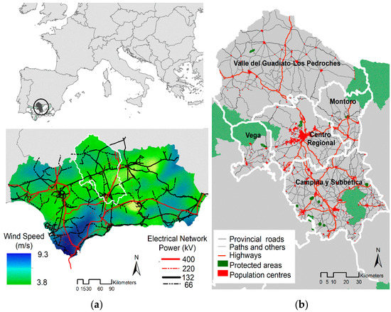
Figure 1.
Study area: (a) Wind speeds for a turbine height of 120 m and electrical network in Andalusia; (b) territorial units, protected areas, population centers, and road network in the province of Córdoba.
- Valle del Guadiato–Los Pedroches: traditionally a mining district, consisting of small villages and including large forested and agricultural areas. The area contains a smaller part of the Sierra de Hornachuelos Natural Park.
- Vega: characterized by fertile agricultural land and irrigated agricultural landscapes. This unit contains most of the Sierra de Hornachuelos Natural Park.
- Centro Regional: characterized by urban structures typical of regional centers. This territorial unit includes the city of Córdoba, capital of the province.
- Campiña y Subbética: characterized by agricultural land planted with cereals, olive trees, and vines. It hosts the Sierras Subbéticas Natural Park, as well as a large number of ecologically rich wetlands. It contains significant agrotowns characterized by slightly positive demographic dynamics.
- Montoro: a slightly more diversified landscape, but largely based on the alternation of dryland agriculture and olive-tree groves. It hosts the Cardeña y Montoro Natural Park.
The province of Córdoba is the only one of Andalusia’s 8 provinces where no wind turbines exist to date. According to the report “Informe de las infraestructuras energéticas de la provincia de Córdoba”, published by the Andalusian Energy Agency, which outlines the guidelines of the Andalusian government’s energy policy: “Wind resources in Córdoba are lacking; as a result, no wind turbines are currently in operation in the province” [32].
2.2. Materials and Software Used
For site selection of potential wind farms in the province of Córdoba, spatial data are available at the Institute of Statistics and Cartography of Andalusia and the Environmental Information Network of Andalusia, the bodies in charge of elaborating and distributing sociodemographic and environmental information at the regional level. Concerning wind-energy resources, the 50 m resolution grid of wind speed (for a turbine height of 120 m) was based on results published by project Minieolica [34]. This grid was used for a similar work in the province of Cádiz [31].
The digitalization (x, y) of wind turbines already in operation in the region, which was used for the setup of Scenario 3, was carried out using the 1977, 2001, 2007, 2009, 2011, and 2013 aerial orthophoto data, stored in the Infrastructure for Spatial Data in Andalusia. This infrastructure uses international standards to integrate interoperable geoservices, following the guidelines outlined in the Infrastructure for Spatial Information in Europe (INSPIRE) Directive [35].
Concerning the GIS used, this study was carried out with ArcGIS 10.3 software, which has been of enormous assistance, owing to the use of the Spatial Analysis extension and the Model Builder tool, a complex instrument that can be valuable in managing the large number of mathematical operations involved in finding locations that meet a series of criteria and in projecting the results cartographically and statistically.
Finally, the coordinate system used is the one determined by the legal framework [36], namely, the European Terrestrial Reference System 1989 (ETRS89), UTM zone 30 N (EPSG25830); the resolution of the maps is 100 m2.
2.3. Methodology
The methodology adopted to evaluate the presence of suitable areas for the installation of wind turbines in Córdoba is based on the construction of a locational model that combines the GIS and multicriteria evaluation methods. Three stages can be distinguished (Figure 2):
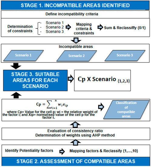
Figure 2.
Methodology workflow.
• Stage 1. Identification of areas that are incompatible with the installation of wind turbines.
Incompatibility criteria must be determined and the associated restrictions defined. As restrictions and legal frameworks vary from case to case, 3 different scenarios were outlined. Following Díaz-Cuevas et al. [31], the first scenario applied either the restrictions imposed by the legal and planning frameworks in force in the area under study or, if the legal framework makes no provision in this regard, the least restrictive conditions established by the existing literature. The second scenario, in contrast, applied the most restrictive conditions established in the literature adopting the precautionary principle [31,37,38,39]. Finally, the third scenario applies restrictions based on wind turbines, a method being pioneered by the present study.
• Stage 2. Assessment of the compatible areas.
Potentiality factors were defined and relative weights assigned by a panel of experts. In order to avoid inconsistency in these judgements, weights were determined using Saaty’s hierarchical analytical method [17,18]. Once the weights were determined, the compatibility of territorial units was determined by means of a weighted linear sum.
• Stage 3. Determination of the most suitable areas for the installation of wind farms.
Compatibility and suitability results were combined in order to define which areas would be most suitable for the installation of wind farms.
Each of these steps and substeps is explained in detail in the following sections.
2.3.1. Determination of Incompatible Areas
Identifying incompatible areas involves the defining incompatibility criteria and their associated restrictions. Table 1 illustrates the compatibility criteria and restrictions used to define each scenario. Restrictions have been defined based on different sources. In the first scenario, restrictions are largely based on the legal framework, and where this framework does not cover a certain criterion, minor restrictions based on the existing literature have been incorporated. The second scenario is based on the application of major constraints defined in the existing literature. In both cases, restrictions and criteria were reviewed based on similar studies published in the last 5 years. We chose to limit the review to studies published within this period because, although studies concerning the location of wind turbines go back further, older studies are concerned with wind turbines with different technical specifications and impact compared to more up-to-date models. For instance, technological improvements to blades have greatly reduced noise pollution in recent years. Similarly, new turbines are taller and more powerful, making their installation viable even in areas where wind resources are scarce.

Table 1.
Criteria and restrictions for each scenario.
In the third scenario, restrictions are based on wind turbines already in operation in Andalusia. All wind turbines in operation in Andalusia installed prior to 2014 (when the last series of orthophotos were taken) have been digitized. In addition to location data (x, y), further information, such as installation year and power output, has also been included in the database. This is a significant step forward in our understanding of wind energy in Andalusia; for instance, the new location data allow for more precise analyses to be carried out concerning the visual impact of wind turbines (location data available to date were limited to the central point of the wind farms, not to individual turbines) (Figure 3a).
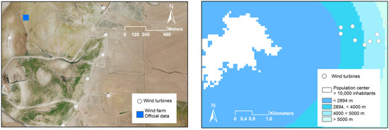
Figure 3.
(a) Wind turbines digitized by the author; (b) wind turbines and distance from population centers with >10,000 inhabitants.
Once the existing wind turbines were digitalized, the incompatibility criteria were applied to each of them. This was possible with the assistance of GIS tools, specifically the ArcGIS tool Extract Multi Values to Points, which allows for the computation of cell values for one or more rasters; in this case, in relation to incompatibility criteria. For instance, it was found that the minimum distance between existing wind turbines and population nuclei with over 10,000 inhabitants was 2893 m, which was thereafter applied as the restriction for the appropriate criterion in Scenario 3 (Figure 3b).
Figure 4 illustrates average wind speed and wind turbines in operation in Andalusia up to 2013. Of the 2060 wind turbines in operation (distributed among 147 wind farms), only those installed after 2008 (a total of 907) were taken into consideration (44% of the total). This is because the installation of wind turbines began in Andalusia a good while ago—the first wind turbine was installed in the municipality of Tarifa (Cádiz), with an average power of 150–300 kV, in 1983—and older wind turbines require the application of different restrictions and criteria.
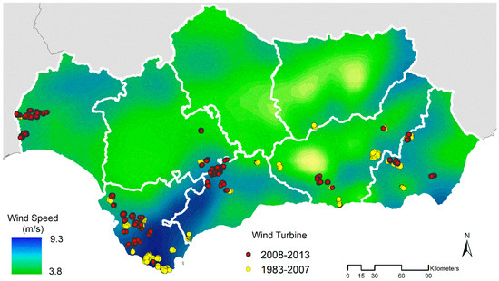
Figure 4.
Wind speeds for a turbine height of 120 m and wind turbines in Andalusia.
Once the criteria and restrictions had been defined, these were calculated and spatially represented by means of the GIS. Incompatible areas were assigned a value of 0, and compatible areas a value of 1. Afterwards, the resulting cartographies were combined, which resulted in the definition of incompatible areas (value 0) for each scenario.
2.3.2. Assessment of Compatible Areas
Once incompatible areas were defined, the next step was to divide the province into different areas according to their wind energy potential. In order to do this, 5 factors were defined and weighted by a group of experts comprising 4 postdoctoral researchers who knew the area under analysis, and 2 engineers who were familiar with the region’s features.
Weights were established with the assistance of Saaty’s hierarchical analytical method [17,18], which is commonly used in location models of this kind; the method is simple, does not require complex mathematical calculations [48], and allows for the mathematical representation of both qualitative and quantitative criteria.
The pairwise comparison of factors and qualitative judgments is expressed on the Saaty semantic scale (Table 2), which determines to what extent a given criterion is relatively more important than another one. The result is expressed by Matrix (1), where a given element is equivalent to itself, for instance 1, and the value of each element with regard to element is reciprocal to the value of each element with regard to element .
Table 2.
Saaty scale.
Once weights were assigned, the following step was taken to guarantee internal coherence of the decision-maker’s judgments, by calculating the consistency ratio (Cr) using Equations (2) and (3). If Cr > 0.10, the ratio values are indicative of inconsistent judgments and need to be revised.
where Ci is the consistency index, Ri is the random index, n is the number of variables in the comparison matrix (5 in this case), and λ is the value of the main normalized eigenvector W multiplied by the pairwise comparison matrix.
The random index (Ri) is the Ci of a randomly generated pairwise comparison matrix of an order of 1 to 10, obtained by approximating random indices using a sample size of 500 [17,18]. The Ri value for a matrix with 5 variables is 1.12.
As shown in Table 3, the experts considered that the restrictions applied to each scenario guaranteed the protection of population centers and natural and historical heritage items, and therefore focused on territorial features in order to optimize energy resources and territorial efficiency. As such, and following previous experiences [15,40,41], the availability of wind resources followed by the slope and the distance to the electricity grid were regarded as the most important criteria, while proximity to roads and populated nuclei received lower scores.
Table 3.
Pairwise comparison matrix.
Once weights had been assigned, potentiality factors were spatially represented and classified in quantiles (from 1 to 10); the value 10 was assigned to areas with the highest wind speed and least slope, which were closest to the electricity grid, the road network, and population nuclei (Figure 5). These values were then multiplied by their respective weights and added up. Incompatible areas were eliminated from the resulting maps.
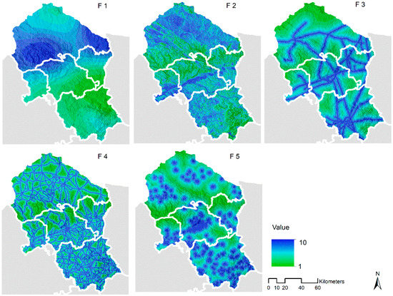
Figure 5.
Area maps for each factor. F1: highest wind speed; F2: least slope; F3: proximity to the electric grid; F4: proximity to the road network; F5: proximity to urban nuclei.
2.3.3. Suitability Areas
At this stage, in order to calculate the areas of the province that are most suitable for wind generation, incompatible areas in each scenario, which were assigned a value of 0, were multiplied by the compatible areas and classified according to their potential for wind generation (Equation (4)).
where S is suitability areas, S(1,2,3) is incompatible areas in each scenario, and Cp is compatible areas.
3. Results
3.1. Incompatible Areas
Figure 6 illustrates the areas in the province of Córdoba that are incompatible with wind-energy generation. In Scenario 1, incompatible areas cover 47% of the province, and in Scenario 3, 62% (6440 and 8575 km2, respectively); in Scenario 2, the whole province is regarded as incompatible. This is largely due to substantial restrictions applied to rivers, lagoons, and protected spaces, as well as restrictions aimed at public protection, for instance, airport buffer zones. For instance, around 99.99% of the territory of the province is within 3 km of a river or lagoon (the most restrictive criterion found in the existing literature); the minimum distances applied in Scenarios 1 and 3 are much less restrictive (50 and 100 m, respectively).
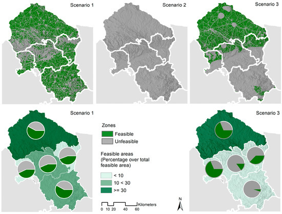
Figure 6.
Compatible and incompatible areas in Scenarios 1, 2, and 3.
Following the previous exercise, Figure 7 illustrates the areas that are compatible with the installation of wind turbines based on wind-energy criteria in each scenario. All areas have an average wind speed over 4.5 m/s, so all are suitable in this regard in Scenario 1. In Scenarios 2 and 3, the suitable area decreases substantially. Although this analysis challenges the idea that no wind farms exist in the province of Córdoba because available wind resources are insufficient, we must admit that this belief is not entirely unsubstantiated; an analysis of wind turbines already in operation in Andalusia since 2008 (Table 4) demonstrates that 67% of turbines (600) are located in areas where the average wind speed is in an excess of 6.6 m/s (the maximum average wind speed attested in Córdoba).
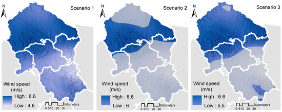
Figure 7.
Wind-energy constraints in Scenarios 1, 2, and 3.
Table 4.
Number and percentage of wind turbines in operation according to average wind speed.
In Scenario 1, 54% of the province is suitable in terms of wind resources, whereas in Scenario 3, only 37.5% is suitable. The territorial distribution of these areas is as follows: the territorial unit with the most suitable areas is Valle del Guadito–Los Pedroches, which encompasses approximately 30% of the suitable areas in both Scenarios 1 and 3; this area also registers the highest average wind speeds. Therefore, along with the northern areas of territorial units Montoro, Centro Regional, and La Vega–Bajo Guadalquivir, more detailed analyses beyond the scope of this study (including, for instance, such variables as social acceptance) should focus on this territorial unit.
3.2. Areas with the Highest Potential
Figure 8 illustrates, for Scenarios 1 and 3, compatible areas classified by potential. In both scenarios, the highest potential value is 9.84. However, while 1268.3 km2 (17% of the feasible territory in the province) has a potential value over 7 in Scenario 1, in Scenario 3 this increases to 1334.1 km2 (26%).
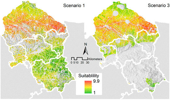
Figure 8.
Suitability areas in Scenarios 1, 2, and 3.
Concerning the distribution of these areas, territorial unit Valle del Guaditato–Los Pedroches hosts the most highly suitable areas (>7). This is a result of all five potentiality factors converging in this territorial unit (areas with the highest wind-resource availability, least slope, best proximity to the electric grid) (Figure 7), which amounts to 99% of the expert-assigned weight. This area includes the municipalities of Espiel, Hinojosa de Duque, and Pozoblanco. Therefore, these municipalities should be the subjects of more detailed analysis, for instance, to evaluate the potential impact of wind turbines on bird populations.
4. Discussion
The identification of optimum sites for the construction of renewable energy plants has been subject to intensive research in recent years, and is especially important in Spain and Andalusia, where, following European guidelines, important efforts are being made to promote these energy sources [49,50]. Often, this has led to the definition of broad political targets, which sometimes have not been preceded by preliminary evaluations of the region’s actual potential [39].
It is rare for either compatibility criteria or the restrictions that correspond to them to be defined in the legal framework of a given territory. Various studies establish their own incompatibility criteria or do not clarify the source of the criteria being applied; others simply adopt the criteria established by other authors in different territorial contexts [26,27,31]. However, it is important to recognize that this may lead to erroneous conclusions, because criteria and thresholds should directly relate to the characteristics of a specific territory. For this reason, criteria developed in other study areas should be applied with extreme care and must be evaluated not merely by experts in this field of study, but also by specialists who are familiar with the area under scrutiny, especially when the legal framework in force in the area does not define which criteria are to be applied. For instance, if the restrictions established by Baris et al. [42] upon rivers and bodies of water were to be applied in the province of Córdoba, the whole territory would be regarded as incompatible.
In these cases, it is important not to give a single perspective on the territory, but to present a wider array of alternatives by defining different restriction-based scenarios. Based on this idea, three different scenarios were defined for the installation of wind farms in the province of Córdoba. Scenario 1 applies the least restrictive suitability criteria (based on the territorial-planning documents and legal framework currently in force, and on the existing literature when the legal framework offers no guidance); Scenario 2 applies the most restrictive suitability criteria (again taken from the existing literature); and Scenario 3 applies the same restrictions that are in operation in already existing wind farms in the region of Andalusia. Scenario 3 is particularly important, as it allows for the evaluation of some of the restrictions applied in the other two scenarios. Data analysis concerning existing wind turbines indicates that wind turbines are in operation within 100 m of a river or body of water, which suggests that, although the related restriction in Baris et al. [42] may be being applied in their area of analysis, it is not in the province of Córdoba. Similarly, if Rodman and Meentemeyer’s [19] wind-speed criteria were to be applied to Córdoba (these authors argue against installing wind turbines in areas with an average wind speed below 7 m/s), there would be no suitable areas in the whole province. According to Scenario 3, however, 297 of the wind turbines in Andalusia in operation by 2013 (32.7% of the total) are located in areas that register an average wind speed of 6.6 m/s or less.
Concerning the suitability of the province of Córdoba for the installation of wind farms, according to Díaz et al. [51], it is necessary to keep in mind that these results are only valid for a general scale of analysis. After this first evaluation, more detailed analyses must be undertaken including further suitability criteria that should apply at the subregional or local level, for instance, social acceptance or impact on bird and bat populations. However, these general evaluations can be a valuable tool to facilitate decision making for both planners and investors.
Finally, contrary to assertions published by the Agencia Andaluza de la Energía, which regards the province of Córdoba as unsuitable for wind-energy generation owing to a lack of wind [32], the results of this study suggest that there are suitable areas in the province in all three scenarios. However, these are only general results that must be further contextualized to their own scale of analysis; as pointed out by Izquierdo [52], the accurate assessment of wind resources requires rigorous onsite testing to be carried out over a period of at least a year, followed by equally rigorous analysis of the data [31].
5. Conclusions
This research proposed a comprehensive GIS-based site-selection methodology for the installation of wind-power plants in the province of Córdoba, a territory that, a priori, was considered unsuitable for this sort of facility. Three scenarios were generated based on different sets of restrictions on compatibility criteria, based, in turn, on a review of the existing literature, planning policies, the legal framework of the area under scrutiny, and the criteria being applied to wind turbines already in operation in Andalusia. To the author’s knowledge, this is the only study to apply restrictions based on existing wind turbines.
The results indicate that there is significant potential for the installation of wind turbines in the province. Locations with high potential are especially present in the territorial unit Valle de Guadiato–Los Pedroches, where a more detailed multiscale analysis of wind-energy potential should be undertaken. I also wish to emphasize that special care must be exercised in those territories in which the legal framework does not cover criteria of this sort. In these cases, the issue should be analyzed by subject specialists as well as experts familiar with the area under scrutiny, since local conditions bear heavily on the nature of restrictions. Similarly, it is recommended that several scenarios be created, thus avoiding a determinist approach. Multiple scenarios facilitate decision making for public and private agents, who have different scenarios from which to choose. It is important not to present a closed picture of the territory, but to open the range of possible outcomes.
The construction of these scenarios was assisted by a combination of the GIS and multicriteria evaluation methods. Especially valuable was the Model Builder tool, which allows models to not only be easily implemented, but also updated (for instance, if there are changes in the legal and planning framework that demands thresholds to be revised, if technological innovations change the threat levels posed by wind turbines, or if policy makers, investors, and society at large change their preferences concerning the weighting of criteria). In this case, however, it is of the greatest importance to use a method to ensure that the weights are consistently applied, which is why Saaty’s method plays such a central role in my methodology.
This methodology can be applied to other spatial contexts by adapting the criteria and restrictions to the relevant legal framework or policies. As such, the method can be directly extrapolated, provided that the necessary geographical data are available (such as information concerning wind resources and a high-resolution digital elevation model for heights and slopes). Similarly, the application of Scenario 3 demands that data be available for a sufficient sample of existing wind turbines.
Funding
This research received no external funding.
Conflicts of Interest
The author declares no conflict of interest.
References
- An Energy Policy for Europe. 2007. Available online: http://www.europarl.europa.eu/meetdocs/2004_2009/documents/com/com_com(2007)0001_/com_com(2007)0001_en.pdf (accessed on 17 October 2018).
- Limiting Global Climate Change to 2 C—The Way Ahead for 2020 and Beyond. 2007. Available online: https://eur-lex.europa.eu/legal-content/EN/ALL/?uri=CELEX%3A52007SC0008 (accessed on 17 October 2018).
- A Strategy for Smart, Sustainable and Inclusive Growth. 2010. Available online: https://eur-lex.europa.eu/LexUriServ/LexUriServ.do?uri=COM:2010:2020:FIN:EN:PDF (accessed on 17 October 2018).
- Energy Roadmap 2050. 2011. Available online: https://eur-lex.europa.eu/LexUriServ/LexUriServ.do?uri=COM:2011:0885:FIN:EN:PDF (accessed on 17 October 2018).
- Voivontas, D.; Assimacopolous, D.; Mourelatos, A.; Corominas, J. Evaluation of Renewable Energy Potential Using a GIS Decision Support. Syst. Renew. Energy 1998, 3, 333–344. [Google Scholar] [CrossRef]
- Domínguez, J.; Amador, J. Geographical Information Systems applied in the field of the renewable energy sources. Comput. Ind. Eng. 2007, 52, 322–336. [Google Scholar] [CrossRef]
- Angelis-Dimakis, A.; Biberacher, M.; Dominguez, J.; Fioresse, G.; Gadocha, S.; Gnansounou, E.; Guariso, G.; Kartalidis, A.; Panichelli, L.; Pinedo, I.; Robba, M. Methods and tools to evaluate the availability of renewable energy sources. Renew. Sustain. Energy Rev. 2011, 15, 1182–1200. [Google Scholar] [CrossRef]
- Mourmouris, J.C.; Potolias, C. A multi-criteria methodology for energy planning and developing renewable energy sources at regional level: A case study Thassos, Greece. Energy Policy 2013, 52, 522–530. [Google Scholar] [CrossRef]
- Resch, B.; Sagl, G.; Törnros, T.; Bachmaier, T.; Eggers, J.B.; Herkel, S.; Narmsara, S.; Gündra, H. GIS-based planning and modeling for renewable energy: Challenges and Future Research Avenues. Int. J. Geo-Inf. 2014, 3, 662–692. [Google Scholar] [CrossRef]
- Baban, S.M.J.; Parry, T. Developing and applying a GIS-assisted approach to locating wind farms in the UK. Renew. Energy 2001, 24, 59–71. [Google Scholar]
- Hansen, H.S. GIS-based multi-criteria analysis of wind farm development. In Proceedings of the ScanGIS’ 2005: 10th Scandinavian Research Conference on Geographical Information Sciences, Stockholm, Sweden, 13 June 2005; pp. 75–87. [Google Scholar]
- Yue, C.D.; Wang, S.S. GIS-based evaluation of multifarious local renewable energy sources: A case study of the Chigu area of southwestern Taiwan. Energy Policy 2006, 34, 730–742. [Google Scholar] [CrossRef]
- Tegou, L.; Polatidis, H.; Haralambopoulos, D.A. Environmental management framework for wind farm siting: Methodology and case study. J. Environ. Manag. 2010, 91, 2134–2147. [Google Scholar] [CrossRef]
- Al-Yahyai, S.; Charabi, Y.; Gastli, A.; Al-Badi, A. Wind farm land suitability indexing using multi-criteria analysis. Renew. Energy 2012, 44, 80–87. [Google Scholar] [CrossRef]
- Effat, A.H. Spatial modeling of optimum zones for wind farms using remote sensing and geographic information system, Application in the Red Sea, Egypt. J. Geogr. Inf. Syst. 2014, 6, 358–374. [Google Scholar] [CrossRef]
- Al-Shabeeb, A.R.; Al-Adamat, R.; Mashagbah, A. AHP with GIS for a preliminary site selection of wind turbines in the North West of Jordan. Int. J. Geosci. 2016, 7, 1208–1221. [Google Scholar] [CrossRef]
- Saaty, T.L. The Analytic Hierarchy Process; Mc GRAWHILL: New York, NY, USA, 1980. [Google Scholar]
- Saaty, T.L. Group Decision Making and the AHP; Springer: New York, NY, USA, 1989. [Google Scholar]
- Rodman, L.; Meentemeyer, R. A geographic analysis of wind turbine placement in Northern California. Energy Policy 2006, 34, 2137–2149. [Google Scholar] [CrossRef]
- Miller, A.; Li, R. A geospatial approach for prioritizing wind farm development in Northeast Nebraska, USA. Int. J. Geo-Inf. 2014, 3, 968–979. [Google Scholar] [CrossRef]
- van Haaren, R.; Fthenakis, V. GIS-based wind farm site selection using spatial multi-criteria analysis (SMCA): Evaluating the case for New York State. Renew. Sustain. Energy Rev. 2011, 15, 3332–3340. [Google Scholar] [CrossRef]
- Gorsevkski, P.V.; Cathcart, S.C.; Mirzaei, G.; Jamali, M.M.; Ye, X.; Gomezdelcampo, E. A group-based spatial decision support system for wind farm site selection in Northwest Ohio. Energy Policy 2013, 55, 374–385. [Google Scholar] [CrossRef]
- Szurek, M.; Blachowski, J.; Nowaka, A. GIS-based method for wind farm location multi-criteria analysisis. Min. Sci. 2014, 21, 65–85. [Google Scholar] [CrossRef]
- Panagiotidou, M.; Xydis, G.; Kooneos, C. Environmental Siting Framework for Wind Farms: A Case Study in the Dodecanese Islands. Resources 2016, 5, 24. [Google Scholar] [CrossRef]
- Latinopoulos, D.; Kechagia, K. A GIS-based Multi-criteria evaluation for wind farm site selection. A regional scale application in Greece. Renew. Energy 2015, 78, 550–560. [Google Scholar] [CrossRef]
- Höfer, T.; Sunak, Y.; Siddique, H.; Madlener, R. Wind farm siting using a spatial Analytic Hierarchy Process approach: A case study of the Städteregion Aachen. Appl. Energy 2016, 163, 222–243. [Google Scholar] [CrossRef]
- Sunak, Y.; Höfer, T.; Siddique, H.; Madlener, R.; De Doncker, R.W. A GIS-Based Decision Support System for the Optimal Siting of Wind Farm Projects; E.ON Energy Research Center Series and RWTH Aachen University: Aachen, Germany, 2015. [Google Scholar]
- Ramírez-Rosado, I.J.; García-Garrido, L.; Fernández-Jiménez, A.; Zorzano-Santamaria, P.; Monteiro, C.; Miranda, V. Promotion of new wind farms based on a decisión support system. Renew. Energy 2008, 33, 558–566. [Google Scholar] [CrossRef]
- Schallenberg- Rodríguez, J.; Notario-del Pino, J. Evaluation of on-shore wind techno-economical potential in regions and islands. Appl. Energy 2014, 124, 117–129. [Google Scholar] [CrossRef]
- Sánchez-Lozano, J.M.; García-Cascales, M.S.; Lamat, M.T. Identification and selection of potential sites for onshore wind farms development in Region of Murcia, Spain. Energy 2014, 73, 311–324. [Google Scholar] [CrossRef]
- Díaz-Cuevas, M.P.; Biberacher, M.; Domínguez-Bravo, J.; Schardinger, I. Developing a wind energy potential map on a regional scale using GIS and multi-criteria decision methods: The case of Cadiz (south of Spain). Clean Technol. Environ. Policy 2018, 20, 1167–1183. [Google Scholar] [CrossRef]
- Informe de Las Infraestructuras Energéticas de la Provincia de Córdoba. 2017. Available online: https://www.agenciaandaluzadelaenergia.es/sites/default/files/documentos/informe_prov_co_miea_2017_12_31.pdf (accessed on 17 October 2018).
- Plan de Ordenación Del Territorio de Andalucía. 2006. Available online: http://www.juntadeandalucia.es/medioambiente/portal_web/ot_urbanismo/ordenacion_territorio/pota/pota_completo.pdf (accessed on 17 October 2018).
- Lorente-Plazas, R.; Montávez, J.P.; Jerez, S.; Gómez-Navarro, J.J.; Jiménez-Guerrero, P.; Jiménez, P.A.; García-Valero, J.A.; Gomáriz-Castillo, F.; Alonso-Sarría, F. EOLMAP: A web tool to assess the wind resource over Spain. Renew. Energy Pow. Qual. 2012, 1, 1264–1269. [Google Scholar] [CrossRef]
- Directiva 2007/2/CE del Parlamento Europeo y del Consejo de 14 de marzo de 2007 por la que se Establece una Infraestructura de Información Espacial en la Comunidad Europea (Inspire). 2007. Available online: http://www.juntadeandalucia.es/medioambiente/web/aplicaciones/Normativa/ficheros/d2007_02_cee.pdf (accessed on 17 October 2018).
- Royal Decree 1071/2007, de 27 de Julio, Por el Que se Regula el Sistema Geodésico de Referencia Oficial en España. 2007. Available online: https://www.boe.es/buscar/doc.php?id=BOE-A-2007-15822 (accessed on 17 October 2018).
- Communication from the Commission on the Precautionary Principle. 2000. Available online: https://eur-lex.europa.eu/legal-content/EN/TXT/?uri=celex%3A52000DC0001 (accessed on 17 October 2018).
- Sliz-Szkliniarz, B.; Vogt, J. GIS-based approach for the evaluation of wind energy potential: A case study for the Kujawsko-Pomorskie Voivodeship. Renew. Sustain. Energy Rev. 2011, 15, 1696–1707. [Google Scholar] [CrossRef]
- Díaz-Cuevas, P. Energía eólica y Territorio. Potencialidades para la Implantación de Parques Eólicos en Andalucía. Ph.D. Thesis, University of Seville, Seville, Spain, 2013. [Google Scholar]
- Noorollahi, Y.; Youseffi, H.; Mohammadi, M. Multi-criteria decision support system for wind farm site selection using GIS. Sustain. Energy Technol. Assess. 2016, 13, 38–50. [Google Scholar] [CrossRef]
- Watson, J.J.W.; Hudson, M.D. Regional Scale wind farm and solar farm suitability assessment using GIS-assisted multi-criteria evaluation. Landsc. Urban Plan. 2015, 138, 20–31. [Google Scholar] [CrossRef]
- Baris, K.B.; Bahadir, S.; Ulucan, A.; Umur, M. A GIS-based multiple criteria decision analysis approach for wind power plant site selection. Util. Policy 2015, 3, 86–96. [Google Scholar] [CrossRef]
- Act 8/2001, de 12 de Julio, de Carreteras de Andalucía; Boletín Oficial Junta de Andalucía. 2001. Available online: https://www.juntadeandalucia.es/boja/2001/85/1 (accessed on 17 October 2018).
- Act 9/2006, de 26 de Diciembre, de Servicios Ferroviarios de Andalucía. 2006. Available online: https://www.juntadeandalucia.es/boja/2006/251/1 (accessed on 17 October 2018).
- Act 2/1989, de 18 de Julio, por la que se Aprueba el Inventario de Espacios Naturales Protegidos de Andalucía, y se Establecen Medidas Adicionales para su Protección. 1989. Available online: https://www.juntadeandalucia.es/boja/1989/60/1 (accessed on 17 October 2018).
- Act 4/1989, de 27 de marzo, de Conservación de los Espacios Naturales y de la Flora y Fauna Silvestre. 1989. Available online: http://noticias.juridicas.com/base_datos/Admin/l4-1989.html (accessed on 17 October 2018).
- Grass, V.; Schmidt, J.; Strauss, F.; Schmid, E. Assessing the economic wind power potential in Austria. Energy Policy 2013, 53, 323–330. [Google Scholar] [CrossRef]
- Kumar, A.; Sah, B.; Singh, A.; Denga, Y.; Hea, H.; Kumarb, P.; Bansald, R.C. A review of multi criteria decision making (MCDM) towards sustainable renewable energy development. Renew. Sustain. Energy Rev. 2016, 69, 596–609. [Google Scholar] [CrossRef]
- Prados, M.J. Renewable energy policy and landscape management in Andalusia, Spain: The facts. Energy Policy 2007, 8, 6900–6909. [Google Scholar] [CrossRef]
- Estrategia Energética de Andalucía 2020; Consejería de Empleo 2016. Available online: https://www.agenciaandaluzadelaenergia.es/sites/default/files/documentos/estrategia-andalucia-2020.pdf (accessed on 17 October 2018).
- Díaz Cuevas, M.P.; Pita López, M.F.; Fernández Tabales, A.; Limones Rodríguez, N. Energía eólica y territorio en Andalucía: Diseño y aplicación de un modelo de potencialidad para la implantación de parques eólicos. Investig. Geogr. 2017, 67, 9–29. [Google Scholar] [CrossRef]
- Izquierdo, J.M. Energía Eólica y Territorio; Universidad de Sevilla: Seville, Spain, 2008. [Google Scholar]


© 2018 by the author. Licensee MDPI, Basel, Switzerland. This article is an open access article distributed under the terms and conditions of the Creative Commons Attribution (CC BY) license (http://creativecommons.org/licenses/by/4.0/).