
Wind Farm Location Special Optimization Based on Grid GIS and Choquet Fuzzy Integral Method in Dalian City, China


Abstract
:1. Introduction
2. Methodology
2.1. The Concept of the λ Fuzzy Measure
- (a)
- ;
- (b)
- if then , for any ;
- (c)
- where for E, F ∈ P(A) andwhere IR is the power set of P(A), gλ(S) denotes the importance or weight of the set of index , or the capability of S to find out the wind farm optimal location without considering any remaining indexes; and g is the gλ fuzzy measure. If set A = {a1, a2, …, am} is finite, the mapping ai →gi(ai), i = 1, 2, …, m is the fuzzy density function, and can be formulated as follow:
2.2. Choquet Fuzzy Integral Method
2.3. The Determination of λ Fuzzy Measure
2.4. Natural Breaks
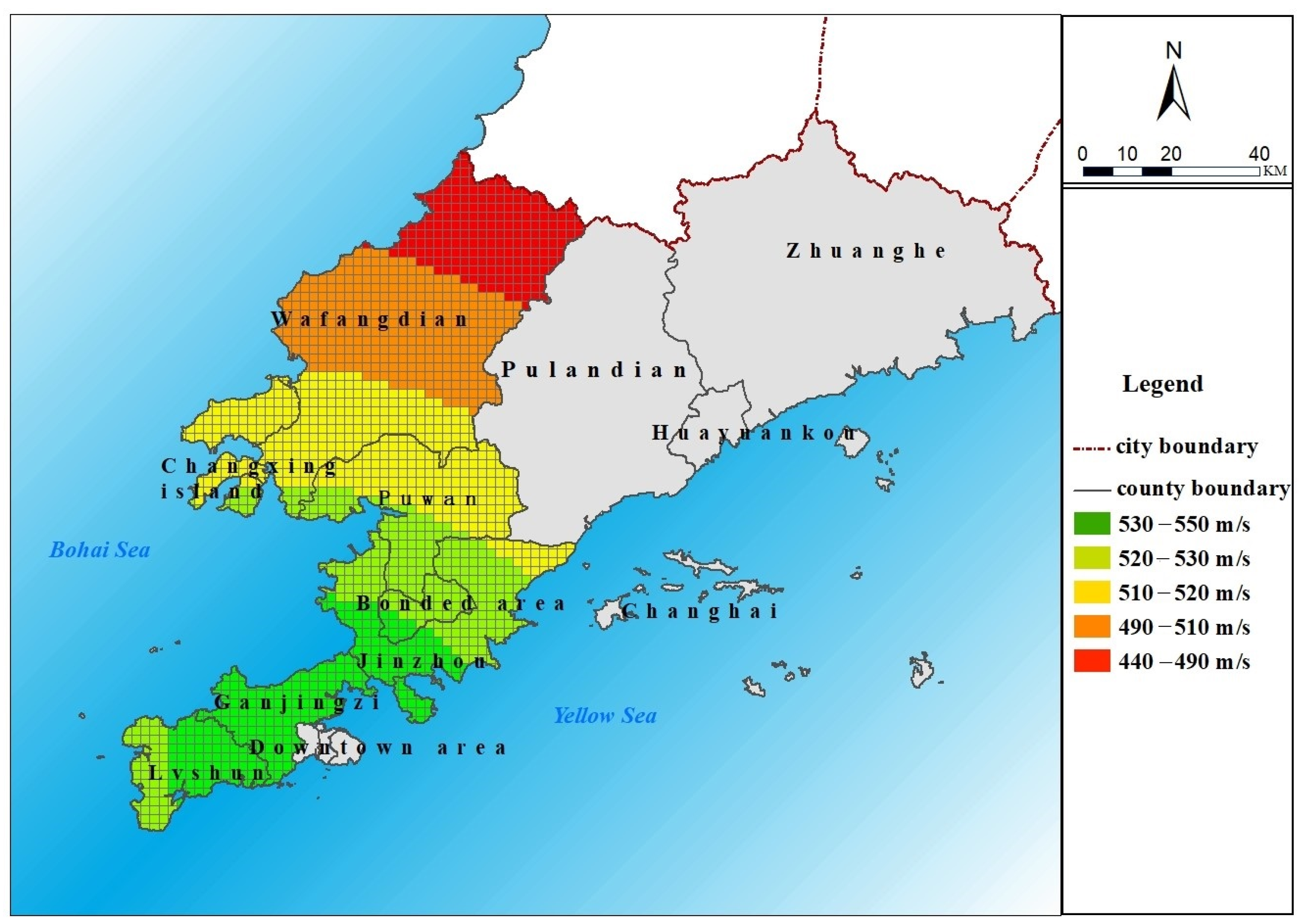
3. Study Area
4. The Frame Work of the Wind Farm Location Special Optimization Model
- Step 1: Build the grid cells in the study area.
- Step 2: Build the index system for wind farm location optimization system to the study area.
- Step 3: Calculate each index of each grid cell, and take the gird cell as the wind farm alternative.
- Step 4: Standardized the values of index.
- Step 5: Calculate the importance of index according to Formulas (3) and (4).
- Step 6: Determine the λ fuzzy measure of the index based on Model (5).
- Step 7: Value wind farm potential location based on the Choquet integral according to Equation (2) and determines the optimal grid for the wind farm location.
5. Results and Discussion
5.1. Determine the Shapley Value and Fuzzy Measures
5.2. Wind Farm Location Based on Shapley Value
5.3. The Optimal Wind Farm Location Based on Choquet Fuzzy Integral Method
6. Conclusions
Author Contributions
Funding
Institutional Review Board Statement
Informed Consent Statement
Data Availability Statement
Acknowledgments
Conflicts of Interest
References
- Kan, S.Y.; Chen, B.; Chen, G.Q. Worldwide energy use across global supply chains: Decoupled from economic growth. Appl. Energy 2019, 250, 1235–1245. [Google Scholar] [CrossRef]
- BP. BP Statistical Review of World Energy 2018; BP: UK, London, 2018. [Google Scholar]
- Perera, A.T.D.; Vahid, M.N.; Chen, D.; Scartezzini, J.L.; Hong, T.Z. Quantifying the impacts of climate change and extreme climate events on energy systems. Nat. Energy 2020, 5, 150–159. [Google Scholar] [CrossRef] [Green Version]
- Lu, Y.; Sun, L.; Xue, Y. Research on a Comprehensive Maintenance Optimization Strategy for an Offshore Wind Farm. Energies 2021, 14, 965. [Google Scholar] [CrossRef]
- Shin, J.; Baek, S.; Rhee, Y. Wind Farm Layout Optimization Using a Metamodel and EA/PSO Algorithm in Korea Offshore. Energies 2021, 14, 146. [Google Scholar] [CrossRef]
- Ziemba, P. Multi-Criteria Fuzzy Evaluation of the Planned Offshore Wind Farm Investments in Poland. Energies 2021, 14, 978. [Google Scholar] [CrossRef]
- Latinopoulos, D.; Kechagia, K. A GIS-based multi-criteria evaluation for wind farm site selection. A GIS-based multi-criteria evaluation for wind farm site selection. A regional scale application in Greece. Renew. Energy 2015, 78, 550–560. [Google Scholar] [CrossRef]
- Nezhad, M.M.; Neshat, M.; Heydari, A.; Razmjoo, A.; Garcia, D.A. A new methodology for offshore wind speed assessment integrating sentinel-1, era-interim and in-situ measurement. Renew. Energy 2021, 172, 1301–1313. [Google Scholar] [CrossRef]
- Neshat, M.; Nezhad, M.M.; Abbasnejad, E.; Groppi, D.; Wagner, M. Hybrid Neuro-Evolutionary Method for Predicting Wind Turbine Power Output. Res. Gate 2020. [Google Scholar] [CrossRef]
- Mytilinou, V.; Kolios, A.J. Techno-economic optimisation of offshore wind farms based on life cycle cost analysis on the UK. Renew. Energy 2019, 132, 439–454. [Google Scholar] [CrossRef]
- Nezhad, M.M.; Neshat, M.; Groppi, D.; Marzialetti, P.; Heydari, A.; Sylaios, G.; Garcia, D.A. A primary offshore wind farm site assessment using reanalysis data: A case study for Samothraki Island. Renew. Energy 2021, 172, 667–679. [Google Scholar] [CrossRef]
- Behera, S.; Sahoo, S.; Pati, B.B. A review on optimization algorithms and application to wind energy integration to grid. Renew. Sustain. Energy Rev. 2015, 48, 214–227. [Google Scholar] [CrossRef]
- Mehmet, K.; Metin, D. Prioritization of renewable energy sources for Turkey by using a hybrid MCDM methodology. Energy Convers. Manag. 2014, 79, 25–33. [Google Scholar]
- Fetanat, A.; Khorasaninejad, E. A novel hybrid MCDM approach for offshore wind farm site selection: A case study of Iran. Ocean Coast. Manag. 2015, 109, 17–28. [Google Scholar] [CrossRef]
- Hu, J.; Harmsen, R.; Crijns-Graus, W.; Worrell, E. Geographical optimization of variable renewable energy capacity in China using modern portfolio theory. Appl. Energy 2019, 253, 113614. [Google Scholar] [CrossRef]
- Aydin, N.Y.; Kentel, E.; Duzgun, S. GIS-based environmental assessment of wind energy systems for spatial planning: A case study from Western Turkey. Renew. Sustain. Energy Rev. 2010, 14, 364–373. [Google Scholar] [CrossRef]
- Baban, S.M.J.; Parry, T. Developing and applying a GIS-assisted approach to locating wind farms in the UK. Renew. Energy 2001, 36, 1125–1132. [Google Scholar] [CrossRef]
- Haaren, R.; Fthenakis, V. GIS-based wind farm site selection using spatial multi-criteria analysis (SMCA): Evaluating the case for New York State. Renew. Sustain. Energy Rev. 2011, 15, 3332–3340. [Google Scholar] [CrossRef]
- Omitaomu, O.A.; Blevins, B.R.; Jochem, W.C.; Mays, G.T.; Belles, R.; Hadley, S.W.; Harrison, T.J.; Bhaduri, B.L.; Neish, B.S.; Rose, A.N. Adapting a GIS-based multicriteria decision analysis approach for evaluating new power generating sites. Appl. Energy 2012, 96, 292–301. [Google Scholar] [CrossRef]
- Baseer, M.A.; Rehman, S.; Meyer, J.P.; Alam, M.M. GIS-based site suitability analysis for wind farm development in Saudi Arabia. Energy 2017, 141, 1166–1176. [Google Scholar] [CrossRef] [Green Version]
- Konstantinos, I.; Georgios, T.; Garyfalos, A. A Decision Support System methodology for selecting wind farm installation locations using AHP and TOPSIS: Case study in Eastern Macedonia and Thrace region, Greece. Energy Policy 2019, 132, 232–246. [Google Scholar] [CrossRef]
- Spyridonidou, S.; Vagiona, D.G. Spatial energy planning of offshore wind farms in Greece using GIS and a hybrid MCDM methodological approach. Int. J. Integr. Eng. 2020, 12, 294–301. [Google Scholar] [CrossRef]
- Wang, J.J.; Jing, Y.Y.; Zhang, C.F.; Zhao, J.H. Review on multi-criteria decision analysis aid in sustainable energy decision-making. Renew. Sustain. Energy Rev. 2009, 13, 2263–2278. [Google Scholar] [CrossRef]
- Zhang, L.; Zhou, P.; Newton, S.; Fang, J.X.; Zhou, D.Q.; Zhang, L.P. Evaluating clean energy alternatives for Jiangsu, China: An improved multi-criteria decision making method. Energy 2015, 90, 953–964. [Google Scholar] [CrossRef]
- Grabisch, M.; Labreuche, C. A decade of application of the Choquet and Sugeno integrals in multi-criteria decision aid. Ann. Oper. Res. 2010, 175, 47–286. [Google Scholar] [CrossRef]
- Grabisch, M. The application of fuzzy integrals in multicriteria decision making. Eur. J. Oper. Res. 1996, 89, 445–456. [Google Scholar] [CrossRef]
- Greco, S.; Rindone, F. Bipolar fuzzy integrals. Fuzzy Sets Syst. 2013, 220, 21–33. [Google Scholar] [CrossRef] [Green Version]
- Jang, L.C. A note on the interval-valued generalized fuzzy integral by means of an interval-representable pseudo-multiplication and their convergence properties. Fuzzy Sets Syst. 2013, 222, 45–57. [Google Scholar] [CrossRef]
- Marichal, J.L. An axiomatic approach of the discrete Choquet integral as a tool to aggregate interacting criteria. IEEE Trans. Fuzzy Syst. 2000, 8, 800–807. [Google Scholar] [CrossRef] [Green Version]
- Liu, X.; Ma, L.; Mathew, J. Machinery Fault Diagnosis Based On Fuzzy Measure and Fuzzy Integral Data Fusion Techniques. Mech. Syst. Signal Process. 2009, 23, 690–700. [Google Scholar] [CrossRef]
- Sugeno, M. Theory of Fuzzy Integral and Its Applications. Ph.D. Thesis, Department of Comp Intell & SystSci, Tokyo Institute of Technology, Tokyo, Japan, 1974. [Google Scholar]
- Hu, Y.C. Fuzzy integral-based perceptron for two-class pattern classification problems. Inf. Sci. 2007, 177, 1673–1686. [Google Scholar] [CrossRef]
- Grabidch, M. k-order addtive discrete fuzzy measures and their representation. Fuzzy Sets Syst. 1997, 92, 167–189. [Google Scholar] [CrossRef]
- Marichal, J.L. Entropy of discrete Choquet capacities. Eur. J. Oper. Res. 2002, 137, 612–624. [Google Scholar] [CrossRef] [Green Version]
- Jenks, G.F. Optimal Data Classification for Choropleth Maps; Department of Geography Occasional, University of Kansas: Lawrence, KS, USA, 1977; No. 2. [Google Scholar]
- Yu, X.; Qu, H. Wind power in China—opportunity goes with challenge. Renew. Sustain. Energy Rev. 2010, 14, 2232–2237. [Google Scholar] [CrossRef]
- Zhao, B.; Wang, N.; Fu, Q.; Yan, H.K. Searching a site for a civil airport based on ecological conservation: An expert-based selection (Dalian, China). Glob. Ecology Conserv. 2019. [Google Scholar] [CrossRef]
- Fu, Q.; Wang, N.; Shen, M.Q.; Song, N.Q.; Yan, H.K. A study of the site selection of a civil airport based on the risk of bird strikes: The case of Dalian, China. J. Air Transp. Manag. 2016, 54, 17–30. [Google Scholar] [CrossRef]


| First Level Index | Second Level Index | Third Level Index |
|---|---|---|
| Natural factors | Typography | Altitude |
| Slope | ||
| Meteorological | Accumulated wind speed | |
| Socio-economic factors | Transmission facilities | Distances to roads |
| Transmission lines | ||
| Biological passage | Bird way | |
| Bird sanctuary | ||
| Infrastructure | Building area | |
| Power plant | ||
| Chemical plant |
| First Level Index | Shapley Value | Second Level Index | Shapley Value |
|---|---|---|---|
| Natural factors | 0.8 | Typography | 0.125 |
| Meteorological | 0.875 | ||
| Socio-economic factors | 0.2 | Transmission facilities | 0.264 |
| Biological passage | 0.055 | ||
| Infrastructure | 0.681 |
| First Level Index | Second Level Index | Third Level Index | λ Fuzzy Measure | λ Value |
|---|---|---|---|---|
| Natural factors | Typography | Altitude | 0.491 | 0.075 |
| Slope | 0.491 | |||
| Meteorological | Accumulated wind speed | 0.870 | ||
| Socio-economic factors | Transmission facilities | Distances to roads | 0.167 | 0.000 |
| Transmission lines | 0.833 | |||
| Biological passage | Bird way | 0.491 | 0.075 | |
| Bird sanctuary | 0.491 | |||
| Infrastructure | Building area | 1.000 | 0.344 | |
| Power plant | 0.133 | |||
| Chemical plant | 0.047 |
| Very Suitable | Suitable | Commonly | Unsuitable | Very Unsuitable |
|---|---|---|---|---|
| 67.64 | 112.01 | 1420.69 | 1043.47 | 0.97 |
Publisher’s Note: MDPI stays neutral with regard to jurisdictional claims in published maps and institutional affiliations. |
© 2021 by the authors. Licensee MDPI, Basel, Switzerland. This article is an open access article distributed under the terms and conditions of the Creative Commons Attribution (CC BY) license (https://creativecommons.org/licenses/by/4.0/).
Share and Cite
Cui, L.; Xu, Y.; Xu, L.; Huang, G. Wind Farm Location Special Optimization Based on Grid GIS and Choquet Fuzzy Integral Method in Dalian City, China. Energies 2021, 14, 2454. https://doi.org/10.3390/en14092454
Cui L, Xu Y, Xu L, Huang G. Wind Farm Location Special Optimization Based on Grid GIS and Choquet Fuzzy Integral Method in Dalian City, China. Energies. 2021; 14(9):2454. https://doi.org/10.3390/en14092454
Chicago/Turabian StyleCui, Liang, Ye Xu, Ling Xu, and Guohe Huang. 2021. "Wind Farm Location Special Optimization Based on Grid GIS and Choquet Fuzzy Integral Method in Dalian City, China" Energies 14, no. 9: 2454. https://doi.org/10.3390/en14092454