Review

Gas Sources, Migration, and Accumulation Systems: The Shallow Subsurface and Near-Seafloor Gas Hydrate Deposits

1
Key Laboratory of Submarine Geosciences, Second Institute of Oceanography, Ministry of Natural Resources, Hangzhou 310012, China
2
Key Laboratory of Gas Hydrate, Ministry of Natural Resources, Qingdao Institute of Marine Geology, Qingdao 266237, China
3
Drilling Technology Research Institute of Shengli Petroleum Engineering Corporation Limited, SINOPEC, Dongying 257017, China
*
Authors to whom correspondence should be addressed.
Energies 2022, 15(19), 6921; https://doi.org/10.3390/en15196921
Submission received: 28 June 2022 / Revised: 7 August 2022 / Accepted: 30 August 2022 / Published: 21 September 2022

Abstract

:
Compared with the deeply buried marine gas hydrate deposits, gas hydrates in the shallow subsurface, close to and at the seafloor, have attracted more attention owing to their concentrated distribution, high saturation, and easy access. They accumulate at relatively shallow depths <100–120 m and occur as gas hydrate-bearing mounds (also known as hydrate outcrops, pingoes) at the seafloor derived from the growth of hydrates in the shallow subsurface or as pure hydrate chunks formed by gas leakage. This paper reviews and summarizes such gas hydrate systems globally from the perspective of gas sources, migration pathways, and accumulation processes. Here, we divided them into four categories: fault-chimney-controlled, diapir-fault-controlled, fault-controlled, and submarine mud volcano-controlled deposits. Gas chimneys originate immediately above the restricted regions, mostly affected by faults where high gas concentrations trigger elevated pore fluid pressures. Diapirism derives a dendritic network of growth faults facilitating focused gas discharge and hydrate formation near the seafloor. Furthermore, pre-existing faults or fractures created by overpressured gas from greater depths in accretionary tectonics at convergent margins act as preferential pathways channeling free gas upwards to the seafloor. Gas flux rates decrease from the submarine mud volcano center to its margins, creating a concentric pattern of distributing temperature, gas concentrations, and hydrate contents in shallow sediments around the mud volcano. Hydrate-bound hydrocarbons are commonly of thermogenic origin and correspond to high-background geothermal conditions, whereas microbial gas is dominant in a few cases. The presence of heavier hydrocarbons mitigates the inhibition of hydrate formation by salt or heat. Fluid migration and pathways could be compared to the “blood” and “bones” in an organic system, respectively. The root of a pathway serves as the “heart” that gathers and provides considerable free gas concentrations in a restricted area, thereby triggering pore fluid pressures as one important drive force for focused fluid flow in impermeable sediments (the organic system). Besides the suitable temperature and pressure conditions, a prerequisite for the formation and stability of hydrate deposits in the shallow subsurface and at the seafloor is the sufficient supply of gas-rich fluids through the hydrate stability zone. Thus, the proportion of gas migrating from deep sources is significantly larger than that trapped in hydrates. As such, such marine hydrate deposits seem more like temporary carbon storage rather than the main culprit for climate warming at least in a short period.

Graphical Abstract

1. Introduction

Most marine gas hydrate investigations over recent decades have revolved around the accumulations in deep marine subsurface sediments (100–400 m below the seafloor, mbsf). Actually, gas hydrates can form in shallow subsurfaces (less than 100–120 mbsf), near or at the seafloor (known as hydrate mounds, outcrops, or pingoes), where gas fluxes are unusually strong.
Diffusive flow and favorable reservoirs dominate the deep-buried marine hydrate [1,2]. Under appropriate temperature–pressure (P-T) conditions, the most common occurrence has been reported in the form of low-saturated disseminated deposits in fine-grain sediments [3]. Nevertheless, gas hydrates in the shallow subsurface and near the seafloor are typically thick and relatively pure [4], with outcrops, massive layers parallel to the bedding planes, grain-displacing types (nodules, veins, and fracture fills) [1,5]. Such reservoirs are inextricably linked with the gas–fluids accumulations and their focused flow through localized effective pathways toward the seafloor, leaving distinctive seismic reflection records [5]. Focused fluid movement produces bottom simulating reflections (BSRs) that are poorly developed, discrete, and/or upwarped [6]. Consequently, a simple probe guided by BSRs is very likely to miss such hydrate accumulation in conjunction with focused flow.
In this paper, we review the reported isolated marine gas hydrate systems in the shallow subsurfaces and near the seafloor at the global scale (Figure 1), including gas sources, migration pathways/conduits, and accumulations, and classify these hydrate deposits into four categories: fault-chimney-controlled, diapir-fault-controlled, fault-controlled, and mud volcano-controlled deposits, according to similar structural settings, tectonic controls, and seismic signatures. The purpose of this paper is not to provide an inventory. Rather, our primary objectives are to summarize the elements for each shallow subsurface and near-seafloor hydrate system from the available literature to determine whether some common regulations can be found. We hope that this work will at least provide an analog for future case studies and constrain models of gas hydrate deposits originating in similar geological settings.

2. Fault-Chimney-Controlled Deposits

One of the indicators of focused fluid flow features indicative of overpressurized formations in the subseabed is the seismic chimney. It has a roughly vertical cylindrical shape, which is defined by three-dimensional seismic amplitude contrasts between the conspicuous acoustic blanking and reflectors of adjacent sediments [7,8]. Chimney structures are typically found above the areas of strong deformation that are closely linked with faults, serving as an efficient conduit for enhanced fluids migration through impermeable sediment towards the seafloor. The fault-chimney-controlled shallow gas hydrate systems will be described in this section.

2.1. Joetsu Basin, Japan

Since the discovery of massive gas hydrates on mound-like topography in the Joetsu Basin (Figure 1) on the eastern margin of the Japan Sea in 2003, many investigations have been conducted to determine the origin of shallow hydrates, with a focus on Umitaka Spur and Joetsu Knoll, located 30 km offshore of the city of Joetsu [5,9].
Both the Spur and Knoll are anticlines of the Middle Pliocene [10]. NE–SW axial fault systems are observed in the centers of both anticlines [10]. Well-developed faulted-related chimneys exist in closely spaced areas along the Spur and Knoll crests, 0.2–3.5 km in diameter, under clusters of mounds and depression structures (0.3–0.5 km in diameter and 30–40 m in height or depth) [5,11]. Multiple Logging While Drilling (LWD) and seismic surveys have revealed the presence of massive and dense gas hydrates in chimneys above BSRs [9]. The Joetsu Basin’s predicted hydrate stability depth is 100–120 mbsf, with a bottom water temperature of 0.2–0.3 °C and thermal gradients of 100 °C/km, respectively [9,12,13].
Structural–stratigraphic features govern the formation of gas hydrates, gas chimneys, and seeps (Figure 2; [14]). In the Spur, faults connect the top of the Nishiyama Formation with the GHSZ (Figure 2). Notably, chimneys are typically found in areas most affected by faults and fractures, serving as effective gas migration conduits, enriching the GHSZ in the Haizume Formation with gas and hydrates [11,14]. The porous–permeable debris flow deposits on Umitaka Spur’s flanks are also potential hydrate deposits and free gas reservoirs beneath the GHSZ. In the context of the overall anticlinal structures, the tectonic compaction, combined with water release from thermal alteration of clays, causes fluid overpressure as the primary driving force for upward and lateral migration of fluids [15]. Fluid moving along fractures, faults, carrier beds, and depositional surfaces fuels chimneys in the anticline’s axial part (Figure 2).
Hydrate outcrops, mounds, and depression structures are found in the center of the Spur and Knoll, near the crest areas of chimneys located above the strongest fractured zones with the highest concentration of gas seeps [11,14]. The formation of gas hydrates near the seafloor increases the pore space volume of sediments, allowing for the uplift of older sediments and mound formation (Figure 3A,B; [9,10]). Meanwhile, erosion at mound tops prevents Holocene sediments from being deposited [10,14]. Inactive pockmark-like depression structures that accompany hydrate accumulations at shallow depths could be the result of hydrate block self-collapse and floating up (Figure 3C; [5,11]). The larger crater-like depressions (chimney collapse) were presumably caused by a large-scale dissociation of gas hydrates around the depth of the base of gas hydrate stability zone (BGHSZ) due to the drop in sea level during the LGM (Figure 3D,E), as evidenced by the presence of a black–dark laminated unit (27–18 ka BP) deposited in anoxic–euxinic conditions and benthic foraminifers with a sharp δ13C negative excursion toward ~21 ka BP (Figure 3E; [11]).
The Joetsu Basin’s major source of oil and gas is substantial organic matter rich in TOC (>2%) in Miocene and Pliocene sediments [5]. The Pliocene–Quaternary inversion tectonic process and high heat flow along the eastern margin of the young Japan Sea boost the thermal maturation of organic matter and allow deep-seated thermogenic gas to migrate through reactivated faults [5,14,16]. Shallow hydrate-bound gas is nearly 100% methane with a thermogenic δ13C signature of −30‰ to 50‰, whereas methane extracted from sediments with low fluxes far away from mounds shows δ13C values of −50‰ to 100‰, indicating a microbial origin [11]. According to geochemical results, such as halogens and 129I distributions and helium contents, gas hydrates within chimneys may have undergone a long-term process of melting and refreezing [10,13,17,18]. For example, originally formed hydrates dissociate at the BGHSZ, releasing helium sourced from fluids enriched in mantle gases, and refreeze in a massive form near the seafloor with relatively low helium content and retaining a mantle 3He/4He signature, resulting in the presence of high helium content in waters near gas plumes [13,19].
Approximately 2000 gas chimney structures have been identified along the Japan Sea’s eastern margins and around Hokkaido [9]. As a result of the advantages of high saturation and easy access, the thick and massive gas hydrates within chimney structures may become a large natural gas resource available in Japan in the near future.

2.2. Ulleung Basin, Korea

The Ulleung Basin offshore of Korea is composed primarily of mass-transport deposits (MTDs) and hemipelagic muds interbedded with sandy turbidites (and volcanic ashes in some cases) [20,21,22]. Individually stacked MTDs occupy the southern part of the basin, caused by margin-wide slope failures occurring after back-arc closure [23]. However, because mass-transport processes lose energy as they move further away from their sources, hemipelagic muds interbedded with sandy turbidites alternate with MTDs regularly in the basin’s northern part [20,24,25].
In 2007 (UBGH1) and 2010 (UBHG2), hydrate drilling expeditions in the Ulleung Basin found that fracture patterns in MTDs and sand-rich layers within the hemipelagic muds are favorable reservoirs for gas hydrates, particularly the latter (Figure 4A; [22,26]). However, the most notable feature is the presence of a significant amount of near-seafloor gas hydrates (<150 m) within the acoustic banking zones within the numerous vertical chimney structures [8,22]. They are mostly restricted to the northern (e.g., sites UBGH 1-9, UBGH1-10, UBGH2-2_1, UBGH2-7, and UBGH2-11) and central parts of the basin, where there is a shallow depth interval (100–300 m, made up of hemipelagic muds intercalated with sandy turbidite) and a deeper MTD zone (Figure 4B; [22,24,26]). Very few chimneys are isolated along the southern margin (e.g., UBGH2-3) (Figure 4; [26]).
Gas–fluids enter the GHSZ through two distinct pathways in the basin (Figure 5A): (1) Stratigraphic conduits, such as inclined, permeable turbidite–hemipelagic sediments; (2) structural conduits, such as fault/fracture systems connected with upward-growing chimneys. Consequently, several types of gas hydrate occurrences have been identified: (1) A type that is stratally controlled within the layers of turbidite sand (pore filling). BSR depths range from 160 to 184 mbsf [27]; (2) another pore filling type within diatom ooze layers enriched in intact frustules [22]; and (3) a locally high-concentrated type (massive, nodule, and fracture filling) and a disseminated type in silts with no evident lithologic control [8,22,28]. They are more common in localized chimney structures connecting the seafloor with the BGHSZ, implying that chimneys facilitate enhanced gas–fluid migration through the GHSZ [26]. No clear BSR is developed.
According to 3D seismic data, the geometries of chimneys are roughly circular. The vertical extension of cylinders ranges from less than 10 to more than 100 m [7], and the width ranges from less than 100 up to 2000 m [6,8]. Chimneys originate typically within an MTD unit from a localized area of strong deformation (folding) and/or normal faulting (Figure 5B; [22]). MTD fault patterns may result from the realignment and compaction of postdepositional sediments, which creates dewatering pathways and a decrease in porosity overall [20,24]. That is most likely why widespread gas escape features were mostly found in the south (Figure 4B). Resistivity-at-bit images show that each chimney has an inclined or perpendicular fracture-dominated internal structure occupied by highly saturated gas hydrates [29].
Most chimneys end abruptly before reaching the seafloor [8], but only a few have seafloor expressions (i.e., mounds or pockmarks). A mound consisting of hemipelagic muds and carbonate nodules, 300–400 m in width and 2–3 m in height, was discovered above a chimney at site UBGH10-1 (2077 m water depth) [8,29]. The chimney initiates ~212 mbsf within an MTD unit and finishes at ~36 mbsf with the recent and rapid occurrence of a bowl-shaped hydrate cap (Figure 5B; [29]). The feeder (a columnar seismic blank zone) above the hydrate cap can be traced beneath the mound, implying that it is caused by the hydrate cap’s expansion [29]. The lower sedimentation rate over the mound may be caused by topographically enhanced bottom currents, as seen in hydrate-related mounds in the Joetsu Basin [10,14]. Chimneys appear to be in a stable or static state [22]. There are no obvious signs of active seepages, such as gas plumes or chemosynthetic communities, around this mound or other chimney sites [29,30].
Hydrate reservoirs have been found between 1800 and 2100 m deep in the Ulleung Basin [31]. The basin has a high geothermal gradient of 96–115 °C/km and a low seafloor water temperature (0.2–1.2 °C) (from the UBGH2 sites) [22,26]. Heat flow (>105 mW/m2) is higher in the northern basin, which coincides with the presence of embryonic oceanic crust and the Japan Basin’s young age (ca. 12 Ma) [6]. However, the chimneys appear away from the areas with the greatest heat flow [29], implying that they may be merely linked to local thermal perturbations that confine the thermal effects to the narrow pathway zone [32].
Molecular (C1/C2+ ratios ≥ 300) and isotopic (δ13CCH4 < −65‰, δDCH4 < −181‰, and C1/C2+ vs. δ13CCH4) signatures at chimney and nonchimney sites indicate that hydrocarbons originate via microbial CO2 reduction [30,33,34]. Gas below the SMTZ from chimneys has a high abundance of C2H6 (δ13CC2H6 < −42‰), higher δ13CCH4, and lower δDCH4, indicating a deep source for the microbial gas. Migration of this 13C enriched CH4 in the gas phase results in a lower εc (δ13CCO2-δ13CCH4 = 30–46) at hydrate-bearing sites [34]. Furthermore, the observed behavior of significant fluid freshening (by fluids of low Cl, light δD, enriched 18O, high Li+, and B3+) below the GHSZ is thought to be caused by clay mineral dehydration (illitization) at depth (>800 m) triggered by high heat flow [35,36,37]. The resulting fluid overpressure, combined with the basin’s high sediment load (>4 km), leads to discrete networks of cracks and fractures that are critical to the upwelling migration of gases from depths > 1 km to fuel the chimneys and support hydrate formation within the GHSZ (see Figure 2 in [36]).
Accordingly, we can speculate that in the central and northern parts with high heat flow regimes, gas hydrates may be accumulating partially due to heat flow contributing to gas source reservoir formation and partly due to deepwater pressure counteracting hydrate dissociation at the BGHSZ caused by thermal disturbance.

2.3. Barents Sea

Nonpermafrost-related gas hydrate pingoes (GHPs) are discovered at Storfjordrenna, northwestern Barents Sea (Figure 6A). The GHPs exist only on the tops of seismic gas chimney structures and not elsewhere [38,39]. They are ≤450 m in width and ≤10 m in height [38]. Given a water depth of more than 370 m and a bottom water temperature of 2 °C, they occur inside the GHSZ or close to the shallow termination [40]. On the West Barents margin, the geothermal gradient is estimated to be 30–50 °C/km [38]. However, craters and mounds, rather than GHPs, are found in pairs at Bjørnøyrenna, north Barents Sea, and at Storbanken, central Barents Sea, accompanied by gas seepage around them (Figure 6A; [38,39,41,42]).
The evolutions of GHPs and mounds are closely associated with the last glacial cycle. During the Last Glacial Maximum (~35 ka BP), a subglacial hydrate system formed across the GHP sites at Storfjordrenna and adjacent shelf, and it subsequently underwent repeated cycles of dissociation and recurrence driven by oceanographic conditions and glacio-isostatic rebound, which critically modulated the GHSZ and the formation of GHPs (Figure 6B(1,2); [40]). From 15.5 ka BP ago onward, warm Atlantic water inflow (4–5 °C) linked with Heinrich event 1 (H1, 15–13 ka BP) and isostatic rebound destroyed the remnant GHSZ, activating large-scale escape of formerly hydrate-bound gas through chimneys, initiating the excess pressure-related seabed domes (Figure 6B(3); [40]). During the Younger Dryas (12 ka BP), extensive GHSZ regrowth occurred, resulting in clogged chimneys (Figure 6B(4); [43]). It is hypothesized that the pressurized fluids subsequently fracture the shallow subsurface, thereby contributing to further GHP growth and expansion [38]. A further episode of the GHSZ recession occurred at the Holocene Optimum, with an intrusion of ~4 °C Atlantic water (Figure 6B(5); [40,43]). From 6.5 ka BP to the present, a gradual oceanographic transition to present conditions with Arctic-derived bottom water (≤2 °C) promoted the GHP formation within the ~5 m thick hemipelagic deposits throughout the postglacial period (Figure 6B(6); [38,40]).
The fault networks and overlying chimneys embedded in the glacial deposits at Storfjordrenna were responsible for the formation of GHPs. The Sørkapp Hornsund High, a pre-Devonian basement structure, formed in the Jurassic and continued to lift during the mid-Cenozoic [44]. The fault system within the Upper Paleocene–Eocene and Pliocene–Pleistocene sedimentary rocks creates permeable tilted and folded bedding planes to allow thermogenic gases to migrate upward from the Triassic–Jurassic rocks containing rich hydrocarbons (Figure 7). The upper regional unconformity (URU) was formed as a result of Plio-Pleistocene glacial advance–retreat cycles (Figure 7; [45]). Outside of the chimney areas, the overlying glacial deposit acted as a low-permeable seal, allowing fluids to accumulate below the URU [38]. Free gas migrates via chimneys, forming hydrates in fractures of the superficial unlithified muddy sediment and becoming trapped beneath this stratum (Figure 8A), resulting in the formation of discrete hydrate pingoes (Figure 7; Figure 8B).
Nevertheless, at Bjørnøyrenna, the lithified sedimentary rocks produced craters that have been confirmed as seafloor collapse structures caused by overall volume loss at a depth related to gas escape from hydrate dissociation mainly due to ice sheet retreat around 15–12 ka BP (Figure 6B and Figure 8C; [39,40]). The distribution, size, and geometry of craters were determined by the fault pattern. Craters appear as downfaulted grabens or half-grabens, depending on how many fault-defined sides there are (Figure 8C; [39]). Interestingly, rather than growing in situ, fault-controlled-focused seepage and hydrate growth in the superficial lithified bedrocks create mud mounds similar to “pop-up” structures (Figure 8D; [39]). By contrast, the presence of superficial unlithified deformable sediments at Storfjordrenna is more likely to allow GHP formation (Figure 8A,B). Furthermore, we tentatively propose that the formation mechanism (Figure 8C,D) described above may be applicable for crater–mound pairs at Storbanken, given their similar occurrence, size, and geometry to those at Bjørnøyrenna, despite the lack of seismic data of deep structural elements.
Such GHPs and mounds have origins different from pingo-like features found on the Beaufort Sea shelf [46] and the South Kara Sea shelf in the Arctic shelves [47]. During Holocene sea level rise, they are built up of extruded materials in submerged weaknesses of overlying permafrost layers, pushed by gas and freshwater ice derived from deeper decomposing gas hydrate (see Figure 2 in [46]).
Gas extracted from GHP cores at Storfjordrenna was primarily CH4 (99.63%) with a small amount of heavier hydrocarbon (0.36% ethane and 0.01% propane) [38], demonstrating an unequivocal thermogenic isotopic record (δ13Caverage = −47‰, n = 8; δDaverage = −177‰, n = 8) with an additional low admixture of higher methane homologs (C1/C2-C3average = 111.3, n = 87) [40]. According to Bjørnøyrenna mound cores, 97% of the extracted gas is methane, with 2.5% ethane and propane [41]. Thus, the organic-rich Triassic petroleum system appears to be one of the major source rocks throughout the Barents Sea, from which methane and heavier gases are sequestered and escape over time.

2.4. Mid-Norwegian Margin

Hundreds of pockmarks containing GHPs are common in the Nyegga area on the southern border of the Vøring Plateau, 1–2 km from the Storegga Slide’s northern flank (Figure 9A). They have a strong correlation with the distribution of chimney structures. The deeper Tertiary Helland–Hansen Arch, polygonal fault system in the Miocene Kai formation, and the Plio-Pleistocene seaward prograding sedimentary wedge in the Naust formation comprising glacigenic debris flow (GDF) sediments and contourite deposits are major structural features related to the vertical fluid flow regime (Figure 9B; [48,49,50,51]).
In the Naust formation, variations in lateral permeability govern chimney distribution regionally, which is bounded upslope by a wedge of GDF deposits and downslope by increased hydrate content (Figure 9B; [49,50,51]). Chimney structures commonly originate from high-amplitude reflections below BGHS or immediately above junctions of polygonal faults formed by compaction and dewatering caused by gravitational loading (Figure 9B; [49,50,51]). The deeper Tertiary domes are hydrocarbon reservoir structural traps [52,53]. Gas escaped from the antiform structure at the top Naust W through crest-parallel fractures (Figure 9B). Natural hydraulic fracturing is initiated by overpressured fluids and gravitational load, allowing fluids to migrate vertically through Naust S, which consists of hard clay with a high amount of organic debris (Figure 9B). Fluids are trapped beneath both GDF deposits and hydrate-bearing layers and/or expelled into the porous permeable contourites until they arrive at an area where they breach vertically and propagate a vertical fracture network to form a chimney-like feature (Figure 9B; [50,51]). The prograding Plio-Pleistocene sedimentary wedge induces excess pore pressure at depth through sedimentary loading as the other major driving mechanism for the upward and lateral migration of fluids in the Nyegga area, besides the self-enhanced permeability [50,51].
Pingo-like structures (up to 1 m high, 4 m wide) made of hydrates beneath the surface sediment are frequently discovered adjacent to ridges and inside crevasses of authigenic carbonates (up to 190 m long, 40 m wide) in normal-sized pockmarks (Figure 10A−D; [52,54]). The most detailed studies were conducted in Porkmark G11 and G12 in Nyegga (Figure 10D,E). At G11, free gas accumulated beneath the GDF fuels the chimneys (Figure 9B; [55]). Ongoing seepage in the pockmark is concentrated on topographic highs rather than depressions (e.g., Figure 10D), as evidenced by pore water δ13CDIC (mean = −17.8 ± 3.1‰ PDB, n = 8) from the depression core [56,57]. A thick gas-charged layer can form directly beneath an authigenic carbonate (Figure 10F), resulting in abnormal reflections in the vertical zone below the pockmark’s center [58,59].
Numerous unit pockmarks frequently form on the side of the normal-sized pockmark center (Figure 10C; [60]). The chimney may act as a piston, with gas moving upward and being opposed by pore water displaced radially from the advancing piston’s top [58,59], producing unit pockmarks on the seafloor immediately adjacent to normal-sized pockmarks. The fact that organic matter oxidation rather than AOM is the predominant SO42− reduction process in sediments outside of the normal-sized pockmarks indicates that they have been not influenced by nearby CH4 venting [56]. Furthermore, the close proximity to carbonates strongly suggests that the gas passing through the hydrate pingoes is channeled from the gas-charged layer beneath. CH4 hydrate formation in the upper 300 m sediment can be attributed to a bottom water temperature of −0.7 °C to −0.8 °C, a water depth of 600–750 m, and a regional geothermal gradient of 50–60 °C/km [56,61]. However, because of the unsaturated CH4 in ambient seawater, seawater can access the hydrate beneath the surface sediment of pingoes, causing corrosion pits (Figure 10A; [54]).
δ13CCH4 values (−65.3‰ to −76.2‰) estimated from δ13CDIC values in shallow sediments within Pockmark G11 indicate methane has a microbial origin [56], which support the hypothesis that hydrate-bound CH4 (δ13C ranging from −72.4‰ to −66.2‰ and δD from −202.0‰ to −198.0‰) in Pockmark G11 is produced by microbes reducing CO2 [62]. However, the low TOC (0.5 wt.%) in the upper 400 m of the Naust formation and regional geothermal gradient 50–60 °C/km indicate that the Naust formation (Figure 9) has little potential for methanogenesis (up to 1 km). We identify three possible mechanisms for methane origins: (1) Deep-rooted chimneys are conduits for thermogenic CH4. Ascending gas from deep becomes isotopically lighter due to the “geo distillation” effect [63] and/or mixing with in situ gases of microbial origins [57]. The presence of a thermogenic gas component at the seabed was furthermore described by [52,53], (2) methanogens at shallow depth convert CO2 from deep oil reservoirs into secondary CH4 through biodegradation [57,64], and (3) fossil methane hydrates can be recycled to produce microbial methane [56].

2.5. Conclusion to This Section

The root of chimney structures that control shallow hydrate formation is fault-related. That is, gas chimneys frequently originate above regions most affected by the presence of a network of faults or polygonal faults which contributes to the formation of a fluid overpressure front. The distribution of chimney structures at the regional scale is determined by lateral variations in sediment permeability. Fault-related chimney structures are effective at transporting gas from deep-seated sources to shallow depths and for hydrate accumulation.
High fluid overpressure causes a network of hydraulic fractures toward the seafloor, increasing the possibility of shallow hydrate formation. Internal “pull-up” seismic signatures indicate the presence of hydrates throughout the chimney. They are distinguished from mud volcanoes and diapirs by the absence of mobilized or erupted materials.
The excess pore pressure, generated by large self-accumulated gas fluxes initially through faults and/or enhanced by external factors such as ice sheet loading and unloading and overburden progradation, is fundamentally the driving force controlling fluid transport through chimneys. Excess pore pressure may disappear before some chimneys penetrate the seafloor. The process of fracture closure and generation may occur episodically as pore pressure decreases and builds up. Accordingly, the chimney functions as a gas valve. Pockmarks, large craters, and two types of mounds, i.e., dome-shaped sedimentary sequences and hydrate pingoes, are examples of chimney-related seafloor morphologies.
A more complicated scenario occurs near the Zaire Canyon in the Lower Congo Basin (Figure 1), besides the cases described in this section. Primary gas accumulations can occur within the deep-buried turbiditic paleochannels, where gas–fluids can migrate laterally to either below the erosional surface (Figure 11A) or polygonal faults (Figure 11B), which channel gas into overlying chimney structures [65,66]. Consequently, seafloor pockmarks mimic the meandering track of the paleochannels [66].

3. Diapir-Fault-Controlled Deposits

The mechanism for the formation of subsurface diapiric provinces on continental margins is generally thought to be gravity-driven tectonic process due to the movement of sediment mass with rapid sedimentation and compaction [67]. Diapirism can create a dendritic network of growth faults above the crest and flanks, which provides high-permeability fluid conduits within the low-permeability overburden, allowing fluid discharge and gas hydrate crystallization near and at the seafloor. We will describe the shallow diapir-fault-controlled gas hydrates and outcrops that have been reported so far in this section.

3.1. Krishna–Godavari Basin, India

The hydrates recovered during the first expedition of India’s National Gas Hydrate Program (NGHP-01) in 2006 are primarily distributed in fractured clay-dominated reservoirs and coarse-grained (mainly sand-rich) sediments (Figure 12A,B; [68,69]), particularly in the Krishna–Godavari (KG) Offshore Basin, India [68,70].
The KG Basin’s clay-dominated fractured reservoirs allow the hydrate reaction front to propagate toward the seafloor. The observed gas–hydrate system accumulation could be attributed to localized fluid advection of gas/fluids through fault–fracture systems in numerous prominent bathymetric mounds associated with shale diapirism (Figure 12C, D; [71,72]). Mobile/overpressured shale strata have been found in Upper Cretaceous, Paleocene, Eocene, and Miocene sequences in the KG Basin [73]. The upward movement of diapirs in response to shale tectonism caused intense folding, faulting, and upthrusting of the overburden layers, resulting in a number of seafloor mounds (Figure 12C; [71,72]). As gas/fluid migrates through a permeable fault system, localized gas saturation near faults results in the formation of gas hydrate and cold seeps [68,72].
Site NGHP-01-10 is representative of this scenario. Around this site is a succession of MTDs or debris flows at a water depth of 1038 m [68,72]. The seafloor temperature at Site NGHP-01-10 is ~6.46 °C [71]. The recovered gas hydrates are distributed throughout the depth interval of 25–160 mbsf as nodules, and high-angle and subhorizontal veins as fracture fill [68]. There is no obvious and continuous BSR [68]. Most of the host sediments recovered are fine-grained muds without significant sand proportions [74]. Consequently, hydrate appears to be forced into creating its own space. Three prominent seafloor topographical features were discovered near Site NGHP-01-10 (Figure 13A): (1) Two debris flow deposits that resemble tongues, (2) an elevated triangular-shaped zone exists at Site NGHP-01-10, and (3) linear–curvilinear seafloor expressions. These linear features are identified as regional normal and thrust faults resulting from tectonic deformation caused by shale diapirism [74] and can be divided into two sets (A and B) separated ~40° from each other (Figure 13B), acting as initial migration conduits for the overpressured source gas below the GHSZ to funnel into the corner point. Furthermore, localized planar fractures produced in host sediments due to gas hydrates conversion [71] are combined with the fractures produced by internal sediment consolidation/deformation [74], resulting in focused fluid flow, enhancing the possibility of gas hydrate forming. Surprisingly, the continued growth of hydrate consumes large amounts of pore water, causing an overall “drying” of the sediments around, which may partly explain the formation of polygonal-like fault structures within the GHSZ (Figure 13A). The area immediately above the BGHSZ constrained by the seismic attribute sweetness exhibits higher sweetness values, consistent with the area already defined by elevated mound topography, covering a zone of ~2.5 km2 in a triangular shape (Figure 13A). Based on this, another potential area was identified (Figure 13A,C).
Note that synchronous upward movement of diapirs leads to the formation of bowl-shaped intraslope basins between successive normal faults, which are filled with thick sediments sourced from mass wasting of mounds and/or the upper continental margin [71]. However, the absence of proxies for hydrate or cold seeps in these thick sediments, despite their location within the GHSZ, may be explained by the lack of tectonically driven migration pathways [71]. They may eventually overflow the diapiric mounds. The top of the hydrate-bearing interval (~25 mbsf) at Site NGHP-01-10 coincides with the presence of a fossil chemosynthetic community related to cold seeps, which appears to be buried by debris flow [68]. Consequently, the debris flow cover could explain the lack of hydrate near the seafloor as well as the relatively deep SMI at Site NGHP-01-10.
Hydrate-bound gas recovered in KG Offshore Basin is derived from microbial sources [68]. The high TOC (1–1.5%) of the sediments in the KG Basin is sufficient to generate a significant quantity of biogenic gas [75]. As deeply originating fluids migrate through the fault system upward to the top of the mound, the geothermal gradient increases by 15–20% (45 °C/km) compared to that at the flanks [71].

3.2. Northern Gulf of Mexico

The northern Gulf of Mexico (GoM) has long been a focus area for hydrate research. Prior to the shift in emphasis to the exploration of “buried” gas hydrates in sand reservoirs (i.e., from 2005 to the present), work had been focused on massive hydrate deposits discovered to form on or very near the seafloor at the deepwater GoM [1,76].
The most in-depth research was conducted at a superficial hydrate-bearing mound from the Bush Hill (BH) region located southwest of the Mississippi Delta on the upper slope of the GoM. The mound, with a width of 500 m and a height of 40 m, is situated at Green Canyon Block 185 (GC185), next to Jolliet Field in GC184 (Figure 14; [77]). Massive, structure II gas hydrate outcroppings with irregular shapes breach the seafloor at 500–600 m depth [78]. The bottom water temperature ranges from 6.9 °C to 9.6 °C, clearly outside the stability field for pure CH4 hydrates [79]. The presence of near-seafloor hydrate deposits in this region, as well as dynamic superficial anomalies such as vents, seep-related organisms, and carbonate hardgrounds, is widely thought to be related to deep fault systems on the flanks of rising salt diapirs [1,67,76,79].
During Mid-Jurassic marine transgression, the GoM salt basin, which opened during Late Triassic rifting, was floored by a thick salt sheet [80]. Finally, during the Tertiary, massive amounts of continental detritus poured into the northern GoM, forming a thick (16 km) continental shelf [81]. Differential loading mobilizes a massive salt layer, resulting in a slew of salt-cored diapirs and accommodating faults surrounded by deep salt withdrawal minibasins [82,83]. The central GoM is home to a prolific deepwater petroleum reservoir formed by Mesozoic source rocks [77]. At the BH region, the GC184 site contains normal faults that form the trap at Jolliet Field, where oil and gas are produced from Pleistocene turbidity sand reservoirs buried at depths of 1.7–3.1 km (Figure 14; [77,84]). The GC185 site is a hydrate-bearing seafloor mound that has been charged by the focused migration of thermogenic gas along an antithetical fault to normal faults (Figure 14; [77]). The isotopic properties of C1–C5 gases from reservoirs, vents, and near-seafloor hydrates are highly correlated [77].
The GC185 mound offers a once-in-a-lifetime opportunity to constrain the origin and timing of seafloor hydrate outcrops. Hydrate layers in the mound function as a type of pressure relief valve, sealing and releasing hydrocarbons from localized vents [79,85]. Solomon et al. [79]demonstrated how dynamic fluid flow influenced the hydrate stability at this seep mound according to a 430-day continuous record (Figure 15A). A hydrate-confining layer initially traps gases migrating along the permeable antithetic fault, resulting in an overpressured gas reservoir (Figure 15A). When the “plug” of hydrate dislodges, the accumulated volume escapes (Figure 15B). The overpressure also causes branch fractures, which allow the gases to escape. Overall, it appears that hydrate formation in the mound is initiated by an abundant supply of focused fluid flow, followed by a more diffusive gas flux to keep the hydrates near the seafloor [79]. The BGHZ is at ~600 mbsf at the BH site, and only 9% of the venting gas precipitates as hydrates [86]. The upward gas flow is diverted into new pathways due to hydrate/carbonate precipitation. Accordingly, flow patterns around the mounds are dominated by sediment permeability.
As hydrates accumulate on the seafloor, faults are capped, and large outcroppings are formed [67,78]. The exposed hydrate lobe is almost certainly the edge of a large formation. Even though an episodic enhanced gas venting event around the mound was observed to coincide with a short-term increase in water temperature, most likely due to warm cored eddies formed in the northern GoM [85,87], the outcrop did not change significantly in size and shape during in situ monitoring tests [78,79]. In this case, the high concentration of heavy hydrocarbons undoubtedly helps to stabilize the outcrops. Only if the temperature rises above 16.5 °C (for structure II hydrate dissociation) or subsurface venting stops will instability occur. Meanwhile, the insulation effect of thin sediment caps and chemosynthetic bacterial mats protects hydrate outcrops from variable conditions in the benthic environment to some extent (see Figure 4 in [78,88]).
A similar case can be found in the northern GoM’s Woolsey Mound, MC118. A thermogenic hydrate system has evolved in tandem with three master faults that formed around a salt body [89]. Salt diapirism causes a localized positive thermal anomaly (43.8–80.1 mW/m2), which is greatest along the faults (see Figure 3 in [90]). Due to the rapid fall in temperature, hydrates form primarily in the fractures and veins near each major active fault [90,91].

3.3. Offshore Angola

Three-dimensional seismic analysis detected shallow BSRs and seep-related mounds in the deepwater Kwanza Basin, offshore Angola, implying the presence of near-seafloor gas hydrates. This setting features water depths of 630–1750 m and a bottom water temperature of approximately 4 °C, both of which are conducive to methane–hydrate formation [92]. The protruding seafloor mounds range in length from 80 to 300 m and in height from 5 to 40 m. Mounds range in morphologies from smooth, well-rounded, steep-sided mounds (9–16°) to rough, uneven, gently dipping mounds (3–10°) [92]. Their proximity to BSRs, as well as the lack of extrusion features, internal structure, and basal paleo-seafloor reflection, supports the interpretation of the mounds as GHPs rather than mud cones, carbonate mounds, or coral mounds.
The fluid flow regime is primarily governed by thermogenic fluid, which migrates primarily along salt diapir flanks on a kilometer scale (Figure 16A; [93]). Salt reactivation in diapirs can cause significant heterogeneity and structural deformation within the basin fill, resulting in numerous seal bypass systems that enhance cross-stratal fluid migration within faults along diapir flanks [66,94]. Meanwhile, permeable sandstone stratigraphic intervals allow for lateral and updip fluid migration (Figure 16A; [94]). BSRs exhibit strong, discontinuous reflections with negative polarity and a crosscutting relationship with stratigraphic reflections [92,95]. Due to the presence of highly thermal-conductive salt diapirs and enhanced heat flow (>80 °C/km on salt diapirs) [96]) related to the deep-rooted plumbing system directly overlying salt diapirs, BSRs occur at shallow depths, even very close to the seafloor [92,97].
GHP morphology varies according to development stage and seepage activity. High flux fluid flow through both faults and inclined stratigraphic carriers maintains hydrate nucleation in permeable porous layers (Figure 16B(a)), causing an increase in bulk volume and gas accumulation, which supports the upward movement of hydrate hosted strata due to buoyancy effects (Figure 16B(b); [92,97]). Older GHPs with less distinct topography suffer from insufficient fluid flux of fluid advection (Figure 16B(c)).

3.4. Blake Ridge Diapir

At least 26 salt diapirs were discovered near the interaction of the Blake Ridge with the Carolona Rise and extended northward on the Carolina Trough’s eastern side (Figure 17A), off eastern North America. The Trough has salt diapirism because its basement is thinner due to greater stretching during rifting, resulting in earlier subsidence and thus more time to accumulate salt [98]. On the ODP Leg 164, hydrate-bearing sediments above two diapirs were drilled: The Black Ridge Diapir (Site 996, the southernmost diapir) and Cape Fear (Sites 991–993) (Figure 17A).
The interaction between the Blake Ridge Diapir (BRD and overlying gas hydrate reservoirs has been extensively studied. Salt diapirism at the BRD disturbed the hydrate-bearing sedimentary section via the increased heat flow due to the high thermal conductivity and/or advective heat transport along with fluids [100,101], forcing the BSR to shoal from 400 mbsf in the edges to 245 mbsf on the top of the BRD in a water depth of 2170 m, ultimately forming a dome-shaped structure of the BSR over the BRD (Figure 17B,C; [32]). Following the loss of hydrate cement, the sediments immediately beneath the BGHS became porous, which would be occupied by free gas [100]. Gas hydrates collected at Site 996 range in depth from below the seafloor to more than 60 mbsf [99].
The BRD’s placement has been accompanied by the formation of faults that act as a pathway for gas-rich fluids to migrate toward the seafloor [32,102]. Previous research (e.g., USGS CH-06-92 Line 37) revealed a major fault extending upward from the doming BSR nearly to the seafloor (Figure 17B), along which gas seepage occurred [100]. In a figurative sense, the dominant BSR over the BRD is analogous to an inverted funnel, with the fault serving as the spout. However, a subsequent high-resolution 3D technique imaged the fine details of fluid conduits, revealing that major near-vertical normal faults [101] and/or gas chimneys located directly beneath the seafloor seeps (Figure 17C) were present [32]. A single chimney is made up of a series of dendritic high-angle (~60° dip) faults [32,102]. This is also supported by the fact that gas hydrates from the BRD typically appear as fracture-filling veins (a few millimeters thick and >10 cm long) or as wafer-like fragments [103,104]. The sedimentary sequence overlying the BRD mainly consists of nannofossil-bearing clay [99,100]. As a result of the dendritic nature of the BRD flow system, divergent, permeable, and vertical conduits embedded within clay may be an efficient configuration for the accumulation of abundant hydrates in shallow subsurfaces. In the Lower Congo Basin (Figure 1), a similar configuration associated with a fault network (seismic chimney) above a diapir crest that acts as an “assembled” conduit for focused fluid flow has also been reported ([66], see their Figure 9).
During Alvin dives in 2011, massive hydrate outcrops were discovered beneath sediment-covered contorted carbonate overhangs on the seafloor at Site 996 (Figure 18; [105]). Layers of hydrate-enveloped bubbles form the outcrops (Figure 18B). Bubbles rise from a venting site to collide with other bubbles trapped by overlying carbonate ledges (Figure 18C). Ambient hydrologic conditions (3.14 °C, 21.6 MPa) are favorable for the formation of methane hydrate near the seafloor [105]. However, CH4 content (4 μM) in plumes is much lower than even the 79 mM required to saturate the bottom water and form hydrates [100,106]. Thus, carbonate overhangs are thought to isolate pockets of seawater from external circulation, resulting in localized pools saturated in CH4, which protects the “bare” hydrate chunks from corrosion by ambient seawater [105].
Molecular and isotopic properties of gas occluded in hydrates (high C1/(C2 + C3) ratios > 1000, δ13CCH4 values range from −72.1‰ to −62.5‰, averaging at −68.38‰, and δ13DCH4 values range from −200‰ to −136‰, averaging at −181.18‰) recovered from the BRD indicate that the methane is derived from microbial CO2 reduction rather than having thermogenic origin [104,107].

3.5. Conclusions to This Section

Consequently, the currently reported diapir-fault-controlled shallow gas hydrates and outcrops occur on passive continental margins where sediment deformation caused by diapirism and its companion faults has created a conducive environment for focused fluid migration.
Rapid diapir growth, combined with subadiabatic uplift of surrounding reservoirs, prevents thermal equilibrium from being restored in a timely manner. Due to the increased heat and/or salt, the hydrate field would be compressed into a thin zone near the seafloor. A dome-shaped gas reservoir is formed when a strong BSR reflector curves upward towards the flanks of a diapir. At such diapiric settings, gas–fluids transporting through the GHSZ can be enhanced by (1) faults and/or hydraulic fractures overlying the domed overpressured gas reservoirs, (2) localized positive heat flow anomaly and the resultant convection of fluids over the diapirs, and (3) increased local pore water salinity due to partial dissociation of the salt diapir. Surficial proxies for gas venting and hydrates were not found in the intraslope basins, most likely due to a lack of tectonically related gas migration conduits.
The presence of heavier hydrocarbons that mitigate the inhibition of gas hydrate formation by salt/heat (i.e., the GoM and offshore Angola) or greater water depths that support a hydrate stability field may be attributed to the stable occurrence of near-seafloor hydrates or outcrops (i.e., the KG Basin and BRD).

4. Fault-Controlled Deposits

Active faults frequently breach the seabed and extend below the BGHSZ in some cases. They tap the fluid reservoirs and, on their own, act as conduits, channeling free gas upwards to the seafloor, where it is either released into the water column or forms byproducts such as shallow gas hydrates. Generally, such a scenario is frequently observed in accretionary tectonics at convergent margins (Figure 1; [83,108,109]). Gas migration occurs through overthrusting-induced fault planes and/or fractures, as well as through breached folds caused by tectonic uplift [66].
Thus far, shallow gas hydrates associated with faults and/or fractures have been reported primarily along the Cascadia margin (Figure 1 and Figure 19). Since the Eocene, the northern Cascadia margin has experienced subduction-related convergence at a rate of 45 mm/y (Figure 19A; [110]). The active tectonic regime along this margin, combined with the efficient burial of organic matter and prolific oil potential [111], provides ideal conditions for production, upward transport, and venting of hydrocarbons, as well as the formation of near-seafloor gas hydrates at the Hydrate Ridge (Figure 19A), the Bullseye cold vent (Figure 19B), and Barkley Canyon (Figure 19B).

4.1. Southern Hydrate Ridge

Hydrate Ridge is located approximately 10 km off the deformation front of the Cascadia subduction zone and spans 25 km long and 15 km wide, with a peanut-shaped bathymetric high, mainly including a southern (Southern Hydrate Ridge, SHR for short) and northern Summit at water depths of 780 and 590 m, respectively, separated by ~11 km (Figure 19A).
The SHR is one of the best-studied hydrate systems and is the focus of Ocean Drilling Program (ODP) Leg 204 [114]. Four sites (1247, 1248, 1249, and 1250) on or near the southern Summit were drilled to study the nature of hydrates and cold-seep systems, as well as the associated fluid flow regime [115,116,117,118].
At the southern Summit Site 1249, large quantities of shallow gas hydrates were found from the seafloor to depths of 25 ± 5 mbsf (Figure 20A). The formation of hydrate accumulation was traditionally thought to begin with the intersection of Horizon A with the BGHSZ (HA-BSR) (Figure 20A; [119]). Horizon A, a 110–120 m thick coarse-grained turbidite bed with high permeability, serves as an intermediate pool for free gas captured from older accreted and underplated sediments as deep as 2–2.5 km [115,117,118]. The increased flow creates a front of excess pore pressure at the HA-BSR intersection, dilating fractures in the overlaying muds and forcing gas to migrate through the GHSZ to the seafloor vent [117,118,120]. The long-term seepage since at least 7.3 ka produced a 50 m high carbonate Pinnacle located ~400 m from the Summit (Figure 20; [114]). Consequently, the presence of impermeable carbonate and hydrate layers, which act as a cap for the gas channeled upward to the Pinnacle, redirects the flow laterally toward the southern Summit at shallow sediment depth (Figure 20A; [119]). The model (Figure 20A) described above to interpret the patterns of gas-laden fluid flow beneath the SHR, conversely, was built on the presumption that the Summit was the only site emitting active gases.
Indeed, more recent evidence [114,121] has documented gas plumes originating from the Pinnacle and extending to the Summit site (Figure 20B), which were likely aided in part by higher resolution acoustic surveys. Their findings suggested that the vertical migration of gas-charged fluids may not be completely directed toward the Summit at SHR. Horizon A continuously transports highly active gas-rich fluid toward the BSR, creating enduring excessive pressure at the east side of the HA-BSR intersection, driving gas to migrate vertically through overlying sedimentary layers along faults [114] and/or through self-created hydraulic fractures [121] to the seafloor (Figure 20B). Furthermore, the highly variable intensity of plumes may be due to hydrate and/or carbonate formation blocking subsurface conduits within the GHSZ [122].
On the SHR, it has been recovered two types of gas hydrates (Figure 21): Seafloor porous hydrates, most likely formed by the accumulation of free gas bubbles, and massive hydrates with no visible pore space. The presence of macroscopic bubbles trapped within porous hydrates may be explained by the extreme rate of hydrate accumulation near the seafloor [120]. As massive hydrates are found relatively deep in sediments, large bubbles may eventually collapse into a more compact form [120]. Massive hydrates form preferentially along bedding planes or within their pore spaces after the original sediment framework is fractured or pushed apart during hydrate growth (Figure 21B; [109]). Due to low bulk density, porous hydrate masses can detach and float to the sea surface, resulting in an undulating morphology of mounds and depressions at the southern Summit [123].
Shallow gas hydrates near the southern Summit (e.g., Sites 1248 to 1250) primarily contained mixed allochthonous methane of microbial and thermogenic origin, as well as small amounts of C2–C5 thermogenic hydrocarbons, showing molecular and isotopic signatures similar to those found in Horizon A [115]. By contrast, those on the flanks of the SHR (e.g., Sites 1244–1247) are crystallized from microbial methane and ethane produced primarily in situ [109,115]. This suggests that the heterogeneity of the underlying plumbing networks, as well as the relative permeability of sediments, favors focused vertical gas transport from deeper depths.

4.2. The Bullseye Cold Vent

Four vertical oblong-shaped seismic blank zones (or wipeouts) associated with fault-related cold vent fields extend to the seafloor near OPD Sites 889/890 (Figure 19B) located on the northern Cascadia accretionary (see Figure 3 in [113,124]). The most visible is the “Bullseye” cold vent offshore Vancouver Island, which is associated with near-seafloor gas hydrates (Figure 19B and Figure 22).
Massive hydrates can be found in the upper 20 mbsf, whereas underlying hydrates can be found in veins and fissures or as nodules or layers of a few mm to several cm in diameter with only <5% concentrations [108]. Hydrate-bounded gases consist primarily of CH4, some H2S and CO2, and <5% of heavier hydrocarbons [113]. The host sediments are mostly laminated glaciomarine fine clays and silts with some sand layers interspersed [113]. Gas flows through filamentous fracture networks formed by either regional stress-induced faulting or naturally occurring hydraulic fracturing associated with localized overpressured sediments [125,126]. The width of the subhorizontal porous turbidites varies laterally, leading to a nonvertical migration system (i.e., the blank zone) (Figure 22B).
Riedel et al. [113] proposed that a hydrate-coated channel wall allows free gases to pass through the GHSZ while preventing them from coming into contact with water. Due to the large amount of water available for hydrate formation near the seafloor, fractures became congested, producing a solid hydrate cap, causing a small seismic velocity pull-up (Figure 22).

4.3. Barkley Canyon

Barkley Canyon is a submarine canyon situated on the western margin of Vancouver Island (Figure 19B). Several massive hydrate outcrops were discovered at a depth of 860 m on the northwest canyon wall on a plateau perched 150 m above the canyon floor [127]. Seafloor hydrate outcrops appear as slabs of up to 7 m long, patchily exposed on thinly sedimented (silty mud) mounds of 1–3 m in height (e.g., Figure 23A). Sediment adjacent to the mounds is thin (Figure 23A), with a hard hydrate layer within 10–20 cm of the seafloor that could not be penetrated by push core [128].
The outcrops range in color from yellow to white due to oil staining (Figure 23B). δ13C values of CH4 (−43.4‰–−42.6‰), δD values (−143‰–−138‰), and a significant percentage (14.9%–31.9%) of higher (C2–C5), more complex hydrocarbons support the thermogenic origin of enclathrated gases [128,129,130]. The formation of hydrates from a multicomponent gas resulted in a complex spatial distribution of structure and composition. The presence of isopentane indicates that structure H hydrates and structure II hydrates coexist [128]. Furthermore, a layer of isolated white hydrate containing a mixture of sI and sII was discovered beneath the oil-stained yellow hydrate (dubbed the “double mound”) (Figure 23B).
The occurrence of thermogenic gas indicates Barkley Canyon acts as a focus for the discharge of fluids probably sourced from a deep petroleum reservoir within the Tofino Basin on the northern Cascadia margin accretionary complex (Figure 19B; [110]). As sediment compaction and deformation were more noticeable on the slope of the accretionary prism, the headless Barkley Canyon formed first when internal pore pressure gradients are greater than the cohesive and frictional forces that maintain the stability of slope sediments [131]. Once formed, vents focus and continue to expel overpressured fluids, probably through active reverse faults according to Caress et al. [127].
Barkley Canyon is a NEPTUNE Canada network monitoring node. It confirms that scouring corrosion caused by shelf waves, semidiurnal tides, and near-inertial motions have harmed hydrate outcrops [132,133]. The hydrate structure, entrained oils, and continuous gas supply, conversely, may effectively stabilize exposed hydrate surfaces, delaying their dissolution [133]. The gap between two gas hydrate slabs was observed to grow to only 24 cm within 2 years due to slow hydrate loss [132].

4.4. Conclusion to This Section

The geographical distribution of near-seafloor hydrates along the northern Cascadia margin appears to be closely related to the accretionary prism tectonic process, hydrocarbon sources, and canyon erosional processes. Fractures caused by overpressured hydrocarbons from depth, as well as faults caused by offscraping and accretion of the sedimentary cover, create highly permeable zones within the sediment column that are favorable for upward gas and fluid migration.
Most notably, we find that the configurations of gas migration pathways for various types of shallow hydrates discussed in the previous sections appear to invariably involve faults and/or fractures. As a result, shallow gas hydrates have an increased probability of forming because they are crucial for improving the secondary porosity and enhancing the permeability of sediments, as well as facilitating focused fluid flow.

5. Submarine Mud Volcano-Controlled Deposits

Mud volcanos (MVs) are surface expressions of subsurface processes characterized by movements of focused fluids together with large masses of specific sediments (referred to as mud breccia flows) [134,135]. Most MVs exhibit a cone-shaped morphology, which mainly includes a feeder channel, central crater, hummocky periphery, and mud flows (Figure 24A–C; [135]).
MVs are widely distributed along convergent margins (i.e., accretionary complexes, thrust belts, and overthrust belts), passive margins (thick depocenters), and sedimentary basins associated with active plates [135]. At passive margin locations, the main driving forces for MV evolution are provided by a combination of gravitative instability from the plastic shale layer and overpressurization from gas–fluids sourced from greater depths (and differing sediment units) [135,136]. Gravitative instability is caused by the overall low density of shale layers attributed to rapid sedimentation rates [137]. The mobilized shales that ascend via self-buoyancy, combined with the aforementioned gas overpressurization, ultimately accelerate the migration of gas–fluid-rich mud breccia flow upward to the seafloor (Figure 24A–C). However, at convergent margins, MVs are situated above the P-T regime of mineral dehydration above the downward-directed plate, where fluid-rich muds are forced to migrate upward through deep-reaching faults/fractures (Figure 24D; [138]).
The shallow hydrate system represents an open window of deep-seated MV plumbing systems. The central feeder channel provides an escape pathway for the hydrocarbons from greater depths of thermogenic origin, not excluding microbial gas from adjacent sediments [136]. Vigorous flowing through the feeder channel shows elevated temperatures [138], thus thinning the GHSZ to form a hat-shaped base. The zone of hydrate accumulation depends on both the thermal gradient and the hydrocarbon flux rate. One of the best cases with respect to MV-related shallow hydrate formation is the Håkon Mosby MV (HMMV) in the Norwegian Sea (Figure 24E,F and Figure 25). Figure 25 shows the distribution of hydrates superimposed on a schematic model of the temperature field. The highest flow fluxes occur inside the crater but gradually decrease outward [140]. Much of the gas from the center escapes into surrounding waters, thereby contributing to the development of methane plumes [141]. Advection-controlled methane seeps at the peripheral locations, facilitating the formation of high-saturated massive hydrates during conducive P-T conditions. Diffusion-controlled methane at the outer margins is oxidized sufficiently via sulfate sourced from seawater flowing down through sediment. Correspondingly, the horizontal distribution of shallow hydrates reveals a concentric-zonal structure (Figure 24F) due to differing gas seep regimes. Clogging and unclogging of the feeder channel attributed to cyclic build-ups and releases of overpressure may ultimately facilitate the periodic accumulation of hydrate. Furthermore, it is noteworthy to emphasize that a distinction should be made between MVs and hydrate-bearing mounds; the latter group does not typically exhibit large erupted mud volumes. Such mud volumes are, however, a consistently inimitable feature of MVs.

6. Other Cases

As factors ensuring marine gas hydrate stability are closely related to P-T conditions, the BGHSZ may be flattened locally to produce near-seafloor hydrates in some specific areas that experience P-T-related disturbance.
Heat disturbance. Local perturbations on the BGHSZ induced by advection of warm fluids from below can confine hydrates within a few meters beneath the seabed, for example, in the Black Sea—the Kerch seep area [144]. The extremely high temperatures are probably associated with fluid flow caused by compaction of shale sequences within Miocene folds, as known from the nearby Kerch–Tanan Trough [145]. Consequently, localized sediment temperature elevations permit free gas from beneath the BGHSZ to migrate through the GHSZ and form a massive hydrate near the seafloor. Overlying sediments are pushed upward, resulting in the formation of a hydrate-bearing mound, which causes small-scale slumping at flanks and generates fractures at central areas (Figure 26A). Continuous gas trapped beneath the massive hydrate layer is obliged to transport horizontally to the edges, where it forms thin platy hydrates and/or escapes to water (Figure 26A; [144]).
Hydrate feather-edge. The BGHSZ may shoal as water depth decreases landward until hydrates form at the sediment–water interface or, due to the AOM, immediately below it [146]. With this configuration, a distinct shallow hydrate zone is created that thins in a landward direction, commonly referred to as the feather-edge of gas hydrate, also known as the gas hydrate wedge (Figure 26B; [147]). It generally has a consistent water depth along the margin, typically 300–600 m [148]. Seismic data have revealed evidence of this type of shallow hydrate, for example, on the Mauritanian margin (Figure 1; [146]).

7. Significant Issues for the Shallow Subsurface and Near-Seafloor Gas Hydrate Deposits
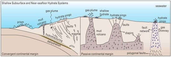
7.1. Classification

In the shallow subsurfaces: Unlike diffusion-dominated deposits confined within permeable reservoirs, such as sand-rich sediments [5] and volcanic ashes [22], marine hydrates in shallow subsurfaces are primarily distributed in sand-poor locales (Table 1) and are controlled by the migration conduits created by tectonic forcings, additional tectonic deformations of sedimentary sequences (such as anticline and fold), and/or self-created networks of faulting and fracturing forced by fluid overpressure. Therefore, they tend to form in veins, fissures, fractures and bedding planes rather than evenly within pore spaces (Table 1). As hydrate growth is continuous, these structures will likely induce larger spaces than diffusion-dominated deposits [3]. Overall, they are different from the pore-fillings in sand reservoirs and the finely disseminated accumulations in the fine-grained and relatively undeformed sediments.
Close to and at the seafloor: We found that surficial hydrate accumulation leads to two kinds of topographic highs: Completely pure hydrate chunks on the pre-existing seafloor and hydrate-bearing mounds (also called hydrate pingoes or outcrops in this paper). The former has been found within carbonate crevices (Figure 10B) or beneath carbonate outcrops (Figure 18). Such habitats behave as isolated pockets of seawater facilitating localized pools of saturated hydrocarbons. Hydrate-bearing mounds, which are much more common than hydrate chunks, refer to the updoming of overlying strata and result from the interplay of the following processes: (1) Pore pressure increase during hydrate nucleation in shallow subsurfaces; (2) decrease in bulk density and expansion of sediments through continued hydrate growth; and (3) buoyancy effects generated from overpressurized gas below the shallow hydrate zone.

7.2. Prerequisites of Formation and Stability of Hydrate Mounds and Pingoes

Hydrate outcrops or chunks are observed close to or at the seafloor level, where the P-T conditions are within the stability field of hydrate formation (Table 1). Nevertheless, hydrates will still dissociate as the inflow of seawater from the seafloor is normally at almost infinite dilution in methane since the chemical potential of methane in the incoming water is much lower than in hydrates. Thus, surrounded by seawater that is under-saturated with respect to enclosed methane, hydrate outcrops will accordingly dissociate and create a dynamic that feeds the cold-seep ecosystems. Moreover, if the temperature of incoming seawater is beyond the limit known as the “hydrate stability zone,” without a doubt, hydrate will dissociate due both to temperature and chemical potential differences.
Therefore, in addition to favorable P–T conditions, one crucial prerequisite for the existence of hydrate deposits at the shallow subsurface and seafloor levels is a sufficient supply of gas-rich fluids through the gas hydrate stability zone (GHSZ). Such deposits are limited to regions of relatively high flux, where gas flow is focused through sulfate-reduction domains.
Furthermore, heavier hydrocarbon concentrations and deeper water depths (Table 1) support the existence of multiple stability fields and resultantly mitigate the inhibition of steady-state hydrate conditions caused by stressors such as fluctuations in water temperature (e.g., GoM, [79]) and salinity. Some biological phenomena (e.g., microbial mats and their excretions) (Figure 4; [78]) and physical processes (e.g., sediment cover and oil coating) (Figure 10A and Figure 23; [78]) may also help stabilize exposed hydrate lobes in methane-undersaturated bottom waters.
However, likely due to technical limitations of in situ time-series observations and deployment difficulties, our research team has found only a few studies that focus on the dynamic processes observed for a hydrate outcropping under in situ conditions at both the Bush Hill location (GC185) [78,79] and Barkley Canyon [132]. Results consistently showed that there were few or no significant changes in the shapes or sizes of sediment/oil-covered hydrate mounds.
As such, due to the different properties of hydrate outcroppings on the seafloor (e.g., with or without oil coating) and inadequate in situ studies, our team decided to exclude descriptions regarding the rates and mechanisms of dynamic processes (dissociation or recrystallization) of seafloor outcroppings in this paper.

7.3. Gas Migration through the GHSZ

Hydrate formation in shallow subsurfaces and near the seafloor requires sufficiently focused migration of free gas or gas-rich fluids through the GHSZ. Why such a large amount of free gas can reach the seafloor is being debated, although the P-T conditions favor solid hydrate formation. To explain the unusual coexistence of free gas and hydrates, researchers have proposed: (1) Rapid gas migration, such that the reaction kinetics limit the rate of hydrate formation [35]; (2) sediment dehydration by hydrates precipitated from gas decoupled from the ascending fluids [5,35] and focused gas into the GHSZ in excess of its proportion in hydrates [117,118]; (3) the high salinity effect of residual waters, enabling the coexistence of hydrates with gas and water [11]; (4) a hydrate/oil coating around bubbles that shields the gas from water [109,149]; (5) coating of the conduit wall with hydrate, which allows the passage of gas through the GHSZ (see Figure 3B in [122]); and (6) localized warm fluid flow, which raises the sediment temperature and allows free gas to ascend through the GHSZ [35,144]. These processes may act in concert or alone to pass gas/fluids through the GHSZ. Noncoincidences of the shallow hydrate deposits with deeper BSRs can be explained by gas conduits that allow gas to bypass the BGHSZ.
The proportion of gas migrating from the deep source zone appears to significantly exceed that used in hydrate formation in situ. On the seafloor, this phenomenon manifests as plumes generated by the surviving gas that was effectively transferred to waters, implying that such marine-gas hydrate deposits may well be temporary carbon reservoirs rather than the main culprit for the greenhouse warming at least in a short period. For example, a recent study in the Barents Sea shows that the timing of the recent methane pulse varies obviously across study sites (based on sulfate profiles), implying such events may respond to episodic ventilation of gas reservoirs at depth instead of the regional perturbations such as bottom water warming [150].
Whether the venting gas flux is continuous or intermittent depends on the pressure condition at and beneath the GHSZ, the buoyant driving force, the strength of the pre-existing fractures, and the dynamics of stress-dependent permeability [117,118,150]. Therefore, accurate quantification may not be reliably determined by observing isolated venting of highly dynamic fluid flux.

7.4. Gas Source and High Geothermal Condition

The occurrence of marine gas hydrates is known to primarily depend on P-T conditions. As such, geothermal conditions play a considerable role in the distribution of hydrate reservoirs. Deep-buried marine hydrates seem most likely to occur in low-temperature geothermal settings, i.e., heat flow values of <70 mW/m2 and a geothermal gradient of <50 °C/km [151]. The lower the geothermal values, the more promising the hydrate reservoirs.
However, we discover in this paper that a low-temperature geothermal condition is not an essential prerequisite for gas hydrates in the shallow subsurface, near or at the seafloor (Table 1). Most shallow hydrate systems have a thermogenic origin (Table 1) or are related to petroleum reservoirs at depth (e.g., Bush Hill and Barkley Canyon). In this way, high-temperature geothermal settings could facilitate thermal degradation of organic matters or oil cracking in relatively deep sediments at temperatures ranging from 230 °C to 240 °C [136]. The resulting abundant active thermogenic hydrocarbons can be effectively pumped by the migration pathways toward the seafloor and form shallow hydrates under suitable P-T conditions. Furthermore, the presence of heavier hydrocarbons expands the hydrate stability zone and assists seafloor hydrate mounds to survive some stresses, e.g., (1) the positive salt and heat-flow anomalies around the diapirs (e.g., Bush Hill and offshore Angola); (2) a temporary rise in bottom water temperatures caused by warm water intrusion (e.g., Bush Hill); and (3) a decrease in hydrostatic pressure due to the relatively shallow water depths (e.g., the Barents Sea).
In addition to the foregoing, hydrostatic pressure created by the water column is greater in deeper water, which can help relieve the stress of high heat flow on the GHSZ (Table 1; e.g., Ulleung Basin). Such higher hydrostatic pressure may also contribute to the stable existence of surficial methane hydrates (i.e., structure I hydrate) of microbial origin (Table 1; Ulleung Basin; BRD; and the Bullseye cold vent).
The hydrate-bearing shallow sediments are immature for in situ hydrocarbon generation, and producing focused fluid flows is difficult. Some shallow hydrate deposits with microbial isotopic signatures may result from the geo distillation effect of the slow upwards migration of deep thermogenic gases, such as the Nyegga area in the Norwegian Sea. After all, the low TOC (0.5 wt.%) in the upper 400 m indicates little potential for methanogenesis (see Section 1.4; [62]). Otherwise, clay dehydration at greater depths caused by high heat flow can supply profuse allochthonous microbial gas-rich fluids (e.g., Ulleung Basin).

7.5. Ecological and Economic Effects

Vent-related near-seafloor hydrate deposits are discrete, isolated oases colonized by one of the richest submarine chemosynthetic systems, including bacterial mats, tubeworms, and other macro-species relying on the byproducts of AOM. In such oases, local primary productivity is enhanced. Near-seafloor hydrates, along with seafloor vent structures, are temporary carbon-storage cupboards with excess-pressure release “valves” that either guard against or participate in geological hazards such as slope failures [54]. Moreover, near-seafloor hydrates may detach and float upward when the gas pressure and hydrate buoyancy exceed the load of superjacent deposits (as observed on the Southern Hydrate Ridge and Batumi seep area). This mechanism can more effectively transfer methane to the sea–atmosphere interface than ascending gas plumes [109,152].
These shallow, easily accessible, and highly saturated surficial hydrate resources are likely to be more economically viable than disseminated deposits. However, owing to their high spatial variability, their total size and producibility remain largely unknown (see “resource pyramid” in [3]). Resources in individual hydrate mounds have been estimated for offshore Angola [92] but rarely reported elsewhere. Nevertheless, several countries have begun exploring techniques for production tests of near-seafloor hydrate deposits [4]. For example, Japan is collaborating with MHWirth on an excavating tool with a disc that breaks surficial hydrates into fragments and upwardly extracts them through a tubing system [153]. China’s researchers have invented a climbing excavator that removes the cracked hydrate particles and expels stones to backfill the pit.
It should be noted that production infrastructures can transfer heat and other stressors to shallow hydrates. Therefore, shallow hydrates become susceptible to the resulting fluctuating P-T conditions or salinity and may further trigger slope failure or seafloor subsidence. Moreover, production may exert further impacts on seep-related chemosynthetic communities.

8. Conclusions

This paper provided an integrated description of marine gas hydrate systems in the shallow subsurfaces, near and at the seafloor. In a figurative sense, such gas hydrate accumulation could be compared with an active organic system, with migrating fluids and conduits representing the “blood” and “bones,” respectively. The “heart” is a restricted area, i.e., the pathway root, that can gather considerable gas–fluids, thereby forming excess pore pressure as one essential driving force for focused fluid flow in impermeable sediments, i.e., the organic system. Their locations determine the actual locations of the gas hydrate deposits and contribute to the GHSZ’s heterogeneous allocation. Therefore, understanding the gas sources, migration, and accumulation systems is crucial for determining the distribution of such gas hydrate reservoirs, performing hydrate resource assessment, and developing theoretical site selection strategies. We hope that this paper will be useful in future marine gas hydrate projects for site selection, drilling, and coring for similar occurrences of marine gas hydrate reservoirs.

Author Contributions

L.L. wrote the paper; F.C. and N.W. supervised and provided critical reviews. All authors contributed to information collection. All authors have read and agreed to the published version of the manuscript.

Funding

The authors gratefully acknowledge the financial support from China Ocean Mineral Resource R&D Association (COMRA) “Thirteen-Five” Program (Grant Nos. DY135-N1-1, DY135-N2-1, and DY135-N1-1-01).

Institutional Review Board Statement

Not applicable.

Informed Consent Statement

Not applicable.

Data Availability Statement

Data not available.

Acknowledgments

We would like to thank Moe Kyaw (JAMSTEC) for his encouragement. We would like to thank the reviewers for their comments and constructive suggestions and Anna Korzeniewska for editing the article.

Conflicts of Interest

The authors declare no conflict of interest.

References

  1. Boswell, R.; Collett, T.S.; Frye, M.; Shedd, B.; Shelander, D. Subsurface gas hydrates in the northern Gulf of Mexico. Mar. Pet. Geol. 2012, 34, 4–30. [Google Scholar] [CrossRef]
  2. Wu, N.Y.; Su, M.; Xu, H.N.; Liu, C.L.; Hu, G.w.; Qiao, S.H.; Yang, R.; Huang, L.; Liu, J.; Li, C.F. Gas Hydrate Migration and Accumulation System: Theory, Method and Practice; Anhui Science and Technology Press: Anhui, China, 2020. (In Chinese) [Google Scholar]
  3. Boswell, R.; Collett, T. The Gas Hydrates Resource Pyramid. Fire in the Ice. In Methane Hydrate Newsletter; US Department of Energy, Office of Fossil Energy, National Energy Technology Laboratory: Pittsburgh, PA, USA, 2006; pp. 1–16. [Google Scholar]
  4. Liu, L.P.; Sun, Z.L.; Zhang, L.; Wu, N.Y.; Qin, Y.C.; Jiang, Z.Z.; Geng, W.; Cao, H.; Zhang, X.L.; Zhai, B.; et al. Progress in Global Gas Hydrate Development and Production as a New Energy Resource. Bull. Geol. Soc. China 2019, 93, 731–755. [Google Scholar] [CrossRef]
  5. Matsumoto, R.; Ryu, B.J.; Lee, S.R.; Lin, S.; Wu, S.G.; Sain, K.; Pecher, I.; Riedel, M. Occurrence and exploration of gas hydrate in the marginal seas and continental margin of the Asia and Oceania region. Mar. Pet. Geol. 2011, 28, 1751–1767. [Google Scholar] [CrossRef]
  6. Horozal, S.; Lee, G.H.; Yi, B.Y.; Dong, G.Y.; Park, K.P.; Lee, H.Y.; Kim, W.; Han, J.K.; Lee, K. Seismic indicators of gas hydrate and associated gas in the Ulleung Basin, East Sea (Japan Sea) and implications of heat flows derived from depths of the bottom-simulating reflector. Mar. Geol. 2009, 258, 126–138. [Google Scholar] [CrossRef]
  7. Kang, N.K.; Yoo, D.G.; Bo, Y.Y.; Ryu, B.J.; Lee, S.R. Seismic chimneys associated with gas hydrates in the Ulleung Basin, East Sea of Korea. In Proceedings of the 7th Internal Conference on Gas Hydrate, Scotland, UK, 17–21 July 2011. [Google Scholar]
  8. Yoo, D.G.; Kang, N.K.; Yi, B.Y.; Kim, G.Y.; Ryu, B.J.; Lee, K.; Lee, G.H.; Riedel, M. Occurrence and seismic characteristics of gas hydrate in the Ulleung Basin, East Sea. Mar. Pet. Geol. 2013, 47, 236–247. [Google Scholar] [CrossRef]
  9. Matsumoto, R.; Tanahashi, M.; Kakuwa, Y.; Snyder, G.; Ohkawa, S.; Tomaru, H.; Morita, S. Recovery of thick deposits of massive gas hydrates from gas chimney. Fire Ice 2017, 17, 1–6. [Google Scholar]
  10. Freire, A.F.M.; Matsumoto, R.; Akiba, F. Geochemical analysis as a complementary tool to estimate the uplift of sediments caused by shallow gas hydrates in mounds at the seafloor of Joetsu Basin, eastern margin of the Japan Sea. J. Geol. Res. 2012, 2012, 839840. [Google Scholar] [CrossRef]
  11. Matsumoto, R.; Okuda, Y.; Hiruta, A.; Tomaru, H.; Takeuchi, E.; Sanno, R.; Suzuki, M.; Tsuchinaga, K.; Ishida, Y.; Ishizaki, O.; et al. Formation and collapse of gas hydrate deposits in high methane flux area of the Joetsu basin, eastern margin of Japan sea. J. Geogr. 2009, 118, 43–71, (In Japanese with abstract in English). [Google Scholar] [CrossRef]
  12. Hiruta, A.; Snyder, G.T.; Tomaru, H.; Matsumotoa, R. Geochemical constraints for the formation and dissociation of gas hydrate in an area of high methane flux, eastern margin of the Japan Sea. Earth Planet. Sci. Lett. 2009, 279, 326–339. [Google Scholar] [CrossRef]
  13. Snyder, G.T.; Sano, Y.; Takahata, N.; Matsumoto, R.; Kakizaki, Y.; Tomaru, H. Magmatic fluids play a role in the development of active gas chimneys and massive gas hydrates in the Japan Sea. Chem. Geol. 2020, 535, 119462. [Google Scholar] [CrossRef]
  14. Freire, A.M.F.; Matsumoto, R.; Santos, L.A. Structural-stratigraphic control on the Umitaka Spur gas hydrates of Joetsu Basin in the eastern margin of Japan Sea. Mar. Pet. Geol. 2011, 28, 1967–1978. [Google Scholar] [CrossRef]
  15. Nguyen, B.T.T.; Kido, M.; Okawa, N.; Fu, H.; Kakizaki, S.; Imahori, S. Compaction of smectite-rich mudstone and its influence on pore pressure in the deepwater Joetsu Basin, Sea of Japan. Mar. Pet. Geol. 2016, 78, 848–869. [Google Scholar] [CrossRef]
  16. Matsumoto, R.; Kakuwa, Y.; Snyder, G.T.; Tanahashi, M.; Yanagimoto, Y.; Morita, S. Verification and recovery of thick deposits of massive gas hydrate from chimney structures, eastern margin of Japan Sea. In Proceedings of the AGU Fall Meeting, San Francisco, CA, USA, 11–15 December 2016. [Google Scholar]
  17. Snyder, G.T.; Hiruta, A.; Matsumoto, R.; Dickens, G.R.; Tomaru, H.; Takeuchi, R.; Komatsubara, J.; Ishida, Y.; Yu, H. Pore water profiles and authigenic mineralization in shallow marine sediments above the methane-charged system on Umitaka Spur, Japan Sea. Deep. Sea Res. Part II Top. Stud. Oceanogr. 2007, 54, 1216–1239. [Google Scholar] [CrossRef]
  18. Tomaru, H.; Lu, Z.; Snyder, G.T.; Fehn, U.; Hiruta, A.; Matsumoto, R. Origin and age of pore waters in an actively venting gas hydrate field near Sado Island, Japan Sea: Interpretation of halogen and 129I distributions. Chem. Geol. 2007, 236, 350–366. [Google Scholar] [CrossRef]
  19. Shakirov, R.B.; Syrbu, N.S.; Obzhirov, A.I. Distribution of helium and hydrogen in sediments and water on the Sakhalin slope. Lithol. Miner. Resour. 2016, 51, 61–73. [Google Scholar] [CrossRef]
  20. Riedel, M.; Bahk, J.J.; Scholz, N.A.; Ryu, B.J.; Yoo, D.G.; Kim, W.; Kim, G.Y. Mass-transport deposits and gas hydrate occurrences in the Ulleung Basin, East Sea-Part 2: Gas hydrate content and fracture-induced anisotropy. Mar. Pet. Geol. 2012, 35, 75–90. [Google Scholar] [CrossRef]
  21. Ryu, B.J.; Riedel, M.; Kim, J.H.; Hyndman, R.D.; Lee, Y.J.; Chung, B.H.; Kim, I.S. Gas hydrates in the western deep-water Ulleung Basin, East Sea of Korea. Mar. Pet. Geol. 2009, 26, 1483–1498. [Google Scholar] [CrossRef]
  22. Ryu, B.J.; Collett, T.S.; Riedel, M.; Kim, G.T.; Chun, J.H.; Bahk, J.J.; Lee, J.Y.; Kim, J.H.; Yoo, D.G. Scientific results of the Second Gas Hydrate Drilling Expedition in the Ulleung Basin (UBGH2). Mar. Pet. Geol. 2013, 47, 1–20. [Google Scholar] [CrossRef]
  23. Lee, G.H.; Suk, B.C. Latest Neogene-Quaternary seismic stratigraphy of the Ulleung Basin, East Sea (Sea of Japan). Mar. Geol. 1998, 146, 205–224. [Google Scholar] [CrossRef]
  24. Riedel, M.; Collett, T.S.; Kim, H.S.; Bahk, J.J.; Kim, J.H.; Ryu, B.J.; Kim, G.Y. Large-scale depositional characteristics of the Ulleung Basin and its impact on electrical resistivity and Archie-parameters for gas hydrate saturation estimates. Mar. Pet. Geol. 2013, 47, 222–235. [Google Scholar] [CrossRef]
  25. Scholz, N.A.; Riedel, M.; Bahk, J.J.; Yoo, D.G.; Ryu, B.J. Mass transport deposits and gas hydrate occurrences in the Ulleung Basin, East Sea-Part 1: Mapping sedimentation patterns using seismic coherency. Mar. Pet. Geol. 2012, 35, 91–104. [Google Scholar] [CrossRef]
  26. Ryu, B.J.; Riedel, M. Gas hydrates in the Ulleung Basin, East Sea of Korea. Terr. Atmos. Ocean. Sci. 2017, 28, 943–963. [Google Scholar] [CrossRef]
  27. Bahk, J.J.; Kim, D.H.; Chun, J.H.; Son, B.K.; Kim, J.H.; Ryu, B.J.; Torres, M.E.; Riedel, M.; Schultheiss, P. Gas hydrate occurrences and their relation to host sediment properties: Results from Second Ulleung Basin Gas Hydrate Drilling Expedition, East Sea. Mar. Pet. Geol. 2013, 47, 21–29. [Google Scholar] [CrossRef]
  28. Bahk, J.J.; Kim, J.H.; Kong, G.S.; Park, Y.; Lee, H.; Park, Y.J.; Park, K.P. Occurrence of near-seafloor gas hydrates and associated cold vents in the Ulleung Basin, East Sea. Geosci. J. 2010, 13, 371–385. [Google Scholar] [CrossRef]
  29. Chun, J.H.; Ryu, B.J.; Son, B.K.; Kim, J.H.; Lee, J.Y.; Bahk, J.J.; Kim, H.J.; Woo, K.S.; Nehza, O. Sediment mounds and other sedimentary features related to hydrate occurrences in a columnar seismic blanking zone of the Ulleung Basin, East Sea, Korea. Mar. Pet. Geol. 2011, 28, 1787–1800. [Google Scholar] [CrossRef]
  30. Torres, M.E.; Kim, J.H.; Choi, J.Y.; Ryu, B.J.; Bahk, J.J.; Riedel, M.; Collett, T.S.; Hong, W.L.; Kastner, M. Occurrence of high salinity fluids asociated with massive near-seafloor gas hydrate deposits. In Proceedings of the 7th International Conference on Gas Hydrates (ICGH 2011), Edinburgh, Scotland, UK, 17–21 July 2011. [Google Scholar]
  31. Park, K.P.; Bahk, J.J.; Kwon, Y.; Kim, G.; Riedel, M.; Holland, M.; Schultheiss, P.J.; Rose, K. Korean National Program Expedition Confirms Rich Gas Hydrate Deposit in the Ulleung Basin, East Sea; Spring 2008 Methane Hydrate Newsletter; U.S. Department of Energy, Office of Fossil Energy, National Energy Technology Laboratory: Pittsburgh, DC, USA, 2008; pp. 6–9.
  32. Hornbach, M.J.; Ruppel, C.; Saffer, D.M.; Dover, C.L.V.; Holbrook, W.S. Coupled geophysical constraints on heat flow and fluid flux at a salt diapir. Geophys. Res. Lett. 2005, 32, L24617. [Google Scholar] [CrossRef]
  33. Choi, J.; Kim, J.H.; Torres, M.E.; Hong, W.L.; Lee, J.W.; Yi, B.Y.; Bahk, J.J.; Lee, K.E. Gas origin and migration in the Ulleung Basin, East Sea: Results from the Second Ulleung Basin Gas Hydrate Drilling Expedition (UBGH2). Mar. Pet. Geol. 2013, 47, 113–124. [Google Scholar] [CrossRef]
  34. Kim, J.H.; Torres, M.E.; Choi, J.; Bahk, J.J.; Park, M.H.; Hong, W.L. Inferences on gas transport based on molecular and isotopic signatures of gases at acoustic chimneys and background sites in the Ulleung Basin. Org. Geochem. 2012, 43, 26–38. [Google Scholar] [CrossRef]
  35. Haacke, R.R.; Hyndman, R.D.; Park, K.P.; Yoo, D.; Stoian, I.; Schmidt, U. Migration and venting of deep gases into the ocean through hydrate-choked chimneys offshore Korea. Geology 2009, 37, 531–534. [Google Scholar] [CrossRef]
  36. Kim, J.H.; Torres, M.E.; Hong, W.L.; Choi, J.; Riedel, M.; Bahk, J.J.; Kim, S.H. Pore fluid chemistry from the Second Gas Hydrate Drilling Expedition in the Ulleung Basin (UBGH2): Source, mechanisms and consequences of fluid freshening in the central part of the Ulleung Basin, East Sea. Mar. Pet. Geol. 2013, 47, 99–112. [Google Scholar] [CrossRef]
  37. Mora, G. Isotope-tracking of pore water freshening in the fore-arc basin of the Japan Trench. Mar. Geol. 2005, 219, 71–79. [Google Scholar] [CrossRef]
  38. Waage, M.; Portnov, A.; Serov, P.; Bünz, S.; Waghorn, K.A.; Vadakkepuliyambatta, S.; Mienert, J.; Andreassen, K. Geological Controls on Fluid Flow and Gas Hydrate Pingo Development on the Barents Sea Margin. Geochem. Geophys. Geosystems 2019, 20, 630–650. [Google Scholar] [CrossRef]
  39. Waage, M.; Serov, P.; Andreassen, K.; Waghorn, K.A.; Bünz, S. Geological controls of giant crater development on the Arctic seafloor. Sci. Rep. 2020, 10, 8450. [Google Scholar] [CrossRef]
  40. Serov, P.; Vadakkepuliyambattaa, S.; Mienert, J.; Patton, H.; Portnov, A.; Silyakova, A.; Panieri, G.; Carroll, M.L.; Carroll, J.; Andreassen, K. Postglacial response of Arctic Ocean gas hydrates to climatic amelioration. Proc. Natl. Acad. Sci. USA 2017, 114, 6215–6220. [Google Scholar] [CrossRef]
  41. Andreassen, K.; Hubbard, A.; Winsborrow, M.; Patton, H.; Vadakkepuliyambatta, S.; Plaza-Faverola, A.; Gudlaugsson, E.; Serov, P.; Deryabin, A.; Mattingsdal, R.; et al. Massive blow-out craters formed by hydrate-controlled methane expulsion from the Arctic seafloor. Science 2017, 356, 948–953. [Google Scholar] [CrossRef]
  42. Nixon, F.C.; Chand, S.; Thorsnes, T.; Bjarnadóttir, L.R. A modified gas hydrate-geomorphological model for a new discovery of enigmatic craters and seabed mounds in the Central Barents Sea, Norway. Geo-Mar. Lett. 2019, 39, 191–203. [Google Scholar] [CrossRef]
  43. Rasmussen, T.L.; Thomsen, E.; ŚLubowska, M.A.; Jessen, S.; Solheim, A.; Koç, N. Paleoceanographic evolution of the SW Svalbard margin (76° N) since 20,000 14C yr BP. Quat. Res. 2007, 67, 100–114. [Google Scholar] [CrossRef]
  44. Anell, I.; Faleide, J.; Braathen, A. Regional tectono-sedimentary development of the highs and basins of the northwestern Barents Shelf. Nor. Geol. Tidsskr. 2016, 96, 27–41. [Google Scholar] [CrossRef]
  45. Vorren, T.O.; Richardsen, G.; Knutsen, S.M.; Henriksen, E. Cenozoic erosion and sedimentation in the western Barents Sea. Mar. Pet. Geol. 1991, 8, 317–340. [Google Scholar] [CrossRef]
  46. Paull, C.K.; Ussler, W.; Dallimore, S.R.; Blasco, S.M.; Lorenson, T.D.; Melling, H.; Medioli, B.E.; Nixon, F.M.; McLaughlin, F.A. Origin of pingo-like features on the Beaufort Sea shelf and their possible relationship to decomposing methane gas hydrates. Geophys. Res. Lett. 2007, 34, L01603. [Google Scholar] [CrossRef]
  47. Serov, P.; Portnov, A.; Mienert, J.; Semenov, P.; Ilatovskaya, P. Methane release from pingo-like features across the South Kara Sea shelf, an area of thawing offshore permafrost. J. Geophys. Res. Earth Surf. 2015, 120, 1515–1529. [Google Scholar] [CrossRef] [Green Version]
  48. Bünz, S.; Mienert, J.; Bryn, P.; Berg, K. Fluid flow impact on slope failure from 3D seismic data: A case study in the Storegga Slide. Basin Res. 2005, 17, 109–122. [Google Scholar] [CrossRef]
  49. Hustoft, S.; Mienert, J.; Bünz, S.; Nouzé, H. High-resolution 3D-seismic data indicate focussed fluid migration pathways above polygonal fault systems of the mid-Norwegian margin. Mar. Geol. 2007, 245, 89–106. [Google Scholar] [CrossRef]
  50. Plaza-Faverola, A.; Bünz, S.; Mienert, J. Fluid distributions inferred from P-wave velocity and reflection seismic amplitude anomalies beneath the Nyegga pockmark field of the mid-Norwegian margin. Mar. Ans Pet. Geol. 2010, 27, 46–60. [Google Scholar] [CrossRef]
  51. Plaza-Faverola, A.; Westbrook, G.K.; Ker, S.; Exley, R.K.; Gailler, A.; Minshull, T.A.; Broto, K. Evidence from three-dimensional seismic tomography for a substantial accumulation of gas hydrate in a fluid-escape chimney in the Nyegga pockmark field, offshore Norway. J. Geophys. Res. Solid Earth 2010, 115, B08104. [Google Scholar] [CrossRef]
  52. Hovland, M.; Svensen, H.; Forsberg, C.F.; Johansen, H.; Fichler, C.; Fosså, J.H.; Jonsson, R.; Rueslåtten, H. Complex pockmarks with carbonate-ridges off mid-Norway: Products of sediment degassing. Mar. Geol. 2005, 218, 191–206. [Google Scholar] [CrossRef]
  53. Mazzini, A.; Aloisi, G.; Akhmanov, G.G.; Parnell, J.; Cronin, B.T.; Murphy, P. Integrated petrographic and geochemical record of hydrocarbon seepage on the Vøring Plateau. J. Geol. Soc. 2005, 162, 815–827. [Google Scholar] [CrossRef]
  54. Hovland, S.; Svensen, H. Submarine pingoes: Indicators of shallow gas hydrates in a pockmark at Nyegga, Norwegian Sea. Mar. Geol. 2006, 228, 15–23. [Google Scholar] [CrossRef]
  55. Westbrook, G.K.; Exley, R.; Minshull, T.A.; Nouzé, H.; Gailler, A.; Jose, T.; Ker, S.; Plaza, A. High-resolution 3D seismic investigations of hydrate-bearing fluid escape chimneys in the Nyegga region of the Vøring Plateau, Norway. In Proceedings of the 6th International Conference on Gas Hydrates (ICGH 2008), Vancouver, BC, Canada, 6–10 July 2008. [Google Scholar] [CrossRef]
  56. Chen, Y.F.; Ussler, W., III; Haflidason, H.; Rise, L.; Hovland, M.; Hjelstuen, B.O. Sources of methane inferred from pore-water δ13C of dissolved inorganic carbon in Pockmark G11, offshore Mid-Norway. Chem. Geol. 2010, 275, 127–138. [Google Scholar] [CrossRef]
  57. Ivanov, M.; Mazzini, A.; Blinova, V.; Kozlova, E.; Laberg, J.S.; Matveeva, T.; Taviani, M.; Kaskov, N. Seep mounds on the Southern Vring Plateau (offshore Norway). Mar. Pet. Geol. 2010, 27, 1235–1261. [Google Scholar] [CrossRef]
  58. Cathles, L.M.; Zheng, S.; Chen, D.F. The physics of gas chimney and pockmark formation, with implications for assessment of seafloor hazards and gas sequestration. Mar. Pet. Geol. 2010, 27, 82–91. [Google Scholar] [CrossRef]
  59. Hovland, M. On the self-sealing nature of marine seeps. Cont. Shelf Res. 2002, 22, 2287–2394. [Google Scholar] [CrossRef]
  60. Hovland, M.; Heggland, R.; Vries, M.; Tjelta, T.I. Unit-pockmarks and their potential significance for predicting fluid flow. Mar. Pet. Geol. 2010, 27, 1190–1199. [Google Scholar] [CrossRef]
  61. Senger, K.; Bünz, S.; Mienert, J. First-Order Estimation of In-Place Gas Resources at the Nyegga Gas Hydrate Prospect, Norwegian Sea. Energies 2010, 3, 2001–2026. [Google Scholar] [CrossRef]
  62. Vaular, E.N.; Barth, T.; Haflidason, H. The geochemical characteristics of the hydrate-bound gases from the Nyegga pockmark field, Norwegian Sea. Org. Geochem. 2010, 41, 437–444. [Google Scholar] [CrossRef]
  63. Fuex, A.N. The use of stable carbon isotopes in hydrocarbon exploration. J. Geochem. Explor. 1977, 7, 155–188. [Google Scholar] [CrossRef]
  64. Brekke, T.; Lønne, Ø.; Ohm, S.E. Light hydrocarbon gases in shallow sediments in the northern North Sea. Mar. Geol. 1997, 137, 81–108. [Google Scholar] [CrossRef]
  65. Gay, A.; Lopez, M.; Ondreas, H.; Charlou, J.L.; Sermondadaz, G.; Cochonat, P. Seafloor facies related to upward methane flux within a Giant Pockmark of the Lower Congo Basin. Mar. Geol. 2006, 226, 81–95. [Google Scholar] [CrossRef]
  66. Gay, A.; Lopez, M.; Berndt, C.; Séranne, M. Geological controls on focused fluid flow associated with seafloor seeps in the Lower Congo Basin. Mar. Geol. 2007, 244, 68–92. [Google Scholar] [CrossRef]
  67. Brooks, J.M.; Cox, H.B.; Bryant, W.R.; Kennicutt II, M.C.; Mann, R.G.; McDonald, T.G. Association of gas hydrates and oil seepage in the Gulf of Mexico. Org. Geochem. 1986, 10, 221–234. [Google Scholar] [CrossRef]
  68. Collett, T.S.; Riedel, M.; Cochran, J.; Boswell, R.; Kumar, P.; Sathe, A. Results of the Indian National Gas Hydrate Program Expedition 01 Initial Reports; Report; Director General of Hydrocarbons, Ministry of Petroleum and Natural Gas: New Delhi, India, 2008.
  69. Sain, K.; Gupta, H. Gas hydrates in India: Potential and development. Gondwana Res. 2012, 22, 645–657. [Google Scholar] [CrossRef]
  70. Shukla, K.M.; Collett, T.S.; Kumar, P.; Yadav, U.S.; Boswell, R.; Frye, M.; Riedel, M.; Kaur, I.; Vishwanath, K. National Gas Hydrate Program expedition 02: Identification of gas hydrate prospects in the Krishna-Godavari Basin, offshore India. Mar. Pet. Geol. 2019, 108, 167–184. [Google Scholar] [CrossRef]
  71. Dewangan, P.; Sriram, G.; Ramprasad, T.; Ramana, M.V.; Jaiswal, P. Fault system and thermal regime in the vicinity of site NGHP-01-10, Krishna-Godavari basin, Bay of Bengal. Mar. Pet. Geol. 2011, 28, 1899–1914. [Google Scholar] [CrossRef]
  72. Dewangan, P.; Ramprasad, T.; Ramana, M.V.; Mazumdar, A.; Desa, M.; Badesab, F.K. Seabed morphology and gas venting features in the continental slope region of Krishna-Godavari basin, Bay of Bengal: Implications in gas-hydrate exploration. Mar. Pet. Geol. 2010, 27, 1628–1641. [Google Scholar] [CrossRef]
  73. Rao, G.N.; Mani, K.S. A study on generation of abnormal pressures in KrishnaeGodavari basin. Indian J. Pet. Geol. 1993, 2, 20–30. [Google Scholar]
  74. Riedel, M.; Collett, T.S.; Kumar, P.; Sathe, A.V.; Cook, A. Seismic imaging of a fractured gas hydrate system in the Krishna-Godavari Basin offshore India. Mar. Pet. Geol. 2010, 27, 1476–1493. [Google Scholar] [CrossRef]
  75. NIO. Geo-Scientific Investigations of Shallow Sediment in KG Offshore, East Coast; National Institute of Oceanography: Dona Paula, India; NIO/TR-13/2005; p. 103.
  76. Francisca, F.; Yun, T.S.; Ruppel, C.; Santamarin, J.C. Geophysical and geotechnical properties of near-seafloor sediments in the northern Gulf of Mexico gas hydrate province. Earth Planet. Sci. Lett. 2005, 237, 924–939. [Google Scholar] [CrossRef]
  77. Sassen, R.; Losh, S.L.; Cathles, L.M.; Roberts, H.H.; Whelan, J.K.; Milkov, A.V.; Sweet, S.T.; DeFreitas, D.A. Massive vein-filling gas hydrate: Relation to ongoing gas migration from the deep subsurface in the Gulf of Mexico. Mar. Pet. Geol. 2001, 18, 551–560. [Google Scholar] [CrossRef]
  78. Vardaro, M.F.; Macdonald, I.R.; Bender, L.C.; Guinasso, N. Dynamic processes observed at a gas hydrate outcropping on the continental slope of the Gulf of Mexico. Geo-Mar. Lett. 2006, 26, 6–15. [Google Scholar] [CrossRef]
  79. Solomon, E.A.; Kastner, M.; Jannasch, H.; Robertson, G.; Weinstein, Y.S. Dynamic fluid flow and chemical fluxes associated with a seafloor gas hydrate deposit on the northern Gulf of Mexico slope. Earth Planet. Sci. Lett. 2008, 270, 95–105. [Google Scholar] [CrossRef]
  80. Salvador, A. Late Triassic-Jurassic paleogeography and origin of Gulf of Mexico basin. Am. Assoc. Pet. Geol. Bull. 1987, 71, 419–451. [Google Scholar] [CrossRef]
  81. McGookey, D.P. Gulf coast Cenozoic sediments and structure; An excellent example of extra-continental sedimentation. Trans. Gulf Coast Assoc. Geol. Soc. 1975, 25, 104–120. [Google Scholar] [CrossRef]
  82. Bryant, W.R.; Bryant, J.R.; Feeley, M.H.; Simmons, G.R. Physiographic and bathymetric characteristics of the continental slope, northwest Gulf of Mexico. Geo-Mar. Lett. 1990, 10, 182–199. [Google Scholar] [CrossRef]
  83. Sager, W.W.; Macdonald, I.R.; Hou, R. Geophysical signatures of mud mounds at hydrocarbon seeps on the Louisiana continental slope, northern Gulf of Mexico. Mar. Geol. 2003, 198, 97–132. [Google Scholar] [CrossRef]
  84. Cook, D.; D’Onfro, P. Jolliet field thrust structure and stratigraphy Green canyon block 184, offshore Louisiana. Trans. Gulf Coast Assoc. Geol. Soc. 1991, 41, 100–121. [Google Scholar] [CrossRef]
  85. MacDonald, I.R.; Guinasso, N.L.; Sassen, R.; Brooks, J.M.; Lee, L.; Scott, K.T. Gas hydrate that breaches the sea floor on the continental slope of the Gulf of Mexico. Geology 1994, 22, 699–702. [Google Scholar] [CrossRef]
  86. Chen, D.F.; Cathles, L.M., III. A kinetic model for the pattern and amounts of hydrate precipitated from a gas steam: Application to the Bush Hill vent site, Green Canyon Block 185, Gulf of Mexico. J. Geophys. Res. Solid Earth 2003, 108, 2058. [Google Scholar] [CrossRef]
  87. MacDonald, I.R.; Bender, L.C.; Vardaro, M.; Bernard, B.; Brooks, J.M. Thermal and visual time-series at a seafloor gas hydrate deposit on the Gulf of Mexico slope. Earth Planet. Sci. Lett. 2005, 233, 45–59. [Google Scholar] [CrossRef]
  88. Sassen, R.; Joye, S.; Sweet, S.T.; Defreitas, D.A.; Milkov, A.V.; Macdonald, I.R. Thermogenic gas hydrates and hydrocarbon gases in complex chemosynthetic communities, Gulf of Mexico continental slope. Org. Geochem. 1999, 30, 485–497. [Google Scholar] [CrossRef]
  89. Simonetti, A.; Knapp, J.H.; Sleeper, K.; Lutken, C.B.; Macelloni, L.; Knapp, C.C. Spatial distribution of gas hydrates from high-resolution seismic and core data, Woolsey Mound, Northern Gulf of Mexico. Mar. Pet. Geol. 2013, 44, 21–33. [Google Scholar] [CrossRef]
  90. Macelloni, L.; Lutken, C.B.; Garg, S.; Simonetti, A.; D’Emidio, M.; Wilson, R.M.; Sleeper, K.; Lapham, L.L.; Lewis, T.; Pizzi, M.; et al. Heat-flow regimes and the hydrate stability zone of a transient, thermogenic, fault-controlled hydrate system (Woolsey Mound northern Gulf of Mexico). Mar. Pet. Geol. 2015, 59, 491–504. [Google Scholar] [CrossRef] [Green Version]
  91. Macelloni, L.; Simonetti, A.; Knapp, J.H.; Knapp, C.C.; Lapham, L.L. Multiple resolution seismic imaging of a shallow hydrocarbon plumbing system, Woolsey Mound, Northern Gulf of Mexico. Mar. Pet. Geol. 2012, 38, 128–142. [Google Scholar] [CrossRef]
  92. Serié, C.; Huuse, M.; Schodt, N.H. Gas hydrate pingoes: Deep seafloor evidence of focused fluid flow on continental margins. Geology 2012, 40, 207–210. [Google Scholar] [CrossRef]
  93. Andresen, K.J.; Huuse, M.; Schødt, N.H.; Clausen, L.F.; Seidler, L. Hydrocarbon plumbing systems of salt minibasins offshore Angola revealed by three-dimensional seismic analysis. AAPG Bull. 2011, 95, 1039–1065. [Google Scholar] [CrossRef]
  94. Brownfield, M.E.; Charpentier, R.R. Geology and total petroleum systems of the WestCentral Coastal Province (7203), West Africa. U.S. Geol. Surv. Bull. 2006, 2207, 52. [Google Scholar] [CrossRef]
  95. Singh, S.C.; Minshull, T.A.; Spence, G.D. Velocity structure of a gas hydrate reflector. Science 1993, 260, 204–207. [Google Scholar] [CrossRef]
  96. Lucazeau, F.; Brigaud, F.; Bouroullec, J.L. High-resolution heat flow density in the lower Congo basin. Geochem. Geophys. Geosystems 2004, 5. [Google Scholar] [CrossRef]
  97. Serié, C.; Huuse, M.; Schdt, N. Salt Tectonic Controls on Fluid Flow, Gas Hydrate Occurrence and Surface Heat, Kwanza Basin, Offshore Angola. In Proceedings of the AAPG Annual Convention and Exhibition, Houston, TX, USA, 10–13 April 2011. [Google Scholar]
  98. Dillon, W.P.; Popenoe, P.; Grow, J.A.; Klitgord, K.D.; Swift, B.A.; Paull, C.K.; Cashman, K.V. Growth faulting and salt diapirism; their relationship and control in the Carolina Trough, Eastern North America. In Studies in Continental Margin Geology; Watkins, J.S., Drake, C.L., Eds.; AAPG Memoir 34; Datapages, Inc.: Tulsa, OK, USA, 1982; pp. 21–46. [Google Scholar] [CrossRef]
  99. Paull, C.K.; Matsumoto, R.; Wallace, P.J. Gas hydrate sampling on the Blake Ridge and Carolina Rise. In Ocean Drilling Program; Leg 164 Preliminary Report; International Ocean Discovery Program: College Station, TX, USA, 1996. [Google Scholar]
  100. Paull, C.K.; Ussler, W.; Borowski, W.S.; Spiess, F.N. Methane-rich plumes on the Carolina continental rise: Associations with gas hydrates. Geology 1995, 23, 89–92. [Google Scholar] [CrossRef]
  101. Taylor, M.H.; Dillon, W.P.; Pecher, I.A. Trapping and migration of methane associated with the gas hydrate stability zone at the Blake Ridge Diapir: New insights from seismic data. Mar. Geol. 2000, 164, 79–89. [Google Scholar] [CrossRef]
  102. Hornbach, M.J.; Ruppel, C.; Dover, C.V. Three-dimensional structure of fluid conduits sustaining an active deep marine cold seep. Geophys. Res. Lett. 2007, 34, 508–512. [Google Scholar] [CrossRef]
  103. Borowski, W.S. A review of methane and gas hydrates in the dynamic, stratified system of the Blake Ridge region, offshore southeastern North America. Chem. Geol. 2004, 205, 311–346. [Google Scholar] [CrossRef]
  104. Matsumoto, R.; Uchida, T.; Waseda, A.; Takeya, S.; Hirano, T.; Yamada, K.; Maeda, Y.; Okui, T. Occurrence, structure, and composition of natural gas hydrate recovered from the Blake Ridge, northwest Atlantic. Proc. Ocean. Drill. Program Sci. Results 2000, 164, 13–28. [Google Scholar] [CrossRef]
  105. Van Dover, C.L.; Aharon, P.; Bernhard, J.M.; Caylor, E.; Doerries, M.; Flickinger, W.; Gilhooly, W.; Goffredi, S.K.; Knick, K.E.; Macko, S.A.; et al. Blake Ridge methane seeps: Characterization of a soft-sediment, chemosynthetically based ecosystem. Deep. Sea Res. Part I Oceanogr. Res. Pap. 2003, 50, 281–300. [Google Scholar] [CrossRef]
  106. Egeberg, P.K.; Dickens, G.R. Thermodynamic and pore water halogen constraints on gas hydrate distribution at ODP Site 997 (Blake Ridge). Chem. Geol. 1999, 153, 53–79. [Google Scholar] [CrossRef]
  107. Paull, C.K.; Lorenson, T.D.; Borowski, W.S.; Ussler, W.; Olsen, K.; Rodriguez, N.M. Isotopic composition of CH4, CO2 species, and sedimentary organic matter within samples from the Blake Ridge: Gas source implications. Proc. Ocean. Drill. Program: Sci. Results 2000, 164, 67–78. [Google Scholar] [CrossRef]
  108. He, T. Mound and Vent Structures Associated with Gas Hydrates Offshore Vancouver Island: Analysis of Single-Channel and Deep-Towed Multichannel Seismic Data; University of Victoria: Victoria, BC, Canada, 2007. [Google Scholar]
  109. Suess, E.; Torres, M.E.; Borhmann, G.; Collier, R.W.; Rickert, D.; Goldfinger, C.; Linke, P.; Heuser, A.; Sahling, H.; Heeschen, K.; et al. Sea floor methane hydrates at Hydrate Ridge, Cascadia margin. Geophys. Monogr. Am. Geophys. Union 2001, 124, 87–98. [Google Scholar] [CrossRef]
  110. Riedel, M.; Scherwath, M.; Röme, M.; Veloso, M.; Heesemann, M.; Spence, G.D. Distributed natural gas venting offshore along the Cascadia margin. Nat. Commun. 2018, 9, 3264. [Google Scholar] [CrossRef]
  111. Joseph, C.; Campbell, K.A.; Torres, M.E.; Martin, R.A.; Pohlman, J.W.; Riedel, M.; Rose, K. Methane-derived authigenic carbonates from modern and paleoseeps on the Cascadia margin: Mechanisms of formation and diagenetic signals. Palaeogeogr. Palaeoclimatol. Palaeoecol. 2013, 390, 52–67. [Google Scholar] [CrossRef]
  112. Ji, A.O.; Zhu, T.Y.; Marin-Moreno, H.; Lei, H. How gas-hydrate saturation and morphology control seismic attenuation: A case study from the south Hydrate Ridge. Interpret. 2021, 9, 1–63. [Google Scholar] [CrossRef]
  113. Riedel, M.; Novosel, I.; Spence, G.D.; Hyndman, R.D.; Chapman, R.N.; Solem, R.C.; Lewis, T. Geophysical and geochemical signatures associated with gas hydrate-related venting in the northern Cascadia margin. Geol. Soc. Am. Bull. 2006, 118, 23–38. [Google Scholar] [CrossRef]
  114. Crutchley, G.J.; Berndt, C.; Geiger, S.; Klaeschen, D.; Papenberg, C.; Klaucke, I.; Hornbach, M.J.; Bangs, N.L.B.; Maier, C. Drivers of focused fluid flow and methane seepage at south Hydrate Ridge, offshore Oregon, USA. Geology 2013, 41, 551–554. [Google Scholar] [CrossRef]
  115. Milkov, A.V.; Claypool, G.E.; Lee, Y.J.; Sassen, R. Gas hydrate systems at Hydrate Ridge offshore Oregon inferred from molecular and isotopic properties of hydrate-bound and void gases. Geochim. Cosmochim. Acta 2005, 69, 1007–1026. [Google Scholar] [CrossRef]
  116. Tréhu, A.M.; Torres, M.E.; Moore, G.F.; Suess, E.; Bohrmann, G. Temporal and spatial evolution of a gas hydrate–bearing accretionary ridge on the Oregon continental margin. Geology 1999, 27, 939–942. [Google Scholar] [CrossRef]
  117. Tréhu, A.M.; Flemings, P.B.; Bangs, N.L.; Chevallier, J.; Gràcia, E.; Johnson, J.E.; Liu, C.S.; Liu, X.L. Feeding methane vents and gas hydrate deposits at south Hydrate Ridge. Geophys. Res. Lett. 2004, 31, L23310. [Google Scholar] [CrossRef]
  118. Tréhu, A.M.; Long, P.E.; Torres, M.E.; Bohrmann, G.; Rack, F.R.; Collett, T.S.; Goldberg, D.S.; Milkov, A.V.; Riedel, M.; Schultheiss, P.; et al. Three-dimensional distribution of gas hydrate beneath southern Hydrate Ridge: Constraints from ODP Leg 204. Earth Planet. Sci. Lett. 2004, 222, 845–862. [Google Scholar] [CrossRef]
  119. Milkov, A.V.; Xu, W. Comment on “Gas hydrate growth, methane transport, and chloride enrichment at the southern summit of Hydrate Ridge, Cascadia margin off Oregon”. Earth Planet. Sci. Lett. 2005, 239, 162–167. [Google Scholar] [CrossRef]
  120. Torres, M.E.; Wallmann, K.; Tréhu, A.M.; Bohrmann, G.; Borowski, W.S.; Tomaru, H. Gas hydrate growth, methane transport, and chloride enrichment at the southern summit of Hydrate Ridge, Cascadia margin off Oregon. Earth Planet. Sci. Lett. 2004, 226, 225–241. [Google Scholar] [CrossRef]
  121. Philip, B.T.; Denny, A.R.; Solomon, E.A.; Kelley, D.S. Time-series measurements of bubble plume variability and water column methane distribution above Southern Hydrate Ridge, Oregon. Geochem. Geophys. Geosystems 2016, 17, 1182–1196. [Google Scholar] [CrossRef]
  122. Daigle, H.; Bangs, N.L.; Dugan, B. Transient hydraulic fracturing and gas release in methane hydrate settings: A case study from southern Hydrate Ridge. Geochem. Geophys. Geosystems 2011, 12, Q12022. [Google Scholar] [CrossRef]
  123. Boetius, A.; Suess, E. Hydrate Ridge: A natural laboratory for the study of microbial life fueled by methane from near-surface gas hydrates. Chem. Geol. 2004, 205, 291–310. [Google Scholar] [CrossRef]
  124. Willoughby, E.C.; Mir, R.; Scholl, C.; Edwards, R.N. NEPTUNE-Canada Based Geophysical Imaging of Gas Hydrate in the Bullseye Vent. In Proceedings of the 6th International Conference on Gas Hydrates, Vancouver, BC, Canada, 6–10 July 2008. [Google Scholar] [CrossRef]
  125. Brown, K.M.; Bekins, B.; Clennell, B.; Dewhurst, D.; Westbrook, G. Heterogeneous hydrofracture development and accretionary fault dynamics. Geology 1994, 22, 259–262. [Google Scholar] [CrossRef]
  126. Zühlsdorff, L.; Spiess, V. Three-dimensional seismic characterization of a venting site reveals compelling indications of natural hydraulic fracturing. Geology 2004, 32, 101–104. [Google Scholar] [CrossRef]
  127. Caress, D.W.; Thomas, H.J.; Kirkwood, W.J.; Brewer, P.G. An autonomous multibeam, sidescan, and subbottom survey of a methane hydrate outcrop in Barkley Canyon, offshore Vancouver Island. In Proceedings of the AGU Fall Meeting, San Francisco, CA, USA, 11–15 December 2006. [Google Scholar]
  128. Chapman, R.; Pohlman, J.; Coffin, R.; Chanton, J.; Lapham, L. Thermogenic gas hydrates in the northern Cascadia margin. Eos Trans. Am. Geophys. Union 2004, 85, 361–368. [Google Scholar] [CrossRef]
  129. Hester, K.C.; Dunk, R.M.; Walz, P.M.; Peltzer, E.T.; Sloan, E.D.; Brewer, P.G. Direct measurements of multi-component hydrates on the seafloor: Pathways to growth. Fluid Phase Equilibria 2007, 261, 396–406. [Google Scholar] [CrossRef]
  130. Lu, H.; Seo, Y.T.; Lee, J.W.; Moudrakovski, I.; Ripmeester, J.A.; Chapman, N.R.; Coffin, R.B.; Gardner, G.; Pohlman, J. Complex gas hydrate from the Cascadia margin. Nature 2007, 445, 303–306. [Google Scholar] [CrossRef]
  131. Pohlman, J.W.; Canuel, E.A.; Chapman, N.R.; Spence, G.D.; Whiticar, M.J.; Coffin, R.B. The origin of thermogenic gas hydrates on the northern Cascadia Margin as inferred from isotopic (13C/12C and D/H) and molecular composition of hydrate and vent gas. Org. Geochem. 2005, 36, 703–716. [Google Scholar] [CrossRef]
  132. Lapham, L.L.; Chanton, J.P.; Chapman, R.; Martens, C.S. Methane under-saturated fluids in deep-sea sediments: Implications for gas hydrate stability and rates of dissolution. Earth Planet. Sci. Lett. 2010, 298, 275–285. [Google Scholar] [CrossRef]
  133. Thomsen, L.; Barnes, C.; Best, M.; Chapman, R.; Pirenne, B.; Thomson, R.; Vogt, J. Ocean circulation promotes methane release from gas hydrate outcrops at the NEPTUNE Canada Barkley Canyon node. Geophys. Res. Lett. 2012, 39, L16605. [Google Scholar] [CrossRef]
  134. Dimitrov, L.I. Mud volcanoes-the most important pathway for degassing deeply buried sediments. Earth-Sci. Rev. 2002, 59, 49–76. [Google Scholar] [CrossRef]
  135. Milkov, A.V. Worldwide distribution of submarine mud volcanoes and associated gas hydrates. Mar. Geol. 2000, 167, 29–42. [Google Scholar] [CrossRef]
  136. Mazzini, A.; Etiope, G. Mud volcanism: An updated review. Earth-Sci. Rev. 2017, 168, 81–112. [Google Scholar] [CrossRef]
  137. Revil, A. Genesis of mud volcanoes in sedimentary basins: A solitary wave-based mechanism. Geophys. Res. Lett. 2002, 29, 1574. [Google Scholar] [CrossRef]
  138. Suess, E. Marine cold seeps and their manifestations: Geological control, biogeochemical criteria and environmental conditions. Int. J. Earth Sci. 2014, 103, 1889–1916. [Google Scholar] [CrossRef]
  139. Mazzini, A. Mud volcanism: Processes and implications. Mar. Pet. Geol. 2009, 26, 1677–1680. [Google Scholar] [CrossRef]
  140. Beer, D.D.; Sauter, E.; Niemann, H.; Kaul, N.; Foucher, J.P.; Witte, U.; Schlüter, M.; Boetius, A. In situ Fluxes and Zonation of Microbial Activity in Surface Sediments of the Håkon Mosby Mud Volcano. Limnol. Oceanogr. 2006, 51, 1315–1331. [Google Scholar] [CrossRef]
  141. Xu, C.L.; Sun, Z.L.; Wu, N.Y.; Zhao, G.T.; Geng, W.; Cao, H.; Zhang, X.R.; Zhang, X.L.; Zhai, B.; Li, X. Methane migration and consumption in submarine mud volcanism and their impacts on marine carbon input. Mar. Geol. Quat. Geol. 2020, 40, 1–13, (In Chinese with English abstract). [Google Scholar] [CrossRef]
  142. Bohrmann, G.; Torres, M.E. Gas hydrates in marine sediments. In Marine Geochemistry; Springer: Berlin/Heidelberg, Germany, 2006; pp. 491–492. [Google Scholar]
  143. Milkov, A.V.; Vogt, P.R.; Crane, K.; Lein, A.; Sassen, R.; Cherkashev, G.A. Geological, geochemical, and microbial processes at the hydrate-bearing Håkon Mosby mud volcano: A review. Chem. Geol. 2004, 205, 347–366. [Google Scholar] [CrossRef]
  144. Römer, M.; Sahling, H.; Pape, T.; Bahr, A.; Feseker, T.; Wintersteller, P.; Bohrmann, G. Geological control and magnitude of methane ebullition from a high-flux seep area in the Black Sea—the Kerch seep area. Mar. Geol. 2012, 319–322, 57–74. [Google Scholar] [CrossRef]
  145. Meisner, A.; Krylov, O.; Nemcok, M. Development and structural architecture of the Eastern Black Sea. Lead. Edge 2009, 28, 1046–1055. [Google Scholar] [CrossRef]
  146. Davies, R.J.; Yang, J.X.; Li, A.; Mathias, S.; Hobbs, R. An irregular feather-edge and potential outcrop of marine gas hydrate along the Mauritanian margin. Earth Planet. Sci. Lett. 2015, 423, 202–209. [Google Scholar] [CrossRef]
  147. Ruppel, C.D. Methane hydrates and contemporary climate change. Nat. Educ. Knowl. 2011, 2, 12. [Google Scholar]
  148. Milkov, A.V.; Sassen, R. Thickness of the gas hydrate stability zone, Gulf of Mexico continental slope. Mar. Pet. Geol. 2000, 17, 981–991. [Google Scholar] [CrossRef]
  149. Leifer, I.; Macdonald, I. Dynamics of the gas flux from shallow gas hydrate deposits: Interaction between oily hydrate bubbles and the oceanic environment. Earth Planet. Sci. Lett. 2003, 210, 411–424. [Google Scholar] [CrossRef]
  150. Hong, W.L.; Torres, M.E.; Carroll, J.L.; Crémière, A.; Panieri, G.; Yao, H.Y.; Serov, P. Seepage from an arctic shallow marine gas hydrate reservoir is insensitive to momentary ocean warming. Nat. Commun. 2017, 8, 16126. [Google Scholar] [CrossRef]
  151. Cai, F.; Wu, N.Y.; Yan, G.J.; Li, Q.; Liang, J.; Sun, Y.; Dong, G.; Luo, D.; Li, A.; Wang, X. Characteristics of shallow gas hydrates accumulation in the sea. Mar. Geol. Front. 2020, 36, 73–78, (In Chinese with English abstract). [Google Scholar] [CrossRef]
  152. Pape, T.; Bahr, A.; Klapp, S.A.; Abegg, F.; Bohrmann, G. High-intensity gas seepage causes rafting of shallow gas hydrates in the southeastern Black Sea. Earth Planet. Sci. Lett. 2011, 307, 35–46, (In Chinese with English abstract). [Google Scholar] [CrossRef]
  153. METI. Survey for Shallow Methane Hydrate Resources Was Conducted in FY 2013; ANRE: Tokyo, Japan, 2013. [Google Scholar]
Figure 1. Distribution of the reported shallow subsurface and near-seafloor gas hydrate deposits at the global scale. Legends: Red stars represent fault-chimney-controlled deposits. 1—Joetsu Basin, Japan; 2—Ulleung Basin, Korea; 3—Barent Sea; 4—Mid-Norwegian margin; 5—the Lower Congo Basin; 6—Niger Delta Slope. Red squares represent the diapir-fault deposits. 1—Krishna–Godavari (KG) Offshore Basin, India; 2—Bush Hill, Northern Gulf of Mexico; 3—offshore Angola; 4—Blake Ridge Diapir; 5—the Lower Congo Basin. Red circles represent fault-controlled deposits. 1—Southern Hydrate Ridge; 2—the Bullseye cold vent; 3—Barkley Canyon; 4—Santa Monica Basin, offshore California. Black circle: Okhotsk Sea (a complex area may involve all deposit types above). Other cases: Red triangle: The Kerch seep area, Black Sea. Red diamond: The Mauritania margin.
Energies 15 06921 g001
Figure 2. Structural and stratigraphic gas-focused model and shallow hydrate system for the Umitaka Spur. Note: Orange zones indicate debris flow deposits. Big black arrows represent the directions of gas migration. The size of these arrows represents the migration intensity (cited from [14]).
Energies 15 06921 g002
Figure 3. (AC) Autocollapse model for the formation and collapse of shallow hydrate deposits. High hydrate concentrations on the seafloor would cause host sediment to swell and hydrates to float up. (D,E) As sea levels fell during the LGM, the chimney-controlled hydrate deposit at the depth of the BGHSZ dissociated, releasing large volumes of gas that migrated upward to the seafloor due to a lack of free water to reform hydrates in clay–silt host rocks. Hydrates loss resulted in large crater-like depressions and black–dark deposits (E) (modified from [11]).
Energies 15 06921 g003
Figure 4. (A) UBGH1 (red dots) and UBGH2 (blue dots) drilling sites (cited from [22,26]). (B) Map depicting the distributions of seismic indicators associated with gas hydrates in the Ulleung Basin (cited from [22]).
Energies 15 06921 g004
Figure 5. (A) Diagram illustrating gas migration and types of gas hydrates, and various related seismic signatures discovered in the Ulleung Basin. Note: Gas migrates into the GHSZ via two pathways: (1) Structural conduits, such as gas chimneys faults and fractures (blue arrows), and (2) stratigraphic conduits, such as inclined, permeable THS (red arrows) (cited from [22]). (B) An example seismic profile displaying seismic indicators including BSRs, acoustic blanking, and gas chimneys (modified from [22]). Note: MTD: Mass transport deposits; THS: Turbidite–hemipelagic sediment.
Energies 15 06921 g005
Figure 6. (A) Places where mounds and/or craters have been observed in the Barents Sea. Note: Blue star: Bjørnøyrenna; yellow star: Storfjordrenna; green star: Storbanken (modified from [42]). (B) Over the past 37,000 y, GHP sites have witnessed changes in the thickness of ice and GHSZ, bottom temperature, sea level, and isostatically adjusted seabed. Thereunto, (1) a subglacial GHSZ with 200 m thickness lasted 13,500 y at GHP sites. (2) After final deglaciation, an inherited glacioisostatic depression allowed a 100 m thick GHSZ to persist at GHP sites until 15,000 y ago. (3) Inflowing warm Atlantic water at 4–5 °C related to Heinrich event 1 and destabilized remnants of the GHSZ. Large-scale hydrate-bound gas is released through gas chimneys toward the seafloor to initiate the growth of the GHPs. (4) The Younger Dryas cold event induced extensive GHSZ regrowth. (5) Rapid recession of the GHSZ occurred, linked with a warm bottom water period at the Holocene Optimum. (6) Since 6500 y ago, modern oceanographic conditions have favored moderate hydrate growth at GHP sites (summarized from [40], and references therein).
Energies 15 06921 g006
Figure 7. Fluid flow concept model and the chimney-type hydrate system of the Storfjordrenna GHP site. Deep-sourced gas flows through deep-seated faults and inclined bedding, and then through subvertical gas chimneys embedded in the low-permeable glacial rocks. Due to hydrate growth, shallow sediments lose bulk density and expand, creating hydrate pingoes beneath the seafloor. Note: GHPs: Gas hydrate pingoes; URU: Upper regional unconformity (cited from [38]).
Energies 15 06921 g007
Figure 8. (A,B): Formation of gas hydrate pingoes at the top of chimneys at Storfjordrenna, northwestern Barents Sea (modified from [41,42]). (A) GHSZ beneath the seabed–ice interface; (B) GHSZ shoals caused by pressure and temperature changes during deglaciation. (C,D): Craters and mounds at Bjørnøyrenna, north Barents Sea, and at Storbanken, central Barents Sea (drawn according to [39]). (C) Formation of craters defined by faults caused by the dissociation of underlying hydrates. (D) Crater–mound pair. Hydrate growth in unlithified sediments produces “pop-up” mud mounds rather than hydrate pingoes growing in situ.
Energies 15 06921 g008
Figure 9. (A) Location of the gas chimney field (i.e., pockmark field) in the Nyegga area, Norwegian margin. (B) Schematic model of the chimney-related hydrates and fluid flow system, illustrating the interaction of deep geological structures with a shallower migration pathway system for fluids and gases (cited from [49]).
Energies 15 06921 g009
Figure 10. (A) Video-grabbed image of a near-perfect hydrate pingo covered by thin sediments and small bacterial mats. (Note: Cp represents corrosion pit). (B) Between two large carbonate blocks, two small hydrate chunks (arrow) are located. (C) A typical sample of a “pockmark family” comprising one large normal pockmark located in the center, with seven satellite pockmarks surrounding it, and numerous unit pockmarks (arrow). (D) Hydrate pingoes (Nos. 1–7) and bacterial mats are found near and on carbonate ridges in Pockmark G11. (Note: “*41” is a gravity core bearing hydrates collected on the ridge slope; “B” represents bacterial mat). (E) Pockmark G12 and numerous unit pockmarks (arrows). (F) Fluid flow conduits (black arrows) beneath a normal pockmark. Trapped gas (red) suffers the overpressure below the authigenic carbonate to contribute to the formation of pingoes on the ridges, whereas overpressured pore water (blue) drives the formation of unit pockmarks (Upm). The arrows in left bottoms of figures C and D point north (A and B are cited from [54]; C, E, and F are cited from [60]; D is modified from [56]).
Energies 15 06921 g010
Figure 11. (A) A profile displays that over a turbiditic channel in the Miocene, a pockmark, an underlying chimney, and the BSRs appear to be spatially related. Deeper-sourced thermogenic gas migrates from one turbiditic channel to another to accumulate in the upper Miocene channels. The base of polygonal faults connects the syn-depositional faults within the upper Miocene interval to channel gas through the impermeable Piocene–present cover leading to chimney formation. (B) Gas chimney originates from an erosional surface corresponding to a paleoflank of the Zaire Canyon. Gas from Miocene turbiditic channels is laterally transported to accumulate below the erosional surface that can channel gas to the chimney. (A and B are modified from [66]).
Energies 15 06921 g011
Figure 12. (A) NGHP-01 site map showing a portion of the drill site locations. (B) Inset map of the drill sites in KG Basin offshore India. (C) Central portion of the bathymetric mounds located close to NGHP-01-10. (D) Multichannel seismic profile showing diapir structures and related faults beneath the mounds. (A and B are modified from [68]; C is cited from [71]; and D is cited from [72]).
Energies 15 06921 g012
Figure 13. (A) A 3D seismic profile showing the detailed seafloor topography surrounding the NGHP-01-10 site. The two debris flow units lie on top of the surrounding seafloor. (B) Diagram illustrating shallow hydrates formation in the KG Basin, which is governed by a diapir-related normal fault. (C) Left: A group of normal faults (Sets A and B) creating structural concentrations for ascending free gas that becomes trapped in the corner of the interaction of the fault sets. Right: A potential hydrate area with a similar configuration of faults (summarized from [74]).
Energies 15 06921 g013
Figure 14. Diagram showing the diapir-fault-controlled shallow hydrate system at Bush Hill on the upper slope of the northern GoM. The normal faults at the top of the salt diapir constitute the trap at Jolliet Field. Thermogenic gas migrates along the antithetic fault that connects the normal faults toward the seafloor (GC185 site) (cited from [77]). Note: The dashed box represents the location of Figure 15.
Energies 15 06921 g014
Figure 15. Proposed conceptual model of the formation of hydrate outcrops on the seafloor at Bush Hill (Site GC185) according to a 15-month deployment test. (A) First 130 days. A hydrate-confining layer traps large amounts of gas migrating along the antithetic fault (described in Figure 14), creating an overpressured gas reservoir capable of driving fractures that channel the gas toward the seafloor. (B) From 130 days to the end. The focused gas release disrupted the hydrate-confining layer. Variable gas venting is caused by changes in sediment permeability determined by shallow hydrate and authigenic carbonate precipitation over time (cited from [79]).
Energies 15 06921 g015
Figure 16. (A) Conceptual model of the plumbing system with related faulting along the salt diapir flanks promoting thermogenic gas migration and the resulting hydrate pingoes. (B) Hydrate pingo evolution is closely related to the nucleation, accumulation, and dissociation of near-seafloor hydrates, most likely due to fluid flux variation (cited from [92]).
Energies 15 06921 g016
Figure 17. (A) Map of the continental margin of southeastern North America. Note the locations of the Blake Ridge, the Carolina Rise, and OPD Leg 164 sites (Sites 991–997). (B) Earlier seismic profile showing the doming of the BSR over Blake Ridge Diapir and a fault (heavy solid line) that extends to the base of BSR. (C) Seismic line R14 across Site 996. Note the upwarping of the BSR around the diapir, disruption of the BSR by chimneys, and seeps on the seafloor. The dashed box represents the location of the inset showing the upper chimney and BSR near the seafloor. (D) Seismic line R16. A chimney disturbs the BSR and extends to the seafloor. (A is cited from [99]; B is cited from [100]; C and D are modified from [32]).
Energies 15 06921 g017
Figure 18. Massive layered gas hydrate outcrops at the ODP Site 996 on the crest of the Blake Ridge Diapir. (A) Hydrate chunks trapped beneath a sediment-coated carbonate cap; (B) close-up of hydrate-enveloped bubbles; and (C) ascending hydrate-coated bubble to be trapped by the overlying carbonate (cited from [105]).
Energies 15 06921 g018
Figure 19. (A) Regional map of Hydrate Ridge (large box) and the Cascadia margin (small box). (B) Locations of the Bullseye cold vent (blue star) and Barkley Canyon site (red star). The gray shading represents the approximate area in which hydrates occur according to the distribution of BSRs. (A is modified from [109,112]; B is modified from [113]).
Energies 15 06921 g019
Figure 20. (A) Earlier proposed evolution model for hydrate system at the Southern Hydrate Ridge. Deep-sourced gas is stored in permeable Horizon A, where it migrates upward to the Pinnacle before being redirected laterally to the southern Summit Site 1249 via the intersection of Horizon A and the BGHSZ. (B) Overpressuring in Horizon A promotes gas transport through the GHSZ by forming free gas migration conduits through fractures. (A is cited from [115]; B is cited from [121]).
Energies 15 06921 g020
Figure 21. (A) Porous hydrates near the seafloor; (B) massive hydrates with no visible pore space (cited from [109]).
Energies 15 06921 g021
Figure 22. (A) A single-channel seismic profile exhibiting a hydrate cap on the top of the blanking below. (B) Conceptual model for the formation of the seismic blank zone. Hydrates are distributed in a network of fractures. Layered hydrates can accumulate through the lateral permeable turbidite layers comprising coarser-grained sediments (cited from [113]).
Energies 15 06921 g022
Figure 23. (A) Small sediment-covered hydrate pingo (3 m high and 4 m long) showing a slab of exposed hydrate. (B) Double mound revealing an exposed hydrate face with both the yellow and white hydrate layers. (A is cited from [128]; B is cited from [113]).
Energies 15 06921 g023
Figure 24. (AC): Illustrations depicting the main growth stages of a mud volcano (MV) at a passive margin (modified from [136,139]). (A) Diapir roots in the buoyant shales with fluid migration along structural highs (e.g., anticlines, folds) or fault networks. Overpressurization increases due to the contribution of different fluids from adjacent sediment units. (B) Sudden pressure release allows a large amount of gas–fluid-rich mud breccia flow to erupt at the seafloor. (C) Remaining fluids continue to be released, accompanied by small eruptions. Most MVs are currently in this latter condition. (D) MV at convergent margin off Costa Rica. Muds and fluids are forced upward through deep-reaching fractures [138]. (E) A bathymetry map of the Håkon Mosby MV from 2003. The volcano is surrounded by a slight depression. The undulating areas shown on the map denote the hydrate field. (F) Map showing the variation of gas hydrate content in the sediment. No hydrate is recovered in zones “a” (crater) and “e” (margin). Hydrate contents vary from a few percent by volume (“b”), to 10–20% (“c”), and to 0–10% (“d”).
Energies 15 06921 g024
Figure 25. Distribution of gas hydrates superimposed on a schematic model of the temperature field in the Håkon Mosby MV. The GHSZ (bold lines) largely depends on the P-T conditions. Hydrate accumulation is determined by both the thermal gradient and the gas fluxes. Methane is oxidized by sulfate via the downward flow of seawater, leading to a gradually deeper sulfate–methane interface toward the margins (modified from [135,142,143]).
Energies 15 06921 g025
Figure 26. (A) Formation model of a hydrate-bearing mound at the Kerch seep area, Black Sea. Due to localized elevated temperatures, the BGHSZ (dark dashed line) shoals to various depths between tens to a few meters beneath the seafloor. The overlying sediments are pushed upward, causing the formation of seafloor hydrate-bearing mounds. Free gas migrates through the GHSZ via small-scale fractures or transports horizontally to the edges to form thin platy hydrates along the permeable horizon or to escape into seawater. (B) Schematic of the feather-edge region, displaying the positions of three hypothetical BSRs (1, 2, 3) shifting in response to water depths or seabed warming. Note: OZ: Outcrop zone; SID: Seabed intersection depth; Pol: Point of intersection. (A is modified from [144]; B is modified from [146]).
Energies 15 06921 g026
Table 1. Elements of gas hydrate systems described in this paper.
Study AreaMigration PathwayHydrate
Occurrence
Hydrate TypesHost
Sediment
Hydrate Depth (mbsf)Water Depth (m)Bottom Water Temperature
(°C)
Heat Flow
(mW/m2)
Thermal
Gradient
(°C/km)
Gas CompositionsGas
Origins
Joetsu Basin, Japanfault chimneyHM and
SH
massive, nodular, and lenticularclayed sediment<100–12010000.2–0.3100nearly 100% CH4T
Ulleung Basin, Koreafault chimneySHmassive, fracture-filling, pore-filling, and disseminated turbidite–hemipelagic sediment<160–1901800–21000.2–1.280–11596–115mostly CH4 and traces of C2+M
Barents Seafault chimneyHM,
SH, and
MM
massive, veins, and lenses fine-grained hemipelagic sediment<61–160360–3902.030–50CH4 (99.63%), ethane (0.36%), and propane (0.01%)T
Nyegga area, Norwegian Seafault chimneyHM, SH, and
chunk
hydrate slabsglacigenic debris flows<300600–750−0.7–−0.850–60CH4 (>99.30%) and traces of C2-C4 gasesM
KG Basin, Indiadiapir faultSHlenses, nodules, and fracture-fillingfine-grained mud26–16010386.4645CH4 (>99%)M
Bush Hill,
GoM
diapir faultHM and
SH
massive, veins, nodules, and interspersed layershemipelagic mud<600500–6006.9–9.620C1-C5 gasesT
Offshore Angoladiapir faultHM and
SH
<40–70630–17504.080T
Blake Ridge Diapirdiapir faultSH and
chunk
massive, cylindrical to round, platy, veins, and nodulesnannofossil-bearing clay<5021703.14CH4 (99%), traces of ethane, and other hydrocarbonsM
Southern Hydrate Ridgefault/
fracture
SHmassive and poroussilty clay<20–307804.551CH4 (mostly) and traces of C2-C5 gasesT + M
Bullseye cold vent fracture SHmassive, nodules, veins, and fissuresfine laminated clay and silts <20 (mainly)12723.25854 (889 Site)mostly CH4, some H2S and CO2, and <0.5% heavier hydrocarbons M
Barkley Canyonfault/
fracture
HMmassive silty mud8703.0CH4 and C2-C5 gases (14.90~31.90%)T
HMMVmud volcanoSHveins and subrounded aggregatefine-grained mud<3.0125740 (crater)300 (crater)C1-C4 (CH4 through butanes) hydrocarbonsM + T
Note: HM represents hydrate mound at the seafloor; SH represents hydrate in shallow subsurface; MM represents mud mound at the seafloor; and chunk represents pure hydrate mass at the seafloor. T: Thermogenic; M: Microbial. References for Table 1: Joetsu Basin, Japan: [9,12,13,14]. Ulleung Basin, Korea: [6,8,22,26,27,28,31,36]. Barents Sea: [38,39,40,41,42]. Nyegga area, Norwegian Sea: [54,56,60,61,62]. KG Basin, India: [68,71,72,75]. Bush Hill, GoM: [67,77,78,79,86]. Offshore Angola: [92,96,97]. Blake Ridge Diapir: [99,100,104,105,107]. Southern Hydrate Ridge: [2,112,113,115,121]. Bullseye cold vent: [108,113]. Barkley Canyon: [113,127,128,129,130,133]. HMMV: [135,136,142,143].
Publisher’s Note: MDPI stays neutral with regard to jurisdictional claims in published maps and institutional affiliations.

