Review

The Energy Potential of the Lower Vistula River in the Context of the Adaptation of Polish Inland Waterways to the Standards of Routes of International Importance

by
Krzysztof Woś
1,2,
Krzysztof Wrzosek
1,3 and
Tomasz Kolerski
4,*
1
State Water Holding Polish Waters, Żelazna 59a, 00-848 Warszawa, Poland
2
Faculty of Maritime Economy and Transport Systems, Maritime University of Szczecin, Wały Chrobrego 1-2, 70-500 Szczecin, Poland
3
Faculty of Building Services, Hydro and Environmental Engineering, Warsaw University of Technology, Nowowiejska 20, 00-653 Warszawa, Poland
4
Faculty of Civil and Environmental Engineering, Gdańsk University of Technology, Narutowicza 11/12, 80-233 Gdańsk, Poland
*
Author to whom correspondence should be addressed.
Energies 2022, 15(5), 1711; https://doi.org/10.3390/en15051711
Submission received: 29 November 2021 / Revised: 14 February 2022 / Accepted: 22 February 2022 / Published: 25 February 2022
(This article belongs to the Special Issue Hydropower in the East European Region: Challenges and Opportunities)

Abstract

:
Based on new policies of the European Union, green technologies are to be mostly considered for power generation. Hydropower generation is one of the essential elements of sustainable energy production. Therefore, specific attention, both economically and technically, needs to be given to this sector of energy production. The Vistula River in Poland is considered an international waterway. The power production potential of the river has been taken into account over the years. However, further configurations are needed to obtain a more in-depth ecological knowledge-base and economic plans, which are socially approved. In an attempt to make the project environmentally friendly, specific attention was put into sustainable transport. Different methods of transport were researched to find the most renewable transport combination, mainly based on waterways. Having performed a cost–benefit analysis related to the economic aspects of the project, it was found that such an investment is highly profitable (B/C = 2.81).

1. Introduction

Based on new European Union policies, there are set regulations, for the member states, in regard to substituting energy originating from fossil fuels with energy from more sustainable origins. Resources should be renewable, safe, and non-harmful towards the environment, as well as affordable and resilient to climatic changes [1]. Electric power is the key energy sector is since it boosts the other sectors. A number of countries have already begun progress, e.g., shutting down thermal and nuclear power plants and generating perpetual sources of energy [2]. Wind energy and energy produced by photovoltaics are examples of these kinds of energy sources, yet they are not reliable, nor synchronized with energy demands. Hydropower energy production goes beyond these types of power generation due to flexibility in creating and storing energy. Public demand for this type of energy production is rising, not only in Europe, but also in other continents. Regarding the aforementioned advantages of this energy source, it seems to be a potential key source of power production [3]. Only 19% of the hydropower technical potential of Polish rivers is currently used. The value of this technical potential is estimated to be 12,000 GWh [4], and a normalized value reported by Eurostat was 2310 GWh in 2020 [5], which means Poland still has a long journey in order to achieve higher efficiency in exploiting this renewable source of energy. According to the EU directive, the normalized renewable electricity contribution, generated by all hydropower plants in a specific year, is calculated as the installed capacity of the latest year for hydropower plants, multiplied by the sum of electricity generated divided by the installed capacity for the last 15 years for hydro energy. The generated electricity and net capacity exclude the portions related to the pumped storage plant units using water that has previously been pumped uphill [6].
The State Water Holding Polish Waters currently has 19 hydropower plants with a total capacity of 30.99 MW. In 2020, 60,132 MWh of energy were produced, and in the period from January to August 2021, it was 60,291 MWh. According to the strategy of State Water Holding, 13 hydropower plants are to be modernized.
This paper investigates the Vistula River for its connection with the Martwa Wisła to Dęblin, i.e., the section taken into account after the river’s adaptation to the E-40 International Waterway [7]. Both national and international classes of waterways are to be defined based on the European Agreement on the Main Inland Waterways of International Importance (AGN) and UNECE resolution 30 [8,9], and determined by the horizontal dimensions of vessels or pushed units [10]. The Vistula River from Warsaw to Dęblin, 120.0 km long in its entirety, has been classified as class I. The 161.8-km long section from the Włocławek Dam to Warsaw is classified as class Va (about 40 km) within the impact range of the Włocławek Dam (Włocławek–Płock), and class I (about 120 km) upstream of Płock. The 264.2-km long section downstream of the Włocławek Dam currently has variable parameters of the bed and fairway features, allowing the Vistula to be classified into three different classes of waterway: III, II, and I.
The hydropower potential of the Lower Vistula is about 50% of the hydropower potential of rivers throughout Poland [11]. Hydroelectric power plants located on dams, due to their pro-ecological nature (renewable energy sources—RES), will be important elements of the new national energy system in the future. The low variability of flow in the analyzed area is beneficial for the development of inland water transport. The Vistula has an average annual maximum of water levels in March and a minimum in September [12]. This is due to the winter retention of water in the form of snow and ice, and its runoff in early spring. In wet years, the average annual flow for the water gauge in Toruń is about 1300–1450 m3/s, while in dry periods, the average annual flow decreases to 570–640 m3/s.
The first concept of regulating the Vistula was prepared by the Polish hydro-technician Tadeusz Tillinger in 1919, who developed a project for navigating the Vistula while working as the head of the Department of Artificial Waterways at the Ministry of Public Works of the Republic of Poland [13]. Due to numerous problems faced by Poland in the interwar period, the concept could not be implemented. The idea of building barrages along the Vistula was also analyzed during World War II as part of the work of the team of Professor Antoni Hansen from the Gdańsk University of Technology [14]. This concept, due to the fall of Nazi Germany, was not implemented to any extent.
After World War II, Tillinger presented a project for the comprehensive development of the Vistula River, in which he proposed the development of the river with 42 barrages with a total capacity of 1.18 GW, which would produce 5.2 TWh of electric energy in an average hydrological year [15]. The concept of this cascade solution was based on the following assumptions: (1) the minimalization of inundation; (2) the highest possible heads for hydropower; and (3) the adaptation of the project to the terrain and infrastructure as far as possible. The location of the axes of the dams and the pool levels resulted from utilizing the barrage structure for road and rail crossings, as well as ensuring, over the entire length of the cascade, navigable depths of no less than 2 m. In addition, the project envisaged the minimal impact of the proposed facilities and water devices on cities or settlements, and the gravitational drainage of river valleys [16].
In the following years, the project was subject to further modifications related mainly to the change of location of individual dams and variations in the pool levels [17]. These studies were the basis for the Water Management Committee of the Polish Academy of Sciences in 1956 to create the assumptions of a perspective water management plan for the country [18]. In 1970, the Włocławek Dam on the Lower Vistula was put into operation, which was to constitute the first element of the Lower Vistula cascade [19]. There were plans to build further steps, i.e., directly above the Wyszogród barrage and below the Ciechocinek barrage. In the case of the Ciechocinek barrage, the works were advanced to such an extent that the land was purchased and the construction site was prepared. These plans were interrupted as a result of the economic crisis in the 1980s and growing environmental awareness in society aimed at preserving rivers in a close-to-natural state. In the following years, the issue of hydro energy development on the Vistula River was also not in line with the declaration of Natura 2000 protected areas covering practically the entire Vistula valley.
After the construction of the Włocławek Dam was finalized, work on the cascade was suspended, but the possibility of building new dams on the Vistula was still being analyzed. The reason for the resumption of works was that grounds were created for making a decision on the future development of the Vistula, and at the same time, seeking a solution to growing problems related to the maintenance of the Włocławek Dam. The project of developing the Lower Vistula with barrages was commissioned by the District Water Management Authority in Warsaw. A study was prepared by the "Hydroprojekt" company in Warsaw in 1999.
All previous concepts focused mainly on the analysis of the construction of dams in the context of using the energy potential of the Vistula River, as well as on its transport functions. However, due to significant bed erosion of the river below the Włocławek Dam, other solutions were considered. In order to avoid a catastrophe related to the potential rupture of the dam in Włocławek, in 2005, the Hydroprojekt company presented a program and spatial concept for a planned investment in the area of Nieszawa–Ciechocinek [20]. This dam was treated as the second element of the cascade.
In 2009, the main electricity producer in the northern part of Poland (ENERGA) submitted a declaration to the Ministry of the Treasury and the Ministry of the Environment to build another water barrage on the Vistula River, which initiated further research [21]. In 2014, a research team from Gdańsk University of Technology made a hydrodynamic model of the Lower Vistula cascade. The model included 10 barrages from Warsaw to the mouth of the Vistula [11]. At the present stage, the development of the Lower Vistula is planned for implementation according to the concept presented by the DHV Hydroprojekt consortium together with the Institute of Meteorology and Water Management [22].
The hydropower production capacity of the existing dam in Włocławek is 160 MW, and the annual energy production is to reach 700 GWh per year. It can be assumed that with eight dams planned on the Lower Vistula section, the energy production potential will be approximately 3000 GWh per year. The estimated energy potential of the five planned dams corresponding to the section of the Middle Vistula will be 650 GWh per year (Table 1).
The main goal of this paper is to investigate the possible solutions considered for the middle and lower sections of the Vistula River. Different alternatives will be considered, and the effects of technical, environmental, and economic factors are discussed in order to identify the most effective approach. The discussion is based on meritorious input to the feasibility analysis performed by “State Water Holding Polish Waters” [23].

2. Site and Method Description

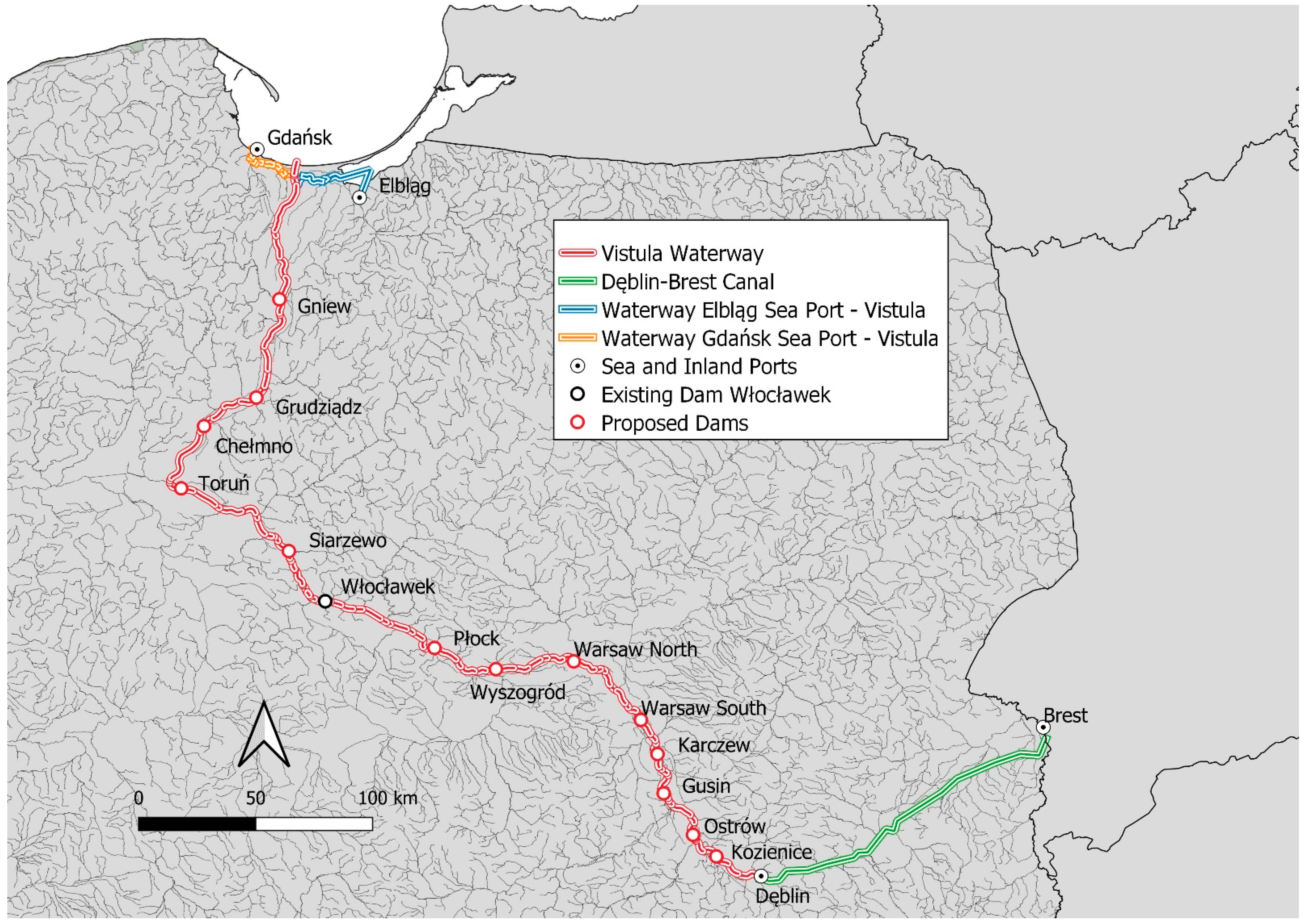
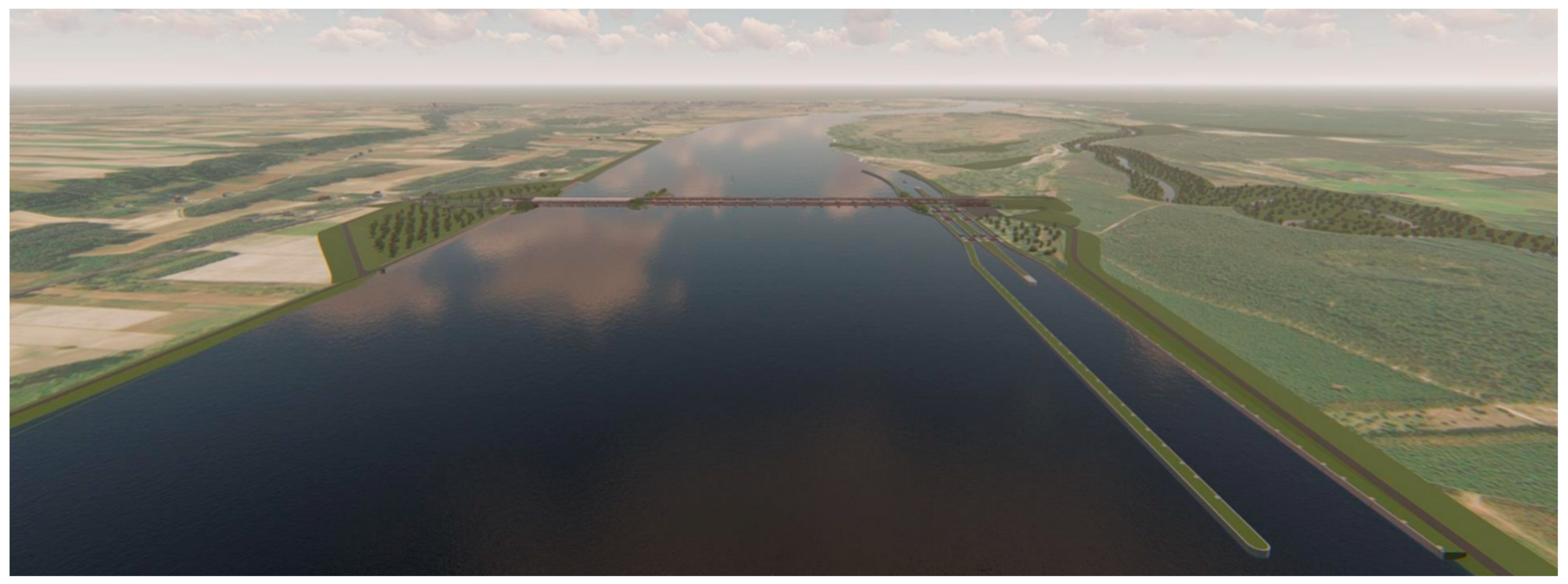
2.1. Prerequisites and Proposed Development

Earlier studies and analyses indicate three possible methods of navigating the Vistula River [16]. The first assumes mixed regulatory development, using alternately longitudinal dams on the concave edges and spur dikes on the remaining sections. The second navigating method for the river is a modification of the Vistula River by using the method of ecological river stabilization (ERS). This method consists of the regulation of the river with a system of low head dams (up to 4.0 m) and maintaining the water in the river at the medium and high-medium levels [24]. The third method involves river regulation achieved by building a series of run-of-river hydropower plants to maintain water levels.
If the river channel engineering works considered for river regulation are limited to training structures, built in order for the stabilization and protection of banks, technical interference in the river is the lowest, and the Vistula maintains its continuity as an ecological corridor for fish. However, river channelization will still lead to the loss of river channel margin interactions and the reduction of habitat diversity [25]. Additionally, based on the analyses, not only will it not be possible to obtain the parameters of an international class waterway, but an inefficient class II waterway will not fulfill expectations.
The solution with the use of low head dams (ERS) has many advantages, including limiting changes to ecosystems. There is the possibility of preserving naturally valuable riverside areas, such as riparian forests and ecological corridors, as well as organic areas of the lagoon in the inter-embankment zones, i.e., areas subjected to yearly floodwater overflows. Additionally, thanks to the use of inflatable weirs, the ERS method provides good conditions for the continuity of sediment transport and, thus, for the organic silting of reservoirs. In addition to many advantages, this solution also has many disadvantages, which are mainly related to economic (a greater number of dams, and no bridges), administrative (more procedures), environmental (more construction sites), and technical (difficult ice-breaking and sluicing) aspects.
A system of reservoirs will be built in such a way that the backwater at the lower reservoir reaches the tailwater of the upstream dam. The dams have been designed as multi-purpose facilities, consisting of navigable locks, hydroelectric power plants, bypass channels, fish ladders, and bridge crossings, which are supported by the power plants, and spillway pillars. The merits of the placement of the structures related to the dam, including environmental, technical, transport, as well as economic and social features could be discussed in view of many aspects [26,27,28]. The reservoir section of the river provides an impound and facilitates the transport system of the river. Furthermore, the establishment of fish ladders as bypass channels mitigates problems concerning the diversity of aquatic species [29]. However, regarding the drawbacks of positioning a dam on the river channel, these are mainly related to the environmental aspects, by way of a blockage in the river path affecting fish breeding [30,31]. Moreover, this causes confusion in the migratory bird journey [32]. Places for foraging, resting, nesting, and breeding are vital for birds. The impoundment established by the construction of the dam may affect these crucial areas related to the life cycle of birds [33,34,35]. Additionally, variations in the hydrodynamic aspects, i.e., the velocity resulting from water level increases, will affect the thermal conditions and, as a consequence, the quality of the water [36].
To remedy the occurring environmental problems, ecological compensation seems advantageous, i.e., positioning mitigating structures, allocating specific funds, setting regulations, and societal education [37]. Ensuring an environmental flow runs in the channel for the duration of drought periods is one worthy ecological remedy. Adapting the regulations in dam design for the storage and release of the occasionally high flow is a key element in managing the environmental flow [38,39].
One of the eco-engineering aspects in the rehabilitation of structures is the design of environmentally friendly structures with locally synchronized materials, i.e., logged or boulder structures [40,41]. Fish passages are structures directly related to dams and classified in different groups, for instance, ladder and bypass channels. Artificial islands are important from the ecological aspect to provide suitable habitats for nesting birds [42,43,44]. All of the above-mentioned measures are of importance for the enhancement of environmental conditions in the Vistula River, and they will be widely implemented in the process of ecological remedy.
As a result of the broadly understood analyses carried out as part of Phase I of the Feasibility Study for the Comprehensive International Inland Waterway Management [23], some of the solutions identified in the "long list" were eliminated and, thus, the number of alternative options for the modernization of the waterway was limited in each section [45]. The solutions that met the conditions for obtaining a minimum class IV of navigability and seemed realistic from the point of view of other conditions were developed in the form of the so-called “short list of alternatives”. All of the choices were developed in such a way to additionally guarantee the possibility of continuous and effective navigation on the Lower and Middle Vistula River. The development also ensured the connection of the Vistula River with the Elbląg sea port and the Vistula Lagoon and, furthermore, as a result, conditions for routing with Gdańsk Sea Port. Based on EU development plans for inland waterways in Poland, to mitigate the impact of transport on the environment, environmentally friendly modes of transport, and more sustainable combination modes of transport, need to be applied. Thus, the share of Gdańsk and Elbląg sea ports, in terms of inland waterway transport (more sustainable combination provision), was enhanced, enabling a connection to the East (the so-called “bottleneck” in the European water transport network will be eliminated).
A multi-criteria analysis based on the main and indirect factors was identified for the “short list of alternatives”. The three best alternative options for the modernization of the Vistula River Waterway (VRW) were selected. For the analysis, the technical, environmental, transport, economic, social, and functional criteria were taken into account. This allowed the creation of a ranking list.
All three alternatives that were at the top of the ranking list provided for the construction of a cascade of 14 dams (13 new dams and the existing Włocławek Dam) on the Vistula River from the city of Dęblin to the Martwa Wisła river route system, within the E-40 waterway. Alternative number 1 assumes a system of dams on the E-40 waterway of the Vistula River, similar to alternative number 2. While option number 3 differs in the location of three dams (Płock Dam, Wyszogród Dam, and Warsaw North Dam). Alternative 2 has been schematically presented in Figure 1.
The inland waterway created as a result of the investment will be almost 730 km long, and its entire length will meet the parameters of an international waterway. As part of the waterway, in addition to the aforementioned barrages, a series of other hydrotechnical facilities will be built, including a 154-km long navigation canal, six locks, and retention reservoirs allocating water to the canal. In addition, a number of engineering structures will be constructed, such as 32 new road bridges and 2 railroad bridges [46]. The new investment will drastically change the current situation on Polish waterways. The inland waterway transport load is about 7 million tons per year, which is only 0.4% of the transport market share. One-fourth of this number comprises transport between ports located outside the territory of Poland [47].
Figure 1. The waterway route according to alternative number 2 with the location of the existing (Włocławek) and proposed dams on the Vistula River [48].
Energies 15 01711 g001
Within the multi-criteria analysis, every main criterion is classified and attributed with a number of sub-criteria, i.e., the economic criterion consists of investment and maintenance costs (Figure 2). The criteria are weighted, based upon their effect on the decision-making process, with the aim of selecting different alternatives (the summation of the weights is considered to be one for each main criterion and sub-criterion. In Figure 2, an overview of the different criteria and sub-criteria is provided in a flowchart description.
Figure 2. The flowchart related to grading the alternatives based on their main criteria and sub-criteria [45].
Energies 15 01711 g002
The main goal of regulating the Vistula is to adjust the river parameters to the requirements of international inland waterways, and to create conditions sufficient for cargo shipping [49]. The basic criterion determining the scope of activities is the required transit depth. In practice, regulation consists of building a system of dams. Their task would be to control the depth of water. These objects are located along the river section at certain distances from each other. The longitudinal profile of the water table in such an arrangement takes a stepped shape. The passage of the transport of bulk goods in a flat-bottomed barge between dams is possible thanks to locks. This method of adapting inland waters to navigation assumes that the depths and cross-sections of the navigable route will be independent from the flows and the slope and shape of the river bottom.
The cascading of the Vistula should be considered as a necessary condition for the activation of river transport. Due to the terrain and the hydrographic characteristics of the river, it is not possible to obtain the appropriate navigational parameters for effective (technically and economically) navigation on the entire section under consideration of the Vistula River by any other means (e.g., through regulation) than through hydrotechnical development.
Apart from navigating the Vistula River, which is the main goal of this task, cascading will fulfill several other important functions from the point of view of water management. The most important problem at the moment in the Lower Vistula valley is safety related to the bottom erosion downstream of the Włocławek Dam. The solution to this problem will undoubtedly be the construction of another dam downstream of the existing one, which will provide the adequate hydraulic support. River regulation with a series of run-of-river impoundments will also improve the level of flood protection in the Vistula valley. This will take place mainly through the modernization of the embankment system of the Vistula River, closely related to the implementation of water dams and ensuring appropriate water depths for the operation of icebreakers and, thus, reducing the risk of jamming. The mere reduction (flattening) of the flood wave through reservoir retention (although it is not possible to be eradicated), will have less impact on reducing the risk of flooding. The dams will also be used for the production of renewable energy, and where the terrain conditions allow, they will also act as road crossings, supplementing the local communication infrastructure system (Figure 3).
Figure 3. Conceptualization of the barrage on the Vistula River (Siarzewo Dam) [50].
Energies 15 01711 g003
The building of barrages is also an improvement in water management and limits the effects of drought in the adjacent areas, which is in line with drought counteraction plans. As a result of damming, the water level in the river increases, which is important in periods of low flow. This process, in turn, raises and stabilizes the groundwater table. The dams do not reduce the magnitude of the outflow from the river basin, but they lead to more steady flow during rainy and dry periods. The stabilization of water levels between the sites also makes it possible to develop adjacent areas that may be attractive locations, e.g., for ports, marinas or shipyards.
The initial concept of cascading the Vistula River on the section from the Martwa Wisła to Dęblin was implemented in two stages. The section from the Martwa Wisła to the Włocławek Dam was the subject of the study “Analysis of the adaptation of the Vistula River in the section from Włocławek to the mouth of the Gulf of Gdańsk for large and small cascades–modeling” by DHV Hydroprojekt, Ltd. (Warsaw, Poland) and the Institute of Meteorology and Water Resources, National Research Institute, Gdynia Maritime Branch [22]. The section from the Włocławek Dam to Dęblin was developed as part of the “Feasibility Study for Comprehensive International Inland Waterway Management” by the Jacobs Halcrow Group Ltd. (Włocławek, Poland) [23]. The basis for the solutions proposed here was archival documentation at various levels of detail created in the years 1945–2014. The result of the work of both teams was a proposal to develop the section of the Vistula River from the Martwa Wisła to Dęblin with 13 new dams, 5 of which will be located downstream of the Włocławek Dam.

2.2. Hydropower Potential of the Vistula River Cascade

Due to the fact that the functionality of the proposed river cascade should not be limited only to ensuring the transit depths required for navigation, the construction of a hydroelectric power plant was planned at each of the dams. The construction of the dam system will allow the exploitation of the hydropower potential of the Vistula River by producing renewable energy. The construction of the run-of-river reservoir and parallel hydropower plants were initially adopted. Dam power plants have many advantages, but as with all technical solutions, they also have some disadvantages. The greatest disadvantage of a power plant located on the site of a dam is the concentration of the flow on one bank for most of the year, which may cause increased erosion and is associated with the need to apply appropriate technical measures in the form of heavy bottom and bank protection.
According to the above list shown in Table 1, the capacities of all planned power plants in the Vistula cascade are in the range of 15–100 MW, which means that they are classified as medium-sized hydropower plants. However, the installed discharge (Qinst) has been provided based on the Feasibility Study [13], and must be considered as an estimation only, based on the information of the average multi-year flow (Qave). In the case of more detailed analyses, the installed flow is selected as a result of iterative optimization. The installed flow obtained in this way is usually much higher than the average annual flow. This type of verification calculation should be performed at further design stages, together with the selection of the minimum and maximum energy levels. It is assumed that the low energy level will be taken at the normal pool level since maintaining this level at low flows is the main assumption of water management in reservoirs in relation to their navigational function. More detailed analyses should decide on the selection of the maximum energy level. The data for the correct selection of the installed flow, thus the actual power of the plant and the average annual energy production, are provided by the cumulative flow curve. The calculations should take into account the necessity to provide lock water and adequate flow in fish passages, including the circulation channel. The method and conditions of power plant operation should be strictly defined in the water management manual for the facility.
Table 1. Technical parameters of the proposed and existing dams on the Vistula River [45].
Location (Name)PoolHeadQaveQinstCapacityEnergy
Production
Issued Year
(m)(m)(m3/s)(m3/s)(MW)GWh/year
Kozienice II111.306.62507.15608.5831.63151.922060
Ostrów II104.304.09514.78617.7019.8090.242058
Gusin98.005.00563.19675.8026.50127.202055
Karczew91.805.22564.34677.2027.70132.962053
Warsaw South86.005.71575.95691.2031.00148.802050
Warsaw North II77.005.61606.00727.2032.00156.002048
Wyszogród II70.506.49888.001065.6054.24260.162045
Płock II63.004.81932.001118.4042.22202.562049
Włocławek *57.148.80921.002190.00160.20700.001970
Siarzewo46.007.82/4.86939.001800.0080.00384.002029
Solec Kujawski37.507.501014.002300.0079.00379.202040
Chełmno29.008.001052.002350.0068.00326.402038
Grudziądz22.004.001070.001800.0056.50271.202035
Gniew15.005.701075.001700.0076.00364.802033
* Existing dam.
For energy dissipation, a basin downstream of the power plant is designed to produce uniform flow distribution across the channel. For this purpose, it is proposed to shape the river bed to a basin with a slope in the range from 1:5 to 1:10. Downstream of the exit of the power plant, as with the spillway, the river bed will be armored with caged riprap (gabions) and the river banks with riprap placed on geotextile. The purpose is to eliminate erosion of the bed and banks, which may be affected by flow convergence. Detailed parameters of the energy dissipation basin will be designed based on the geometry and equipment of each individual power plant.

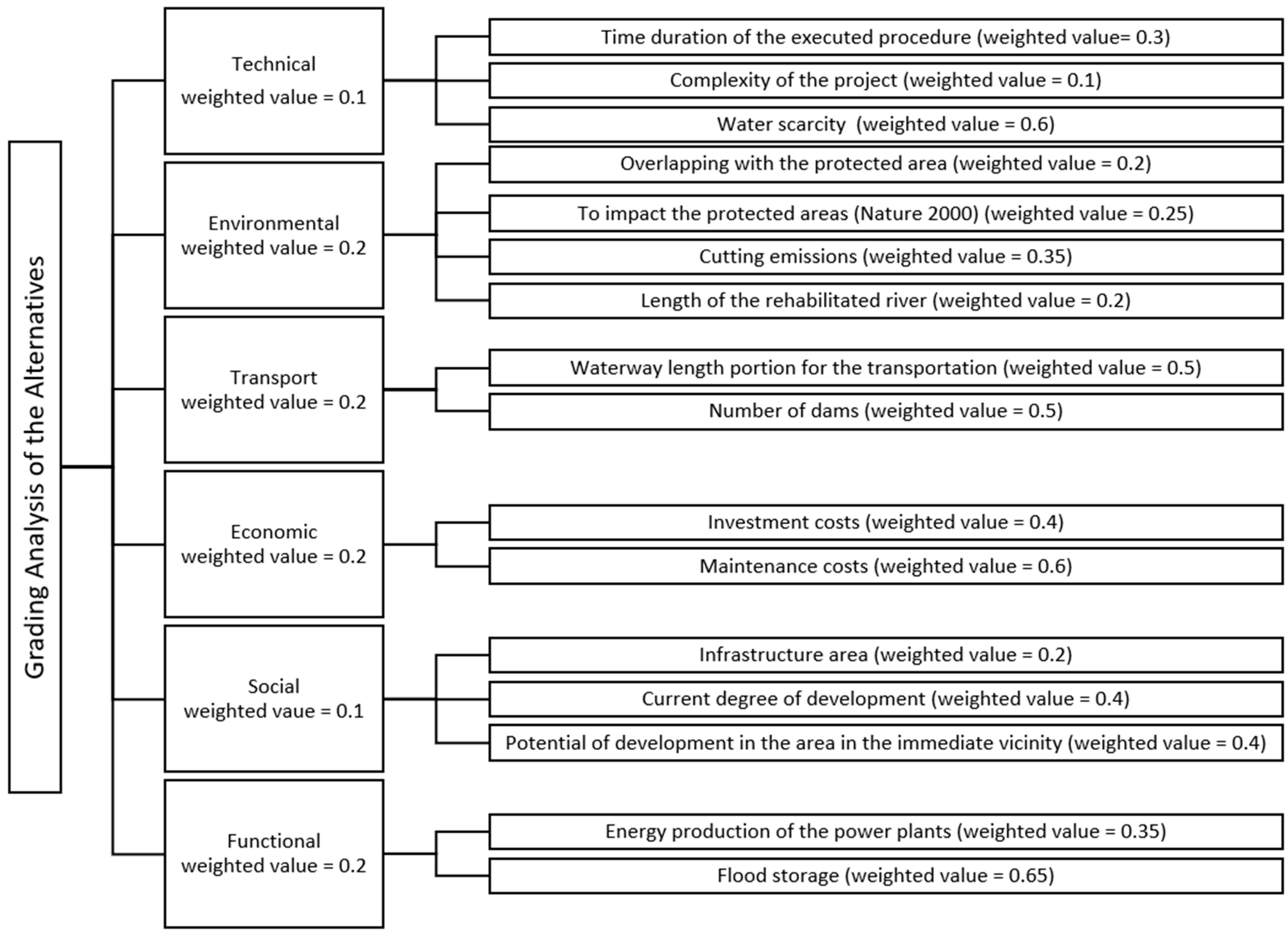
3. Economic Analysis of the Project

Based on the feasibility study [13], an economic analysis was developed [45], which indicated alternative number 2 as the recommended investment (Figure 1). Alternative number 2 was compared with the “no project implementation” (Table 2), which led to a comparison with the case of no improvement in the Vistula River conditions. As part of the performed cost–benefit analysis, it was shown that all of the analyzed investment alternatives are economically effective, which leads to the conclusion that the implementation of the project is economically profitable and, therefore, it is equally socially justified.
In the feasibility study [45], the possibility of estimating project revenues from various sources was analyzed. Project operating income was limited to two subcategories:
  • Revenues from the use of inland waterways and their sections—passenger transport and freight transport;
  • Revenues from the sale of electricity.
The limitation in the scope of calculating the project’s revenues is due to the fact that the calculation of other revenue categories (such as, for example, rental fees and use of land covered with water) is very difficult, as it is impossible to define the basic assumptions for calculations at the present stage of the project. In the paper, the discussion will be limited to revenues from the sale of electricity.
The implementation of the investment in question provides for the construction of hydroelectric power plants. Revenues from the sale of electricity were estimated as the outcome of the annual production of electricity, expressed in MWh, and the unit price of 1 MWh of electricity. The calculation was divided into the calculation of revenues from the sale of electricity from hydroelectric power plants (HPPs) with installed capacity below and above 20 MW. This is because HPPs below 20 MW may apply for financial support in an auction system (guaranteed income from the sale of electricity), while HPPs with an installed capacity above 20 MW cannot apply for financial support and, therefore, there is a need to differentiate the sale prices of electric energy. As part of the planned investments, only the Ostrów II power plant (19.8 MW) will be able to apply for support; therefore, the selling price of electricity was estimated based on auctions for the purchase of electricity.
The calculation for the Ostrów power plant (below 20 MW) was based on the average price of the announced auction result of the guaranteed price for the purchase of electricity for 2018, considering inflation. The selling price of electricity for HPPs above 20 MW is the average selling price of electricity in the competitive market for 2019 and has been indexed by inflation to the base year (2022). The amount of electricity produced was calculated based on technical analyses and the capacity of individual power plants, taking into account a correction for efficiency and actual power use. Due to the distribution of investment projects over time, individual power plants are to be commissioned in stages, and thus the value of revenues will increase along with the commissioning of hydropower plants until 2059.
The economic net present value (NPV) is positive, which means that the economic flows of the project, expressed in present value, over the entire period of the analysis reached a cumulative positive value, and therefore the economic benefits are higher than the costs related to the implementation of the project. Table 3 presents the discounted costs and benefits resulting from the implementation of the investment in question. The largest share in total benefits is shown by savings in transport costs for cargo owners, while in the case of costs, these are investment outlays.
The benefit–cost (B/C) ratio shows the ratio of economic benefits resulting from carrying out the project to the costs incurred. If the B/C ratio for the project is greater than one—the project benefits the community. In all investment variants, this condition is met. The value of the indicator greater than one indicates an achievement in the effectiveness of the project in generating socioeconomic benefits, expressed in money. This value should be interpreted as a return on investment in social terms higher than the funds involved, i.e., each PLN of expenditure allocated to the project generates PLN 2.81 in alternative number 2.
The internal rate of return (IRR) is higher (4.50%) than the social discount rate (SDR) used for the analysis. This means that the investment has the ability to generate benefits—it will bring higher-than-expected benefits in terms of society. IRR in alternative 2 is 12.31%.

4. Summary and Conclusions

The analysis of economic effectiveness shows that the project is profitable from a socioeconomic point of view, generating a surplus of benefits over costs in the amount of approximately 177–181% depending on the analyzed condition. The project to be implemented is of a transport nature (modernization of waterways) and, therefore, as much as about 41.1% of the benefits generated by the project are transport benefits (savings in accident costs, pollution of the atmosphere, climate change, noise, congestion, and transport costs for cargo owners). As part of the project, a range of anti-flood measures are also implemented, which generate savings in the cost of flood losses, constituting approximately 19.60% of all benefits generated by the project. The above is due to the fact that the implementation of embankments along the Vistula River will make it possible to eliminate direct and indirect flood losses, estimated at the level of approximately PLN 2 billion per year. Another significant benefit is economic growth resulting from the stimulation of collective and individual tourism in connection with the possibility of using the water infrastructure for tourist purposes (approximately 8.7%), revenues from the sale of electricity because of the construction of hydroelectric power plants on the dams (approximately 6.6%), and the reduction of losses resulting from forest fires (approximately 5.1%). Additionally, savings in CO2 emissions in electricity production account for approximately 3.2% of all benefits. The remaining categories of benefits are the economic residual value (approximately 15.7%) and the reduction in losses caused by drought in agriculture (approximately 0.1%). On the other hand, in the case of costs, the largest share are investment outlays of approximately 63.2% as well as maintenance and operation costs of approximately 36.8%.
The main objective of this project is to conduct a profitable water management plan, taking into account the ecological and social approval conditions. Thanks to decent investment in the project, the abovementioned goals seem likely to be achieved. From a socioeconomic point of view, the project is therefore beneficial and will have a positive impact on various aspects of the economy and the life of citizens. Good transport growth as a result of shifting the means of transport from land vehicles to watercraft, flood loss, and drought reduction can be considered among the positive results. Apart from the aforementioned achievements, an improvement in hydropower generation is evident, due to more advanced water system management.
Following the evaluation of the project requirements, one of the most important aspects to be considered is the economic aspect. Any lack of attention to the Vistula River Waterway will lead to the marginalization of the inland water area and irreversible degradation. Therefore, profound investment is needed to remedy the situation and, subsequently, obtain an adequate transport area, and social and economic benefits. To cover the expense of this large project, it is recommended to divide the program into various stages, each of which can be financed through different financial outlays, funds and instruments. This results in more efficient coordination and communication and, thus, better economic and financial results are obtained. It must also be noted that to finalize the execution of this planned project, a long timeframe is required. During the implementation of the investment, there may be a need to adapt the designed solutions to climate changes (hydrological conditions in the investment area), and the geopolitical or political situation, or to take into account the impact of new technologies on the transport system.

Author Contributions

Conceptualization: K.W. (Krzysztof Woś), K.W. (Krzysztof Wrzosek), T.K.; methodology: T.K.; formal analysis: K.W. (Krzysztof Wrzosek); data curation: K.W. (Krzysztof Wrzosek); writing—original draft preparation: T.K., K.W. (Krzysztof Wrzosek); writing—review and editing: T.K., K.W. (Krzysztof Woś); visualization: T.K. All authors have read and agreed to the published version of the manuscript.

Funding

This research was funded by State Water Holding Polish Waters.

Institutional Review Board Statement

Not applicable.

Informed Consent Statement

Not applicable.

Data Availability Statement

All data in this study are provided by State Water Holding Polish Waters.

Acknowledgments

The authors express their gratitude to the staff of State Water Holding Polish Waters for the support and assistance in the preparation of the project and for the materials provided.

Conflicts of Interest

The authors declare no conflict of interest.

References

  1. Míguez, J.L.; Porteiro, J.; Lopez-Gonzalez, L.M.; Vicuna, J.E.; Murillo, S.; Moran, J.C.; Granada, E. Review of the Energy Rating of Dwellings in the European Union as a Mechanism for Sustainable Energy. Renew. Sustain. Energy Rev. 2006, 10, 24–45. [Google Scholar] [CrossRef]
  2. Melo, I.; Torres, J.P.N.; Fernandes, C.A.F.; Lameirinhas, R.A.M. Sustainability Economic Study of the Islands of the Azores Archipelago Using Photovoltaic Panels, Wind Energy and Storage System. Renew. Wind. Water Sol. 2020, 7, 1–21. [Google Scholar] [CrossRef]
  3. Frey, G.W.; Linke, D.M. Hydropower as a Renewable and Sustainable Energy Resource Meeting Global Energy Challenges in a Reasonable Way. Energy Policy 2002, 30, 1261–1265. [Google Scholar] [CrossRef]
  4. Steller, J.; Lewandowski, S.; Malicka, E.; Kremere, E.; Popa, B.; Punys, P. Hydropower in the East European Region: Challenges and Opportunities. Hydropower Dams 2018, 25, 39–50. [Google Scholar]
  5. EUROSTAT Data Browser. Available online: http://ec.europa.eu/eurostat/data/database (accessed on 10 February 2022).
  6. European Parliament. Directive (EU) 2018/2001 of the European Parliament and of the Council of 11 December 2018 on the Promotion of the Use of Energy from Renewable Sources; European Parliament and the Council: Strasbourg, France, 2018; p. 128.
  7. Woś, K. Kierunki Aktywizacji Działalności Żeglugi Śródlądowej w Rejonie Ujścia Odry w Warunkach Integracji Polski z Unią Europejską; Sadyba: Warsaw, Poland, 2005. [Google Scholar]
  8. European Agreement on Main Inland Waterways of International Importance (AGN); United Nations: Geneva, Switzerland, 1996; p. 122.
  9. United Nations Economic Commission for Europe. Inventory of Main Standards and Parameters of the Waterway Network; United Nations Economic Commission for Europe: New York, NY, USA; Geneva, Switzerland, 2017; p. 116. [Google Scholar]
  10. ECMT. Resolution No. 92/2 on New Classification of Inland Waterways; European Conference of Ministers of Transport: Athens, Greece, 1992.
  11. Szydlowski, M.; Gąsiorowski, D.; Szymkiewicz, R.; Zima, P.; Hakiel, J. Hydropower Potential of the Lower Vistula. Acta Energetica 2015, 1, 18–25. [Google Scholar] [CrossRef]
  12. Cyberski, J.; Grześ, M.; Gutry-Korycka, M.; Nachlik, E.; Kundzewicz, Z.W. History of Floods on the River Vistula. Hydrol. Sci. J. 2006, 51, 799–817. [Google Scholar] [CrossRef]
  13. Granatowicz, J. The next Dam on the Vistula River below Włocławek. Acta Energetica 2013, 3, 99–111. [Google Scholar] [CrossRef]
  14. Kosiński, J.; Zdulski, W. Hydropower Potential of the Vistula. Acta Energetica 2013, 2, 38–47. [Google Scholar] [CrossRef]
  15. Piskozub, A. Wisla: Monografia rzeki (The Vistula River. A Monography of the River); Wydawn. Komunikacji i Łạczności: Warsaw, Poland, 1982. [Google Scholar]
  16. Szymkiewicz, R. Lower Vistula—River of Unused Opportunities; Gdańsk University of Technology: Gdansk, Poland, 2017; ISBN 978-83-7348-707-9. [Google Scholar]
  17. Stepnowski, C.Z. Kaskada dolnej Wisły (Cascade of the Lower Vistula River). Gospod. Wodna 1958, 8, 124–128. [Google Scholar]
  18. Majewski, W. Gospodarka Wodna w Polsce w Latach‚ 50–80 (Water Resources Managemant in Poland from the 1950s to the 1970s); Chancellery of the Senate of the Republic of Poland: Warsaw, Poland, 2011. [Google Scholar]
  19. Majewski, W. The Hydraulic Project Włocławek: Design, Studies, Construction and Operation. Acta Energetica 2015, 1, 33–45. [Google Scholar] [CrossRef]
  20. Skowyrski, W.; Ankiersztejn, I. Budowa Stopnia Wodnego w Nieszawie—Ciechocinku; Koncepcja Programowo—Przestrzenna (Construction of the Dam in Nieszawa—Ciechocinek; Program and Spatial Concept); HYDROPROJEKT: Warsaw, Poland, 2004. [Google Scholar]
  21. Ministry of Maritime Economy and Inland Navigation. Ekspertyza w Zakresie Rozwoju Śródlądowych Dróg Wodnych w Polsce na Lata 2016-2020 z Perspektywą do Roku 2030 (Expertise in the Field of the Development of Inland Waterways in Poland for the Years 2016-2020 with a Perspective until 2030); Ministry of Maritime Economy and Inland Navigation: Warsaw, Poland, 2016. [Google Scholar]
  22. DHV Hydroprojekt Ltd.; IMGW PIB. Analysis of the Adaptation of the Vistula River in the Section from Włocławek to the Mouth of the Gulf of Gdańsk for Large and Small Cascades-Modeling; State Water Holding Polish Waters: Gdansk, Poland, 2018; p. 69. [Google Scholar]
  23. JACOBS Halcrow Group Ltd. Studium Wykonalności dla Kompleksowego Zagospodarowania Międzynarodowych dróg Wodnych: E-40 dla rzeki Wisły na Odcinku od Gdańska do Warszawy, E-40 od Warszawy do Granicy Polska-Białoruś (Brześć) oraz E-70 na Odcinku od Wisły do Zalewu Wiślanego (Elbląg) (Feasibility Study for Comprehensive International Inland Waterway Management: E-40 for Vistula River between Gdansk and Warsaw, E-40 from Warsaw to the Poland-Belarus Border (Brest) and E-70 between the Vistula River and the Vistula Lagoon (Elblag)); State Water Holding Polish Waters: Gdańsk, Poland, 2020. [Google Scholar]
  24. Gajda, M. Characteristic of the Barrage as a Part of the Ecological River Stabilization. Water Resour. 2013, 9, 359–360. [Google Scholar]
  25. Petts, G.E. River Regulation. In Environmental Geology. Encyclopedia of Earth Science; Springer: Dordrecht, The Netherlands, 1999; pp. 521–528. ISBN 978-1-4020-4494-6. [Google Scholar]
  26. Égré, D.; Senécal, P. Social Impact Assessments of Large Dams throughout the World: Lessons Learned over Two Decades. Impact Assess. Proj. Apprais. 2003, 21, 215–224. [Google Scholar] [CrossRef] [Green Version]
  27. Tilt, B.; Braun, Y.; He, D. Social Impacts of Large Dam Projects: A Comparison of International Case Studies and Implications for Best Practice. J. Environ. Manag. 2009, 90, S249–S257. [Google Scholar] [CrossRef]
  28. Kibler, K.M.; Tullos, D.D. Cumulative Biophysical Impact of Small and Large Hydropower Development in Nu River, China. Water Resour. Res. 2013, 49, 3104–3118. [Google Scholar] [CrossRef]
  29. Roscoe, D.W.; Hinch, S.G. Effectiveness Monitoring of Fish Passage Facilities: Historical Trends, Geographic Patterns and Future Directions. Fish Fish. 2010, 11, 12–33. [Google Scholar] [CrossRef]
  30. Larinier, M. Environmental Issues, Dams and Fish Migration. In Dams, Fish and Fisheries: Opportunities, Challenges and Conflict Resolution; FAO Fisheries Technical Paper; FAO: Rome, Italy, 2001; Volume 419, pp. 45–89. [Google Scholar]
  31. Poff, N.L.; Schmidt, J.C. How Dams Can Go with the Flow. Science 2016, 353, 1099–1100. [Google Scholar] [CrossRef]
  32. Reitan, O.; Thingstad, P.G. Responses of Birds to Damming-a Review of the Influence of Lakes, Dams and Reservoirs on Bird Ecology. Ornis Nor. 1999, 22, 3–37. [Google Scholar]
  33. Ackermann, W.C.; White, G.F.; Worthington, E.B.; Ivens, J.L. Man-Made Lakes: Their Problems and Environmental Effects; Washington DC American Geophysical Union Geophysical Monograph Series; American Geophysical Union: Washington, DC, USA, 1973; Volume 17. [Google Scholar] [CrossRef]
  34. Liao, W.; Bhargava, D.S.; Das, J. Some Effects of Dams on Wildlife. Environ. Conserv. 1988, 15, 68–70. [Google Scholar] [CrossRef]
  35. Nilsson, C.; Dynesius, M. Ecological Effects of River Regulation on Mammals and Birds: A Review. Regul. Rivers Res. Manag. 1994, 9, 45–53. [Google Scholar] [CrossRef]
  36. Winton, R.S.; Calamita, E.; Wehrli, B. Reviews and Syntheses: Dams, Water Quality and Tropical Reservoir Stratification. Biogeosciences 2019, 16, 1657–1671. [Google Scholar] [CrossRef] [Green Version]
  37. Yu, B.; Xu, L. Review of Ecological Compensation in Hydropower Development. Renew. Sustain. Energy Rev. 2016, 55, 729–738. [Google Scholar] [CrossRef]
  38. Arthington, Á.H.; Naiman, R.J.; Mcclain, M.E.; Nilsson, C. Preserving the Biodiversity and Ecological Services of Rivers: New Challenges and Research Opportunities. Freshw. Biol. 2010, 55, 1–16. [Google Scholar] [CrossRef] [Green Version]
  39. Renöfält, B.M.; Jansson, R.; Nilsson, C. Effects of Hydropower Generation and Opportunities for Environmental Flow Management in Swedish Riverine Ecosystems. Freshw. Biol. 2010, 55, 49–67. [Google Scholar] [CrossRef]
  40. Roni, P.; Pess, G.R.; Beechie, T.J.; Hanson, K.M. Fish-Habitat Relationships and the Effectiveness of Habitat Restoration; US Department of Commerce: Washington, DC, USA, 2014. [Google Scholar]
  41. Roni, P.; Hanson, K.; Beechie, T. Global Review of the Physical and Biological Effectiveness of Stream Habitat Rehabilitation Techniques. N. Am. J. Fish. Manag. 2008, 28, 856–890. [Google Scholar] [CrossRef]
  42. Quinn, J.S.; Morris, R.D.; Blokpoel, H.; Weseloh, D.V.; Ewins, P.J. Design and Management of Bird Nesting Habitat: Tactics for Conserving Colonial Waterbird Biodiversity on Artificial Islands in Hamilton Harbour, Ontario. Can. J. Fish. Aquat. Sci. 1996, 53, 45–57. [Google Scholar] [CrossRef]
  43. Kolerski, T.; Zima, P.; Szydłowski, M. Mathematical Modeling of Ice Thrusting on the Shore of the Vistula Lagoon (Baltic Sea) and the Proposed Artificial Island. Water 2019, 11, 2297. [Google Scholar] [CrossRef] [Green Version]
  44. Giroux, J.-F. Use of Artificial Islands by Nesting Waterfowl in Southeastern Alberta. J. Wildl. Manag. 1981, 45, 669–679. [Google Scholar] [CrossRef]
  45. JACOBS Halcrow Group Ltd. Analiza ekonomiczna (Cost Benefit Analysis). In Feasibility Study for Comprehensive International inland Waterway Management: E-40 for Vistula River between Gdansk and Warsaw, E-40 from Warsaw to the Poland-Belarus Border (Brest) and E-70 between the Vistula River and the Vistula Lagoon (Elblag); State Water Holding Polish Waters: Gdańsk, Poland, 2020. [Google Scholar]
  46. Wrzosek, K.; Sobiesak, P.; Sikorski, G. Charakterystyczne rozwiązania techniczne planowanych stopni wodnych na rzece Wiśle na odcinku Międzynarodowej Drogi Wodnej E40 (Characteristic technical solutions of the planned barrages on the Vistula River on the section of the International Waterway E40). Gospod. Wodna 2021, 10, 29–32. [Google Scholar]
  47. Rolbiecki, R.; Wojewódzka-Król, K. Changes in the Transport Capacity of Polish Inland Waterways Against the Background of European Waterway Use for Transport. Transp. Econ. Logist. 2019, 81, 155–164. [Google Scholar] [CrossRef]
  48. JACOBS Halcrow Group Ltd. Analiza Techniczna (Technical Analysis). In Feasibility Study for Comprehensive International Inland Waterway Management: E-40 for Vistula River between Gdansk and Warsaw, E-40 from Warsaw to the Poland-Belarus Border (Brest) and E-70 between the Vistula River and the Vistula Lagoon (Elblag); State Water Holding Polish Waters: Gdańsk, Poland, 2020. [Google Scholar]
  49. Woś, K. Plans for the Development of Polish Inland Waterways. Probl. Transp. Logist. 2017, 1, 297–310. [Google Scholar] [CrossRef]
  50. Woś, K.; Wrzosek, K. The Siarzewo Barrage Project as an Example of a New Quality in the Realization of Investments for the Rational Water Resources Management in Poland. Hydropower Dams 2021, 2, 34–40. [Google Scholar]
Table 2. Differential revenues from electricity sales for no project implementation and for alternative 2 of the project [45].
20292030204020502060
(Million PLN)
No project implementation0.130.140.180.230.28
Alternative 295.9595.95431.15619.57763.43
Table 3. Summary of the cost–benefit analysis [45].
BenefitsTotal value (PLN billion) discounted% of total benefits
Savings in transport costs for cargo owners24.8122.80%
Savings in accident costs6.796.24%
Cost saving for atmospheric pollution0.560.51%
Savings in climate change costs2.011.85%
Noise cost savings1.411.29%
Savings in congestion costs9.198.44%
Savings in the cost of flood losses21.2519.54%
Savings in forest fire costs5.485.04%
Savings in drought costs in agriculture0.100.10%
Revenue from the sale of electricity7.166.58%
Savings in CO2 emissions in electricity production3.433.15%
Benefits due to increased expenses in tourism9.518.74%
Economic residual value17.1015.72%
Overall108.79100%
CostsTotal value (PLN billion) discounted% of total costs
Investment outlays24.4963.23%
Maintenance and operation costs14.2436.77%
Overall38.73100%
Economic net present value (NPV)70.06
Publisher’s Note: MDPI stays neutral with regard to jurisdictional claims in published maps and institutional affiliations.

