Article

Analyzing the Formation and Evolution of Strike-Slip Faults and Their Controlling Effects on Hydrocarbon Migration and Charging: A Case Study of Tahe Area, Tarim Basin

1
College of Geoscience and Surveying Engineering, China University of Mining and Technology-Beijing, Beijing 100083, China
2
Petroleum Exploration & Production Research Institute of Northwest Oilfield Company Sinopec, Urumqi 830011, China
*
Author to whom correspondence should be addressed.
Energies 2023, 16(5), 2370; https://doi.org/10.3390/en16052370
Submission received: 12 December 2022 / Revised: 28 January 2023 / Accepted: 27 February 2023 / Published: 1 March 2023
(This article belongs to the Section H1: Petroleum Engineering)

Abstract

:
The Ordovician strike-slip faults system in the Tahe area of the Tarim Basin provides an important opportunity for using 3D seismic data to document the structural characteristics, formation, and evolution of strike-slip faults and their relationship with oil and gas. With high-resolution 3D seismic data, the strike-slip faults are interpreted, classified, and described using the seismic coherence technique. The geometric characteristics, active periods, formation, and evolution process of strike-slip faults are analyzed, and the relationship between strike-slip faults and hydrocarbon accumulation and charging is discussed in this research project. On the map, the primary strike-slip faults on the east and west sides of the Tahe area are relatively sheared to each other, showing an “X” type conjugate fault, and the secondary strike-slip faults are scattered. In the cross-section, the primary strike-slip faults are inserted downward into the Cambrian basement and up to Devonian, and “Single line”, “Y”, “Flower”, and “Parallel lines” structures are observed. Bounded by the top of Ordovician, the deep and shallow parts are vertically segmented, with different structure styles. The switch of the structural style of strike-slip faults is attributed to principal stress. A deep “positive flower” shape of faults was developed in the mid-Ordovician period under the effect of compressive stress. Meanwhile, a shallow “negative flower” shape of faults was developed from the late Ordovician to the mid-Devonian period under tensile stress. The “Compound Flower” shape of deep “positive flower” shape and shallow “negative flower” shape formed by compressive and tensile activities has a wider fracture range, which leads to deep fluid migration and shallow karstification. There are two combinations of deep Ordovician strike-slip faults in the section: “Lower single branch-upper flower type” and “lower single branch-upper single branch type”. The primary faults of the former insertion into the Cambrian basement are associated with homologous secondary faults, while the latter has no derived secondary faults. It has an important impact on reservoir reconstruction and distribution, and the reservoir is controlled by faults. Strike-slip faults not only control the channel of oil and gas migration, but also the horizontal and vertical distribution of oil and gas. The closer the carbonate reservoir is to the primary fault, the more likely it is to form a high yield area. There are four types of oil and gas charging models controlled by strike-slip faults. In the area where the structure is high and the strike-slip faults are sheared relatively to each other, the larger the scale of faults, the more conducive it would be to oil and gas migration and accumulation. Among them, the charging model related to the primary fault has higher oil and gas migration efficiency. This research contributes to analyzing the relationship between strike-slip faults and oil and gas as well as playing a significant role in applications of oil and gas exploration in practical works.

1. Introduction

Previous oil and gas exploration shows that strike-slip faults have an important impact on karst fractured-vuggy reservoirs [1,2,3]. In recent years, industrial oil and gas have been found in the strike-slip fault zone of the Tahe oilfield, which provides sufficient evidence for the good exploration prospect of oil and gas reservoirs controlled by strike-slip faults [4]. Oil and gas reservoirs controlled by strike-slip faults are the focus of future exploration and development. From this perspective, the effective exploration and development of naturally-fractured carbonate reservoirs have become increasingly indispensable in these years. The Tahe oilfield, as the largest carbonate oilfield in China, has experienced multi-stage tectonic movements, and thus formed significant fault systems [5,6,7]. Strike-slip faults play an important role in the migration and accumulation of oil and gas resources. When strike-slip faults are formed, strata are fractured and displaced. The fracture zone is a high permeability area, which facilitates fluid flow and reservoir development [8]. On the one hand, the high permeability fault zone increases the contact between fluid and carbonate rock to accelerate dissolution; on the other hand, the fault system provides a channel for oil and gas migration. Therefore, strike-slip faults can not only be used as migration channels for oil, gas, and other fluids, but also contribute to the formation of carbonate reservoirs [9,10].
As production continues to increase, research analyzing strike-slip faults in the northern Tarim Basin continues to emerge [11,12,13,14,15]. The first is to analyze the relationship among strike-slip faults, karstification, and carbonate properties. The second is to improve the identification of strike-slip faults using high-resolution seismic processing, multi-filtering process, and seismic attributes, such as maximum likelihood [16]. The third is to analyze the structural style, evolution, and genetic mechanism of strike-slip faults [17,18]. The fourth is to model strike-slip faults, analyze geomechanical characteristics, and reveal different stress states of strike-slip faults. Moreover, the influence of faults to oil and gas migration is clarified using fault modeling and fluid analysis [19,20]. People tend to study the strike-slip faults as a whole in the central or northern Tarim Basin or study the formation process of faults over a long time span from Paleozoic Mesozoic to Cenozoic. However, there are few studies on the detailed description of Ordovician strike-slip faults, and the understanding of the evolution mechanism of Ordovician strike-slip faults still lags behind exploration practice. The relationship between strike-slip faults and oil and gas production, especially the oil and gas charging model, is rarely discussed. We carry out a detailed study of Ordovician strike-slip faults, in which we explore the relationship between strike-slip faults and oil and gas production, and charging models, hoping to reduce the risk cost of exploration.
Tarim Basin in northwestern China hosts several oil and gas resources in Cambrian-Ordovician marine carbonate units [21]. The Ordovician carbonate reservoir in Tahe is the fracture-vuggy oilfield with the largest reserves and output in China [22]. Ordovician Yijianfang Formation and Yingshan Formation are limestones, which are the main exploration horizons at present, with a burial depth of more than 5000 m. Oil companies, such as Sinopec, conduct exploration in fault zones and uplift zones (such as Tabei and central fault zones, Tabei and central uplift). A series of oil and gas fields and high-yield wells were also discovered in this process. Many high yield wells are located on fault zones, suggesting that strike-slip faults are closely related to oil and gas. Numerous researchers have focused on the relationship between the formation and evolution of strike-slip faults. Under integrated influences of compressive, shear, and torsional stress, the horizontal displacement of both sides of the fault would occur to varying degrees in different evolution periods. The mechanical properties and structural styles have changed significantly, which forms various strike-slip transition structures. Therefore, the distribution and production of oil and gas will also change greatly. This paper’s objective is to explain the Ordovician strike-slip fault system from the perspectives of fault description, geometry, and formation process. The combination of strike-slip faults and distribution characteristics of oil and gas reveals the accumulation and charging model in the Tahe area. Consequently, this study provides theoretical direction for the future exploitation of fault-controlled oil and gas reservoirs, as well as an understanding of the development process of strike-slip faults in the Ordovician in the Tahe area.

2. Geological Setting

2.1. Tectonic Setting

The Tarim Basin is the largest inland basin in northwestern China (Figure 1a), with an area of 560,000 km2 [23]. The Tahe oilfield is located on the north slope of the Tarim Basin (Figure 1b). The Tahe Ordovician oil reservoir belongs to the south slope of Akekule uplift in the middle section of Shaya uplift in the Tarim Basin [24,25], and thus resembles a nose-shape structure with high northeast and low southwest areas. It is adjacent to the Halahatang depression in the west, Caohu depression in the east, and Manjiaer depression in the south [26,27,28] (Figure 1c). Several strike-slip faults are developed in the Tahe oilfield and the majority of these faults were formed in the Caledonian orogeny and Hercynian orogeny [29,30]. Fault depths are more than 5000 m and they generally extend to the basement. The Tarim Basin is affected by multistage structures [27,31]. More importantly, under integrated influences of multiple tectonic stresses, including tension, compression, strike-slip, gravity, and diapirism, multi-stage and multi-group fault structures are formed. They superimpose on each other, transform and enrich the structural features of petroliferous basins, and affect the formation and distribution of oil and gas reservoirs in the basin [32,33]. Accumulation in the Tarim Basin has experienced a multi-stage process of establishment, destruction, adjustment, and reconstruction [34], which has increasingly changed and enriched the structural characteristics of the oil and gas basin and affected the formation and distribution of oil and gas reservoirs. Previous research showed that the hydrocarbon source in the Tahe area mainly comes from the southern Manjiaer sag and eastern Caohu sag (Figure 1b) [35,36].
The Tahe area is located on the south slope of the Akekule uplift developed on the Pre-Sinian Basement and Mineralization. Many tectonic movements have uplifted this area, with the most important ones being the Ordovician-Silurian Caledonian orogeny and late Permian-Hercynian orogeny [38,39]. During the early Caledonian orogeny, the whole Akekule uplift area was located on the slope of the Craton depression, and the Cambrian-Ordovician strata gradually thinned from south to north [40,41]. At the end of Ordovician, the strong mid-Caledonian orogeny made the early uplift more intensified, forming the Akekule uplift. The uplift is high in the north and low in the south, then the north was eroded and Silurian transgressive strata overlapped and deposited with Ordovician strata in this area [42]. After the late Paleozoic Devonian, the principal stress of the strata changed from south-north to northwest-southeast during the Hercynian orogeny. The axial direction of the Akekule uplift changed, with the southwest collapsing and the northeast uplifting and forming a large nose-like uplift structure. The long-term erosion of the uplift resulted in severe erosion of the Devonian, Silurian, and Ordovician strata [43]. The pressure around the Ordovician strata weakened, forming a series of NE-NW trending faults in the orogeny.

2.2. Stratigraphy

The Akekule uplift within the Tahe area is an ancient uplift developed on the basis of a pre-Sinian metamorphic rock basement [44,45]. At present, the strata revealed by drilling are Cambrian, Ordovician, lower Silurian, upper Devonian, lower Carboniferous, upper Permian, Triassic, lower Jurassic, Cretaceous, Tertiary, and Quaternary strata [46]. After a series of uplifting and denudation, the Akekule uplift lost the upper Silurian, lower Devonian, upper Carboniferous, lower Permian, and upper Jurassic strata. In the study area, the Ordovician strata were severely exposed under the influence of the mid-Caledonian tectonic movement, the middle and upper Ordovician strata were absent in the north, the Silurian strata covered the Ordovician, and the southern and western strata were relatively complete (Figure 2a). Ordovician strata are thick in the south and west, and thin in the north and east, which are formed by a set of marine platform facies carbonate rocks.

2.2.1. Seismic Stratigraphy

(1)
T70 Seismic Reflection Interface
This interface represents the top surface of the Ordovician, with strong reflected energy, good continuity, and low frequency. The northern strata of the study area are missing, and the strata are uplifted from northwest to southeast.
(2)
T72 Seismic Reflection Interface
This interface represents the top surface of the Lianglitage Formation. T72 seismic reflection wave and T74 seismic reflection wave in the northern part of the study area cannot be separated in the same seismic event, with strong reflected energy, good continuity, and low frequency. The northern strata of the study area are missing, and the strata are lifted and truncated from the northwest to the southeast.
(3)
T74 Seismic Reflection Interface
This interface represents the top interface of the mid-Ordovician, with medium energy, low frequency, good continuity, and stability throughout the study area. The strata are high in the east and low in the west. The strata below T74 have no clear denudation in the whole area, and the thickness slightly changes.
(4)
T76 Seismic Reflection Interface
This interface is the top surface of dolomitic limestone inside Yingshan Formation, with medium to strong energy, low frequency, and good continuity, and the strata is inclined from the southwest to the northeast.
(5)
T78 Seismic Reflection Interface
This interface is the top interface of the Penglaiba Formation, with medium energy, low frequency, and good continuity.
(6)
T80 Seismic Reflection Interface
This interface is the Ordovician bottom interface, with medium and strong amplitude, and good continuity.

2.2.2. Stratigraphic Lithology

The Ordovician is the main oil-producing unit. From bottom to top, the Ordovician develops Penglaiba Formation, Yingshan Formation, Yijianfang Formation, Cha’erbake Formation, Lianglitage Formation, and Sangtamu Formation (Figure 2b).
(1)
Penglaiba Formation (O1p)
The strata overlap the Cambrian interface. Limestone and dolomite develop interactively. The sedimentary environment is tidal flat, and the strata can be divided into two sections [47]: The lower section is dolomite, which can be divided into silt-crystalline dolomite, fine-silt-crystalline dolomite, and fine-crystalline dolomite; and the upper section is dolomite and limestone, which can also be divided into two parts—the upper is silt-crystalline dolomite, fine-grained dolomite, and micritic dolomite; the lower is semi-crystalline limestone, clastic limestone, and dolomite clastic limestone.
(2)
Yingshan Formation (O1−2y)
The strata are composed of micrite limestone and dolomitic limestone. The sedimentary environment is open platform facies. It can be divided into two sections according to lithology: The upper section can be subdivided into marl limestone and marl clastic limestone; and the lower section is dolomitic limestone. Thick interbedded layers of light gray, yellow gray micrite, dolomitic limestone, and micrite clastic limestone are occasionally found.
(3)
Yijianfang Formation (O2yj)
The top surface of the Yijianfang Formation is the boundary between the upper Ordovician and mid-Ordovician. The strata can be divided into two layers: The lower part is open platform-mesa marginal facies environment, which is dominated by gray micritic limestone, sparry oolitic limestone, and arenaceous limestone; and the upper part is a reef beach developed in the open platform. The lithology is gray sparry oolitic limestone, gray semicrystalline limestone, and arenaceous limestone.
(4)
Cha’erbake Formation (O3q)
The strata are composed of marl-bearing rocks formed in the deep-sea continental shelf. The formation is lower-upper Ordovician, which can be divided into two sections: The upper section is dark red-brown argillaceous limestone and the nodular argillaceous limestone is intercalated with dark brown limestone; and the lower section is a gray-white argillaceous limestone intercalated with an argillaceous strip. This stratum is distinctly colored, has a unique rock composition and sedimentary environment, and is relatively stable in Akekule uplift, which is the marked layer at the bottom of upper Ordovician.
(5)
Lianglitage Formation (O3l)
The sedimentary environment is a platform shoal. The formation can be divided into three parts: The upper part is gray and gray-white limestone; the middle part contains marl, gray-green argillaceous limestone; and the lower part is mud-bearing intercalated limestone.
(6)
Sangtamu Formation (O3s)
The sedimentary environment is a marginal slope with a large number of argillaceous interlayers. The formation can be divided into three parts: The upper part is composed of green-gray mudstone and muddy siltstone; the middle part is light brown argillaceous limestone and silty mudstone; and the lower part is dark gray limestone and argillaceous limestone.

3. Data and Methods

More than 300 wells have been drilled in the Tahe oilfield. The target stratum of most wells is the Ordovician unit, with depths larger than 5000 m. High-quality seismic data, well logs, and production test data have been obtained from drilled wells in this study area. The post-stack 3D seismic data used in the study covers an area of 614 km2, with a channel spacing of 25 m, a sampling interval of 2 ms, a spectrum range of 15–35 Hz, and the dominant frequency of the Ordovician peak of 25 Hz. The inline and crossline are respectively north and east-oriented. The seismic signal-to-noise ratio (time migration) processed by Sinopec is relatively high. Other detailed data include cores from 13 wells, the oil and gas production data include the drilling depth of a single well, the drilling horizon, the venting leakage interval, the leakage volume, the initial production of a single well, the cumulative production, and the stable production time.
Seismic data were loaded into the the Landmark software, DecisionSpace Geoscience(R) for interpretation. The faults have vertical segments and flower features, indicating that these faults are strike-slip faults. The coherent cube commonly uses 3D seismic discontinuities to detect faults and stratigraphic features (Figure 3a). The structure-oriented filtering technology is applied to improve the signal-to-noise ratio, highlight the discontinuities of the event, and greatly improve the identification of faults. Faults are interpreted on seismic profiles perpendicular to fault strike with a spacing of 200 m (Figure 3b). Finding fault locations on coherent slices and plotting them helps in the analysis of the strike and length of faults. The section perpendicular to the fault strike is intercepted in the coherent slice to interpret the fault and analyze the fault dip (Figure 3c). Through a three-dimensional perspective, the overall morphology of the fault is observed, and the combination relationship between the plane and section of the same fault from shallow to deep should be consistent. Checking the fault morphology from different inlines and crosslines as well as arbitrary lines ensures the fault closure.
The Ordovician is the main exploration strata in the study area, and the lithology is carbonate rocks, among which Yijianfang Formation (T74–T76) is the oil-producing layer at present. Therefore, the T74 seismic reflection surface is selected. In addition, structure characteristics above and below T74, such as T70 (Ordovician top surface) and T80 (Ordovician bottom surface) were selected for detailed analysis to explore Ordovician fault structures.

4. Results

4.1. Fault Description

When the carbonate rock is stressed, mechanical rupture will occur along a certain direction and the continuity will be lost, and the rock blocks on both sides will undergo significant deformation and displacement along the fault surface. The strike-slip faults in the study area only refer to the fault and its associated geological fault zone. In terms of faults interpretation of the 3D seismic data, it was found that there were strike-slip faults in the Tahe area. Two groups of “X” strike-slip faults were found on the east and west sides (Figure 4a). Two or more strike-slip faults with the same strike constitute a fault zone. Vertically, faults cut multiple unconformity surfaces with the characteristics of multi-stage activity. In addition, many drilled industrial oil and gas wells are located near large strike-slip faults (Figure 4a). Therefore, it is suggested that the strike-slip faults may be related to oil and gas.

4.1.1. Fault Classification

According to the plane and vertical extension length, the symbiotic relationship of faults, drilling productivity, and strike-slip faults can be divided into three types: Grade I primary fault; Grade II branch fault; and Grade III network fault. Characteristics of Grade I primary fault: Abbreviated as the primary fault (zone), it requires manual interpretation. The fault length reaches 10 km and connects the source rock vertically. The core of the fault has clear dissolution characteristics, and there are many high yield wells around the faults. Characteristics of Grade II branch fault: Abbreviated as the secondary fault (zone), it refers to the associated or derived fault of the primary fault, and requires manual interpretation. The fault length reaches 3–10 km and the depth cuts the bottom interface of the Ordovician or isolated fault (zone), which is unrelated to the primary fault, but extends more than 3 km in the plane and deeper than the bottom interface of the Ordovician. This type has some dissolution characteristics along the fault, and the production well is close to the fault. Characteristics of Grade III network fault: Abbreviated as the tertiary fault, it refers to the fracture (zone), which needs to be automatically identified by the ant or curvature technology. The plane extension length is 1–3 km or even less than 1 km, and it does not cut the Ordovician bottom interface vertically, with a large number interlacing into a grid with low dissolution characteristics and lack of high yield wells.

4.1.2. Description of Faults with Different Types

Multitudinous strike-slip faults are interpreted by different methods, primary faults and secondary faults are interpreted manually (Figure 4c), and the tertiary is automatically identified by the ant tracking technology. Both NNW and NNE (Figure 5a) faults have deep and segmented large faults and local characteristics in specific blocks.
Twenty-one primary strike-slip faults (F1–F21) were manually interpreted (Figure 4b), with NNW and NNE (Figure 5b). The NW F18 fault is the largest, with a length of more than 20 km, a depth to the Cambrian, and a dip angle of 75–85. The NE fault system composed of F19 and F20 intersects with F18 in conjugate shear. In addition, there is a group of conjugate shear faults on the west side of the study area, but the scale is smaller than the east side. The primary fault has a clear dissolved surface on the seismic section, which indicates that the fault formed earlier, developed in the early Caledonian, and experienced the mid-late Caledonian and Hercynian stages. Moreover, the fault surface was continuously eroded and expanded, and thus the vertical depth exceeds 600 ms. Several secondary faults are distributed around the primary faults. The producing oil well is closely related to the primary faults, which may be an important channel for oil and gas migration (Figure 4a).
A total of 181 secondary strike-slip faults were manually interpreted in the study area (Figure 4b), with NNE, NNW, and a few EW directions (Figure 5c). The length of the fault is over 3 km and reaches the Ordovician bottom interface with a dip angle of 70–80. The secondary faults are widely disseminated and uniform in the study area, and intermittently form lines on the map. The dissolution surfaces of the faults in the seismic section are quite different, some faults formed in the early to mid-Caledonian have the phenomenon of early dissolution and expansion, while some faults formed after the mid-Caledonian are not clear. Secondary faults are allocated near or isolated from the primary faults. The producing oil well is closely related to the secondary faults and may also be the migration channel for oil and gas.
Automatic interpretation of tertiary fault using geometric properties (ant tracking), with NE, NW, and EW directions (Figure 5d). The length of the fault is 1–3 km, most of which are smaller than 1 km, and the scale is small. In-depth, tertiary faults are distributed between Yingshan Formation and Lianglitage Formation. On the map, the south is denser than the north, especially the southeast. The tertiary faults have a positive correlation with the primary fault zone. It is difficult to identify the dissolution surface in the seismic section. The tertiary fault is not related to the producing well and may act as a lateral adjustment for oil and gas migration (rather than a vertical migration channel).

4.2. Geometric Characteristics of Strike-Slip Fault

4.2.1. Structural Style of Faults

In the Tahe Area, multiple groups of NNE and NNW strike-slip faults develop “X” type conjugate shear, which forms a grid-like fault system in the study area. Compared with other areas, the strike-slip fault distance in the study area is smaller. Moreover, due to the existence of compressive stress, the identification of the general fault system is difficult, and the trace of mutual dislocation between faults is not clear [48]. The plane combination of faults in the Tahe area has different shapes and is associated with geological bodies, such as compression, folding, thrust blocks, torsional deformation zones, and a large number of fractures. The strike-slip faults in the study area have the characteristics of a high dip angle. The primary faults show a nearly vertical section, which is inserted into the Cambrian basement downward, most of which are up to the Silurian and Devonian system, and a few to the Carboniferous system or even shallower. Secondary faults can be divided into two types: 1. The faults are nearly vertically downward through the Ordovician (not inserted into the Cambrian) and upward through the top of the Ordovician without the branch fault. 2. The branch of the primary faults, with a dip angle of less than the first type, is up to the bottom interface of the Ordovician and the top interface of the Ordovician (or through the Ordovician).
There are four structural styles: “Single line”, “Y”, “Flower”, and “Parallel lines” (Figure 6). The “Single line” is characterized by both steep and upright. It is characterized by a single primary and secondary fault, without a branch. The fault is almost vertical and the dip angle is nearly 90. This type is widely distributed, and the oil well production varies greatly. The “Y” shape is composed of primary and secondary faults, which is shown as “Y” in the section. Its main control and branch faults have the same origin. The basement is in strike-slip and staggered fault. The fault surface is high and steep, with a large degree of shallow fragmentation. It is “Y” shaped in the longitudinal direction, and “X” shaped in the plane. This type is conducive to oil and gas enrichment. It is distributed on the east and west sides of the work area. Most of the medium and high yield wells are distributed here. The “Flower “shape is composed of primary fault and several branches, which is divergent on the plane, and its main control and branch faults have the same origin. The basement is in strike-slip and staggered fault, and the fault surface is high and steep. The fault is of “Opposite” type, with the “Flower” shape in the longitudinal direction and “X” type conjugate shear in the plane. The structural fracture belt covers a wide range and mostly occurs at high areas of local structures, which is conducive to oil and gas enrichment. Numerous high yield wells in the work area are developed in the “X” type conjugate fault belt in the east of the work area. “Parallel lines” shape is formed by a series of faults that strike roughly parallel. The bottom faults have no homology, and the fault belt has large differences in oil and gas enrichment. High, medium, and low yield wells are distributed.

4.2.2. Fault Longitudinal Layered Structural Style

In the process of multi-stage tectonic movement, the stress of different segments of the same fault zone is different, including compressive torsional stress and tensile torsional stress under effects of the size and direction of tectonic stress and the fracture strength of rocks [49]. Therefore, the fault styles formed between different segments of the fault zone are different, and the properties of different horizons show clear differences in the vertical direction. It shows the normal flower structure style with the characteristics of compression, reverse fault, and fault horst on the top of the mid-Ordovician carbonate rocks. In contrast, it shows a negative flower structural style characterized by tension, normal fault, and fault cutting on the top of the upper Ordovician to the mid-Devonian (Figure 7). Moreover, it has the characteristics of longitudinal stratification at the longitudinal section. The deep fault is high, steep, and vertical, which is mainly characterized by compression and torsion, and the shallow part is developed with tension and torsion faults. The structural styles of different layers are different; however, the characteristics of vertical layering and superimposition are formed (Figure 7).
The deep compressional torsional strike-slip fault was formed in the early to mid-Caledonian. There are two structural styles. Specifically, the first is a single branch fault at Cambrian, which has clear upward convex characteristics in the section. The fault is vertical, high, and steep, and the dip angle is greater than 80, which indicates that the fault is caused by compressive stress. Second, a series of “flower-like” patterns composed of primary faults and associated secondary faults are developed in the mid-Ordovician. The shallow tension torsion fault was mainly formed from the mid-Caledonian to the late Hercynian period, and formed a negative flower shape on the section. The multiple activities of deep faults form different combination styles, which mainly include the “lower single branch-upper flower type” and “lower single branch-upper single branch type”. The seismic profile of “lower single branch-upper flower type” fault shows that the main fault cuts down the base, and the middle and upper Ordovician are similar to the flower-like pattern. The fault zone has a large range, the associated faults are developed, which is a favorable karst location, and the reservoirs in the branch fault control area are relatively developed. The main trunk of the “lower single branch-upper single branch type” fault cuts down the base, and the upper part is in a single branch shape. Only the reservoir on the fault surface is relatively developed, and there is no associated fault.

4.3. Formation Mechanism of Strike-Slip Fault

4.3.1. Activity Characteristics of Strike-Slip Faults

During the whole geological history, the Tahe area has experienced many tectonic movements, such as Caledonian, Hercynian, Indosinian Yanshanian, and Himalayan, which results in the unique formation of a complex fault tectonic system in the Tahe area [50]. The change in the longitudinal pattern of the fault in the seismic and the relationship between the fault and the unconformity surface are used to study the fault activity stages. In terms of analyzing strike-slip fault geometry, the layered differential deformation on the section shows a “composite” flower structure, and the Cambrian to late Ordovician part is characterized by the compressive torsional vertical height and “positive” flower. The late Ordovician to Carboniferous part is a “negative” flower-shaped feature, which is formed in a tensional torsional environment. The “positive” flower-like structure in the deep part of the strike-slip fault is faulted down through the Cambrian, and the shallow “negative” flower-like structure is faulted up through the Carboniferous (Figure 7). The deep strike-slip is of high and steep compressional torsional nature and developed below the bottom interface of Silurian. The strike-slip fault was formed at the end of the middle Caledonian. The main characteristics of shallow strike-slip faults are developed from late Ordovician to early Carboniferous, and the strike-slip faults were formed from late Caledonian to early Hercynian. The mid-Caledonian is the dividing point between the shallow strike-slip fault and the deep strike-slip fault, which is basically consistent with the in situ calcite U-Pb isotopic age of 460 Ma in the carbonate fault fracture zone studied by the predecessors [51].

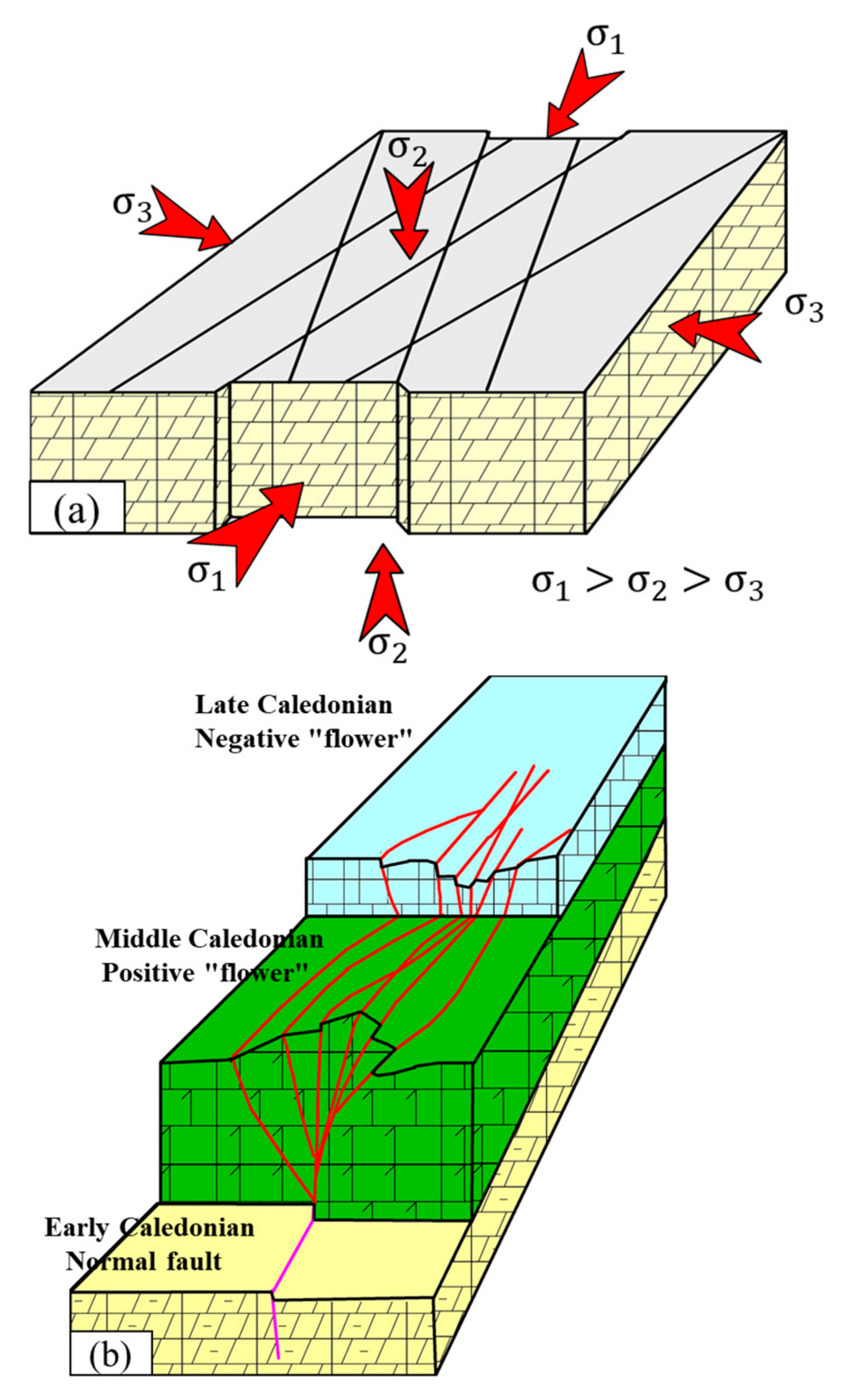
4.3.2. Formation and Evolution of Strike-Slip Faults

According to the interpretation of faults and previous data [52], the active period of Ordovician faults in the west of the Tahe area can be divided into four stages, namely, early Caledonian, mid-Caledonian to the end of early Ordovician, mid-Caledonian to the end of mid-Ordovician, and mid-Caledonian to late Ordovician. In the early Caledonian period, the northern Tarim plate and the surrounding Orogenic belt were under the unified regional dynamic background. During this period, the Tarim Basin was in a passive continental margin extension environment, the strata were relatively stable, high in the south and low in the north, and several groups of nearly EW, NW, and NE normal faults were developed (Figure 8a,e) [53,54]. At the end of the early Ordovician, the ancient Kunlun ocean began to subduct toward the Tarim plate. After the mid-Caledonian, the principal stress changes into north-south compression [30,55]. The subduction of the ancient Kunlun ocean at the end of the early Ordovician, the collision between the west Kunlun terrain and the Tarim plate, and the passive continental margin in the southwest of the Tarim plate turned into an active continental margin [56,57]. Moreover, the Tarim plate entered the compression stage, and the southwest was subjected to the NE compressive stress [58]. The NE trending extensional fault formed in the early stage was overthrust and overturned, forming the NNE trending compressional torsional strike-slip fault in the study area (Figure 8b,f). At the end of the mid-Ordovician, the southeastern Tarim plate collided with the Qaidam plate [59], and the intense Orogeny formed NW trending compressive stress, which a series of NW trending strike-slip faults (Figure 8c,g). The southwest and southeast compressive stresses caused by the subduction of the original Tethys ocean in the southern Tarim Basin are the driving force for the formation of strike-slip faults [60]. The Tahe area is affected by both the southern Tethys ocean and the northern Tianshan ocean. Under the compression stress of the southern Tianshan Ocean from north to south, the main characteristics of the three-sided compression are formed [58]. At the end of the late Ordovician, the ancient Kunlun ocean in the southwest margin of the Tarim plate closed and weakened, and the west Kunlun terrain collided strongly with the Tarim plate. During the Silurian to mid-Devonian, the ancient Altyn Tagh ocean in the southeast margin closed and collided with the Tarim plate, which resulted in the further development of NE-NW trending strike-slip faults in the previous tectonic weak zone under the southwest and southeast compressive stress (Figure 8d,h). Under the action of the thick mudstone of the upper Ordovician Sangtamu Formation, the strike-slip fault did not break through the surface, and thus formed a basement strike-slip fault, which was the negative flower shaped on the profile. During the whole mid-Caledonian period, the principal stresses of the strata are constantly changing, which is the main period for the formation of strike-slip faults. The main stress directions at each time point in the study area are shown in Figure 9. The stress direction of faults at different times is helpful in the study and identification of faults. Although the vertical distance of the strike-slip fault is small, the tensile strike-slip fault can remain open, which is conducive to the migration and accumulation of oil and gas. Therefore, in the early Caledonian, oil and gas migrated along the fault on a large scale. However, when the multi-stage principal stress changes to form a compressional torsional strike-slip, the fault is in a closed state, which is conducive to the formation of oil and gas reservoirs.

4.3.3. Genetic Mechanism Analysis of Strike-Slip Fault

According to the evolution process of strike-slip faults, the mid-Caledonian is the most important stage for the formation of strike-slip faults, and the faults developed in the later stage are the associated faults generated by the activation of strike-slip faults in the mid-Caledonian, with different mechanisms [60]. The faults in the west of Tahe area are closely related to tectonic stress. Akekule uplift, where the Tahe area is located, is affected by the multi-stage tectonic movement, and the main stress of the formation is constantly changing [61]. The basement structure in the north of the Tarim plate is uniform and flat, and brittle carbonate strata are developed. Under the joint compression of the southern Tianshan ocean, the ancient Kunlun ocean, and the ancient Altyn Tagh ocean, the “X” type conjugate strike-slip fault under the pure shear mechanism is formed [62], namely, it is a non-rotational strain and conjugate shear symmetric fracture (Figure 10a). According to the Anderson model and Coulomb fracture criterion, the direction of the maximum principal stress of the “X” type conjugate strike-slip fault is parallel to the direction of the acute bisector and consistent with the direction of the historical principal stress [58]. In the mid-Caledonian, the closed subduction of the ancient Kunlun ocean in the southwest margin and the ancient Altyn Tagh ocean in the southeast margin caused a strong compression on the Tarim plate, forming a series of NE and NW strike-slip faults. At the same time, the southern Tianshan ocean in the north exerts compressive stress from north to south, and under the joint action of tripartite stress, an “X” type conjugate shear strike-slip fault is formed in the brittle carbonate strata. At the beginning of Silurian, the ancient Kunlun ocean was completely closed, and the strike-slip fault of the seismic profile was inactive under the adjustment of the large thick mudstone of the Sangtamu Formation, which was a fault connecting the source and not connecting the sky. From late Caledonian to early Hercynian, the southern branch of the Altyn Tagh ocean was closed, which was mainly affected by the southeastern compressive stress during this period, and promotes the reactivation of the strike-slip fault formed in the mid-Caledonian (Figure 10b).

5. Discussion: Controlling Effects of Strike-Slip Faults on Migration and Aggregation of Oil and Gas Resources

5.1. Strike-Slip Fault Reconstruction Reservoir

Strike-slip faults play a significant role in the control of impacts on the distribution of oil and gas resources as well as a constructive role in the development of carbonate reservoirs [63,64,65]. Strike-slip faults have the main characteristics of high-angle oblique intersections under multi-stage tectonic movements and multi-stress changes, which would be conducive to the dissolution of atmospheric fresh water along the fault zone during the unconformity deposition period, and is conducive to the migration and dissolution of deep hydrothermal fluids. Numerous fractured-vuggy reservoirs have been formed. The fault and its fault zone improve the porosity and permeability conditions of the reservoir, especially the permeability, increase the contact area between the fluid and carbonate rock, accelerate the karst rate, and accelerate the formation of fracture-vuggy reservoir. First, the fault zone itself is a good reservoir. In the multi-stage fault activity, a large number of fault spaces with good porosity and permeability are formed near the fault zone. Second, in the multi-stage fault activity, the reservoir with poor porosity and permeability was destroyed and rebuilt again in the tectonic movement, forming the reservoir with good porosity and permeability. Third, the multi-stage tectonic uplift exposed the carbonate rock to the surface, and the fault and fault zone communicated with the surface water to provide a good channel for dissolution. In addition, the primary strike-slip fault is directly inserted into the basement, which is also a good channel for the deep hydrothermal fluid. During the flow process, the carbonate rocks are transformed again to form karst caves and dissolved reservoirs. The fracture-vuggy body with “bead-like” seismic reflection characteristics is developed along the strike-slip faults in the research area. In addition, vertical strike-slip faults are connected with dissolved vugs, and vugs and cavities are formed at the early stage, which increases the connectivity of the reservoir and becomes an effective space for oil and gas accumulation. The strata are developed and the oil and gas are enriched. The formation stress near strike-slip faults varies greatly, and faults develop considerably. Therefore, there are many high yield wells in the fault zone. Moreover, the fault zone reservoir is developed, and the fault could effectively improve the physical properties of the reservoir.

5.2. Strike-Slip Fault Provides Channels for Oil and Gas

Fault zones are the main channels for oil and gas migration and accumulation in the research area, and migration and accumulation capacities of oil and gas would vary due to fault zones with different grades and combinations. Core data from multiple wells show faults and dissolved vugs (Figure 11). Faults are densely distributed, the crack surface is filled with crude oil or asphalt, and oil seeps out after a long time. Dissolved vugs are developed and arranged along faults. This phenomenon shows that faults are channels for the multi-phase migration of oil and gas. The asphaltene charging of the fault in the core also proves that the fault is a direct channel for oil and gas migration. According to the previous analysis of the relationship between oil well production and faults [66], primary faults have high oil and gas charging efficiency and a high degree of oil and gas enrichment. The Cambrian-Ordovician source rocks can reach the reservoir through large faults. From the fault activity time and oil and gas charging time (Figure 12), in the middle and late Caledonian to the early Hercynian period, a large amount of hydrocarbon was expelled. At this time, the strong tectonic movement made the faults that were formed earlier to open again, and oil and gas migrated along the faults. In addition, there are few high yield wells in areas with undeveloped faults, especially those lacking primary faults. Most of the high yield wells are developed at the intersection of large conjugated faults in the east, and faults of different scales are distributed in a network, which form the main channels for oil and gas migration. Natural fracture networks connect the reservoirs, and oil and gas gradually accumulate in higher parts of the structure.

5.3. The Influence of Strike-Slip Faults on Reservoir Forming Stages and Processes

It has been widely recognized by scholars that the Tahe area experienced four significant stages of oil and gas charging, namely, Caledonian, Hercynian, Indosinian and Yanshanian, as well as Himalayan [67,68,69]. Oil and gas mainly come from the source rocks of the Cambrian to middle-lower Ordovician in southeast Manjiaer Sag. The Cambrian source rocks in the mid-late Caledonian to early Hercynian period discharged a large amount of hydrocarbon in the oil generation stage. Oil and gas migrated upward along the connected source rocks and accumulated in the Ordovician carbonate reservoir. In the late Hercynian period, the strong orogeny destroyed the oil and gas reservoirs, and the formation uplift reduced the hydrocarbon expulsion rate, which was only filled in local areas. The hydrocarbon generation of the Indosinian and Yanshanian, middle-lower Cambrian source rocks was weak, but some oil and gas migrated along the fault and accumulated in the Ordovician karst fractures and caves. The middle-lower Cambrian source rocks in the Himalayan platform basin generally entered the stage of high mature condensate oil and gas, and a large amount of hydrocarbon was expelled. A large amount of oil and gas migrated from southeast to northwest along the fault to the Ordovician karst fracture-cave reservoir (Figure 12).
Most of the deep and large faults in the west of Tahe have extended to the source rocks, and the vertical fracture horizons are T50–T90 (Figure 13). After multiple periods of tectonic movement and karstification, the deep and large fault system has been continuously broken and repeatedly eroded and expanded. Moreover, it was accompanied by a large number of secondary faults that have been eroded and expanded, which have become the dominant channels and storage spaces for oil and gas charging, migration, and accumulation in the later stage. The oil and gas continuously flow into the fault zone, dredge along the fault system to the farther place on the plane, and then readjust to form reservoirs relying on the fault zone (Figure 13). Under the mid-late Caledonian tectonic movement, the Cambrian-Ordovician source rock oil and gas system in the southeast Manjiar sag migrated along the deep fault to the Akekule uplift, where the Tahe oilfield is located, which forms the first large-scale oil and gas generation. In the late Hercynian period, Manjiar sag generated a large amount of hydrocarbon with sufficient oil and gas supply, and a large amount of oil and gas was injected along the strike-slip fault zone formed in the early stage. Although the strong orogenic uplift resulted in the fact that some oil and gas reservoirs were destroyed, some fractured-vuggy carbonate reservoirs remained in the slope of the uplift area. Cambrian source rocks in the Himalayan period are generally mature and enter the condensate gas stage, and Ordovician strata enter the peak of oil generation. At this time, the Tahe oilfield is dominated by gas, and oil and gas are jointly charged.

5.4. Migration and Accumulation under Fault Controlling Roles

5.4.1. Controlling Effects of Faults on the Vertical and Horizontal Distribution of Oil and Gas

The NE and NW primary strike-slip faults on the east side of the study area are conjugated shear (Figure 14a), and the strike-slip faults extend along the direction of hydrocarbon migration and accumulation on the plane. The vertical strike-slip fault zone is prone to form compressive-torsional traps under the action of compressive-torsional stress, where oil and gas accumulate and distribute in belts. The high yield wells are distributed in high positions along the NE-NW trending faults in the eastern part of the study area (Figure 14a,b). It would be worth noting that the intersections of the fault zones are rich in oil and gas, which indicates that faults connecting source rocks are rich in oil and gas. Deep hydrocarbons can migrate along faults into reservoirs. It shows that the deep and large-scale faults control the accumulation of oil and gas. In terms of the actual drilling, a large number of venting and leakage phenomena have occurred in the fault development zone, especially the connected source fault zone, indicating that the development of pores and fractures in the fault zone would be an important area of karst. Faults play a significant role in controlling the development degree, development direction, development depth, and scope of surrounding reservoirs. It can be seen from Figure 14c (residual impedance properties of the T74–T76 interval) that the karst cave development area is basically distributed along the fault. At the same time, according to the statistics of the actual drilling data in the research area, results of this study found that the ventilation and leakage intervals are characterized by “beaded” reflection in seismic, and the fractures are dense around the beaded development area (Figure 14d).

5.4.2. Oil and Gas Enrichment Law on Faults with Different Grades

Three levels of faults with different scales are developed in the research area. Results of this research showed that differences in fault activity stages, scales, and cutting horizons lead to significant differences in the oil-controlling effects of various faults. In addition, the segmentation of the same fault and the difference in structural styles applies considerable controlling impacts on the oil and gas accumulation, but the difference is significant. This research analyzed a total of 283 oil wells and the results showed that 146 oil wells were controlled in the primary fault zone, with an average cumulative oil production of 5.54 × 10⁴ t (Table 1). In addition, 137 oil wells were controlled in the secondary fault zone, with an average cumulative oil production of 2.56 × 10⁴ t. The number and average production of oil wells in the primary fault zone are significantly higher than the secondary fault zone. Moreover, the data showed that the primary fault zone controlled 27 high yield wells, with an average cumulative oil production of 19.81 × 10⁴ t, and controlled 31 medium yield wells, with an average cumulative oil production of 5.23 × 10⁴ t. Furthermore, the secondary fault zone controlled eight high yield wells, with an average cumulative oil production of 12.56 × 10⁴ t, and controlled twenty-four medium yield wells, with an average cumulative oil production of 4.18 × 10⁴ t. The number of medium and high yield wells in the primary fault zone is significantly higher than the secondary fault zone, and the average production of medium and high yield wells is higher than the secondary fault zone. In addition, low yield wells are evenly distributed in the primary and secondary fault zones, and the average cumulative production made a slight change. The comprehensive analysis of this research showed that the medium and high yield wells were mainly located in the primary and secondary fault zones, which play a decisive role on oil and gas charging. Moreover, the tertiary fault has significantly weaker controlling effects on the oil and gas than the primary and secondary fault. Furthermore, small-scale faults have a small control range and could merely change the degree of oil and gas enrichment in localized areas. In contrast, deep and large-scale faults have a wide control range and determine the range of oil and gas enrichment to a large extent. Therefore, small-scale faults control the local scope and change the oil and gas enrichment, while deep and large-scale faults control the width of hydrocarbon enrichment and determine the range of hydrocarbon enrichment effectively.
According to the comprehensive analysis of oil producing wells under different geological backgrounds in the Tahe area, the control factors of oil and gas distribution in different well areas are different in terms of three significant aspects (Figure 15 and Figure 16):
  • The primary faults are oil-rich, while the secondary and tertiary faults which are homologous to the primary faults are relatively rich in oil and gas. The oil and gas enrichment degree is higher at the intersection of faults or in the shear zone of different grades of faults. Faults are one of the significant channels for oil and gas migration in the research area. The scale and combination of faults effectively determine the efficiency of oil and gas migration.
  • The secondary and tertiary faults between the primary faults control the oil and gas, and thus its scale is relatively small and distributed independently. The oil and gas controlled by the numerous secondary and tertiary faults between the primary faults are small and scattered. This is mainly attributed to the lack of faults connecting the source rock. Oil and gas migrate and charge laterally through unconformity surfaces or fracture zones. Therefore, they are relatively low, mostly manifested as the same layer of oil and water.
  • The tertiary fault zones are sheared relatively to each other and form a network, which provides a good channel for the charging and adjustment of oil and gas in the later stage. There are many NE-NW trending faults developed in the eastern part of the research area, and they are sheared in a network structure, which provides good channels for oil and gas charging processes. The surrounding water system in this area is developed, and the overlying water system undergoes large-scale dissolution along the faults in the work area, thus forming a fracture-cavity system in different parts. As a result, the scale of the reservoir is relatively large, and the degree of oil and gas enrichment is relatively high. Moreover, the karstification is relatively weak and the degree of hydrocarbon enrichment is low in this region.
Figure 15. Average cumulative production of high, medium, and low production wells in different grades of faults. (a) Average cumulative production of high, medium, and low production wells. (b) Average cumulative production of high, medium, and low yield wells in primary and secondary faults.
Energies 16 02370 g015
Figure 16. Superposition of oil and gas production and faults of different types at the top of Yijianfang Formation (T74).
Energies 16 02370 g016
The scale of oil and gas reservoirs under the control of the primary faults is the largest, while the scale of oil and gas reservoirs under the control of the tertiary faults is relatively smaller. Numerous fractured-vuggy reservoirs have developed along the fault zone, making it an excellent reservoir, where a large number of high yield wells are located. The number of high yield wells is roughly proportional to the distance from the fault zone.

5.5. Oil and Gas Charging Model

According to the development of faults and the distribution of oil and water, results of this research show that faults are the main channels for oil and gas charging processes, and the unconformity plays a secondary or adjusting role. Therefore, the scale, combination style, and fracture depth of different faults play a crucial role in the effective migration of oil and gas. From this perspective, it is considered that there are four significant oil and gas charging models under different fault scales and combination styles in this research (Figure 17):
Model 1: Oil and gas charging model controlled by secondary faults. This model refers to secondary faults parallel to primary faults in controlling the accumulation of oil and gas (Figure 17a). It is relatively early and has the ability to transport oil and gas. The transport model controlled by this fault has the main characteristic of a high charging degree in the middle and crossed ends; however, the overall enrichment scale of oil and gas is smaller than the scale controlled by the primary fault.
Model 2: The oblique charging model of faults with different orders. This model indicates that after oil and gas migrate along the primary faults, they migrate along the low-order faults at the intersection of the secondary, tertiary fault zones and the primary faults (Figure 17b). The most common fault type is the Y-type structure. The secondary faults close to the oil source and with good connectivity have strong oil and gas migration capacity. However, the oil and gas production of the fault zone is low, which is far away from the oil source, has poor connectivity, and has no good structural location. The model is affected by many factors, and the reservoir scale is smaller than Model 1, since the fault scale is limited due to numerous factors, such as oil and gas leakage during migration or reservoir reconstruction. Therefore, the fault dredging distance is limited.
Model 3: The charging model controlled by the primary fault. This model refers to the migration of oil and gas into the reservoir along the primary fault, and is the main oil and gas charging model in the work area (Figure 17c). The primary fault zone is not only a channel for oil and gas migration, but also a storage space. The flower-shaped structural fault has a large range of reservoirs and high efficiency of oil and gas migration. This mode has a large accumulation scale and a high degree of oil and gas enrichment. Most of the high yield wells are located at this model. Moreover, the transfer efficiency of oil and gas is positively correlated with the size of fractures.
Model 4: The composite charging model of tertiary faults and unconformities. This model refers to the charging of oil and gas into the reservoir through tertiary faults and unconformity channels in areas where large faults are underdeveloped (Figure 17d). The late Hercynian period is the main period of current oil and gas accumulation in the Tahe oilfield, which is attributed to the fact that the Cambrian-Ordovician source rock in Manjiaer depression in the southeast of the Tahe oilfield is at the peak of oil generation, and the oil source is particularly rich. However, due to the shallow incision depth of the tertiary fault, the weaker transport capacity of the small scale, and of the limited transport capacity of the unconformity in the oil and gas, the oil and gas accumulation scale in this model is small, and the oil and water are mostly produced together.
Figure 17. Oil and gas charging model. (a) Secondary fault-controlled hydrocarbon charging model. (b) Oblique charging model of different grades of faults. (c) Model of oil and gas charging in the primary fault. (d) Tertiary fault and unconformity composite charging pattern.
Energies 16 02370 g017
Actual drilling of this research shows that the cumulative production of oil wells is closely related to the size of faults (Table 2), namely, the larger the fault scale, the higher the degree of hydrocarbon enrichment. Areas with underdeveloped faults generally have lower yields. The oil and gas charging efficiency of the unconformity surface is low. The average cumulative oil volume of a single well is only 5900 t. According to the statistics of the four charging models in the research area, the first three charging models are all high oil-rich models, model 3 has the highest single-well cumulative production, and the fourth type of oil and gas charging model has the lowest production.
Based on the results of this research, four charging models jointly control hydrocarbon migration and accumulation. The primary fault is a high-speed channel for oil and gas migration and accumulation, and the fracture-cave body has a high degree of oil and gas enrichment. Secondary faults and tertiary faults intersect and connect with the primary fault, which effectively improve oil and gas migration and promote oil and gas accumulation. Large-scale and early-developed secondary faults could aggregate independently due to their ability to migrate and aggregate. Since the tertiary faults developed late, the fault layer is shallow, and cannot be connected with the source rock. Moreover, the oil and gas migration capacity is limited due to the small scale.

6. Conclusions

The three-dimensional fault distribution model is applied to the fine interpretation of the faults in the Tahe area. The faults in the Tahe area are divided into primary faults, secondary faults, tertiary network faults, primary and secondary NNE and NNW strike-slip faults, with the formation of “X” type conjugate shear, which developed a grid-like fault system. The structural styles of strike-slip faults can be divided into four types, including “Single line”, “Y”, “Flower”, and “Parallel lines”. Among them, flower-shaped and Y-shaped structures are more conducive to hydrocarbon dispersion. Due to the different longitudinal stress properties, the positive flower structure style is formed by compressive stress at the top of the mid-Ordovician, and the negative flower structure style is formed by tensile stress at the top of the early Ordovician to mid-Devonian. The section is characterized by longitudinal stratification. The deep fault is high, steep, and vertical, which is mainly characterized by compression and torsion, and the shallow part is mainly characterized by tension and torsion. There are two combinations of deep faults. “Lower single branch-upper flower type” and “lower single branch-upper single branch type”. The seismic profile of the “lower single branch-upper flower type” fault shows that the main fault cuts down the base, while the middle and upper Ordovician are “flower-like” patterns. The main trunk of the “lower single branch-upper single branch type” fault cuts down the base, and the upper part is in a single branch shape.
The active period of Ordovician faults in the western Tahe area can be divided into four stages, namely, early Ordovician, post-early Ordovician, post-mid-Ordovician, and late Ordovician. The “X” type conjugate strike-slip fault was formed by many tectonic movements, such as north-south extension, northwest compression, and northeast compression, which led to a network pattern of strike-slip faults in the Tahe area.
Strike-slip faults can not only transform carbonate reservoirs, but also play significant roles in forming oil and gas migration channels, and in providing shielding for reservoirs. Strike-slip faults control the horizontal and vertical distribution of oil and gas, and the “X” conjugate shear zone is the most favorable place for oil and gas accumulation. Fault grade is the key factor to control oil and gas migration efficiency and reservoir scale. The larger the fault level, the more conducive it would be to oil and gas migration and accumulation. In the Tahe oilfield, there are four charging models related to strike-slip faults. Among them, the oil and gas migration efficiency of the filling model related to the primary main fault is higher, and the high yield wells are mostly distributed.

Author Contributions

Conceptualization, R.Y. and Z.S.; methodology, F.G.; software, L.W. (Li Wang); validation, Z.S. and L.W. (Lingda Wang); formal analysis, L.W. (Li Wang); investigation, J.G.; resources, F.G.; data curation, L.W. (Lingda Wang); writing—original draft preparation, Z.S.; writing—review and editing, R.Y.; visualization, J.G.; supervision, F.G.; project administration, R.Y. All authors have read and agreed to the published version of the manuscript.

Funding

This research received no external funding.

Institutional Review Board Statement

Not applicable.

Informed Consent Statement

The study did not involve humans.

Data Availability Statement

Not applicable.

Acknowledgments

We appreciate the support and assistance of the Petroleum Exploration and Production Research Institute of Northwest Oilfield Company Sinopec during the process of data collection and data analysis. The authors also express their sincere thanks for the valuable suggestions and useful comments from the reviewers and executive editor.

Conflicts of Interest

The authors declare no conflict of interest.

References

  1. Duan, T.Z.; Zhang, W.B.; Lu, X.B.; Li, M.; Zhao, H.W.; Shang, X.F. Architectural characterization of Ordovician fault-controlled paleokarst carbonate reservoirs, Tahe oilfield, China. Interpretation 2020, 8, T953–T965. [Google Scholar] [CrossRef]
  2. Méndez, J.N.; Jin, Q.; González, M.; Zhang, X.; Lobo, C.; Boateng, C.D.; Zambrano, M. Fracture characterization and modeling of karsted carbonate reservoirs: A case study in Tahe oilfield, Tarim Basin (western China). Mar. Pet. Geol. 2020, 112, 104104. [Google Scholar] [CrossRef]
  3. Wu, G.H.; Yang, H.J.; Qu, T.L.; Li, H.W.; Luo, C.S.; Li, B.L. The fault system characteristics and its controlling roles on marine carbonate hydrocarbon in the Central uplift, Tarim basin. Acta Petrol. Sin. 2012, 28, 793–805. [Google Scholar]
  4. Ma, Q.Y.; Cao, Z.C.; Jiang, H.S.; Lan, M.J. Source-connectivity of strike slip fault zone and its relationship with oil and gas accumulation in Tahe-Shunbei area, Tarim Basin. Mar. Ori. Pet. Geol. 2020, 25, 327–334. [Google Scholar] [CrossRef]
  5. Zhao, R.; Deng, S.; Yun, L.; Lin, H.X.; Zhao, T.; Yu, C.; Kong, Q.F.; Wang, Q.; Li, H.L. Description of the reservoir along strike-slip fault zones in China T-Sh oilfield, Tarim Basin. Carbonates Evaporites 2021, 36, 1. [Google Scholar] [CrossRef]
  6. Han, C.C.; Lin, C.Y.; Lu, X.B.; Tian, J.J.; Ren, L.H.; Ma, C.F. Petrological and geochemical constraints on fluid types and formation mechanisms of the Ordovician carbonate reservoirs in Tahe Oilfield, Tarim Basin, NW China. J. Pet. Sci. Eng. 2019, 178, 106–120. [Google Scholar] [CrossRef]
  7. Tian, F.; Jin, Q.; Lu, X.B.; Lei, Y.H.; Zhang, L.K.; Zheng, S.Q.; Zhang, H.F.; Rong, Y.S.; Liu, N.G. Multi-layered Ordovician paleokarst reservoir detection and spatial delineation: A case study in the Tahe Oilfield, Tarim Basin, Western China. Mar. Pet. Geol. 2016, 69, 53–73. [Google Scholar] [CrossRef]
  8. Shi, J.X. Study on Controlling Effects of Faults and Fractures on Ordovician Carbonate Fracture-Cavity Bodies in Tahe Oilfield; China University of Petroleum: Beijing, China, 2020. [Google Scholar]
  9. Lue, X.X.; Yang, N.; Zhou, X.Y.; Yang, H.J.; Li, J.J. Influence of Ordovician carbonate reservoir beds in Tarim Basin by faulting. Sci. China Ser. D Earth Sci. 2008, 51, 53–60. [Google Scholar] [CrossRef]
  10. Ning, F.; Lin, H.X.; Zhou, C.J.; Yun, J.B.; Li, P.; Song, H.M. Characteristics of strike-slip fault-related reservoirs and the significance for hydrocarbon accumulation in the central Tarim Basin: Insights from the modern karst model. Front. Earth Sci. 2022, 10, 987020. [Google Scholar] [CrossRef]
  11. Wang, R.J.; Yang, J.P.; Chang, L.J.; Zhang, Y.T.; Sun, C.; Wan, X.G.; Wu, G.H.; Bai, B.C. 3D Modeling of Fracture-Cave Reservoir from a Strike-Slip Fault-Controlled Carbonate Oilfield in Northwestern China. Energies 2022, 15, 6415. [Google Scholar] [CrossRef]
  12. Lv, Y.P.; Ma, H.L.; Wang, Z.; Deng, G.X.; Wen, H. Genetic Types of the tp12cx Strike-Slip Fault Segments and Their Role in Controlling Reservoirs in the Tarim Basin. Front. Earth Sci. 2022, 10, 916475. [Google Scholar] [CrossRef]
  13. Zhang, W.B.; He, Z.L.; Duan, T.Z.; Li, M.; Zhao, H.W. Hierarchical Modeling of Carbonate Fault-Controlled Paleokarst Systems: A Case Study of the Ordovician Reservoir in the Tahe Oilfield, Tarim Basin. Front. Earth Sci. 2022, 10, 840661. [Google Scholar] [CrossRef]
  14. Zhang, S.; Jin, Q.; Sun, J.F.; Wei, H.H.; Cheng, F.Q.; Zhang, X.D. Formation of hoodoo-upland on Ordovician karst slope and its significance in petroleum geology in Tahe area, Tarim Basin, NW China. Pet. Explor. Dev. 2021, 48, 354–366. [Google Scholar] [CrossRef]
  15. Zhang, W.B.; Duan, T.Z.; Li, M.; Zhao, H.W.; Shang, X.F.; Wang, Y. Architecture characterization of Ordovician fault-controlled paleokarst carbonate reservoirs in Tuoputai, Tahe oilfield, Tarim Basin, NW China. Pet. Explor. Dev. 2021, 48, 367–380. [Google Scholar] [CrossRef]
  16. Wang, Q.H.; Zhang, Y.T.; Xie, Z.; Zhao, Y.W.; Zhang, C.; Sun, C.; Wu, G.H. The Advancement and Challenges of Seismic Techniques for Ultra-Deep Carbonate Reservoir Exploitation in the Tarim Basin of Northwestern China. Energies 2022, 15, 7653. [Google Scholar] [CrossRef]
  17. Neng, Y.; Li, Y.; Qi, J.F.; Ma, X.; Zuo, L.; Chen, P. Deformation Styles and Multi-Stage Evolution History of a Large Intraplate Strike-Slip Fault System in a Paleozoic Superimposed Basin: A Case Study From the Tarim Basin, NW China. Front. Earth Sci. 2022, 10, 837354. [Google Scholar] [CrossRef]
  18. Wu, G.H.; Yuan, Y.J.; Huang, S.Y.; Vandyk, T.M.; Xiao, Y.; Cai, Q.; Luo, B.X. The Dihedral Angle and Intersection Processes of a Conjugate Strike-Slip Fault System in the Tarim Basin, NW China. Acta Geol. Sin. Engl. Ed. 2018, 92, 74–88. [Google Scholar] [CrossRef]
  19. Zhao, T.; Zhang, J.B.A.; Ding, W.L.; Zhao, R.; Radwan, A.E.; Wang, X.H. Characteristics and application of present in situ stress field of a strike-slip fault: A 3D finite-element simulation study. Geol. Mag. 2022, 159, 1–18. [Google Scholar] [CrossRef]
  20. Zhu, Y.F.; Zhang, Y.T.; Zhao, X.X.; Xie, Z.; Wu, G.H.; Li, T.; Yang, S.; Kang, P.F. The Fault Effects on the Oil Migration in the Ultra-Deep Fuman Oilfield of the Tarim Basin, NW China. Energies 2022, 15, 5789. [Google Scholar] [CrossRef]
  21. Zhang, S.C.; Gao, Z.Y.; Li, J.J.; Zhang, B.M.; Gu, Q.Y.; Lu, Y.H. Identification and distribution of marine hydrocarbon source rocks in the Ordovician and Cambrian of the Tarim Basin. Pet. Explor. Dev. 2012, 39, 305–314. [Google Scholar] [CrossRef]
  22. Teng, C.Y.; Cai, Z.X.; Hao, F.; Cao, Z.C. Structural geometry and evolution of an intracratonic strike-slip fault zone: A case study from the north SB5 fault zone in the Tarim Basin, China. J. Struct. Geol. 2020, 140, 104159. [Google Scholar] [CrossRef]
  23. Lan, X.D.; Lv, X.X.; Zhu, Y.M.; Yu, H.D. The geometry and origin of strike-slip faults cutting the Tazhong low rise megaanticline (central uplift, Tarim Basin, China) and their control on hydrocarbon distribution in carbonate reservoirs. J. Nat. Gas Sci. Eng. 2015, 22, 633–645. [Google Scholar] [CrossRef]
  24. Tian, F.; Di, Q.Y.; Jin, Q.; Cheng, F.Q.; Zhang, W.; Lin, L.M.; Wang, Y.; Yang, D.B.; Niu, C.K.; Li, Y.X. Multiscale geological-geophysical characterization of the epigenic origin and deeply buried paleokarst system in Tahe Oilfield, Tarim Basin. Mar. Pet. Geol. 2019, 102, 16–32. [Google Scholar] [CrossRef]
  25. Zhang, K.; Wang, D.R. Types of karst-fractured and porous reservoirs in China's carbonates and the nature of the Tahe Oilfield in the Tarim Basin. In Proceedings of the 32nd International Geological Congress on Geology of China, Florence, Italy, 20–28 August 2004. [Google Scholar]
  26. Liu, J.H.; Ding, W.L.; Yang, H.M.; Wang, R.Y.; Yin, S.; Li, A.; Fu, F.Q. 3D geomechanical modeling and numerical simulation of in-situ stress fields in shale reservoirs: A case study of the lower Cambrian Niutitang formation in the Cen'gong block, South China. Tectonophysics 2017, 712, 663–683. [Google Scholar] [CrossRef]
  27. Zhan, Z.W.; Zou, Y.R.; Pan, C.C.; Sun, J.N.; Lin, X.H.; Peng, P.A. Origin, charging, and mixing of crude oils in the Tahe oilfield, Tarim Basin, China. Org. Geochem. 2017, 108, 18–29. [Google Scholar] [CrossRef]
  28. Wu, J.; Fan, T.L.; Gao, Z.Q.; Yin, X.X.; Fan, X.; Li, C.C.; Yu, W.Y.; Li, C.; Zhang, C.J.; Zhang, J.H.; et al. A conceptual model to investigate the impact of diagenesis and residual bitumen on the characteristics of Ordovician carbonate cap rock from Tarim Basin, China. J. Pet. Sci. Eng. 2018, 168, 226–245. [Google Scholar] [CrossRef]
  29. Zhou, W.; Li, X.H.; Jin, W.H.; Zhao, Z.C.; Zhou, Q.M. The control action of fault to paleokarst in view of Ordovician reservoir in Tahe area. Acta Petrol. Sin. 2011, 27, 2339–2348. [Google Scholar]
  30. Hu, H. Western Tahe Oilfield Fracture Characteristics and the Relationship of Oil and Gas Research. Master’s Thesis, Chengdu University of Technology, Chengdu, China, 2013. [Google Scholar]
  31. Yang, Z.H.; Zhang, N.; Dong, J.X.; Xia, W.C.; Bao, Z.Y. Carbon Oxygen Isotope Analysis and Its Significance of Carbonate in the Zhaogezhuang Section of Early Ordovician in Tangshan, North China. J. Earth Sci. 2013, 24, 918–934. [Google Scholar] [CrossRef]
  32. Liu, Y.M.; Hou, J.G.; Li, Y.Q.; Dong, Y.; Ma, X.Q.; Wang, X.X. Characterization of Architectural Elements of Ordovician Fractured-cavernous Carbonate Reservoirs, Tahe Oilfield, China. J. Geol. Soc. India 2018, 91, 315–322. [Google Scholar] [CrossRef]
  33. Yu, R.L.; Fu, H. Influence of Tectonic Movement on Ordovician Carbonates of Tahe Oilfield. Nat. Gas. Explor. Dev. 2006, 29, 1–6. [Google Scholar] [CrossRef]
  34. Li, Y.Q.; Hou, J.G.; Ma, X.Q. Data integration in characterizing a fracture-cavity reservoir, Tahe oilfield, Tarim basin, China. Arabian J. Geosci. 2016, 9, 532. [Google Scholar] [CrossRef]
  35. Cai, X.Y.; Wang, Y. The formation and distribution of the marine hydrocarbon source rock in the Tarim basin, NW China. Acta Geol. Sin. Engl. Ed. 2008, 82, 509–519. [Google Scholar] [CrossRef]
  36. Liu, D.H.; Xiao, X.M.; Mi, J.K.; Li, X.Q.; Shen, J.K.; Song, Z.G.; Peng, P.A. Determination of trapping pressure and temperature of petroleum inclusions using PVT simulation software-a case study of Lower Ordovician carbonates from the Lunnan Low Uplift, Tarim Basin. Mar. Pet. Geol. 2003, 20, 29–43. [Google Scholar] [CrossRef]
  37. Lv, H.T.; Ding, Y.; Geng, F. Hydrocarbon accumulation patterns and favorable exploration areas of the Ordovician in Tarim Basin. Oil Gas Geol. 2014, 35, 798–805. [Google Scholar] [CrossRef]
  38. Liu, H.Q.; Qiu, C.N.; Tang, H.; Sima, L.Q.; Zhao, J. Study on the Fracture Distribution and Numerical Simulation of Ordovician Carbonate Reservoir in Block 12 of Tahe Oilfield. Acta Sediment. Sin. 2011, 29, 1079–1085. [Google Scholar] [CrossRef]
  39. Tang, H.; Xie, L.; Su, B.; Han, T. Fracture and vug character of Ordovician carbonate reservoir in Tazhong Oilfield. Zhongguo Shiyou Daxue Xuebao (Ziran Kexue Ban) 2013, 27, 7–13. [Google Scholar] [CrossRef]
  40. Ji, X.F.; Zhao, X.K.; Fu, J.X.; Li, K.; Dai, H.S.; Zeng, W.C.; Tong, C. The relationship of fault character and oil-gas accumulation in Akekule lobe of north Tarim. Comput. Tech. Geophys. Geochem. Explor. 2008, 30, 394–399. [Google Scholar] [CrossRef]
  41. Fu, Q.; Ye, M.L. Source Rock Depositional Evolution in Caohu Sag-Kuerle Nose Salient, Tarim Basin. J. Tongji Univ. (Nat. Sci.) 2005, 33, 535–539. [Google Scholar] [CrossRef]
  42. Zhu, H.; Meng, W.B.; Zeng, H.Y.; Yang, Y.J. Characteristics and controlling factors of Ordovician carbonate reservoir in Tuofutai area. Lithol. Reserviors 2010, 22, 54–59. [Google Scholar] [CrossRef]
  43. Fan, Y.; He, X.M.; Wang, Y.; Cao, T.S.; Dan, Y. The Characteristics of Fluid Inclusion and Oil and Gas Accumulation of Ordovician in Main area, Tahe Oilfield. XinJiang Geol. 2013, 31, 116–121. [Google Scholar]
  44. Wu, Y. The Coupling Relationship between Differential Structural Evolution and Hydrocarbon Charging History in the Ordovician of Tahe Oilfield, Tarim Basin. Ph.D. Thesis, China University of Geosciences (Wuhan), Wuhan, China, 2013. [Google Scholar]
  45. Zhang, T. The Study on the formation and Preservation of Karstic Reservoir of Ordovician in Akekule Uplift, Tarim Basin. Ph.D. Thesis, China University of Geosciences (Beijing), Beijing, China, 2012. [Google Scholar]
  46. Yun, L. Petroleum of Ordovician Accumulation Model Reservoir in Tahe Oilfield. Ph.D. Thesis, China University of Geosciences (Beijing), Beijing, China, 2009. [Google Scholar]
  47. Li, K. Study on Structural Characteristics and Hydrocarbon Potential of Akkule Uplift. Master’s Thesis, Chengdu University of Technology, Chengdu, China, 2006. [Google Scholar]
  48. Deng, S.; Li, H.L.; Zhang, Z.P.; Zhang, J.B.; Yang, X. Structural characterization of intracratonic strike-slip faults in the central Tarim Basin. AAPG Bull. 2019, 103, 109–137. [Google Scholar] [CrossRef]
  49. Ding, Z.W.; Wang, R.J.; Chen, F.F.; Yang, J.P.; Zhu, Z.Q.; Yang, Z.M.; Sun, X.H.; Xian, B.; Li, E.P.; Shi, T.; et al. Origin, hydrocarbon accumulation and oil-gas enrichment of fault-karst carbonate reservoirs: A case study of Ordovician carbonate reservoirs in South Tahe area of Halahatang oilfield, Tarim Basin. Pet. Explor. Dev. 2020, 47, 306–317. [Google Scholar] [CrossRef]
  50. Tang, H.Z.; Xu, Y.Z.; Liu, Y.F.; Fan, Q.H.; Zhang, K.; Sun, Q. Application of multiple-attribute analysis in fractures and cracks of HLHT area. Chin. Min. Mag. 2013, 22, 51–53. [Google Scholar] [CrossRef]
  51. Wu, G.H.; Ma, B.S.; Han, J.F.; Guan, B.Z.; Chen, X.; Yang, P.; Xie, Z. Origin and growth mechanisms of strike-slip faults in the central Tarim cratonic basin, NW China. Pet. Explor. Dev. 2021, 48, 595–607. [Google Scholar] [CrossRef]
  52. Feng, Y.F. The Control Action of Tectonic Evolution over Oil and Gas in Akekule Lobe of Tarim Basin. Master’s Thesis, Chengdu University of Technology, Chengdu, China, 2012. [Google Scholar]
  53. Wang, Y.Y.; Chen, J.F.; Pang, X.Q.; Wang, G.; Hu, T.; Zhang, B.S.; Huo, Z.P.; Chen, H.Y. Hydrocarbon migration along fault intersection zone A case study on Ordovician carbonate reservoirs in Tazhong area, Tarim Basin, NW China. Geol. J. 2017, 52, 832–850. [Google Scholar] [CrossRef]
  54. Liu, Y. A Research on the Relationship of Oil-Gas and the Ancient Structure Evolution in Akekule Area. Master’s Thesis, Chengdu University of Technology, Chengdu, China, 2010. [Google Scholar]
  55. Ma, Q.Y.; Cao, Z.C.; Lv, H.T.; Sha, X.G. Fault Styles and the Control on Hydrocarbon Accumulation in South Slope of Central Uplift Belt, Tarim Basin. Mar. Ori. Pet. Geol. 2013, 18, 1–11. [Google Scholar] [CrossRef]
  56. Xu, Z.Q.; Li, S.T.; Zhang, J.X.; Yang, J.S.; He, B.Z.; Li, H.B.; Lin, C.S.; Cai, Z.H. Paleo-Asian and Tethyan tectonic systems with docking the Tarim block. Acta Petrol. Sin. 2011, 27, 1–22. [Google Scholar]
  57. Zhang, Q.C.; Wu, Z.H.; Chen, X.H.; Zhou, Q.; Shen, N.P. Proto-Tethys oceanic slab break-off: Insights from early Paleozoic magmatic diversity in the West Kunlun Orogen, NW Tibetan Plateau. Lithos 2019, 346, 105147. [Google Scholar] [CrossRef]
  58. Li, G.H.; Li, S.Y.; Li, H.Y.; Sun, C.; Xie, Z.; Li, F. Distribution pattern and formation mechanism of the strike-slip fault system in the central Tarim Basin. Natur. Gas Ind. 2021, 41, 30–37. [Google Scholar] [CrossRef]
  59. Dong, Y.P.; He, D.F.; Sun, S.S.; Liu, X.M.; Zhou, X.H.; Zhang, F.F.; Yang, Z.; Cheng, B.; Zhao, G.C.; Li, J.H. Subduction and accretionary tectonics of the East Kunlun orogen, western segment of the Central China Orogenic System. Earth Sci. Rev. 2018, 186, 231–261. [Google Scholar] [CrossRef]
  60. Jia, C.Z.; Ma, D.B.; Yuan, J.Y.; Wei, G.Q.; Yang, M.; Yan, L.; Tian, F.L.; Jiang, L. Structural characteristics, formation & evolution strike-slip faults in the Tarim and genetic mechanisms of Basin. Natur. Gas Ind. 2021, 41, 81–91. [Google Scholar] [CrossRef]
  61. Li, K.; Zhao, X.K.; Zhang, X.B.; Ye, B. Hydrocarbon migration pathway system types and evolution in the Akekule Rise, Tarim Basin. Chin. J. Geol. 2007, 42, 766–778. [Google Scholar] [CrossRef]
  62. Lv, H.T.; Zhang, S.N.; Ma, Q. Classification and formation mechanism of fault systems in the central and northern Tarim Basin. Pet. Geol. Exp. 2017, 4, 444–452. [Google Scholar] [CrossRef]
  63. Zhang, Z.P.; Wang, Y.; Yun, J.B.; Zhou, B.; Zhao, Z.H.; Zheng, M.L. Control of faults at different evolution stages on hydrocarbon accumulation in Tazhong area, the Tarim Basin. Oil Gas Geol. 2009, 30, 316–323. [Google Scholar] [CrossRef]
  64. Zhu, G.Y.; Zhang, Y.C.; Wang, H.H.; Yang, H.J.; Meng, S.C.; Gu, Q.Y.; Zhang, B.; Su, J. The formation and distribution of deep weathering crust in north Tarim basin. Acta Petrol. Sin. 2009, 25, 2384–2398. [Google Scholar]
  65. Kang, Y.Z. Reservoir Rock Characteristics Paleozoic Marine Facies Carbonate in The Tarim Basin. Pet. Geol. Exp. 2007, 29, 217–223. [Google Scholar] [CrossRef]
  66. Lu, X.B.; Wang, Y.; Tian, F.; Li, X.H.; Yang, D.B.; Li, T.; Lv, Y.P.; He, X.M. New insights into the carbonate karstic fault system and reservoir formation in the Southern Tahe area of the Tarim Basin. Mar. Pet. Geol. 2017, 86, 587–605. [Google Scholar] [CrossRef]
  67. Xu, H.; Guo, X.W.; Cao, Z.C.; Wang, B.; Liu, Y.L.; Chen, J.X.; Zhang, X.Y.; Luo, T. Application of Minimum Homogenization Temperatures of Aqueous Inclusions in Calcite Veins to Determine Time of Hydrocarbon Accumulation in Ordovician of Tahe Oilfield: Evidence from In-Situ Calcite U-Pb Dating by Laser Ablation. Earth Sci. 2021, 46, 3535–3548. [Google Scholar]
  68. Lv, H.T.; Zhang, W.B.; Zhang, D.J.; Lin, Z.M.; Zhao, X.K.; Li, K. Study of the evolution process of the Ordovician oil reservoir in the Tahe Oilfield, the Tarim Basin. Pet. Geol. Exp. 2008, 30, 547–556. [Google Scholar] [CrossRef]
  69. Wang, Y.; Zhang, S.N.; Liu, Y.L. Controls of strike-slip fault activities on hydrocarbon accumulation in Tahe Oilfield, Tarim Basin a case study of TP 39 fault zone. Pet. Geol. Exp. 2022, 44, 394–401. [Google Scholar] [CrossRef]
Figure 1. Index and tectonic unit map of the study area. (a) Location of the Tarim Basin. (b) Distribution of Ordovician oil and gas fields (reservoirs) and division of marine oil and gas systems in the Tarim Basin; (c) in the Cambrian-Ordovician Oil and Gas System of Awati and Manjiaer; the red-filled area is the location of the Tahe oilfield (modified from [37]). (c) Location and structure map of the northern tectonic unit in the Tarim Basin, NW China.
Energies 16 02370 g001
Figure 2. (a) Cross-section showing regional structure and stratigraphy (drawn from actual seismic cross-section; section location is shown in the right corner of (a) as the “red line”). (b) Stratigraphic column of the Paleozoic Ordovician stratigraphic units, lithology, and seismic horizons in the Tahe area of the Tarim Basin.
Energies 16 02370 g002
Figure 3. (a) Uninterpreted coherent slice of T74. (b) Fault interpretation on the coherent slice of T74. (c) Section 10 is used as an example to illustrate the interpretation process.
Energies 16 02370 g003
Figure 4. Fault interpretations. (a) Top surface coherence of Ordovician Yijianfang Formation in western Tahe. (b) Fault polygon of Ordovician Yijianfang Formation. (c) Trace direction of strike-slip faults limited to the seismic reflection window of 3500–4500 ms. Faults are shown in black and orange lines. The thick line shows the primary strike-slip faults and the thin line shows the secondary strike-slip faults (the Santamu Formation in the east is denuded and only remains in the west).
Energies 16 02370 g004
Figure 5. Rose diagram of fault strike. (a) Region-wide strike-slip rose diagram. (b) The primary strike-slip rose diagram. (c) The secondary rose strike-slip diagram. (d) Tertiary fault rose diagram.
Energies 16 02370 g005
Figure 6. Seismic profile of different strike-slip fault structure styles in the Tahe area, the thick line shows the primary strike-slip faults and the thin line shows the secondary strike-slip faults (the map position is shown in Figure 4b).
Energies 16 02370 g006
Figure 7. Seismic profile of strike-slip fault structure styles; the thick line shows the primary strike-slip faults and the thin line shows the secondary strike-slip faults (T70 is the boundary between shallow and deep. The deep is divided into two parts by Penglaiba Formation). The map position is shown in Figure 4a.
Energies 16 02370 g007
Figure 8. Evolution model of fault system in the west of the Tahe oilfield. (a,e) represent the early Caledonian (Cambrian-early Ordovician) fault system model. (b,f) represent the mid-Caledonian (mid-Ordovician) fault system model. (c,g) represent the mid-Caledonian (late Ordovician) fault system model. (d,h) represent the late Caledonian Hercynian fault system model.
Energies 16 02370 g008
Figure 9. Tectonic evolution model for the Tarim Basin. (a) Tectonic evolution in the southwestern Tarim Basin. (b) Tectonic evolution in the southeastern Tarim Basin. (c) Tectonic evolution in the northern Tarim Basin. (d) Principal stress around the Tarim Basin. TP, Tarim plate; AAO, ancient Altyn ocean; AP, Altyn plate; OB, orogenic belt; AKO, ancient Kunlun ocean; WKB, west Kunlun terrain; PTO, Paleotethys ocean; KOB, Kunlun orogenic belt; CTT, central Tianshan terrain; ASTO, ancient southern Tianshan ocean; TPYCTT, Tarim plate-Yili-central Tianshan plate.
Energies 16 02370 g009
Figure 10. Formation mechanism pattern of strike-slip fault (modified from [58]). (a) Stress pattern of strike-slip fault. (b) Fault pattern in different periods (modified from [62]).
Energies 16 02370 g010
Figure 11. Core picture. (a) Well AD2, 6292.41–6292.56 m, gray marlstone, fault and dissolved vugs, and brown crude oil seeps out along the faults for a long time. (b) Well TP31, 6508.39–6508.54 m, yellow-gray asphaltene argillaceous limestone, and faults filled with black asphalt. (c) Well AD5, 6281.42–6261.68 m, brown-gray bioclastic micritic arenaceous limestone, with many dissolved vugs; several small vugs connect to form a cavity and is partially filled with calcite. (d) Well AD12, 6444.03–6444.23 m, yellow-gray oil spotted micrite limestone and brown crude oil seeps out along the fault for a long time. (e) Well AD2, 6290.14–6290.31 m, gray-green marlstone, developed faults, and crude oil seepage. (f) Well AD7, 6348.23–6348.44 m, gray micrite limestone, one fault, and brown crude oil on crack surface.
Energies 16 02370 g011
Figure 12. Relationship between burial history and oil and gas charging model in the Tahe area.
Energies 16 02370 g012
Figure 13. Ordovician hydrocarbon migration model in the Tahe area (the model is from Figure 4c).
Energies 16 02370 g013
Figure 14. Relationship between faults and oil and gas. (a) Well distribution versus faults of T76 (top surface of Yingshan Formation), a larger radius of the pie chart represents a higher cumulative yield. (b) T74-T76 (Yingshan Formation) residual impedance and fault superposition diagram (dark blue dot indicates vugs). (c) T76 (top interface of Yingshan Formation) depth structure map. (d) Seismic section of well-1 and well-2 (well-1 is a medium yield well, and well-2 is a high yield well) distributed near the faults. (e) Map position of (ac) (red rectangle).
Energies 16 02370 g014
Table 1. Comparison of different grade faults and oil wells.
Fault TypesHigh Yield WellsAverage Oil Production
(×104)
Medium Yield WellsAverage Oil Production
(×104)
Low Yield WellsAverage Oil Production
(×104)
Total Average
Oil (×104)
Primary fault2719.81315.23881.285.54
Secondary fault812.65244.181051.422.56
Total3518.16554.771931.364.10
Table 2. Statistical elements of four charging models.
TypeFault GradeLength (km)Distance (m)DepthAverage Accumulated Oil of Single Well (104 t)
Model 1Secondary fault3.125–35Cambrian Formation5.2
Model 2Secondary and Tertiary fault5.920–30Penglaiba Formation2.9
Model 3Primary fault10.635–45Lower Cambrian Formation6.8
Model 4Tertiary fault1.810–20Yingshan Formation0.7
0.30–10Yingshan Formation0.1
Disclaimer/Publisher’s Note: The statements, opinions and data contained in all publications are solely those of the individual author(s) and contributor(s) and not of MDPI and/or the editor(s). MDPI and/or the editor(s) disclaim responsibility for any injury to people or property resulting from any ideas, methods, instructions or products referred to in the content.

