Article

Temperature Variations in Deep Thermal Well LZT-1 in Lądek-Zdrój (Bohemian Massif; SW Poland)—Evidence of Geothermal Anomaly and Paleoclimatic Changes

by
Barbara Kiełczawa
1,*,
Wojciech Ciężkowski
1,
Mirosław Wąsik
2,
Karolina Szostak
1,
Iwona Sieniawska
3 and
Marek Rasała
4
1
Department of Mining, Faculty of Geoengineering, Mining and Geology, Wroclaw University of Science and Technology, 50-370 Wrocław, Poland
2
Institute of Geological Science, Faculty of Earth Sciences and Environmental Management, University of Wroclaw, 50-205 Wrocław, Poland
3
Polish Geological Institute—National Research Institute, 00-975 Warsaw, Poland
4
Hydro-Geo-Term, 61-606 Poznań, Poland
*
Author to whom correspondence should be addressed.
Energies 2024, 17(14), 3362; https://doi.org/10.3390/en17143362 (registering DOI)
Submission received: 29 May 2024 / Revised: 28 June 2024 / Accepted: 6 July 2024 / Published: 9 July 2024
(This article belongs to the Section H: Geo-Energy)

Abstract

:
The thermal water deposit in Lądek-Zdrój (SW Poland) occurs in fractured reservoir rocks, and its hydrogeological regime is controlled by the features of the local geology and lithology of the hosting crystalline complexes, mainly impermeable high-grade metamorphosed mica schists and gneisses. The fractured thermal water aquifer is confined by a thrust fault-type aquitard that creates artesian pressure and, therefore, the water intakes and natural springs in Lądek Zdrój provide spontaneous outflow. Classical geothermometers yield an estimation of reservoir temperatures that ranges from 50 to 70 °C, with a maximum of 88 °C. The heat flux (HF) value of the Lądek-Zdrój region is 64 mW/m2. The new borehole, LZT-1, is in the border zone of a local thermal anomaly with a geothermal degree of 25–27 m/°C. The estimated temperature at the bottom of the LZT-1 borehole, under thermal equilibrium conditions, ranges between 70 °C and 80 °C. A stream of heated waters from the deep system flows from the recharge areas, shaping the local geothermal anomaly and thus influencing the thermal conditions in the Lądek-Zdrój area. The activation of this water circulation system occurred in the Pleistocene.

1. Introduction

The impact of climate change on the distribution of temperatures in the near-surface levels of the Earth’s crust has been analyzed since the 1930s, coinciding with the onset of heat flux studies [1,2]. Up to a depth of a few kilometers, the temperature variability is primarily dependent on the magnitude of the heat flux reflecting the processes taking place in the Earth’s interior. As the heat flux is described by the diffusion equation, its values also depend on climatic conditions [3,4]. In the near-surface levels of a rock massif, local climatic changes at the Earth’s surface influence the temperature [5,6]. Due to the slow rate of propagation of the thermal energy in rocks, the depth to which paleoclimatic changes occur is determined mainly by the Earth’s surface temperature during successive glaciation and subsequent warming periods, as well as their duration [4,5,7,8].
The influence of glaciation on temperature profiles in deep boreholes has been analyzed in detail in Germany, Czechia, and Slovenia [9,10], as well as in Karelia [11,12], the Urals [1,8,13], and in Poland [5,14,15,16,17,18,19,20,21,22]. Golovanova et al. [1,13], while studying the thermal conditions of the Urals, observed that the greatest disturbances of the thermal conditions of the rock mass, manifested by the decrease in the geothermal gradient and heat flow, occur to a depth of 1–1.5 km below the ground surface. They also showed that the inclusion of paleoclimatic correction in determining the adjusted value of heat flow makes it possible to calculate more reliable temperatures of deep systems and reduce the dependence of the measured temperatures on depth. A study by ref. [9] showed that the thermally significant influence of advective heat transport on the profiling results in deep boreholes in Czechia and Germany is observed to a depth of about 100 m below the ground surface, whereas paleoclimatic disturbances are reported to a depth of up to 4 km. According to ref. [12], these depths are 400 m and ca. 2 km below ground surface level, respectively. Ref. [23] developed a correction for temperatures measured at the bottom of a borehole and the depth of a temperature equilibrium disturbed by circulation of mud during drilling. In ref. [19], considering the paleotemperatures during the last glaciation (Weichselian glaciation) and the thermal equilibrium conditions of the boreholes, it was concluded that the heat flux values estimated based on data from boreholes with depths of 1–2 km are overestimated.
The influence of paleoclimatic conditions on the variability in heat flux distribution in Europe and Poland has been studied by, e.g., refs. [2,15,24,25,26]. Ref. [27] presents updated heat flux maps for the area of Poland in the context of thermal conditions in Europe and the major tectonic structures in the relevant part of the continent.
The distribution of temperatures currently observed in a deep well is the resultant value of the temperatures under conditions of thermal stability in the well (stationary geothermal conditions) and the paleoclimatic component that pervades the rock medium with suppression dependent on the diffusion properties of the rock and the delay in time [2,5]. Clauser et al. [9] and Clauser [28] believe that the borehole “warm-up” time should be at least as long as the drilling work. A similar opinion has been expressed by refs. [15] and [6], who have also pointed out that in most boreholes the temperature soundings performed after ca. 14-days’ shutdown (time since-circulation—Tsc) for the borehole to warm up do not reflect the conditions of its full thermal stability. Therefore, the thermal equilibrium should instead be considered to reflect the quasi-established conditions [6,29].
This article presents an analysis of the influence of paleoclimatic conditions on the observed temperature variability in the profile of the LZT-1 borehole drilled in Lądek-Zdrój and on the regime of the thermal water deposit. An attempt is also made to present the factors that determine the formation of a geothermal anomaly at this location. This is the first time such an analysis has been conducted in the studied area. To date, there has been no study of geothermal data for the entire Sudetes, e.g., in the form of an atlas.

1.1. Geological Background

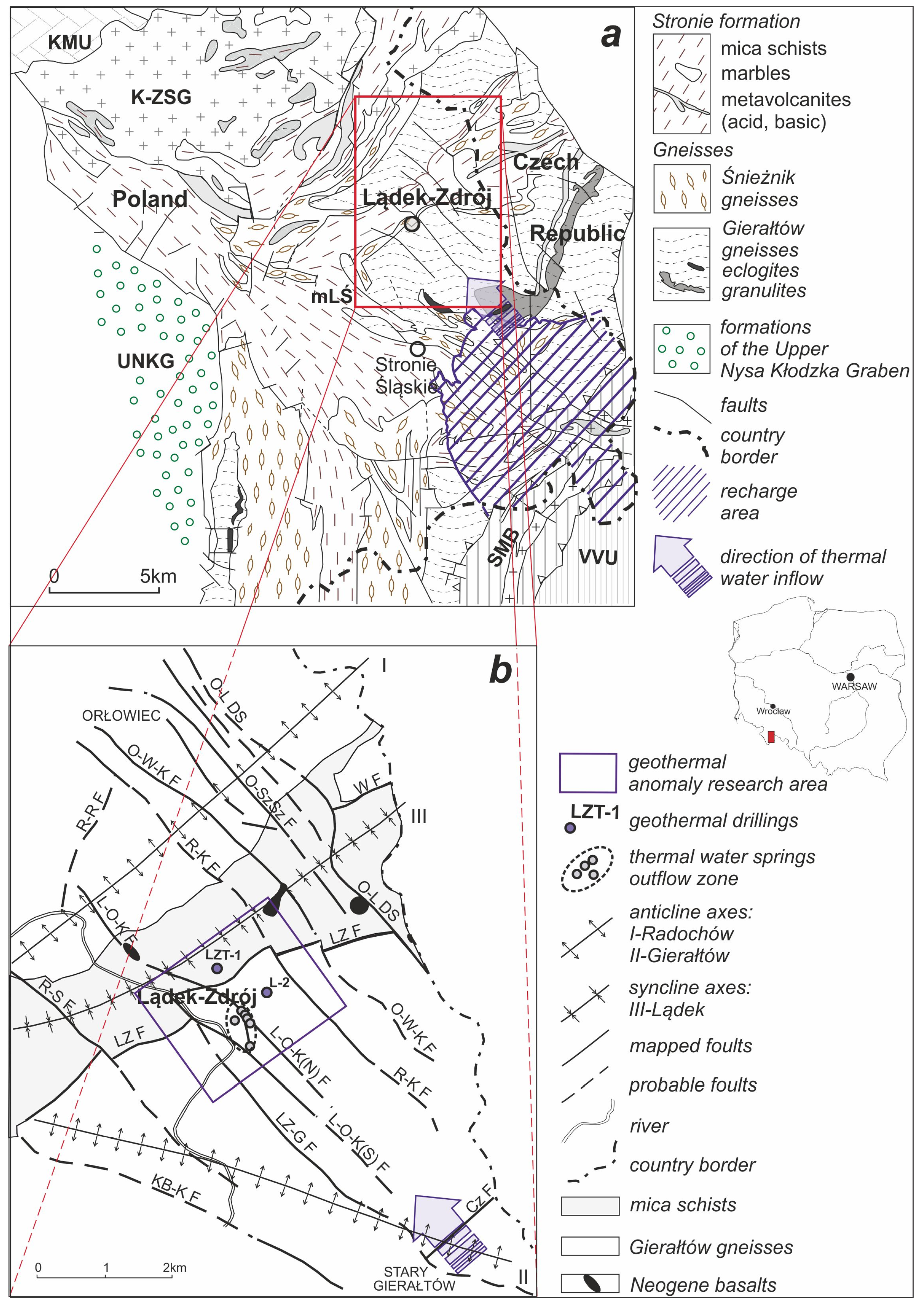
Lądek-Zdrój is situated within the Lądek-Śnieżnik metamorphic unit (mLŚ) [30,31], a part of the Orlica-Śnieżnik Dome [32], east Sudetes, NE Bohemian Massif. Three main rock assemblages of Proterozoic–Early Paleozoic age are identified within this tectonic unit (Figure 1a). The first of these is the Stronie Schist complex, composed of mica schists, crystalline limestone, amphibolites, quartzites, and other metasedimentary and metavolcanic rocks, characterized by mostly unfavorable hydrogeological parameters. Another assemblage is that of Gierałtów migmatitic gneisses, which host the thermal water deposit of Lądek. The third rock assemblage in question is the Śnieżnik gneiss complex, occurring at various levels of the mica schists. The Śnieżnik gneisses in a map view often encircle major concentrations of the Gierałtów gneisses [30,33,34].
In Carboniferous times, granitoid intrusions affected the area, producing the occurrence of mafic dyke rocks and quartz veins in the vicinities of Lądek-Zdrój. The metamorphic complexes in the Lądek area are affected by multiple order fold structures, defining four anticlinoria, where the gneissic rocks crop out, which are interspersed with three synclinoria with mostly schistose rocks at the surface. Near Lądek-Zdrój, specifically within the Gierałtów anticlinorium and the Radochów synclinorium, these fold structures (see Figure 1b) are intersected by a dozen or so transverse faults, striking NW–SE (i.e., in the so-called Sudetic direction), as well as several longitudinal faults [31]. Associated with these faults are four small occurrences of Neogene basalts, dated at 3.83–5.6 Ma (see Figure 1b) with the K-Ar method [35].
Figure 1. Geologic (a) and tectonic (b) maps of the Lądek-Zdrój region with the locations of thermal water intakes (based on ref. [36]). Key: O-L SD—Orłowiec-Lutynia Dislocation System, O-SzSz F—Orłowiec-Szweckie Szańce Fault, O-W-K F—Orłowiec-Wojtówka-Karpno Fault, R-K F—Rasztowiec-Karpno Fault, L-O-K(N) F—Lądek-Orłowiec-Karpno (N) Fault, L-O-K(S) F—Lądek-Orłowiec-Karpno (S) Fault, LZ-G F—Lądek-Zdrój-Gierałtów Fault, R-S F—Radochów-Stójków Fault, KB-K F—Kąty Bystrzyckie-Kłóbka Fault, R-R F—Rasztowiec-Radochów Fault, W F—Wrzosówka Fault, LZ F—Lądek-Zdrój Fault, Cz F—Czepinek Fault.
Energies 17 03362 g001

1.2. Characteristics of the Thermal Water Deposit

Lądek-Zdrój is a health resort with balneotherapeutic traditions dating back to the first half of the 13th century. Flowing out at an altitude of about 450 m a.s.l., the therapeutic waters were captured in six springs until 1973 (see Figure 1b) [37]. These waters exhibit very low mineralization of approximately 0.2 g/dm3 and are characterized by a unique chemical composition of Na-HCO3, F, H2S, and Rn. The concentrations of specific components are 6.8–13 mg/L, 0.2–5.1 mg/L, and 96–1336 Bq/L, respectively [36]. The slightly variable water temperature varies between 20.3 and 28.3 °C in particular springs. In the 1970s, two wells were drilled in Lądek-Zdrój. The L-1 borehole, with a terminal depth of 597.6 m, captures ordinary water from fractured aquifers. Borehole L-2 (Zdzisław), with a terminal depth of 700.3 m, contains waters of identical chemical composition to those found in the springs, with an outflow temperature of 45 °C [38].
Thermal water springs are located at fault intersections [31,33], while inflows of water of deep circulation are linked to major fault zones of a NW–SE strike [38]. This study [39] estimates the age of the waters to be approximately 9000 years and the total volume of water in the system at 1.3 × 10⁹ m3. Studies of stable isotopes of oxygen and hydrogen in the waters suggest their infiltration origin and the location of the recharge area at altitudes above 700 m a.s.l. The recharge area is presumed to be the southeastern Bialskie Mts. and the southern part of the Złote Mts. [38,39,40].
The regional geothermal conditions and the calculation results using chemical geothermometers indicate that the waters in the Lądek system reach temperatures ranging from 50 to 70 °C, with a maximum of 88 °C [41,42,43,44,45,46]. This thermal water deposit is being formed at considerable depth (2–2.5 km), and its waters flowing out at the surface create local anomalies, both hydrogeochemical and geothermal ones [40].
An image of the geothermal anomaly in the near-surface zone was obtained by measurements conducted in 52 shallow wells (to a depth of 30 m) and in the mentioned L-1 and L-2 wells [38,47,48,49]. In the center of this anomaly, a gradient value of 18 °C/100 m was observed. Based on the acquired image (see Figure 2), the following conclusions can be drawn:
  • an outflow of the thermal waters at the ground surface takes place in the bifurcation zone of the Lądek-Orłowiec-Karpno (N) and (S) faults (an anomaly with two clearly marked maxima in the region of the faults);
  • the thermal waters are present in the area contained between the Lądek-Orłowiec-Karpno and Rasztowiec-Karpno faults (since the area north of the Lądek Zdrój resort shows elevated geothermal degree values);
  • the flow of the thermal waters is concentrated (a small horizontal extent of anomalies), and the zone of convective heat inflow in Lądek-Zdrój is limited to the immediate vicinity of the thermal water migration paths.

1.3. Geothermal Settings of the Study Area

According to the map of a surface heat flux in Europe [50], the region of Lądek-Zdrój is situated at the eastern margin of the European Variscan orogen. In this area, the heat flux values are slightly lower (by 10–20 mW/m2) than in the other parts of the orogen. More detailed mapping studies estimate this flux in the Lądek-Zdrój region to range from approximately 45 mW/m2 to a maximum of about 63 mW/m2 (see Table 1).
Within the Lądek-Śnieżnik massif, only one determination of surface heat flux was made in borehole L-1, yielding a value of 1.6 HFU (70.6 mW/m2) [41]. In the close vicinity of the Lądek-Śnieżnik metamorphic unit, in the Niedźwiedź amphibolite massif (approximately 20 km to the north of Lądek-Zdrój), a flux measurement in the well Niedźwiedź IG-2 yielded a heat flux of 69.5 mW/m2 [17]. To the west of the Lądek-Śnieżnik massif, within the Upper Nysa Kłodzka graben, in Długopole (19 km to the southwest of Lądek) and in Stary Waliszów (14 km to the west), Dowgiałło and Fistek [56] estimated the heat flux values at 54.5 and 63.5 mW/m2, respectively. Thus, based on previous estimates, the surface heat flux in the Lądek-Zdrój area is less than 65 mW/m2 [27].
The LZT-1 borehole is situated between the Lądek-Orłowiec-Karpno fault and the Rasztowiec-Karpno fault, approximately 700 m northwest of the center of the Lądek-Zdrój resort. It is located at the margin of the thermal anomaly, where the geothermal gradient is 27–28 m/°C (Figure 2). The results of tests conducted in this well have enabled us to work out a spatial picture of the thermal anomaly in Ladek-Zdrój.
It should be noted that in the Lądek-Śnieżnik massif area, from 1977–1980 a research work was carried out (round one of a planned, but later non-completed more extensive project) aimed at the capture of thermal waters in the Bolesławów area (11 km south of Ladek), as reported by [57]. Based on measurements in shallow boreholes (up to 30 m), geothermal gradient values reaching 6 °C/100 m were obtained. However, due to the lack of demand for thermal water, work on a deep borehole project was abandoned.

1.4. Paleoclimatic Conditions

In Poland, glaciations during the entire Pleistocene period (approximately 1 million years), led to the cooling of rocks to depths of a few kilometers; short interglacial periods periodically disturbed the cooling conditions. The last North Polish glaciation (Weichselian glaciation) (115,000–11,500 years ago) ended with a warming—the current interglacial period, which affects bedrock temperatures to depths of 1.5–2.0 km. Additionally, in the near-surface zone (up to 100–200 m below ground level), the impact of the present Holocene climate warming is also clear [4,5]. The direct impact of low temperatures during the Pleistocene, already under periglacial conditions, caused the cooling and freezing of the bedrock, leading to the development of permafrost zones. Due to the slow rate propagation/diffusion of heat in the rock medium, “signals” of climatic changes from previous epochs are preserved and recorded in rock mass thermal profiling, affecting the overall pattern of heat flow. For example, ref. [17] suggests a depth of thermal equilibrium, i.e., the disappearance of paleoclimate influence, of about 5 km for the Niedźwiedź area (20 km northeast of Ladek-Zdrój). Thus, when analyzing thermal profiles, especially those from deep boreholes, it is necessary to consider the temperature values prevailing at the Earth’s surface during the Pleistocene.

2. Materials and Methods

In Lądek-Zdrój, the LZT-1 well, which reaches a depth of 2.5 km, was drilled between September 2018 and February 2019. The well is located approximately 0.7 km NNW of the existing thermal water intakes in Lądek spa. During the drilling process, schistose rocks of the Stronie series of the Radochów synclinorium were encountered to a depth of 409 m, followed by gneisses of the Gierałtów anticlinorium to the final depth. Two distinct aquifers were identified during drilling. The first one, located in the depth interval of 415.5–664 m, yielded transient conditions, resulting in a water supply with an outflow temperature of 22–23 °C and a specific capacity of 38.75 m3/h. The second, main aquifer was encountered in the depth interval of 1470–1795 m. It produces water with a temperature (outflow) of 42–43 °C and a yield of 56 m3/h, with a depression set at 68.2 m below the ground level. Following the completion of the drilling, pumping of the well within the unlined zone of 1304–2500 m b.g.l. was conducted to estimate the exploitable resources of the intake. During pumping at rates of 10 m3/h and 5 m3/h, stabilization of the water table was achieved at depths of 224.4 m below ground level and 107.6 m below ground level, respectively. At that time, the water temperatures measured at the outflow were 37.4 °C and 32.3 °C, respectively. The chemical composition of the water flowing into this well closely resembled that of the spa water (Na-SO4-HCO3, TDS = 0.2 g/L, F = 11 mg/L, 222Rn = 94 Bq/L, and H2S = 0.72 mg/L). The relatively low discharge values were attributed to the untreated walls of the well and their impact on the spa intakes [58,59]. Consequently, no exploitable resources were established. After the pumping was completed, the groundwater table became established at a depth of 29.1 m b.g.l. Temperature profiling in the borehole was conducted after 14 days of shutdown within the depth interval of 1.0–2500.0 m.
The thermal conductivity of gneiss and schist samples collected from different depths in the LZT-1 borehole typically exceeds 2.3 W/m·°C, with a maximum value of 3.25 W/m·°C (Table 2). These values are approximately 0.25 W/m·°C higher than those estimated by ref. [52], which were ca. 2 W/m·°C for the region.
The Pleistocene glaciations clearly influenced the bedrock thermal conditions in this part of Europe. During the last glaciation (the Weichselian Glaciation), the average annual temperature in Poland ranged between −12 °C and −8 °C [61]. In the periglacial climate zone, at latitudes of 50° N and 55° N, the temperatures were −3 °C and −5 °C, respectively [8]. For the Lądek-Zdrój region, situated at latitude 50°20′ N, a paleotemperature value of −5.5 °C was assumed based on ref. [4]. The assumed surface paleotemperature in the Pleistocene (−5.5 °C) was used to determine the temperature correction and then calculate the temperature of the rock mass (from the ground surface to a depth of 2.5 km) under the influence of glaciations. The obtained results were compared with the results of the temperature logs of the LZT-1 borehole. These are estimated values which result from a wide range of paleotemperatures, from −7 °C to +7 °C [4]. Furthermore, it was assumed that temperature fluctuations associated with seasonal climate changes would no longer affect rock mass temperatures below a depth of 240 m [62].
In the literature, various formulas can be found to recalculate the bottom hole temperature (BHT) under equilibrium/stability conditions, primarily based on experimental data and/or mathematical modelling. Among the most used methods are, e.g., the Horner method, the simple Corrigan correction, and the correction referred to by ref. [29] as the Kukkonen–Szewczyk method. The Horner method provides reliable results for the acquired Tsc (time since circulation) data within a range of up to tens of hours, with at least three pairs of measurements required [63]. However, it is important to note that the assumption that the equilibrium temperature depth in the wellhole is at half of its total depth in this method is purely a theoretical simplification.
The modified method of ref. [64], as well as the previously mentioned methods of Carrigan and Kukkonen–Szewczyk, were used to ascertain the corrected temperature (to thermal equilibrium conditions) at the bottom of the LZT-1 borehole. When analyzing refs. [29,64,65,66], we can find a synthetic description of the methodological assumptions. In the calculations, an equilibrium depth of Heq = 1850 m b.g.s. was assumed, from which a steady temperature increase was observed with Tsc = 3.5 h [58]. Subsequently, considering the influence of glaciation cycles, a synthetic heat flow profile was computed. Extrapolating the linear segment of the thermal profile upward, delineated by the thermal conductivity of rocks and by deep water flow, and assessing its deviation from the temperature measured in the borehole made it possible to determine the temperature anomaly.

3. Results

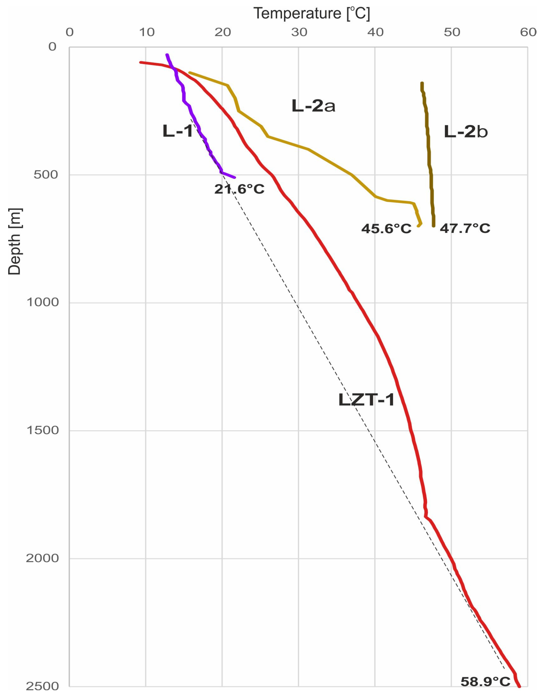
Figure 3 summarizes the temperature profiles of three boreholes drilled in the geothermal anomaly in Lądek-Zdrój. It can be assumed that the L-1 well, situated practically outside the extent of the geothermal anomaly (Figure 2), exhibits temperature variations in its profile that illustrate the natural, undisturbed thermal conditions of the metamorphic series in the vicinities of Lądek-Zdrój to a depth of several hundred meters. The thermal characteristics of the center of the anomaly are depicted by the data from the L-2 well (Figure 3). The temperature measurements of water during its spontaneous discharge while drilling this well (L-2a) can be assumed to indicate successive stages of warm-up of the well. Stable thermal conditions of the rock mass within the anomaly in question are suggested by the results obtained after a 5-month “standstill” period, with continuous spontaneous outflow of water from this hole (L-2b). It is notable that there was only a slight increase in temperature, approximately 1.5 °C, in the depth interval of 140–697 m below ground level. On the other hand, due to the specific location of the LZT-1 borehole with respect to the thermal anomaly, its thermal profile shows the temperature distribution in the marginal, northwest parts of the anomaly.
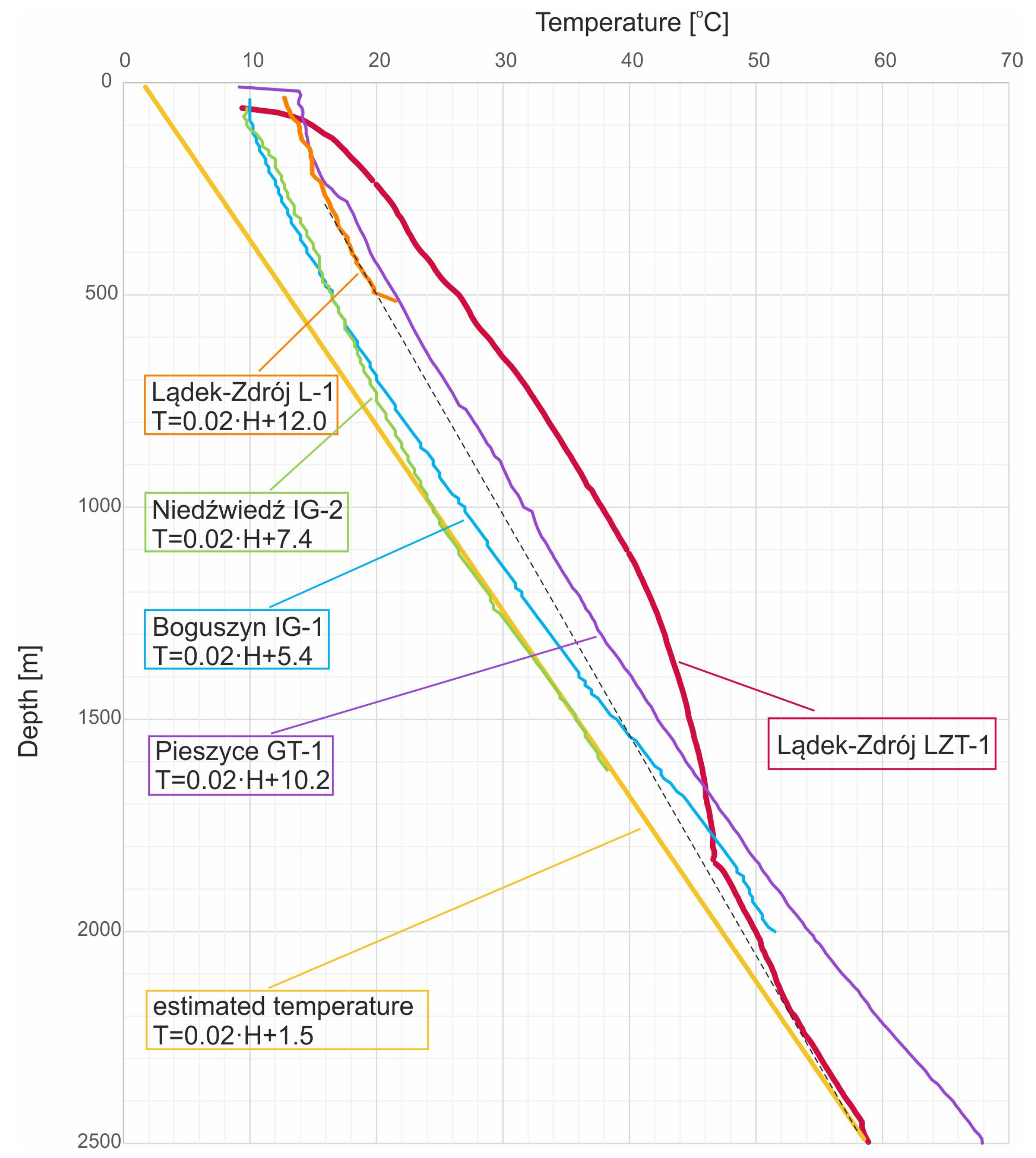
The thermal conditions of the Lądek-Zdrój vicinities, controlled by the natural geothermal gradient and, additionally, by paleoclimatic parameters, are illustrated by the theoretical line of estimated/synthetic temperatures (Ts). This line was determined while considering the results of the temperature log in the LZT-1 borehole and the temperature correction (yellow line in Figure 4). Additionally, Figure 4 also presents the results of the temperature profile carried out in the Boguszyn IG-1, Pieszyce GT-1, and Niedźwiedź IG-2 wells, all without the paleoclimatic correction. These latter boreholes are in other geological units than LZT-1: the Boguszyn IG-1 well in sedimentary rock series of the Bardo structure, the Pieszyce GT-1 in the Góry Sowie metamorphic unit, and the Niedźwiedź IG-2 within the Niedźwiedź massif (comprising amphibolites, crystalline schists, and amphibolite gneisses). The boreholes are located at distances of approximately 20 and 45 km northwest and about 20 km northeast of Lądek-Zdrój, respectively.
The temperature profiles made in the mentioned boreholes allow us to conclude that the prevailing borehole thermal conditions reflect the local geothermal conditions (Figure 4).
The profiles of the boreholes are shifted to the right with respect to the theoretical straight line Ts. For the LZT-1 well, this shift reaches a value of ca. 13 °C. Noteworthy are the similar values of the geothermal gradient in all the boreholes in question (Figure 4).
In the case of the LZT-1 well, the geothermal gradient is 1.83 °C/100 m, while for the Niedźwiedź IG-2 borehole, it is 1.87 °C/100 m (see Table 3). The Boguszyn IG-1 and Pieszyce GT-1 boreholes yielded gradients of 2.18 °C/100 m and 2.23 °C/100 m, respectively (to eliminate the influence of atmospheric conditions on the determined values and to standardize the results, data from the well sections between a depth of 100 m and the bottom of each well were used). Plewa and Sroka [67] obtained a value of 2.16 °C/100 m from a lower (below a depth of 1000 m) linear section in the profile from the Niedźwiedź IG-2 borehole. For the LZT-1 well, assuming a linear temperature increase from a depth of 1850 m below sea level, this gradient is 1.93 °C/100 m (see Table 3). It should be noted that these depths are still within the rock mass zone of transitional conditions, i.e., above the thermal equilibrium limit [4,17]. In addition to paleoclimatic conditions, these values of the geothermal gradient are undoubtedly influenced by the lithological and petrographic properties of the drilled rocks, as emphasized by ref. [60], when analyzing the variability in thermal conductivity of the Sudetic rocks.
The dissimilarity of the temperature distribution in the LZT-1 well compared to the other boreholes is clearly visible. Attention is drawn to the coincidence of the lower part of the LZT-1 profile with the line approximating the temperature profile in the L-1 borehole (shown as a black dashed line in Figure 3 and Figure 4). The shift of the LZT-1 borehole profile towards higher temperatures in the depth interval of 100–1800 m indicates an additional lateral heat input.
The maximum temperature at the bottom of the well measured during logging was 58.92 °C (Figure 3). Assuming an equilibrium temperature in the borehole after the completion of mud circulation, it was estimated that a temperature ranging from about 70 °C to about 80 °C could be expected at the bottom of the borehole, depending on the method used (Table 4). It is worth mentioning that using chemical multicomponent geothermometers and thermodynamic modeling, a reservoir temperature value of 88 ± 16 °C was obtained [46]
Peters and Nelson [63] suggest that due to the variability in diffusive heat migration, the properties of a rock medium, mud composition, and the construction of the borehole (including the type of casing, depth of installation, and cementing), all the methods of bottom-hole temperature correction (BHT) should rather be considered as approximate. However, in the case of the analyzed well, the temperature values thus obtained (Table 4) agree with archival data and the results of temperature estimation using multicomponent geothermometers.
Plewa et al. [71] determined an HF (heat flux) value of 46.6 mW/m2 for the Niedźwiedź Massif, using data from the Niedźwiedź IG-2 borehole. After applying the paleoclimatic correction for this well, the corrected heat flux value was calculated as 69.5 mW/m2 [17]. Making use of the relationship established by ref. [72] and based on data from the LZT-1 well, a heat flux (HF) value of 64 mW/m2 was determined for the Lądek-Zdrój vicinities. This value is notably higher compared to the heat flux density estimated by ref. [26] in the range of 28–36 mW/m2 as appropriate for areas with Neogene active volcanism. However, the calculated HF value is consistent with the parameter values determined considering paleoclimatic conditions by refs. [2,72], although slightly lower (by approximately 4–5 mW/m2) than the estimations by ref. [4]. As noted previously, Dowgiałło [41] initially determined the heat flux value in Ladek-Zdrój as 70.6 mW/m2. However, without incorporating this correction, it amounts to only 50.84 mW/m2 [59].
The relatively high values of heat flux in the Variscides of Poland (60–65 mW/m2) can be attributed to their proximity to areas of the Alpine system [62,73].

4. Discussion

4.1. Geothermal Anomaly

In the opinion of the present authors, by drilling the LZT-1 well and carrying out temperature logging (Figure 4), the description of the drainage zone (i.e., the end part of the Lądek-Zdrój hydrogeological system) can be made more precise. More than 40 years ago, Ciężkowski [38] proposed a scheme for the circulation of thermal waters in the Lądek-Zdrój resort. The results obtained in the LZT-1 well make it possible to significantly refine this scheme.
According to this scheme, thermal waters are formed from infiltration within the recharge areas and migration along the main fault and fracture zones within the gneisses (at depths of 2–2.5 km) towards Lądek-Zdrój. There, at the intersection of major tectonic discontinuities, the heated waters migrate toward the surface, creating a distinct geothermal anomaly. The waters flowing out in the springs located in its center have a temperature of about 30 °C. It is worth noting that the flow direction of water is impeded by the transverse synclinal zone of Ladek, comprised of impermeable rocks of the Stronie series (Figure 1b).
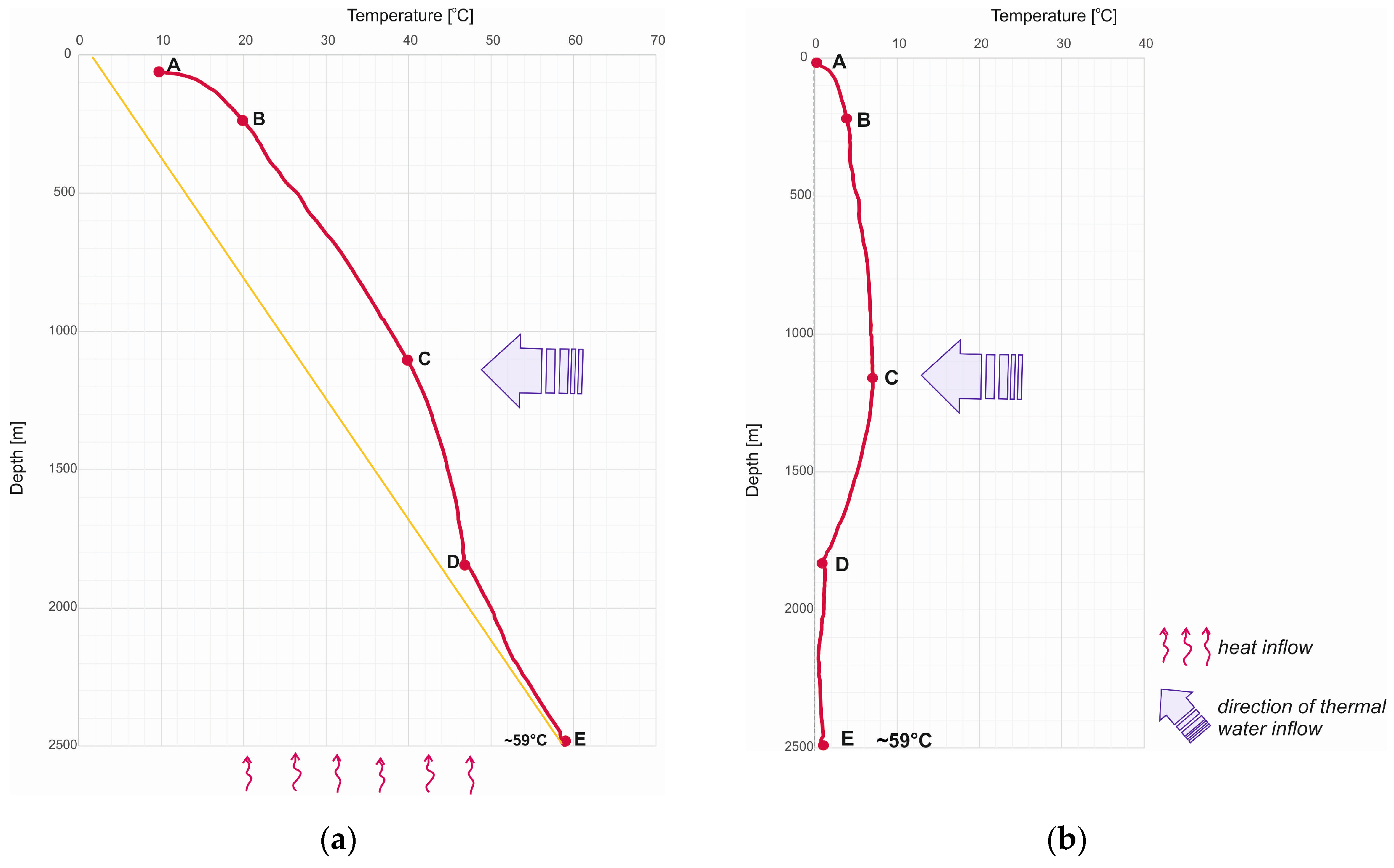
The nature of the geothermal anomaly is depicted in the graphs in Figure 5. Figure 5a presents the true temperature variations measured in the well. The temperature profile is affected by convective heat migrating from below and the additional heat supplied by the warm thermal waters flowing into the Lądek-Zdrój area. In contrast, Figure 5b illustrates the temperature profile in the same well without considering the convective component.
The shape of the temperature curve indicates that the primary heat input to the LZT-1 borehole occurs at a depth of approximately 1100–1200 m (point C in Figure 5). The temperature decreases with depth and, between points C and D, corresponds to the cooling of the inflowing heat by a rock mass cooled by Pleistocene glaciations and heated solely by convective heat. However, a slight temperature decrease (by 3–4 °C) with decreasing borehole depth, that is, between points C and B, is attributed to the interplay of two factors. On the one hand, thermal water migrating from depth towards the surface along its flow paths almost uniformly heats the rock mass. On the other hand, it is cooled by the inflow of cooler waters from the shallow circulation system. Consequently, the slope of the curve between points C and B is much less pronounced than that between points C and D.
In the upper section (AB) of the profile, the migration of shallow infiltration waters and the fractured nature of the upper parts of the rock mass cause a reduction in the thermal conductivity of the rock medium. Consequently, this leads to a decrease in heat diffusivity [74]. As a result, relatively low temperatures are observed, which are further influenced by seasonal climate changes.
In this way, the water flowing into the area of Lądek-Zdrój at a depth of more than 2.5 km primarily moves towards the springs and the L-2 well, with its smaller portion flowing further to the northwest, creating an anomalously heated area extending to the transverse fault of Ladek-Zdrój. The extent of the anomaly itself is limited, and borehole LZT-1, from a depth of about 1800 m, enters deeper into the rock mass undisturbed by the anomaly and cooled by Pleistocene glaciations (Figure 6).
The north-westerly direction of the water flow is also indicated by the difference in the height of the water table between the L-2 and LZT-1 boreholes, which decreases by about 5 m between the two. However, the question arises as to where the thermal water flowing into the impermeable rocks of the Stronie series moves. The Stronie series generally forms an impermeable barrier to the thermal water flow. The effectiveness and continuity of the barrier can be seen at the boundaries of the mentioned anomaly. Studies carried out in the Lądek-Śnieżnik metamorphic complex confirm the lower permeability of the schist series [75]. This phenomenon is also clearly visible on the scale of the whole Czech massif [76]. Assuming lateral spreading, the northeast direction seems more plausible, as, in such a case, the outflow of water would be towards the drainage base located much lower.

4.2. Activation of the Water System

The timing of the activation of the Lądek thermal water system/complex is also an interesting issue. While the faults and associated fracture systems were formed in the Neogene, the activation of the water flow probably occurred after the springs’ outflow sites were exposed at the surface. These outflows are located at an altitude of about 450 m above sea level, about 15 m above the level of the Biała Lądecka River. This altitude corresponds to the location of the Pleistocene high gravel terrace (12–20 m) that occurs in several areas of the Lądek and Śnieżnik metamorphic massif. According to ref. [77], it is related to the Middle Polish glaciation (300–170 ka). This terrace has also been documented in Lądek-Zdrój a few hundred meters west of the springs and below the village, at the foot of the Szary Kamień basalt outcrop [78].
The intense earthquake activity in the region, dated at time intervals of 320–306, 253–236, 162–158, 132–135, and more than 21 ka probably also played a role in the activation of the Lądek-Zdrój thermal water system. This tectonic activity is evidenced by speleothem deformation in the nearby Niedźwiedzia Cave in Kletno [79].

5. Conclusions

The drilling of the LZT-1 well in Lądek-Zdrój has allowed the determination of geothermal conditions in this locality and a refinement of previous interpretations of the Lądek geothermal anomaly. Based on the temperature profile from this well and the synthetic temperatures derived from it (Figure 4), it can be concluded that thermal conditions dominated by the influence of Pleistocene low temperatures continue to prevail in the Lądek area bedrock below a depth of 1100 m. This is particularly evident in the lower section (DE) of the borehole profile, corresponding to the thermal conditions of the glacial periods.
The estimated temperature at the bottom of the LZT-1 well under thermal equilibrium conditions falls in the range of 70 °C to 80 °C, depending on the method used.
Considering the views of ref. [73], the anomalous values of heat flux (about 64 mW/m2) are attributed to young Alpine volcanic activity. Due to the high heat flux values (associated with the geothermal anomaly mentioned), determining the maximum depth to which the rock mass has cooled is challenging. The anomaly itself is undoubtedly the result of the inflow of geothermal waters from the recharge areas and the transport of heat from the deep parts of the bedrock near the bifurcation zone of the major Lądek-Orłowiec-Karpno fault. It illustrates the response of the rock medium to an increase in the average annual temperature at the Earth’s surface after the glacial periods and the activation of the deep circulation system.
The flow of ground water within the Lądek system began approximately 200,000 years ago. Since the age of the water, determined by the radiocarbon method, reaches 9000 years, there have been multiple complete replacements of the water since the start of the system, occurring more than 20 times.

Author Contributions

Conceptualization, W.C. and B.K.; methodology, B.K. and W.C.; software, B.K. and K.S.; formal analysis, B.K.; investigation, B.K., W.C. and K.S.; resources, B.K., W.C., I.S., M.W. and M.R.; data curation, B.K. and I.S.; writing—original draft preparation, B.K.; writing—review and editing, W.C. and B.K.; visualization, B.K.; supervision, B.K. All authors have read and agreed to the published version of the manuscript.

Funding

The research was carried out as a part of preparatory work for the project “Geothermal Atlas of the Sudetes and their Foreland” (WUST project No. 4001/0020/23).

Data Availability Statement

Data are contained within the article.

Acknowledgments

The authors thank the Department of Mining, of Wrocław University of Science and Technology for support during the preparation and publication of this paper.

Conflicts of Interest

The authors declare no conflicts of interest.

References

  1. Golovanova, I.V.; Sal’manova, R.Y.; Tagirova, C.D. Method for deep temperature estimation with regard to the paleoclimate influence on heat flow. Russ. Geol. Geophys. 2014, 55, 1130–1137. [Google Scholar] [CrossRef]
  2. Majorowicz, J.; Wybraniec, S. New terrestrial heat flow map of Europe after regional paleoclimatic correction application. Int. J. Earth Sci. 2011, 100, 881–887. [Google Scholar] [CrossRef]
  3. Szewczyk, J. Estymacja gęstości strumienia cieplnego metodą modelowań własności termicznych ośrodka. Przegląd Geol. 2001, 49, 1083–1088. [Google Scholar]
  4. Szewczyk, J.; Gientka, D. Terrestrial heat flow density in Poland—A new approach. Geol. Q. 2009, 53, 125–140. [Google Scholar]
  5. Szewczyk, J. Ślady zmian klimatycznych plejstocenu oraz holocenu w profilach temperatury w głębokich otworach wiertniczych na Niżu Polskim. Przegląd Geol. 2002, 50, 1109–1113. [Google Scholar]
  6. Szewczyk, J. Geofizyczne oraz hydrogeologiczne warunki pozyskiwania energii geotermicznej w Polsce. Przegląd Geol. 2010, 58, 566–573. [Google Scholar]
  7. Galushkin, Y. Numerical simulation of permafrost evolution as a part of sedimentary basin modeling: Permafrost in the Pliocene—Holocene climate history of the Urengoy field in the West Siberian basin. Can. J. Earth Sci. 1997, 34, 935–948. [Google Scholar] [CrossRef]
  8. Kukkonen, I.T.; Golovanova, I.V.; Khachay, Y.V.; Druzhinin, V.S.; Kosarev, A.M.; Schapov, V.A. Low geothermal heat flow of the Urals fold belt—Implication of low heat production, fluid circulation or palaeoclimate? Tectonophysics 1997, 276, 63–85. [Google Scholar] [CrossRef]
  9. Clauser, C.; Giese, P.; Huenges, E.; Kohl, T.; Lehmann, H.; Rybach, L.; Safanda, J.; Wilhelm, H.; Windloff, K.; Zoth, G. The thermal regime of the crystalline continental crust: Implications from the KTB. J. Geophys. Res. 1997, 102, 18417–18441. [Google Scholar] [CrossRef]
  10. Šafanda, J.; Rajver, D. Signature of the last ice age in the present subsurface temperatures in the Czech Republic and Slovenia. Global Planet. Change 2001, 29, 241–257. [Google Scholar] [CrossRef]
  11. Kukkonen, I.T.; Gosnold, W.D.; Šafanda, J. Anomalously low heat flow density in eastern Karelia, Baltic Shield. Tectonophysics 1998, 291, 235–249. [Google Scholar] [CrossRef]
  12. Kukkonen, I.T.; Jõeleht, A. Weichselian temperatures from geothermal heat flow data. J. Geophys. Res. 2003, 108, 2163. [Google Scholar] [CrossRef]
  13. Golovanova, I.V.; Puchkov, V.N.; Sal’manova, R.Y.; Demezhko, D.Y. A new version of the heat flow map of the Urals with paleoclimatic corrections. Dokl. Earth Sci. 2008, 422, 1153–1156. [Google Scholar] [CrossRef]
  14. Szewczyk, J. Wpływ zmian klimatycznych na temperaturę podpowierzchniową Ziemi. Przegląd Geol. 2005, 53, 77–86. [Google Scholar]
  15. Szewczyk, J.; Gidziński, T.; Gientka, D. Anomalia geotermiczno-hydrogeochemiczna rejonu Krzemianka–Udryń—Pozostałość głębokiej zmarzliny. Mat. Symp. Współczesne Probl. Hydrogeol. 2003, XI, 229–236. [Google Scholar]
  16. Szewczyk, J.; Nowicki, Z.; Gientka, D. Występowanie głębokiej zmarzliny w okresie zlodowacenia Wisły na obszarze Niżu Polskiego—Implikacje paleohydrogeologiczne oraz geotermiczne. Mat. Symp. Współczesne Probl. Hydrogeol. 2007, XIII, 203–211. [Google Scholar]
  17. Puziewicz, J.; Czechowski, L.; Krysiński, L.; Majorowicz, J.; Matusiak-Małek, M.; Wróblewska, M. Litosphere thermal structure at the eastern margin of the Bohemian Massif: A case petrological and geophysical study of the Niedźwiedź amphibolite massif (SW Poland). Int. J. Earth Sci. 2012, 101, 1211–1228. [Google Scholar] [CrossRef]
  18. Majorowicz, J. Permafrost at the ice base of recent pleistocene glaciations–inferences from borehole temperature profiles. Biull. Geogr.—Phys. Geogr. Ser. 2012, 5, 7–28. [Google Scholar] [CrossRef]
  19. Majorowicz, J.; Šafanda, J. Heat flow variation with depth in Poland: Evidence from equilibrium temperature logs in 2.9-km-deep well Toruń-1. Int. J. Earth Sci. 2008, 97, 307–315. [Google Scholar] [CrossRef]
  20. Šafanda, J.; Szewczyk, J.; Majorowicz, J. Geothermal evidence of very low glacial temperatures on a rim of the Fennoscandian ice sheet. Geophys. Res. Lett. 2004, 31, L07211. [Google Scholar] [CrossRef]
  21. Szewczyk, J.; Nawrocki, J. Deep-seated relict permafrost in northeastern Poland. Boreas 2011, 40, 385–388. [Google Scholar] [CrossRef]
  22. Mottaghy, D.; Majorowicz, J.; Rath, V. Ground surface temperature histories reconstructed from boreholes in Poland: Implications for spatial variability. In The Polish Climate in the European Context: An Historical Overview; Przybylak, R., Majorowicz, J., Brázdil, R., Kejna, M., Eds.; Springer: Berlin/Heidelberg, Germany, 2009; pp. 375–387. [Google Scholar]
  23. Förster, A. Analysis of borehole temperature data in the Northeast German Basin: Continuous logs versus bottom-hole temperatures. Pet. Geosci. 2001, 40, 241–254. [Google Scholar] [CrossRef]
  24. Majorowicz, J. Wieloznaczność tektonicznej interpretacji rozkładu pola geotermicznego na obszarach platformowych Polski. Przegląd Geol. 1982, 30, 86–94. [Google Scholar]
  25. Majorowicz, J.; Šafanda, J.; Przybylak, R.; Wójcik, G. Ground Surface Temperature History in Poland in the 16th-20th Centuries Derived from the Inversion of Geothermal Profiles. Pure Appl. Geophys. 2004, 161, 351–363. [Google Scholar] [CrossRef]
  26. Majorowicz, J.; Grad, M. Differences between Recent Heat Flow Maps of Poland and Deep Thermo-Seismic and Tectonic Age Constraints. Int. J. Terr. Heat. Flow. Appl. Geotherm. 2020, 3, 11–19. [Google Scholar] [CrossRef]
  27. Majorowicz, J. Review of the Heat Flow Mapping in Polish Sedimentary Basin across Different Tectonic Terrains. Energies 2021, 14, 6103. [Google Scholar] [CrossRef]
  28. Clauser, C. Thermal Signatures of Heat Transfer Processes in the Earth’s Crust; Springer: Berlin/Heidelberg, Germany, 1999. [Google Scholar]
  29. Kudrewicz, R. A 3D model of the thermal field within the Polish Carpathians and the Carpathian Foredeep (S Poland). Geol. Q. 2021, 65, 1–26. [Google Scholar] [CrossRef]
  30. Don, J. Góry Złote i Krowiarki jako elementy składowe metamorfiku Śnieżnika. Geol. Sudet. 1964, I, 79–117. [Google Scholar]
  31. Gierwielaniec, J.Z. geologii Lądka-Zdroju. Pr. Nauk. Inst. Geotech. PWr. 1970, 5, 1–43. [Google Scholar]
  32. Żelaźniewicz, A. Przeszłość geologiczna. In Przyroda Dolnego Śląska; Fabiszewski, J., Ed.; PAN—Oddział we Wrocławiu: Wrocław, Poland, 2005; pp. 61–134. [Google Scholar]
  33. Gierwielaniec, J. Lądek Zdrój i jego wody mineralne. Kwart. Geol. 1968, 12, 680–692. [Google Scholar]
  34. Żelaźniewicz, A.; Aleksandrowski, P.; Buła, Z.; Karnkowski, P.H.; Konon, A.; Oszczypko, N.; Ślączka, A.; Żaba, J.; Żytko, K. Regionalizacja Tektoniczna Polski; Wydawnictwo Komitetu Nauk Geologicznych Polskiej Akademii: Wrocław, Poland, 2011. [Google Scholar]
  35. Birkenmajer, K.; Pecskay, Z.; Grabowski, J.; Lorenc, M.W.; Zagożdżon, P.P. Radiometric dating of the Tertiary volcanics in Lower Silesia, Poland. II. K-Ar dating and paleomagnetic data from Neogene basanites near Lądek-Zdrój, Sudetes Mts. Ann. Soc. Geol. Polon. 2002, 72, 119–129. [Google Scholar]
  36. Kiełczawa, B.; Ciężkowski, W.; Wąsik, M.; Rasała, M. Hydrochemical Characteristics of Thermal Water Reservoir in Lądek-Zdrój in Light of Research into the Borehole LZT-1—The Deepest Borehole in the Sudetes (SW Poland). Energies 2021, 14, 1009. [Google Scholar] [CrossRef]
  37. Ciężkowski, M.; Ciężkowski, W. Źródła Lądka Zdroju. Historia i badania. Balneol. Pol. 1983, XXVII, 5–19. [Google Scholar]
  38. Ciężkowski, W. Hydrogeologia i hydrochemia wód termalnych Lądka-Zdroju. Probl. Uzdrow. 1980, 4, 125–193. [Google Scholar]
  39. Zuber, A.; Weise, S.; Osenbrück, K.; Grabczak, J.; Ciężkowski, W. Age and recharge area of thermal waters in Lądek Spa (Sudeten, Poland) deduced from environmental isotope and noble gas data. J. Hydrol. 1995, 167, 327–349. [Google Scholar] [CrossRef]
  40. Ciężkowski, W. Studium Hydrogeochemii wód Leczniczych Sudetów Polskich; Prace Naukowe Instytutu Geotechniki Politechniki Wrocławskiej; Monografie 19; Wydawnictwo Politechniki Wrocławskiej: Wrocław, Poland, 1990. [Google Scholar]
  41. Dowgiałło, J. Wody termalne Sudetów. Acta Geol. Pol. 1976, 26, 617–643. [Google Scholar]
  42. Dowgiałło, J. Geochemiczne wskaźniki temperatury i ich zastosowanie do sudeckich wód termalnych. In Proceedings of the Mat. Symp. “Stan Rozpoznania i Perspektywy Wykorzystania wód Termalnych”, Warszawa-Kraków, Polska, 24–25 October 1985. [Google Scholar]
  43. Dowgiałło, J.; Florkowski, T.; Grabczak, J. Tritium and 14C dating of Sudetic thermal waters. Bull. Pol. Acad. Sci.-Earth Sci. 1974, 22, 101–109. [Google Scholar]
  44. Dowgiałło, J.; Hałas, S.; Porowski, A. Isotope temperature indicators of thermal waters in South-Western Poland. In Proceedings of the World Geothermal Congress, Antalya, Turkey, 24–29 April 2005; pp. 1–8. [Google Scholar]
  45. Porowski, A.; Dowgiałło, J. Application of selected geothermometers to exploration of low-enthalpy thermal water: The Sudetic Geothermal Region in Poland. Environ. Geol. 2009, 58, 1629–1638. [Google Scholar] [CrossRef]
  46. Kiełczawa, B. Determination of Reservoir Temperatures of Low-Enthalpy Geothermal Systems in the Sudetes (SW Poland) Using Multicomponent Geothermometers. Water 2023, 15, 422. [Google Scholar] [CrossRef]
  47. Szarszewska, Z. Dokumentacja Hydrogeologiczna wód Leczniczych z Utworów Prekambru Ujętych Odwiertem L-600 w Lądku Zdroju, PPOTU: Warszawa, Poland, 1971; unpublished.
  48. Kiełczawa, B.; Liber-Makowska, E. Warunki geotermiczne rejonu Lądka-Zdroju. Tech. Poszuk. Geol. Geoterm. Zrównoważony Rozw. 2017, 2, 105–115. [Google Scholar]
  49. Szarszewska, Z.; Madej, E. Sprawozdanie z Badań Związanych z Poszukiwaniem wód Termalnych w Lądku Zdroju, BP Balneoprojekt: Warszawa, Poland, 1974; unpublished.
  50. Hurter, S.; Haenel, R. Atlas of geothermal resources in Europe; European Commission: Luxembourg, 2002. [Google Scholar]
  51. Myslil, V.; Stibitz, M.; Frydrych, V. Geothermal Energy Potential of Czech Republic. In Proceedings of the World Geothermal Congress, Antalya, Turkey, 24–29 April 2005. [Google Scholar]
  52. Bruszewska, B. Warunki geotermiczne Dolnego Śląska. Przegląd Geol. 2000, 48, 639–643. [Google Scholar]
  53. Plewa, S. Rozkład parametrów geotermalnych na obszarze Polski; Wyd. CPPGSMiE PAN: Kraków, Poland, 1994; pp. 1–38. [Google Scholar]
  54. Majorowicz, J.; Plewa, S. Study of Heat Flow in Poland with Special Regard to Tectonophysical Problems. In Terrestrial Heat Flow in Europe; Čermák, V., Rybach, L., Eds.; Springer: Berlin/Heidelberg, Germany, 1979; pp. 240–252. [Google Scholar]
  55. Čermák, V. Review of Heat Flow Measurements in Czechoslovakia. In Terrestrial Heat Flow in Europe; Čermák, V., Rybach, L., Eds.; Springer: Berlin/Heidelberg, Germany; New York, NY, USA, 1979; pp. 152–160. [Google Scholar]
  56. Dowgiałło, J.; Fistek, J. New findings in the Wałbrzych-Kłodzko geothermal sub-region (Sudetes, Poland). Geothermics 2003, 32, 689–699. [Google Scholar] [CrossRef]
  57. Ciężkowski, W.; Płochniewski, Z. Poszukiwanie wód termalnych w rejonie Bolesławowa w Masywie Śnieżnika. Mat. Symp. Współczesne Probl. Hydrogeol. 1983, II, 262–270. [Google Scholar]
  58. Rasała, M.; Ciężkowski, W.; Wąsik, M.; Kiełczawa, B. Dokumentacja geologiczna z wykonania prac geologicznych niekończących się udokumentowaniem zasobów złoża kopaliny w związku z wykonaniem otworu poszukiwawczego za wodami termalnymi LZT-1 w Lądku-Zdroju. Arch. Gm. Lądek-Zdrój, 2019; unpublished. [Google Scholar]
  59. Kiełczawa, B.; Wąsik, M.; Szostak, K.; Rasała, M.; Ciężkowski, W. Otwór LZT-1 w Lądku-Zdroju—Obiecujący potencjał, niewykorzystane możliwości. Przegląd Geol. 2024, 72, 174–181. [Google Scholar] [CrossRef]
  60. Śmiszek, R. Wyniki badań fizycznych właściwości skał obszaru sudeckiego. In Badania Ciepła Radiogenicznego Skał Krystalicznych i Osadowych Obszaru Sudeckiego; Plewa, M., Ed.; Prace Geol. nr 141, Kom. Nauk. Geol. PAN: Kraków, Poland, 1996; pp. 21–53. [Google Scholar]
  61. Szewczyk, J. The deep-seated lowland relict permafrost from the Suwałki region (NE Poland)—Analysis of conditions of its development and preservation. Geol. Q. 2017, 61, 845–858. [Google Scholar] [CrossRef]
  62. Majorowicz, J. Obraz pola cieplnego Ziemi w obszarze Polski. Rocznik PTG 1974, XLIV, 425–445. [Google Scholar]
  63. Peters, K.; Nelson, P. Criteria to Determine Borehole Formation Temperatures for Calibration of Basin and Petroleum System Models. In Analyzing the Thermal History of Sedimentary Basins: Methods and Case Studies; Harris, N., Peters, K., Eds.; SEPM Special Publication: Tulsa, OK, USA, 2012; pp. 5–15. [Google Scholar]
  64. Waples, D.W.; Pacheco, J.; Vera, A. A method for correcting log-derived temperatures in deep wells, calibrated in the Gulf of Mexico. Pet. Geosci. 2004, 10, 239–245. [Google Scholar] [CrossRef]
  65. Waples, D.W.; Ramly, M. A statistical method for correcting log-derived temperatures. Pet. Geosci. 2001, 7, 231–240. [Google Scholar] [CrossRef]
  66. Zare-Reisabadi, M.; Kamali, M.R.; Mohammadnia, M.; Shabani, F. Estimation of true formation temperature from well logs for basin modeling in Persian Gulf. J. Pet. Sci. Eng. 2015, 125, 13–22. [Google Scholar] [CrossRef]
  67. Plewa, M.; Sroka, K. Gęstość powierzchniowego strumienia cieplnego Ziemi w rejonie sudeckim. In Badania Ciepła Radiogenicznego Skał Krystalicznych i Osadowych Obszaru Sudeckiego; Plewa, M., Ed.; Prace Geol. nr 141, Kom. Nauk. Geol. PAN: Kraków, Poland, 1996; pp. 54–60. [Google Scholar]
  68. Chorowska, M.; Milewicz, J.; Radlicz, K.; Rydzewski, A. Badania wgłębnej budowy geologicznej wschodniej części Dolnego Śląska. Dokumentacja wynikowa otworu Boguszyn IG-1, CUG IG Oddział Dolnośląski: Wrocław, Poland, 1984; unpublished.
  69. Fryziak, T. Pomiary Geofizyczne w Otworze Pieszyce GT-1; Arch. IWS sp. z o.o.: Zielona Góra, Poland, 2023. [Google Scholar]
  70. Corrigan, J. Correcting Bottom-Hole Temperature Data. 2003. Available online: http://www.zetaware.com/utilities/bht/default.html (accessed on 5 March 2024).
  71. Plewa, M.; Plewa, S.; Sroka, K.; Śmiszek, R. New determinations of the terrestrial heat flow in Poland. Bull. Pol. Acad. Sci. Earth Sci. 1995, 43, 207–223. [Google Scholar]
  72. Majorowicz, J.; Šafanda, J. Lithosphere Thickness from New Heat-Flow Data of the Odra Variscan Area, S-W Poland. Pure Appl. Geophys. 2018, 175, 4343–4354. [Google Scholar] [CrossRef]
  73. Čermák, V. Lithospheric thermal regimes in Europe. Phys. Earth Planet. Inter. 1993, 79, 179–193. [Google Scholar] [CrossRef]
  74. Jobmann, M.; Clauser, C. Heat advection versus conduction at the KTB: Possible reason for vertical variations in heat flow density. Geophys. J. Int. 1994, 119, 44–68. [Google Scholar] [CrossRef]
  75. Staśko, S.; Tarka, R. Zasilanie i Drenaż wód Podziemnych w Obszarach Górskich na Podstawie badań w Masywie Śnieżnika; No 2528; Wydawnictwo Uniwersytetu Wrocławskiego: Wrocław, Poland, 2002. [Google Scholar]
  76. Krásny, J.; Cislerová, M.; Čurda, S.; Datel, J.; Dvořák, J.; Grmela, A.; Hrkal, Z.; Křiž, H.; Marszałek, H.; Šantrůček, J.; et al. Podzemni Vody České Republiky. Regionálni Hydrogeologie Prostych a Mineralnych vod; Česka Geologická Služba: Praha, Czech Republic, 2012. [Google Scholar]
  77. Kozłowski, S. Budowa geologiczna otoczenia Jaskini Niedźwiedzia w Kletnie. In Jaskinia Niedźwiedzia w Kletnie, Badania i Udostępnianie; Jahn, A., Kozłowski, S., Wiszniowska, T., Eds.; Ossolineum: Wrocław, Poland, 1989; pp. 80–118. [Google Scholar]
  78. Sobczyk, A.; Kasprzak, M.; Marciszak, A.; Stefaniak, K. Zjawiska krasowe w skałach metamorficznych w Masywie Śnieżnika (Sudety Wschodnie): Aktualny stan badań oraz znaczenie dla poznania ewolucji Sudetów w późnym kenozoiku. Przegląd Geol. 2016, 64, 710–718. [Google Scholar]
  79. Szczygieł, J.; Sobczyk, A.; Hercman, H.; Mendecki, M.J.; Gąsiorowski, M. Damaged Speleothems and Collapsed Karst Chambers Indicate Paleoseismicity of the NE Bohemian Massif (Niedźwiedzia Cave, Poland). Tectonics 2021, 40, e2020TC006459. [Google Scholar] [CrossRef]
Figure 2. Location of the borehole of the LZT-1 well in the background of the presumed boundary of a near-surface geothermal anomaly in the vicinity of Lądek-Zdrój (updated [48]) (contour lines of geothermal degree values in m/°C).
Energies 17 03362 g002
Figure 3. Depth vs. temperature plots of the wells in Lądek-Zdrój (based on refs. [47,48,58]); black dashed line—approximation of the temperature log in the L-1 and the linear deep part of the temperature log in LZT-1; L-1—log record in the L-1 fresh water well; L-2a line—results of water temperature measurements during its spontaneous outflow while drilling; L-2b line—results of water temperature measurements 5 months after shut-in (with spontaneous water outflow).
Energies 17 03362 g003
Figure 4. Temperature–depth relationships in LZT-1, Niedźwiedź IG-2, Boguszyn IG-1, and Pieszyce GT-1 boreholes (based on refs. [47,58,67,68,69]); black dashed line—approximation of the temperature log in L-1 and the linear deep part of the temperature log in LZT-1; yellow line—the paleoclimate-corrected temperature line in the Lądek-Zdrój area.
Energies 17 03362 g004
Figure 5. True temperature profile in the LZT-1 borehole (a) and the profile without convective heat input considered (b); red line—temperature log in the LZT-1 borehole; A–E—points dividing the log line into sections discussed in the text; yellow line—the paleoclimate-corrected temperature line in the Lądek-Zdrój area; black dashed line—approximation of the temperature log in the L-1 and the linear deep part of the temperature log in LZT-1.
Energies 17 03362 g005
Figure 6. Spatial image of the geothermal anomaly related to thermal waters of Lądek-Zdrój along with the flow directions (explanations in Figure 1).
Energies 17 03362 g006
Table 1. Heat flux density values in the Lądek-Zdrój region.
Heat Flux Density
mW/m2
References
45[51]
50[2,4]
55[52,53]
60[54]
63[55]
Table 2. Thermal conductivity of rocks from the LZT-1 well (based on [58]) and from exposures within the Lądek-Śnieżnik massif [53,60]; values for water-saturated samples are given in parentheses.
Sampling Depth mType of RocksThermal Conductivity
W/m·°C
[References]
[58][53,60]
352.5Quartz schists2.40 (2.40)1.27–2.58
802.0Gneisses2.91 (3.12)1.89
1553.52.82 (3.25)
1872.52.33 (2.77)0.94–4.86
2331.01.84 (2.35)
Table 3. Geothermal gradient values in the analyzed boreholes in the Lądek-Zdrój region; values for the lower, linear sections of the profiles are given in parentheses.
WellGeothermal Gradient
°C/100 m
Author
LZT-11.81[58]
1.83 (1.93)Current research
Niedźwiedź IG-2(2.16)[67]
1.87Current research
Boguszyn IG-12.14[68]
2.18Current research
Pieszyce GT-12.23Current research
Table 4. Estimated BHT (Torc) for the LZT-1 borehole (Heq—depth of temperature balance; Tsc—time since circulation).
Tcorr in Thermal Equilibrium Conditions of the Well for Tsc = 3.5 hMethods/Authors
77.25 °C ± 9 °C[70]
74.42 °C[64]
79.7 °CSimple correction Tsc/[70]
74.33 °CLast resort correction/[70]
80.3 °C[65,66]
70.4 °C (for Heq)In quasi-established conditions/[29]
Disclaimer/Publisher’s Note: The statements, opinions and data contained in all publications are solely those of the individual author(s) and contributor(s) and not of MDPI and/or the editor(s). MDPI and/or the editor(s) disclaim responsibility for any injury to people or property resulting from any ideas, methods, instructions or products referred to in the content.