Article

Assessing Suitable Areas for PV Power Installation in Remote Agricultural Regions

by
Abdelfetah Belaid
1,*,
Mawloud Guermoui
1,2,
Reski Khelifi
1,
Toufik Arrif
1,
Tawfiq Chekifi
1,
Abdelaziz Rabehi
2,
El-Sayed M. El-Kenawy
3,4,5 and
Amel Ali Alhussan
6
1
Unité de Recherche Appliquée en Energies Renouvelables, URAER, Centre de Développement des Energies Renouvelables, CDER, Ghardaïa 47133, Algeria
2
Telecommunications and Smart Systems Laboratory, University of Ziane Achour, Djelfa 17000, Algeria
3
Intelligent Systems and Machine Learning Lab, Shenzhen 518000, China
4
Applied Science Research Center, Applied Science Private University, Amman 11931, Jordan
5
Jadara University Research Center, Jadara University, Irbid 21110, Jordan
6
Department of Computer Sciences, College of Computer and Information Sciences, Princess Nourah bint Abdulrahman University, P.O. Box 84428, Riyadh 11671, Saudi Arabia
*
Author to whom correspondence should be addressed.
Energies 2024, 17(22), 5792; https://doi.org/10.3390/en17225792
Submission received: 29 October 2024 / Revised: 11 November 2024 / Accepted: 17 November 2024 / Published: 20 November 2024
(This article belongs to the Section A2: Solar Energy and Photovoltaic Systems)

Abstract

:
Remote agricultural regions in desert areas, such as Ghardaïa in southern Algeria, face significant challenges in energy supply due to their isolated locations and harsh climatic conditions. Harnessing solar energy through photovoltaic (PV) systems offers a sustainable solution to these energy needs. This study aims to identify suitable areas for PV power installations in Ghardaïa, utilizing a geographic information system (GIS) combined with the fuzzy analytical hierarchy process (AHP). Various environmental, economic, and technical factors, such as solar radiation, land use, and proximity to infrastructure, are incorporated into the analysis to create a multi-criteria decision-making framework. The integration of fuzzy logic into AHP enables a more flexible evaluation of these factors. The results revealed the presence of ideal locations for installing photovoltaic stations, with 346,673.30 hectares identified as highly suitable, 977,606.84 hectares as very suitable, and 937,385.97 hectares as suitable. These areas are characterized by high levels of solar radiation and suitable infrastructure availability, contributing to reduced implementation costs and facilitating logistical operations. Additionally, the proximity of these locations to agricultural areas enhances the efficiency of electricity delivery to farmers. The study emphasizes the need for well-considered strategic planning to achieve sustainable development in remote rural areas.

1. Introduction

One of the biggest issues facing the world today is achieving both food and energy security. Significant social and political catastrophes on a local and global scale may result from failing to secure either. Rapid population expansion and climate change make these issues worse by putting increasing strain on natural resources [1]. In order to guarantee sustainable food and energy systems, many nations—both developed and developing—are progressively implementing contemporary technologies that include clean and renewable energy into agricultural processes. The use of renewable energy, especially solar electricity, in agriculture is one important tactic. By lowering reliance on fossil fuels and lowering greenhouse gas emissions, solar energy not only offers a dependable and sustainable power source but also has significant positive environmental effects. This approach is especially crucial in regions experiencing resource limitations and growing demands for both food and energy [2,3,4].
In order to promote sustainable development, governments around the world are encouraging the use of renewable energy technology in agriculture. Incorporating renewable energy, specifically photovoltaic water pumping systems (PVWPS), into agriculture offers significant resilience to climate challenges while supporting food and energy security. Numerous studies have underscored the economic and environmental benefits of PVWPS, particularly in rural and off-grid areas. For instance, Campana’s study in China found that PVWPS enhanced forage productivity, making local forage competitive with imported forage in areas where prices range between $300 and $500 per ton [5]. In Spain, Merida Garcia’s analysis showed that PV systems reduced environmental impacts by 54–77% compared to diesel and grid electricity [6]. Rana’s work in Bangladesh highlighted that solar-powered irrigation systems (SPIS) improved farmer livelihoods compared to diesel-based systems [7], while Sunny found a 1.88–2.22% reduction in irrigation costs and a return on investment boost of 4.48–8.16% in the Dinajpur district [8]. In Pakistan, Khan’s studies demonstrated a 7.643% increase in food production efficiency with PV systems and an income boost for 15.8% of farmers using solar irrigation [9,10]. Further studies have affirmed the feasibility of PVWPS, with Rittick Maity’s Malaysian analysis indicating 58.9–89% energy efficiency and a reduction of 8.82 tons of CO2 annually [11]. A. Kumar Mishra et al. study in Nepal also validated the economic viability of PV systems due to their lower life cycle costs and high profitability [12]. Similarly, in India, B. Terang et al. confirmed that PVWPS offer long-term benefits by cutting CO2 emissions and generating revenue through carbon credits [13]. I. K. Okakwu’s Nigerian study found that PV systems deliver water affordably at $0.05 per cubic meter in high solar-radiation areas [14]. Additionally, hybrid systems can further enhance cost-effectiveness, as shown in W. Hassan et al. in a Pakistan-based study [15] and J. Carroquino’s work in Mediterranean areas [16]. S. S. Chandel’s research supports PVWPS’ sustainability, with low operational costs and a payback period of 4–6 years [17]. Collectively, these studies affirm PVWPS as an economically viable and sustainable irrigation solution, especially in remote areas.
In agricultural areas far from the power grid, GIS-based multi-criteria decision making (MCDM) systems are becoming more and more important for determining the best locations for solar panel installations. Because a GIS visualizes and combines a variety of geographical data that are essential for sustainable site selection, it improves the accuracy of MCDM frameworks by utilizing data layers such as solar irradiance, land use, water availability, and environmental restrictions. These frameworks are flexible enough to adapt to complicated decision-making contexts since they take uncertainties into account thanks to tools like fuzzy logic and the analytic hierarchy process (AHP). To balance economic, energy, and environmental concerns for groundwater pumping, for example, Alvaro Rubio-Aliaga et al. [18] employed an MCDM technique in Spain. The results showed that PV-powered systems without storage were the most energy-efficient. The advantages of integrating GIS and AHP have also been shown by the research of A. Hachemi et al. [19,20] on PV water pumping in Algeria, which shows how both systems give priority to locations close to water sources with significant solar potential for sustainable energy solutions in arid regions. Foad Minaei et al. [21] highlighted the significance of solar in rural electrification in Khorasan-e-Razavi, Iran, by using the fuzzy best-worst method (FBWM) inside GIS to identify PV-suitable locations in protected regions, including 63 villages. In order to develop sustainable water-pumping configurations in Spain, M. S. García-Cascales [22] examined MCDM methodologies. They discovered that techniques such as TOPSIS preferred grid-connected PV solutions over diesel-based setups. In another study, Ahmed M. Saqr’s [23] analysis in Egypt’s El-Saloum region compared solar with diesel systems, underscoring solar PV’s eco-friendly and cost-effective advantages, achieving SDG alignment. Finally, Dere et al. [24] evaluated agrivoltaics systems in Türkiye, using a multi-criteria decision-making approach (MCDM) and geographic information system (GIS) data to identify optimal sites for APV deployment, with Siverek East-Şanlıurfa emerging as the most suitable location. These studies collectively illustrate how GIS-based MCDM frameworks can empower rural energy autonomy, improve agricultural efficiency, and facilitate scalable renewable energy solutions across varied geographies.
In Algeria, as in many developing economies, agriculture is a fundamental pillar of the national economy. It provides critical employment, ensures food security, and plays a central role in economic and social development [25]. Agriculture is also key to Algeria’s economic diversification strategy, reducing dependence on oil and gas revenues. However, the sector faces significant energy challenges, particularly in rural areas that are isolated from the national electricity grid.
Although northern Algeria has fertile agricultural lands, uncontrolled urban sprawl and high population density have significantly diminished these areas [26]. Much of the fertile land has been converted into residential zones, reducing cultivated lands and creating a need for alternative agricultural solutions. Consequently, Algeria has shifted its focus to the vast southern desert, which comprises nearly 80% of the country. Despite the harsh environmental conditions, regions such as El Oued, Ghardaia, El Menia, Adrar, and In Salah possess groundwater reserves, enabling the transformation of these desert areas into new agricultural zones [27]. This expansion reflects Algeria’s innovative strategy to secure food and economic stability while countering the effects of climate change and urbanization. The government has also emphasized the adoption of modern technologies, including advanced irrigation systems and renewable energy solutions, to support agriculture in these desert regions.
PV systems offer an advanced and sustainable solution to meet the energy needs of remote and isolated agricultural areas, particularly those not connected to the electricity grid. In these rural areas, agriculture is the main economic activity [28,29], making independent and sustainable energy sources vital for local livelihoods. In Ghardaia, rural agricultural zones face several energy challenges, including heavy reliance on diesel generators, which lead to high carbon emissions and increased operational costs due to rising maintenance expenses. Photovoltaic energy provides an ideal, cost-effective alternative to meet the region’s agricultural energy needs, offering a clean and sustainable energy source that can enhance both productivity and living standards [30].
In Ghardaia’s isolated rural areas, where access to the electrical grid is limited, there is a growing need for innovative, cost-effective energy solutions. Installing PV systems in these regions depends on favorable environmental conditions and the availability of sufficient land, making them well-suited for solar energy applications [31]. In addition to achieving energy independence, these solutions enable the electrification of remote agricultural areas, allowing farmers to use essential equipment while reducing costs associated with traditional energy sources [29]. Photovoltaic systems also contribute to environmental sustainability by reducing carbon emissions and utilizing renewable resources, ultimately leading to the expansion of agricultural land, increased agricultural productivity, and enhanced adaptability and resilience of these areas in the long term.
Renewable energy integration within agricultural landscapes is pivotal for sustainable development. This study conducts a multi-criteria evaluation to identify optimal locations for installing PV power plants within the isolated agricultural regions of Ghardaia. Utilizing GIS and the fuzzy analytic hierarchy process (FAHP), the evaluation incorporates a comprehensive range of environmental, economic, and social factors to determine the most suitable sites for solar energy deployment. The objective is to ensure the efficient and sustainable provision of energy that supports and enhances agricultural activities. The methodology integrates diverse geographic and climatic data with a detailed assessment of key influencing factors, including solar radiation, terrain characteristics, existing infrastructure, transportation logistics, and installation costs, thereby maximizing the potential benefits and effectiveness of photovoltaic power plants. This integrated approach facilitates informed decision-making, promoting both energy sustainability and agricultural productivity in remote regions. This article is structured as follows: it begins with an introduction, followed by the second section, which presents the study area. The third section covers the methodology, while the fourth section includes the results and discussion. The final section provides the conclusion, highlighting the study’s implications and limitations.

2. Case Study: Ghardaïa Region, Algeria

This study focuses on the Ghardaïa region according to the administrative divisions prior to the passage of Law No. 19-12 on 11 December 2019 [32], which amended Law No. 84-09 of 4 February 1984. Ghardaïa Province occupies a strategically significant location in northern Algeria’s Sahara Desert, approximately 600   k m   south of Algiers, at latitude 32.5041 °   N and longitude 3.9099 °   E . It is bordered by Laghouat to the north, Ouargla to the east, El Bayadh to the west, and Tamanrasset to the south (Figure 1). The province spans an area of about 86,105   k m 2 , featuring diverse desert terrain, including rocky plateaus, sand dunes, and dry riverbeds that occasionally flood during the rainy season.
Ghardaïa contains a series of historic oases surrounded by rocky hills, which led to the development of unique architectural designs specifically intended to mitigate flooding. Known for its rich cultural and architectural heritage, the region is listed as a UNESCO World Heritage Site [33]. Economically, Ghardaïa relies on date palm agriculture in its oases and traditional crafts. The area also benefits from high levels of solar irradiance, representing a huge solar potential where the average annual global solar radiation received on horizontal surfaces is about 2149   k W h / m 2 [34], making it an ideal site for solar energy projects aimed at delivering sustainable power to isolated agricultural areas.

3. Material and Methodology

The primary objective of this paper is to identify and evaluate optimal sites for installing PV stations within isolated agricultural areas of Ghardaïa using a multi-criteria methodology. To achieve this goal, a diverse set of data was collected from various open sources. After consulting with experts in the field and reviewing relevant literature, a list of nine factors was established as decision-making criteria. These criteria include global solar radiation (GHI), slope, aspect, land use, electricity lines, road networks, residential areas, and gas and oil pipeline networks.
To implement this analysis, a methodological framework was developed that integrates GIS with the FAHP. Based on expert opinions, the FAHP model was created by converting crisp values from the traditional analytic hierarchy process into a triangular fuzzy number (TFN) scale. Subsequently, the Raster Calculator tool was utilized alongside fuzzy membership within the spatial analysis tool in GIS to process the thematic maps of the studied criteria.
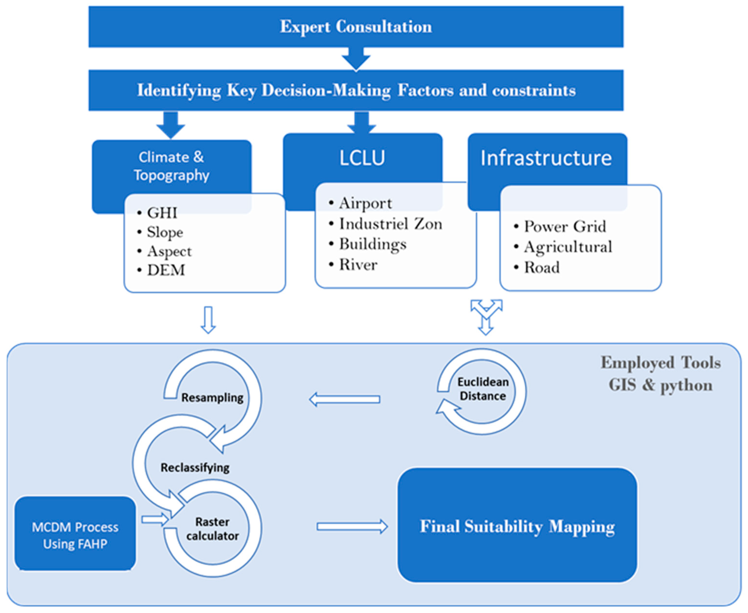
Each layer, representing a criterion in the analysis process, was assigned a specific weight based on its relative importance in determining the suitability of a site for the installation of photovoltaic systems. Each layer received a weight ranging from 0 to 1, where a value of “1” indicated high suitability and the presence of ideal conditions for the installation of photovoltaic systems, while a value of “0” signified unsuitability or the presence of obstacles that prevent the establishment of these systems. These values reflected the balance among the various factors, enabling the identification of locations that provide the best conditions for developing solar energy projects in areas far from the electricity grid. In the final stage, a suitability map was extracted, representing the best options for installing solar energy systems, assisting decision-makers and investors in selecting optimal sites for future project implementation. Figure 2 illustrates the steps taken to conduct the spatial analysis comprehensively.

3.1. Decision Criteria Factors

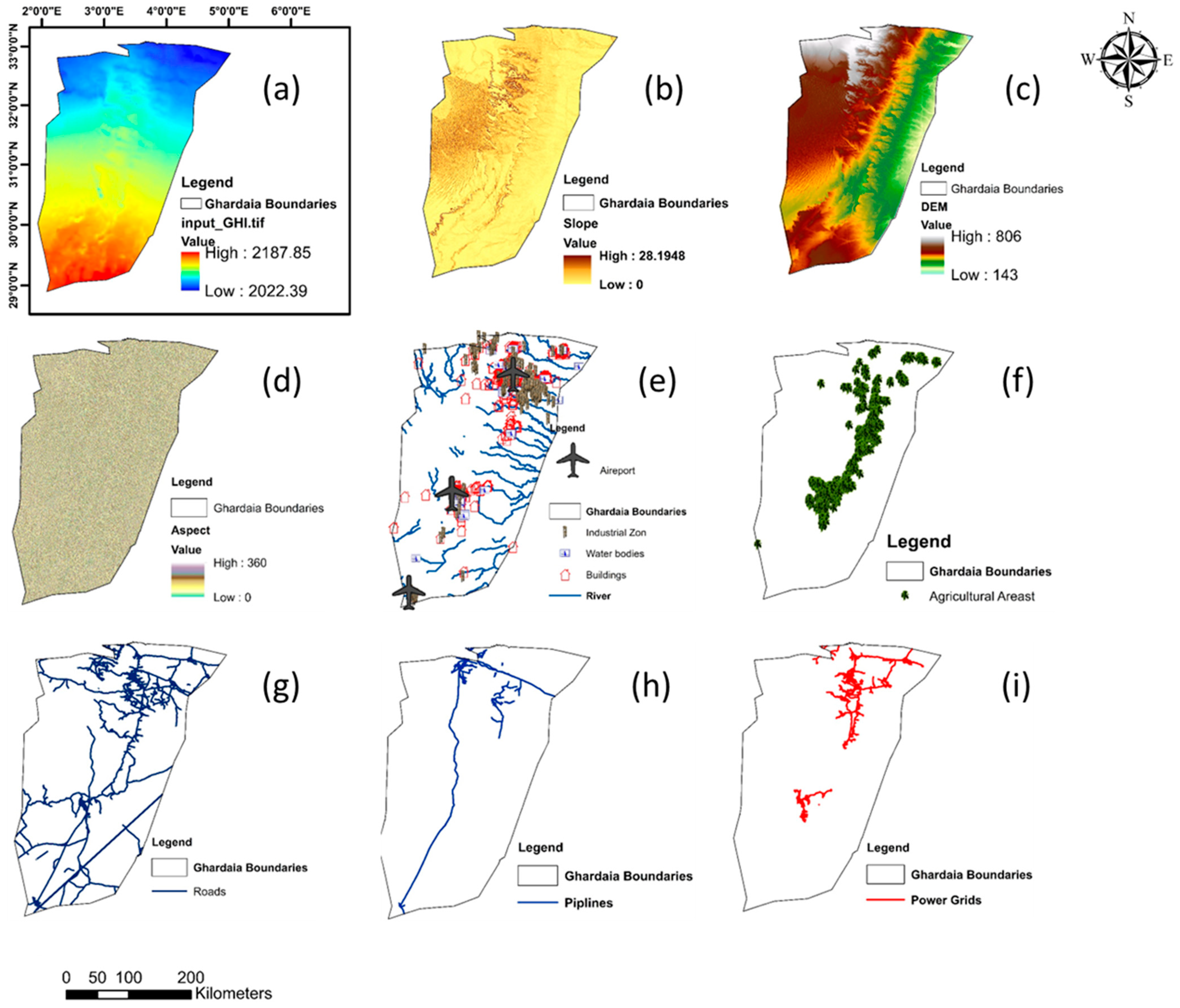
This section outlines the technical, environmental, and geographical data used in the study. These factors, essential to the decision-making process, are visually represented in Figure 3. Their source databases are listed in Table 1, demonstrating their integration and relevance to the site suitability analysis.

3.1.1. Climatic Criteria

Solar irradiance is the primary and decisive factor in selecting the optimal site for establishing a photovoltaic solar energy system, as it is the main source of energy for photovoltaic panels. Therefore, it is essential that the chosen location receives adequate sunlight throughout the year to ensure the system’s efficiency and feasibility. The literature indicates that a photovoltaic energy system typically requires a threshold of 1300 kWh/m2/year to be economically viable [35,36,37]. In the case of the Ghardaïa region, data show that the average solar irradiance exceeds this threshold, as illustrated in Figure 3a. Consequently, Ghardaïa is highly suitable for the installation of photovoltaic solar technology, where high levels of solar energy production can effectively meet anticipated energy demands.

3.1.2. Topography Criteria

Installing photovoltaic solar panels on flat or gently sloping land is crucial to ensure the economic feasibility of solar energy projects. Increased slope affects installation and maintenance costs significantly; the steeper the slope, the greater the need for advanced techniques and additional measures to secure the solar panels and maintain their optimal performance. Steep slopes require more technical work, such as land leveling or terrain modification, which adds complexity to the project and drives up overall costs. Typically, the acceptable threshold for slope suitable for the installation of photovoltaic solar panels is defined between 5 % and 11 % [35,36,38]. In this study, a slope of 11% was considered the maximum for desirable areas, allowing for effective land utilization without incurring additional risks.
Additionally, elevated sites such as mountains can cast shadows on solar panels, negatively impacting the overall efficiency of photovoltaic systems. These shadows result from natural factors like changes in the solar angle throughout the day, making it essential to conduct detailed analyses of the surrounding terrain. Therefore, elevation becomes a crucial factor in site assessment studies for solar panel installation, as it helps identify the most suitable locations that offer sufficient sunlight exposure without subjecting the panels to the risk of terrain-induced shading.
Table 1. Datasets source and description.
ParameterDescriptionsSpatial
Resolution
Time
Period
SourceReference
GHIRaster Data250 m1994–2023Global Solar Atlas (World Bank Group)[39]
SlopeRaster Data30 m2014USGS Earth Explorer[40]
DEMRaster Data30m2014USGS Earth Explorer[40]
AspectRaster Data30m2014USGS Earth Explorer[40]
LULCRaster Data 2022BBBike[41]
Agricultural ZonesPolygon-2022BBBike[41]
PipelinesVector Data-2021Open Street Map[42]
RoadsVector Data-2021Open Street Map[42]
Power GridVector Data-2021Open Street Map[42]

3.1.3. Infrastructure

Infrastructure is a key factor in selecting suitable sites for photovoltaic solar panel installations in agricultural areas, with one of the primary considerations being the proximity of farms to the local power grid. Connecting remote areas to the grid can be costly, imposing a significant financial burden on farmers. As shown in Figure 3i, the electrical network in the Ghardaïa region serves most residential areas, resulting in many agricultural areas being close to the grid. However, there are large expanses of arable land located far from power lines that remain underutilized. These areas have great agricultural potential but would require substantial investment to extend the power grid. Considering these challenges, solar energy becomes a more effective alternative for farmers in remote areas. Moving away from dependence on the traditional electrical grid provides farmers with greater opportunities to adopt solar energy at a lower cost, helping to reduce infrastructure expenses associated with extending power lines. Therefore, sites far from the grid present an ideal opportunity for farmers to implement solar energy projects that meet their needs at a reduced cost, enhance their reliance on renewable energy, support sustainable development, and improve agricultural productivity in these regions.
The selection of solar panel sites is also influenced by their proximity to existing road networks, which reduces transport costs and enhances logistical efficiency, particularly during installation and regular maintenance. During the installation phase, equipment and materials rely heavily on accessible roads, which also facilitates routine maintenance and repairs; easy access minimizes overall operating costs and shortens maintenance-related downtime, improving performance and reducing repair time. Proximity to the road network also speeds up construction by allowing engineering teams and workers to access the site quickly and efficiently, minimizing transport-related delays. In the study, the road network was evaluated, including primary and secondary national highways, as well as unpaved roads that provide additional access, as illustrated in Figure 3g.

3.1.4. Land Use and Land Cover (LULC)

Installing PV solar panels near agricultural and remote areas is essential for providing a reliable electricity source for farmers. However, maintaining an appropriate distance from specific land uses and environmental features is equally important to mitigate the environmental impact of solar installations. When positioned too close to sensitive areas, these projects can have significant environmental repercussions and potentially endanger natural ecosystems. To minimize such risks, spatial exclusion zones are established to identify and exclude unsuitable areas. In this study, a 500 m buffer zone was designated to protect natural reserves, forests, and cultivated lands from potential disturbances.
The Ghardaïa region, a natural gateway for numerous valleys, presents a unique flood risk due to its geography. A 500 m buffer zone surrounded these valleys to protect PV installations from potential flooding, enhancing their resilience against such hazards.
Additionally, a 1000   m exclusion zone was established around nearby airports, along with a 500   m buffer from industrial and petroleum facilities, whose numbers have increased significantly in the area. These buffer zones are essential tools for minimizing operational and environmental risks when selecting suitable PV installation sites, contributing to a safer and more sustainable integration of solar energy infrastructure.

3.2. MCDM Using the Fuzzy AHP Method

Geographic information systems have proven to be an effective tool in enhancing spatial analyses and assessing land suitability for solar power plants, as they enable precise analytical capabilities that support detailed evaluation of geographic and environmental factors. However, relying solely on GIS is not sufficient to determine optimal locations. Numerous studies in the literature review have shown that integrating GIS with MCDM methods forms a powerful and valuable approach for making decisions that involve multiple and complex factors, especially in selecting ideal sites for photovoltaic solar power installations. This integration between GIS and MCDM can improve the accuracy and efficiency of the decision-making process and enhance the reliability of site selection outcomes, as illustrated in recent studies such as [35,43,44,45].
In this study, we employed the FAHP, an advancement of the traditional analytic hierarchy process (AHP) developed by Thomas L. Saaty [46]. AHP, one of the most widely adopted models in multi-criteria decision making (MCDM), has been frequently applied to evaluate site suitability for photovoltaic installations in agricultural regions [18,19], Although AHP has several advantages, it is limited in addressing uncertainties in human preferences, which are often ambiguous and subjective, making them difficult to capture with standard numerical values [47,48].
To address this limitation, Zadeh [49] introduced fuzzy set theory, which incorporates mathematical methods allowing partial membership to manage ambiguity and uncertainty more effectively in decision-making contexts. Due to the robust comparative performance of this fuzzy approach, numerous recent studies [23,50] have continued to employ it extensively.
In FAHP, fixed numerical values used in AHP are replaced by fuzzy numbers, such as triangular or trapezoidal numbers. In this study, we used TFN, as proposed by Van Laarhoven and Pedrycz [51], allowing a more precise representation of human judgments, which may be unclear or uncertain. The expert team consists of five specialists in this field. Their opinions were gathered, and the terms were converted into TFN, as shown in Table 2.
Before detailing the steps for determining the relative weights in F A H P , the fuzzy number M and the membership function of T F N are defined.
The fuzzy number M on the set R is defined by the membership function μ A x R 0   1 , where x A . This number is typically represented in a triangular form l , m , u , where l denotes the lower value, m the middle value, and u the upper value. The membership function of triangular fuzzy numbers is defined as follows:
μ M x = x l m l ,   l x m u l u l ,   m x u 0 ,   o t h e r z i s e
It is worth noting that T F N s have distinct arithmetic operations. When dealing with any two fuzzy numbers, M 1 = l 1 , m 1 , u 1 and M 2 = l 2 , m 2 , u 2 , the following arithmetic operations can be defined [35,52]:
  • Addition of a fuzzy number :
M 1 M 2 = l 1 , m 1 , u 1 l 2 , m 2 , u 2 = l 1 + l 2 , m 1 + m 2 , u 1 + u 2
  • Multiplication of a fuzzy number :
M 1 M 2 = l 1 , m 1 , u 1 l 2 , m 2 , u 2 = l 1 l 2 , m 1 m 2 , u 1 u 2
for l 1 , l 2 > 0 ; m 1 , m 2 > 0 ; u 1 , u 2 > 0
  • Subtraction of a fuzzy number :
M 1 M 2 = l 1 , m 1 , u 1 l 2 , m 2 , u 2 = l 1 l 2 , m 1 m 2 , u 1 u 2
  • Division of a fuzzy number :
M 1 M 2 = l 1 , m 1 , u 1 l 2 , m 2 , u 2 = l 1 / l 2 , m 1 / m 2 , u 1 / u 2
for l 1 , l 2 > 0 ; m 1 , m 2 > 0 ; u 1 , u 2 > 0
  • Reciprocal of a fuzzy number:
M 1 1 = l 1 , m 1 , u 1 1 M 1 1 = 1 / u 1 , 1 / m 1 , 1 / l 1 1
for l 1 > 0 ; m 1 > 0 ; u 1 > 0
Step 1: Form the fuzzy pairwise comparison matrix A ˜ k .
Linguistic terms from the pairwise comparison matrices were converted into T F N s as shown in Table 3. The triangular fuzzy comparison matrix is shown below:
A ˜ k = = a ˜ 11 k a ˜ i j k a ˜ i j k a ˜ 22 k a ˜ 1 n k a ˜ 2 n k a ˜ n 1 k a ˜ n 2 k a ˜ n n k
where a ˜ i j k represents the kth preference of the ith criterion over jth one.
Step 2: Compute the combined matrix of all decision-makers using the equation below.
a ˜ i j = a ˜ i j 1 a ˜ i j 2 . a ˜ i j k k
Following this, the matrix is updated to:
A ˜ = a ˜ i j n x n = 1,1 , 1 l 12 , m 12 , u 12 l 21 , m 21 , u 21 1,1 , 1 l 1 n , m 1 n , u 1 n l 2 n , m 2 n , u 2 n l n 1 , m n 1 , u 1 l n 2 , m n 2 , u n 2 1,1 , 1
where a ˜ i j = l i j , m i j , u i j and a ˜ i j 1 = 1 / u j i , 1 / m j i , 1 / l j i , for i , j = 1 , , n and i j , where a ˜ i n in is a fuzzy pairwise comparison value of criteria i and criteria n .
Step 3: Find the geometric mean of the fuzzy comparison’s values.
To calculate the fuzzy geometric mean of the fuzzy comparisons, we utilized the geometric mean technique introduced by Buckley (1985) [53].
r ˜ i = a ˜ i 1 a ˜ i 2 a ˜ i 3 . . . a ˜ i n 1 / n
r ˜ i denotes the geometric mean of the fuzzy pairwise comparison values between criterion i and all other criteria.
Step 4: Compute the fuzzy weights.
The fuzzy weights for each criterion for are computed as follows, as indicated in Table 3:
w ˜ i = r ˜ i a ˜ i 2 r ˜ 1 r 2 r ˜ 3 . . . r ˜ n 1
w ˜ i   denotes the fuzzy weight of criterion i and is expressed as:
w ˜ i = l w i , m w i , u w i
where l w i , m w i , and u w i represent the lower, middle, and upper values of the fuzzy weight for criterion i , respectively.
Step 5: Use the central area approach for defuzzification.
The defuzzification process utilized the Center of Area approach, which is one of the most prevalent clarification techniques [35]. The best non-fuzzy performance M i value of the fuzzy weight w i was computed as follows:
M i = l w i + m w i + u w i 3
Step 6: Compute the normalized weights.
Once the de-fuzzified weights M i were obtained, they were normalized to produce the final normalized weights.
N i = l w i + m w i + u w i i = 1 n M i
The calculated weights for each criterion are presented in Table 4.
To guarantee the reliability and precision of decision-making, it is critical to evaluate the consistency of the judgments. This ensures that the pairwise comparison matrices in F A H P remain stable and coherent, minimizing the risk of bias and inconsistency.
To confirm the stability of judgments in this study, the eigenvalue method was used, allowing for the calculation of criteria weights by solving the following equations [35].
A w = λ m a x w
A stands for the defuzzified matrix, λ m a x is the maximum eigenvalue, and W is the final weight.
The consistency ratio is represented by C R :
C R = C I R I
where C I   is the consistency index, and R I refers to the random index. The consistency index (CI) is calculated as follows:
C I = λ m a x n n 1
where n refers to the number of criteria.

4. Result and Discussion

This section presents the key findings and provides a thorough analysis of the results based on the employed methodology, focusing on the identification of optimal sites for PV system integration with agricultural activities in remote regions. The analysis is informed by expert consultations and a comprehensive evaluation of relevant data, offering insights to guide decision-making for sustainable energy development in these isolated agricultural areas. The study specifically targets the selection of sites for PV-integrated agricultural systems in regions significantly distant from existing grid infrastructure, aiming to maximize PV efficiency while minimizing logistical challenges and land-use conflicts. Through comprehensive consultations with domain experts—including renewable energy specialists, geospatial analysts, and agricultural planners—the following six factors were employed as critical input data for the decision-making process. Their respective masks were integrated with other remaining factors to generate the final suitability mask for the regions of interest.
  • Power grid accessibility (Power Grid): In remote agricultural regions, PV plants are particularly suitable due to their isolation from major grid infrastructure. However, regions close to power grids already have access to the necessary electricity for operations such as pumping water, thereby reducing the need for extensive PV installations.
  • Farmland availability (Farmland): Assessment of land currently utilized for agriculture to evaluate potential land-use conflicts and prioritize non-agricultural zones.
  • Global solar radiation (Global Solar Radiation): Measurement of solar energy availability, essential for determining PV system efficiency and energy yield.
  • Road infrastructure (Road): Accessibility via existing roads for construction, maintenance, and transportation of PV equipment to remote sites.
  • Slope gradient (Slope): Terrain inclination affecting the ease of PV panel installation and structural stability.
  • Aspect orientation (Aspect): Direction the land faces, influencing solar exposure and optimizing energy capture.
A comprehensive geospatial database was constructed by aggregating spatial and non-spatial data layers corresponding to each identified criterion. The data sources included satellite imagery for accurate mapping of land features and terrain analysis, governmental land-use records to identify existing agricultural zones and land ownership, meteorological data repositories providing detailed information on solar radiation patterns, and infrastructure maps detailing existing road networks and power grid locations. Each criterion was meticulously processed and standardized to ensure consistency and compatibility throughout the analysis phase.
To quantify the relative importance of each criterion, the fuzzy AHP was employed (see Table 2). This methodology effectively manages the inherent uncertainties and subjective judgments associated with expert evaluations.
A pairwise comparison matrix was developed to evaluate the relative importance of each criterion against every other criterion (see Table 3). The matrix utilized TFNs to capture the uncertainty and vagueness in expert judgments. The constructed pairwise comparison matrix encapsulates the relative importance of each criterion in relation to the others. The fuzzy numbers provide a range that accommodates uncertainty and subjectivity inherent in expert judgments.
The lower triangle entries being reciprocals ensure that the matrix remains consistent and reciprocal, a fundamental property in AHP. The weights calculated through the fuzzy AHP technique are summarized in Table 4. Consistency is crucial in AHP to ensure reliable and logical judgments. A consistency ratio (CR) less than 0.10 indicates acceptable consistency.
The calculation of the consistency index (CI) and consistency ratio (CR) involves determining the principal eigenvalue (λmax). First, the weighted sum vector is computed by multiplying each row of the crisp pairwise comparison matrix by the weight vector. Next, for each criterion, λi is calculated as the ratio of the weighted sum to its corresponding weight (λi = weighted sumi/wi). These values are then averaged to obtain λmax. The consistency ratio is calculated as CR = CI/RI = 1.24/0.03 ≈ 0.024. Since CR ≈ 0.024 is less than 0.10, the pairwise comparisons are consistent, ensuring the reliability of the assigned weights.
With the pairwise comparison matrix and the final weights validated for consistency, the next steps involve integrating these weights into the weighted overlay analysis within ArcGIS to generate the final suitability map.
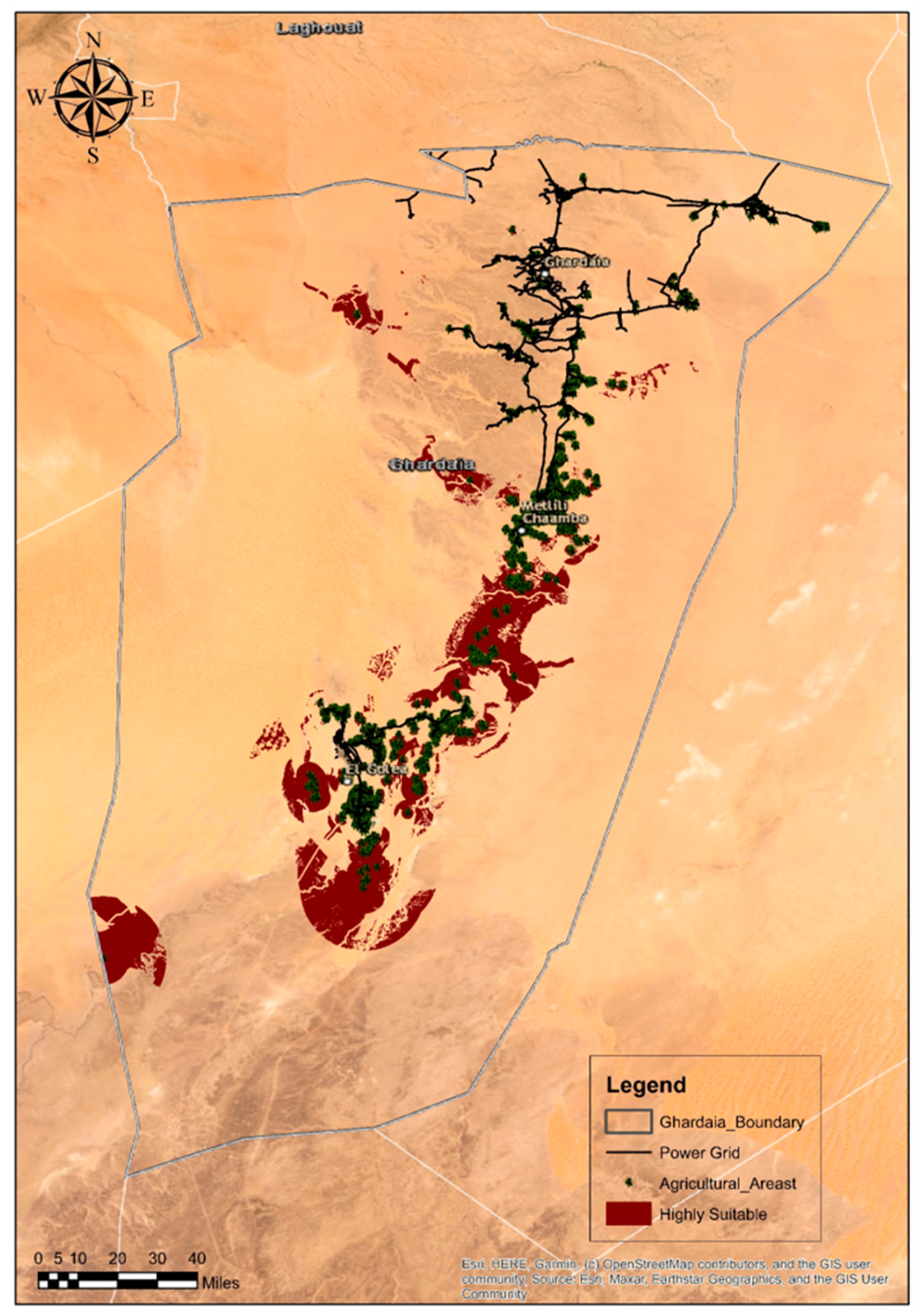
After conducting the fuzzy AHP analysis, the relative importance of each criterion was quantified. The final weights were derived using the fuzzy AHP methodology for this analysis. These weights were subsequently used in the weighted overlay analysis to generate the final suitability map, highlighting areas optimal for photovoltaic–agriculture integration. The final suitability map for photovoltaic–agriculture integration is shown in Figure 4.
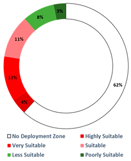
The analysis of the suitability map reveals the distribution of different suitability classes across the Ghardaia region. From the suitability map, the surface area in hectares and the percentage of each class across the entire Ghardaia region are displayed in Table 5. This distribution highlights the areas most conducive to integrating PV plants with agricultural activities, providing a foundation for strategic decision-making in renewable energy deployment.
A substantial 62.36% of the total study area is classified as being within a No Deployment Zone. These regions are deemed unsuitable for PV plant–agriculture integration due to various constraints, which may include:
  • Land use conflicts: Predominant agricultural activities that are incompatible with the installation of PV systems without significant disruption.
  • Environmental protections: Areas designated for conservation, biodiversity, or other ecological reasons that prohibit infrastructure development.
  • Geographical limitations: Terrain or soil conditions unfavorable for both agricultural practices and PV installations, such as extreme slopes or unstable ground.
Collectively, 26.05 % of the study area falls under the Highly Suitable ( 4.14 % ) (see Figure 5), Very Suitable ( 11.70 % ), and Suitable ( 11.21 % ) categories. These regions exhibit favorable conditions for integrating PV plants with agricultural activities, including:
  • Optimal solar radiation: High levels of global solar radiation ensure efficient energy capture and PV system performance, directly benefiting agricultural operations that require reliable power sources.
  • Accessibility: Presence of road infrastructure facilitates the transportation of materials, maintenance activities, and the distribution of agricultural products.
  • Manageable terrain: Suitable slope gradients and favorable aspect orientations enhance the feasibility of co-locating PV panels with farming activities, promoting sustainable land use.
  • High distance from power grids: The significant distance from power grid infrastructure in these remote regions makes them highly suitable for PV plant installations. This high distance reduces the reliance on extending existing energy infrastructure, making localized renewable energy solutions more advantageous and cost-effective for supporting critical agricultural operations such as pumping water.
Less Suitable ( 8.35 % ) and Poorly Suitable ( 3.21 % ) regions indicate areas where PV plant–agriculture integration may be possible, but come with certain limitations:
  • Less Suitable: Moderate levels of solar radiation or logistical challenges, combined with close proximity to power grids that already provide essential electricity for operations such as pumping water, require careful planning and technological adaptations to optimize both energy generation and agricultural productivity.
  • Poorly Suitable: Significant constraints such as low solar potential, difficult terrain, minimal infrastructure support, and the near-distance to power grids that supply sufficient electricity make the integration of PV systems with agricultural activities challenging.
Through these results we find that the use of photovoltaic energy in agricultural areas distant from electrical grids, particularly in desert regions like Ghardaïa in Algeria, provides a promising solution for enhancing agricultural productivity and land reclamation, especially in areas with available groundwater. Solar-powered irrigation systems are particularly well-suited to arid and semi-arid climates, where abundant solar radiation can be harnessed to power irrigation pumps. By utilizing solar energy, these systems significantly improve energy efficiency in regions remote from conventional power networks and lower the operational and maintenance costs typically associated with diesel-powered engines, which are widely used in irrigation systems in these areas.
A study conducted by B. Bouzidi and colleagues in an Algerian desert region environmentally and climatically similar to Ghardaïa confirmed the economic feasibility of a photovoltaic water pumping system (PVWPS) for irrigating date palms. The study observed a significant increase in water use efficiency, from 56% to 86%, when multiple crops were integrated. Additionally, a sensitivity analysis revealed that PVWPS become more economically viable than diesel-powered systems when diesel fuel prices exceed 53.98 Algerian Dinars (DA) per liter, approximately 0.38 euros. This finding suggests that as diesel prices rise above this threshold, PVWPS offer a more cost-effective solution for water pumping needs [54]. Furthermore, studies in Ghardaïa have demonstrated that hybrid systems combining photovoltaic panels with diesel generators can be cost-effective, especially in areas with varying pumping heads. For example, H. Ammar et al. [55] showed that at lower pumping heads (10 m), a diesel system with battery storage was the most cost-effective, while hybrid PV/diesel systems provided greater benefits at higher heads (25 m and 40 m), offering both economic and environmental advantages by reducing emissions.
In the semi-arid region of Sebseb, Ghardaïa, Algeria, researchers S. Boukebbous et al. and N. Benbaha et al., along with their team, implemented a photovoltaic (PV) water pumping system to address the area’s irrigation needs. This system extracts water from a depth of 25 m to meet a daily requirement of 50 cubic meters, utilizing a 1700-watt pump that requires approximately 2759 watt-hours of hydraulic energy per day. To supply this energy, the PV system is configured with a corrected peak power of 2080 watts, accounting for system inefficiencies. The setup comprises 16 PV panels, organized into 4 strings, ensuring efficient energy generation and distribution to meet the system’s operational demands.
Boukabous’s findings showed that seasonal variations significantly impact the performance of photovoltaic solar systems. The study indicated that the system operates optimally during cooler months (winter and spring), but experiences a reduction in efficiency in the summer due to high temperatures [56]. Research by N. Benbaha et al. [57] highlighted that increasing the size of the photovoltaic array by 46% under low solar radiation conditions could improve system efficiency, making solar-powered irrigation a reliable and sustainable solution for desert environments.
Collectively, these studies indicate that while solar-powered systems may require higher initial investments, their long-term economic and environmental advantages make them a superior option over traditional diesel-powered pumps, especially in remote, solar-rich regions like Ghardaïa. These systems reduce operational costs, improve water-use efficiency, and have a lower environmental impact, supporting the sustainable growth of agriculture in desert regions.

5. Conclusions

In light of the achieved results, this study successfully identifies and quantifies the suitability of various regions for integrating PV plants with agricultural activities in remote and isolated agricultural areas. The analysis revealed that 62.36 % of the study area fell under the No Deployment Zone, rendering these regions unsuitable for PV-agriculture integration due to factors such as land use conflicts, environmental protections, and geographical limitations. However, a significant 26.05% of the area was categorized as Highly Suitable ( 4.14 % ), Very Suitable ( 11.70 % ), or Suitable ( 11.21 % ), presenting viable opportunities for renewable energy integration. Integrating PV plants within the Highly Suitable, Very Suitable, and Suitable regions offers substantial benefits for agricultural operations:
  • Efficient irrigation systems: The reliable and consistent energy supply from PV systems enables the operation of advanced water pumping mechanisms. This ensures adequate and timely irrigation, leading to improved crop yields and reduced water wastage.
  • Cold storage facilities: Electrified cold storage units preserve the quality and extend the shelf life of perishable agricultural products. This minimizes post-harvest losses and enhances the marketability of produce, thereby supporting local economies.
  • On-site processing units: Reliable power facilitates the establishment of on-site processing facilities, adding value to agricultural products and reducing transportation costs. This integration promotes local processing capabilities, enhancing overall agricultural productivity.
The integration of PV plants with remote agricultural regions represents a transformative approach to enhancing agricultural activities and ensuring food safety in isolated areas. By leveraging renewable energy sources, these regions can achieve sustainable development, economic growth, and environmental stewardship. The study underscores the critical role of strategic planning and stakeholder engagement in realizing the full potential of PV–agriculture integration, ultimately contributing to the resilience and prosperity of isolated agricultural communities.

Author Contributions

Conceptualization, methodology, Data resources, writing—original draft preparation A.B. and M.G.; writing—review and editing, R.K. and T.A.; formal analysis, T.C. and A.R.; writing—review and editing, E.-S.M.E.-K.; funding acquisition, A.A.A. All authors have read and agreed to the published version of the manuscript.

Funding

This project has been funded by Princess Nourah bint Abdulrahman University Researchers Supporting Project number (PNURSP2024R308), Princess Nourah bint Abdulrahman University, Riyadh, Saudi Arabia.

Data Availability Statement

The raw data supporting the conclusions of this article will be made available by the authors on request.

Acknowledgments

Princess Nourah bint Abdulrahman University Researchers Supporting Project number (PNURSP2024R308), Princess Nourah bint Abdulrahman University, Riyadh, Saudi Arabia. The authors gratefully acknowledge the support provided by the General Directorate of Scientific Research and Technological Development (DGRSDT), Ministry of Higher Education and Scientific Research (MESRS), Algeria.

Conflicts of Interest

The authors declare no conflicts of interest.

Nomenclature

AHPAnalytical Hierarchy Process
CIConsistency’s value Index
CRConsistency Ratio
FAHPFuzzy Analytical Hierarchy Process
FBWMFuzzy Best-Worst Method
GISGeographical Information System
GHIGlobal Solar Radiation.
llower value
mmiddle value
MCDMMulti-Criteria Decision Making
MFuzzy Number
NNumber of criteria
PVPhotovoltaic
PVWPSPhotovoltaic Water Pumping Systems
uupper value
RIRandom Consistency Index
TFNTriangular Fuzzy Numbers
WFinal Weight
SPISpowered irrigation systems
λmaxMaximum eigenvalue.
μ M Membership function of triangular fuzzy numbers

References

  1. Taghizadeh-Hesary, F.; Rasoulinezhad, E.; Yoshino, N. Energy and Food Security: Linkages through Price Volatility. Energy Policy 2019, 128, 796–806. [Google Scholar] [CrossRef]
  2. Sarkar, N.I.; Ghosh, H.R. Techno-economic analysis and challenges of solar powered pumps dissemination in Bangladesh. Sustain. Energy Technol. Assess. 2017, 20, 33–46. [Google Scholar] [CrossRef]
  3. Guo, J.; Tanaka, T. Energy security versus food security: An analysis of fuel ethanol-related markets using the spillover index and partial wavelet coherence approaches. Energy Econ. 2022, 112, 106142. [Google Scholar] [CrossRef]
  4. Palazzo, A.; Kahil, T.; Willaarts, B.A.; Burek, P.; van Dijk, M.; Tang, T.; Magnuszewski, P.; Havlík, P.; Langan, S.; Wada, Y. Assessing sustainable development pathways for water, food, and energy security in a transboundary river basin. Environ. Dev. 2024, 51, 101030. [Google Scholar] [CrossRef]
  5. Campana, P.; Leduc, S.; Kim, M.; Olsson, A.; Zhang, J.; Liu, J.; Kraxner, F.; McCallum, I.; Li, H.; Yan, J. Suitable and optimal locations for implementing photovoltaic water pumping systems for grassland irrigation in China. Appl. Energy 2017, 185, 1879–1889. [Google Scholar] [CrossRef]
  6. García, A.M.; Gallagher, J.; McNabola, A.; Poyato, E.C.; Barrios, P.M.; Díaz, J.R. Comparing the environmental and economic impacts of on- or off-grid solar photovoltaics with traditional energy sources for rural irrigation systems. Renew. Energy 2019, 140, 895–904. [Google Scholar] [CrossRef]
  7. Rana, M.J.; Kamruzzaman, M.; Oliver, M.M.H.; Akhi, K. Influencing factors of adopting solar irrigation technology and its impact on farmers’ livelihood. A case study in Bangladesh. Futur. Food J. Food Agric. Soc. 2021, 9, 5. [Google Scholar] [CrossRef]
  8. Sunny, F.A.; Islam, M.A.; Karimanzira, T.T.P.; Lan, J.; Rahman, S.; Zuhui, H. Adoption impact of solar based irrigation facility by water-scarce northwestern areas farmers in Bangladesh: Evidence from panel data analysis. Front. Energy Res. 2023, 10, 1101404. [Google Scholar] [CrossRef]
  9. Khan, N.; Xu, X.; Ahsan, F. Solar empowerment in agriculture: Investigating photovoltaic energy’s impact on efficiency among wheat farmers. Front. Sustain. Food Syst. 2024, 8, 1426538. [Google Scholar] [CrossRef]
  10. Khan, N.; Elhindi, K.M.; Kassem, H.S.; Kazim, R.; Zhang, S. Unveiling the nexus between solar energy adoption and crop farmer income: Evidence from Pakistan. Front. Sustain. Food Syst. 2024, 8, 1364040. [Google Scholar] [CrossRef]
  11. Maity, R.; Sudhakar, K.; Razak, A.A. Agri-solar water pumping design, energy, and environmental analysis: A comprehensive study in tropical humid climate. Heliyon 2024, 10, e39604. [Google Scholar] [CrossRef] [PubMed]
  12. Mishra, A.K.; Sudarsan, J.; Suribabu, C.; Murali, G. Cost-benefit analysis of implementing a solar powered water pumping system—A case study. Energy Nexus 2024, 16, 100323. [Google Scholar] [CrossRef]
  13. Terang, B.; Baruah, D.C. Techno-economic and environmental assessment of solar photovoltaic, diesel, and electric water pumps for irrigation in Assam, India. Energy Policy 2023, 183, 113807. [Google Scholar] [CrossRef]
  14. Okakwu, I.; Alayande, A.; Akinyele, D.; Olabode, O.; Akinyemi, J. Effects of total system head and solar radiation on the techno-economics of PV groundwater pumping irrigation system for sustainable agricultural production. Sci. Afr. 2022, 16, e01118. [Google Scholar] [CrossRef]
  15. Hassan, W.; Kamran, F. A hybrid PV/utility powered irrigation water pumping system for rural agricultural areas. Cogent Eng. 2018, 5, 1466383. [Google Scholar] [CrossRef]
  16. Carroquino, J.; Dufo-López, R.; Bernal-Agustín, J.L. Sizing of off-grid renewable energy systems for drip irrigation in Mediterranean crops. Renew. Energy 2015, 76, 566–574. [Google Scholar] [CrossRef]
  17. Chandel, S.; Naik, M.N.; Chandel, R. Review of solar photovoltaic water pumping system technology for irrigation and community drinking water supplies. Renew. Sustain. Energy Rev. 2015, 49, 1084–1099. [Google Scholar] [CrossRef]
  18. Rubio-Aliaga, A.; García-Cascales, M.S.; Sánchez-Lozano, J.M.; Molina-Garcia, A. MCDM-based multidimensional approach for selection of optimal groundwater pumping systems: Design and case example. Renew. Energy 2021, 163, 213–224. [Google Scholar] [CrossRef]
  19. Ammar, H.; Boukebbous, S.E.; Benbaha, N. Photovoltaic Water Pumping System Site Suitability Analysis Using AHP GIS method in Southern Algeria. In Proceedings of the 2018 4th International Conference on Renewable Energies for Developing Countries (REDEC), Beirut, Lebanon, 1–2 November 2018; pp. 1–5. [Google Scholar]
  20. Ammar, H.; Benbaha, N.; Boukebbous, S.E. Siting analysis of PV Water Pumping System Using GIS-Based fuzzy Analytic Hierarchy Process. In Proceedings of the 2019 4th International Conference on Power Electronics and their Applications (ICPEA), Elazig, Turkey, 25–27 September 2019; pp. 1–5. [Google Scholar]
  21. Minaei, F.; Minaei, M.; Kougias, I.; Shafizadeh-Moghadam, H.; Hosseini, S.A. Rural electrification in protected areas: A spatial assessment of solar photovoltaic suitability using the fuzzy best worst method. Renew. Energy 2021, 176, 334–345. [Google Scholar] [CrossRef]
  22. García-Cascales, M.; Molina-García, A.; Sánchez-Lozano, J.; Mateo-Aroca, A.; Munier, N. Multi-criteria analysis techniques to enhance sustainability of water pumping irrigation. Energy Rep. 2021, 7, 4623–4632. [Google Scholar] [CrossRef]
  23. Saqr, A.M.; Nasr, M.; Fujii, M.; Yoshimura, C.; Ibrahim, M.G. Delineating suitable zones for solar-based groundwater exploitation using multi-criteria analysis: A techno-economic assessment for meeting sustainable development goals (SDGs). Groundw. Sustain. Dev. 2024, 25, 101087. [Google Scholar] [CrossRef]
  24. Dere, S.; Günay, E.E.; Kula, U.; Kremer, G.E. Assessing agrivoltaics potential in Türkiye—A geographical information system (GIS)-based fuzzy multi-criteria decision making (MCDM) approach. Comput. Ind. Eng. 2024, 197, 110598. [Google Scholar] [CrossRef]
  25. FAO. Algeria|Family Farming Knowledge Platform|Food and Agriculture Organization of the United Nations. Available online: https://www.fao.org/family-farming/countries/dza/en/ (accessed on 27 October 2024).
  26. Debbabi, S.; Bouteche, B. For a Sustainable Use of Agricultural Land in Constantine (Algeria). In Proceedings of the 8th International Conference of Contemporary Affairs in Architecture and Urbanism, Istanbul, Turkey, 14–15 June 2023; pp. 14–15. [Google Scholar] [CrossRef]
  27. Khezzani, B.; Bouchemal, S. Variations in groundwater levels and quality due to agricultural over-exploitation in an arid environment: The phreatic aquifer of the Souf oasis (Algerian Sahara). Environ. Earth Sci. 2018, 77, 142. [Google Scholar] [CrossRef]
  28. Choi, C.S.; Ravi, S.; Siregar, I.Z.; Dwiyanti, F.G.; Macknick, J.; Elchinger, M.; Davatzes, N.C. Combined land use of solar infrastructure and agriculture for socioeconomic and environmental co-benefits in the tropics. Renew. Sustain. Energy Rev. 2021, 151, 111610. [Google Scholar] [CrossRef]
  29. Mirembe, A.; Nakiirya, R.; Kansiime, M.K. Demonstration of the potential use of off-grid renewable energy in agricultural production in rural Uganda. Open Res. Eur. 2024, 4, 150. [Google Scholar] [CrossRef]
  30. Guermoui, M.; Fezzani, A.; Mohamed, Z.; Rabehi, A.; Ferkous, K.; Bailek, N.; Bouallit, S.; Riche, A.; Bajaj, M.; Mohammadi, S.A.D.; et al. An analysis of case studies for advancing photovoltaic power forecasting through multi-scale fusion techniques. Sci. Rep. 2024, 14, 6653. [Google Scholar] [CrossRef] [PubMed]
  31. Guermoui, M.; Arrif, T.; Belaid, A.; Hassani, S.; Bailek, N. Enhancing direct Normal solar Irradiation forecasting for heliostat field applications through a novel hybrid model. Energy Convers. Manag. 2024, 304, 118189. [Google Scholar] [CrossRef]
  32. Journal Officiel of the People’s Democratic Republic of Algeria. Decree Published on 21 March 2021. Available online: https://www.joradp.dz/JRN/ZF2021.htm?zAnn=2021 (accessed on 16 November 2024).
  33. UNESCO. M’Zab Valley—UNESCO World Heritage Centre. Available online: https://whc.unesco.org/en/list/188/ (accessed on 27 October 2024).
  34. Gairaa, K.; Khellaf, A.; Benkacilai, S.; Guermoui, M. Solar radiation measurements in Algeria: Case of Ghardaïa station as member of the enerMENA meteorological network. Energy Procedia 2017, 141, 50–54. [Google Scholar] [CrossRef]
  35. Rekik, S.; El Alimi, S. A GIS based MCDM modelling approach for evaluating large-scale solar PV installation in Tunisia. Energy Rep. 2024, 11, 580–596. [Google Scholar] [CrossRef]
  36. Elboshy, B.; Alwetaishi, M.; Aly, R.M.H.; Zalhaf, A.S. A suitability mapping for the PV solar farms in Egypt based on GIS-AHP to optimize multi-criteria feasibility. Ain Shams Eng. J. 2022, 13, 101618. [Google Scholar] [CrossRef]
  37. Effat, H.A.; El-Zeiny, A.M. Geospatial modeling for selection of optimum sites for hybrid solar-wind energy in Assiut Governorate, Egypt. Egypt. J. Remote Sens. Space Sci. 2022, 25, 627–637. [Google Scholar] [CrossRef]
  38. Prieto-Amparán, J.A.; Pinedo-Alvarez, A.; Morales-Nieto, C.R.; Valles-Aragón, M.C.; Álvarez-Holguín, A.; Villarreal-Guerrero, F. A Regional GIS-Assisted Multi-Criteria Evaluation of Site-Suitability for the Development of Solar Farms. Land 2021, 10, 217. [Google Scholar] [CrossRef]
  39. Atlas, G.S. Global Solar Atlas. Available online: https://globalsolaratlas.info/download/algeria (accessed on 5 October 2024).
  40. USGS (United States Geological Survey). Available online: https://earthexplorer.usgs.gov (accessed on 11 November 2024).
  41. BBBike Extracts Ready to Download. Available online: https://download.bbbike.org/osm/extract/ (accessed on 11 November 2024).
  42. OpenStreetMap Project. Available online: https://www.openstreetmap.org/ (accessed on 11 November 2024).
  43. Hamad, J.; Ahmad, M.; Zeeshan, M. Solar energy resource mapping, site suitability and techno-economic feasibility analysis for utility scale photovoltaic power plants in Afghanistan. Energy Convers. Manag. 2024, 303, 118188. [Google Scholar] [CrossRef]
  44. Hasanzaeh, M.; Kamran, K.V.; Feizizadeh, B.; Mollabashi, S.H. Land suitability analysis for solar power plant using satellite imagery processing and GIS, Ardabil, Iran. Int. J. Eng. Geosci. 2023, 9, 115–130. [Google Scholar] [CrossRef]
  45. Günen, M.A. A comprehensive framework based on GIS-AHP for the installation of solar PV farms in Kahramanmaraş, Turkey. Renew. Energy 2021, 178, 212–225. [Google Scholar] [CrossRef]
  46. Dubois, D.; Prade, H. Fuzzy sets and systems theory and applications. In Mathematics in Science and Engineering; Academic Press, Inc.: Chestnut Hill, MA, USA, 1980; Volume 144, pp. 1–333. [Google Scholar]
  47. Khashei-Siuki, A.; Keshavarz, A.; Sharifan, H. Comparison of AHP and FAHP methods in determining suitable areas for drinking water harvesting in Birjand aquifer. Iran. Groundw. Sustain. Dev. 2020, 10, 100328. [Google Scholar] [CrossRef]
  48. Choudhary, D.; Shankar, R. An STEEP-fuzzy AHP-TOPSIS framework for evaluation and selection of thermal power plant location: A case study from India. Energy 2012, 42, 510–521. [Google Scholar] [CrossRef]
  49. Zadeh, L.A. Fuzzy Sets. Inf. Control 1965, 8, 338–353. [Google Scholar] [CrossRef]
  50. Rengma, N.S.; Yadav, M.; Kishor, N. Solar photovoltaic water pumping system: A software tool development-based optimal configuration investigation for system installation location, sizing and deployment. Renew. Energy Focus 2023, 46, 236–255. [Google Scholar] [CrossRef]
  51. van Laarhoven, P.J.M.; Pedrycz, W. A fuzzy extension of Saaty’s priority theory. Fuzzy Sets Syst. 1983, 11, 229–241. [Google Scholar] [CrossRef]
  52. Xue, L.; Cao, P.; Xu, D.; Guo, Y.; Wang, Q.; Zheng, X.; Han, R.; You, A. Agricultural land suitability analysis for an integrated rice–crayfish culture using a fuzzy AHP and GIS in central China. Ecol. Indic. 2023, 148, 109837. [Google Scholar] [CrossRef]
  53. Buckley, J.J. Fuzzy hierarchical analysis. Fuzzy Sets Syst. 1985, 17, 233–247. [Google Scholar] [CrossRef]
  54. Bouzidi, B.; Campana, P.E. Optimization of photovoltaic water pumping systems for date palm irrigation in the Saharan regions of Algeria: Increasing economic viability with multiple-crop irrigation. Energy Ecol. Environ. 2021, 6, 316–343. [Google Scholar] [CrossRef]
  55. Ammar, M.A.H.; Melit, A.; Bouziane, M.T. Optimizing Pumping Systems; Hydraulic Inst: Parsippany, NJ, USA, 2015. [Google Scholar]
  56. Boukebbous, S.E.; Benbaha, N.; Bouchakour, A.; Ammar, H.; Bouhoun, S.; Kerdoun, D. Experimental performance assessment of photovoltaic water pumping system for agricultural irrigation in semi-arid environment of Sebseb—Ghardaia, Algeria. Int. J. Energy Environ. Eng. 2022, 13, 979–994. [Google Scholar] [CrossRef]
  57. Benbaha, N.; Zidani, F.; Bouchakour, A.; Boukebbous, S.E.; Nait-Said, M.S.; Ammar, H.; Bouhoun, S. Optimal Configuration Investigation for Photovoltaic Water Pumping System, Case Study: In a Desert Environment at Ghardaia, Algeria. J. Eur. des Syst. Autom. 2021, 54, 549–558. [Google Scholar] [CrossRef]
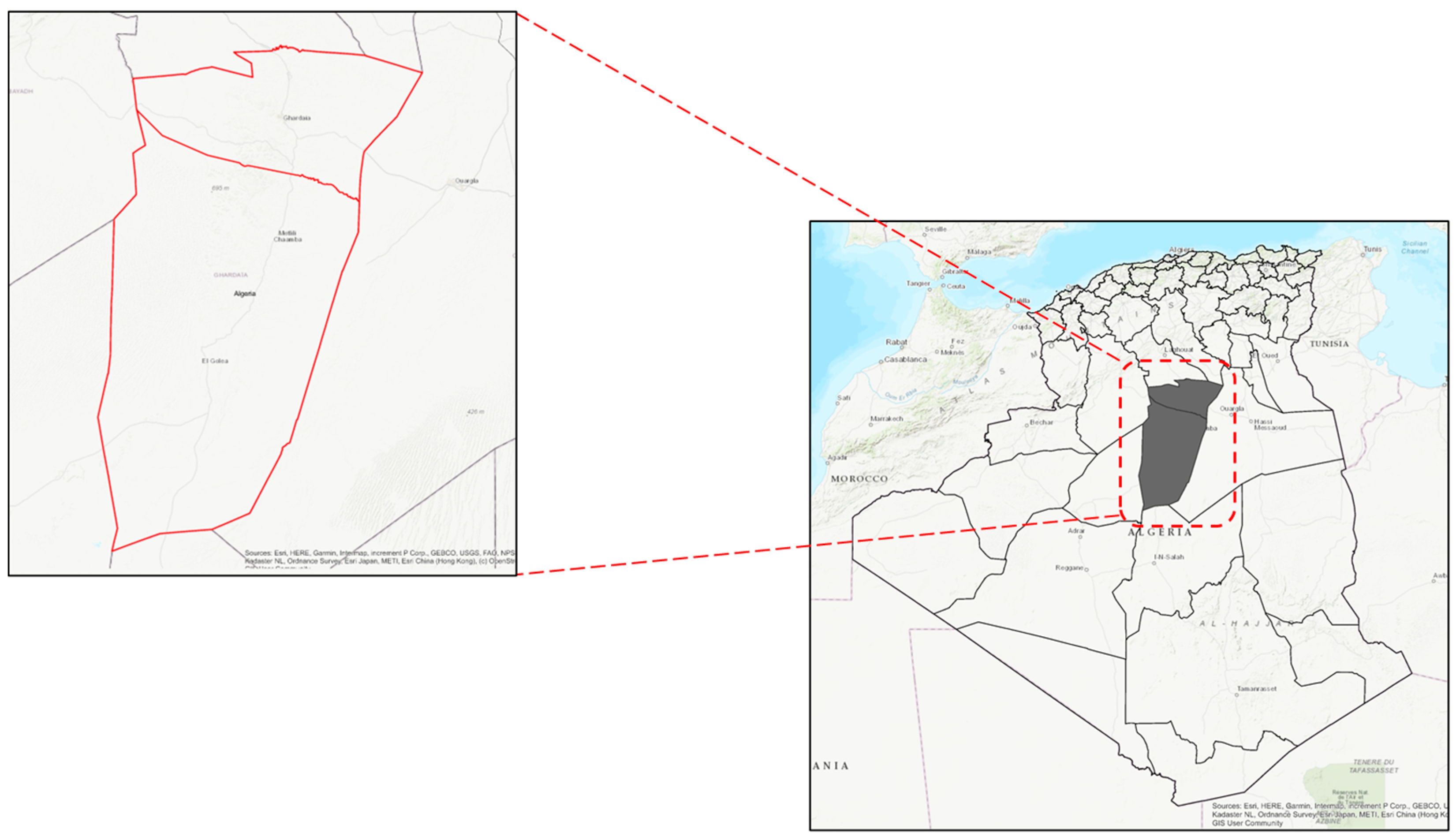
Figure 1. Study area map: Ghardaïa City.
Energies 17 05792 g001
Figure 2. Flowchart of the methodology.
Energies 17 05792 g002
Figure 3. Overview maps for all evaluation criteria. (a) GHI; (b) slope; (c) DEM; (d) aspect; (e) LULC; (f) agricultural zones; (g) pipelines; (h) roads; (i) power grid.
Energies 17 05792 g003
Figure 4. Suitability map for photovoltaic-agriculture.
Energies 17 05792 g004
Figure 5. High suitability map for photovoltaic–agriculture integration.
Energies 17 05792 g005
Table 2. The decision criteria used in this study.
TFN ScaleDefinition
(1,1,1)Indicates equal importance between the two criteria.
(1,2,3)Suggests that the row criterion is Slightly More Important than the
column criterion.
(3,4,5)Reflects a Moderately More Important relationship.
(5,6,7)Denotes a Strongly More Important relationship.
(7,8,9)Represents a Very Strongly More Important relationship.
Table 3. Pairwise comparison matrix.
CriteriaPower GridFarmlandGHIRoadSlopeAspect
Power Grid(1,1,1)(1,2,3)(3,4,5)(3,4,5)(5,6,7)(7,8,9)
Farmland(1/3,1/2,1)(1,1,1)(1,2,3)(3, 4, 5)(3,4,5)(5,6,7)
GHI(1/5,1/4,1/3)(1/3,1/2,1)(1,1,1)(1,2,3)(1,2,3)(3,4,5)
Road(1/5,1/3,1/4)(1/5,1/4,1/3)(1/3,1/2,1)(1,1,1)(1,2,3)(3,4,5)
Slope(1/7,1/6,1/5)(1/5,1/4,1/3)(1/3,1/2,1)(1/3,1/2,1)(1,1,1)(1,2,3)
Aspect(1/9,1/8,1/7)(1/7,1/6,1/5)(1/5,1/4,1/3)(1/5,1/4,1/3)(1/3,1/2,1)(1,1,1)
Table 4. Normalized weights.
CriterionPower GridFarmlandGHIRoadSlopeAspectSum
Weight0.350.250.130.120.100.071.00
Table 5. Percentage distribution of suitability for photovoltaic–agriculture integration.
ClassSuitability ClassSurface Area (ha)Energies 17 05792 i001
1No Deployment Zone5,212,734.10
2Highly Suitable346,673.30
3Very Suitable977,606.84
4Suitable937,385.97
5Less Suitable697,156.09
6Poorly Suitable268,680.62
Total8,364,072.03
Disclaimer/Publisher’s Note: The statements, opinions and data contained in all publications are solely those of the individual author(s) and contributor(s) and not of MDPI and/or the editor(s). MDPI and/or the editor(s) disclaim responsibility for any injury to people or property resulting from any ideas, methods, instructions or products referred to in the content.