Article

Populus simonii Carr. Reduces Wind Erosion and Improves Soil Properties in Northern China

Key Laboratory of Soil and Water Conservation and Desertification Combating of the Ministry of Education, Beijing Forestry University, Beijing 100083, China
*
Author to whom correspondence should be addressed.
Forests 2019, 10(4), 315; https://doi.org/10.3390/f10040315
Submission received: 11 March 2019 / Revised: 2 April 2019 / Accepted: 2 April 2019 / Published: 6 April 2019
(This article belongs to the Section Forest Ecology and Management)

Abstract

:
To assess the ecological effects of poplar stands with different densities and ages, fixed observation sites were established in selected standard forest plots. Daily dynamics of wind speed and sand transport rate were monitored over an erosive period (March to June) in 2017. Soil characteristics were also measured at these plots. Average daily wind speed and average daily wind erosion modulus decreased significantly after the establishment of poplar trees on sandy land, while soil density decreased significantly, soil hardness increased greatly, and soil organic carbon, total N, and available P levels increased significantly. With increasing stand density, average daily wind speed and daily sediment transport firstly decreased and then increased, while the investigated soil nutrients showed the opposite trend. A tree density of 1320–1368 trees·hm−2 significantly reduced surface wind erosion. With the increase in forest age, the average daily wind speed and daily sediment transport declined, while soil physical and chemical properties were gradually improved. At a stand age of 40 years, wind-caused soil erosion significantly reduced. Taking these effects into consideration, the design and management of protective forest systems in arid and semi-arid areas can be greatly improved.

1. Introduction

Land degradation as a result of wind erosion is one of the most important ecological problems in arid and semi-arid regions, which cover 41% of the global land area, posing an increasing threat to global biochemical cycles and agricultural productivity, and facilitating human health hazards and climate change [1,2,3]. China is particularly susceptible to land degradation by wind erosion, where almost 40% of the national territory and over 170 million residents are threatened by wind erosion [4]. Land degradation by wind erosion occurs widely in northwest China, where low annual precipitation and frequent strong winds prevail [1].
To mitigate this problem, the Chinese government implemented a variety of measures that led to significant achievements in curbing the effects of land degradation on the environment and human life in some affected regions [5,6]; however, not all assessments agree about how effective these measures are, specifically in preventing wind erosion and dust storms [7,8]. Poplars are used as shelterbelts in many other parts of the world, such as Canada [9] and Russia [10]. Sand-fixing and windbreak forests are widely used to improve the local ecological conditions in arid and semi-arid regions [11,12] and are the main components of the Three-North Shelterbelt Project, known as the “Green Great Wall” of China [13,14,15]. As part of the project, some sandy land in the Zhangbei area was afforested with poplar (Populus simonii Carr.) shelterbelts in the past 40 years. In the early stage of afforestation, due to the lack of field experimental data in terms of vegetation structure and function, local governments carried out afforestation with the fundamental starting point of increasing the number of trees and shortening afforestation periods on sandy land. In addition, because of the large size of the project, it was subdivided into different stages. As a result, large amounts of sand-fixing poplars, at different densities and ages, were established in the Zhangbei area.
A full understanding of the wind erosion characteristics is essential to arrange and manage sand-fixing and windbreak forests [16,17,18,19,20]. However, studies of land degradation by wind erosion are generally conducted on farmland, deserts, or highly disturbed locations, with considerable challenges [21]. In this sense, until recently, wind erosion across forest ecosystems was hardly investigated.
The spacing and shape of woody plants determine the spatial density of roughness elements, which may in turn affect wind erosion [21,22,23]. Numerous studies indicated that wind erosion could be alleviated through shelterbelts; nevertheless, studies on wind erosion under different shelterbelt structures, especially at different density structures and age levels, are rare [1,10,24,25].
In this context, to address this knowledge gap, some basic questions still remain to be answered. Firstly, how do forests on sandy land affect wind speed, surface erosion, and soil improvement compared to non-forested sandy land? Secondly, to which extent do such forests of different densities and ages affect wind speed, surface erosion, and soil improvement? Thirdly, when establishing shelterbelts for sand fixation, which tree density is appropriate? By answering these questions, we can provide important information for regional and national policy-makers to make reasonable decisions to further combat land degradation by wind erosion in the fragile arid regions of China.

2. Materials and Methods

2.1. Experimental Site

The experimental site was located in Zhangbei County, Hebei Province, on the southern edge of the Inner Mongolia plateau in northern China, between 40° 57′ north (N) and 41° 34′ N and between 114° 10′ E and 115° 27′ E (Figure 1). Average elevation is 1300 m above sea level. The climate is mid-latitude temperate monsoon climate, with obvious continental characteristics. Average annual temperature is 3.2 °C, with an annual precipitation of about 300 mm, of which 70.8% occurs from June to August. Both precipitation and temperature show a high inter-annual variation. Evaporation is four times greater than precipitation, with a drying degree of 1.50–2.20 and sunshine hours of 2898 h each year. For most of the year, this area is under the control of the Mongolian high pressure, and the terrain is open and flat with an annual average wind speed of 3.9 m·s−1. Furthermore, the prevailing winds are northwest and southwest in the winter and spring, averaging 4.1 m·s−1, to south in the summer and autumn during the growing season, averaging 3.1 m·s−1. Dust events occur most frequently in spring, with an accumulated time of more than 1440 h per year. The original vegetation in the area was Carex lanceolata Boott, Potentilla chinensis Ser, and Rumex patientia Linn, with sparsely scattered trees (mainly Ulmus pumila).

2.2. Experimental Design

Six poplar forests with different densities and six poplar forests with different ages were selected for this study, while a parcel of sandy land without protective forest cover was used as control. These forests were planted since 1978, with the main purpose of breaking the wind and fixing the sandy underground. Prior to the establishment of these forests, the area was a sandy area with severe wind erosion. The size of the experimental sites was 100 × 100 m, with a rectangular shape. Importantly, each site was unobstructed in the upper wind direction of the prevailing northwestern wind within 200 m, and the part between parcels was bare land. The basic conditions of the fields are shown in Table 1.
To quantify the effects of different poplar forests in soil improvement, daily wind speed dynamics, wind and sand transport efficiency, and soil characteristics were studied quantitatively by using fixed observation sites located inside the forest stands, located in the center of each site. Additionally, one observation site was set up on sandy land with a wind direction of about 1000 m above the forest edge toward the northwest and used as a control site (CK), representing the initial conditions before the establishment of poplar forests.

2.3. Measurements of Wind Speed and Sand Transport

For each experimental site, the transport rate of sand by wind was measured over an erosive period from March through May in 2017 with five traps. The traps consisted of cylindrical enamel containers with a diameter of 30 cm and a height of 15 cm. To facilitate sediment collection, we used thick galvanized iron sheets to make an additional container (slightly larger than the size of the trap) as the bracket for the catcher. Firstly, we buried the bracket in the soil (the upper edge of the bracket was about 1 cm above the ground) and subsequently placed the trap into the bay. Each day, at a fixed time, we removed the trap from the scaffold, extracted the sediment with a brush, and then returned the trap to the scaffold for the following measurement. To avoid the loss of dry sand due to turbulence effects, we added small gravel blocks with a diameter of 2 cm to the trap, covering the entire bottom of the trap. The results of repeated comparison tests showed that the sand mining volume obtained by the gravel cover method (dry method) was only 3% lower than that obtained with the water method (hydrometallurgy). For this reason, the efficiency of this method can exceed 90%. The collected sediment was weighed with an electronic balance, and the sediment transport rate was expressed as the amount of silt collected daily per unit area. The sketch map of a trap in the field site is shown in Figure 2.
Wind velocity and direction were measured using PC–2F multi-channel auto-count telemetry (Jinzhou Sunshine Technology Development Co. Ltd., Jinzhou, China). The anemometer sensor was mounted at a height of 2.0 m to measure wind speed, while a wind direction sensor was mounted at a height of 5 m for the determination of the wind direction (only at the CK site). Data were collected at intervals of 1 min, and the mean daily wind speeds at different heights at the 13 observation points were calculated.

2.4. Measurements of Soil Properties

Soil sampling was carried out in August 2017. For each site, three replicated soil samples were collected from the upper 5 cm. All samples were sieved to pass a 2-mm mesh, and roots and other debris were removed and discarded. Soil particle size distribution was determined by the dry sieve method, using 0.02-, 0.2-, and 2.0-mm mesh sieves. Three samples were also taken from each site with stainless-steel soil ring kits (100 cm3) to measure bulk density. Soil surface hardness was measured with a hardness meter (Yamanaka–07202301, Fujiwara Scientific Co. Ltd., Tokyo, Japan), while organic carbon was determined using the dichromate wet combustion method. Total N was determined using the Kjeldahl method (DK Heating Digester, UDK140 Automatic Steam Distilling Unit, Titroline 96, Italy), and available P was determined by the Bray method.

2.5. Data Analysis

The data were processed using Sigmaplot 12.0 and SPSS 19.0. To rule out the impact of wind direction, only 25 days of northwest (NW) wind (spring main wind) were selected for 60 days from April to May [1,6,7]. The differences in daily mean wind speed, daily wind sediment transport rate, daily dust transfer rate, and soil and vegetation parameters were tested by analysis of variance (ANOVA) and Fisher’s least significant difference (LSD), using the statistical software package SPSS; significance was set at 5%.
To quantitatively evaluate the wind resistance effects of poplar forests with different ages and densities, the wind speed attenuation index (AI) was calculated using the following formula, which denotes the attenuation percentage of wind speed to CK at different observation points:
AI = (Vck − Vos)⁄Vck × 100%,
where AI is the attenuation index of wind speed, which reflects the relative reduction of wind speed, Vck is the daily average wind speed at a height of 2 m in the CK site, and Vos is the daily average wind speed at a height of 2 m in the forest stands. Higher AI values generally correspond to a higher wind resistance.
Similarly, to assess the impacts of the forest stands against wind erosion, the reduction of the ground wind erosion index was calculated on the basis of the following formula, which denotes the percentage of sediment transport rate at different observation points relative to the control:
DI = (Qck − Qos)⁄Qck × 100%,
where drop index (DI) is the reduction index of the surface wind erosion, which reflects the relative degree of soil erosion reduction, Qck is the daily sediment transport rate in the CK site, and Qos is the daily sediment transport rate in the different poplar forest sites. The higher the DI value is, the better the anti-wind erosion effect of the forest stand is.

3. Results

3.1. Effects of Stand Density and Age on Surface Erosion

3.1.1. Density and Surface Erosion

To compare the effects of poplar forest density on wind speed, six different densities within the same stand age were compared. Overall, the daily mean wind speed at a height of 2 m was consistently lower in the six sites than in the CK site, while the average daily wind speed in the CK site was 1.31 times that of the poplar forests with different densities, with a steady decrease in the beginning, followed by a gradual increase with increasing stand density (Figure 3). A similar trend was observed when analyzing the data for individual days, without any significant differences in mean wind speed at values below 3 m·s−1, with the exception of the site D4 site; however, when wind speed was higher than 3 m·s−1, the differences between stand with different densities were significant. In addition, the average daily wind speed of the stands which tended to be the largest and smallest tree density increased more significantly with increasing wind speed in the CK site, while the average daily wind speed of the medium-density stands increased only slightly. However, site D4 generally showed the lowest wind speed levels. Averaged over the 25 days selected, the AI of wind speed was greatest in the D4 site (61.35%), followed by D5 (43.00%), D3 (37.60%), D2 (26.32%), D6 (20.88%), and D1 (10.51%).
In general, the forest stands had a significant impact on wind erosion (F7,175 = 105.212, p < 0.001). Daily mean sand transport rate was lower in the six forested sites than in the unforested CK site (Figure 4). It should also be noted that, with increasing tree density, the sediment transport rate showed a trend of firstly decreasing and then increasing (Figure 5a), and the sediment flux of D6 was significantly larger than that of D4 (Figure 4). A similar situation was observed in the analysis of data under various wind erosion events (Figure 5b). Relative to the control, the greatest reduction in surface wind erosion occurred in D4 (88.73%), followed by D5 (86.36%), D6 (81.32%), D3 (79.63%), D2 (73.88%), and D1 (68.55%). The changes in the declining index of wind erosion values (DI) of the seven sites showed a marked quadratic curve, i.e., DI increased from CK to D4 and then declined from D4 to D6. To establish the regression model, the seven sites on the x-axis were designated as 0 CK), 500 (D1), 750 (D2), 1025 (D3), 1200 (D4), 1475 (D5), and 1700 (D6). Based on the measured data of the seven sites, a quadratic regression model was established to estimate the density conditions of poplar forests for optimal sand-fixing function. Regression analysis indicated a quadratic relationship between DI and the x-axis value (x): DI = −5 × 10−5x2 + 0.1363x + 3.5711; R2 = 0.97; p < 0.001. We estimated that when x = 1368, DI was close to 96.46%, indicating that the optimal poplar density is 1368 tress·hm−2, at a stand age of 15 years.

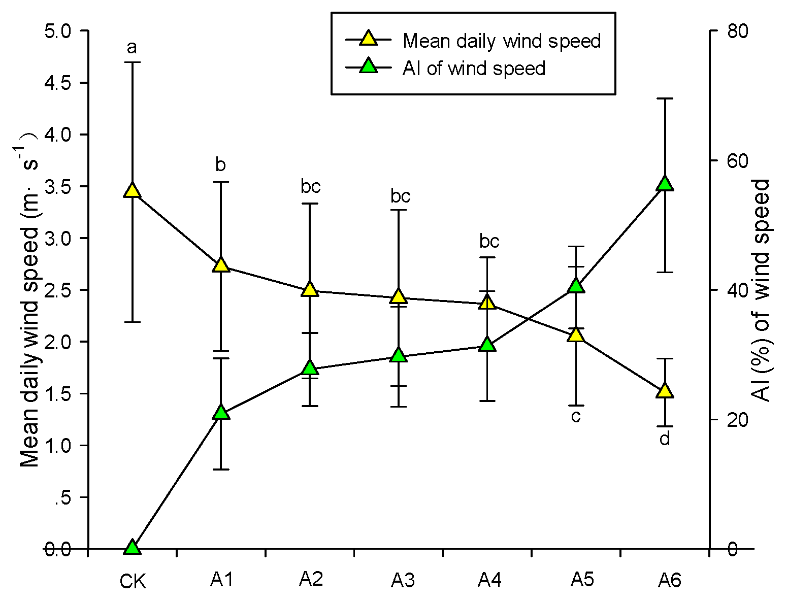
3.1.2. Age and Surface Erosion

In general, the average daily wind speed of the six differently aged forest stands was significantly lower when compared to the unforested control stand (Figure 6). There were clear trends of changes in daily mean wind speed along the time gradient of the 15–41-year-old plantations. Average daily wind speed could roughly be partitioned into two stages along the age gradient (A1–A5 and A5–A6). A similar pattern was observed when analyzing data from individual days. In the first period, daily average wind speed showed a slow decreasing trend with increasing stand age, which became more distinct in the following period. At the same time, the AI of wind speed increased with stand age, as shown in Figure 6, with an approximately three-fold increase in AI from A1 to A6.
Figure 7 shows that the average daily sand transport rates of the forested stands were significantly lower than that of the control site, irrespective of the stand age. However, with increasing stand age, the average daily sediment transport rate showed a gradual decreasing trend (Figure 8a). Similar patterns were observed for individual days (Figure 8b). On average, the daily sediment transport rate of these six forest stands was 0.43 g·m−2, while the average daily sediment transport in the control site was 3.10 g·m−2. Within the experimental period of 25 days, the declining index (DI) of wind erosion was highest in A6, followed by A5, A4, A3, A2, and A1. Based on the increasing DI (from 70.56% to 98.04%) with increasing stand age, it can be inferred that the average growth rate of DI is about 1.06% at a poplar stand age between 15 and 41 years. According to this trend, the DI will be close to 100% at a stand age of 40 years.

3.2. Effects of Stand Density and Age on Soil Amelioration

3.2.1. Density and Soil Amelioration

Figure 9, Figure 10, Figure 11, Figure 12 and Figure 13 show the soil physical and chemical properties of poplar stands with different densities and ages. The coarse sand content (0.2–2 mm) of the control site was higher than that in the forest stands, while the contents of fine sand (0.02–0.2 mm), as well as silt and clay (<0.02 mm), was significantly lower (Figure 9a), suggesting that the forested sites had a smaller particle size compared to the unforested control site. This significant structural difference indicates that poplar trees may have effects on soil development in sandy areas. With the increase in tree density, the content of soil coarse sand firstly decreased and then increased; however, the contents of soil silt and clay showed the opposite trend. Soil surface hardness is a parameter related to soil surface texture and compactness, as well as an indicator reflecting the stability of sandy land [11]. As shown in Figure 10, soil hardness of the poplar stands was significantly larger than in the control site. Nevertheless, the results of the significance analysis showed that the six different poplar stands, with different ages, did not differ significantly in soil particle size. Soil bulk density was lower in the forested sites compared to the unforested control site, with a steady decline from D1 to D4 and an increase thereafter. However, the amounts of total C, total N, and available P showed a tendency to firstly increase and then decrease (Figure 12).

3.2.2. Age and Soil Amelioration

We observed clear trends in soil texture, bulk density, and soil surface hardness along the time gradient of the 0–41-year-old plantations (Figure 9b and Figure 11). Soil bulk density is an important physical parameter indicating soil nutrient storage, water transportation, and gas penetration [26]. At a depth of 0–5 cm, bulk density decreased from 1.74g·cm−3 in the CK site (age 0) to 1.40 g·cm−3 under the 41-year-old plantation site. With increasing stand age, the content of coarse sand decreased, while that of silt and clay increased. Soil surface hardness increased from an average of 0.64 kg·cm−2 at the CK site (age 0) to 5.92 kg·cm−2 under the 41-year-old poplar forest site. At selected sites, total C, total N, and available P under tree canopies were significantly higher than in the control site (Figure 13); the levels of these elements significantly changed along the age gradient. At 15, 21, 28, 32, 37, and 41 years after stand establishment, total soil C levels in the 0–5-cm layer increased, respectively, by 2.49, 3.41, 3.57, 3.86, 3.86, and 3.95 times compared to those in the control site. Soil total N levels followed the same pattern, with an 18-fold increase at a stand age of 41 years. In terms of nutrient availability, available P increased progressively with stand age, reaching a maximum of 5.84 times that of the control site.

3.3. Comprehensive Effects of Stand Age and Density on Surface Erosion

Wind erosion is a complex process governed by numerous mechanisms and factors, which makes it difficult to establish an accurate mathematical model to evaluate this process. Modeling is usually performed using a test analysis, applying large amounts of data. In this study, two factors (poplar density and poplar age) were used to build a multivariate wind erosion model. Specifically, we used the SAS 9.0 statistical analysis software to analyze the data from the field experiment and established a multi-factor wind erosion model (Figure 14).
z = 2.6324 − 0.0024x − 0.0349y + 8.8054 × 10−7x2 + 0.0001y2,
where z is the daily sand transport (g·m−2), x is the forest age (a), and y is the forest density (trees·hm−2).
Based on this model, we obtained the daily average sediment transport values for different stand density and age combinations (Table 2). Against this background, with increasing stand age, the daily sand transport shows a decreasing trend, influenced by tree density. When the poplar stand reached an age of 40 years, the daily sand transport rate tended to be negative, indicating that wind-caused soil erosion is negligible.

4. Discussion

4.1. Impacts of Poplar Stand Density and Age on Wind Velocity and Erosion

Overall, the effects of poplar trees on wind speed and sand transport were highly significant. In this aspect, we observed significant differences among the different stands as influenced by density and age. Comparing the differences in wind speed and sediment transport rate between the forested stands and the unforested control stand, we identified the variation of sand-fixation poplar with different densities and ages in wind breaking and sand fixation. To eliminate the influence of wind direction, we designated the wind direction for the NW orientation, only considering 25 days of daily average wind speed and daily sediment transport rate data.
Our research shows that the establishment of poplar shelterbelts has a significant influence on wind conditions and erosion in sandy areas. Numerous studies showed that artificially and naturally established vegetation has an important protective effect on wind and surface soil erosion [27,28,29]. One of the main findings of this study is that, in the poplar shelterbelts, the average daily wind speed and the daily sediment transport showed a tendency to firstly decrease and then increase with increasing stand density, which is consistent with previous findings [30]. When the stand density increases, the cover degree of sand-fixing poplar also reaches a certain critical value, and the effect of cover on wind speed and sand fixation is stable. At this time, the influence of stand density on wind speed and sand fixation depends on the branch structure of the lower part of the canopy. Due to the increase in the density of poplar trees, the distance of poplar branches decreases, resulting in the formation of several high-speed “streets” (narrow tube effect) between the trees; these areas will increase wind speed and, most likely, erosion rate. Similar results were found in field observations [31], wind tunnel experiments [32], and simulation studies [33]. Liu et al. [27], in a wind tunnel study, also evaluated the effects of plant density on internal airflow and found that, under the condition of decreased plant spacing, it greatly inhibited the lateral transverse flow of adjacent plants, resulting in increased pressure in front of the plants, which led to an increase inflow. The authors concluded that dense areas were poorly protected compared with sparse distribution. In our study, there were two functional relationships between the wind speed AI, the surface wind erosion DI, and the density of the sand-fixing poplar; the maximum corresponding density of AI was 1320 trees·hm−2, and the maximum corresponding density of DI was 1368 trees·hm−2. Similar results were found in another study [30], where wind erosion control was highest at a plant cover of 60%–65%. The coverage value corresponding to the optimal density value was slightly higher in our study, possibly because of the different characteristics of the tree species. Compared with poplar trees, shrubs have no distinct trunk, consisting of branches and lobes, and larger shrubs may otherwise have a better anti-wind erosion effect at the bottom. Similar results were found in previous studies [27,34], where the lower part of the dense shrubs provided better wind erosion control than the lower part of the trees. In this sense, adding some larger shrubs and herbs to the tree stands can be a valid approach to further improve the efficiency of wind erosion protection.
With increasing forest age, the average daily wind speed and the daily sediment transport in shelterbelts decrease, probably because of the high branch density, coverage, and tree height, increasing surface roughness and, therefore, leading to decreased average wind speed. In addition, the diversity and cover level of herbaceous herbs also increased, which eventually led to a downward trend in sediment transport, as also observed previously [30,35]. In these studies, with increasing vegetation cover, at certain wind speeds, wind-caused soil erosion decreased rapidly, mainly because of higher vegetation cover.
Our results lead us to infer that, at a poplar stand age of 40 years, the near-surface wind speed reduction rate is greater than 80%, and the surface coverage is greater than 70%, with a wind erosion volume close to zero. Because studies in this field are scarce, we cannot further compare our data with previous results. However, in a study by Dong et al. [36], soil erosion was less severe when the shrub cover was greater than 60% in arid and semi-arid areas, while, at cover rates of 20%–60% and 20%, erosion was moderate and severe, respectively. Our current research was only carried out during the spring strong wind erosion season, which will provide important information to regional and national decision-makers. However, in different seasons, such as summer and autumn, and other windy weather, the effect of windbreak and sand fixation of forests remains to be reported, this study will be the focus of the future research.

4.2. Impacts of Poplar Stand Density and Age on Soil Properties

Our results show that soil properties can be improved by establishing and developing sand-fixing poplar stands. Average diameter of soil particles, surface soil hardness, and bulk density were significantly smaller in the forested sites when compared to the unforested control site; these results are in agreement with the findings of previous studies [29,37].
With increasing stand density, soil bulk density firstly decreased and then increased. However, organic carbon, total N, and available phosphorus levels showed the opposite tendency, most likely because, within a certain density range, poplar promotes herbal restoration and litter decomposition through shade provision, and the contents of total C and total N increase gradually, thus improving soil porosity and other soil traits and further decreasing soil bulk density. In addition, with the increase of organic carbon, the adsorption of phosphorus by organic matter also increased; hence, when the content of soil organic matter increased, the phosphorus absorbed by organic carbon also increased, and it could improve the availability of phosphorus and reduce the fixation of phosphorus. As a result, the pore condition of soil was improved relatively, which resulted in the decrease of soil bulk density. Poplar is a species with a high water consumption [38], and the increase in poplar density increases competition for water, resulting in a poor growth of other tree species and herbal species and decreased decomposition rates. The rapid use of soil moisture and nutrients leads to poor soil properties, which eventually results in increased soil bulk density [10]. It is also possible that, when the stand density exceeds a certain critical value, due to the influence of narrow tube effect, wind speed in forest increases relatively, and soil wind erosion increases relatively, and then the fine particulate matter which is easily disturbed by wind in the soil surface is relatively reduced, which leads to the relative coarsening of soil particles [31,33].
An important finding of this study is that, with increasing poplar stand age, the contents of coarse soil particles decreased, the contents of fine particles increased, organic carbon and total N increased, and soil bulk weight and hardness decreased. We also found that, with the increase of poplar age, the content of available phosphorus in soil also increased, which may be due to the increase of soil organic C, resulting in the soil organic matter adsorption capacity of phosphorus increasing, thus improving the effectiveness of phosphorus, reducing the fixation of phosphorus. Partly, this might be because, as stand age increased, soil erosion decreased, resulting in an increased accumulation of fine particulate matter in the surface soil. In addition, the canopy provides shade, reduces soil evaporation, improves soil moisture levels, and accelerates the growth of herbs and the decomposition of litter. Finally, with increasing forest age, the development of undergrowth herbs constitutes an important part of net primary productivity, and the decomposition of these plants results in inputs of C, N, and improved organic C, stimulating microbial communities and making nutrients available. Our results are similar to those of previous studies [39,40], while other studies showed that, with increased forest age, there are improvements of soil properties. Firstly, photosynthetic carbon sequestration, leaf litter transfer, and root turnover play a prominent role in promoting soil carbon accumulation. Secondly, the level of microbial activity in sandy ecosystems is generally low; however, after the establishment of artificial vegetation, microbial nitrogen fixation and litter decomposition release N, leading to an increase in soil N content. Thirdly, vegetation restoration results in an improved microclimate and better soil conditions.

5. Conclusions

In the semi-arid region of northern China, the establishment of poplar stands plays an important role in the restoration of sandy ecosystems. We can draw several conclusions. Firstly, the establishment of poplar stands in sandy areas can significantly reduce wind speed and wind erosion, improve soil physical properties, and enhance soil fertility. Secondly, in terms of soil property improvement, the optimal stand density is 1320–1368 trees·hm−2. Lastly, the effects of such stands gradually increase with increasing stand age. At an age of 40 years, wind erosion within the stand is significantly reduced.

Author Contributions

G.J., X.Y. and Z.L. conceived and designed the experiment; Z.L. collected data; J.Z. analyzed the data and wrote the initial draft of the manuscript; G.J., X.Y. and D.W. provided conceptual and editorial advice and rewrote significant parts of the manuscript.

Funding

This research was funded by the National Key Research and Development Program of China (2016YFC0500802), the National Research Program for Key Issues in air pollution control (DQGG0208), the Beijing Municipal Education Commission (PXM2018_014207_000024), and the Beijing Collaborative innovation center for eco-environmental improvement with forestry and fruit trees (PXM2018_014207_000024).

Acknowledgments

The authors would like to thank for Lele Sun for field assistance. We thank the associate editor and anonymous reviewers for their helpful and valuable comments that improved this manuscript.

Conflicts of Interest

The authors declare no competing interests.

References

  1. Guo, Z.L.; Huang, N.; Dong, Z.B.; Van Pelt, R.; Zobeck, T. Wind erosion induced soil degradation in northern China: Status, measures and perspective. Sustainability 2014, 6, 8951–8966. [Google Scholar] [CrossRef]
  2. Chappell, A.; Lee, J.A.; Baddock, M.; Gill, T.E.; Herrick, J.E.; Leys, J.F.; Marticorena, B.; Petherick, L.; Schepanski, K.; Tatarko, J.; et al. A clarion call for aeolian research to engage with global land degradation and climate change. Aeolian Res. 2018, 32, A1–A3. [Google Scholar] [CrossRef]
  3. Middleton, N.J. Desert dust hazards: A global review. Aeolian Res. 2017, 24, 53–63. [Google Scholar] [CrossRef]
  4. Zhang, K.C.; An, Z.S.; Cai, D.W.; Guo, Z.C.; Xiao, J.H. Key role of desert–oasis transitional area in avoiding oasis land degradation from aeolian desertification in Dunhuang, Northwest China. Land Degrad. Dev. 2017, 28, 142–150. [Google Scholar] [CrossRef]
  5. Ouyang, Z.H.; Zheng, H.; Xiao, Y.; Polasky, S.P.; Liu, J.G.; Xu, W.H.; Wang, Q.; Zhang, L.; Xia, Y. Improvements in ecosystem services from investments in natural capital. Science 2016, 352, 1455–1459. [Google Scholar] [CrossRef]
  6. Li, F.R.; Zhao, A.F.; Zhou, H.Y.; Zhang, T.H.; Zhao, X. Effects of simulated grazing on growth and persistence of Artemisia frigida in a semiarid sandy rangeland. Grass Forage Sci. 2002, 57, 239–246. [Google Scholar] [CrossRef]
  7. Wang, X.M.; Zhang, C.X.; Hasi, E.; Dong, Z.B. Has the Three Norths Forest Shelterbelt Program solved the desertification and dust storm problems in arid and semiarid China? J. Arid Environ. 2010, 74, 13–22. [Google Scholar] [CrossRef]
  8. Wu, Z.; Wu, J.; Liu, J.; He, B.; Lei, T.; Wang, Q. Increasing terrestrial vegetation activity of ecological restoration program in the Beijing–Tianjin sand source region of China. Ecol. Eng. 2013, 52, 37–50. [Google Scholar] [CrossRef]
  9. Richardson, J.; Cooke, J.E.K.; Isebrands, J.G.; Thomas, B.R.; Van Rees, K.C.J. Poplar research in Canada—a historical perspective with a view to the future. Botany 2007, 85, 1136–1146. [Google Scholar]
  10. Chendev, Y.G.; Sauer, T.J.; Ramirez, G.H.; Burras, C.L. History of east European chernozem soil degradation; protection and restoration by tree windbreaks in the Russian steppe. Sustainability 2015, 7, 705–724. [Google Scholar] [CrossRef]
  11. Li, W.; Wang, F.; Bell, S. Simulating the sheltering effects of windbreaks in urban outdoor open space. J. Wind Eng. Ind. Aerod. 2007, 95, 533–549. [Google Scholar] [CrossRef]
  12. Zhan, K.J.; Liu, S.Z.; Yang, Z.H.; Fang, E.T.; Zhou, L.P.; Huang, N. Effects of sand-fixing and windbreak forests on wind flow: A synthesis of results from field experiments and numerical simulations. J. Arid. Land 2017, 9, 1–12. [Google Scholar] [CrossRef]
  13. Zhu, J.J. A review of the present situation and future prospect of science of protective forest. Chin. J. Plant Ecol. 2013, 37, 872–888. [Google Scholar] [CrossRef]
  14. Cheng, G.D.; Li, X.; Zhao, W.Z.; Xu, Z.M.; Feng, Q.; Xiao, S.C.; Xiao, H.L. Integrated study of the water–ecosystem–economy in the Heihe River Basin. Natl. Sculpt. Rev. 2014, 1, 413–428. [Google Scholar] [CrossRef] [Green Version]
  15. Wang, H.J.; Zhou, H. A simulation study on the eco-environmental effects of 3N Shelterbelt in North China. Glob. Planet Chang. 2003, 37, 231–246. [Google Scholar]
  16. Tun, T.N.; Guo, J.; Fang, S.Z.; Tian, Y. Planting spacing affects canopy structure, biomass production and stem roundness in poplar plantations. Scand. J. For. Res. 2018, 33, 464–474. [Google Scholar] [CrossRef]
  17. Amichev, B.Y.; Bentham, M.J.; Cerkowniak, D.; Kort, J.; Kulshreshtha, S.; Laroque, C.P.; Piwowar, J.M.; Van Rees, K.J. Mapping and quantification of planted tree and shrub shelterbelts in Saskatchewan, Canada. Agrofor. Syst. 2015, 89, 49–65. [Google Scholar] [CrossRef]
  18. Li, F.R.; Liu, J.L.; Sun, T.S.; Ma, L.F.; Liu, L.L.; Yang, K. Impact of established shrub shelterbelts around oases on the diversity of ground beetles in arid ecosystems of Northwestern China. Insect Conserv. Diver. 2016, 9, 135–148. [Google Scholar] [CrossRef]
  19. Leenders, J.K.; Sterk, G.; van Boxel, J.H. Wind erosion reduction by scattered woody vegetation in farmers’ fields in northern Burkina Faso. Land Degrad. Dev. 2016, 27, 1863–1872. [Google Scholar] [CrossRef]
  20. Borrelli, P.; Lugato, E.; Montanarella, L.; Panagos, P. A new assessment of soil loss due to wind erosion in European agricultural soils using a quantitative spatially distributed modelling approach. Land Degrad. Dev. 2017, 28, 335–344. [Google Scholar] [CrossRef]
  21. Breshears, D.D.; Whicker, J.J.; Zou, C.B.; Field, J.P.; Allen, C.D. A conceptual framework for dryland aeolian sediment transport along the grassland–forest continuum: Effects of woody plant canopy cover and disturbnce. Geomorphology 2009, 105, 28–38. [Google Scholar] [CrossRef]
  22. Bao, Y.H.; Li, H.Y.; Yang, J.H. Effects of Shelterbelts on Wind Erosion Control in the Desertified Cropland of North-Western Shandong Province, China. In Proceedings of the 2011 5th International Conference on Bioinformatics and Biomedical Engineering, Wuhan, China, 10–12 May 2011. [Google Scholar]
  23. Leenders, J.K.; Visser, S.M.; Stroosnijder, L. Farmers’ perceptions of the role of scattered vegetation in wind erosion control on arable land in Burkina Faso. Land Degrad. Dev. 2005, 16, 327–337. [Google Scholar] [CrossRef]
  24. Mao, R.; Zeng, D.H.; Hu, Y.L.; Li, L.J.; Yang, D. Soil organic carbon and nitrogen stocks in an age-sequence of poplar stands planted on marginal agricultural land in Northeast China. Plant Soil 2010, 332, 77–287. [Google Scholar] [CrossRef]
  25. Wu, Y.; Wang, W. Poplar forests in NE China and possible influences on soil properties: Ecological importance and sustainable development. In Poplars & Willows, Cultivation, Applications & Environmental Benefits; Desmond, M., Ed.; Nova Publishers: Hauppauge, NY, USA, 2016; pp. 1–28. [Google Scholar]
  26. Wang, W.J.; Liu, W.; Sun, W.; Zu, Y.G.; Cui, S. Influences of forest floor cleaning on the soil respiration and soil physical property of a larch plantation in Northeast China. stxben 2008, 28, 4750–4756. [Google Scholar]
  27. Liu, C.C.; Zheng, Z.Q.; Cheng, H.; Zou, X.Y. Airflow around single and multiple plants. Agric. For. Meteorol. 2018, 252, 27–38. [Google Scholar] [CrossRef]
  28. Yan, Y.C.; Wang, X.; Guo, Z.J.; Chen, J.Q.; Xin, X.P.; Xu, D.W.; Yan, R.R.; Chen, B.R.; Xu, L.J. Influence of wind erosion on dry aggregate size distribution and nutrients in three steppe soils in northern China. Catena 2018, 170, 159–168. [Google Scholar] [CrossRef]
  29. Li, G.S.; Qu, J.J.; Han, Q.J.; Fang, H.Y.; Wang, W.F. Responses of three typical plants to wind erosion in the shrub belts atop Mogao Grottoes, China. Ecol. Eng. 2013, 57, 293–296. [Google Scholar] [CrossRef]
  30. Lv, P.; Dong, Z.B. Study of the windbreak effect of shrubs as a function of shrub cover and height. Environm. Earth Sci. 2012, 66, 1791–1795. [Google Scholar] [CrossRef]
  31. Okin, G.S.; Gillette, D.A. Distribution of vegetation in wind-dominated landscapes: Implications for wind erosion modeling and landscape processes. J. Geophys. Res.-Atmos. 2001, 106, 9673–9683. [Google Scholar] [CrossRef] [Green Version]
  32. Burri, K.; Gromke, C.; Lehning, M.; Graf, F. Aeolian sediment transport over vegetation canopies: A wind tunnel study with live plants. Aeolian Res. 2011, 3, 205–213. [Google Scholar] [CrossRef]
  33. Dupont, S.; Bergametti, G.; Simoëns, S. Modeling aeolian erosion in presence of vegetation. J. Geophys. Res.-Earth 2014, 119, 168–187. [Google Scholar] [CrossRef] [Green Version]
  34. Cornelis, W.M.; Gabriels, D. Optimal windbreak design for wind-erosion control. J. Arid Environ. 2005, 61, 315–332. [Google Scholar] [CrossRef]
  35. Cui, Q.; Feng, Z.; Pfiz, M.; Veste, M.; Kuppers, M.; He, K.N.; Gao, J.R. Trade-off between shrub plantation and wind-breaking in the arid sandy lands of Ningxia, China. Pak. J. Bot. 2012, 44, 1639–1649. [Google Scholar]
  36. Dong, Z.B.; Chen, G.T.; He, X.D.; Han, Z.W.; Wang, X.M. Controlling blown sand along the highway crossing the Taklimakan Desert. J. Arid Environ. 2004, 57, 329–344. [Google Scholar] [CrossRef] [Green Version]
  37. Jeddi, K.; Chaie, M. Changes in soil properties and vegetation following livestock grazing exclusion in degraded arid environments of South Tunisia. Flora 2010, 205, 184–189. [Google Scholar] [CrossRef]
  38. Sun, S.J.; Qiu, L.F.; He, C.X.; Li, C.Y.; Zhang, J.S.; Meng, P. Drought-Affected Populus simonii Carr. Show Lower Growth and Long-Term Increases in Intrinsic Water-Use Efficiency Prior to Tree Mortality. Forests 2018, 9, 564. [Google Scholar] [CrossRef]
  39. Zuo, X.A.; Zhao, X.Y.; Zhao, H.L.; Zhang, T.H.; Guo, Y.R.; Li, Y.Q.; Huang, Y.X. Spatial heterogeneity of soil properties and vegetation–soil relationships following vegetation restoration of mobile dunes in Horqin Sandy Land, Northern China. Plant Soil 2009, 318, 153–167. [Google Scholar] [CrossRef]
  40. Su, Y.Z.; Li, Y.L.; Cui, J.Y.; Zhao, W.Z. Influences of continuous grazing and livestock exclusion on soil properties in a degraded sandy grassland, Inner Mongolia, Northern China. Catena 2005, 59, 267–278. [Google Scholar]
Figure 1. Location of the study area in Zhangbei County, Hebei Province, China. The green circle with black dots represents the location of the field site. CK, the control site; D1, site with a forest density of 500 trees·hm−2; D2, site with a forest density of 750 trees·hm−2; D3, site with a forest density of 1025 trees·hm−2; D4 site with a forest density of 1200 trees·hm−2; D5, site with a forest density of 1425 trees·hm−2; D6, site with a forest density of 1700 trees·hm−2. A1, site with a forest age of 15 years (A1 and D2 are the same parcel); A2, site with a forest age of 21 years; A3, site with a forest age of 28 years; A4, site with a forest age of 32 years; A5, site with a forest age of 37 years; A6, site with a forest age of 41 years.
Forests 10 00315 g001
Figure 2. Sketch map of a trap in the field site. The unit is cm.
Forests 10 00315 g002
Figure 3. Variations in mean daily wind speed at 2-m height and the attenuation index (AI) of wind speed. Means with different letters indicate significant differences at p < 0.05. Vertical bars represent ± standard deviation.
Forests 10 00315 g003
Figure 4. Variations in mean daily sand transport rate and the declining index (DI) of wind erosion. Means with different letters indicate significant differences at p < 0.05. Vertical bars represent ± standard deviation.
Forests 10 00315 g004
Figure 5. Relationships between poplar density and mean daily wind speed and daily sand transport rate: (a) relationship between mean daily wind speed at 2-m height in the six experiment sites with different densities and mean daily wind speed at 2-m height in the control site; (b) relationship between mean daily sand transport rate in the experiment sites with different densities and mean daily wind speed at 2-m height in the control site.
Forests 10 00315 g005
Figure 6. Variations in mean daily wind speed at 2-m height and the AI of wind speed. Means with different letters indicate significant differences at p < 0.05. Vertical bars represent ± standard deviation.
Forests 10 00315 g006
Figure 7. Variations in mean daily sand transport rate and the declining index (DI) of wind erosion. Means with different letters indicate significant differences at p < 0.05. Vertical bars represent ± standard deviation.
Forests 10 00315 g007
Figure 8. Relationships between poplar age and mean daily wind speed and daily sand transport rate: (a) relationship between mean daily wind speed at 2-m height in the six experiment sites with different ages and mean daily wind speed at 2-m height in the control site; (b) relationship between mean daily sand transport rate in the six experiment sites with different ages and mean daily wind speed at 2-m height in the control site.
Forests 10 00315 g008
Figure 9. Relationship between poplar density, age, and soil particulate size composition: (a) particulate size composition of soil in the six experiment sites with different densities and the control site; (b) particulate size composition of soil in the six experiment sites with different ages and the control site.
Forests 10 00315 g009
Figure 10. Relationship between poplar density and soil bulk density and soil surface hardness. Means with different letters indicate significant differences at p < 0.05. Vertical bars represent ± standard deviation.
Forests 10 00315 g010
Figure 11. Relationship between poplar age and soil bulk density and soil surface hardness. Means with different letters indicate significant differences at p < 0.05. Vertical bars represent ± standard deviation.
Forests 10 00315 g011
Figure 12. Relationship between poplar density and soil chemical indexes. Means with different letters indicate significant differences at p < 0.05. Vertical bars represent ± standard deviation.
Forests 10 00315 g012
Figure 13. Relationship between poplar age and soil chemical indexes. Means with different letters indicate significant differences at p < 0.05. Vertical bars represent ± standard deviation.
Forests 10 00315 g013
Figure 14. Relationship between poplar density, age, and daily sand transport rate in Zhangbei County, Hebei Province, China.
Forests 10 00315 g014
Table 1. Summary of the basic conditions of the forest sites and the unforested control site in Zhangbei County, Hebei Province, China.
Field SiteAge (years)Density (trees·hm−2)Mean Height (m)Mean Diameter at Breast Height (cm)Average Crown Extension (m)
A1157505.210.32.4
A2217507.612.92.8
A32875011.018.93.9
A43275011.720.83.6
A53775018.124.05.4
A64175022.027.95.5
D1155005.710.62.9
D2157505.210.32.4
D31510256.110.22.7
D41512005.610.02.5
D51514255.410.53.1
D61517005.310.52.5
CK00000
Table 2. Daily sand transport rates under the different poplar stand densities and age combinations in Zhangbei County, Hebei Province, China.
x (trees·hm−2)y (years)z (g·m−2)x (trees·hm−2)y (years)z (g·m−2)x (trees·hm−2)y (years)z (g·m−2)x (trees·hm−2)y (years)z (g·m−2)x (trees·hm−2)y (years)z (g·m−2)
400101.47 400201.16 400300.86 400400.58 400500.32
600101.17 600200.85 600300.55 600400.27 600500.01
800100.94 800200.62 800300.32 800400.04 80050−0.22
1000100.77 1000200.45 1000300.16 100040−0.12 100050−0.38
1200100.68 1200200.36 1200300.06 120040−0.22 120050−0.47
1400100.66 1400200.34 1400300.04 140040−0.24 140050−0.50
1600100.71 1600200.39 1600300.09 160040−0.19 160050−0.45
1800100.83 1800200.51 1800300.21 180040−0.07 180050−0.33

