Wildfire Risk Assessment and Zoning by Integrating Maxent and GIS in Hunan Province, China
Abstract
:1. Introduction
2. Materials and Methods
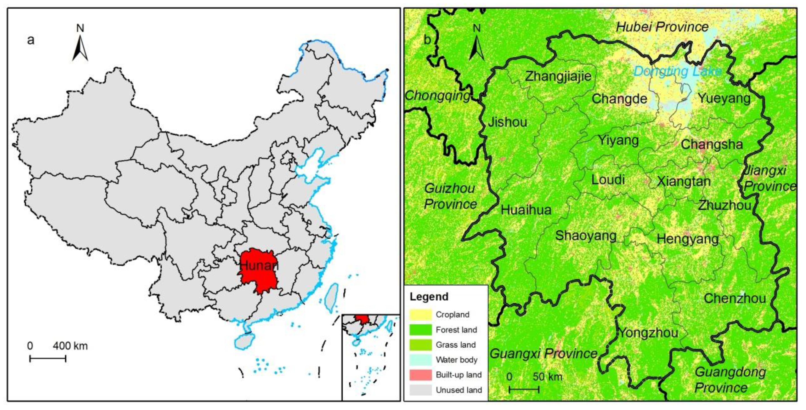
2.1. Study Area
2.2. Wildfire Disaster-Causing Mechanisms
- (1)
- Topography can affect the occurrence and development of wildfire in many ways. Geographical units with different terrain, elevation, slope, aspect, and relief, by affecting the spatial distribution of climatic factors such as moisture, light, and heat will affect the vegetation cover density, moisture accumulation, as well as the aridity and humidity of surface forest vegetation. This provides different types of combustible reserves and dry matter types that affect the nature of wildfire. Furthermore, when a wildfire occurs, variations in terrain will cause different degrees of interference and difficulties when humans attempt to control and extinguish a fire. Terrain can contribute to the spread of wildfire and delay firefighting opportunities and operations.
- (2)
- Climatic conditions vary at spatiotemporal scales and are very heterogeneous spatially, but they are the important factors contributing to the nature of a wildfire. Studies have shown that temperature, humidity, wind speed, and aridity have significant effects on wildfire [33]. An increase in temperature increases the temperature of combustible materials and reduces the heat required for combustible materials to reach the ignition point, thus greatly increasing any wildfire risk index. Similarly, precipitation is positively correlated with the water content of combustible materials. An increase in precipitation increases the relative humidity of air and reduces the dryness of combustible materials, thus significantly increasing the heat required for combustible materials to reach the ignition point and therefore reduces wildfire risk. Wind speed is the main factor that determines where a fire will burn and how rapidly a wildfire will spread. Greater wind speeds will help to cause a greater number of uncontained fires, and the fire situation in a period of high winds will become more dangerous.
- (3)
- One of the three conditions needed for a wildfire to occur is the presence of combustible material, the amount and nature of which can greatly affect the occurrence and development of fires. The other two things a fire needs are an ignition source and oxygen. Forest vegetation, as the main fuel for fires, is an important environmental factor affecting the distribution of wildfire. Differences in vegetation attributes, such as vegetation type, vegetation cover, dryness of combustible materials, and types of combustible materials present have different effects on the accumulation of combustible material, the rate of wildfire spread, and the potential release of energy [41].
- (4)
- Human activities significantly influence the occurrence of wildfire, such as by influencing surface vegetation types, changing the state of combustible materials, actively producing fire sources, and fire suppression efforts. Currently, the main factors often used to characterize the impact of human activities on wildfire are population density, arable land area, gross national product per capita, livestock load, road density, and distance from roads.
2.3. Maxent Based Fire Risk Assessment
2.4. Influence Variables and Pre-Processing
2.4.1. Wildfire Locations
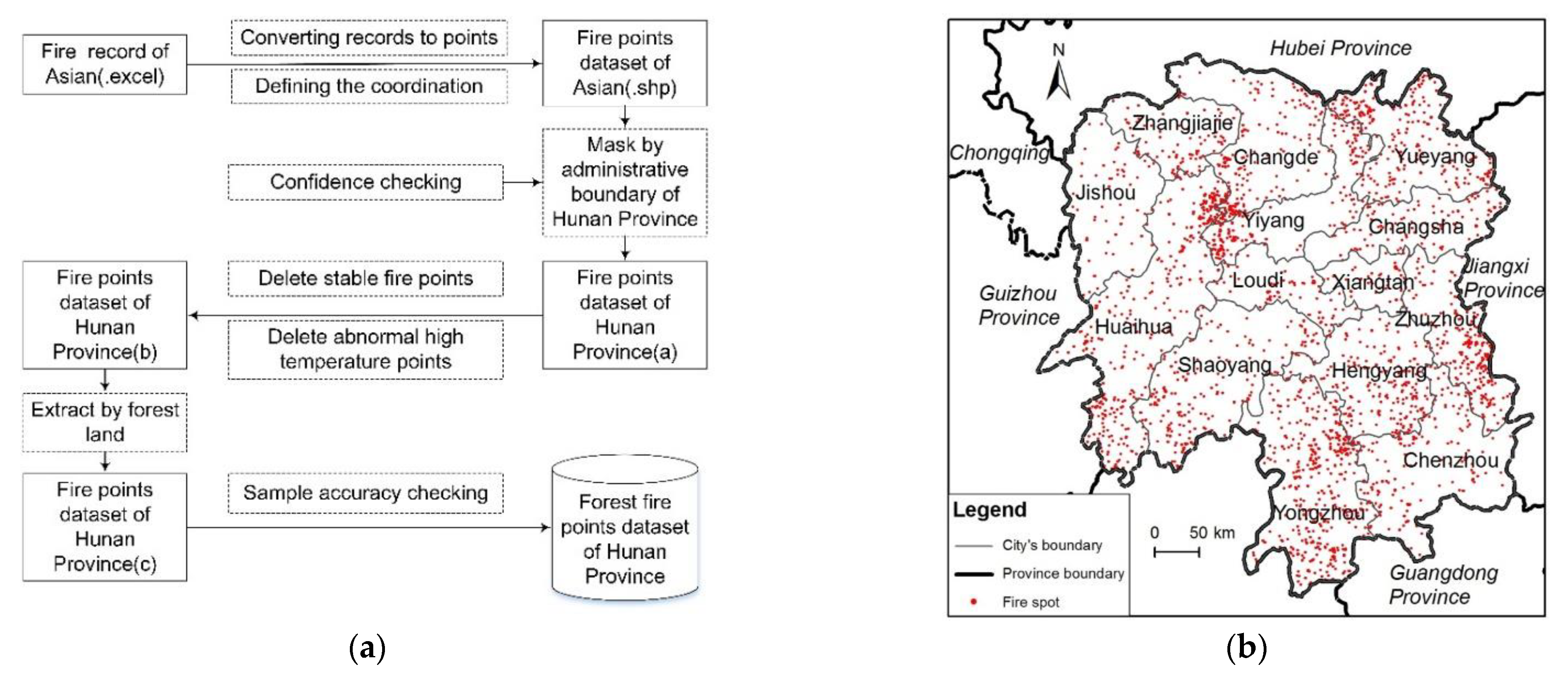
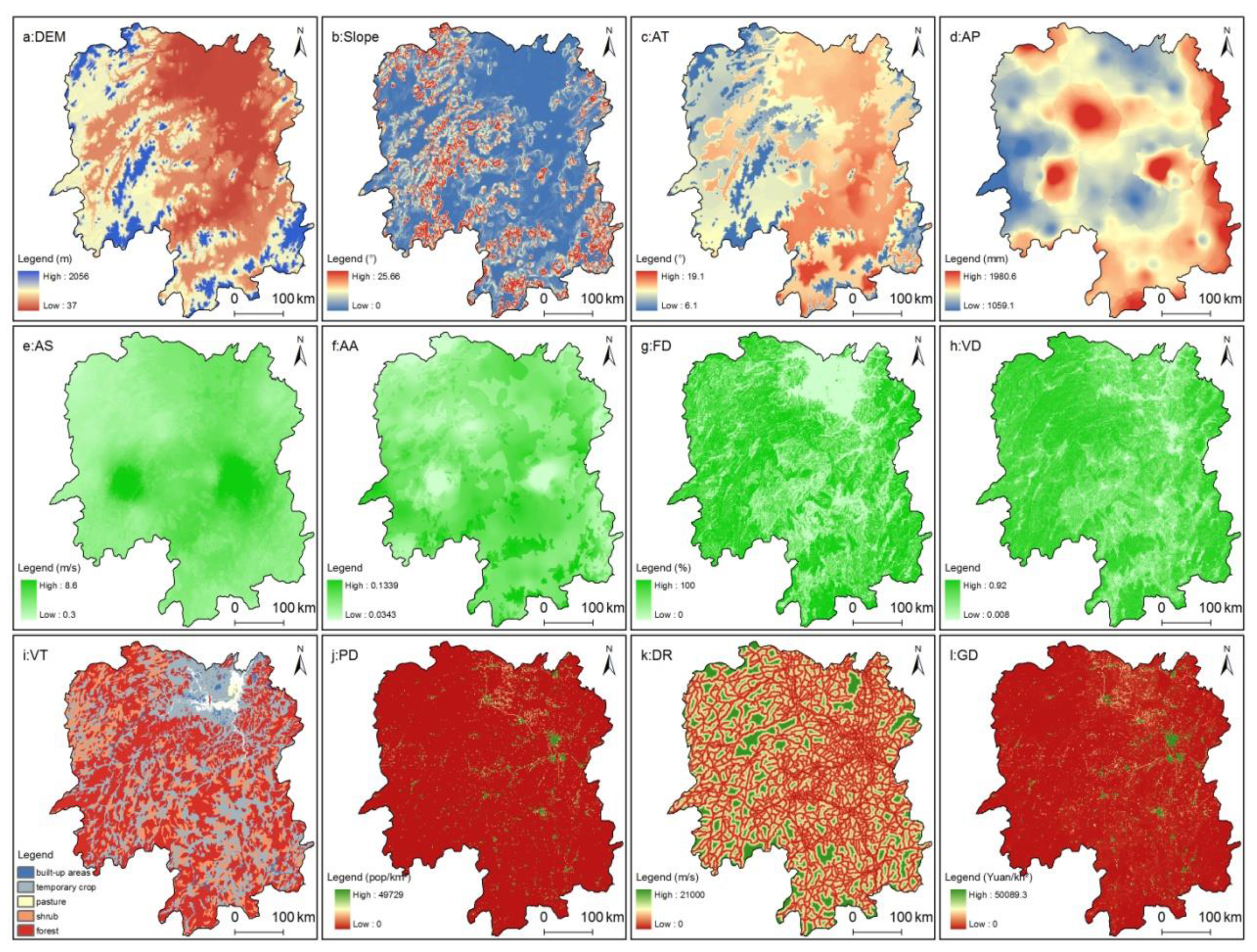
2.4.2. Environmental Variables
2.5. Running the Maxent Model
3. Results and Analysis
3.1. Influence of Environmental Factors on Fire Risk
3.2. Relationships between Environmental Factors with Wildfire
- (1)
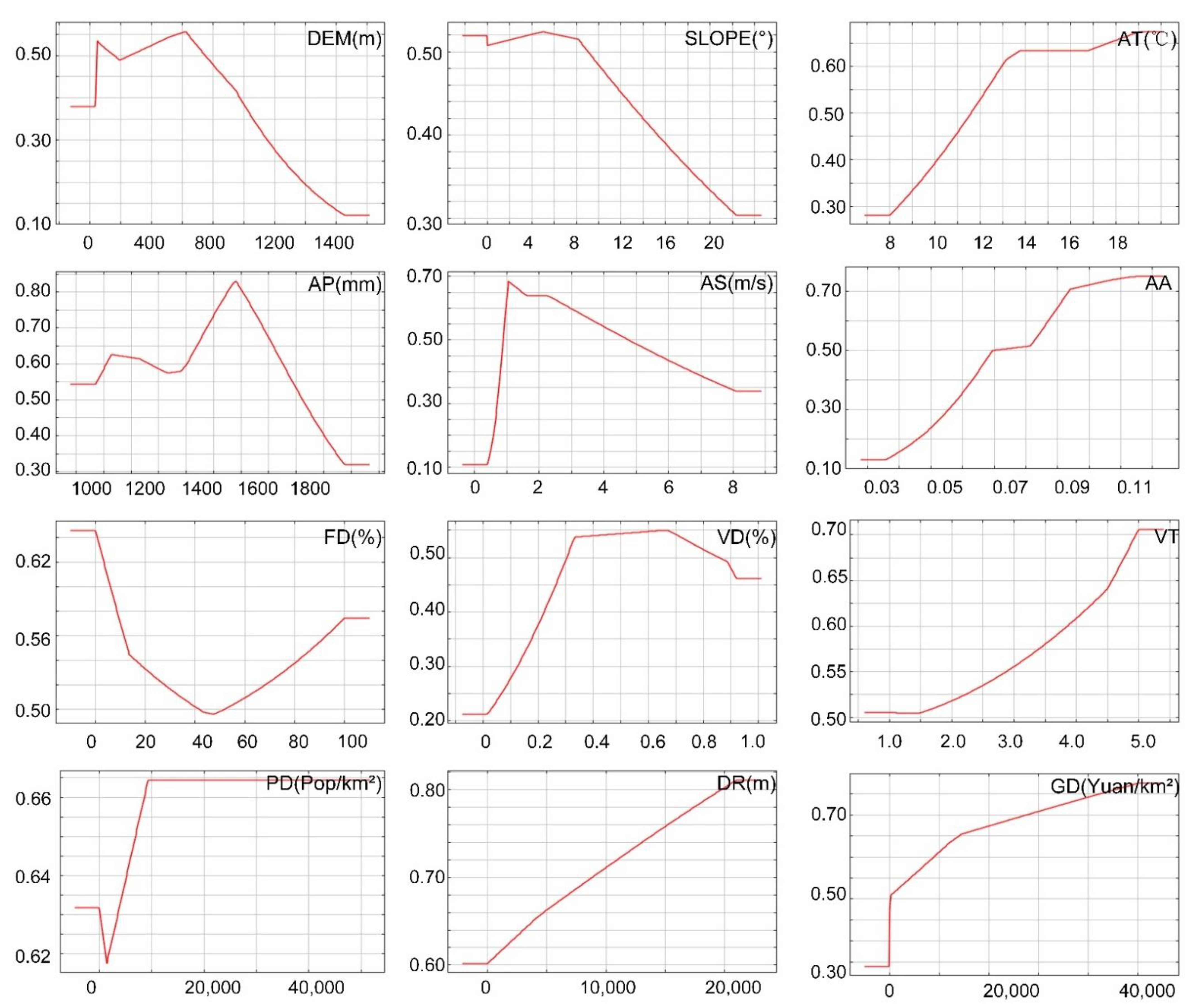
- The probability of wildfire increases and then decreases with increasing elevation. That is, wildfire is more likely to be distributed in low elevation areas, with the suitable interval being 40–780 m and 620 m being the most suitable elevation, which may be related to the fact that fewer human activities occur in high elevation areas. The probability of wildfire increases significantly as the slope increases from 0° to 9°, with a peak at about 5°, after which the probability of wildfire decreases sharply as the slope increases. Fires are more prone to occur on flat and gentle slopes, while the probability of wildfire on steep slopes is lower due to poor accessibility to humans who start fewer fires on steep slopes.
- (2)
- The average annual temperature plays a positive role in promoting wildfire; the probability of wildfire increases with increasing temperature. When the annual average temperature is higher than 11.7 °C, the probability of wildfire is greater than 0.5. When the annual average temperature is higher than 14 °C, the change in the probability of wildfire is not significant. Meanwhile, when the temperature is too low, the cumulative temperature of combustible materials is lower, so that more heat is needed to reach the point of ignition, so the probability of wildfire should be lower. As the temperature increases, the limiting factor that restricts the ignition of combustible materials may change from temperature to such factors as fire source, combustible material state, and precipitation.
- (3)
- The response of wildfire probability to aridity, land use type, GDP density, and distance from road is essentially similar to that of annual average temperature. The higher the aridity, the higher the probability of wildfire. When the land use type is dominated by forest, scrub, and other vegetation types, the accumulation of combustible materials is higher, and the probability of wildfire increases. Areas with a high GDP density will have more intense economic activity, creating a greater possibility of wildfire. The response mechanism of wildfire to distance from the nearest road conflicts with the past popular belief, i.e., the more distant the area from roads, the greater the possibility of fires; this may be related to the fact that an initial fire source is not easily detected or extinguished in areas farther from roads.
- (4)
- The suitable annual average precipitation interval for wildfire is from 1000 to 1830 mm, while an annual precipitation of 1580 mm is the most suitable peak for wildfire to occur. The probability of wildfire is less than 0.5 when the annual precipitation is higher than 1830 mm. Precipitation determines the rate of forest growth and the accumulation of stock volume. If the annual precipitation is too low, the site is not suitable for forest growth. If the annual precipitation is too high, the accumulated temperature of combustible materials will decline, causing an increase in the temperature required for ignition, thus reducing the probability of wildfire.
- (5)
- The response curves of the wildfire probability to wind speed and vegetation cover show a single-peak trend. When the wind speed is lower than 0.9 m/s or higher than 4.8 m/s, the wildfire probability is significantly lower than 0.5. The probability of wildfire peaks with a wind speed of 1.1 m/s. When the forest vegetation cover is between 32% and 85%, the probability of wildfire is significantly higher than 0.5 and peaks at 67%. Areas with vegetation cover greater than 85% are not suitable for wildfire. The response of the probability of wildfire to woodland density showed a U-shaped pattern. When woodland density is either too high or too low, this will promote the occurrence of wildfire. The probability of wildfire increases significantly when the density of woodland is below 41% or above 52%.
- (6)
- The response of the probability of wildfire to population density is generally consistent with popular beliefs, i.e., the higher the population density, the greater the chance of wildfire occurrence. Specifically, the probability of wildfire gradually decreases or increases when the population density is lower or higher than 100 people/km2, respectively. However, it remains unchanged when the population density reaches 9500 people/km2 or higher. This response pattern may be related to natural or man-made fire sources. When the population density is less than 100 people/km2, human activities disturb fewer areas. In this case, wildfires are more likely to be caused by natural conditions, such as lightning fires, the spontaneous combustion of peak, and sparks caused by rolling rocks. In contrast, with increasing population density, human activities are more widespread, intensifying disturbance, so that the possibility of human-caused fire increases dramatically, thus increasing the likelihood of wildfire.
3.3. Fire Risk Zoning
4. Discussions and Conclusions
4.1. Discussions
4.1.1. Comparison of BLR and Maxent
4.1.2. Future Research
4.2. Conclusions
- (1)
- For wildfire, the importance of environmental variables in descending order includes climatic conditions, vegetation, human activities, and topography, while the contribution of environmental variables in descending order includes climatic conditions, vegetation, topography, and human activities. The interaction between environmental factors reduces the importance of climatic conditions and human activities in the model, while in contrast, the importance of topography and vegetation variables increased.
- (2)
- The mechanisms by which environmental variables affect wildfire are complex and variable. The response curves of wildfire to the 12 selected environmental variables are not linear but are complex and nonlinear; the average annual temperature, aridity, land use type, GDP density, distance from roads, and population density have a nonlinear positive correlation with wildfire probability. In contrast, elevation, slope, precipitation, wind speed, and vegetation cover within a suitable interval have a positive promoting effect on wildfire probability. The environmental state outside the suitable interval will curb wildfire. The response of wildfire probability to forest density is U-shaped. When forest density is either too high or too low, density will promote the occurrence of wildfire.
- (3)
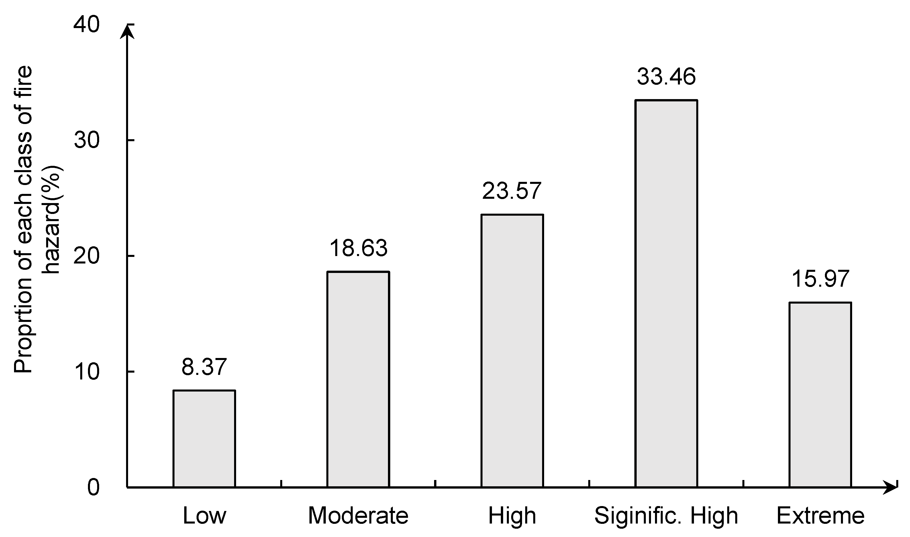
- The geographical differentiation of wildfire risk in Hunan Province is obvious. The areas at lowest to high risk accounted for 74.48% of the total area, while the areas at significantly high risk and above accounted for a relatively low 25.52%. From the spatial distribution pattern, the extremely high risk areas are mainly distributed in Nanling, and the Yangming and Dawei mountains, along with the middle reaches of Yuanjiang River. The areas of significantly high risk are concentrated in Yiyang, Yueyang, and Changzhutan areas along Dongting Lake. The high and moderate risk areas account for the largest proportion, but the spatial distribution of clustering is not obvious. The low risk areas are concentrated in the Wuyi and Xuefeng mountain ranges.
Author Contributions
Funding
Institutional Review Board Statement
Informed Consent Statement
Data Availability Statement
Conflicts of Interest
References
- Forkel, M.; Dorigo, W.; Lasslop, G.; Teubner, I.; Chuvieco, E.; Thonicke, K. A data-driven approach to identify controls on global fire activity from satellite and climate observations (SOFIA V1). Geosci. Model Dev. 2017, 10, 4443–4476. [Google Scholar] [CrossRef] [Green Version]
- Walker, X.J.; Baltzer, J.L.; Cumming, S.G.; Day, N.J.; Ebert, J.; Goetz, S.; Johnstone, J.F.; Potter, S.; Rogers, B.R.; Schuur, E.A.G.; et al. Increasing wildfires threaten historic carbon sink of boreal forest soils. Nature 2019, 572, 520–523. [Google Scholar] [CrossRef]
- Chuvieco, E.; Mouillot, F.; Werf, G.R.; San Miguel, J.; Tanase, M.; Koutsias, N.; García, M.; Yebra, M.; Padilla, M.; Gitas, I.; et al. Historical background, and current developments for mapping burned area from satellite Earth observation ScienceDirect. Remote Sens. Environ. 2019, 225, 45–64. [Google Scholar] [CrossRef]
- Gao, X.P.; Liao, S.Z. Design and implementation of forest fire probability prediction system based on Bayesian network. Comput. Eng. Appl. 2017, 53, 246–251. [Google Scholar]
- An, H.; Gan, J.; Cho, S.J. Assessing climate change impacts on wildfire risk in the United States. Forests 2015, 6, 3197–3211. [Google Scholar] [CrossRef] [Green Version]
- Chen, L.D.; Fu, B.J. Ecological significance characteristic and types of disturbance. Acta Ecol. Sin. 2000, 20, 581–586. [Google Scholar]
- Di, L.Y.; Sun, R.Y. Summarization of research on forest fire in China. J. Catastrophol. 2007, 22, 118–123. [Google Scholar]
- Yue, C.; Luo, C.F.; Shu, L.F.; Shen, Z.H. A review on wildfire studies in the context of global change. Acta Ecol. Sin. 2020, 40, 385–401. [Google Scholar]
- Andela, N.; Morton, D.C.; Giglio, L.; Paugam, R.; Chen, Y.; Hantson, S.; van der Werf, G.R.; Randerson, J.T. The global fire atlas of individual fire size, duration, speed and direction. Earth Syst. Sci. Data 2019, 11, 529–552. [Google Scholar] [CrossRef] [Green Version]
- Qayum, A.; Ahmad, F.; Arya, R.; Singh, R.K. Predictive modeling of forest fire using geospatial tools and strategic allocation of resources: eForestFire. Stoch. Environ. Res. Risk Assess. 2020, 34, 2259–2275. [Google Scholar] [CrossRef]
- Pang, Y.; Jia, W.; Qin, X.L.; Si, L.; Liang, X.J.; Lin, X.; Lin, Z.Y. Forest fire monitoring using airborne optical full spectrum remote sensing data. J. Remote Sens. 2020, 24, 1280–1292. [Google Scholar]
- Kaufman, Y.J.; Hobbs, P.V.; Kirchhoff, V.W.J.; Artaxo, P.; Remer, L.A.; Holben, B.N.; King, M.D.; Ward, D.E.; Prins, E.M.; Longo, K.M.; et al. Smoke, cloud and radiation-Brazil SCAR-B experiment. J. Geophys. Res. 1998, 103, 783–808. [Google Scholar] [CrossRef] [Green Version]
- McCarley, T.R.; Kolden, C.A.; Vaillant, N.M.; Hudak, A.T.; Smith, A.M.; Wing, B.M.; Kellogg, B.S.; Kreitler, J. Multi-temporal LiDAR and Landsat quantification of fire-induced changes to forest structure. Remote Sens. Environ. 2017, 191, 419–432. [Google Scholar] [CrossRef] [Green Version]
- Asner, G.P.; Knapp, D.E.; Kennedy-Bowdoin, T.; Jones, M.O.; Martin, R.E.; Boardman, J.W.; Field, C.B. Carnegie airborne observatory: In-flight fusion of hyperspectral imaging and waveform light detection and ranging (wLiDAR) for three-dimensional studies of ecosystems. J. Appl. Remote Sens. 2007, 1, 1–21. [Google Scholar] [CrossRef]
- Kampe, T.U.; Johnson, B.R.; Kuester, M.A.; Keller, M. The first continental-scale ecological observatory with airborne remote sensing of vegetation canopy biochemistry and structure. J. Appl. Remote Sens. 2010, 043510. [Google Scholar] [CrossRef] [Green Version]
- Cook, B.D.; Corp, L.A.; Nelson, R.F.; Middleton, E.M.; Morton, D.C.; McCorkel, J.T.; Masek, J.G.; Ranson, K.J.; Ly, V.; Montesano, P.M. NASA Goddard’s LiDAR, hyperspectral and thermal (GLiHT) airborne imager. Remote Sens. 2013, 5, 4045–4066. [Google Scholar] [CrossRef] [Green Version]
- Pang, Y.; Li, Z.Y.; Ju, H.B.; Lu, H.; Jia, W.; Si, L.; Guo, Y.; Liu, Q.; Li, S.; Liu, L.; et al. LiCHy: The CAF’s LiDAR, CCD and hyperspectral integrated airborne observation system. Remote Sens. 2016, 8, 398. [Google Scholar] [CrossRef] [Green Version]
- Randerson, J.T.; Chen, Y.; Van Der Werf, G.R.; Rogers, B.M.; Morton, D.C. Global burned area and biomass burning emissions from small fires. J. Geophys. Res. Biogeosci. 2012, 117, G04012. [Google Scholar] [CrossRef]
- Ying, L.X.; Han, J.; Du, Y.S.; Shen, Z.H. Forest fire characteristics in China: Spatial patterns and determinants with thresholds. For. Ecol. Manag. 2018, 424, 345–354. [Google Scholar] [CrossRef]
- You, W.; Lin, L.; Wu, L.; Ji, Z.; Yu, J.; Zhu, J.; Fan, Y.; He, D. Geographical information system-based forest fire risk assessment integrating national forest inventory data and analysis of its spatiotemporal variability. Ecol. Indic. 2017, 77, 176–184. [Google Scholar] [CrossRef]
- Santos Mota, P.H.; Soares da Rocha, S.J.S.; Martins de Castro, N.L.; Marcatti, G.E.; de Jesus França, L.C.; Said Schettini, B.L.; Villanova, P.H.; dos Santos, H.T.; Rosados Santos, A. Forest fire hazard zoning in Mato Grosso State, Brazil. Land Use Policy 2019, 88, 104206. [Google Scholar]
- Gao, C.; Lin, H.L.; Hu, H.Q.; Song, H. A review of models of forest fire occurrence prediction in China. Chin. J. Appl. Ecol. 2020, 31, 3227–3240. [Google Scholar]
- Deng, O.; Li, Y.Q.; Feng, Z.K.; Dongyu, Z. Model and zoning of forest fire risk in Heilongjiang province based on spatial Logistic. Trans. Chin. Soc. Agric. Eng. 2012, 28, 200–205. [Google Scholar]
- Liang, H.L.; Wang, W.H.; Guo, F.T.; Lin, F.; Lin, Y. Comparing the application of logistic and geographically weighted logistic regression models for Fujian Forest fire forecasting. Acta Ecol. Sin. 2017, 37, 4128–4141. [Google Scholar]
- Su, Z.W.; Zeng, A.C.; Cai, Q.J.; Hu, H.Q. Study on prediction model and driving factors of forest fire in Da Hinggan Mountains using Gompit regression method. J. For. Eng. 2019, 4, 135–142. [Google Scholar]
- Yang, J.B.; Ma, X.X. On the basis of artificial neural network to forecast the forest fire in Guangdong Province. Sci. Silvae Sin. 2005, 41, 127–132. [Google Scholar]
- Breiman, L. Random forests. Mach. Learn. 2001, 45, 5–32. [Google Scholar] [CrossRef] [Green Version]
- Pan, D.; Yu, P.Y.; Wu, Q. Application of random forest algorithm on the forest fire prediction based on meteorological factors in the Hilly area, central Henan Province. J. Northwest For. Univ. 2018, 33, 169–177. [Google Scholar]
- Liu, S.J.; Yang, J. Modeling spatial patterns of forest fire in Heilongjiang Province using Generalized Linear Model and Maximum Entropy Model. Chin. J. Ecol. 2013, 32, 1620–1628. [Google Scholar]
- Chen, W.; Zhou, Y.; Zhou, E.; Xiang, Z.; Zhou, W.; Lu, J. Wildfire risk assessment of transmission-line corridors based on naïve bayes network and remote sensing data. Sensors 2021, 21, 634. [Google Scholar] [CrossRef]
- Amiro, B.D.; Logan, K.A.; Wotton, B.M.; Flannigan, M.D.; Todd, J.B.; Stocks, B.J.; Martell, D.L. Fire weather index system components for large fires in the Canadian boreal forest. Int. J. Wildland Fire 2004, 13, 391–400. [Google Scholar] [CrossRef]
- Considine, D.M.; Considine, G.D. National fire danger rating system. In Van Nostrand’s Scientific Encyclopedia; American Cancer Society: Atlanta, GA, USA, 2006. [Google Scholar]
- Wu, Z.; He, H.S.; Yang, J.; Liang, Y. Defining fire environment zones in the boreal forests of northeastern China. Sci. Total. Environ. 2015, 518, 106–116. [Google Scholar] [CrossRef]
- Zhang, Y.; Liu, X.; Chen, G.; Hu, G. Simulation of urban expansion based on cellular automata and maximum entropy model. Sci. China Earth Sci. 2020, 63, 701–712. [Google Scholar] [CrossRef]
- Adab, H.; Atabati, A.; Oliveira, S.; Gheshlagh, A.M. Assessing fire hazard potential and its main drivers in Mazandaran province, Iran: A data-driven approach. Environ. Monit. Assess. 2018, 190, 670. [Google Scholar] [CrossRef] [PubMed]
- Martín, Y.; Zúñiga-Antón, M.; Mimbrero, M.R. Modelling temporal variation of fire-occurrence towards the dynamic prediction of human wildfire ignition danger in northeast Spain. Geomat. Nat. Hazards Risk 2019, 10, 385–411. [Google Scholar] [CrossRef]
- Chen, F.; Du, Y.; Niu, S.; Zhao, J. Modeling Forest lightning fire occurrence in the daxinganling mountains of Northeastern China with MAXENT. Forests 2015, 6, 1422–1438. [Google Scholar] [CrossRef] [Green Version]
- Wotton, B.M.; Nock, C.A.; Flannigan, M.D. Forest fire occurrence and climate change in Canada. Int. J. Wildland Fire 2010, 19, 253–271. [Google Scholar] [CrossRef]
- Oliveira, S.; Oehler, F.; San-Miguel-Ayanz, J.; Camia, A.; Pereira, J.M. Modeling spatial patterns of fire occurrence in Mediterranean Europe using Multiple Regression and Random Forest. For. Ecol. Manag. 2012, 275, 117–129. [Google Scholar] [CrossRef]
- Fu, J.J.; Wu, Z.W.; Yan, S.J.; Zhang, Y.; Gu, X.; Du, L. Effects of climate, vegetation, and topography on spatial patterns of burn severity in the Great Xing‘an Mountains. Acta Ecol. Sin. 2020, 40, 1672–1682. [Google Scholar]
- Liu, Z.H.; Yang, J.; He, H.S.; Chang, Y. Spatial point analysis of fire occurrence and its influence factor in Huzhong forest area of the Great Xing‘an Mountains in Heilongjiang Province, China. Acta Ecol. Sin. 2011, 31, 1669–1677. [Google Scholar]
- Yi, Y.J.; Cheng, X.; Yang, Z.F.; Zhang, S.H. MaxEnt modeling for predicting the potential distribution of endangered medicinal plant (H. riparia Lour) in Yunnan, China. Ecol. Eng. 2016, 92, 260–269. [Google Scholar] [CrossRef]
- McCune, B.; Grace, J. Analysis of Ecological Communities; MJM Software Design: Glenden Beach, OR, USA, 2002. [Google Scholar]
- He, Y.; Yang, J.; Ma, Y.; Liu, J.B.; Chen, P.; Li, X.P.; Yang, Y.F. A method for fire detection using Landsat 8 data. J. Infrared Millim. Waves 2016, 35, 600–608. [Google Scholar]
- Kim, S.J.; Lim, C.-H.; Kim, G.S.; Lee, J.; Geiger, T.; Rahmati, O.; Son, Y.; Lee, W.-K. Multi-Temporal Analysis of Forest Fire Probability Using Socio-Economic and Environmental Variables. Remote Sens. 2019, 11, 86. [Google Scholar] [CrossRef] [Green Version]
- Müller, M.M.; Vilà-Vilardell, L.; Vacik, H. Towards an integrated forest fire danger assessment system for the European Alps. Ecol. Inform. 2020, 60, 101151. [Google Scholar] [CrossRef]
- Jayasinghe, S.L.; Kumar, L. Modeling the climate suitability of tea [Camellia sinensis (L.) O. Kuntze] in Sri Lanka in response to current and future climate change scenarios. Agric. For. Meteorol. 2019, 272, 102–117. [Google Scholar] [CrossRef]
- Bar, M.A.; Syphard, A.D.; Stewart, S.I.; Volker, C. Radeloff Wildfire ignition-distribution modelling: A comparative study in the Huron-Manistee National Forest, Michigan, USA. Int. J. Wildland Fire 2013, 22, 174–183. [Google Scholar]


| Type | Factors | Abbreviation | Data Properties | Data Sources | |||
|---|---|---|---|---|---|---|---|
| Min | Max | Mean | Std Dev | ||||
| Terrain | Elevation (m) | DEM | 37 | 2056 | 347 | 275.68 | Resource and environment science and data center. http://www.resdc.cn/ (accessed on 22 May 2021) |
| Terrain slope (°) | Slope | 0 | 25.66 | 1.87 | 2.72 | ||
| Climatic variables | Average air temperature (°C) | AT | 6.9 | 19.1 | 15.88 | 1.45 | National earth system science data center. http://www.geodata.cn/(accessed on 22 May 2021) |
| Annual precipitation (mm) | AP | 1063 | 1979 | 1373 | 91.23 | ||
| Annual wind speed (m/s) | AS | 0.3 | 8.6 | 1.98 | 0.84 | ||
| Average aridity | AA | 0.03 | 0.13 | 0.08 | 0.01 | ||
| Vegetation | Forest land density (%) | FD | 0 | 100 | 62.56 | 22.07 | Resource and environment science and data center. http://www.resdc.cn/(accessed on 22 May 2021) |
| Vegetation cover density (%) | VD | 0.01 | 0.92 | 0.8 | 0.11 | ||
| Land cover type | VT | built-up areas/others:1, temporary crop:2, pasture:3, shrub:4, forest:5 | |||||
| Human activity | Population density (persons/km2) | PD | 0 | 49,729 | 306 | 1854 | Resource and environment science and data center. http://www.resdc.cn/, 2015 (accessed on 22 May 2021) |
| Distance from roads (km) | DR | 0 | 21 | 2.31 | 2277 | Google map, POI, 2019 | |
| Gross domestic product density (RMB/km2) | GD | 0 | 50,089 | 599 | 2896 | Resource and environment science and data center. http://www.resdc.cn/, 2015 (accessed on 22 May 2021) | |
| Types | Factors | Permutation Importance (%) | Contribution (%) |
|---|---|---|---|
| Terrain | DEM | 6.24 | 10.43 |
| Slope | 1.62 | 1.76 | |
| Climatic variables | AT | 16.98 | 10.57 |
| AP | 26.87 | 17.58 | |
| AS | 5.33 | 12.21 | |
| AA | 5.46 | 2.67 | |
| Vegetation | FD | 7.96 | 20.81 |
| VD | 9.37 | 6.62 | |
| VT | 8.07 | 7.26 | |
| Human activity | PD | 2.33 | 2.07 |
| DR | 4.31 | 2.17 | |
| GD | 5.47 | 5.85 |
| Variable | Model Parameters | SE | Wald | Sig. | Exp(B) |
|---|---|---|---|---|---|
| DEM | −0.770 | 0.325 | 5.636 | 0.018 | 0.463 |
| SLOPE | −0.239 | 0.207 | 2.332 | 0.248 | 0.787 |
| AT | 0.673 | 0.307 | 4.797 | 0.029 | 1.961 |
| AP | 3.247 | 0.296 | 120.543 | 0.000 | 25.715 |
| AS | −1.101 | 0.273 | 16.285 | 0.000 | 0.333 |
| AA | 2.741 | 0.323 | 71.823 | 0.000 | 15.508 |
| FD | −0.196 | 0.094 | 4.352 | 0.037 | 0.822 |
| VD | −0.323 | 0.259 | 2.562 | 0.211 | 0.724 |
| VT | 0.332 | 0.072 | 21.042 | 0.000 | 1.393 |
| PD | −1.330 | 0.852 | 2.438 | 0.118 | 0.265 |
| DR | 1.091 | 0.214 | 26.097 | 0.000 | 2.978 |
| GD | 1.255 | 0.503 | 6.217 | 0.013 | 3.507 |
| Constant | −3.932 | 0.400 | 96.858 | 0.000 | 0.020 |
Publisher’s Note: MDPI stays neutral with regard to jurisdictional claims in published maps and institutional affiliations. |
© 2021 by the authors. Licensee MDPI, Basel, Switzerland. This article is an open access article distributed under the terms and conditions of the Creative Commons Attribution (CC BY) license (https://creativecommons.org/licenses/by/4.0/).
Share and Cite
Yang, X.; Jin, X.; Zhou, Y. Wildfire Risk Assessment and Zoning by Integrating Maxent and GIS in Hunan Province, China. Forests 2021, 12, 1299. https://doi.org/10.3390/f12101299
Yang X, Jin X, Zhou Y. Wildfire Risk Assessment and Zoning by Integrating Maxent and GIS in Hunan Province, China. Forests. 2021; 12(10):1299. https://doi.org/10.3390/f12101299
Chicago/Turabian StyleYang, Xuhong, Xiaobin Jin, and Yinkang Zhou. 2021. "Wildfire Risk Assessment and Zoning by Integrating Maxent and GIS in Hunan Province, China" Forests 12, no. 10: 1299. https://doi.org/10.3390/f12101299
APA StyleYang, X., Jin, X., & Zhou, Y. (2021). Wildfire Risk Assessment and Zoning by Integrating Maxent and GIS in Hunan Province, China. Forests, 12(10), 1299. https://doi.org/10.3390/f12101299


