Article

The Harvest Operability Index (HOI): A Decision Support Tool for Mechanized Timber Harvesting in Mountainous Terrain

Department of Forestry and Environmental Conservation, College of Agriculture, Forestry and Life Sciences, Clemson University, 261 Lehotsky Hall, Box 340317, Clemson, SC 29634, USA
*
Author to whom correspondence should be addressed.
Forests 2021, 12(10), 1307; https://doi.org/10.3390/f12101307
Submission received: 20 August 2021 / Revised: 19 September 2021 / Accepted: 22 September 2021 / Published: 25 September 2021

Abstract

:
Forest operations have become increasingly reliant on mechanized harvesting equipment due to their increased production capacities in competitive markets. However, operating heavy machinery in mountainous terrain poses numerous operational and accessibility challenges from steep slopes, erosion risk, and poor road access. Geographic Information Systems (GIS) have effectively been used in various studies to identify areas in mountainous landscapes that pose no or reduced constraints for harvesting equipment operation. This study introduces the Harvest Operability Index (HOI), which rates a landscape for wheel-based equipment suitability (i.e., operability) and assesses its application in 13,118 ha of the Jocassee Gorges Natural Resource Area, situated on the Southern Blue Ridge Escarpment in Northwestern South Carolina, USA. The HOI incorporated slope, distance from roads, cost distance from major highways, primary Streamside Management Zones (SMZ), stand age, and soil suitability ratings for harvesting equipment operation. Upon reclassification to a 5-tier suitability scale, the HOI revealed 60% (7824 ha) of the case study area was in a Slope Exclusion Zone, or land area inoperable for wheel-based equipment due to steep slopes. Values of Very Poor and Poor Operability occupied less than 1% (213 ha) of land area whereas Moderate Operability values were 9% of the land area (1257 ha). Values of Good Operability occupied 18% (2442 ha) of the study area and values of Very Good Operability occupied 10% (1381 ha). These results reflected the challenges of mechanized harvesting in the study area due to a preponderance of steep slopes and poorly suited soil. Our model delineated areas of high equipment operability in two locations in the study area, despite a lack of recent logging activity around them. Results of the HOI analysis offer an accessible way for forest managers to better prioritize logging operations in areas that are highly operable and therefore more likely to possess lower overall harvesting costs, for wheel-based harvesting systems. The HOI can also be used as an asset for other forest management priorities, such as identifying highly operable areas that can use timber harvesting for fuel reduction and ecological restoration in fire-dependent forests. This model can be applied to various other regions where mountainous terrain poses a limitation to wheel-based harvesting equipment operation- and where wheel-based equipment is essential to advance the pace and scale of harvesting for ecological restoration.

1. Introduction

In timber harvesting operations, there has been a growing reliance on mechanized harvesting equipment (e.g., harvesters, feller-bunchers, forwarders, and grapple skidders) due to their added benefit of increasing harvest production capacity in competitive markets [1,2,3]. Likewise, the use of such equipment is often essential for the large-scale restoration of degraded forest landscapes [4,5]. However, steep and uneven mountainous terrain creates numerous limitations and accessibility challenges for mechanized harvesting equipment and logging operations. Studies have demonstrated that slopes beyond 30% pose safety and environmental limits for wheel-based equipment [6,7,8,9]. Additionally, steep slopes exhibit harvesting productivity challenges as slopes exceeding 49% can reduce the productivity of wheeled skidders by as much as 45% [10], and travel time of wheeled skidders has been shown to increase linearly with cross slopes that exceed 4% [11]. Skidding of timber is possible on slopes exceeding 40%, however in such conditions and in downhill skidding the blockage of the wheels which could lead to a vehicle slippage is probable [12]. Also, if the load pushes the vehicle downhill, due to the constant thrust of the timber at the back end of a skidder, in due time fatigue of the material and early damage to the vehicle is to be expected. This early damage is compounded by work safety concerns and the negative influence on the psycho-physical state of the driver in such driving conditions [12]. Although tracked equipment and cable yarding systems can overcome steep slope challenges and work beyond 30% slope grades, these systems are more expensive than wheel-based equipment [7,13]. Some authors also state that technically with winch-assisted machinery, an operation is possible on slopes of up to 70% or even more, but from an ecological point of view this should be critically scrutinized since the original intention of this technology was to decrease soil damage caused by driving [14]. Although winch-assisted machinery nowadays is often used in steep terrain, authors conclude that further studies on winch-assisted machinery under real working conditions should be made to determine the possible reduction of slippage and soil damage in order to assess the ecological impacts of such technologies [14].
Heavy harvesting equipment can also cause soil compaction and rutting, which in turn, can increase sedimentation into streams through runoff and erosion [15,16,17]—the risk of which increases on steep slopes [18]. While the degree of soil compaction varies based on harvesting equipment and soil properties [19], research has demonstrated one pass of loaded harvesting equipment can increase soil compaction by 50%- with essentially all compactions being confined to skid trails [17,20]. Due to the long recovery time needed for subsoils to regain macroporosity [16,17,18,21], erosion of soil and stream sedimentation could be a continual concern even after one harvesting event. As a result, Best Management Practice (BMP) protocols have been established in the United States to preserve and protect water resources and prevent soil erosion and BMP compliance has steadily risen with loggers over time [2]. However, BMP guidelines are more rigorous with mountainous terrains, such as in the Appalachians and can increase costs for loggers to properly implement BMP measures [22,23,24].
The density of roads and the overall accessibility of harvesting sites are other important aspects for timber harvesting in mountainous terrain [25]. Skidding distances have been shown to be an important factor in machine productivity [26], and studies have demonstrated that skidding distances beyond 500 m result in pronounced losses of productivity [27,28,29]. Additionally, an optimal network of roads and skid trails can reduce the impacts of logging by limiting soil stress and stand damage [30]. With all these noted factors taken together, effective forest planning can be a valuable tool for mechanized timber harvesting in the mountains to reduce operational constraints and limit logging impact.
Geographic Information System (GIS) analyses have demonstrated many positive applications for timber harvest planning due to their ability to provide decision support systems (DSS) in large mountainous landscape contexts dominated by challenging terrain. Studies have used GIS to assess constraints, such as slope, skidding distances from roads, and waterbody presence to identify optimally suited harvesting equipment [7,8,9,30,31,32,33]. Other studies have used GIS analyses to identify suitable areas for sustainable road construction [33] and reduce soil compaction from forwarder activity [34]. GIS has also been used to determine forest road management priorities (e.g., maintenance, construction, improvements, and retiring of roads) based on maintenance costs and watershed risks [35].
Based on the demonstrated studies and capabilities of GIS for forest planning in mountainous areas, there are multiple ways to implement GIS as a DSS for mechanized harvesting in mountainous terrain. This study introduces the “Harvest Operability Index” (HOI), a GIS suitability model for mechanized timber harvesting using wheeled equipment in mountainous terrain. The output of this analysis will present a decision support tool that provides a visualization of high and low harvest operability for a given area on a numeric scale. This numeric scale allows the user to easily prioritize and allocate resources to the most accessible areas and/or areas where harvesting operation costs are more likely to be low (based on terrain and harvesting logistic considerations), thus saving valuable time, labor, and management costs. The HOI can also be used for other forest management priorities, such as delineating highly operable area for fuel reduction or harvesting for ecological restoration in fire-dependent forests. Our specific modeling objectives were to (1) numerically rate a managed forest area for timber harvest operability based on terrain, stream, and road analysis and (2) identify new areas for harvesting which could reduce harvesting costs based on model outputs. In our HOI model, the growing stock was defined by stand age due to this being the most comprehensive timber-related metric in GIS environments for the entirety of Jocassee. Where applicable and where data is available, the HOI can be adjusted to use timber volume, basal area, trees per acre, etc. We based our study on the mountainous terrain of the Southern Blue Ridge Escarpment, using South Carolina, USA’s Jocassee Gorges Natural Resource Area (NRA) as our case study boundary.
Approximately 62% (8177.7 ha out of 13,117.6 ha) of the Jocassee Gorges NRA is comprised of fire-dependent forest communities yet, like many mountainous landscapes worldwide, these communities exist in a degraded state due to a long period of fire exclusion and exploitative timber harvesting [36]. A restoration initiative, which includes the removal of fire-sensitive tree species and the reintroduction of fire, is ongoing—and the large scale of this initiative makes the area an ideal candidate for HOI analysis. This model and its techniques can also be adapted and applied to other areas with mountainous terrain where timber harvest planning is a necessity.

2. Materials and Methods

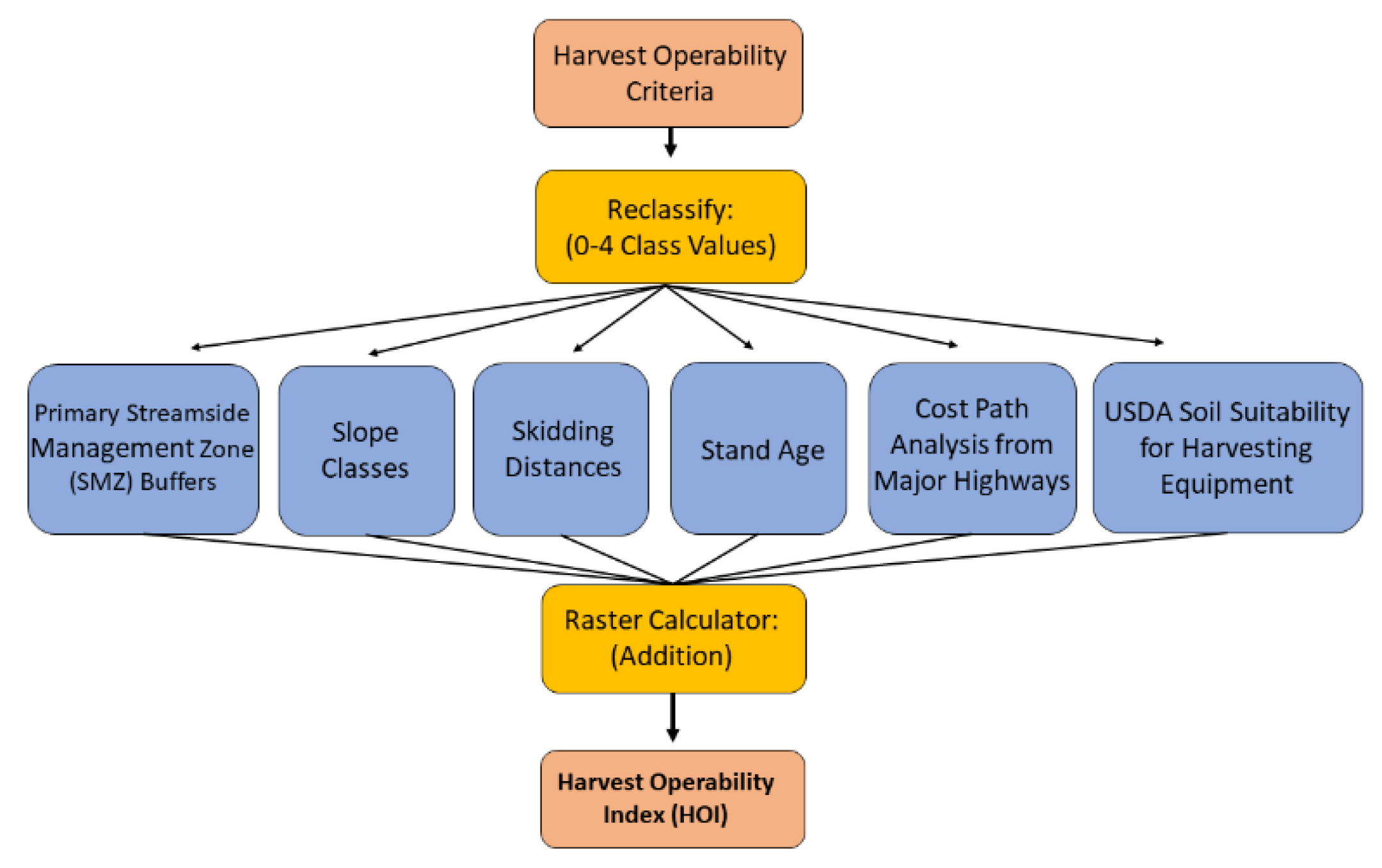
2.1. HOI Model Overview

Our HOI model reclassifies six HOI criteria to a 0–4 class value scale. A zero-class value defines low operability for wheel-based harvesting equipment in each HOI criterion. The scale increases linearly in operability, with a four-class value representing the highest operability in each HOI criterion. After reclassification, the six HOI criteria are added together using Raster Calculator addition to generate a numeric scale of harvest equipment operability (Figure 1). This scale of 0–4, rather than a typical 1–5, was chosen for its ability to preserve the final HOI model scale as 0–24 after Raster Calculator addition, rather than having an HOI model ranging from 6–30 for ease of interpretation. We chose a class value schema with a 5-bin structure (i.e., 0–4) for its balance between several levels of operability and distinct value differences from one bin to the next. Additionally, this class value scale can be prioritized differently based on a manager’s needs in their specific study area of concern. As such, the HOI model can be used as a flexible DSS in many different areas.
For the Slope HOI criterion, a Slope Exclusion Zone was also created which ensured any areas exceeding 40% slope grade received a 0 HOI score, regardless of other HOI criteria in the area, due to the safety and production limits this terrain has on wheel-based equipment operation. All six model criteria are added together with equal weight, with no data layer attributing more importance over another. The final HOI output has a range of 0–24 for its possible values. Low HOI values correspond to a poorly suited area for harvest equipment operation, whereas high HOI values correspond to a highly optimal area for harvest equipment operation. For further ease of reporting and interpretation, our final HOI model output in Jocassee was also converted to a 1–5 operability scale using the Rescale by Function (Large) Spatial Analyst Tool. This result was then reclassified to develop the final 0–5 HOI categorical operability classes for reporting (Table 1). In this reclassification schema, a 0 defined the Slope Exclusion Zone and values between 1 and 1.5 defined (1: Very Poor Operability). Values of 1.5 to 2.0 defined (2: Poor Operability) and values between 2.0 and 3.0 (3: Moderate Operability). Lastly, values between 3.0 and 4.0 defined (4: Good Operability) and values between 4.0 and 5.0 (5: Very Good Operability).

2.2. Study Area

Jocassee Gorges NRA retains 13,118 ha of forest area managed by the South Carolina Department of Natural Resources (SCDNR) in the Upstate of South Carolina, USA (34.944530, −82.918152) (Figure 2). Jocassee is primarily comprised of acidic sandy/clay or sandy/loam soils [37]. The terrain is characteristic of the Southern Blue Ridge Escarpment and is marked by convex nose slopes, stream gorges and ravines. Elevation ranges from 350–850 m and slopes range from 20–70% grade [37,38]. Jocassee also possesses tracts of planted loblolly pine (Pinus taeda L.), primarily at lower elevations in the southwest. These stands have a history of recent harvesting activity and are where the bulk of harvesting currently occurs. The most dominant silvicultural prescriptions for harvesting in Jocassee are dormant season clear-cutting, selective thinning, and some shelterwood harvesting. Outside of SMZs, there are no limitations on allowable cut volume. The overstory of Jocassee is comprised mostly of red maple (Acer rubrum L.), yellow-poplar (Liriodendron tulipifera L.) and various Oak species (Quercus L. sp.) [38].

2.3. Data Sets Used in the Harvest Operability Index (HOI)

The HOI was constructed using ArcMap 10.7 ModelBuilder [39]. Due to the popularity of wheel-based skidders and feller-bunchers in the Southeastern USA and Southern Appalachians [2,3], our modeling initiatives used wheel-based harvesting systems and their operational constraints to reflect the preferred equipment in our case study area. We acquired data layers for the HOI from a variety of sources, including GIS data from Jocassee staff and publicly available US Census, hydrology, elevation, and soil data (Table 2). Within Jocassee, “Access Roads” defined unpaved and dirt roads that are multi-purpose. These roads are used typically used for forestry operations, prescribed fire operations, and public recreational activity. In contrast, “Roads” defined asphalt paved highways, streets, and rural roads that are typically not used for forest operations beyond the transport of equipment and wood materials. Our model did not include skid trails as access roads are a major component of the skid trail network in Jocassee and are often used for skidding during harvests. Each data layer was used to generate six unique HOI criteria which were then used in the final HOI model.

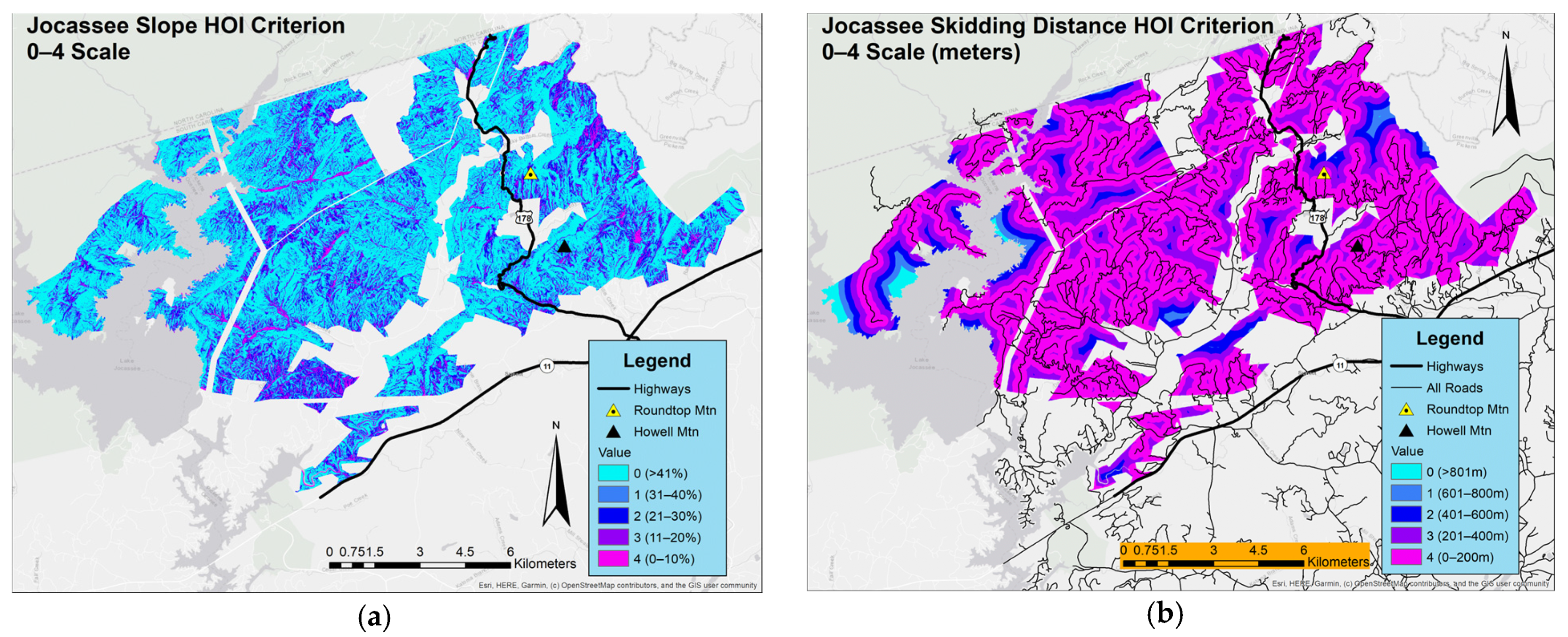
2.4. Slope HOI Criterion Methodology

Two 3.048 m2 cell size Digital Elevation Models (DEMs) of Pickens and Oconee Counties were obtained from the SCDNR [40]. These DEMs were subsequently mosaiced together and clipped to the study area to form the DEM data layer. We calculated the percent slope from this DEM data layer for the first HOI criterion using the Spatial Analyst Slope Tool. The slope was then reclassified in 10-percent interval break classes (Table 3). Our literature review found 0–20% presenting optimal conditions for wheeled equipment, such as harvesters, grapple skidders and tractors [9,10,11,30], and slopes of 30–40% resulting in severe productivity costs and machine dysfunction [6,10,12,30,31]. Our model used 10-percent breaks to denote decreasing machine operability, as 10 percent was the upper limit of the most optimal slope conditions found for harvesting equipment [41] and was used in other GIS terrain analyses [9]. Slopes in the 0-class value (40% or greater) were excluded from the HOI analysis by setting this criterion to “NoData” before the final HOI raster calculator step. This created a “Slope Exclusion Zone”, wherein any area marked by a 40% or greater slope grade was designated as a 0 HOI value- irrespective of other HOI criteria within that area. This ensured steep-sloped areas, which pose severe safety and productivity limits for wheel-based harvesting equipment, always received an inoperable rating of a 0 HOI value.

2.5. Skidding Distance HOI Criterion Methodology

The Skidding Distance HOI criterion served as a metric in the HOI for defining the most operable (in terms of machine productivity), and therefore most likely cost-effective, distances for a wheel-based skidder. Our road layer used for the Skidding Distance HOI Criterion included a shapefile from US Census TIGER/Line® road shapefiles for Pickens Co. [42], merged with a Jocassee access road shapefile obtained from Jocassee staff. A Spatial Analyst Euclidean Distance Tool, using the shapefile of merged roads as its source input, then calculated distance in meters from the merged road shapefile. Our modeling initiatives assumed skidders are allowed to move freely throughout forest stands from starting points along the road network. The Euclidean distance output was then reclassified following metrics for optimal skidding conditions found in literature, with 0–200 m from a road representing the highest value (4 class value) [28,29,43]. Subsequent break classes used a 200 m interval to define decreasing skidding distance suitability, with >800 m receiving the lowest value (0 class value) (Table 3) due to substantially decreased machine productivity [44].

2.6. Cost Distance to Highways HOI Criterion Methodology

The Cost Distance to Highways HOI criterion was then generated using the Spatial Analyst Cost Distance Tool and the Pickens Co. US Census Roads and Jocassee Access Roads data layers. The Cost Distance to Highways HOI criterion’s role in the HOI was to define areas of high and low operability for logging trucks based on the road network within and around forest stands (i.e., accessibility) and their proximity to major highways for the ultimate purpose of transporting wood materials off-site. This metric for operability assumed areas nearest to major highways would result in lower harvesting costs due to increased productivity. For example, landing sites near major highways could reduce travel times for logging trucks by limiting travel on forest road networks. Additionally, skidders can haul timber closer to major highways, further limiting travel for logging trucks on forest road networks. First a “Road Accessibility” cost raster was rendered, which served as the input cost raster for a Cost Distance analysis. Cost Distance calculates the cost to move planimetrically through cells with an assigned integer cost value from a source destination. Calculations are a multiplier process, wherein cell size is multiplied by the final cost output per cell, determined by node and link cell representation [45]. To begin the Cost Distance process, our road data layers (containing Jocassee access roads along with US Census Pickens Co. road data) was split into two shapefiles: a paved road shapefile (asphalt pavement including residential, highways, and major roads) and an unpaved road shapefile (all major dirt roads and unpaved access roads). In the study area, only five Jocassee access roads within Oconee Co. appeared in the boundary of Jocassee. Thus, no Oconee Co. US Census road data were needed.
These two shapefiles were then converted into two raster layers on a 1–10 scale. Paved roads, (including all highways, rural roads and residential paved streets) received the lowest cost (1), unpaved roads (i.e., access roads) the median cost (5), and roadless areas the highest cost (10). These raster layers were then combined using a raster calculator to create the final 1–10 cost raster. Our reasoning for this 1–10 raster reclassification assumed the least costly logging truck movement and accessibility was on paved roads, with unpaved roads assuming the median value and roadless areas attributing the worst cost for logging truck movement and accessibility. This data layer was used as the cost raster input for the Cost Distance Tool. The source input used in the analysis was a merged SC Highway 11 and U.S. Highway 178 polyline feature, generated from the US Census Pickens Co. Roads shapefile. This feature was chosen as the source input for the Cost Distance, based on assumptions landing and harvest sites near the two highways within Jocassee should be prioritized due to lower wood transportation costs associated with greater logging truck speed [46]. The Cost Distance Tool then calculated the cost distance from the SC Highway 11 and U.S. Highway 178 polyline feature across each pixel value of the cost raster layer of paved, unpaved, and roadless areas. This output was reclassified into a 0 to 4 class value scale to generate the Cost Distance to Major Highways HOI criterion (Table 3).

2.7. Stand Age HOI Criterion Methodology

The Stand Age HOI Criterion’s role in the HOI model was to define optimal operability in areas where timber volume was more likely to be higher- thus increasing machine productivity and profitability. Since timber volume estimates were not available for the entirety of Jocassee, we used stand age as a surrogate for timber volume as this metric was available across the entire study area. By including a stand age criterion in the HOI, we factored in areas that are more favorable for harvesting operation due to increased production capacity with greater merchantable volume. The forest stand shapefile, obtained from Jocassee staff, was used to develop a stand age raster layer from the tabular data. The stand age raster was reclassified to have stands >60 years as the highest suitability (4 class value), with open areas and young stands of <10 years having the lowest suitability (0 class value) (Table 3). Our reclassification followed the general trend of older stands containing more merchantable volumes on average than younger ones [47].

2.8. SMZ HOI Criterion Methodology

The SMZ HOI criterion served as a metric to define operability based on the presence of waterbody features and state regulations around them. By defining low operability within Primary (Streamside Management Zone) SMZ buffers, the SMZ HOI criterion accounts for areas where overall costs are associated with any erosion control efforts and leaving required residual standing timber (15.24 m2 BA in the state of SC) in the Primary SMZ of perennial streams are lessened. Additionally, this layer defines Primary SMZs to have limited accessibility for harvesting equipment due to erosion risks to water bodies. Shapefiles of stream and waterbody features of the study area were obtained from the US Geologic Survey National Hydrography Dataset (NHD) [48]. After acquiring these data sets and clipping them to the study area, selections were made to generate two shapefiles: trout waters and non-trout waters. Selections were informed by the SC Trout Fishing Guide [49]. Primary SMZs were generated from these shapefiles using SC state guidelines [50]. In streams and lakes designated as non-trout waters, buffers of 12.19 m (40 ft) were created around these features. In streams and lakes designated as trout waters, a buffer of 24.38 m (80 ft.) was created (Table 2). The Primary SMZ buffers were then converted into rasters and merged together into a single raster layer before being reclassified. Equipment operation in the Primary SMZ buffers presents a greater risk for water contamination and following BMP guidelines can increase costs for loggers in the Appalachians [22,23,24]. Thus, in our reclassifications, we valued areas within an SMZ buffer to have the lowest suitability (0 class value), and the areas beyond a buffer have the highest suitability (four class value) (Table 3) as BMP restrictions ease with increasing distance away from the Primary SMZ and in gentler slope terrain.

2.9. Soil Suitability HOI Criterion Methodology

The Soil Suitability HOI criterion’s role in the HOI was to define low operability in poorly suited soils for harvesting equipment operation. Poorly suited soil areas could be prone to compaction, rutting, and equipment slippage. In this way, poorly suited soil areas could decrease machine productivity and raise costs associated with road amelioration, machine-related downtime, or erosion mitigation efforts. Additionally, since this layer defines limited accessibility for harvesting equipment in poorly suited soils, it simultaneously mitigates erosion risks from equipment operation. A shapefile of soil map units for the extent of Jocassee was obtained from the SSURGO database [51]. We amended the tabular data of this shapefile, so each map unit polygon of soil type corresponded to its Land Management Rating for Harvest Equipment Operability found in the custom SSURGO soil report of our study area. This tabular data was then converted to a raster-based on Harvest Equipment Operability qualitative metrics. Harvest Equipment Operability rates each soil classification in a given area on a 3-tier qualitative scale: poor suitability, moderate suitability, and well suited. The ratings for each soil classification are based on slope, soil plasticity index, sand content, water table depth, and ponding among others [51]. The harvest equipment operability raster was reclassified with the following values: poor suitability (0 class value), moderate suitability (2 class value), and well suited (4 class value) (Table 3).

2.10. HOI Model Validation

To assess the HOI model performance, we compared the Rescaled by Function HOI results with known previously clear-cut harvesting areas. Using National Agriculture Imagery Program (NAIP) imagery from 2019 [52], we outlined 10 polygons around known clear-cut areas at a scale of 1:5000. We then calculated the mean HOI score in each of these mapped clear-cut areas using the Spatial Analyst Zonal Statistics tool, similar to other GIS modeling validations [53]. Scores between 3.5–5 were considered to be the most optimal HOI values.

3. Results

3.1. HOI Criteria Class Value Results

Upon reclassification of the Slope HOI criterion, 60% (7824 ha) of Jocassee was in the Slope Exclusion Zone and received a 0-class value (Figure 3a). Gentle slopes of 4-class values, and therefore high operability, were mainly confined to the south of Jocassee and in portions of the east and represented 2% (341 ha) of the land area. The Skidding Distances HOI criteria showed a well-established road network and highly operable conditions for skidding distances within Jocassee, as 4-class values represented 73% (9546 ha) of land area for this criterion (Figure 3b). Zero-class values (i.e., where skidding distances exceeded 800 m) represented <1% (110 ha) of Jocassee and were primarily observed in the west and northeast. As predicted, the Cost Path to Major Highways HOI criteria delineated highly operable 4-class values near SC 11 and US 178 (Figure 3c). This class value represented 6% (822 ha) of the Jocassee land area. In contrast, 60% (8024.4 ha) of Jocassee corresponded to a 0-class value for this criterion.
The Stand Age HOI criterion illustrated 78% (10,174 ha) of Jocassee was dominated by median (2) class values for stand age (Figure 3d). The oldest stands represented 3% (508 ha) of Jocassee and were located primarily in the south and west. The Soil Suitability HOI criterion illustrated 76% (9918 ha) of Jocassee had a 0-class value for soil suitability for harvest equipment operation (Figure 3e). Areas of 4-class values were scattered and isolated in Jocassee and represented 3% (456 ha) of the land area. Lastly, the SMZ HOI criterion revealed the vast majority of Jocassee was of high operability from an SMZ standpoint as 95% (12,501 ha) of Jocassee received a 4-class value for this criterion (Figure 3f). Only 4% (617 ha) received the lowest class value of 0, with the densest concentrations of SMZ buffers being primarily observed in the south of Jocassee.

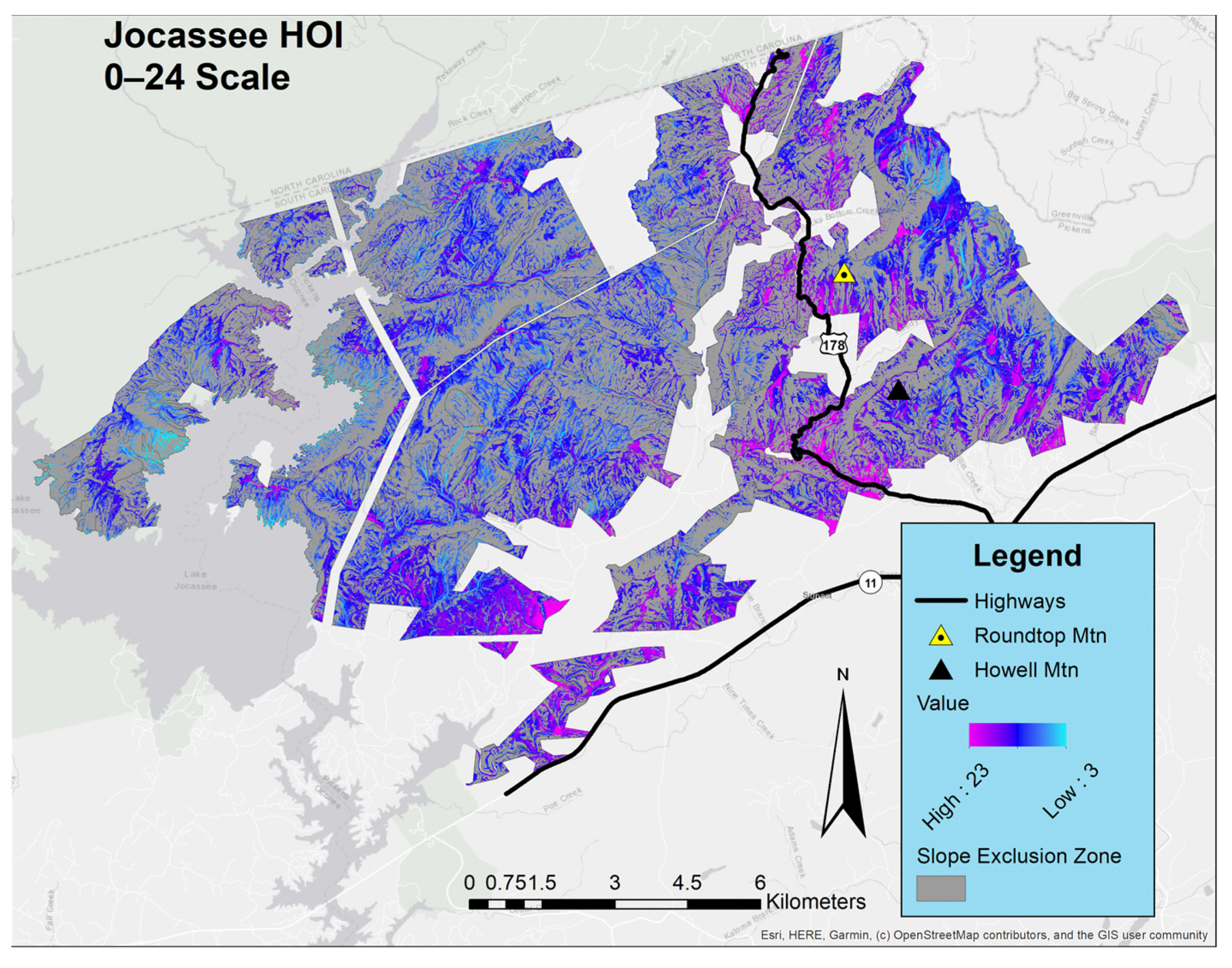
3.2. HOI Model Results

Our HOI model output for Jocassee had a range of HOI values from 3–23. No area within Jocassee attained the absolute highest (i.e., best equipment operability) HOI value of 24 (Figure 4). Upon reclassification to a 5-tier scale (Figure 5), 60% (7824 ha) of Jocassee managed forest area fell within the Slope Exclusion Zone (Table 4). In contrast, Very Good Operability values corresponded to 10% (1381 ha) of Jocassee. Good Operability values represented the second greatest land area at 18% (2442 ha). Overall, our model showed the difficulty of wheel-based mechanized harvesting in Jocassee as Good Operability and Very Good Operability values were approximately 28% (3823 ha) of the land area. The model delineated continuous blocks of Good Operability and Very Good Operability near US HWY 178 and southwest of Howell and Roundtop Mtn (Figure 5). In these areas, there has been no recent harvesting activity, and these would be ideal locations for considering timber harvesting projects to meet ecological restoration objectives (i.e., reduce the basal area for an open canopy structure). Other large blocks of contiguous Good and Very Good operability area were generally concentrated in the south of Jocassee near where most active logging occurs.

3.3. HOI Model Validation Results

Our model validation showed the HOI was successful at delineating highly operable areas for timber harvesting due to the mean HOI scores present within the 10 selected harvesting clear cuts (Table 5). These clear-cut areas ranged in size from 0.18–4.90 ha and were generally clustered around the southwest of Jocassee, with two clear-cut areas occurring in the central west of Jocassee near Highway 178.

4. Discussion

The HOI outputs in Jocassee reflect the challenges of this landscape in terms of timber harvest operations. Despite having a well-established network of logging roads and large acreage of older age class stands, the area is marked by steep slopes with many gorges and ravines [37,38]. Like other GIS modeling approaches, our analysis incorporated similar data criteria from other studies which defined suitable areas for harvesting equipment operation in mountainous terrain. Chief among these was slope, which was a common data criterion used in other GIS models [7,8,9]. A waterbody analysis was used by Pecora and others [30] in their modeling techniques, but these researchers used river presence/absence in addition to classes based on river length. Instead, the HOI model waterbody analysis incorporated SMZ buffers in both trout and non-trout designated waters. By incorporating a BMP criterion specific to the case study region, the HOI better-reflected harvesting operations in South Carolina. Cost distance techniques were used by Pellegrini [8] in a GIS model for forest accessibility. This model accounted for operative road class in addition to operator traveling time to define accessibility. In contrast, the HOI model used a cost distance analysis based on road networks surrounding two state highways in the Jocassee study area. This allowed us to define accessibility based on minimal cost distance to highways, as greater speed limits allow for faster transportation of wood materials off-site.
In the United States, Adams and others [7] assessed terrain risks in SW Virginia using slope classes, soil compaction, and debris slide risk to identify proper harvesting equipment in 500 ha of a mountainous landscape. However, this analysis focused on identifying ideal harvesting systems based on these factors alone and did not account for other harvesting factors which our HOI model captured (such as SMZ buffers, skidding distances, and stand age). Other GIS modeling approaches in mountainous terrain in the United States have focused more on forest operation logistics including cost-mitigation for forest road management [35] and projections of transportation costs and biomass availability for bioenergy facilities [54]. The HOI model incorporates some logistic considerations with its inclusion of stand age and cost distance from major highways data criteria. By including these criteria, the HOI model adds additional information to a terrain suitability analysis. This allows for other harvest considerations to inform the suitability model, creating a holistic model that incorporates logistic and terrain constraints for wheel-based equipment operations.
The HOI introduces another GIS suitability modeling technique to be used as a decision support tool for forest management planning. By combining multiple harvesting operability criteria in one model, the HOI effectively delineates the most suitable area where harvesting costs are likely to be low based on numerous operability factors that could raise costs for equipment operation (e.g., steep slopes and long skidding distances that decrease machine productivity, increased distance from major roads for wood hauling purposes). The HOI fills a void of GIS harvest equipment suitability models in the Eastern United States, especially in the Southern Appalachians and Southern Blue Ridge Escarpment, as GIS equipment suitability models here are scarce. The outputs of the HOI model can also aid in determining suitable areas for equipment operation and timber harvests for fire-dependent forest ecological restoration, effectively pointing to areas of interest to conduct further field assessments to confirm highly suitable areas. This follows recommendations and discussion points found in other GIS models [7].
In Jocassee, the HOI pointed to forested areas near US HWY 178 and southwest of Howell Mtn as optimal areas for wheel-based harvesting equipment operation. As these areas have no recent logging history, they would be a high priority for investigation of future harvesting for fire-dependent forest ecological restoration. The construction of the HOI in ModelBuilder allows for easy replication in other mountainous regions, as other forestry practitioners can exchange our input data layers to utilize their own DEMs, stream layers, case study shapefiles, and road data. Users of the HOI in other US states can also define the SMZ buffers which pertain to their state’s regulations in the reclassification steps of the HOI. Similarly, users can also define their own class values for each HOI criterion to better reflect their unique study area. The HOI’s reliance on publicly available data also reduces the amount of time required for data collection and acquisition, making the model faster and easier to generate- thus improving its accessibility.
Our HOI criteria selections could pose limitations in the overall HOI model outputs. For example, our Skidding Distance HOI criterion could be augmented with the inclusion of skid trails, thus improving the overall accessibility of forest stands in our study area. However, within Jocassee skid trail data was not available for all forest stands. Furthermore, access roads in Jocassee are used extensively for harvest operations and serve as skid trails. In our Cost Distance HOI criterion, we did not account for distance to mills from the study area location. Including distances to mills surrounding the study area in the Cost Distance HOI criterion could more accurately reflect operability for logging trucks. Our Stand Age HOI criterion could also be improved by evaluating metrics that pertain more directly to timber harvest operations. For example, this could be defining a 0–4 class scale for timber product classes (e.g., pulpwood, sawtimber, veneer, etc.), species composition, and timber volume. However, our HOI criterion selection was made based on the most comprehensive timber inventory (stand age) GIS data available around our study area. The HOI’s overall scope is to provide a meaningful delineation of timber harvest operability based on a balance of harvesting logistics and equipment operability. Our HOI criterion selections were within the bounds of this scope and have the added benefit of utilizing publicly available data which improves the HOI’s accessibility for various managers and researchers.
There are considerations to be noted which could augment the HOI model’s performance and/or provide further analysis for different harvesting considerations. In consultation with experts, both in workshop settings and through Analytical Hierarchy Processes (AHP), GIS land suitability models have been produced which are guided by the knowledge of experts with the addition of criteria weights [35,55,56,57,58,59,60]. The outcome of a model with weighted data criteria informed by regional timber harvesting experts could be beneficial for the final HOI values. An AHP analysis with harvesting practitioners and foresters could reduce the prominence of median HOI values- subsequently identifying more operable areas for harvesting in Jocassee. Alternatively, this process could potentially reduce the high harvesting operability area, and generate a model output with a greater land area devoted to lower HOI values.
The HOI model could also incorporate analyses for alternative mechanized harvesting equipment. Other GIS analyses have demonstrated how cable-crane systems and wheel track skidders can improve slope operability beyond 30%, thus increasing the suitable area for equipment operation [7,8,9]. There is potential to augment the HOI model by incorporating parameters for track skidders and cable-yarding systems. However, around the case study area, this equipment is not commonly used. This is primarily due to the lower costs associated with wheel-based harvesting systems over track equipment [7,13] and the lack of experience in the Appalachian region with cable yarding systems [13]. For areas outside of the Southern Blue Ridge Escarpment, including these machines in an HOI analysis could be useful.
In their GIS analysis, Hogland and others [54] used Forest Inventory and Analysis (FIA) plot data, function modeling, and NAIP datasets to estimate Basal Area per Acre (BAA), Aboveground Biomass (AGB), and Trees per Acre (TPA) across 8 million hectares. Using these techniques could also improve the use of the HOI model. Managers may not have access to extensive forest stand age data and substituting the stand age data criterion for a BAA or TPA criterion could alleviate this dilemma. Additionally, estimating BAA or TPA may be more valuable for managers. In the reclassification of class values, managers could define their own 0–4 scale class value metrics based on regional harvesting demands and/or quotas. Lastly, modeling of predicted BAA, TPA, or AGB could be more representative of the actual board feet within a stand as stand age in the HOI model is a surrogate for a timber volume assessment. However, this technique requires more data layers to be acquired and further GIS analysis with landcover classification and regression analysis to create the BAA, TPA, or AGB layers- thus creating more time devoted to data criterion construction. A simpler approach, if the data is available, would be to retain the stand age HOI data criterion or use stand volume/basal area from forest stand inventory data.
Our six HOI criteria for Jocassee were ultimately chosen in part for their ability to provide a meaningful balance between equipment constraint and harvesting logistic considerations for wheel-based harvesting operability within the entire extent of the study area. However, the HOI is not bound by these six criteria. The framework of the HOI lends a user a practical way to swap or add additional logging and harvesting criteria into the HOI based on their landscape and needs. By defining their own 0–4 class value scale, the HOI can incorporate numerous other criteria including, but not limited to, distance to mills, cutting density, time of harvest to reflect seasonal changes in soil properties, and forest road conditions. Effectively, other forest managers and researchers can harness the HOI to define HOI outputs that more aptly suit their specific harvesting operability needs.
The HOI offers forest managers a way to balance equipment operation constraints with harvesting logistic considerations in a holistic GIS model. The outputs can better help to prioritize harvest operations to promote the better allocation of valuable time, equipment and labor resources. This model can also be integrated with other GIS management decisions, such as identifying and prioritizing highly operable areas to conduct fuel thinning or ecological restoration harvests.

5. Conclusions

The HOI model is a decision support tool for guiding timber harvesting in mountainous areas based on the suitability for wheel-based equipment operation, as unfavorable mountainous terrain can greatly impede this machine activity. By numerically rating a landscape in a given study area, the HOI model can be used as a tool to inform harvest decision-making for the benefit of loggers and managers at a large landscape scale. By targeting highly operable areas for timber harvesting, managers can prioritize resources toward areas that minimize overall harvesting operation costs, all while avoiding areas that may lead to equipment damage, higher operating costs, or soil and water degradation. The HOI can also be integrated into other forest management decisions, such as harvesting in fire-dependent forests for ecological restoration and fuel reduction.
Our simple modeling approach can be easily applied to other areas with mountainous terrain by swapping inputs in ModelBuilder, in order for forest managers to better understand harvest limitations in their particular management area. The HOI also presents a GIS modeling approach that also fills a scarcity of GIS harvesting equipment suitability in the Eastern United States, especially in the Southern Appalachians and Southern Blue Ridge Escarpment. Future research with the HOI in its case study area could include workshops with Southern Blue Ridge Escarpment timber and forest management practitioners to promote HOI outputs informed by the needs and experience of Southern Blue Ridge Escarpment timber harvesting experts. The HOI could also incorporate analyses based on different equipment operations, such as wheel track skidders and cable crane systems.

Author Contributions

K.P. wrote and prepared the manuscript in addition to conducting the GIS analyses. K.P. and P.H. were responsible for the GIS conceptualization and methodology behind the HOI model. D.H., A.H.H., and P.H. all provided comments, edits, and suggestions on drafts of this article. All authors discussed results and edits during the manuscript writing process. All authors have read and agreed to the published version of the manuscript.

Funding

This research was funded and supported by the South Carolina DNR and the Foothills Community Foundation’s Keowee-Toxaway Habitat Enhancement Program.

Data Availability Statement

Data presented in this study is available upon request from the corresponding author. The data is not publicly available due to the use of Jocassee road and forest stand data which is shared on a case–by–case basis.

Acknowledgments

This research was conducted on the ancestral homeland of the Cherokee People and we acknowledge the legacy of the Indian Removal Act and the Trail of Tears. Many thanks must also be given to Mark Hall of the SCDNR, who provided logistic and technical support for this research.

Conflicts of Interest

The authors declare no conflict of interest.

References

  1. Lindroos, O.; La Hera, P.; Häggström, C. Drivers of Advances in Mechanized Timber Harvesting—A Selective Review of Technological Innovation. Croat. J. For. Eng. 2017, 38, 243–258. [Google Scholar]
  2. Conrad, J.L.; Greene, W.D.; Hiesl, P. A Review of Changes in US Logging Businesses 1980s–Present. J. For. 2018, 116, 291–303. [Google Scholar] [CrossRef]
  3. Conrad, J.L.; Greene, W.D.; Hiesl, P. The Evolution of Logging Businesses in Georgia 1987–2017 and South Carolina 2012–2017. For. Sci. 2018, 64, 671–681. [Google Scholar] [CrossRef]
  4. Allen, C.D.; Savage, M.; Falk, D.A.; Suckling, K.F.; Swetnam, T.W.; Schulke, T.; Stacey, P.B.; Morgan, P.; Hoffman, M.; Klingel, J.T. Ecological Restoration of Southwestern Ponderosa Pine Ecosystems: A Broad Perspective. Ecol. Appl. 2002, 12, 1418–1433. [Google Scholar] [CrossRef]
  5. United States Forest Service, United States Department of Agriculture. Increasing the Pace of Restoration and Job Creation on Our National Forests. Available online: https://www.fs.usda.gov/sites/default/files/legacy_files/media/types/publication/field_pdf/increasing-pace-restoration-job-creation-2012.pdf (accessed on 5 December 2021).
  6. Heinimann, H.R. Ground-based Harvesting Technologies for Steep Slopes. In Proceedings of the International Mountain Logging and 10th Pacific Northwest Skyline Symposium, Corvallis, OR, USA, 28 March–1 April 1991; Sessions, J., Chung, W., Eds.; Department of Forest Engineering, Oregon State University: Corvallis, OR, USA; pp. 1–19. [Google Scholar]
  7. Adams, J.D.; Visser, R.M.; Prisley, S.P. Modeling steep terrain harvesting risks using GIS. In Proceedings of the Austro2003: High Tech Forest Operations for Mountainous Terrain, Schlaegal, Austria, 5–9 October 2003; pp. 1–13. [Google Scholar]
  8. Pellegrini, M. Support Tools for Planning and Management of a Forest Road Network. Ph.D. Thesis, Universita Degli Studi di Padova, Padua, Italy, 2012. Available online: http://paduaresearch.cab.unipd.it/4454/ (accessed on 3 March 2021).
  9. Mreže, P.; Cesta, Š.; Planskoj, S.U.; Anbarda, J. Evaluation of Forest Road Network and Determining Timber Extraction System Using GIS: A Case Study in Anbardag Planning Unit. Sumarski 2017, 383, 163–171. [Google Scholar]
  10. Diniz, C.C.C.; Nakajima, N.Y.; Robert, R.C.G.; Dolácio, C.J.F.; da Silva, F.A.; Balensiefer, D.F. Performance of grapple skidder in different ground inclinations. Floresta 2019, 49, 41–48. [Google Scholar] [CrossRef] [Green Version]
  11. Lotfalian, M.; Fallah, A.; Moafi, M.; Nobakht, A. Determining the maximum allowable cross slope of skid trails for rubber-tired skidder Timberjack 450C. Ann. Biol. Res. 2012, 3, 3805–3810. [Google Scholar]
  12. Đuka, A.; Poršinsky, T.; Pentek, T.; Pandur, Z.; Vusić, D.; Papa, I. Mobility range of a cable skidder for timber extraction on sloped terrain. Forests 2018, 9, 526. [Google Scholar] [CrossRef] [Green Version]
  13. Haynes, H.; Visser, R. Productivity Improvements through Professional Training in Appalachian Cable Logging Operations. In Proceedings of the International Mountain Logging 11th Pacific Northwest Skyline Symposium, Seattle, WA, USA, 10–12 December 2001; pp. 48–55. [Google Scholar]
  14. Holzfeind, T.; Kanzian, C.; Stampfer, K.; Holzleitner, F. Assessing cable tensile forces and machine tilt of winch-assisted forwarders on steep terrain under real working conditions. Croat. J. For. Eng. 2019, 40, 281–296. [Google Scholar] [CrossRef] [Green Version]
  15. Kolka, R.; Smidt, M. Effects of forest road amelioration techniques on soil bulk density, surface runoff, sediment transport, soil moisture and seedling growth. For. Ecol. Manag. 2004, 202, 313–323. [Google Scholar] [CrossRef]
  16. Page-Dumroese, D.S.; Jurgensen, M.F.; Tiarks, A.E.; Ponder, F.; Sanchez, F.G.; Fleming, R.L.; Kranabetter, J.M.; Powers, R.F.; Stone, D.M.; Elioff, J.D.; et al. Soil physical property changes at the North American Long-Term Soil Productivity study sites: 1 and 5 years after compaction. Can. J. For. Res. 2006, 36, 551–564. [Google Scholar] [CrossRef]
  17. Wang, J.; Ledoux, C.B.; Edwards, P.; Jones, M. Soil bulk density changes caused by mechanized harvesting: A case study in central Appalachia. For. Prod. J. 2005, 55, 37–40. [Google Scholar]
  18. Martin, C.W.; Hornbeck, J.W. Logging in New England need not cause sedimentation of streams. North. J. Appl. For. 1994, 11, 17–23. [Google Scholar] [CrossRef]
  19. Reisinger, T.W.; Simmons, G.L.; Pope, P.E. The impact of timber harvesting on soil properties and seedling growth in the south. South J. Appl. For. 1988, 12, 58–67. [Google Scholar] [CrossRef]
  20. Wang, J.; LeDoux, C.; Vanderberg, M.; Li, Y. Effects of Soil Compaction on Residual Stand Growth in Central Appalachian Hardwood Forest: A Preliminary Case Study. In Proceedings of the 29th Council of Forest Engineering Conference, Coeur d’Alene, ID, USA, 30 July–2 August 2006; pp. 333–341. [Google Scholar]
  21. Zenner, E.K.; Fauskee, J.T.; Berger, A.L.; Puettmann, K.J. Impacts of skidding traffic intensity on soil disturbance, soil recovery, and aspen regeneration in North Central Minnesota. North. J. Appl. For. 2007, 24, 177–183. [Google Scholar] [CrossRef] [Green Version]
  22. Shaffer, R.M.; Haney, H.L.; Worrell, E.G.; Aust, W.M. Forestry BMP implementation costs for Virginia. For. Prod. J. 1998, 48, 27–29. [Google Scholar]
  23. Kilgore, M.A.; Blinn, C.R. Encouraging the application of sustainable timber harvesting practices: A review of policy tool use and effectiveness in the eastern United States. Water Air Soil Pollut. Focus 2004, 4, 203–216. [Google Scholar] [CrossRef]
  24. Sawyers, C.; Aust, W.M.; Bolding, M.C.; Lakel, W.A., III. Effectiveness and costs of Overland Skid Trail BMPS. In Proceedings of the 16th Biennial Southern Silvicultural Resource Conference, Charleston, SC, USA, 15–17 February 2011; pp. 283–289. [Google Scholar]
  25. Jodlowski, K.; Kalinowski, M. Current possibilities of mechanized logging in mountain areas. Leśne Prace Badawcze 2018, 79, 365–375. [Google Scholar] [CrossRef] [Green Version]
  26. Adebayo, A.B.; Han, H.; Johnson, L. Productivity and cost of cut-to-length and whole-tree harvesting in mixed-conifer stand in northern Idaho. In Proceedings of the 29th Council on Forest Engineering Conference, Couer d’Alene, ID, USA, 22 July–2 August 2006; pp. 127–136. [Google Scholar]
  27. Jirousek, R.; Klvac, R.; SkoupY, A. Productivity and costs of the mechanized cut-to-length wood harvesting system in clear-felling operations. J. For. Sci. 2007, 53, 476–482. [Google Scholar] [CrossRef] [Green Version]
  28. Hiesl, P.; Benjamin, J.G. Harvesting Equipment Cycle Time and Productivity Guide for Logging Operations in Maine; Miscellaneous Publication 762; Maine Agricultural and Forest Experiment Station: Orono, ME, USA, 2013; pp. 1–67. ISSN 1070-1508. [Google Scholar]
  29. Petković, V.; Marčeta, D.; Ljubojević, D.; Kuburić, J. Determination of Average Skidding Distance Using GIS. Nova Mehanizacija Šumarstva 2017, 38, 33–42. [Google Scholar]
  30. Pecora, G.; Todaro, L.; Moretti, N. Optimization of Timber Harvesting System Using GIS-Based System. In Proceedings of the Second International Congress of Silviculture, Florence, Italy, 26–29 November 2014; pp. 892–895. [Google Scholar]
  31. Davis, C.J. Evaluating Terrain for Harvesting Equipment Selection. Int. J. For. Eng. 1990, 2, 9–16. [Google Scholar] [CrossRef]
  32. Becker, R.M.; Keefe, R.F.; Anderson, N.M.; Eitel, J.U.H. Use of lidar-derived landscape parameters to characterize alternative harvest system options in the Inland Northwest. Int. J. For. Eng. 2018, 29, 179–191. [Google Scholar] [CrossRef]
  33. Picchio, R.; Pignatti, G.; Id, E.M.; Latterini, F.; Benanchi, M.; Foderi, C.; Venanzi, R.; Verani, S. The Application of Two Approaches Using GIS Technology Implementation in Forest Road Network Planning in an Italian Mountain Setting. Forests 2018, 9, 277. [Google Scholar] [CrossRef] [Green Version]
  34. Picchio, R.; Latterini, F.; Mederski, P.S.; Tocci, D.; Venanzi, R.; Stefanoni, W.; Pari, L. Applications of GIS-Based Software to Improve the Sustainability of a Forwarding Operation in Central Italy. Sustainability 2020, 12, 5716. [Google Scholar] [CrossRef]
  35. Dodson, E.M.; Chung, W.; Mills, K.; Nall, R.; Sessions, J.; Zartman, G. Planning to determine low-volume road standards, long-term needs, and environmental risks and trade-offs. Transp. Res. Rec. 2007, 1, 11–19. [Google Scholar] [CrossRef]
  36. Simon, S.A. Ecological Zones in the Southern Blue Ridge: 4th Approximation; Report; Ecological Modeling and Fire Ecology Inc.: Asheville, NC, USA, 2015. [Google Scholar]
  37. Abella, S.R.; Shelburne, V.B.; MacDonald, N.W. Multifactor classification of forest landscape ecosystems of Jocassee Gorges, southern Appalachian Mountains, South Carolina. Can. J. For. Res. 2003, 33, 1933–1946. [Google Scholar] [CrossRef]
  38. Boyle, M.F.; Abella, S.R.; Shelburne, V.B. An ecosystem classification approach to assessing forest change in the southern Appalachian Mountains. For. Ecol. Manag. 2014, 323, 85–97. [Google Scholar] [CrossRef]
  39. ESRI. ArcGIS Desktop: Release 10.7; Environmental Systems Research Institute: Redlands, CA, USA, 2011. [Google Scholar]
  40. South Carolina LiDAR Data. Available online: https://www.dnr.sc.gov/GIS/lidar.html (accessed on 2 April 2021).
  41. Spinelli, R.; Hartsough, B.R.; Magagnotti, N. Productivity standards for harvesters and processors in Italy. For. Prod. J. 2010, 60, 226–235. [Google Scholar] [CrossRef]
  42. TIGER/Line® Shapefiles. Available online: https://www.census.gov/cgi-bin/geo/shapefiles/index.php (accessed on 20 February 2021).
  43. Long, C.; Wang, J. Production and Cost Analysis of a Feller-Buncher in Central Appalachian Hardwood Forest. In Proceedings of the 25th Council on Forest Engineering, Auburn, AL, USA, 16–20 June 2002; pp. 1–5. [Google Scholar]
  44. Behjou, F.K.; Majnounian, B.; Namiranian, M.; Dvořák, J. Time study and skidding capacity of the wheeled skidder Timberjack 450C in Caspian forests. J. For. Sci. 2008, 54, 183–188. [Google Scholar] [CrossRef] [Green Version]
  45. ArcGIS Desktop Distance Tool Concepts: How Cost Distance Tools Work. Available online: https://desktop.arcgis.com/en/arcmap/10.3/tools/spatial-analyst-toolbox/how-the-cost-distance-tools-work.htm (accessed on 16 February 2021).
  46. Rongzu, Q.; Mikkonen, E. GIS-based Decision Support System for Wood Logistics. For. Stud. China 2004, 6, 29–33. [Google Scholar]
  47. Gingrich, S.F. Management of Young and Intermediate Stands of Upland Hardwoods; Resreach Paper NE-195; USDA Forest Service, Northeastern Forest Experiment Station: Upper Darby, PA, USA, 1971.
  48. United States Geologic Service. National Hydrography Dataset. Available online: https://www.usgs.gov/core-science-systems/ngp/national-hydrography/national-hydrography-dataset?qt-science_support_page_related_con=0#qt-science_support_page_related_con (accessed on 2 February 2020).
  49. Fishing Information from SCDNR-Trout Fishing Guide. Available online: https://www.dnr.sc.gov/fishing.html (accessed on 16 February 2021).
  50. South Carolina Forestry Commission. South Carolina’s Statewide Forest Resource Assessment and Strategy: Conditions, Trends, Threats, Benefits, and Issues; South Carolina Statewide Forest Resource Assessment Strategy: Columbia, SC, USA, 2010.
  51. Soil Survey Staff Natural Resources Conservation Service. United States Department of Agriculture, Web Soil Survey. Available online: https://websoilsurvey.nrcs.usda.gov/ (accessed on 2 April 2020).
  52. Soil Survey Staff Natural Resources Conservation Service, United States Department of Agriculture. Geospatial Data Gateway. Available online: https://datagateway.nrcs.usda.gov/GDGHome_DirectDownLoad.aspx (accessed on 9 April 2021).
  53. Addington, R.N.; Tavernia, B.G.; Caggiano, M.D.; Thompson, M.P.; Lawhon, J.D.; Sanderson, J.S. Identifying opportunities for the use of broadcast prescribed fire on Colorado’s Front Range. For. Ecol. Manag. 2020, 458, 1–12. [Google Scholar] [CrossRef]
  54. Hogland, J.; Anderson, N.; Chung, W. New geospatial approaches for efficiently mapping forest biomass logistics at high resolution over large areas. ISPRS Int. J. Geo-Inf. 2018, 7, 156. [Google Scholar] [CrossRef] [Green Version]
  55. Hiers, J.K.; Laine, S.C.; Bachant, J.J.; Furman, J.H.; Greene, W.W.; Compton, V. Simple Spatial Modeling Tool for Prioritizing Prescribed Burning Activities at the Landscape Scale. Conserv. Biol. 2003, 17, 1571–1578. [Google Scholar] [CrossRef]
  56. Abdi, E.; Majnounian, B.; Darvishsefat, A.; Mashayekhi, Z.; Sessions, J. A GIS-MCE based model for forest road planning. J. For. Sci. 2009, 55, 171–176. [Google Scholar] [CrossRef] [Green Version]
  57. Mahan, C.G.; Young, J.A.; Forder, M. Prioritizing Forest Communities and Areas for the Use of Prescribed Fire at Shenandoah National Park; Natural Resource Technical Report: NPS/SHEN/NRTR-2012/625; US National Park Service: Fort Collins, CO, USA, 2012.
  58. Memarbashi, E.; Azadi, H.; Barati, A.A.; Mohajeri, F.; Van Passel, S.; Witlox, F. Land-use suitability in Northeast Iran: Application of AHP-GIS hybrid model. ISPRS Int. J. Geo-Inf. 2017, 6, 396. [Google Scholar] [CrossRef] [Green Version]
  59. Aguirre-Salado, C.A.; Miranda-Aragón, L.; Pompa-García, M.; Reyes-Hernández, H.; Soubervielle-Montalvo, C.; Flores-Cano, J.A.; Méndez-Cortés, H. Improving identification of areas for ecological restoration for conservation by integrating USLE and MCDA in a gis-environment: A pilot study in a priority region northern Mexico. Int. J. Geo-Inf. 2017, 6, 262. [Google Scholar] [CrossRef] [Green Version]
  60. Griselda, V.; Prieto-ampar, A.; Pinedo-alvarez, A. GIS-Based Multicriteria Evaluation of Land Suitability for Grasslands Conservation in Chihuahua, Mexico. Sustainability 2020, 12, 1–19. [Google Scholar]
Figure 1. HOI conceptual diagram, illustrating the ArcGIS workflow. Each data criteria (blue) were reclassified to a 0–4 class value scale before raster calculator addition.
Forests 12 01307 g001
Figure 2. Location of the study area in Pickens and Oconee Counties, SC (34.944530, −82.918152).
Forests 12 01307 g002
Figure 3. HOI criteria outputs on a 0–4 scale for Jocassee: (a) Slope HOI criterion; (b) Skidding Distance HOI criterion; (c) Cost Distance HOI criterion (d) Stand Age HOI criterion (e) SMZ HOI criterion (f) Soil Suitability HOI criterion.
Forests 12 01307 g003aForests 12 01307 g003b
Figure 4. Output of the HOI Model on a 0–24 Scale for Jocassee. Observed scores for the HOI model were 3–23.
Forests 12 01307 g004
Figure 5. Output of the HOI model on a 1–5 tier scale of operability for Jocassee.
Forests 12 01307 g005
Table 1. Rescaled HOI values on a 5-tier scale of operability.
Data CriteriaRescale by Function HOI ValueOperability Classes
0
1–1.5
0: Slope Exclusion Zone
1: Very Poor Operability
Rescale by Function HOI1.6–2.02: Poor Operability
2.1–3.03: Moderate Operability
3.1–4.04: High Operability
4.1–5.05: Very High Operability
Table 2. Data layers acquired for the HOI model in Jocassee.
Data LayerTypeSource
Roads (Pickens Co., SC)ShapeFileUS Census TIGER/Line®
Access RoadsShapeFileJocassee Gorges Staff
Forest StandsShapeFileJocassee Gorges Staff
Stream/Lake WaterbodiesShapeFileUSGS NHD
Soil Map UnitsShapeFileNRCS SSURGO
Digital Elevation Model (Pickens, Oconee Co., SC)RasterSCDNR
Table 3. HOI criteria and their 0–4 class values.
Slope
(Percent)
Skidding
Distance
(Meters)
Cost Distance to Major Highways (Meters)Stand Age (Years)Soil Suitability for Harvesting Equipment SMZ Buffers
Distance from Trout Stream/Lake Primary SMZ
(Meters)
Distance From non-Trout Stream/Lake Primary SMZ
(Meters)
CV CV CV CV CV CV CV
0–10%40–20040–10,0004>614Well Suited4>24.3844>12.1924
11–20%3201–400310,001–20,000341–603
21–30%2401–600220,001–30,000221–402Moderately Suited2
31–40%1601–800130,001–40,000110–201
>41%0 >8010>40,0010Open Area, 90Poorly Suited00–24.38400–12.1920
CV: Class Value
Table 4. HOI values and corresponding land area for the 5-tier scale of operability in Jocassee. The total sampled area was 13,118 ha.
HOI ValueSlope Exclusion Zone (0)Very Poor
Operability (1)
Poor
Operability (2)
Moderate
Operability (3)
Good
Operability (4)
Very Good
Operability (5)
Area (ha)782495118125724421381
Percent (%) 60%<1%<1%9%18%10%
Table 5. Results of the mean HOI scores for 10 selected clear-cut harvesting areas in Jocassee.
Clearcut AreaSize (ha) Mean Rescale by Function HOI Score (0–5)
14.903.83
25.403.70
30.323.89
40.454.64
50.334.00
60.704.27
70.204.35
80.663.54
90.183.73
102.353.90
Publisher’s Note: MDPI stays neutral with regard to jurisdictional claims in published maps and institutional affiliations.

