Article

Decoupling the Effect of Climate and Land-Use Changes on Carbon Sequestration of Vegetation in Mideast Hunan Province, China

1
College of Geographic Science, Hunan Normal University, Changsha 410081, China
2
School of Arts and Communication, China University of Geosciences, Wuhan 430078, China
*
Author to whom correspondence should be addressed.
Cong Liu and Zelin Liu contributed equally to this work.
Forests 2021, 12(11), 1573; https://doi.org/10.3390/f12111573
Submission received: 27 September 2021 / Revised: 7 November 2021 / Accepted: 13 November 2021 / Published: 16 November 2021
(This article belongs to the Special Issue Carbon Stock and Sequestration in Forest Ecosystems)

Abstract

:
Urbanization and global climate change are two important global environmental phenomena in the 21st century. Human activities and climate changes usually increase the uncertainties of the ecosystem functions and structures and can greatly affect regional landscape patterns and the carbon cycle. Consequently, it is critical to understand how various climate and land-use changes influence the carbon dynamics at a regional scale. In this study, we quantitatively analyzed the spatial and temporal changes of net primary productivity (NPP) and the effects of climate factors and human disturbance factors (i.e., land-use changes) on the “Chang–Zhu–Tan” (CZT) urban agglomeration region from 2000 to 2015. The Carnegie–Ames–Stanford Approach (CASA) model was combined with spatially explicit land-use maps, monthly climate data, and MODIS NDVI images to simulate the carbon dynamics in the CZT area. Based on our six different scenarios, we also analyzed the relative roles of climate change and land-use change in total production. Our results indicated that the annual NPP of the study area maintained an upward trend by 7.31 gC•m−2•yr−1 between 2000 and 2015. At the same time, the average annual NPP was 628.99 gC•m−2 in the CZT area. We also found that the NPP was lower in the middle of the north region than in others. In addition, land-use changes could contribute to a positive effect on the total production in the study area by 3.42 T gC. Meanwhile, the effect of climate changes on the total production amounted to −1.44 T gC in the same region and period. Temperature and precipitation had negative effects on carbon sequestration from 2000 to 2015. As forest land constituted over 62.60% of the total land use from 2000 to 2015, the negative effect of carbon sequestration caused by urbanization could be ignored in the CZT area. Although climate and land-use changes had simultaneously positive and negative effects during the period 2000–2015, prioritizing the protection of existing forest land could contribute to increasing carbon sequestration and storage at the regional scale. Our study assists in understanding the impact of climate changes and land-use changes on carbon sequestration while providing a scientific basis for the rational and effective protection of the ecological environment in mid-east Hunan Province, China.

1. Introduction

At present, the increase in carbon emissions caused by human urbanization and climate changes has become a global economic and environmental problem [1]. Urbanization and global climate changes can greatly affect regional landscape patterns and the carbon cycle [2]. Therefore, decoupling and understanding the complex impacts of climate change and human-induced land-use change on carbon sequestration in the ecosystem is becoming more and more important [3]. In China, urban agglomerations have become very important boosters of urbanization [4]. Due to the rapid urban expansion and population growth, land-use change in these urban agglomerations is very common [5,6]. Quantitative analysis of the regional carbon sequestration capacity caused by vegetation dynamic change can improve the management of local land resources in the changing environment.
Net primary productivity (NPP) plays an important role in the global carbon cycle [7]. It is the key indicator revealing ecosystem carbon dynamics [8]. Previous studies mostly only focused on the spatial and temporal variations in NPP for a whole region [9,10]. However, the change of land type in the process of urbanization depends on the special conditions and specific environmental characteristics of different cities [11,12]. Consequently, the effects of various land-use changes on carbon sequestration for different cities in the same region are ignored. Moreover, cities close to each other often have similar climatic characteristics, so few studies pay attention to whether the effect of similar climate conditions on the NPP of cities with different land-use policies will be different. In this context, it is necessary to analyze the impact of climate change on NPP for different cities in the same region.
As it is impossible to make a comprehensive measurement of NPP on a large scale, relevant models to indirectly estimate NPP have been widely applied in regional or global studies [13]. At present, many NPP estimation models, which are based on remote sensing methods, are widely used in global and regional NPP evaluation. For example, the TRIPLEX-Flux [12] and TRIPLEX-GHG [14] models, which are based on ecosystem process design, are used to simulate and predict the carbon dynamics of forest ecosystems and wetland ecosystems, respectively. CITYgreen [15] and i-tree [16] are two useful urban forest-specific models for simulating the carbon dynamics of urban green space ecosystems. The Carnegie–Ames–Stanford Approach (CASA) model, which is a process-based and light-use efficiency model, has been applied to estimate the carbon dynamics of terrestrial ecosystems [17]. Comparing these models, the CASA model is easier to master, and its parameters are easy to obtain by remote sensing technology. Therefore, the CASA model has been widely used in NPP estimation in different regions and scales in China [18,19,20].
The “Chang–Zhu–Tan” (CZT) [21] urban agglomeration is an important part of the urban agglomeration in mid-east Hunan Province, China [4]. Although the structures of these three cities are relatively close, they maintain the largest urban ecological green center (i.e., 528.32 km2) between them [22]. The rapid expansion of urbanization and the implementation of ecological protection policies in the last 20 years provide unique research value when assessing the relationship between urbanization and carbon balance. In this study, we combined spatially explicit land-use maps, monthly climate data, and MODIS NDVI images with the CASA model to estimate the annual NPP of the CZT urban agglomeration between 2000 and 2015. Specifically, the objectives of this study were to (1) simulate the vegetation NPP and characterize the spatiotemporal variation in CZT from 2000 to 2015; (2) reveal the climate (i.e., temperature, precipitation, and solar radiation) and land-use (i.e., afforestation and urbanization) changes and their link with NPP variation in the CZT area; and (3) evaluate the relative effects of climate and land-use changes on the total production of each city based on our six different scenarios. This study will provide some fundamental support for the management of local landscapes under the background of climate and land-use changes and contribute to improving the understanding of the driving mechanism of urban agglomeration development and ecosystem carbon dynamics in subtropical humid areas.

2. Materials and Methods

2.1. Study Area

The CZT urban agglomeration has an area of about 28,121 km2 and lies between 26°04′–28°65′ N and 111°90′–114°21′ in China. There are three cities in this study area: Changsha, Zhuzhou, and Xiangtan, with a total population of 12,000,000–13,000,000. The distance between the core urban areas of each city is no more than 40 km. The study area contains many natural geographical elements, such as rivers, hills, forest land, grassland, wetland, and cropland, so its ecosystem structure is complex [23,24]. The region has a mid-subtropical monsoon climate, with a historical annual mean temperature of 16.8–17.3 °C and an annual accumulated temperature of about 5457 °C. The maximum monthly mean temperature is 32.0 °C in July while the minimum monthly mean temperature is 5.0 °C in January. Meanwhile, in this region, rain and heat occur in the same period. The annual precipitation ranges from 936.4 to 1954.2 mm, with a mean annual precipitation of 1416.4 mm. The soil type is mainly well-drained clay loam red soil and paddy soil and is classified as an Alliti-Udic Ferrosol in the Chinese Soil Taxonomy (CST) [25], which corresponds to Acrisol in the World Reference Base for Soil Resources [26]. Subtropical evergreen broadleaved forest is the climax vegetation in CZT [27].

2.2. Data and Scenarios
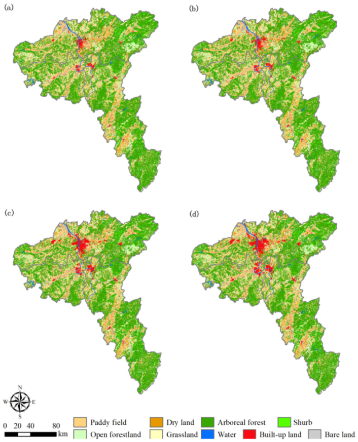
2.2.1. Data

The climate data for 2000–2015 were obtained from the National Tibetan Plateau Third Pole Environment Data Center (TPDC) [28]. They include monthly mean temperature, monthly mean precipitation, and monthly mean solar radiation. Land-use maps of the study area, derived from Landsat TM/ETM+/OLI imageries in 2000, 2005, 2010, and 2015, were obtained from the Resource and Environment Science and Data Center (https://www.resdc.cn/, accessed on 07 November 2021). The land use is divided into nine classes: paddy field, dry land, arboreal forest, shrub, open forest land, grassland, water, built-up land, and bare land (see Table 1) (Figure 1). Moreover, monthly NDVI values were obtained using the maximum-value compositing algorithm based on time-series MODIS NDVI images at the pixel level.

2.2.2. Scenarios

In this study, we calculated the total production (TP) in an area based on Equation (1):
TP = NPP × Area
To decouple and analyze the effects of climate changes (i.e., temperature, precipitation, and solar radiation) and land-use changes (i.e., afforestation, urbanization, and others) on the total production in CZT, we designed six scenarios to estimate the potential TP in 2000 and 2015 (see Table S1) [9].
In this study, we kept the climate conditions (i.e., precipitation, temperature, and solar radiation) at the 2000 level in scenario A, and then we calculated the potential TP in 2000, indicated as TP2000. We also estimated TPA based on the land-use map and NDVI images from 2015. The effects of land-use change (ΔLUCC) could be calculated using Equation (2):
Δ LUCC = TP A TP 2000
The overall effects on TP (ΔALL) were calculated based on the difference between the actual TP of 2000 and 2015 (see Equation (3)):
Δ ALL = TP 2015 TP 2000
Based on the above information, we calculated the effects of climate changes (ΔClimate) using Equation (4):
Δ Climate = Δ ALL Δ LUCC
To decouple the effects of different climate conditions, we designed three different scenarios: keeping the precipitation at the 2000 level with no change (scenario B), keeping the temperature at the 2000 level with no change (scenario C), and keeping the solar radiation at the 2000 level with no change (scenario D). Based on these scenarios, we estimated the effects of precipitation (ΔPrecipitation), temperature (ΔTemperature), and solar radiation (ΔRadiation) on TP, respectively (Table S1) [9].
To decouple the effects of different land-use changes, we used Equation (5) as follows:
Δ LUCC = Δ Afforestation + Δ Urbanization + Δ Others
where ΔAfforestation represents the effects of afforestation on TP, estimated based on scenario E (Table S1); ΔUrbanization represents the effects of urbanization on TP, estimated based on scenario F (Table S1); and ΔOthers represents the effects of other land-use changes.

2.3. Modeling

2.3.1. CASA Model

The CASA model is based on process development and is driven by light-use efficiency [29]. It was used to estimate the NPP from absorbed photosynthetic active solar radiation (APAR) and light-use efficiency (ε) [17]. APAR was estimated using Equation (6):
APAR ( x ,   t ) = SOL ( x ,   t ) × FPAR ( x ,   t ) × 0.5
where SOL is the total solar radiation; FPAR is the fraction of the photosynthetically active solar radiation absorbed by vegetation canopy; t is time; x is the spatial location. The constant 0.5 indicates the proportion of effective solar radiation available to vegetation from the total solar radiation [30]. In this study, FPAR was calculated using Equation (7):
FPAR ( x , t ) = FPAR ( x , t ) NDVI + FPAR ( x , t ) SR 2
where FPAR(x, t)NDVI is the FPAR calculated by NDVI in pixel x and month t (see Equation (8)); SR is the simple ratio of NDVI and is calculated by NDVI(x, t) (see Equation (9)); FPAR(x, t)SR is the FPAR calculated by SR in pixel x and month t (see Equation (10)) [31].
FPAR ( x , t ) NDVI = ( NDVI ( x , t ) NDVI i , min ) ( FPAR max FPAR min ) ( NDVI i , max NDVI i , min ) + FPAR min
SR ( x , t ) = 1 + NDVI ( x , t ) 1 NDVI ( x , t )
FPAR ( x , t ) SR = ( SR ( x , t ) SR i , min ) ( FPAR max FPAR min ) SR i , max SR i , min + FPAR min
where FPARmax and FPARmin are 0.950 and 0.001, respectively, in this study; NDVIi,min is the minimum value of the NDVI for the land-use type i in month t; NDVIi,max is the maximum value of the NDVI for the land-use type i in month t; SRi,min is the minimum SR value for the land-use type i in month t; SRi,max is the maximum SR value for the land-use type i in month t; and NDVI(x, t) is the NDVI in pixel x and month t [30].
Light-use efficiency (ε), which is the efficiency of vegetation to convert absorbed photosynthetic effective solar radiation into organic carbon, is a key parameter for calculating NPP [20]. It can be affected by various environmental conditions (e.g., temperature and moisture). In the CASA model, ε is estimated using Equation (11):
ε ( x , t ) = T ε 1 ( x , t ) × T ε 2 ( x , t ) × W ε ( x , t ) × ε max
where Tɛ1(x, t) and Tɛ2(x, t) are temperature stress coefficients, which indicate the reduction in light-use efficiency caused by temperature; Wɛ(x, t) is the moisture stress coefficient, which reflects the reduction in light-use efficiency caused by moisture; and εmax is the maximum light-use efficiency and is determined by the empirical method [20]. For details of the above parameters, see Table S2.

2.3.2. Coefficient of Variation

In this study, the stability of the interannual variation of the NDVI in the CZT urban agglomeration is represented as the coefficient of variation (Cv) from 2000 to 2015. Cv is a useful indicator for analyzing the interannual variability of an ecosystem. It is a statistical index, which means the ratio of a variable relative to its average, and is estimated using Equation (12):
C v = 1 N D V I 1 n 1 i = 1 n ( N D V I i N D V I ¯ ) 2
To illuminate and analyze the spatial dynamics of the NPP in CZT, we evaluated the mean annual NPP and its linear trend between 2000 and 2015. According to the linear trends of annual NPP and their significance, we defined three NPP change types (i.e., no change, increase, and decrease).

3. Results

3.1. Changes in NPP

Based on the simulated results from the CASA model, the annual NPP in the whole area of the CZT urban agglomeration was 587.42 ± 106.68 gC•m−2 in 2000, and reached a peak value (i.e., 702.00 ± 232.60 gC•m−2) in 2014. After that, the annual NPP decreased to 657.41 ± 206.66 gC•m−2 in 2015 (Figure 2a). The lowest NPP value was 514.01 ± 121.43 gC•m−2 in 2005. The average annual NPP was 628.99 ± 150.86 gC•m−2•yr−1 in the study area from 2000 to 2015. We found that there was an increasing trend (i.e., 7.31 gC•m−2•yr−1) for annual NPP in the whole area of CZT during the period 2000–2015 (Figure 2a). The different cities all had an upward trend for annual NPP between 2000 and 2015. The increasing trend of annual NPP was 9.70 (Figure 2b), 5.22 (Figure 2c), and 6.87 gC•m−2•yr−1 (Figure 2d) in Zhuzhou, Changsha, and Xiangtan from 2000 to 2015, respectively. The maximum value of NPP occurred in Zhuzhou in 2014, with an annual NPP of 780.45 ± 231.55 gC•m−2. Meanwhile, the minimum value of NPP was 479.71 ± 83.66 gC•m−2 and occurred in Xiangtan in 2005. Between 2000 and 2015, the NPP increased by 7.53%, 10.08%, and 17.16% in Changsha, Xiangtan, and Zhuzhou, respectively.
Our simulations demonstrated that the mean annual NPP presented a distinct heterogeneity in the study areas (Figure 3a). The areas with a very low annual NPP were mainly distributed in the middle of the north region, which also comprises the core built-up area of the three cities (Figure 3a). The maximum increasing rate was 36.52 gC•m−2•yr−1 in the middle of the east of the study areas, while the maximum decreasing rate was −24.33 gC•m−2•yr−1 in the north-central part of the study areas (Figure 3b). We also found that the mean annual NPP indicated a decreasing trend around the built-up areas during 2000–2015. In addition, the mean annual NPP changed significantly in the central region and the middle of the east region in the study area, as we found that the p-values of the t-test for the modeled slope of these pixels were less than 0.05 in these regions (Figure 3c).
The simulated results show that the annual NPP had an increasing trend in 37.51% of the study area and a decreasing trend in 11.43% of the study area (Figure 3d). The decrease areas (i.e., the red color in Figure 3d) were mainly distributed in the middle of the north region. Meanwhile, the increase areas (i.e., the green color in Figure 3d) were mainly distributed in the middle of the east region.

3.2. The Effects of Climate Changes on Total Production

In the study area, temperature, precipitation, and solar radiation indicated different linear change rates of 0.035 °C•yr−1, −0.241 mm•yr−1, and 3.886 MJ•m−2•yr−1, respectively, from 2000 to 2015. Figure 4 shows that the spatial distribution characteristics of them are quite different. The temperature had an increasing trend in most regions, except the southern region of CZT (Figure 4a). The increased precipitation was mainly concentrated in the northeast, while the southern area had decreased precipitation (Figure 4b). For solar radiation, the northeast of the study area showed a decreasing trend, but the western and southern regions showed an increasing trend from 2000 to 2015 (Figure 4c). Based on the scatters and fitted linear correlations analysis, we found that the annual NPP positively correlated with temperature (Figure 5a) and solar radiation (Figure 5c) but negatively correlated with precipitation (Figure 5b). The correlation coefficient between NPP and temperature was lower in the north central part of the study area, but a higher correlation coefficient was sparsely distributed in the central parts of the CZT area (Figure 6a). For precipitation, higher correlation coefficients were distributed in the northeast region (Figure 6b). However, the opposite distribution could be observed for the correlation coefficient between NPP and solar radiation in the study area (Figure 6c).
Based on our results, we found that the effect of climate changes on the total production was −1.44 T gC in the whole area of the CZT urban agglomeration between 2000 and 2015 (Table 2). Our scenario simulations showed that Changsha, Zhuzhou, and Xiangtan faced negative effects of climate changes on the total production by −0.50, −0.72, and −0.22 T gC from 2000 to 2015, respectively. We also found that precipitation was the main meteorological driving factor influencing the NPP of the CZT areas, followed by solar radiation and temperature (Table 3). Solar radiation had a positive effect on the total production by 1.59 T gC, but precipitation and temperature had negative effects on the total production by −1.62 and −1.41 T gC, respectively, during the period 2000–2015 (Table 2). In the same period, we found that the total production of Zhuzhou was the most affected by temperature (i.e., −0.73 T gC), precipitation (i.e., −0.76 T gC), and solar radiation (i.e., 0.77 T gC) (Table 2).

3.3. The Effects of Land-Use Changes on Total Production

Our simulations indicated that the effect of land-use changes on the total production was 3.42 T gC in the whole area of the CZT urban agglomeration between 2000 and 2015 (Table 3). We found that the afforestation area was 163.72 km2 in the study areas between 2000 and 2015, and it had a positive effect on the total production by 0.05 T gC (Table 3). At the same time, the area of built-up land increased from 650.34 to 1387.83 km2 in CZT (Table 1). The simulated results show that the negative effect of urbanization (i.e., −0.05 T gC) was almost equal to the positive effect of urbanization on the total production in CZT during the period 2000–2015. In fact, urbanization also had slight effects on the total production for each city in the CZT region from 2000 to 2015. The effects of urbanization on the total production were −0.03 T gC in Changsha, −0.01 T gC in Xiangtan, and −0.01 T gC in Zhuzhou (Table 3).

4. Discussion

4.1. Validation

As it is very difficult to monitor NPP in a large area, it is often difficult to verify the accuracy of simulation results on a large scale [10,32]. Here, we compare and verify our simulation results with relevant studies. Zhang and Zeng [33] reported that the annual NPP was 260.88–323.01 gC•m−2•yr−1 in the core urban areas of the CZT urban agglomeration in 2015, and our results on the annual NPP in the same region were basically consistent. The annual NPP of the core urban areas was 250.33–301.22 gC•m−2•yr−1 in this study in 2015. Although uncertainties caused by the different spatiotemporal scales and land-use type changes in different regions always exist, other previous studies demonstrated that the NPP estimated by the CASA model combined with MODIS datasets was reliable in China [10,18,34].

4.2. Response of Carbon Dynamics to Climate Changes

Climatic conditions have different effects on the NPP of terrestrial ecosystems of different regions [35,36]. In this study, climate changes had a negative effect on the total production of the CZT area from 2000 to 2015. Our investigation demonstrated that this negative effect mainly came from the increasing trend of temperature (0.035 °C•yr−1) and the decreasing trend of precipitation (−0.241 mm•yr−1) in the study areas. Lauerwald et al. [37] pointed out that the NPP of a forest ecosystem could decrease with an increase in temperature if there is enough precipitation in the region, and, as mentioned earlier, the CZT urban agglomeration is located in a humid area with a subtropical monsoon climate. Although precipitation showed a decreasing trend from 2000 to 2015, the average annual precipitation was still more than 1500 mm•yr−1. Another reason might be the increase in soil respiration (i.e., autotrophic and heterotrophic soil respiration) caused by the increase in temperature, which leads to carbon losses [38].
The mechanism behind the effect of climate factors on regional carbon dynamics is complicated [10]. In this study, although the effect of precipitation on total production was greater than that of both temperature and solar radiation, there was little difference between them. Our results are similar to those of Nemani et al. [39], who reported that about 40% of vegetation growth is mainly limited by water resources, while 33% and 27% is limited by temperature and solar radiation, respectively.

4.3. Response of Carbon Dynamics to Land-Use Changes

Land-use change is one of the most important human disturbances to regional carbon dynamics [40]. Our observation indicates that urban expansions and ecological land losses (i.e., cropland, forest land, and grassland) had a highly similar spatial distribution in the CZT areas (Figure 1). We found that land-use change in CZT was driven by urbanization expansion and the influence of ecological protection from 2000 to 2015. In this process, the increased built-up land (i.e., 737.49 km2) mainly came from cropland (i.e., 399.02 km2) and forest land (i.e., 351.79 km2) from 2000 to 2015 (Table 4). This result is consistent with that of Zhu and He [4]. All these caused a reduction in productivity (i.e., −0.05 T gC) in the CZT areas between 2000 and 2015.
Moreover, because ΔOthers was 3.42 T gC in our study areas from 2000 to 2015, the effects of other land-use changes played a key positive role in carbon sequestration in the study areas. The cities most and least affected by ΔOthers were Zhuzhou (i.e., 1.87 T gC) and Xiangtan (i.e., 0.51 T gC), respectively (Table 3). We think that the main source of ΔOthers is the natural growth brought on by the protection of original vegetation. The natural growth of original forest land has been the main driver of the increasing trend of NPP in the CZT areas in the past decade. During this period, the afforested area was 163.72 km2, while 489.89 km2 of forest land was converted to other land types. However, the majority of forest land (i.e., 17,452.78 km2) was protected, with no land-use change. From the spatial distribution map of NPP change (Figure 3d) and the spatially explicit land-use maps (Figure 1), we also found that the areas with increased NPP were highly coincident with well-protected forest areas (such as urban green core regions, forest parks, etc.). These areas may benefit from the impact of the recent ecological restoration project, the “overall planning of ecological core green area of CZT urban agglomeration” [22]. In addition, our observation showed that about 37.51% of the study area had an increasing trend of annual NPP from 2000 to 2015 (Figure 3d), while 51.06% of the study area had no change trend for annual NPP (Figure 3d). These results demonstrate that the overall status of land vegetation in CZT became better during the period 2000–2015.

4.4. Limitation and Future Work

Some uncertainties in this study must also be considered. The first uncertainty comes from the downscaling of MODIS NDVI products, because the NPP simulated by the CASA model needs more precise NDVI data to improve the simulation accuracy [41]. Secondly, the input of climate data, which involved a fusion of remote sensing products, reanalysis datasets, and in situ observation data from weather stations, might bring uncertainty to the data accuracy [28]. Thirdly, we did not consider the uncertainty from natural disturbances (e.g., fire, insects, and wind). Ignoring these natural disturbances may lead to overestimation of the NPP at the regional scale [42,43]. In addition, some previous studies indicated that the increase in atmospheric carbon dioxide concentration and the acceleration of nitrogen deposition may affect the simulation of regional NPP [34,44,45,46]. Overall, the impacts of the above shortcomings on the estimation of NPP certainly need to be further considered and addressed in future work.

5. Conclusions

In this study, the CASA model was used to estimate the annual NPP in the CZT urban agglomeration from 2000 to 2015. Although urbanization has obviously occurred in the past sixteen years, the annual NPP in this region has maintained an upward trend. Zhuzhou had the highest increasing trend of NPP at 9.70 gC•m−2•yr−1 from 2000 to 2015. The maximum annual NPP (i.e., 780.45 gC•m−2) occurred in Zhuzhou in 2014. Meanwhile, we found that the mean annual NPP presented distinct heterogeneity in the study areas. The mean annual NPP was lower in the middle of the north region than elsewhere, which indicated a decreasing trend around the built-up areas.
Moreover, this study revealed the effects of climate changes and land-use changes on the carbon sequestration capacity in CZT between 2000 and 2015. According to our scenario simulations, land-use changes had a positive effect on the total production of the CZT area of 3.42 T gC—greater than the negative effects from climate changes of −1.44 T gC during the period 2000–2015. We found that both temperature and precipitation had significantly negative effects on the total production in the study areas. Contrarily, solar radiation had a positive effect on the total production in the same period. Our results also showed that the positive effect of afforestation offset the negative effect of urbanization in CZT from 2000 to 2015. As the proportion of forest land in the region remained relatively high (i.e., >62.60%), the negative effect on carbon sequestration of vegetation caused by urbanization and climate changes could be ignored in the CZT urban agglomeration from 2000 to 2015. Our study suggests that protecting existing forests and vegetation is the most effective way to increase regional carbon sink.

Supplementary Materials

The following are available online at https://www.mdpi.com/article/10.3390/f12111573/s1, Table S1: The information of six different scenarios in the “Chang–Zhu–Tan” urban agglomeration from 2000 to 2015; Table S2: Parameters of the CASA model for different land-use types in the CZT urban agglomeration.

Author Contributions

Conceptualization, C.L. and Z.L.; methodology, C.L.; software, Z.L.; validation, K.Z.; formal analysis, Y.L.; writing—original draft preparation, C.L.; writing—review and editing, Z.L. and B.X.; visualization, C.L. and B.X.; supervision, B.X.; project administration, B.X.; funding acquisition, B.X. and X.L. All authors have read and agreed to the published version of the manuscript.

Funding

This study was supported by the Natural Science Foundation of Hunan Province, China (grant no. 2021JJ40338), the Projects of Hunan Provincial Natural Resources Research Science Fund (2021-42), and the outstanding Youth Project of the Hunan Provincial Education Department (19B350).

Institutional Review Board Statement

Not applicable.

Informed Consent Statement

Not applicable.

Acknowledgments

The authors would like to thank the anonymous reviewers for their constructive comments on improving this paper.

Conflicts of Interest

The authors declare no conflict of interest.

References

  1. Crabtree, R.; Potter, C.; Mullen, R.; Sheldon, J.; Huang, S.L.; Harmsen, J.; Rodman, A.; Jean, C.A. Modeling and spatio-temporal analysis framework for monitoring environmental change using NPP as an ecosystem indicator. Remote Sens. Environ. 2009, 113, 1486–1496. [Google Scholar] [CrossRef] [Green Version]
  2. Gingrich, S.; Niedertscheider, M.; Kastner, T.; Haberl, H.; Cosor, G.; Krausmann, F.; Kuemmerle, T.; Müller, D.; Reith-Musel, A.; Jepsen, M.R.; et al. Exploring long-term trends in land use change and aboveground human appropriation of net primary production in nine European countries. Land Use Policy 2015, 47, 426–438. [Google Scholar] [CrossRef]
  3. Yang, Y.T.; Qu, S.; Cai, B.F.; Liang, S.; Xu, M. Mapping global carbon footprint in China. Nat. Commun. 2020, 11, 2237. [Google Scholar] [CrossRef] [PubMed]
  4. Zhu, Z.; He, Q.Y. Spatio-temporal evaluation of the urban agglomeration expansion in the middle reaches of the Yangtze River and its impact on ecological lands. Sci. Total Environ. 2021, 790, 148150. [Google Scholar]
  5. Huang, C.; Huang, X.; Peng, C.; Zhou, Z.; Teng, M.; Wang, P. Land use/cover change in the Three Gorges Reservoir area, China: Reconciling the land use conflicts between development and protection. Catena 2019, 175, 388–399. [Google Scholar] [CrossRef]
  6. Morel, A.C.; Adu Sasu, M.; Adu-Bredu, S.; Quaye, M.; Moore, C.; Ashley Asare, R.; Mason, J.; Hirons, M.; McDermott, C.L.; Robinson, E.J.Z.; et al. Carbon dynamics, net primary productivity (NPP) and human appropriated NPP (HANPP) across a forest-cocoa farm landscape in West Africa. Glob. Chang. Biol. 2019, 25, 2661–2677. [Google Scholar] [CrossRef]
  7. Bondeau, A.; Kicklighter, D.W.; Kaduk, J.; ThE. Participants OF. ThE. Potsdam NpP. Model Intercomparison. Comparing global models of terrestrial net primary productivity (NPP): Importance of vegetation structure on seasonal NPP estimates. Glob. Chang. Biol. 1999, 5, 35–45. [Google Scholar] [CrossRef]
  8. Liu, Z.; Peng, C.; De Grandpré, L.; Candau, J.N.; Work, T.; Huang, C.; Kneeshaw, D. Simulation and analysis of the effect of a spruce budworm outbreak on carbon dynamics in boreal forests of Québec. Ecosystems 2019, 22, 1838–1851. [Google Scholar] [CrossRef]
  9. Liao, Q.; Wang, Z.; Huang, C. Green infrastructure offset of the negative ecological effects of urbanization and storing water in the three gorges reservoir area, china. Int. J. Environ. Res. Public Health 2020, 17, 8077. [Google Scholar] [CrossRef] [PubMed]
  10. Liu, F.H.; Xu, C.Y.; Yang, X.X.; Ye, X.C. Controls of Climate and Land-Use Change on Terrestrial Net Primary Productivity Variation in a Subtropical Humid Basin. Remote Sens. 2020, 12, 3525. [Google Scholar] [CrossRef]
  11. Chen, S.; Chen, B.; Fath, B.D. Urban ecosystem modeling and global change: Potential for rational urban management and emissions mitigation. Environ. Pollut. 2014, 190, 139–149. [Google Scholar] [CrossRef] [PubMed]
  12. Zhou, X.; Peng, C.; Dang, Q.L.; Sun, J.; Wu, H.; Hua, D. Simulating carbon exchange in Canadian Boreal forests: I. Model structure, validation, and sensitivity analysis. Ecol. Model. 2008, 219, 287–299. [Google Scholar] [CrossRef]
  13. Peng, C.H.; Liu, J.; Dang, Q.; Apps, M.J.; Jiang, H. TRIPLEX: A generic hybrid model for predicting forest growth and carbon and nitrogen dynamics. Ecol. Model. 2002, 153, 109–130. [Google Scholar] [CrossRef]
  14. Zhu, Q.; Peng, C.; Chen, H.; Fang, X.; Liu, J.; Jiang, H.; Yang, Y.; Yang, G. Estimating global natural wetland methane emissions using process modelling: Spatio-temporal patterns and contributions to atmospheric methane fluctuations. Glob. Ecol. Biogeogr. 2015, 24, 959–972. [Google Scholar] [CrossRef]
  15. Carver, A.D.; Unger, D.R.; Parks, C.L. Modeling energy savings from urban shade trees: An assessment of the CITYgreen energy conservation module. Environ. Manag. 2004, 34, 650–655. [Google Scholar] [CrossRef] [PubMed]
  16. Baines, O.; Wilkes, P.; Disney, M. Quantifying urban forest structure with open-access remote sensing data sets. Urban. For. Urban. Gree. 2020, 50, 126653. [Google Scholar] [CrossRef]
  17. Potter, C.S.; Randerson, J.T.; Field, C.B.; Matson, P.A.; Klooster, S.A. Terrestrial ecosystem production: A process model based on global satellite and surface data. Glob. Biogeochem. Cycles 1993, 7, 811–841. [Google Scholar] [CrossRef]
  18. Piao, S.L.; Fang, J.Y.; Guo, Q.H. Application of casa model to the estimation of Chinese terrestrial net primary productivity. Acta Phytoecol. Sin. 2001, 21, 603–608. (In Chinese) [Google Scholar]
  19. Wang, H.; Zhang, J.; Zhu, F.; Zhang, W. Analysis of spatial pattern of aerosol optical depth and affecting factors using spatial autocorrelation and spatial autoregressive model. Environ. Earth Sci. 2016, 75, 822. [Google Scholar]
  20. Xu, H.; Zhao, C.; Wang, X. Elevational differences in the net primary productivity response to climate constraints in a dryland mountain ecosystem of northwestern China. Land Degrad. Dev. 2020, 31, 2087–2103. [Google Scholar] [CrossRef]
  21. Zou, Z.; Wu, T.; Xiao, Y.; Song, C.; Ouyang, Z. Valuing natural capital amidst rapid urbanization: Assessing the gross ecosystem product (gep) of china’s “Chang-Zhu-Tan” megacity. Environ. Res. Lett. 2020, 15, 124019. [Google Scholar] [CrossRef]
  22. Master Plan for Ecological Green Core Area of Chang Zhu Tan Urban Agglomeration (2010–2030). Hunan Provincial Government, China. 2018. Available online: http://zrzyt.hunan.gov.cn/zrzyt/xxgk/tzgg/201909/t20190926_10466709.html (accessed on 16 September 2021). (In Chinese)
  23. Liu, C.; Xiang, W.H.; Lei, P.F.; Deng, X.W.; Tian, D.L.; Fang, X.; Peng, C.H. Standing fine root mass and production in four Chinese subtropical forests along a succession and species diversity gradient. Plant Soil 2014, 376, 445–459. [Google Scholar] [CrossRef]
  24. Ouyang, S.; Xiang, W.H.; Wang, X.P.; Xiao, W.F.; Chen, L.; Li, S.G.; Sun, H.; Deng, X.W.; Forrester, D.I.; Zeng, L.X.; et al. Effects of stand age, richness and density on productivity in subtropical forests in China. J. Ecol. 2019, 107, 2266–2277. [Google Scholar] [CrossRef]
  25. Xiang, W.H.; Fan, G.W.; Lei, P.F.; Zeng, Y.L.; Tong, J.; Fang, X.; Deng, X.W.; Peng, C.H. Fine root interactions in subtropical mixed forests in China depend on tree species composition. Plant Soil 2015, 395, 335–349. [Google Scholar] [CrossRef]
  26. IUSS Working Group WRB (2015) World Reference Base for Soil Resources 2014, update 2015. In International Soil Classification System for Naming Soils and Creating Legends for Soil Maps; World Soil Resources Reports No. 106; FAO: Rome, Italy, 2015.
  27. Ouyang, S.; Xiang, W.H.; Gou, M.M.; Chen, L.; Lei, P.F.; Xiao, W.F.; Deng, X.W.; Zeng, L.X.; Li, J.R.; Zhang, T.; et al. Stability in subtropical forests: The role of tree species diversity, stand structure, environmental and socio-economic conditions. Glob. Ecol. Biogeogr. 2021, 30, 500–513. [Google Scholar] [CrossRef]
  28. Yang, K.; He, J. China Meteorological Forcing Dataset (1979–2018); National Tibetan Plateau Data Center: Beijing, China, 2019. [Google Scholar] [CrossRef]
  29. Bao, G.; Bao, Y.; Qin, Z.; Xin, X.; Bao, Y.; Bayarsaikan, S.; Zhou, Y.; Chuntai, B. Modeling net primary productivity of terrestrial ecosystems in the semi-arid climate of the Mongolian Plateau using LSWI-based CASA ecosystem model. Int. J. Appl. Earth Obs. Geoinf. 2016, 46, 84–93. [Google Scholar] [CrossRef]
  30. Zhu, W.; Pan, Y.; He, H.; Yu, D.; Hu, H. Simulation of maximum light use efficiency for some typical vegetation types in China. Chin. Sci. Bull. 2006, 51, 457–463. [Google Scholar] [CrossRef]
  31. Yu, D.; Shi, P.; Shao, H.; Zhu, W.; Pan, Y. Modelling net primary productivity of terrestrial ecosystems in East Asia based on an improved CASA ecosystem model. Int. J. Remote Sens. 2009, 30, 4851–4866. [Google Scholar] [CrossRef]
  32. Pretzsch, H.; Forrester, D.I.; Rtzer, T. Representation of species mixing in forest growth models. A review and perspective. Ecol. Model. 2015, 313, 276–292. [Google Scholar] [CrossRef] [Green Version]
  33. Zhang, M.; Zeng, Y. Net primary production estimation by using fusion remote sensing data with high spatial and temporal resolution. J. Remote Sens. 2018, 22, 143–152. (In Chinese) [Google Scholar]
  34. Zhu, W.Q.; Pan, Y.Z.; Zhang, J.S. Estimation of net primary productivity of Chinese terrestrial vegetation based on remote sensing. J. Plant Ecol. 2007, 31, 413–424. [Google Scholar]
  35. Harris, J.A.; Hobbs, R.J.; Higgs, E.; Aronson, J. Ecological restoration and global climate change. Restor. Ecol. 2006, 14, 170–176. [Google Scholar] [CrossRef]
  36. Liu, C.; Xiang, W.H.; Xie, B.G.; Ouyang, S.; Zeng, Y.L.; Lei, P.F.; Peng, C.H. Decoupling the complementarity effect and the selection effect on the overyielding of fine root production along a tree species richness gradient in subtropical forests. Ecosystems 2020, 24, 613–627. [Google Scholar] [CrossRef]
  37. Lauerwald, R.; Hartmann, J.; Ludwig, W.; Moosdorf, N. Assessing the nonconservative fluvial fluxes of dissolved organic carbon in North America. J. Geophy. Res.-Biogeo 2012, 117, G01027. [Google Scholar] [CrossRef]
  38. Hui, D.; Qi, D.; Tian, H.; Luo, Y. Climate Change and Carbon Sequestration in Forest Ecosystems; Springer International Publishing: Cham, Switzerland, 2017; pp. 1–40. [Google Scholar]
  39. Nemani, R.R.; Keeling, C.D.; Hashimoto, H.; Jolly, W.M.; Piper, S.C.; Tucker, C.J.; Myneni, R.B.; Running, S.W. Climate-driven increases in global terrestrial net primary production from 1982 to 1999. Science 2003, 300, 1560–1563. [Google Scholar] [CrossRef] [PubMed] [Green Version]
  40. McDowell, N.G.; Sevanto, S. The mechanisms of carbon starvation: How, when, or does it even occur at all? New Phytol. 2010, 186, 264–266. [Google Scholar] [CrossRef] [PubMed]
  41. Im, J.; Park, S.; Rhee, J.; Baik, J.; Choi, M. Downscaling of amsr-e soil moisture with modis products using machine learning approaches. Environ. Earth Sci. 2016, 75, 1120. [Google Scholar] [CrossRef]
  42. Kurz, W.A.; Stinson, G.; Rampley, G.J.; Dymond, C.C.; Neilson, E.T. Risk of natural disturbances makes future contribution of Canada’s forests to the global carbon cycle highly uncertain. Proc. Natl. Acad. Sci. USA 2008, 105, 1551–1555. [Google Scholar] [CrossRef] [PubMed] [Green Version]
  43. Cooper, L.A.; Ballantyne, A.P.; Holden, Z.A.; Landguth, E.L. Disturbance impacts on land surface temperature and gross primary productivity in the western United States. J. Geophys. Res.-Biogeo. 2017, 122, 930–946. [Google Scholar] [CrossRef]
  44. Yu, L.; Dong, T.F.; Lu, Y.B.; Song, M.Y.; Duan, B.L. Ecophysiological responses of cunninghamia lanceolata to nongrowing-season warming, nitrogen deposition, and their combination. Photosynthetica 2016, 54, 598–610. [Google Scholar] [CrossRef]
  45. Yue, K.; Fornara, D.A.; Yang, W.; Peng, Y.; Peng, C.; Liu, Z.; Wu, F.; Niu, S. Influence of multiple global change drivers on terrestrial carbon storage: Additive effects are common. Ecol. Lett. 2017, 20, 663. [Google Scholar] [CrossRef] [PubMed]
  46. Reich, P.B.; Hobbie, S.E.; Lee, T.D.; Rich, R.; Worm, K. Synergistic effects of four climate change drivers on terrestrial carbon cycling. Nat. Geosci. 2020, 13, 1–7. [Google Scholar] [CrossRef]
Figure 1. Spatially explicit land-use maps of the CZT urban agglomeration in (a) 2000, (b) 2005, (c) 2010, and (d) 2015.
Forests 12 01573 g001
Figure 2. Temporal variation in annual NPP (gC•m−2) in the CZT urban agglomeration from 2000 to 2015. (a) The total values for CZT; (b) the values for Zhuzhou; (c) the values for Changsha; (d) the values for Xiangtan. Note: The red line indicates the linear fitting during the period from 2000 to 2015. The p-value documents the significance. Error bars extending from the means document the standard deviation of annual NPP, while the light red region is the 95% confidence intervals of the linear model.
Forests 12 01573 g002
Figure 3. Spatiotemporal variations in annual NPP (gC•m−2) in the CZT urban agglomeration at the pixel level between 2000 and 2015. (a) Average annual NPP; (b) change trends of annual NPP (gC•m−2); (c) p-value of the t-test for the modeled slopes; (d) the NPP change types. Note: The least-square linear regression model was applied to analyze the temporal variation in annual NPP between 2000 and 2015 for each pixel. The changing trend is described by the modeled slope in (b). In (d), “No change” documents that the annual NPP did not change (a = 0 and p ≤ 0.05) or did change, but not significantly (a ≠ 0 and p > 0.05).
Forests 12 01573 g003
Figure 4. Spatial variation of climate variables in the CZT urban agglomeration from 2000 to 2015. (a) Temperature (°C), (b) precipitation (mm), and (c) radiation (MJ•m−2).
Forests 12 01573 g004
Figure 5. Scatters and fitted linear correlations between annual NPP and (a) temperature, (b) precipitation, and (c) radiation in the CZT urban agglomeration.
Forests 12 01573 g005
Figure 6. Spearman’s rank correlations between the annual NPP and climate variables in the CZT urban agglomeration from 2000 to 2015. (a) NPP–temperature; (b) NPP–precipitation; (c) NPP–radiation.
Forests 12 01573 g006
Table 1. The classification, description, and area of the nine different land-use types in this study.
Class IClass IIDescriptionArea (km2)
20002015
Crop landPaddy fieldCultivated land with guaranteed water source and irrigation facilities, which can be irrigated normally in general years to plant aquatic crops such as rice and lotus root. Also includes cultivated land with rice and dry land crop rotation.7409.457061.96
Dry landIncludes cultivated land that grows crops by natural precipitation; dry crop cultivated land with water source and irrigation facilities that can be irrigated normally in general years; and cultivated land mainly for growing vegetables, with normal rotation of fallow land and rest land.1153.531061.84
Forest landArboreal forestNatural and plantation forests with canopy density >40%. Includes timber forest, economic forest, shelter forest, and other woodlands.13,408.6812,902.20
ShrubLow and shrub woodland with canopy density >40% and height below 2 m.669.49669.18
Open forest landForest with canopy density <40%3864.504045.17
Grassland Includes natural, improved, and mowed grasslands with dense growth. 444.23436.21
Water Natural waters and water conservancy facilities.517.38547.56
Built-up land Urban and rural residential land, mining land, and other transportation land outside urban and rural areas.650.341387.83
Bare land Land with surface soil coverage and vegetation coverage <5%.4.099.88
Table 2. The effects of climate changes, precipitation, temperature, and radiation on the total production (T gC) in the CZT urban agglomeration from 2000 to 2015. ΔClimate, the effect of climate changes; ΔPrecipitation, the effect of precipitation changes; ΔTemperature, the effect of temperature changes; ΔRadiation, the effect of radiation changes.
CityΔClimateΔPrecipitationΔTemperatureΔRadiation
Changsha−0.50−0.57−0.490.56
Xiangtan−0.22−0.29−0.190.26
Zhuzhou−0.72−0.76−0.730.77
Total−1.44−1.62−1.411.59
Table 3. The effects of land-use changes on the total production (T gC) in the CZT urban agglomeration from 2000 to 2015. ΔLUCC, the effect of all land-use changes; ΔAfforestation, the effect of nonforest land changes to forest land; ΔUrbanization, the effect of nonconstruction land changes to construction land; ΔOthers, the effect of other land-use changes.
CityΔLULCΔAfforestationΔUrbanizationΔOthers
Changsha1.020.01−0.031.04
Xiangtan0.510.01−0.010.51
Zhuzhou1.890.03−0.011.87
Total3.420.05−0.053.42
Table 4. Transfer matrix of land-use changes in the CZT urban agglomeration from 2000 to 2015 (unit: km2).
Land-Use TypeCroplandForest LandGrasslandWaterBuilt-Up LandBare Land
Cropland7981.98126.443.5751.33399.020.64
Forest land101.8117,452.788.0921.70351.796.50
Grassland1.6815.32422.880.703.650.00
Water18.528.980.44470.0019.210.23
Built-up land19.7212.950.123.37614.170.00
Bare land0.010.031.100.440.002.50
Publisher’s Note: MDPI stays neutral with regard to jurisdictional claims in published maps and institutional affiliations.

