
Forest Roads and Operational Wildfire Response Planning


Abstract
:1. Introduction
2. Wildfire Response Planning on the Arapaho-Roosevelt National Forest, Colorado, USA
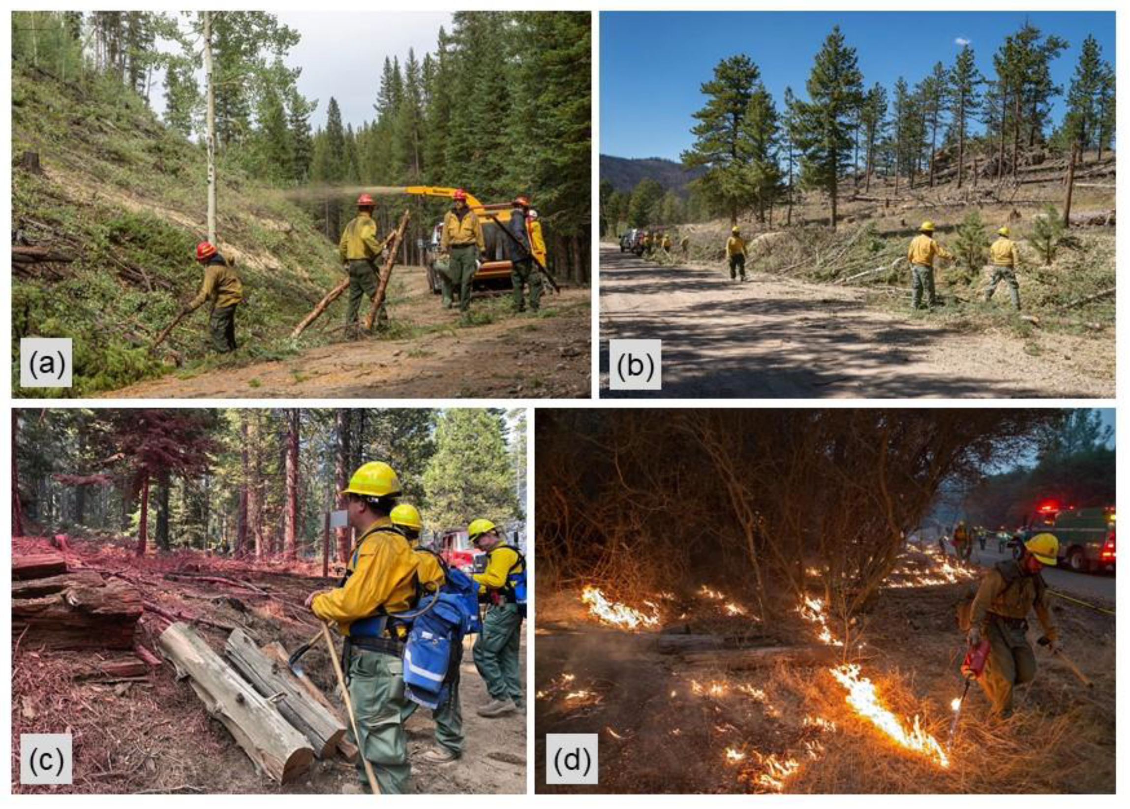
3. Wildfire Response on the Arapaho-Roosevelt National Forest: Cameron Peak Fire
4. Discussion
5. Conclusions
Author Contributions
Funding
Institutional Review Board Statement
Informed Consent Statement
Data Availability Statement
Acknowledgments
Conflicts of Interest
Disclaimer
Appendix A


| Layer | Description | Data Sources |
|---|---|---|
| roaddist | Euclidean distance (m) from major roads defined as speed categories 1–5 (highest speeds). | NAVTEQ/HERE road polylines (here.com) |
| barrierdist | Euclidean distance (m) from waterbodies and large patches of non-burnable cover. Waterbodies include perennial streams, rivers, lakes, reservoirs, swamps, and marshes. Large patches of non-burnable cover were defined as contiguous areas of non-burnable fuels ≥ 1.8 ha. | National hydrography dataset (usgs.gov/core-science-systems/ngp/national-hydrography), LANDFIRE fuels (landfire.gov) |
| costdist | Least cost distance (unitless) from major roads accounting for firefighter travel resistance factors like O’Connor et al. (2017). Resistance factors (in parentheses) account for minor roads (2), trails (4), no roads or trails (10), increasing travel difficulty with slope (1–16), and increasing travel difficulty with waterbody width and depth (5–30). Resistance factors are summed except for minor roads and trails. | NAVTEQ/HERE road polylines (here.com), USFS trail polylines (https://data.fs.usda.gov/geodata/), National hydrography dataset (usgs.gov/core-science-systems/ngp/national-hydrography), LANDFIRE topography (landfire.gov) |
| RTC | Resistance to control was calculated by fire behavior fuel model using the inverse of fireline production rates from Dillon et al. (2015) converted first to m h−1. | LANDFIRE fuels (landfire.gov) |
| flatdist | Euclidean distance (m) from flat topography defined as topographic position index (TPI) (Weiss 2001) between −12 and 12, and slope ≤ 6 deg. | LANDFIRE topography (landfire.gov) |
| valleydist | Euclidean distance (m) from valleys defined as TPI < −12. | LANDFIRE topography (landfire.gov) |
| ridgedist | Euclidean distance (m) from ridges defined as TPI > 12. | LANDFIRE topography (landfire.gov) |
| steepdist | Euclidean distance (m) from steep topography defined as TPI between −12 and 12, and slope > 6 deg. | LANDFIRE topography (landfire.gov) |
| SDI | Relative measure of ground resource suppression difficulty index (SDI) from Rodríguez y Silva et al. (2014). SDI is calculated by dividing an energy behavior index based on flame length and heat per unit area by the sum of indices for accessibility, penetrability, mobility, and fireline construction ease. The fire behavior inputs were modeled using FlamMap 5.0 (Finney et al. 2015) for historical fire season 3rd percentile fuel moisture and 97th percentile wind speeds. | NAVTEQ/HERE road polylines (here.com), USFS trail polylines (https://data.fs.usda.gov/geodata/), LANDFIRE fuels and topography (landfire.gov), RAWS (raws.nifc.gov) |
| ROS | Fire rate of spread (ROS) (chains h−1) was modeled using FlamMap 5.0 (Finney et al. 2015) for historical fire season 3rd percentile fuel moisture and 97th percentile wind speeds. | LANDFIRE (landfire.gov), RAWS (raws.nifc.gov) |
References
- Ascoli, D.; Russo, L.; Giannino, F.; Siettos, C.; Moreira, F. Firebreak and Fuelbreak. In Encyclopedia of Wildfires and Wildland-Urban Interface (WUI) Fires; Manzello, S., Ed.; Springer: Cham, Germany, 2018. [Google Scholar] [CrossRef]
- Hegg, B. Burn Out and Backfire/Backfiring. In Encyclopedia of Wildfires and Wildland-Urban Interface (WUI) Fires; Manzello, S., Ed.; Springer: Cham, Germany, 2020. [Google Scholar] [CrossRef]
- Narayanaraj, G.; Wimberly, M.C. Influences of forest roads on the spatial pattern of wildfire boundaries. Int. J. Wildland Fire 2011, 20, 792–803. [Google Scholar] [CrossRef]
- Narayanaraj, G.; Wimberly, M.C. Influences of forest roads on the spatial patterns of human-and lightning-caused wildfire ignitions. Appl. Geogr. 2012, 32, 878–888. [Google Scholar] [CrossRef]
- Yocom, L.L.; Jenness, J.; Fulé, P.Z.; Thode, A.E. Previous fires and roads limit wildfire growth in Arizona and New Mexico, USA. For. Ecol. Manag. 2019, 449, 117440. [Google Scholar] [CrossRef]
- Katuwal, H.; Calkin, D.E.; Hand, M.S. Production and efficiency of large wildland fire suppression effort: A stochastic frontier analysis. J. Environ. Manag. 2016, 166, 227–236. [Google Scholar] [CrossRef] [PubMed]
- Simpson, H.; Bradstock, R.; Price, O. A temporal framework of large wildfire suppression in practice, a qualitative descriptive study. Forests 2019, 10, 884. [Google Scholar] [CrossRef] [Green Version]
- Sakellariou, S.; Samara, F.; Tampekis, S.; Sfougaris, A.; Christopoulou, O. Development of a Spatial Decision Support System (SDSS) for the active forest-urban fires management through location planning of mobile fire units. Environ. Hazards 2020, 19, 131–151. [Google Scholar] [CrossRef]
- Akay, A.E.; Wing, M.G.; Sivrikaya, F.; Sakar, D. A GIS-based decision support system for determining the shortest and safest route to forest fires: A case study in Mediterranean Region of Turkey. Environ. Monit. Assess. 2012, 184, 1391–1407. [Google Scholar] [CrossRef]
- Akay, A.E.; Wing, M.G.; Zengin, M.; Kose, O. Determination of fire-access zones along road networks in fire-sensitive forests. J. For. Res. 2017, 28, 557–564. [Google Scholar] [CrossRef]
- Laschi, A.; Foderi, C.; Fabiano, F.; Neri, F.; Cambi, M.; Mariotti, B.; Marchi, E. Forest road planning, construction and maintenance to improve forest fire fighting: A review. Croat. J. For. Eng. 2019, 40, 207–219. [Google Scholar]
- Mostafa, M.; Shataee Jouibary, S.; Lotfalian, M.; Sadoddin, A. Watershed road network analysis with an emphasis on fire fighting management. J. Environ. Eng. Landsc. Manag. 2017, 25, 342–353. [Google Scholar] [CrossRef]
- Stefanović, B.; Stojnić, D.; Danilović, M. Multi-criteria forest road network planning in fire-prone environment: A case study in Serbia. J. Environ. Plan. Manag. 2016, 59, 911–926. [Google Scholar] [CrossRef]
- Demir, M.; Kucukosmanoglu, A.; Hasdemir, M.; Acar, H.; Ozturk, T. Assessment of forest roads and firebreaks in Turkey. Afr. J. Biotechnol. 2009, 8, 4553–4561. [Google Scholar]
- Syphard, A.D.; Keeley, J.E.; Brennan, T.J. Factors affecting fuel break effectiveness in the control of large fires on the Los Padres National Forest, California. Int. J. Wildland Fire 2011, 20, 764–775. [Google Scholar] [CrossRef]
- Mees, R.; Strauss, D.; Chase, R. Modeling wildland fire containment with uncertain flame length and fireline width. Int. J. Wildland Fire 1993, 3, 179–185. [Google Scholar] [CrossRef]
- Wilson, A.A. Width of firebreak that is necessary to stop grass fires: Some field experiments. Can. J. For. Res. 1988, 18, 682–687. [Google Scholar] [CrossRef]
- Plucinski, M.P. Contain and control: Wildfire suppression effectiveness at incidents and across landscapes. Curr. For. Rep. 2019, 5, 20–40. [Google Scholar] [CrossRef]
- Gannon, B.M.; Thompson, M.P.; Deming, K.Z.; Bayham, J.; Wei, Y.; O’Connor, C.D. A geospatial framework to assess fireline effectiveness for large wildfires in the western USA. Fire 2020, 3, 43. [Google Scholar] [CrossRef]
- Thompson, M.P.; Lauer, C.J.; Calkin, D.E.; Rieck, J.D.; Stonesifer, C.S.; Hand, M.S. Wildfire response performance measurement: Current and future directions. Fire 2018, 1, 21. [Google Scholar] [CrossRef] [Green Version]
- Available online: https://inciweb.nwcg.gov/ (accessed on 6 December 2020).
- Dunn, C.J.; Thompson, M.P.; Calkin, D.E. A framework for developing safe and effective large-fire response in a new fire management paradigm. For. Ecol. Manag. 2017, 404, 184–196. [Google Scholar] [CrossRef]
- Dunn, C.J.; O’Connor, C.; Abrams, J.; Thompson, M.P.; Calkin, D.E.; Johnston, J.D.; Stratton, R.; Gilbertson-Day, J. Wildfire risk science facilitates adaptation of fire-prone social-ecological systems to the new fire reality. Environ. Res. Lett. 2020, 15, 25001. [Google Scholar] [CrossRef]
- Gannon, B.M.; Wei, Y.; Thompson, M.P. Mitigating source water risks with improved wildfire containment. Fire 2020, 3, 45. [Google Scholar] [CrossRef]
- Thompson, M.P.; Bowden, P.; Brough, A.; Scott, J.H.; Gilbertson-Day, J.; Taylor, A.; Anderson, J.; Haas, J.R. Application of wildfire risk assessment results to wildfire response planning in the southern Sierra Nevada, California, USA. Forests 2016, 7, 64. [Google Scholar] [CrossRef]
- Thompson, M.P.; Liu, Z.; Wei, Y.; Caggiano, M.D. Analyzing wildfire suppression difficulty in relation to protection demand. Environ. Risks 2018, 45–64. Available online: https://www.intechopen.com/books/environmental-risks/analyzing-wildfire-suppression-difficulty-in-relation-to-protection-demand (accessed on 7 December 2020).
- Thompson, M.P.; MacGregor, D.G.; Dunn, C.J.; Calkin, D.E.; Phipps, J. Rethinking the wildland fire management system. J. For. 2018, 116, 382–390. [Google Scholar] [CrossRef] [Green Version]
- Wei, Y.; Thompson, M.P.; Haas, J.R.; Dillon, G.K.; O’Connor, C.D. Spatial optimization of operationally relevant large fire confine and point protection strategies: Model development and test cases. Can. J. For. Res. 2018, 48, 480–493. [Google Scholar] [CrossRef] [Green Version]
- Wei, Y.; Thompson, M.P.; Scott, J.H.; O’Connor, C.D.; Dunn, C.J. Designing operationally relevant daily large fire containment strategies using risk assessment results. Forests 2019, 10, 311. [Google Scholar] [CrossRef] [Green Version]
- Wei, Y.; Thompson, M.P.; Belval, E.; Gannon, B.; Calkin, D.E.; O’Connor, C.D. Comparing contingency fire containment strategies using simulated random scenarios. Nat. Resour. Model. 2020, e12295. Available online: https://onlinelibrary.wiley.com/doi/full/10.1111/nrm.12295 (accessed on 7 December 2020).
- Thompson, M.P.; Wei, Y.; Calkin, D.E.; O’Connor, C.D.; Dunn, C.J.; Anderson, N.M.; Hogland, J.S. Risk management and analytics in wildfire response. Curr. For. Rep. 2019, 5, 226–239. [Google Scholar] [CrossRef] [Green Version]
- Available online: https://usfs.maps.arcgis.com/apps/Cascade/index.html?appid=073b66277b6540328f40b772dfab7c6f (accessed on 6 December 2020).
- Caggiano, M.D.; O’Connor, C.D.; Sack, R.B. Potential Operational Delineations and Northern New Mexico’s 2019 Fire Season; CFRI-2002; Colorado Forest Restoration Institute: Colorado, CO, USA, 2020. [Google Scholar]
- O’Connor, C.D.; Calkin, D.E. Engaging the fire before it starts: A case study from the 2017 Pinal Fire (Arizona). Wildfire 2019, 28, 14–18. [Google Scholar]
- Greiner, M.; Schultz, C.; Kooistra, C. Pre-season fire management planning: The use of Potential Operational Delineations (PODs) to prepare for wildland fire events. Int. J. Wildland Fire 2020. [Google Scholar] [CrossRef]
- Steelman, T.; Nowell, B. Evidence of effectiveness in the Cohesive Strategy: Measuring and improving wildfire response. Int. J. Wildland Fire 2019, 28, 267–274. [Google Scholar] [CrossRef]
- Stratton, R.D. The path to strategic wildland fire management planning. Wildfire Mag 2020, 29, 24–31. [Google Scholar]
- O’Connor, C.D.; Thompson, M.P.; Rodríguez y Silva, F. Getting ahead of the wildfire problem: Quantifying and mapping management challenges and opportunities. Geosciences 2016, 6, 35. [Google Scholar] [CrossRef] [Green Version]
- O’Connor, C.D.; Calkin, D.E.; Thompson, M.P. An empirical machine learning method for predicting potential fire control locations for pre-fire planning and operational fire management. Int. J. Wildland Fire 2017, 26, 587–597. [Google Scholar] [CrossRef]
- Schultz, C.; Kooistra, C.; Miller, L.; Ferguson, M. Findings from a Third-Party Assessment of the Forest Service’s Risk Management Assistance Team. CSU Public Lands Policy Group Practitioner Paper 4: 2020. Available online: https://sites.warnercnr.colostate.edu/courtneyschultz/practitioner-papers/ (accessed on 7 December 2020).
- Strategic, Cross-Boundary Wildfire Response Planning: A Story Map. USDA Forest Service Rocky Mountain Research Station, Wildfire Risk Management Science Team. Available online: https://usfs.maps.arcgis.com/apps/Cascade/index.html?appid=073b66277b6540328f40b772dfab7c6f (accessed on 19 January 2021).
- Addington, R.N.; Aplet, G.H.; Battaglia, M.A.; Briggs, J.S.; Brown, P.M.; Cheng, A.S.; Dickinson, Y.; Feinstein, J.A.; Peiz, K.A.; Regan, C.M.; et al. Principles and practices for the restoration of ponderosa pine and dry mixed-conifer forests of the Colorado Front Range. US Dep. Agric. For. Serv. Rocky Mt. Res. Stn. 2018, 121, 373. [Google Scholar]
- Schoennagel, T.; Veblen, T.T.; Romme, W.H. The interaction of fire, fuels, and climate across Rocky Mountain forests. BioScience 2004, 54, 661–676. [Google Scholar] [CrossRef]
- Sherriff, R.L.; Veblen, T.T. A spatially-explicit reconstruction of historical fire occurrence in the ponderosa pine zone of the Colorado Front Range. Ecosystems 2007, 10, 311–323. [Google Scholar] [CrossRef]
- Thompson, M.P.; Gannon, B.M.; Caggiano, M.D.; O’Connor, C.D.; Brough, A.; Gilbertson-Day, J.W.; Scott, J.H. Prototyping a Geospatial Atlas for Wildfire Planning and Management. Forests 2020, 11, 909. [Google Scholar] [CrossRef]
- Elith, J.; Leathwick, J.R.; Hastie, T. A working guide to boosted regression trees. J. Anim. Ecol. 2008, 77, 802–813. [Google Scholar] [CrossRef]
- Dillon, G.K.; Menakis, J.; Fay, F. Wildland fire potential: A tool for assessing wildfire risk and fuels management needs. In Proceedings of the large wildland fires conference, Missoula, MT, USA, 19–23 May 2014; Keane, R.E., Jolly, M., Parsons, R., Riley, K., Eds.; USDA Forest Service, Rocky Mountain Research Station: Fort Collins, CO, USA; pp. 60–76. [Google Scholar]
- Weiss, A.D. Topographic position and landforms analysis. In Proceedings of the Conference poster for ‘21st Annual ESRI International User Conference’, San Diego, CA, USA, 9–13 July 2001; Available online: http://www.jennessent.com/arcview/TPI_Weiss_poster.htm (accessed on 25 November 2020).
- Rodríguez y Silva, F.; Martínez, J.R.M.; González-Cabán, A. A methodology for determining operational priorities for prevention and suppression of wildland fires. Int. J. Wildland Fire 2014, 23, 544–554. [Google Scholar] [CrossRef]
- Finney, M.A.; Brittain, S.; Seli, R.C.; McHugh, C.W.; Gangi, L. FlamMap: Fire Mapping and Analysis System; (Version 5.0); USDA Forest Service, Rocky Mountain Research Station: Missoula, MT, USA, 2015; Available online: http://www.firelab.org/document/flammap-software (accessed on 25 November 2020).
- LANDFIRE. Fuel and Topography Layers, LANDFIRE 1.0.5. US Geological Survey. 2001. Available online: http://landfire.cr.usgs.gov/viewer/ (accessed on 25 November 2020).
- LANDFIRE. Fuel and Topography Layers, LANDFIRE 1.4.0. US Geological Survey. 2014. Available online: http://landfire.cr.usgs.gov/viewer/ (accessed on 25 November 2020).
- Greenwell, B.; Boehmke, B.; Cunningham, J. Gbm: Generalized Boosted Regression Models. R Package Version 2.1.3. 2017. Available online: https://cran.r-project.org/web/packages/gbm/index.html (accessed on 25 November 2020).
- R Core Team. R: A Language and Environment for Statistical Computing; R Foundation for Statistical Computing: Vienna, Austria, 2018. Available online: https://www.R-project.org/ (accessed on 25 November 2020).
- Moriarty, K.; Cheng, A.S.; Hoffman, C.M.; Cottrell, S.P.; Alexander, M.E. Firefighter observations of “surprising” fire behavior in mountain pine beetle-attacked lodgepole pine forests. Fire 2019, 2, 34. [Google Scholar] [CrossRef] [Green Version]
- Risk Management Assistance Dashboard. Available online: https://nifc.maps.arcgis.com/apps/MapSeries/index.html?appid=c5bc811ee22e4da0bde8abec7c20b8b4 (accessed on 19 January 2021).
- Kolden, C.A.; Henson, C. A socio-ecological approach to mitigating wildfire vulnerability in the wildland urban interface: A case study from the 2017 Thomas fire. Fire 2019, 2, 9. [Google Scholar] [CrossRef] [Green Version]
- Thompson, M.P.; Freeborn, P.; Rieck, J.D.; Calkin, D.E.; Gilbertson-Day, J.W.; Cochrane, M.A.; Hand, M.S. Quantifying the influence of previously burned areas on suppression effectiveness and avoided exposure: A case study of the Las Conchas Fire. Int. J. Wildland Fire 2016, 25, 167–181. [Google Scholar] [CrossRef]
- Sosa-Pérez, G.; MacDonald, L.H. Reductions in road sediment production and road-stream connectivity from two decommissioning treatments. For. Ecol. Manag. 2017, 398, 116–129. [Google Scholar] [CrossRef]
- Ager, A.A.; Vaillant, N.M.; McMahan, A. Restoration of fire in managed forests: A model to prioritize landscapes and analyze tradeoffs. Ecosphere 2013, 4, 1–19. [Google Scholar] [CrossRef]
- MTBS. Monitoring Trends in Burn Severity. Available online: https://www.mtbs.gov/ (accessed on 19 January 2021).
- GeoMAC. Geospatial Multi-Agency Coordination Undergoing Transition. Available online: https://www.geomac.gov/;https://www.geomac.gov/GeoMACTransition.shtml (accessed on 19 January 2021).


| Control Feature Type | Segments | Length | |
|---|---|---|---|
| (Count) | (km) | (%) | |
| Road | 420 | 1728.4 | 81.8 |
| Divided highway | 7 | 49.8 | 2.4 |
| Highway | 34 | 212.6 | 10.1 |
| Paved | 35 | 151.7 | 7.2 |
| Improved | 177 | 704.8 | 33.4 |
| Unimproved | 167 | 609.3 | 28.8 |
| Trail | 43 | 183.7 | 8.7 |
| Ridge | 23 | 79.6 | 3.8 |
| Stream | 18 | 41.6 | 2.0 |
| Fuel transition | 9 | 36.0 | 1.7 |
| None | 23 | 40.8 | 1.9 |
| Waterbody | 2 | 2.3 | 0.1 |
| Total | 538 | 2112.3 | 100.0 |
Publisher’s Note: MDPI stays neutral with regard to jurisdictional claims in published maps and institutional affiliations. |
© 2021 by the authors. Licensee MDPI, Basel, Switzerland. This article is an open access article distributed under the terms and conditions of the Creative Commons Attribution (CC BY) license (http://creativecommons.org/licenses/by/4.0/).
Share and Cite
Thompson, M.P.; Gannon, B.M.; Caggiano, M.D. Forest Roads and Operational Wildfire Response Planning. Forests 2021, 12, 110. https://doi.org/10.3390/f12020110
Thompson MP, Gannon BM, Caggiano MD. Forest Roads and Operational Wildfire Response Planning. Forests. 2021; 12(2):110. https://doi.org/10.3390/f12020110
Chicago/Turabian StyleThompson, Matthew P., Benjamin M. Gannon, and Michael D. Caggiano. 2021. "Forest Roads and Operational Wildfire Response Planning" Forests 12, no. 2: 110. https://doi.org/10.3390/f12020110