
Direct Measurement of Forest Degradation Rates in Malawi: Toward a National Forest Monitoring System to Support REDD+

 ,
,  , ,
, ,
Abstract
1. Introduction
1.1. Importance of Measuring Landscape-Wide Deforestation and Forest Degradation
1.2. Importance of East and Southern African Forests and Climate Change Mitigation
1.3. National Policy Context for Forest Degradation Monitoring
2. Materials and Methods
2.1. Basic Approach
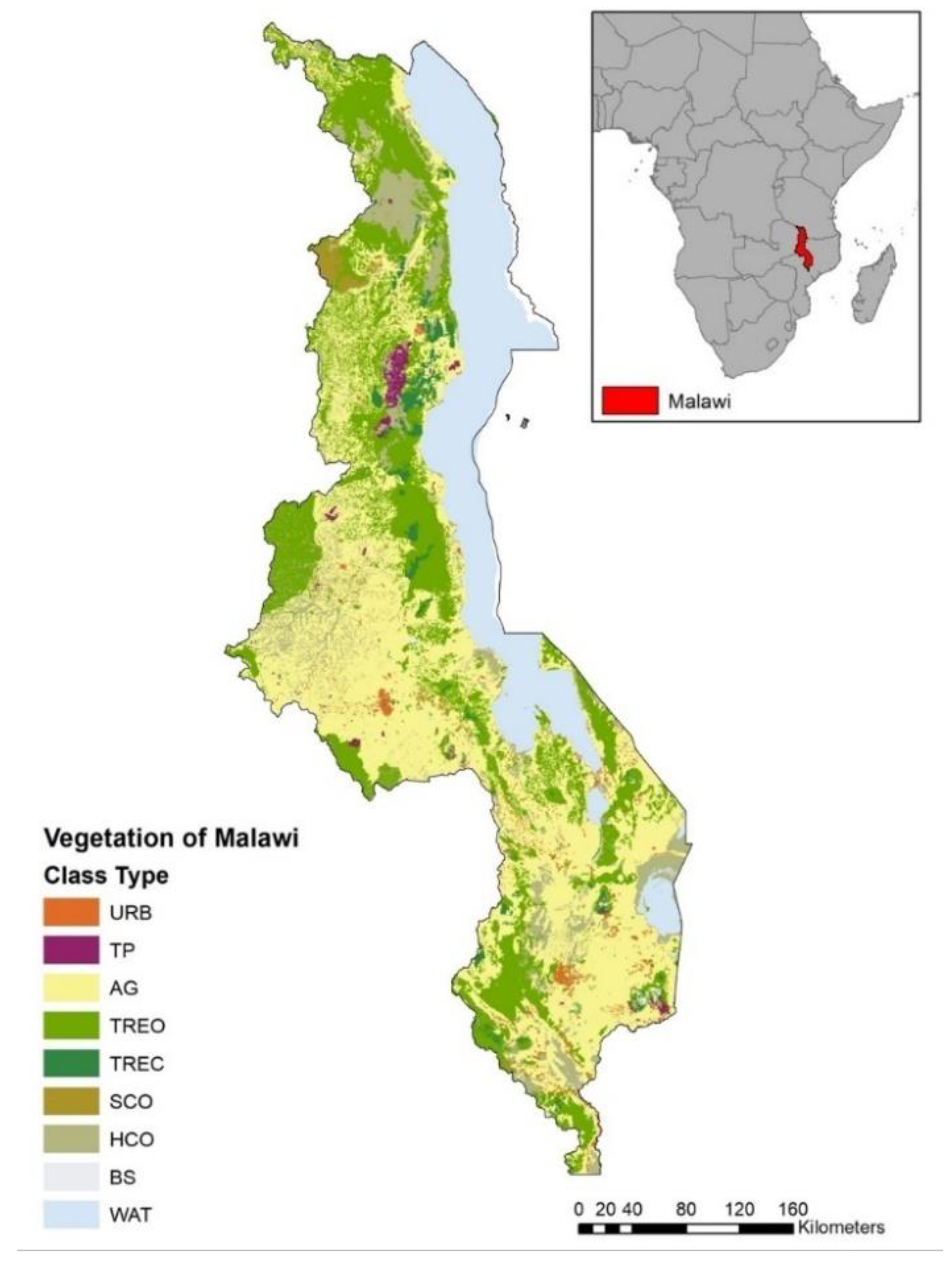
2.2. National Study Area
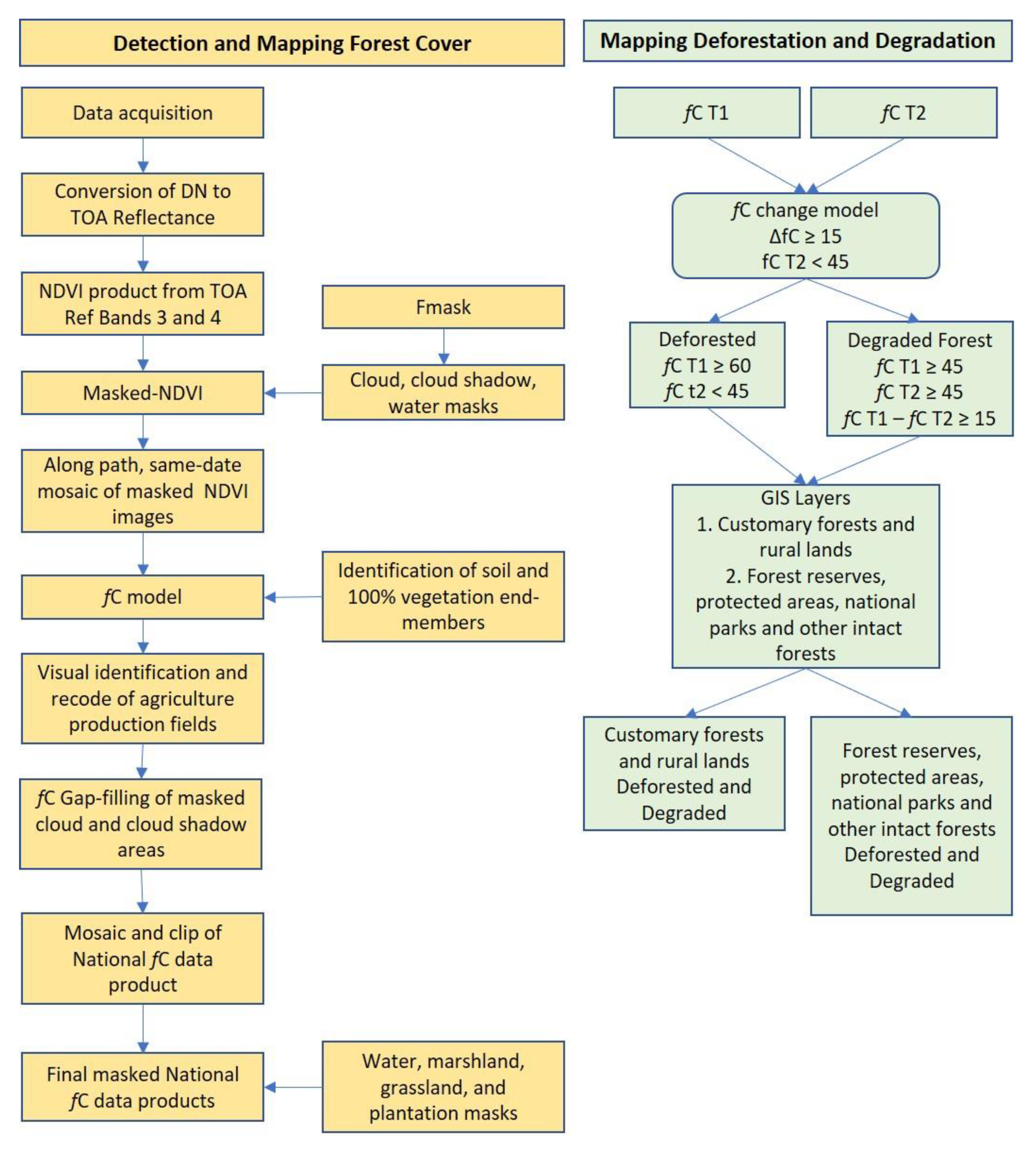
2.3. Data Processing
2.4. Deforestation and Forest Degradation Models
2.5. Delineation of Tree Cover and Forest Base Layer
3. Results
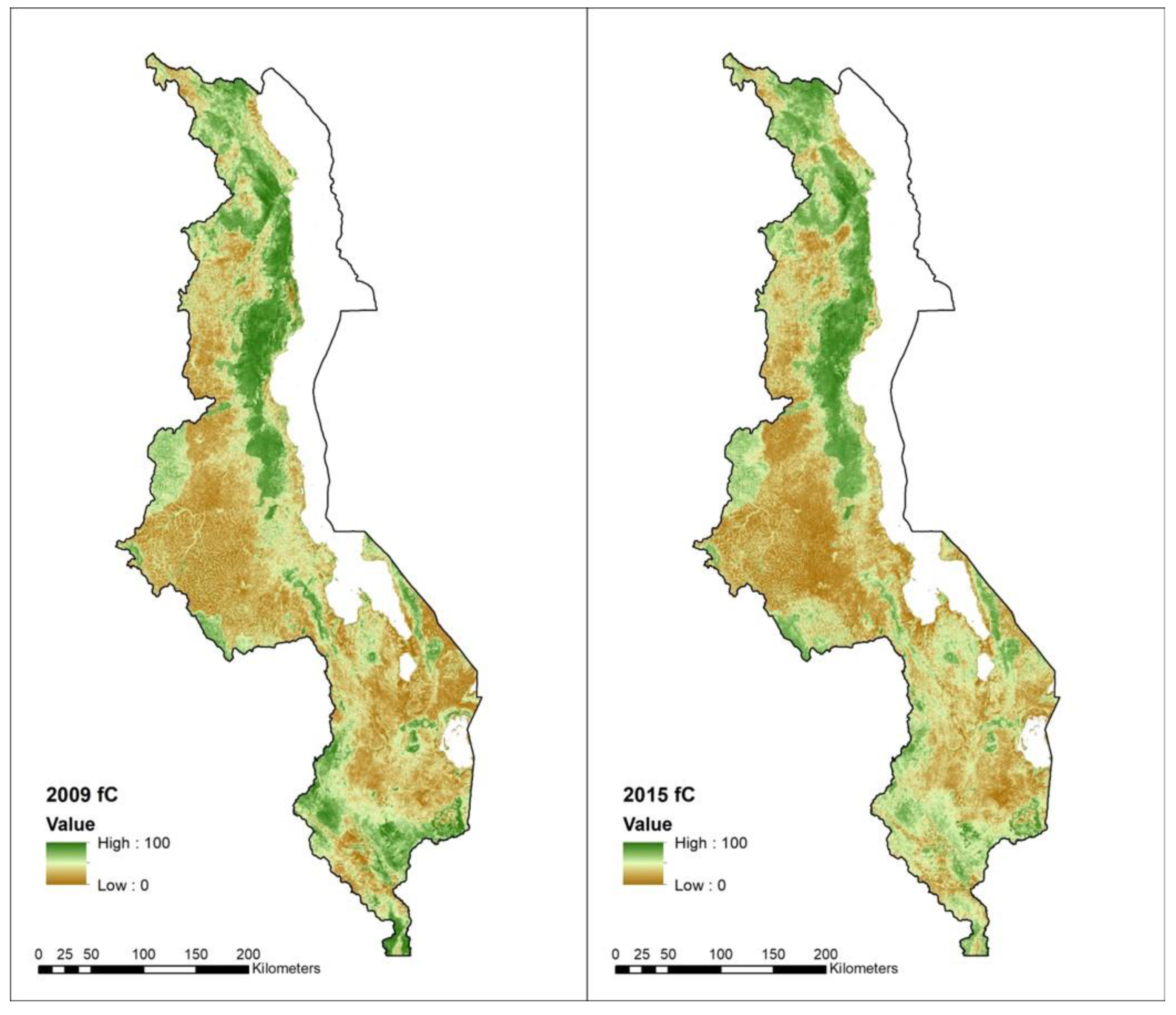
3.1. National Forest Area
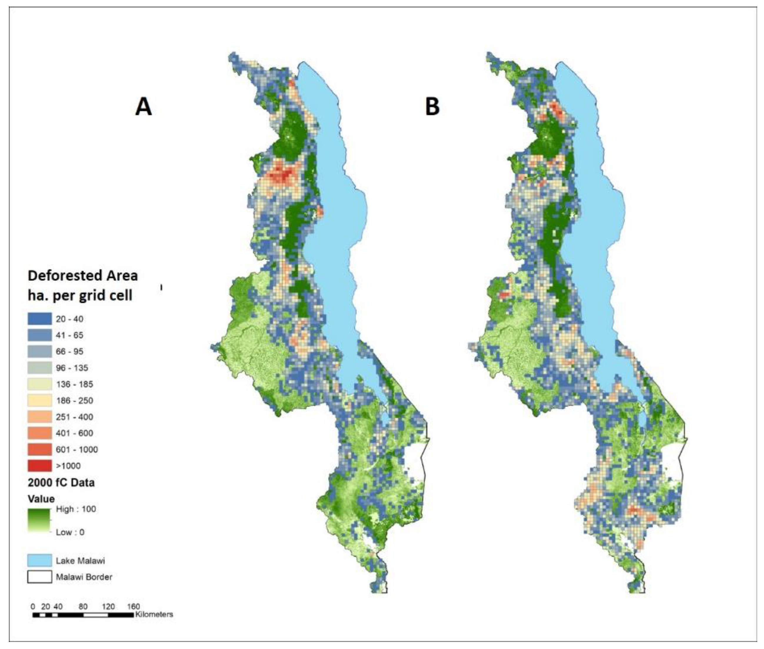
3.2. Deforested Areas and Annual Rates
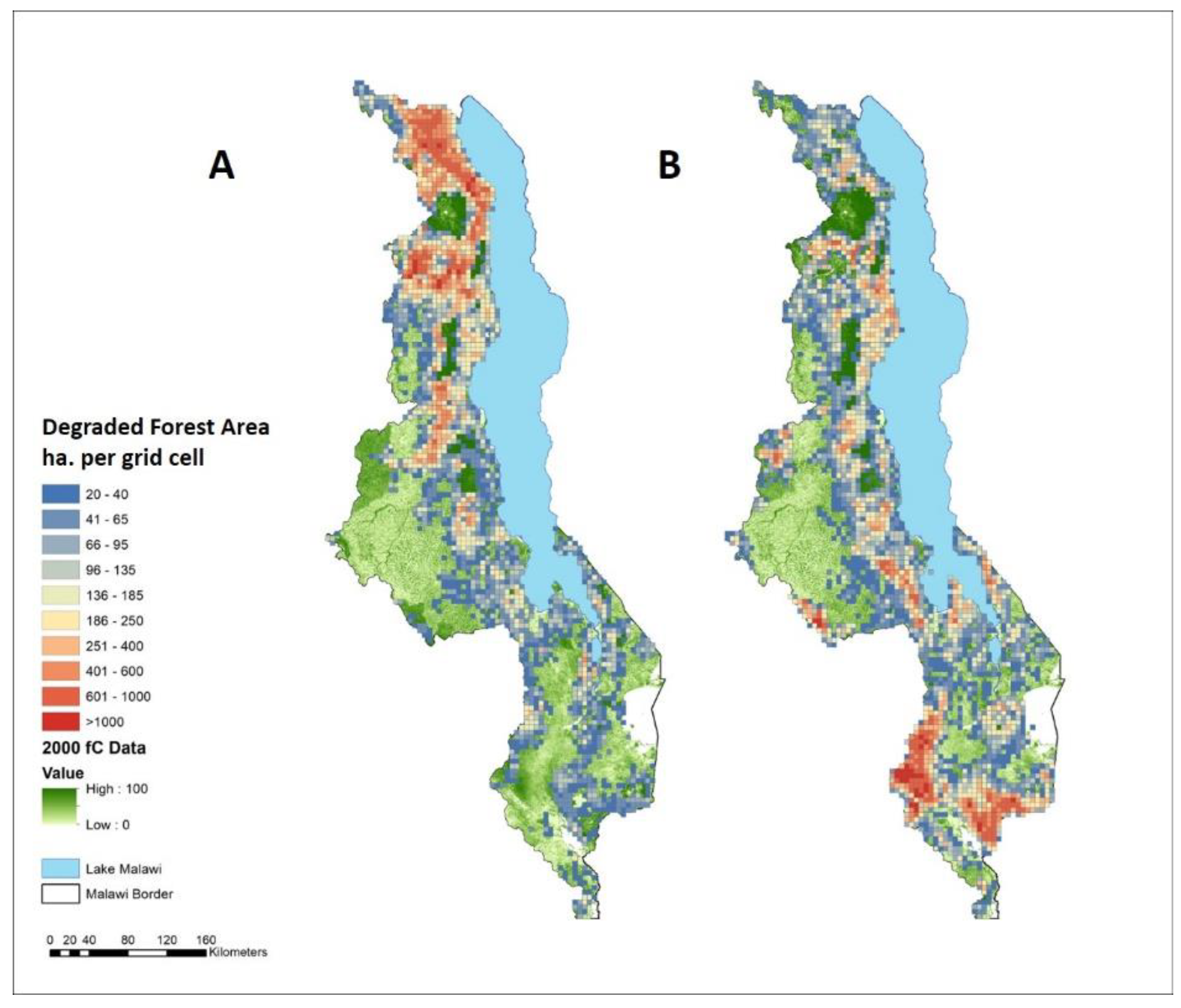
3.3. Forest Degradation Areas and Annual Rates
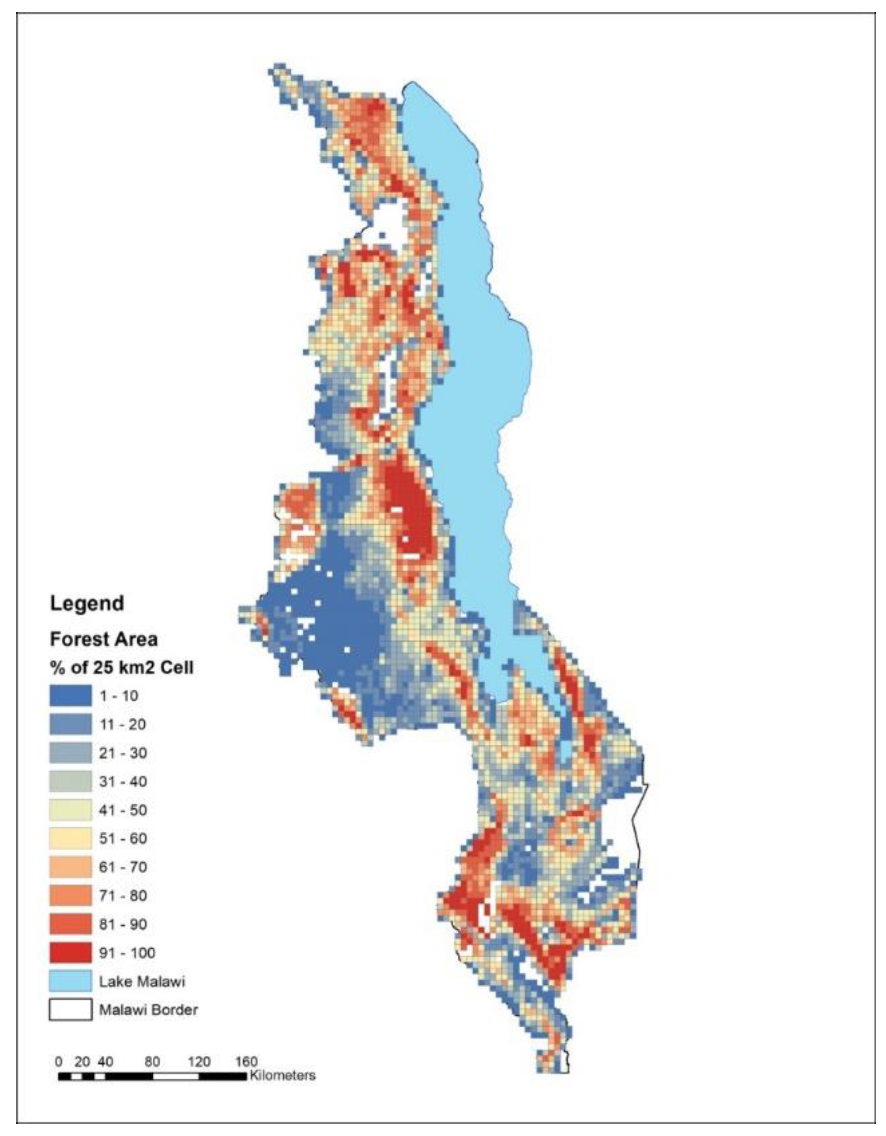
3.4. Analysis by District
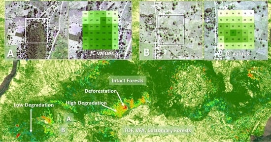
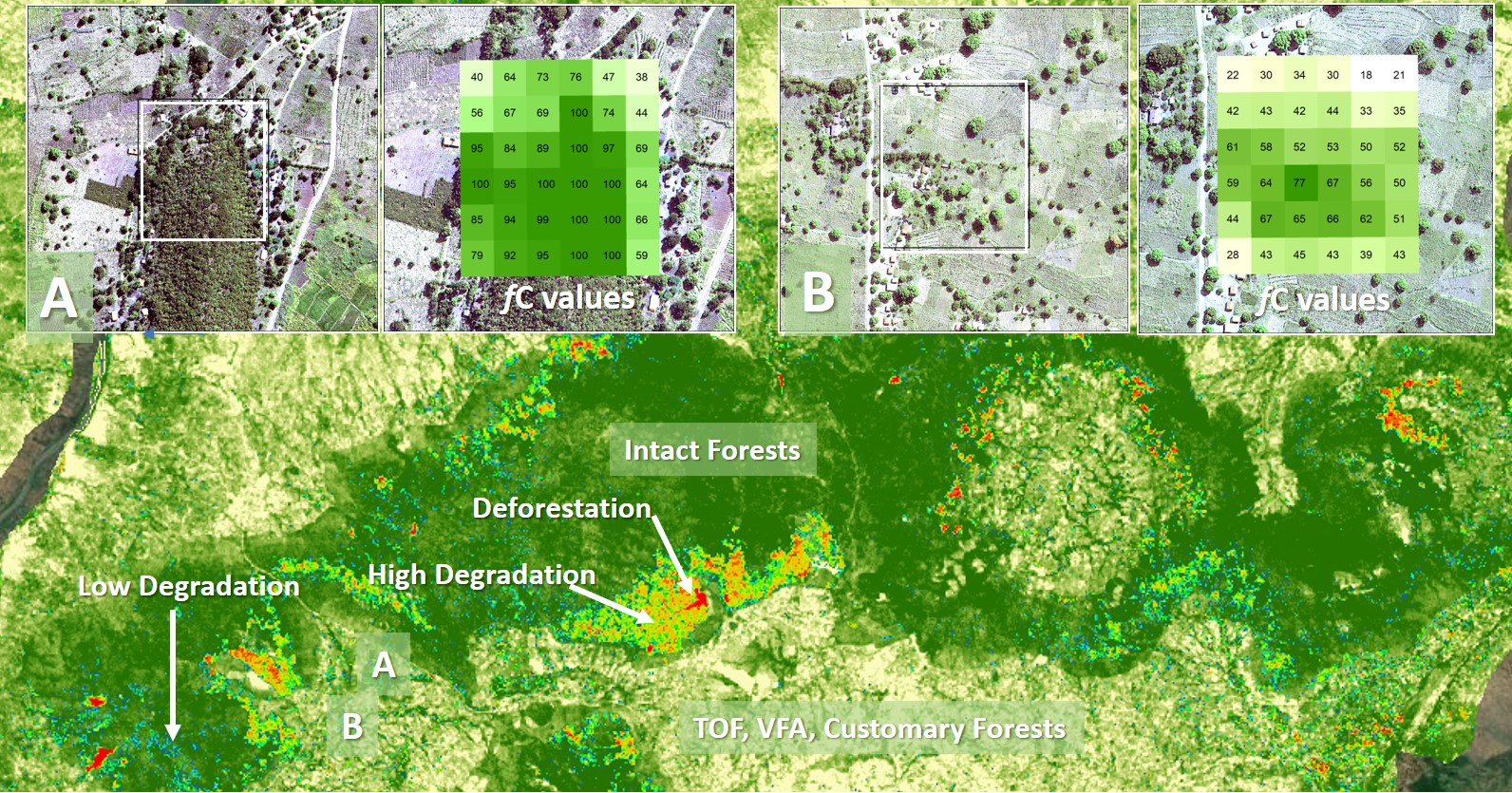
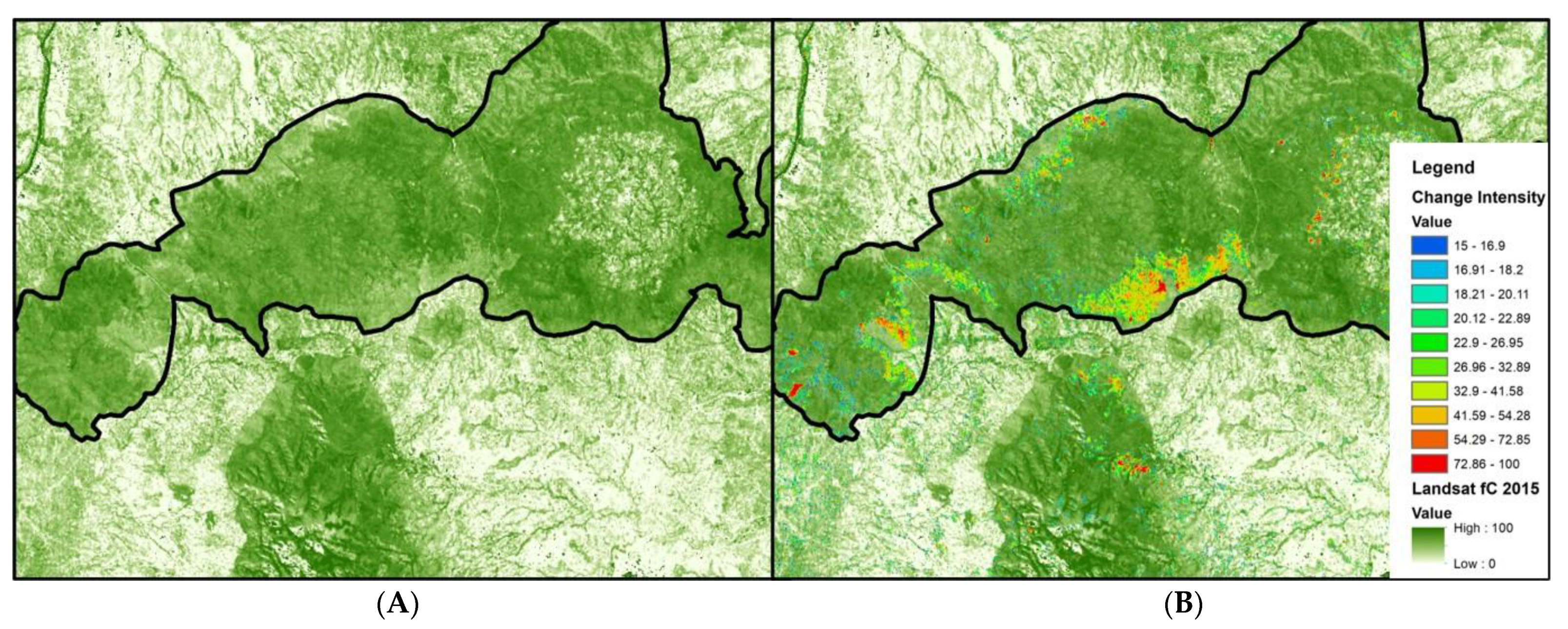
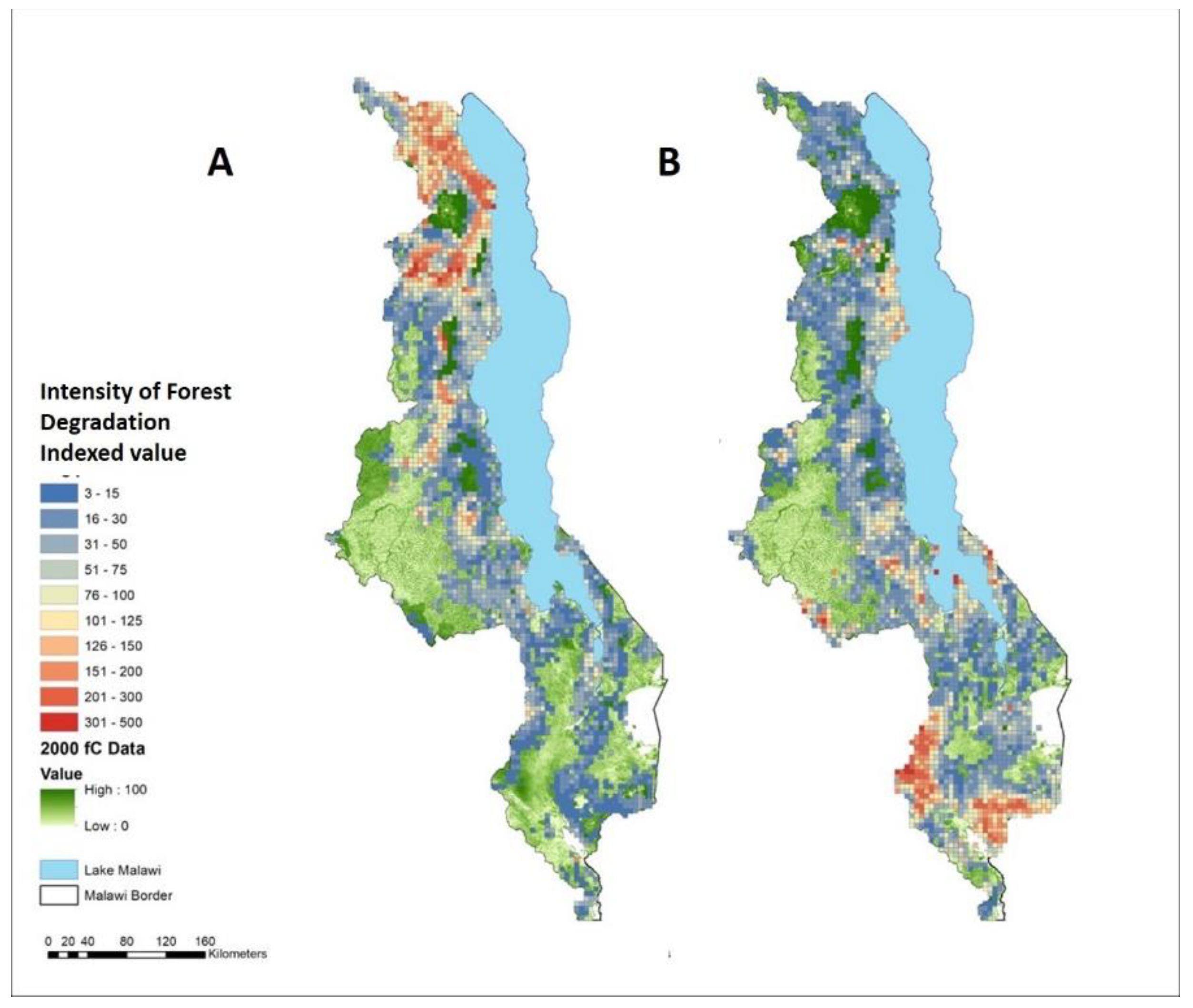
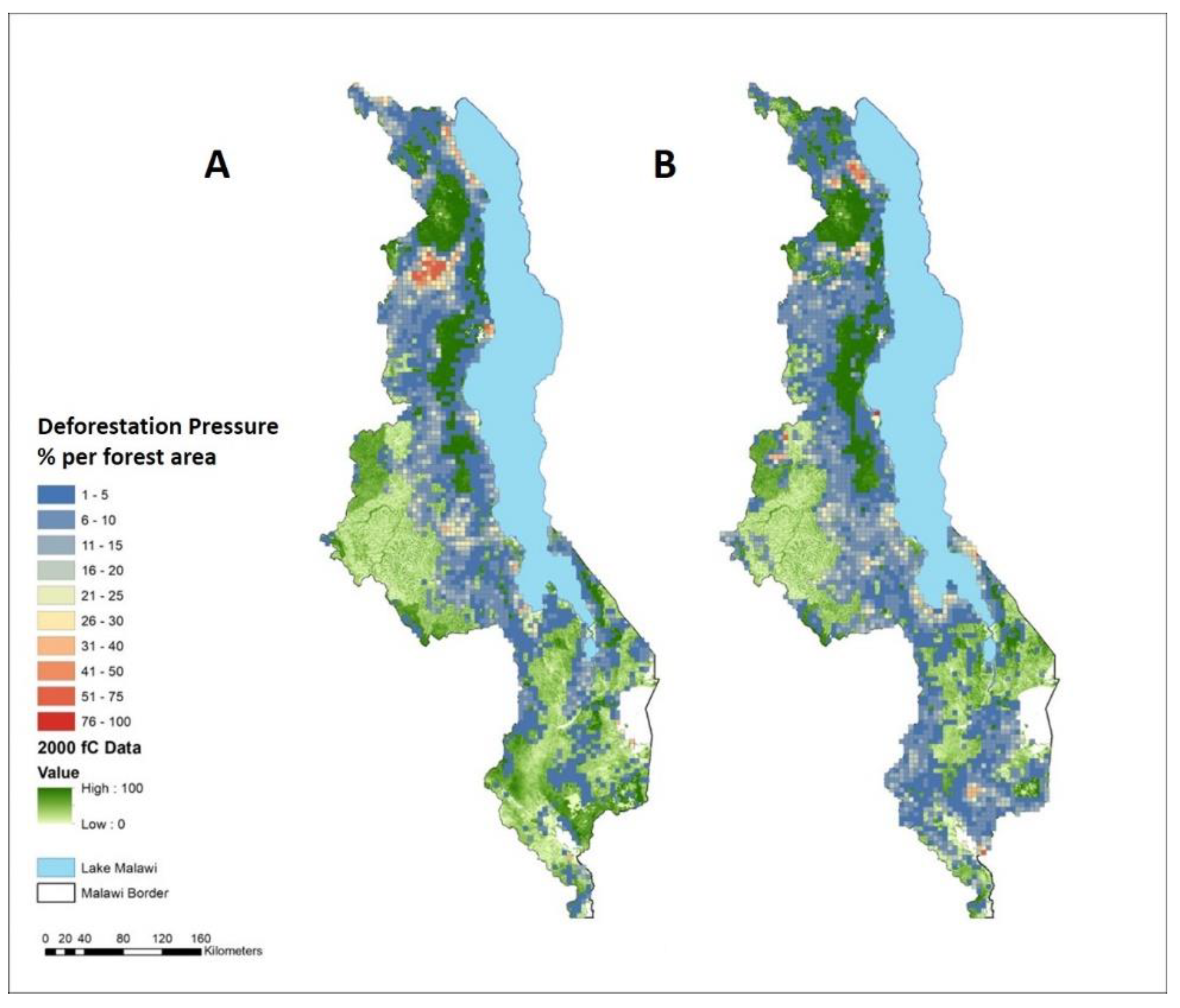
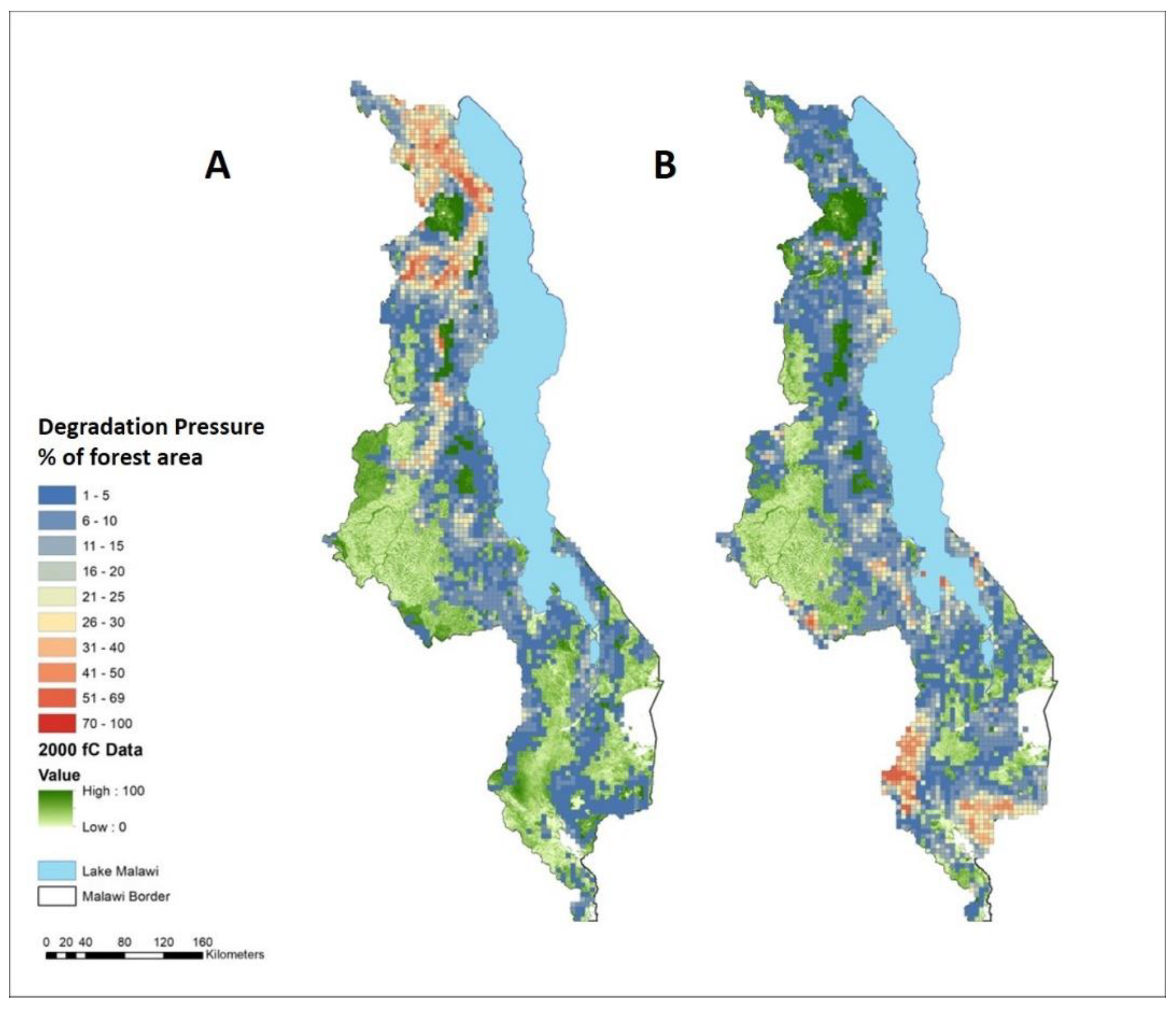
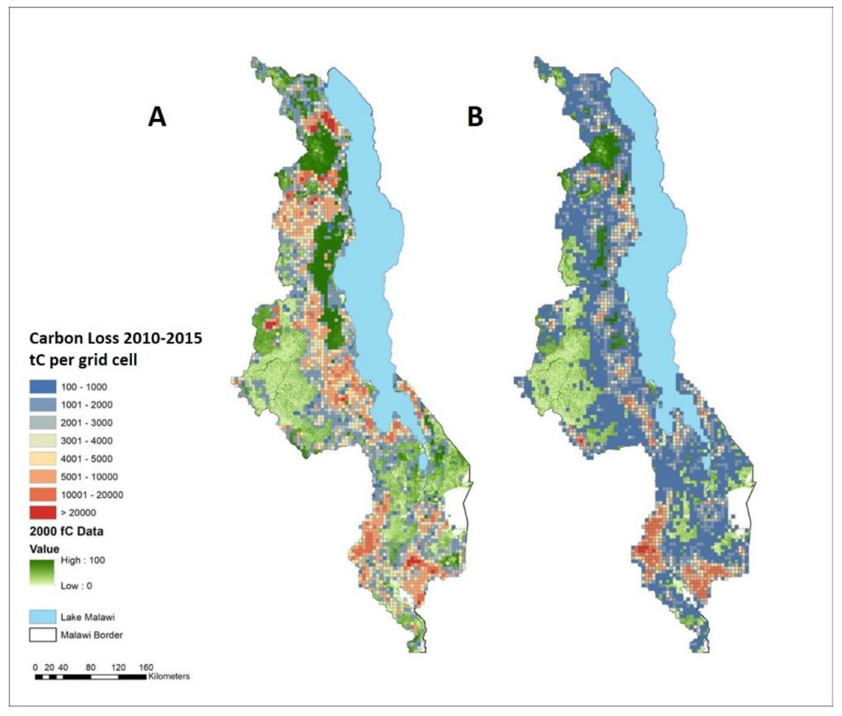
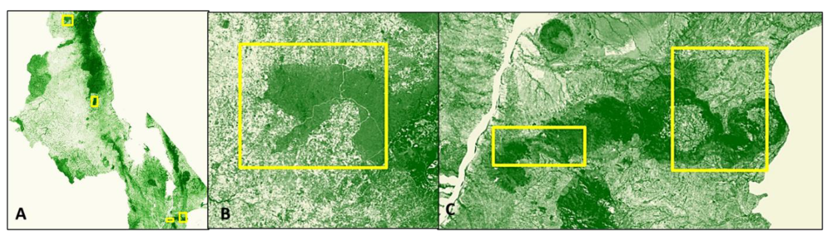
3.5. Mapping and Spatial Analysis
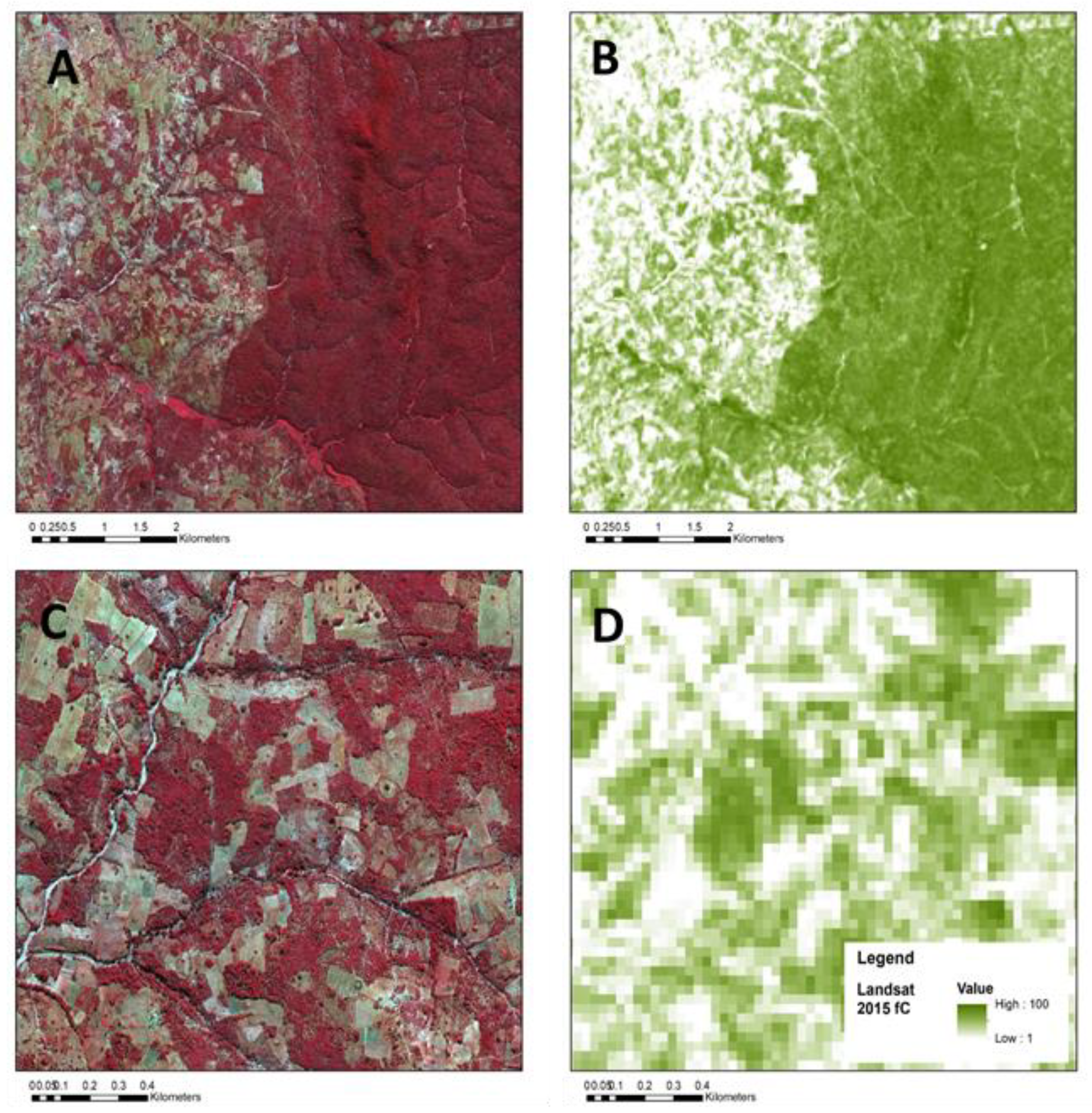
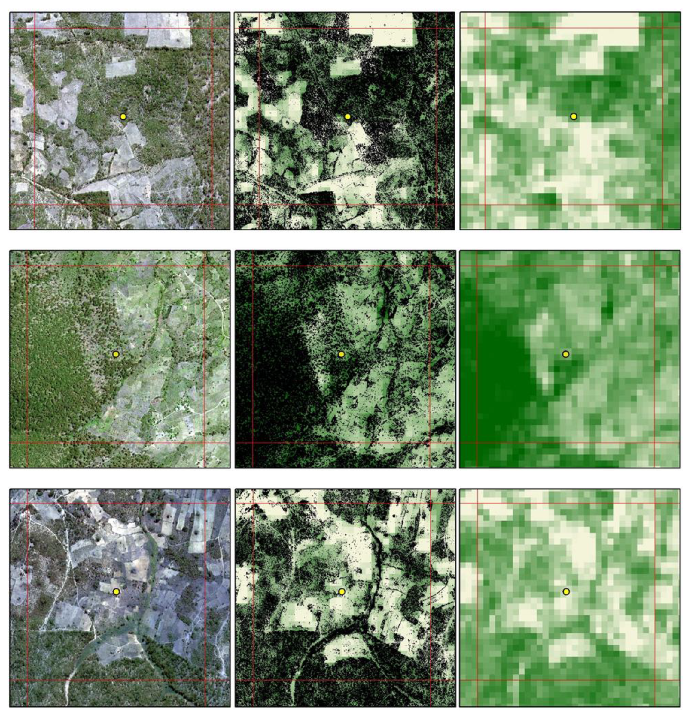
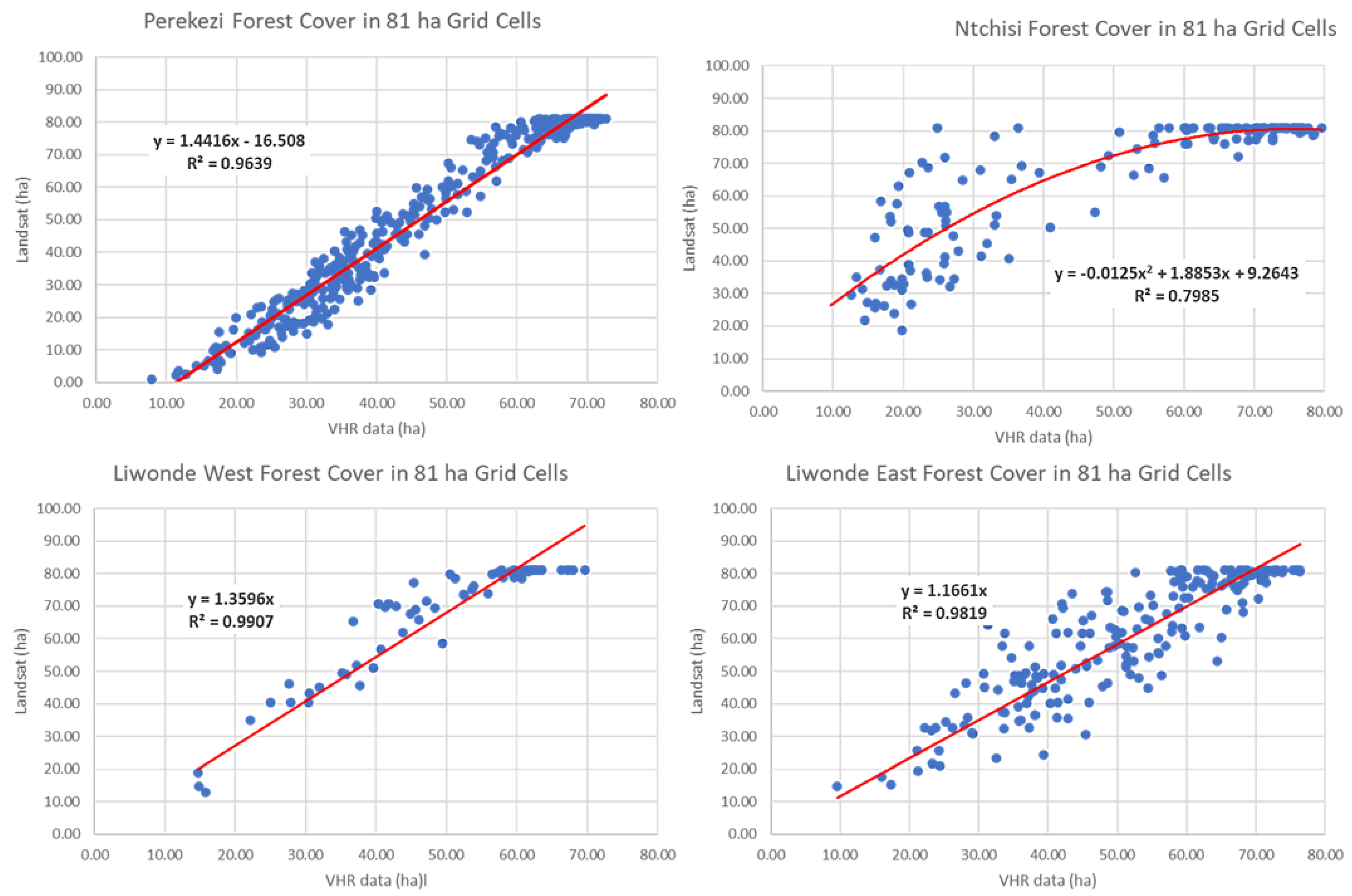
3.6. Accuracy Analysis and Quality Control
4. Discussion
5. Conclusions
5.1. New Robust High-Resolution Time-Series Maps of Forest, Deforestation and Forest Degradation Have Been Produced
5.2. New Tools to Support a REDD+ National Forest Monitoring System Have Been Demonstrated
5.3. The Way Forward and Next Steps
Author Contributions
Funding
Data Availability Statement
Acknowledgments
Conflicts of Interest
Appendix A
Appendix A.1. Data Processing

Appendix A.2. Accuracy Analysis


| Liwonde, Perekezi, Ntchisi (2015) | |
| Number of Field Plots—All Forest Areas | 250 |
| Count | |
| fC2015 ≥ 45 (Forest) | 245 |
| fC2015 < 45 (non Forest) | 5 |
| Percent Correct | 98% |
| Thuma-Dedza (2017) | |
| Number of Field Plots—All Forest Areas | 96 |
| Count | |
| fC2015 ≥ 45 (Forest) | 89 |
| fC2015 < 45 (non Forest) | 7 |
| Percent Correct | 93% |
| Landsat 2015 | Hyperspatial 2015 | |||
|---|---|---|---|---|
| fC < 45 | fC ≥ 45 | Sum | Producers Accuracy | |
| fC < 45 (non forest) | 8325 | 1938 | 10,263 | 81% |
| fC ≥ 45 (forest) | 5605 | 29,882 | 35,487 | 84% |
| Sum | 13,930 | 31,820 | 38,207 | |
| Users Accuracy | 60% | 94% | ||
| n= | 45,750 | |||
| Overall Accuracy | 84% | |||
References
- Hosonuma, N.; Herold, M.; De Sy, V.; De Fries, R.S.; Brockhaus, M.; Verchot, L.; Angelsen, A.; Romijn, E. An assessment of deforestation and forest degradation drivers in developing countries. Environ. Res. Lett. 2012, 7, 1–12. [Google Scholar] [CrossRef]
- McNicol, I.M.; Ryan, C.M.; Mitchard, E.T.A. Carbon losses from deforestation and widespread degradation offset by extensive growth in African woodlands. Nat. Commun. 2018, 9, 1–11. [Google Scholar] [CrossRef]
- Bhattarai, S.; Dons, K.; Pant, B. Assessing spatial patterns of forest degradation in dry Miombo woodland in Southern Tanzania. Cogent Environ. Sci. 2020, 6, 1801218. [Google Scholar] [CrossRef]
- Gao, Y.; Skutsch, M.; Paneque-Gálvez, J.; Ghilardi, A. Remote sensing of forest degradation: A review. Environ. Res. Lett. 2020, 15, 103001. [Google Scholar] [CrossRef]
- Penman, J.; Gytarsky, M.; Hiraishi, T.; Krug, T.; Kruger, D.; Pipatti, R.; Buendia, L.; Miwa, K.; Ngara, T.; Tanabe, K.; et al. Definitions and Methodological Options to Inventory Emissions from Direct Human-Induced Degradation of Forests and Devegetation of Other Vegetation Types; National Greenhouse Gas Inventories Programme, Intergovernmental Panel on Climate Change (IPCC): Geneva, Switzerland, 2013. [Google Scholar]
- Watson, R.; Noble, I.R.; Bolin, B.; Ravindranath, N.H.; Verardo, D.J.; Dokken, D.J. (Eds.) Land Use, Land-Use Change, and Forestry; A Special Report of the IPCC; Cambridge University Press: Cambridge, UK, 2000. [Google Scholar]
- Shukla, P.R.; Skea, J.; Calvo Buendia, E.; Masson-Delmotte, V.; Pörtner, H.-O.; Roberts, D.C.; Zhai, P.; Slade, R.; Connors, S.; van Diemen, R.; et al. Climate Change and Land: An IPCC Special Report on Climate Change, Desertification, Land Degradation, Sustainable Land Management, Food Security, and Greenhouse Gas Fluxes in Terrestrial Ecosystems; Intergovernmental Panel on Climate Change (IPCC): Geneva, Switzerland, 2019. [Google Scholar]
- Ribeiro, N.S.; Katerere, Y.; Chirwa, P.W.; Grundy, I.M. (Eds.) Miombo Woodlands in a Changing Environment: Securing the Resilience and Sustainability of People and Woodlands; Springer: New York, NY, USA, 2020; p. 269. [Google Scholar] [CrossRef]
- Kachamba, D.J.; Eid, T.; Gobakken, T. Above-and Belowground Biomass Models for Trees in the Miombo Woodlands of Malawi. Forests 2016, 7, 38. [Google Scholar] [CrossRef]
- Missanjo, E.; Kamanga-Thole, G. Estimation of biomass and carbon stock for Miombo Woodland in Dzalanyama Forest Reserve, Malawi. Res. J. Agric. For. Sci. 2015, 3, 7–12. [Google Scholar]
- Chidumayo, E.N.; Gumbo, D.J. The Dry Forests and Woodlands of Africa: Managing for Products and Services; Earthscan: London, UK, 2010. [Google Scholar]
- Kuyah, S.; Sileshi, G.W.; Njoloma, J.; Mng’Omba, S.; Neufeldt, H. Estimating aboveground tree biomass in three different miombo woodlands and associated land use systems in Malawi. Biomass Bioenergy 2014, 66, 214–222. [Google Scholar] [CrossRef]
- Zulu, L.C. The forbidden fuel: Charcoal, urban woodfuel demand and supply dynamics, community forest management and woodfuel policy in Malawi. Energy Policy 2010, 38, 3717–3730. [Google Scholar] [CrossRef]
- Sedano, F.; Silva, J.; Machoco, R.; Meque, C.; Sitoe, A.; Ribeiro, N.; Anderson, K.; Ombe, Z.; Baule, S.; Tucker, C.J. The impact of charcoal production on forest degradation: A case study in Tete, Mozambique. Environ. Res. Lett. 2016, 11, 094020. [Google Scholar] [CrossRef]
- Sedano, F.; Lisboa, S.N.; Duncanson, L.; Ribeiro, N.; Sitoe, A.; Sahajpal, R.; Hurtt, G.; Tucker, C.J. Monitoring intra and inter annual dynamics of forest degradation from charcoal production in Southern Africa with Sentinel—2 imagery. Int. J. Appl. Earth Obs. Geoinf. 2020, 92, 102184. [Google Scholar] [CrossRef]
- Bone, R.A.; Parks, K.E.; Hudson, M.D.; Tsirinzeni, M.; Willcock, S. Deforestation since independence: A quantitative assessment of four decades of land-cover change in Malawi. South. For. J. For. Sci. 2016, 79, 269–275. [Google Scholar] [CrossRef]
- Minde, I.J.; Kowero, G.; Ngugi, D.; Luhanga, J. Agricultural Land Expansion and Deforestation in Malawi. For. Trees Livelihoods 2001, 11, 167–182. [Google Scholar] [CrossRef]
- Ngwira, S.; Watanabe, T. An Analysis of the Causes of Deforestation in Malawi: A Case of Mwazisi. Land 2019, 8, 48. [Google Scholar] [CrossRef]
- Katumbi, N.; Nyengere, J.; Mkandawire, E. Drivers of deforestation and forest degradation in Dzalanyama forest reserve in Malawi. Int. J. Sci. Res. 2015, 6, 889–893. [Google Scholar]
- Mbow, C.; Brandt, M.; Ouedraogo, I.; De Leeuw, J.; Marshall, M. What four decades of earth observation tell us about land degradation in the Sahel? Remote Sens. 2015, 7, 4048–4067. [Google Scholar] [CrossRef]
- Gumbo, D.; Clendenning, J.; Martius, C.; Moombe, K.; Grundy, I.; Nasi, R.; Mumba, K.Y.; Ribeiro, N.; Kabwe, G.; Petrokofsky, G. How have carbon stocks in central and southern Africa’s miombo woodlands changed over the last 50 years? A systematic map of the evidence. Environ. Évid. 2018, 7, 16. [Google Scholar] [CrossRef]
- Chidumayo, E. Management implications of tree growth patterns in miombo woodlands of Zambia. For. Ecol. Manag. 2019, 436, 105–116. [Google Scholar] [CrossRef]
- Kundhlande, G.; Winterbottom, R.; Nyoka, B.I.; Reytar, K.; Ha, K.; Behr, D.C. Taking to Scale Tree-Based Systems that Enhance Food Security, Improve Resilience to Climate Change, and Sequester Carbon in Malawi; World Bank PROFOR: Washington, DC, USA, 2017; p. 56. [Google Scholar]
- Zomer, R.J.; Neufeldt, H.; Xu, J.; Ahrends, A.; Bossio, D.; Trabucco, A.; Van Noordwijk, M.; Wang, M. Global Tree Cover and Biomass Carbon on Agricultural Land: The contribution of agroforestry to global and national carbon budgets. Sci. Rep. 2016, 6, 29987. [Google Scholar] [CrossRef]
- Brandt, M.; Rasmussen, K.; Hiernaux, P.; Herrmann, S.; Tucker, C.J.; Tong, X.; Tian, F.; Mertz, O.; Kergoat, L.; Mbow, C.; et al. Reduction of tree cover in West African woodlands and promotion in semi-arid farmlands. Nat. Geosci. 2018, 11, 328–333. [Google Scholar] [CrossRef] [PubMed]
- Mbow, C.; Toensmeier, E.; Brandt, M.; Skole, D.; Dieng, M.; Garrity, D.; Poulter, B. Agroforestry as a solution for multiple climate change challenges in Africa. In Climate Change and Agriculture; Deryng, D., Ed.; Burleigh Dodds Science Publishing: Cambridge, UK, 2020. [Google Scholar]
- Stringer, L.C.; Dougill, A.J.; Mkwambisi, D.D.; Dyer, J.C.; Kalaba, F.K.; Mngoli, M. Challenges and opportunities for carbon management in Malawi and Zambia. Carbon Manag. 2012, 3, 159–173. [Google Scholar] [CrossRef]
- Gibbs, H.K.; Brown, S.; Niles, J.O.; Foley, J.A. Monitoring and estimating tropical forest carbon stocks: Making REDD a reality. Environ. Res. Lett. 2007, 2, 045023. [Google Scholar] [CrossRef]
- Chiotha, S.; Jamu, D.; Nagoli, J.; Likongwe, P.; Chanyenga, T.F. (Eds.) Socio-Ecological Resilience to Climate Change in a Fragile Ecosystem: The Case of the Lake Chilwa Basin, Malawi; Routledge: London, UK, 2018. [Google Scholar]
- Mbow, M.; Skole, D.; Dieng, M.; Justice, C.; Kwesha, D.; Mane, L.; El Gamri, M.; Von Vordzogbe, V.; Virji, H. Challenges and Prospects for REDD+ in Africa: Desk Review of REDD+ Implementation in Africa; GLP Report No. 5. GLP-IPO; GLP International Project Office: Copenhagen, Denmark, 2012. [Google Scholar]
- GOM. Malawi REDD+ Program National Forest Reference Level; Government of Malawi: Lilongwe, Malawi, 2019. [Google Scholar]
- Grainger, A.; Kim, J. Reducing Global Environmental Uncertainties in Reports of Tropical Forest Carbon Fluxes to REDD+ and the Paris Agreement Global Stocktake. Remote Sens. 2020, 12, 2369. [Google Scholar] [CrossRef]
- FAO. Voluntary Guidelines on National Forest Monitoring; Food and Agriculture Organization of the United Nations: Rome, Italy, 2017; 62p. [Google Scholar]
- Angelsen, A.; Boucher, D.; Brown, S.; Merckx, V.; Streck, C.; Zarin, D. Guidelines for REDD+ Reference Levels: Principles and Recommendations; Meridian Institute: Washington, DC, USA, 2011; 24p. [Google Scholar]
- Matricardi, E.A.; Skole, D.L.; Pedlowski, M.A.; Chomentowski, W.; Fernandes, L.C. Assessment of tropical forest degradation by selective logging and fire using Landsat imagery. Remote Sens. Environ. 2010, 114, 1117–1129. [Google Scholar] [CrossRef]
- Matricardi, E.A.; Skole, D.L.; Pedlowski, M.A.; Chomentowski, W. Assessment of forest disturbances by selective logging and forest fires in the Brazilian Amazon using Landsat data. Int. J. Remote Sens. 2012, 34, 1057–1086. [Google Scholar] [CrossRef]
- Matricardi, E.A.T.; Skole, D.L.; Costa, O.B.; Pedlowski, M.A.; Samek, J.H.; Miguel, E.P. Long-term forest degradation surpasses deforestation in the Brazilian Amazon. Science 2020, 369, 1378–1382. [Google Scholar] [CrossRef] [PubMed]
- Bullock, E.L.; Woodcock, C.E.; Souza, C.; Olofsson, P. Satellite-based estimates reveal widespread forest degradation in the Amazon. Glob. Chang. Biol. 2020, 26, 2956–2969. [Google Scholar] [CrossRef]
- Goetz, S.J.; Hansen, M.; Houghton, R.A.; Walker, W.; Laporte, N.; Busch, J. Measurement and monitoring needs, capabilities and potential for addressing reduced emissions from deforestation and forest degradation under REDD+. Environ. Res. Lett. 2015, 10, 123001. [Google Scholar] [CrossRef]
- Mayes, M.; Mustard, J.; Melillo, J.; Neill, C.; Nyadzi, G. Going beyond the green: Senesced vegetation material predicts basal area and biomass in remote sensing of tree cover conditions in an African tropical dry forest (miombo woodland) landscape. Environ. Res. Lett. 2017, 12, 085004. [Google Scholar] [CrossRef]
- Hansen, M.C.; Potapov, P.V.; Moore, R.; Hancher, M.; Turubanova, S.A.; Tyukavina, A.; Thau, D.; Stehman, S.V.; Goetz, S.J.; Loveland, T.R.; et al. High-resolution global maps of 21st-century forest cover change. Science 2013, 342, 850–853. [Google Scholar] [CrossRef]
- Melo, J.B.; Ziv, G.; Baker, T.R.; Carreiras, J.M.B.; Pearson, T.R.H.; Vasconcelos, M.J. Striking divergences in Earth Observation products may limit their use for REDD+. Environ. Res. Lett. 2018, 13, 104020. [Google Scholar] [CrossRef]
- Skole, D.L.; Cochrane, M.A. Observations of LCLUCC in regional case studies. In Land Change Science: Observing, Monitoring and Understanding Trajectories of Change on the Earth’s Surface; Kluwer Academic Publishers: Dordrecht, The Netherlands, 2004; p. 461. [Google Scholar]
- Petersen, R.; Davis, C.; Herold, M.; De Sy, V. Tropical Forest Monitoring: Exploring the Gaps between What Is Required and What Is Possible for Redd+ and Other Initiatives; Working Paper; World Resources Institute: Washington, DC, USA, 2018; 12p. [Google Scholar]
- Seymour, F.; Harris, N.L. Reducing tropical deforestation. Science 2019, 365, 756–757. [Google Scholar] [CrossRef]
- Campbell, B. (Ed.) The Miombo in Transition; Center for International Forestry Research: Bogor, Indonesia, 1996. [Google Scholar]
- World Bank. Malawi Country Environmental Analysis; World Bank: Washington, DC, USA, 2019; 160p. [Google Scholar]
- Coutts, C.; Holmes, T.; Jackson, A. Forestry policy, conservation activities, and ecosystem services in the remote Misuku Hills of Malawi. Forests 2019, 10, 1056. [Google Scholar] [CrossRef]
- Mauambeta, D.; Chitedze, D.; Mumba, R. Status of Forests and Tree Management in Malawi; Coordination Union for Rehabilitation of the Environment (CURE): Lilongwe, Malawi, 2010. [Google Scholar]
- Kamoto, J.; Clarkson, G.; Dorward, P.; Shepherd, D. Doing more harm than good? Community based natural resource management and the neglect of local institutions in policy development. Land Use Policy 2013, 35, 293–301. [Google Scholar] [CrossRef]
- FAO. Atlas of Malawi; Food and Agriculture Organization of the United Nations: Rome, Italy, 2013; p. 139. [Google Scholar]
- Chander, G.; Markham, B.L.; Helder, D.L. Summary of current radiometric calibration coefficients for Landsat MSS, TM, ETM+, and EO-1 ALI sensors. Remote Sens. Environ. 2009, 113, 893–903. [Google Scholar] [CrossRef]
- Zhu, Z.; Woodcock, C.E. Object-Based Cloud and Cloud Shadow Detection in Landsat Imagery. Remote Sens. Environ. 2012, 118, 83–94. [Google Scholar] [CrossRef]
- Zhu, Z.; Wang, S.; Woodcock, C.E. Improvement and expansion of the Fmask algorithm: Cloud, cloud shadow, and snow detection for Landsats 4–7, 8, and Sentinel 2 images. Remote Sens. Environ. 2015, 159, 269–277. [Google Scholar] [CrossRef]
- Roy, D.P.; Borak, J.S.; Devadiga, S.; Wolfe, R.E.; Zheng, M.; Descloitres, J. The MODIS Land product quality assessment approach. Remote Sens. Environ. 2002, 83, 62–76. [Google Scholar] [CrossRef]
- Rouse, J.W.; Haas, R.H.; Shell, J.A.; Deering, D.W. Monitoring vegetation systems in the Great Plains with ERTS-1. In Proceedings of the Third Earth Resources Technology Satellite Symposium, Washington, DC, USA, 10–14 December 1973; Goddard Space Flight Center: Washington, DC, USA, 1973; pp. 309–317. [Google Scholar]
- USAID. Malawi Foreign Assistance Act 118/119 Tropical Forest and Biodiversity Analysis; US Agency for International Development: Washington, DC, USA, 2019.
- Pearson, T.R.; Brown, S.; Murray, L.; Sidman, G. Greenhouse gas emissions from tropical forest degradation: An underestimated source. Carbon Balance Manag. 2017, 12, 3. [Google Scholar] [CrossRef]
- GOM. National Forest Policy; Government of the Republic of Malawi, Department of Forestry: Lilongwe, Malawi, 2016; p. 60.
- GOM. National Forest Landscape Restoration Strategy; Government of the Republic of Malawi, The Ministry of Natural Resources, Energy and Mining: Lilongwe, Malawi, 2017; 44p.
- GOM. Forest Landscape Restoration Opportunities Assessment for Malawi; Ministry of Natural Resources, Energy and Mining: Lilongwe, Malawi, 2017; 126p.
- GOM. National Charcoal Strategy; Government of the Republic of Malawi, The Ministry of Natural Resources, Energy and Mining: Lilongwe, Malawi, 2017; 44p.
- GOM. Malawi Submission of its First Nationally Determined Contribution. 2015. Available online: https://www4.unfccc.int/sites/NDCStaging/Pages/All.aspx (accessed on 4 March 2021).
- Haack, B.; Mahabir, R.; Kerkering, J. Remote sensing-derived national land cover land use maps: A comparison for Malawi. Geocarto Int. 2014, 30, 270–292. [Google Scholar] [CrossRef]
- Global Forest Watch. Forest Monitoring Designed for Action. Available online: https://www.globalforestwatch.org/ (accessed on 23 February 2021).
- GOM. Malawi State of Environment and Outlook Report: Environment for Sustainable Economic Growth; Environmental Affairs Department, Ministry of Natural Resources, Energy, and Environment: Lilongwe, Malawi, 2010; 302p.
- Kainja, S. Forest Outlook Studies in Africa–Malawi. 2000. Available online: http://www.fao.org/3/a-ab585e.pdf (accessed on 10 January 2021).


| Path/Row | Year 2000 | Year 2010 | Year 2015 | |||
|---|---|---|---|---|---|---|
| Scene ID | Acq. Date | Scene ID | Acq. Date | Scene ID | Acq. Date | |
| 167/70 | LE71670702002146SGS00 | 26 May 2002 | LT51670702008155JSA01 | 26 May 2008 | LC81670702015158LGN00 LC81670702014155LGN00 LC81670702015126LGN00 | 7 June 2015 4 June 2014 6 May 2015 |
| 167/71 | LE71670712002146SGS00 | 26 May 2002 | LT51670712009157JSA02 | 6 June 2009 | LC81670712015158LGN00 LC81670712014155LGN00 LC81670712015126LGN00 | 7 June 2015 4 June 2014 6 May 2015 |
| 167/72 | LE71670722002146SGS00 | 26 May 2002 | LE71670722009149ASN00 LT51670722010128JSA00 LT51670722008123JSA00 LT51670722008139MLK00 | 29 May 2009 8 May 2010 2 May 2008 18 May 2008 | LC81670722015158LGN00 LC81670722014155LGN00 LC81670722015126LGN00 | 7 June 2015 4 June 2014 6 May 2015 |
| 168/68 | LT51680681998134JSA00 LE71680682002073SGS00 | 5 May 1998 14 March 2002 | LT51680682009148JSA02 LT51680682009164MLK00 | 28 May 2009 13 June 2009 | LC81680682015229LGN00 | 17 August 2015 |
| 168/69 | LT51680691998134JSA00 | 14 May 1998 | LT51680692009148JSA02 LT51680692009180JSA02 LT51680692009148JSA02 | 28 May 2009 29 June 2009 28 May 2009 | LC81680692015165LGN00 LC81680692015133LGN00 | 14 June 2015 13 May 2015 |
| 168/70 | LT51680701998134JSA00 | 14 May 1998 | LT51680702009148JSA02 LT51680702009180JSA02 LT51680702009164MLK00 | 28 May 2009 29 June 2009 13 June 2009 | LC81680702015165LGN00 LC81680702015133LGN00 | 14 June 2015 13 May 2015 |
| 168/71 | LT51680711998134JSA00 | 14 May 1998 | LT51680712009148JSA02 LT51680712008130JSA00 | 28 May 2009 9 May 2008 | LC81680712015165LGN00 LC81680712015133LGN00 | 14 June 2015 13 May 2015 |
| 169/67 | LE71690672002128SGS00 LT51690671998157JSA00 LE71690672002192SGS00 LT51690671999144JSA00 | 8 May 2002 6 June 1998 11 July 2002 24 May 1999 | LT51690672009155JSA02 LT51690672008185JSA00 LE71690672009259ASN00 | 4 June 2009 3 July 2008 16 Sept. 2009 | LC81690672015156LGN00 | 5 June 2015 |
| 169/68 | LE71690682002128SGS00 | 8 May 2002 | LT51690682009155JSA02 | 4 June 2009 | LC81690682015156LGN00 | 5 June 2015 |
| 169/69 | LE71690692002128SGS00 | 8 May 2002 | LT51690692009155JSA02 | 4 June 2009 | LC81690692015156LGN00 | 5 June 2015 |
| 169/70 | LE71690702002128SGS00 LE71690702001125SGS00 | 8 May 2002 5 May 2001 | LT51690702009155JSA02 | 4 June 2009 | LC81690702015156LGN00 | 5 June 2015 |
| Area (ha) | ||||
|---|---|---|---|---|
| Land Class | MMU = 0.1 ha | MMU = 0.27 ha | MMU = 0.54 ha | MMU = 0.9 ha |
| Intact forests, forest reserves and protected areas | 2,561,722 | 2,556,864 | 2,547,390 | 2,530,602 |
| Customary forests on rural and customary lands | 1,703,708 | 1,666,980 | 1,624,057 | 1,570,397 |
| Total Area | 4,265,431 | 4,223,844 | 4,171,447 | 4,101,000 |
| 2000–2009: | Area (ha) | Rate (ha yr−1) | ||
| Deforested | Degraded | Deforested | Degraded | |
| Intact forests, forest reserves and protected areas | 39,661 | 248,576 | 4407 | 27,620 |
| Customary forests on agricultural and other land | 162,028 | 138,072 | 18,003 | 15,341 |
| TOTAL | 201,688 | 386,648 | 22,410 | 42,961 |
| 2010–2015: | Area (ha) | Rate (ha yr−1) | ||
| Deforested | Degraded | Deforested | Degraded | |
| Intact forests, forest reserves and protected areas | 136,040 | 309,694 | 22,673 | 5161 |
| Customary forests on agricultural and other land | 97,584 | 121,572 | 16,264 | 20,262 |
| TOTAL | 233,624 | 431,266 | 38,937 | 71,878 |
| Region | District | 2000–2009 Deforestation | 2000–2009 Degradation | 20010–2015 Deforestation | 2010–2015 Degradation |
|---|---|---|---|---|---|
| Northern | Chitipa | 10,458 | 47,618 | 8495 | 10,979 |
| Northern | Karonga | 14,540 | 74,749 | 15,820 | 12,837 |
| Northern | Mzimba | 64,966 | 87,013 | 35,180 | 32,717 |
| Northern | Mzuzu City | 566 | 1056 | 546 | 434 |
| Northern | Nkhata Bay | 6687 | 21,433 | 4776 | 27,317 |
| Northern | Rumphi | 13,936 | 41,037 | 12,364 | 20,021 |
| Sub Total | 111,154 | 272,906 | 77,182 | 104,306 | |
| Central | Dedza | 7250 | 9053 | 9402 | 18591 |
| Central | Dowa | 9178 | 6941 | 8378 | 6691 |
| Central | Kasungu | 10,622 | 17,064 | 16,358 | 20,357 |
| Central | Lilongwe | 4625 | 4001 | 7870 | 19,381 |
| Central | Lilongwe City | 655 | 366 | 734 | 591 |
| Central | Mchinji | 386 | 654 | 2425 | 2242 |
| Central | Nkhotakota | 8370 | 11,829 | 7369 | 15,877 |
| Central | Ntcheu | 5351 | 5860 | 5143 | 9703 |
| Central | Ntchisi | 8317 | 8257 | 7128 | 7921 |
| Central | Salima | 7150 | 6335 | 9258 | 10,559 |
| Sub Total | 61,904 | 70,361 | 74,065 | 111,914 | |
| Southern | Balaka | 4417 | 4848 | 1073 | 2275 |
| Southern | Blantyre | 1088 | 1808 | 1263 | 2833 |
| Southern | Blantyre City | 427 | 523 | 753 | 874 |
| Southern | Chikwawa | 1484 | 1999 | 15,507 | 56,150 |
| Southern | Chiradzulu | 587 | 814 | 2233 | 2226 |
| Southern | Machinga | 3019 | 3124 | 1969 | 6328 |
| Southern | Mangochi | 8875 | 13,840 | 14,406 | 30,130 |
| Southern | Mulanje | 881 | 2273 | 6641 | 18,733 |
| Southern | Mwanza | 384 | 1019 | 6408 | 21,297 |
| Southern | Neno | 1480 | 3159 | 6601 | 21,472 |
| Southern | Nsanje | 1869 | 2533 | 4171 | 5716 |
| Southern | Phalombe | 653 | 908 | 1442 | 2975 |
| Southern | Thyolo | 841 | 2554 | 11,467 | 34,940 |
| Southern | Zomba | 1964 | 2788 | 7344 | 7414 |
| Southern | Zomba City | 44 | 81 | 222 | 409 |
| Sub Total | 28,014 | 42,272 | 81,501 | 213,772 | |
| TOTAL (ha) | 201,072 | 385,539 | 232,748 | 429,992 | |
Publisher’s Note: MDPI stays neutral with regard to jurisdictional claims in published maps and institutional affiliations. |
© 2021 by the authors. Licensee MDPI, Basel, Switzerland. This article is an open access article distributed under the terms and conditions of the Creative Commons Attribution (CC BY) license (https://creativecommons.org/licenses/by/4.0/).
Share and Cite
Skole, D.L.; Samek, J.H.; Mbow, C.; Chirwa, M.; Ndalowa, D.; Tumeo, T.; Kachamba, D.; Kamoto, J.; Chioza, A.; Kamangadazi, F. Direct Measurement of Forest Degradation Rates in Malawi: Toward a National Forest Monitoring System to Support REDD+. Forests 2021, 12, 426. https://doi.org/10.3390/f12040426
Skole DL, Samek JH, Mbow C, Chirwa M, Ndalowa D, Tumeo T, Kachamba D, Kamoto J, Chioza A, Kamangadazi F. Direct Measurement of Forest Degradation Rates in Malawi: Toward a National Forest Monitoring System to Support REDD+. Forests. 2021; 12(4):426. https://doi.org/10.3390/f12040426
Chicago/Turabian StyleSkole, David L., Jay H. Samek, Cheikh Mbow, Michael Chirwa, Dan Ndalowa, Tangu Tumeo, Daud Kachamba, Judith Kamoto, Alfred Chioza, and Francis Kamangadazi. 2021. "Direct Measurement of Forest Degradation Rates in Malawi: Toward a National Forest Monitoring System to Support REDD+" Forests 12, no. 4: 426. https://doi.org/10.3390/f12040426
APA StyleSkole, D. L., Samek, J. H., Mbow, C., Chirwa, M., Ndalowa, D., Tumeo, T., Kachamba, D., Kamoto, J., Chioza, A., & Kamangadazi, F. (2021). Direct Measurement of Forest Degradation Rates in Malawi: Toward a National Forest Monitoring System to Support REDD+. Forests, 12(4), 426. https://doi.org/10.3390/f12040426