
Mangrove Forest Landcover Changes in Coastal Vietnam: A Case Study from 1973 to 2020 in Thanh Hoa and Nghe An Provinces

 ,
,
Abstract
1. Introduction
- (i)
- determine the spatial extent of the mangrove forest in Thanh Hoa and Nghe An provinces using remotely-sensed satellite data;
- (ii)
- estimate changes in the spatial extent of the forest in Thanh Hoa and Nghe An provinces from 1973 to 2020; and
- (iii)
- document the factors responsible for the changes in the areal extent of the mangrove forest.
2. Materials and Methods
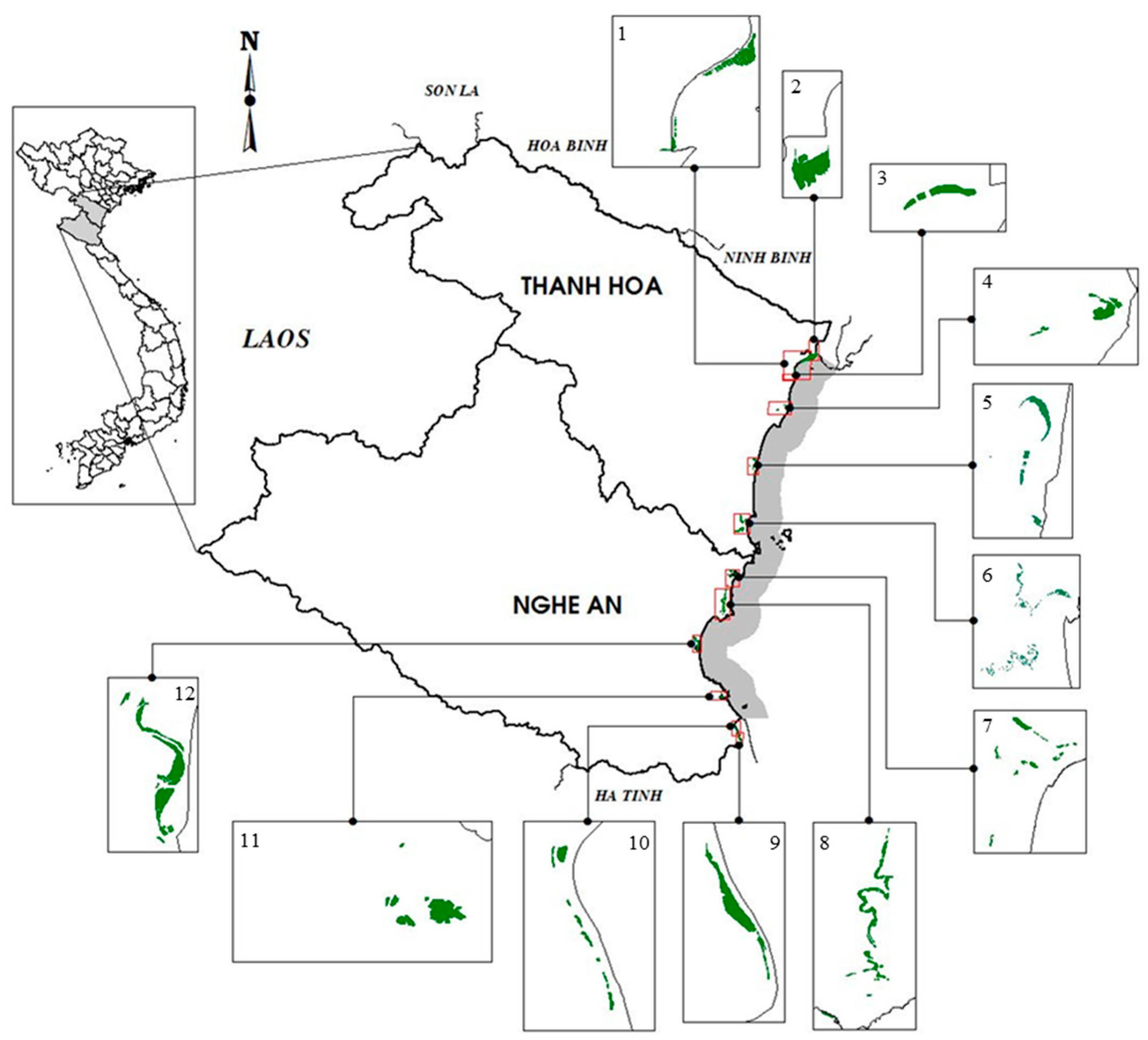
2.1. Study Area
2.2. Image Selection
2.3. Data Pre-Processing
2.4. Land Cover Classification
2.5. Accuracy Assessment
3. Results
3.1. Classification and Accuracy Assessment
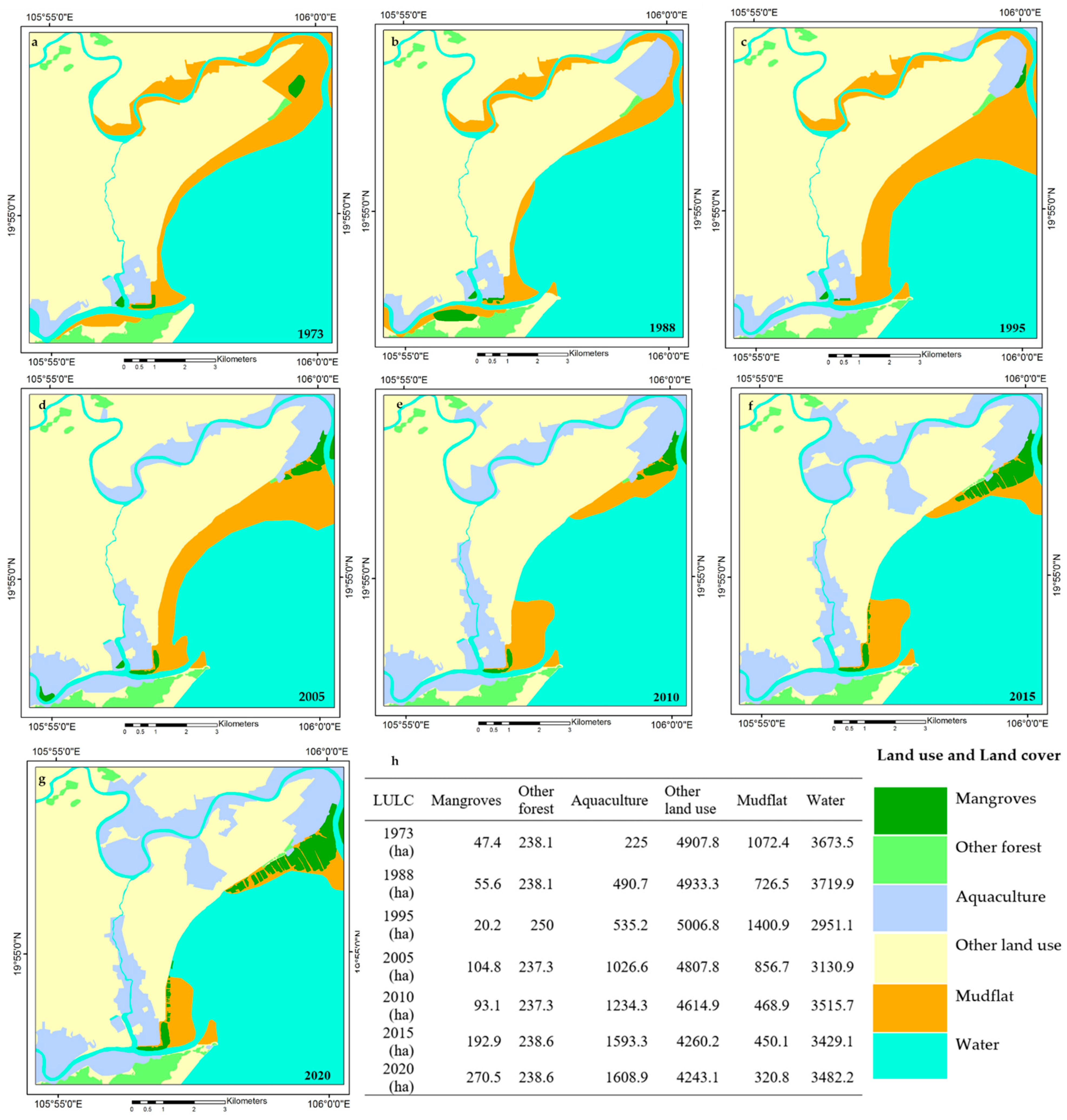
3.2. LULC Changes in Thanh Hoa and Nghe An Provinces from 1973 to 2020
3.3. Change in Mangrove Cover at the District Level from 1973 to 2020
3.4. Drivers of Change in Mangrove Cover
- Aquaculture
- Other land use
- Afforestation
4. Discussion
4.1. Mangrove Extent
4.2. Drivers of Change Over Time
- Aquaculture
- Other land use
- Natural factors
- Afforestation
- Classification and accuracy assessment
5. Conclusions
Supplementary Materials
Author Contributions
Funding
Institutional Review Board Statement
Informed Consent Statement
Data Availability Statement
Acknowledgments
Conflicts of Interest
References
- Koch, E.W.; Barbier, E.B.; Silliman, B.R.; Reed, D.J.; Perillo, G.M.; Hacker, S.D.; Granek, E.F.; Primavera, J.H.; Muthiga, N.; Polasky, S.; et al. Non-linearity in ecosystem services: Temporal and spatial variability in coastal protection. Front. Ecol. Environ. 2009, 7, 29–37. [Google Scholar] [CrossRef]
- Nagelkerken, I.; Blaber, S.; Bouillon, S.; Green, P.; Haywood, M.; Kirton, L.; Meynecke, J.-O.; Pawlik, J.; Penrose, H.M.; Sasekumar, A.; et al. The habitat function of mangroves for terrestrial and marine fauna: A review. Aquat. Bot. 2008, 89, 155–185. [Google Scholar] [CrossRef]
- Ouyang, X.; Lee, S.Y.; Connolly, R.M.; Kainz, M.J. Spatially-explicit valuation of coastal wetlands for cyclone mitigation in Australia and China. Sci. Rep. 2018, 8, 3035. [Google Scholar] [CrossRef]
- Hochard, J.P.; Hamilton, S.; Barbier, E.B. Mangroves shelter coastal economic activity from cyclones. Proc. Natl. Acad. Sci. USA 2019, 116, 12232–12237. [Google Scholar] [CrossRef] [PubMed]
- Atwood, T.B.; Connolly, R.M.; Almahasheer, H.; Carnell, P.E.; Duarte, C.M.; Lewis, C.J.E.; Irigoien, X.; Kelleway, J.J.; Lavery, P.S.; Macreadie, P.I.; et al. Global patterns in mangrove soil carbon stocks and losses. Nat. Clim. Chang. 2017, 7, 523–528. [Google Scholar] [CrossRef]
- Adame, M.F.; Brown, C.J.; Bejarano, M.; Herrera-Silveira, J.A.; Ezcurra, P.; Kauffman, J.B.; Birdsey, R.A. The undervalued contribution of mangrove protection in Mexico to carbon emission targets. Conserv. Lett. A J. Soc. Conversat. Biol. 2018, 11, e12445. [Google Scholar] [CrossRef]
- Lovelock, C.E.; Cahoon, D.R.; Friess, D.A.; Guntenspergen, G.R.; Krauss, K.W.; Reef, R.; Rogers, K.; Saunders, M.L.; Sidik, F.; Swales, A.; et al. The vulnerability of Indo-Pacific mangrove forests to sea-level rise. Nature 2015, 526, 559–563. [Google Scholar] [CrossRef]
- Schuerch, M.; Spencer, T.; Temmerman, S.; Kirwan, M.L.; Wolff, C.; Lincke, D.; McOwen, C.J.; Pickering, M.D.; Reef, R.; Vafeidis, A.T.; et al. Future response of global coastal wetlands to sea-level rise. Nature 2018, 561, 231–234. [Google Scholar] [CrossRef]
- Valiela, I.; Bowen, J.L.; York, J.K. Mangrove Forests: One of the World’s Threatened Major Tropical Environments: At least 35% of the area of mangrove forests has been lost in the past two decades, losses that exceed those for tropical rain forests and coral reefs, two other well-known threatened environments. Bioscience 2001, 51, 807–815. [Google Scholar]
- Hamilton, S.; Casey, D. Creation of a high spatio-temporal resolution global database of continuous mangrove forest cover for the 21st century (CGMFC-21). Glob. Ecol. Biogeogr. 2016, 25, 729–738. [Google Scholar] [CrossRef]
- Friess, D.A.; Rogers, K.; Lovelock, C.E.; Krauss, K.W.; Hamilton, S.E.; Lee, S.Y.; Lucas, R.; Primavera, J.; Rajkaran, A.; Shi, S. The state of the world’s mangrove forests: Past, present, and future. Annu. Rev. Environ. Resour. 2019, 44, 89–115. [Google Scholar] [CrossRef]
- Mejía-Rentería, J.C.; Castellanos-Galindo, G.A.; Cantera-Kintz, J.R.; Hamilton, S.E. A comparison of Colombian Pacific mangrove extent estimations: Implications for the conservation of a unique Neotropical tidal forest. Estuar. Coast. Shelf Sci. 2018, 212, 233–240. [Google Scholar] [CrossRef]
- Hong, P.N.; San, H.T. Mangroves of Vietnam; IUCN: Bangkok, Thailand, 1993. [Google Scholar]
- Ratner, B.D. Wetlands Management in Vietnam: Issues and Perspectives; WorldFish: Penang, Malaysia, 2003. [Google Scholar]
- Tuan, L.; Yukihiro, M.; Dao, P.; Tho, N.H.; Dao, Q. Environmental management in mangrove areas. Environ. Inform. Arch. 2003, 1, 38–52. [Google Scholar]
- FAO. Global Forest Resources Assessment 2015 Desk Reference; Food and Agriculture Organization of the United Nations: Rome, Italy, 2015. [Google Scholar]
- Tuan, L.; Hong, P.N. Problems of coastal environment and restoration in Vietnam. In Proceedings of the Third International Workshop Yearbook of Vietnam, Hanoi, Vietnam, 5–7 December 2008. (In Vietnamese). [Google Scholar]
- Forest Inventory and Planning Institute. Results of National Forest Survey Following Decision No 405/TTg-KTN of the Prime Minister, Dated 16 March 2007; Forest Inventory and Planning Institute (FIPI): Hanoi, Vietnam, 2007. (In Vietnamese) [Google Scholar]
- MARD. Decision No. 3158/QD-BNN-TCLN “Announcing Forest Status in 2015–2016”; MARD: Hanoi, Vietnam, 2016. [Google Scholar]
- MARD. Announcement of National Forest Status in 2019; MARD: Hanoi, Vietnam, 2020. (In Vietnamese) [Google Scholar]
- Wang, X.; Mahul, O.; Stutley, C. Weathering the Storm: Options for Disaster Risk Financing in Vietnam; World Bank: Washington, DC, USA, 2010. [Google Scholar]
- Takagi, H. Statistics on typhoon landfalls in Vietnam: Can recent increases in economic damage be attributed to storm trends? Urban. Clim. 2019, 30, 100506. [Google Scholar] [CrossRef]
- Tinh, D.Q. Vietnam Country Report 1999; Asian Disaster Reducton Center (ADRC): Kobe, Japan, 1999. [Google Scholar]
- Takagi, H.; Esteban, M.; Thao, N.D. Introduction: Coastal Disasters and Climate Change in Vietnam; Elsevier: Amsterdam, The Netherlands, 2014. [Google Scholar]
- Hardisky, M.; Gross, M.; Klemas, V. Remote sensing of coastal wetlands. BioScience 1986, 36, 453–460. [Google Scholar] [CrossRef]
- Green, E.; Clark, C.D.; Mumby, P.J.; Edwards, A.J.; Ellis, A.C. Remote sensing techniques for mangrove mapping. Int. J. Remote Sens. 1998, 19, 935–956. [Google Scholar] [CrossRef]
- Blasco, F.; Gauquelin, T.; Rasolofoharinoro, M.; Denis, J.; Aizpuru, M.; Caldairou, V. Recent advances in mangrove studies using remote sensing data. Mar. Freshw. Res. 1998, 49, 287–296. [Google Scholar] [CrossRef]
- Heumann, B.W. Satellite remote sensing of mangrove forests: Recent advances and future opportunities. Prog. Phys. Geogr. 2011, 35, 87–108. [Google Scholar] [CrossRef]
- Held, A.; Ticehurst, C.; Lymburner, L.; Williams, N. High resolution mapping of tropical mangrove ecosystems using hyperspectral and radar remote sensing. Int. J. Remote Sens. 2003, 24, 2739–2759. [Google Scholar] [CrossRef]
- Tuan, V.; Oppelt, N.; Leinenkugel, P.; Kuenzer, C. Remote sensing in mapping mangrove ecosystems—An object-based approach. Remote Sens. 2013, 5, 183–201. [Google Scholar]
- Lucas, R.; Van De Kerchove, R.; Otero, V.; Lagomasino, D.; Fatoyinbo, L.; Omar, H.; Satyanarayana, B.; Dahdouh-Guebas, F. Structural characterisation of mangrove forests achieved through combining multiple sources of remote sensing data. Remote Sens. Environ. 2020, 237, 111543. [Google Scholar] [CrossRef]
- Bindu, G.; Rajan, P.; Jishnu, E.; Joseph, K.A. Carbon stock assessment of mangroves using remote sensing and geographic information system. Egypt. J. Remote Sens. Space Sci. 2020, 23, 1–9. [Google Scholar] [CrossRef]
- Thi, V.T.; Xuan, A.T.T.; Nguyen, H.P.; Dahdouh-Guebas, F.; Koedam, N. Application of remote sensing and GIS for detection of long-term mangrove shoreline changes in Mui Ca Mau, Vietnam. Biogeosciences 2014, 11, 3781. [Google Scholar]
- Thu, P.M.; Populus, J. Status and changes of mangrove forest in Mekong Delta: Case study in Tra Vinh, Vietnam. Estuar. Coast. Shelf Sci. 2007, 71, 98–109. [Google Scholar] [CrossRef]
- Luong, N.V.; Tateishi, R.; Hoan, N.T. Analysis of an impact of succession in mangrove forest association using remote sensing and GIS technology. J. Geogr. Geol. 2015, 7, 106. [Google Scholar] [CrossRef][Green Version]
- Lien, P.T.; Brabyn, L. Monitoring mangrove biomass change in Vietnam using SPOT images and an object-based approach combined with machine learning algorithms. ISPRS J. Photogramm. Remote Sens. 2017, 128, 86–97. [Google Scholar]
- Tuan, V.; Kuenzer, C.; Oppelt, N. How remote sensing supports mangrove ecosystem service valuation: A case study in Ca Mau province, Vietnam. Ecosyst. Serv. 2015, 14, 67–75. [Google Scholar]
- Son, N.T.; Chen, C.-F.; Chang, N.-B.; Chen, C.-R.; Chang, L.-Y.; Thanh, B.-X. Mangrove mapping and change detection in Ca Mau Peninsula, Vietnam, using Landsat data and object-based image analysis. IEEE J. Sel. Top. Appl. Earth Obs. Remote Sens. 2014, 8, 503–510. [Google Scholar] [CrossRef]
- Tong, P.; Auda, Y.; Populus, J.; Aizpuru, M.; Habshi, A.A.; Blasco, F. Assessment from space of mangroves evolution in the Mekong Delta, in relation to extensive shrimp farming. Int. J. Remote Sens. 2004, 25, 4795–4812. [Google Scholar] [CrossRef]
- Binh, T.; Vromant, N.; Hung, N.T.; Hens, L.; Boon, E. Land cover changes between 1968 and 2003 in Cai Nuoc, Ca Mau peninsula, Vietnam. Environ. Dev. Sustain. 2005, 7, 519–536. [Google Scholar] [CrossRef]
- Van, T.; Wilson, N.; Thanh Tung, H.; Quisthoudt, K.; Quang Minh, V.; Tuan, L.; Dahdouh-Guebas, F.; Koedam, N. Changes in mangrove vegetation area and character in a war and land use change affected region of Vietnam (Mui Ca Mau) over six decades. Acta Oecologica 2015, 63, 71–81. [Google Scholar] [CrossRef]
- Hauser, L.T.; Vu, G.N.; Nguyen, B.A.; Dade, E.; Nguyen, H.M.; Nguyen, T.T.Q.; Le, T.Q.; Vu, L.H.; Tong, A.T.H.; Pham, H.V. Uncovering the spatio-temporal dynamics of land cover change and fragmentation of mangroves in the Ca Mau peninsula, Vietnam using multi-temporal SPOT satellite imagery (2004–2013). Appl. Geogr. 2017, 86, 197–207. [Google Scholar] [CrossRef]
- Tuan, V.; Kuenzer, C. Can Gio Mangrove Biosphere Reserve Evaluation 2012: Current status, Dynamics, and Ecosystem Services; International Union for the Conservation of Nature, IUCN: Hanoi, Vietnam, 2012. [Google Scholar]
- Dat, P.T.; Le, N.N.; Ha, N.T.; Nguyen, L.V.; Xia, J.; Yokoya, N.; To, T.T.; Trinh, H.X.; Kieu, L.Q.; Takeuchi, W. Estimating Mangrove Above-Ground Biomass Using Extreme Gradient Boosting Decision Trees Algorithm with Fused Sentinel-2 and ALOS-2 PALSAR-2 Data in Can Gio Biosphere Reserve, Vietnam. Remote Sens. 2020, 12, 777. [Google Scholar]
- Pham, M.H.; Do, T.H.; Pham, V.-M.; Bui, Q.-T. Mangrove forest classification and aboveground biomass estimation using an atom search algorithm and adaptive neuro-fuzzy inference system. PLoS ONE 2020, 15, e0233110. [Google Scholar] [CrossRef]
- Hong, P.N. Ecology of Mangrove Vegetation in Vietnam; Hanoi Pedagogic University: Hanoi, Vietnam, 1991. [Google Scholar]
- Van Thao, N.; Thanh, T.D.; Saito, Y.; Gouramanis, C. Monitoring coastline change in the Red River Delta using remotely sensed data. Vietnam J. Mar. Sci. Technol. 2013, 13, 151–160. [Google Scholar]
- Dat, P.T.; Yokoya, N.; Xia, J.; Ha, N.T.; Le, N.N.; Nguyen, T.T.T.; Dao, T.H.; Vu, T.T.P.; Pham, T.D.; Takeuchi, W. Comparison of Machine Learning Methods for Estimating Mangrove Above-Ground Biomass Using Multiple Source Remote Sensing Data in the Red River Delta Biosphere Reserve, Vietnam. Remote Sens. 2020, 12, 1334. [Google Scholar]
- Seto, K.C.; Fragkias, M. Mangrove conversion and aquaculture development in Vietnam: A remote sensing-based approach for evaluating the Ramsar Convention on Wetlands. Glob. Environ. Chang. 2007, 17, 486–500. [Google Scholar] [CrossRef]
- Ngoc, T.; Demaine, H. Potentials for different models for freshwater aquaculture development in the Red River Delta (Vietnam) using GIS analysis. Nagathe Iclarm Q. 1996, 19, 29–32. [Google Scholar]
- Lan, P.T.; Son, T.S.; Gunasekara, K.; Nhan, N.T. Application of Remote Sensing and GIS technology for monitoring coastal changes in estuary area of the Red river system, Vietnam. J. Korean Soc. Surv. Geod. Photogramm. Cartogr. 2013, 31, 529–538. [Google Scholar] [CrossRef]
- Hoa, N.H.; Ngoc, T.L.T.; Le An, T.; Nghia, N.H.; Khanh, D.L.V.; Thu, N.H.T.; Bohm, S.; Premnath, C.F.S. Monitoring changes in coastal mangrove extents using multi-temporal satellite data in selected communes, Hai Phong city, Vietnam. For. Soc. 2020, 4, 256–270. [Google Scholar]
- Dat, P.T.; Yoshino, K.; Le, N.N.; Bui, D.T. Estimating aboveground biomass of a mangrove plantation on the Northern coast of Vietnam using machine learning techniques with an integration of ALOS-2 PALSAR-2 and Sentinel-2A data. Int. J. Remote Sens. 2018, 39, 7761–7788. [Google Scholar]
- Dat, P.T.; Bui, D.T.; Yoshino, K.; Le, N.N. Optimized rule-based logistic model tree algorithm for mapping mangrove species using ALOS PALSAR imagery and GIS in the tropical region. Environ. Earth Sci. 2018, 77, 159. [Google Scholar]
- Dat, P.T.; Yoshino, K. Aboveground biomass estimation of mangrove species using ALOS-2 PALSAR imagery in Hai Phong City, Vietnam. J. Appl. Remote Sens. 2017, 11, 026010. [Google Scholar]
- Dat, P.T.; Yoshino, K.; Bui, D.T. Biomass estimation of Sonneratia caseolaris (l.) Engler at a coastal area of Hai Phong city (Vietnam) using ALOS-2 PALSAR imagery and GIS-based multi-layer perceptron neural networks. Giscience Remote Sens. 2017, 54, 329–353. [Google Scholar]
- Hoa, N.H.; Nghia, N.H.; Nguyen, H.T.T.; Le, A.T.; Tran, L.T.N.; Duong, L.V.K.; Bohm, S.; Furniss, M.J. Classification methods for mapping mangrove extents and drivers of change in Thanh Hoa Province, Vietnam during 2005-2018. For. Soc. 2020, 4, 225–242. [Google Scholar]
- Dat, P.T.; Yoshino, K. Monitoring mangrove forest using multi-temporal satellite data in the Northern Coast of Vietnam. In Proceedings of the 32nd Asian Conference on Remote Sensing, Taipei, Taiwan, 3–7 October 2011. [Google Scholar]
- Dat, P.T.; Yoshino, K. Mangrove mapping and change detection using multi-temporal Landsat imagery in Hai Phong city, Vietnam. In Proceedings of the International Symposium on Cartography in Internet and Ubiquitous Environments, Tokyo, Japan, 17–19 March 2015. [Google Scholar]
- Zhang, K.; Dong, X.; Liu, Z.; Gao, W.; Hu, Z.; Wu, G. Mapping tidal flats with Landsat 8 images and google earth engine: A case study of the China’s eastern coastal zone circa 2015. Remote Sens. 2019, 11, 924. [Google Scholar] [CrossRef]
- Zhang, X.; Treitz, P.M.; Chen, D.; Quan, C.; Shi, L.; Li, X. Mapping mangrove forests using multi-tidal remotely-sensed data and a decision-tree-based procedure. Int. J. Appl. Earth Obs. Geoinf. 2017, 62, 201–214. [Google Scholar] [CrossRef]
- Chen, B.; Xiao, X.; Li, X.; Pan, L.; Doughty, R.; Ma, J.; Dong, J.; Chen, G.; Yin, Z.; Pan, T.; et al. A mangrove forest map of China in 2015: Analysis of time series Landsat 7/8 and Sentinel-1A imagery in Google Earth Engine cloud computing platform. ISPRS J. Photogramm. Remote Sens. 2017, 131, 104–120. [Google Scholar] [CrossRef]
- The Prime Minister of Vietnam. Decision No. 57/QĐ-TTg Dated 9th January 2012 “Aproving the Forest Protection and Development Plan for the 2011–2020 Period”; The Prime Ministrer of Vietnam: Hanoi, Vietnam, 2012. (In Vietnamese)
- The Prime Minister of Vietnam. Decision No. 120/GĐ-TTg Dated 22nd January 2015 “Approving the Scheme on Protection and Development of Coastal Forest Respond to Climate Change, the Period 2015–2020”; Prime Minister of Vietnam: Hanoi, Vietnam, 2015. (In Vietnamese)
- The Prime Minister of Vietnam. Decision No. 125/QD-TTg Dated 16th January 2020 “Aproving of the Investment Policy of the Project ‘Conservation and Management of Coastal Mangrove Ecosystems in the Red River Dealta Region–KfW11.’ Promotion loans of the German Contruction Bank (KfW) and EU Non-Refundable ODA”; The Prime Minister of Vietnam: Hanoi, Vietnam, 2020; p. 3. (In Vietnamese)
- Chairwoman of the National Assembly. Vietnam Law on Forestry; Vietnam National Assembly: Hanoi, Vietnam, 2017. [Google Scholar]
- MARD. Results of Forest Investigation in 25 Provinces in the Period 2014–2015 under the Project “Total National Forest Investigation in 2013–2016”; MARD: Hanoi, Vietnam, 2016. [Google Scholar]
- MARD. Final Report of the Project “Total National Forest Investigation in the Period 2013–2016”; MARD: Hanoi, Vietnam, 2017. (In Vietnamese) [Google Scholar]
- Joseph, G. Fundamentals of Remote Sensing; Universities Press: Hyderabad, India, 2018. [Google Scholar]
- Bakr, N.; Weindorf, D.; Bahnassy, M.; Marei, S.; El-Badawi, M. Monitoring land cover changes in a newly reclaimed area of Egypt using multi-temporal Landsat data. Appl. Geogr. 2010, 30, 592–605. [Google Scholar] [CrossRef]
- Pirotti, F.; Parraga, M.A.; Stuaro, E.; Dubbini, M.; Masiero, A.; Ramanzin, M. NDVI from Landsat 8 vegetation indices to study movement dynamics of Capra ibex in mountain areas. Int. Arch. Photogramm. Remote Sens. Spat. Inf. Sci. 2014, XL-7, 147–153. [Google Scholar] [CrossRef]
- Singh, A. Digital change detection techniques using remotely-sensed data. Int. J. Remote Sens. 1989, 10, 989–1003. [Google Scholar] [CrossRef]
- Tucker, C.J.; Pinzon, J.E.; Brown, M.E.; Slayback, D.A.; Pak, E.W.; Mahoney, R.; Vermote, E.F.; El Saleous, E. An extended AVHRR 8-km NDVI dataset compatible with MODIS and SPOT vegetation NDVI data. Int. J. Remote Sens. 2005, 26, 4485–4498. [Google Scholar] [CrossRef]
- Bhandari, A.; Kumar, A.; Singh, G. Feature extraction using Normalized Difference Vegetation Index (NDVI): A case study of Jabalpur city. Procedia Technol. 2012, 6, 612–621. [Google Scholar] [CrossRef]
- Ibrahim, N.; Mustapha, M.; Lihan, T.; Ghaffar, M. Determination of mangrove change in Matang Mangrove Forest using multi temporal satellite imageries. In Proceedings of the AIP Conference Proceedings, Rhodes, Greece, 21–27 September 2013; American Institute of Physics: College Park, MD, USA, 2013. [Google Scholar]
- Taufik, A.; Ahmad, S.S.S.; Ahmad, A. Classification of landsat 8 satellite data using NDVI thresholds. J. Telecommun. Electron. Comput. Eng. 2016, 8, 37–40. [Google Scholar]
- Hashim, H.; Abd Latif, Z.; Adnan, N.A. Urban vegetation classification with NDVI threshold value method with very high resolution (VHR) PLEIADES Imagery. In Proceedings of the International Archives of the Photogrammetry, Remote Sensing and Spatial Information Sciences, Kuala Lumpur, Malaysia, 1–3 October 2019; pp. 237–240. [Google Scholar]
- Hu, Q.; Wu, W.; Xia, T.; Yu, Q.; Yang, P.; Li, Z.; Song, Q. Exploring the use of Google Earth imagery and object-based methods in land use/cover mapping. Remote Sens. 2013, 5, 6026–6042. [Google Scholar] [CrossRef]
- Malarvizhi, K.; Kumar, S.V.; Porchelvan, P. Use of high resolution Google Earth satellite imagery in landuse map preparation for urban related applications. Procedia Technol. 2016, 24, 1835–1842. [Google Scholar] [CrossRef]
- Dat, P.T.; Yoshino, K. Impacts of mangrove management systems on mangrove changes in the Northern Coast of Vietnam. Tropics 2016, 24, 141–151. [Google Scholar]
- Anand, A. Unit-14 Accuracy Assessment. Processing and Classification of Remotely Sensed Images. Remote Sensing and Image Interpretaion; Indiara Gandhi National Open University: Delhi, India, 2017; pp. 59–78. [Google Scholar]
- Conchedda, G.; Durieux, L.; Mayaux, P. An object-based method for mapping and change analysis in mangrove ecosystems. ISPRS J. Photogramm. Remote Sens. 2008, 63, 578–589. [Google Scholar] [CrossRef]
- Maryantika, N.; Lin, C. Exploring changes of land use and mangrove distribution in the economic area of Sidoarjo District, East Java using multi-temporal Landsat images. Inf. Process. Agric. 2017, 4, 321–332. [Google Scholar] [CrossRef]
- Thomas, N.; Bunting, P.; Lucas, R.; Hardy, A.; Rosenqvist, A.; Fatoyinbo, T. Mapping mangrove extent and change: A globally applicable approach. Remote Sens. 2018, 10, 1466. [Google Scholar] [CrossRef]
- Institute of Ecology and Works Protection. Profile of the Mangrove Planting Project in Nga Son District, Thanh Hoa Province. Unpublished. 2020. (In Vietnamese) [Google Scholar]
- Tuominen, S.; Fish, S.; Poso, S. Combining remote sensing, data from earlier inventories, and geostatistical interpolation in multisource forest inventory. Can. J. For. Res. 2003, 33, 624–634. [Google Scholar] [CrossRef]
- Ghosh, S.; Behera, M. Aboveground biomass estimates of tropical mangrove forest using Sentinel-1 SAR coherence data-The superiority of deep learning over semi-empirical model. Comput. Geosci. 2021, 150, 104737. [Google Scholar] [CrossRef]
- Giri, C. Recent advancement in mangrove forests mapping and monitoring of the world using earth observation satellite data. Remote Sens. 2021, 13, 563. [Google Scholar] [CrossRef]
- Hu, T.; Zhang, Y.; Su, Y.; Zheng, Y.; Lin, G.; Guo, Q. Mapping the global mangrove forest aboveground biomass using multisource remote sensing data. Remote Sens. 2020, 12, 1690. [Google Scholar] [CrossRef]
- Wicaksono, P.; Danoedoro, P.; Hartono; Nehren, U. Mangrove biomass carbon stock mapping of the Karimunjawa Islands using multispectral remote sensing. Int. J. Remote Sens. 2016, 37, 26–52. [Google Scholar] [CrossRef]
- Hamdan, O.; Khairunnisa, M.; Ammar, A.; Hasmadi, I.M.; Aziz, H.K. Mangrove carbon stock assessment by optical satellite imagery. J. Trop. For. Sci. 2013, 554–565. [Google Scholar]
- Giri, S.; Mukhopadhyay, A.; Hazra, S.; Mukherjee, S.; Roy, D.; Ghosh, S.; Ghosh, T.; Mitra, D. A study on abundance and distribution of mangrove species in Indian Sundarban using remote sensing technique. J. Coast. Conserv. 2014, 18, 359–367. [Google Scholar] [CrossRef]
- Wan, L.; Zhang, H.; Lin, G.; Lin, H. A small-patched convolutional neural network for mangrove mapping at species level using high-resolution remote-sensing image. Ann. GIS 2019, 25, 45–55. [Google Scholar] [CrossRef]
- Valderrama-Landeros, L.; Flores-de-Santiago, F.; Kovacs, J.; Flores-Verdugo, F. An assessment of commonly employed satellite-based remote sensors for mapping mangrove species in Mexico using an NDVI-based classification scheme. Environ. Monit. Assess. 2018, 190, 23. [Google Scholar] [CrossRef]
- Heenkenda, M.K.; Joyce, K.E.; Maier, S.W.; Bartolo, R. Mangrove species identification: Comparing WorldView-2 with aerial photographs. Remote Sens. 2014, 6, 6064–6088. [Google Scholar] [CrossRef]
- Chellamani, P.; Singh, C.P.; Panigrahy, S. Assessment of the health status of Indian mangrove ecosystems using multi temporal remote sensing data. Trop. Ecol. 2014, 55, 245–253. [Google Scholar]
- Nurhaliza, A.; Damayanti, A.; Dimyati, M. Monitoring Area and Health Changes of Mangrove Forest Using Multitemporal Landsat Imagery in Taman Hutan Raya Ngurah Rai, Bali Province. IOP Conf. Ser. Earth Environ. Sci. 2021, 673, 012050. [Google Scholar]
- Vidhya, R.; Vijayasekaran, D.; Farook, M.A.; Jai, S.; Rohini, M.; Sinduja, A. Improved classification of mangroves health status using hyperspectral remote sensing data. Int. Arch. Photogramm. Remote Sens. Spat. Inf. Sci. 2014, 40, 667. [Google Scholar] [CrossRef]
- Hamilton, S. Assessing the role of commercial aquaculture in displacing mangrove forest. Bull. Mar. Sci. 2013, 89, 585–601. [Google Scholar] [CrossRef]
- Bryan-Brown, D.N.; Connolly, R.M.; Richards, D.R.; Adame, F.; Friess, D.A.; Brown, C.J. Global trends in mangrove forest fragmentation. Sci. Rep. 2020, 10, 7117. [Google Scholar] [CrossRef] [PubMed]
- Primavera, J.H. Development and conservation of Philippine mangroves: Institutional issues. Ecol. Econ. 2000, 35, 91–106. [Google Scholar] [CrossRef]
- Richards, D.R.; Friess, D.A. Rates and drivers of mangrove deforestation in Southeast Asia, 2000–2012. Proc. Natl. Acad. Sci. USA 2016, 113, 344–349. [Google Scholar] [CrossRef]
- McNally, R.; McEwin, A.; Holland, T. The Potential for Mangrove Carbon Projects in Vietnam; SNV–Netherlands Development Organization REDD; Netherlands Development Organization: Hague, The Netherlands, 2011. [Google Scholar]
- Webb, E.L.; Jachowski, N.R.; Phelps, J.; Friess, D.A.; Than, M.M.; Ziegler, A.D. Deforestation in the Ayeyarwady Delta and the conservation implications of an internationally-engaged Myanmar. Glob. Environ. Chang. 2014, 24, 321–333. [Google Scholar] [CrossRef]
- Reed, S.; Nghi, N.; Minh, N.; Lien, H.; Hung, T.; Thien, N.; Anh, N.K. Building Coastal Resilience in Vietnam: An Integrated, Community-Based Approach to Mangrove Management, Disaster Risk Reduction, and Climate Change Adaptation; CARE international in Vietnam: Hà Nội, Vietnam, 2015. [Google Scholar]
- Ward, R.D.; Friess, D.A.; Day, R.H.; MacKenzie, R.A. Impacts of climate change on mangrove ecosystems: A region by region overview. Ecosyst. Health Sustain. 2016, 2, e01211. [Google Scholar] [CrossRef]
- Chaudhuri, P.; Chaudhuri, S.; Ghosh, R. The Role of Mangroves in Coastal and Estuarine Sedimentary Accretion in Southeast. Asia; Sedimentary Processes-Examples from Asia, Turkey and Nigeria: London, UK, 2019; pp. 89–112. [Google Scholar]
- Thakur, S.; Mondal, I.; Bar, S.; Nandi, S.; Ghosh, P.; Das, P.; De, T.K. Shoreline changes and its impact on the mangrove ecosystems of some islands of Indian Sundarbans, North-East coast of India. J. Clean. Prod. 2020, 124764. [Google Scholar] [CrossRef]
- Thanh Hoa Department of Agriculture and Rural Development. Biên Bản Nghiệm Thu Chất Lượng Công Trình; Thanh Hoa Department of Agriculture and Rural Development: Thanh Hoa, Vietnam, 2016. [Google Scholar]
- Kamthonkiat, D.; Rodfai, C.; Saiwanrungkul, A.; Koshimura, S.; Matsuoka, M.; Lasaponara, R. Geoinformatics in mangrove monitoring: Damage and recovery after the 2004 Indian Ocean tsunami in Phang Nga, Thailand. Nat. Hazards Earth Syst. Sci. 2011, 11, 1851–1862. [Google Scholar] [CrossRef]
- Smith, T.J.; Anderson, G.H.; Balentine, K.; Tiling, G.; Ward, G.A.; Whelan, K.R. Cumulative impacts of hurricanes on Florida mangrove ecosystems: Sediment deposition, storm surges and vegetation. Wetlands 2009, 29, 24. [Google Scholar] [CrossRef]
- People’s Committee of Thanh Hoa Province. Final Report of National Target Program Response to Climate Change, Period 2010–2015, Thanh Hoa Province; People’s Committee of Thanh Hoa province: Thanh Hoa, Vietnam, 2015. (In Vietnamese) [Google Scholar]
- Thanh Hoa Department of Agriculture and Rural Development. Acceptance of the Construction Quality; Thanh Hoa Department of Agriculture and Rural Development: Thanh Hoa, Vietnam, 2015. (In Vietnamese) [Google Scholar]
- Laengner, M.L.; Siteur, K.; van der Wal, D. Trends in the seaward extent of saltmarshes across Europe from long-term satellite data. Remote Sens. 2019, 11, 1653. [Google Scholar] [CrossRef]
- Dan, T.; Chen, C.; Chiang, S.; Ogawa, S. Mapping and change analysis in mangrove forest by using Landsat imagery. ISPRS Ann. Photogramm. Remote Sens. Spat. Inf. Sci. 2016, 3, 109. [Google Scholar] [CrossRef]


| Image Date | Image Number | Satellite (Resolution m) | Path/Row |
|---|---|---|---|
| 21 July 1973 | LM11360461973202AAA05 | Landsat 1(60) | 136/46 |
| 27 February 1973 | LM11360471973058AAA05 | Landsat 1(60) | 136/47 |
| 4 November 1988 | LT51260461988309BKT00 | Landsat 5(30) | 126/46 |
| 20 November 1988 | LT51260461988325BKT01 | Landsat 5(30) | 126/46 |
| 28 May 1988 | LT51260471988149BKT00 | Landsat 5(30) | 126/47 |
| 13 June 1988 | LT51260471988165BKT01 | Landsat 5(30) | 126/47 |
| 1 September 1988 | LT51260471988245BKT00 | Landsat 5(30) | 126/47 |
| 4 November 1988 | LT51260471988309BKT00 | Landsat 5(30) | 126/47 |
| 6 December 1988 | LT51260471988341BKT00 | Landsat 5(30) | 126/47 |
| 24 November 1995 | LT51260461995328CLT00 | Landsat 5(30) | 126/46 |
| 8 January 1995 | LT51260471995008BKT00 | Landsat 5(30) | 126/47 |
| 14 April 1995 | LT51260471995104BKT00 | Landsat 5(30) | 126/47 |
| 24 June 1995 | LT51270461995175BKT00 | Landsat 5(30) | 126/46 |
| 10 July 1995 | LT51270471995191BKT00 | Landsat 5(30) | 127/47 |
| 3 January 2005 | LT51260462005003BJC01 | Landsat 5(30) | 126/46 |
| 11 May 2005 | LT51260462005131BJC00 | Landsat 5(30) | 126/46 |
| 14 July 2005 | LT51260462005195BJC00 | Landsat 5(30) | 126/46 |
| 3 January 2005 | LT51260472005003BKT00 | Landsat 5(30) | 126/47 |
| 11 May 2005 | LT51260472005131BKT01 | Landsat 5(30) | 126/47 |
| 14 July 2005 | LT51260472005195BKT00 | Landsat 5(30) | 126/47 |
| 1 November 2010 | LT51260462010305BKT00 | Landsat 5(30) | 126/46 |
| 3 December 2010 | LT51260462010337BJC00 | Landsat 5(30) | 126/46 |
| 12 July 2010 | LT51260472010193BKT00 | Landsat 5(30) | 126/47 |
| 10 Jyly 2015 | LC81260462015191LGN01 | Landsat 8(15) | 126/46 |
| 11 August 2015 | LC81260462015223LGN01 | Landsat 8(15) | 126/46 |
| 7 May 2015 | LC81260472015127LGN02 | Landsat 8(15) | 126/47 |
| 11 August 2015 | LC81260472015223LGN01 | Landsat 8(15) | 126/47 |
| 30 May 2015 | LC81270462015150LGN01 | Landsat 8(15) | 127/46 |
| 21 June 2020 | LC81260462020173LGN00 | Landsat 8(15) | 126/46 |
| 20 May 2020 | LC81260472020141LGN00 | Landsat 8(15) | 126/47 |
| 21 June 2020 | LC81260472020173LGN00 | Landsat 8(15) | 126/47 |
| 27 December 2013 | LC81260462013361LGN01 | Landsat 8(15) | 126/46 |
| 30 December 2014 | LC81260462014364LGN01 | Landsat 8(15) | 126/46 |
| 1 July 2015 | LC81270462015182LGN01 | Landsat 8(15) | 127/46 |
| 7 October 2016 | LC81270462016281LGN02 | Landsat 8(15) | 127/46 |
| 31 July 2017 | LC81260462017212LGN00 | Landsat 8(15) | 126/46 |
| 23 November 2018 | LC81260462018327LGN00 | Landsat 8(15) | 126/46 |
| 10 November 2019 | LC81260462019314LGN00 | Landsat 8(15) | 126/46 |
| 24 August 2020 | LC81260462020237LGN00 | Landsat 8(15) | 126/46 |
| Land Cover Type | Description |
|---|---|
| Mangrove forest | Inter-tidal, halophytic forests both natural and planted |
| Other forest | Non-mangrove forest |
| Aquaculture | Aquaculture ponds and salt pans |
| Other land use | Rice fields, urban areas, roads, and industrial zones |
| Mudflat | Tidal mudflats, sandy beaches, and other low-lying flooded areas |
| Water | Rivers/estuaries, lakes, canals, small water bodies, and sea |
| Ground Truth (References from GPS) | |||||||||
|---|---|---|---|---|---|---|---|---|---|
| Classified Data | MF | OF | Aq | OLU | MF | W | Total | User’s Accuracy 1 | |
| Classification result | (MF) | 166 | 166 | 100.0 | |||||
| OF | 71 | 1 | 72 | 98.6 | |||||
| Aq | 197 | 6 | 2 | 3 | 208 | 94.7 | |||
| OLU | 2 | 5 | 147 | 2 | 156 | 94.2 | |||
| MF | 65 | 65 | 100.0 | ||||||
| W | 1 | 127 | 128 | 99.2 | |||||
| Total | 166 | 73 | 202 | 154 | 68 | 132 | 795 | ||
| Producer’s accuracy 2 | 100 | 97.3 | 97.5 | 95.5 | 95.6 | 96.2 | |||
| Overall accuracy 3 | 97.2 | ||||||||
| Kappa 4 | 0.97 | ||||||||
| Province/ Classification | 1973 | 1988 | 1995 | 2005 | 2010 | 2015 | 2020 | |||||||
|---|---|---|---|---|---|---|---|---|---|---|---|---|---|---|
| (ha) | (%) | (ha) | (%) | (ha) | (%) | (ha) | (%) | (ha) | (%) | (ha) | (%) | (ha) | (%) | |
| Nghe An 1 | ||||||||||||||
| Mangrove forest | 66.5 | 0.5 | 124.4 | 0.9 | 155.6 | 1.1 | 282.1 | 1.9 | 300.2 | 2.1 | 340.7 | 2.3 | 323 | 2.2 |
| Other forest | 647.3 | 4.5 | 814.9 | 5.6 | 629.1 | 4.3 | 594 | 4.1 | 600 | 4.1 | 612.5 | 4.2 | 603.9 | 4.2 |
| Aquaculture | 1487.9 | 10.2 | 1503.1 | 10.4 | 2159.9 | 14.9 | 2548.6 | 17.6 | 2702.1 | 18.6 | 2812.8 | 19.4 | 2816.1 | 19.4 |
| Other land use | 9046.8 | 62.3 | 8014 | 55.2 | 8851.4 | 61 | 8644.1 | 59.5 | 8501.4 | 58.5 | 8375.3 | 57.7 | 8329.5 | 57.4 |
| Mudflat | 1095.8 | 7.5 | 1885.1 | 13 | 591.1 | 4.1 | 354.7 | 2.4 | 265.3 | 1.8 | 239.7 | 1.7 | 215.6 | 1.5 |
| Water | 2176.8 | 15 | 2179.6 | 15 | 2134.1 | 14.7 | 2097.6 | 14.4 | 2152.1 | 14.8 | 2140 | 14.7 | 2233 | 15.4 |
| Thanh Hoa 2 | ||||||||||||||
| Mangrove forest | 366.1 | 2.1 | 119.4 | 0.7 | 61.7 | 0.4 | 340 | 2.1 | 323.8 | 1.8 | 492.7 | 3.4 | 797.1 | 4.5 |
| Other forest | 3731.8 | 21.3 | 2079.1 | 11.8 | 686.2 | 3.9 | 629.9 | 3.6 | 637.8 | 3.6 | 660.8 | 4.6 | 660.8 | 3.8 |
| Aquaculture | 566.2 | 3.2 | 738 | 4.2 | 1152.3 | 6.6 | 3017.4 | 17.2 | 3485.6 | 19.9 | 3846.3 | 21.9 | 3898.9 | 22.2 |
| Other land use | 5992.3 | 34.1 | 8734.7 | 49.8 | 9992.5 | 56.9 | 9744.8 | 55.5 | 9355.2 | 53.3 | 8955.5 | 61.7 | 8910.6 | 50.8 |
| Mudflat | 5030.2 | 28.7 | 2467.6 | 14.1 | 3563.4 | 20.3 | 1516.2 | 8.5 | 849.8 | 4.8 | 801.7 | 5.5 | 457.9 | 2.6 |
| Water | 1864.4 | 10.6 | 3412.3 | 19.4 | 2095 | 11.9 | 2302.7 | 13.1 | 2898.8 | 16.5 | 2794.1 | 19.2 | 2825.8 | 16.1 |
| Province | District | 1973 | 1988 | 1995 | 2005 | 2010 | 2015 | 2020 |
|---|---|---|---|---|---|---|---|---|
| Nghe An | 66.5 | 124.5 | 155.6 | 282.1 | 300.2 | 340.7 | 323.0 | |
| Dien Chau | 6.4 | 99.8 | 101.8 | 110.7 | 105.0 | |||
| Nghi Loc | 21.3 | 26.7 | 14.8 | 44.2 | 32.0 | 46.5 | 47.1 | |
| Quynh Luu | 47.7 | 68.3 | 80.9 | 111.3 | 128.4 | 115.7 | ||
| Vinh city | 45.2 | 50.1 | 66.1 | 57.3 | 55.2 | 55.2 | 55.2 | |
| Thanh Hoa | 366.1 | 119.4 | 61.7 | 340.0 | 323.8 | 492.7 | 797.1 | |
| Hau Loc | 47.4 | 12.7 | 20.2 | 95.5 | 80.2 | 181.6 | 256.8 | |
| Hoang Hoa | 42.9 | 84.5 | 23 | 35.2 | 69.2 | |||
| Nga Son | 318.7 | 63.8 | 10.4 | 101.7 | 121.8 | 129.8 | 315.5 | |
| Tinh Gia | 31.1 | 58.3 | 98.8 | 146.1 | 155.6 | |||
| Total | 437.9 | 243.0 | 219.3 | 643.8 | 626.8 | 829.6 | 1120.1 |
Publisher’s Note: MDPI stays neutral with regard to jurisdictional claims in published maps and institutional affiliations. |
© 2021 by the authors. Licensee MDPI, Basel, Switzerland. This article is an open access article distributed under the terms and conditions of the Creative Commons Attribution (CC BY) license (https://creativecommons.org/licenses/by/4.0/).
Share and Cite
Nguyen, H.T.T.; Hardy, G.E.S.; Le, T.V.; Nguyen, H.Q.; Nguyen, H.H.; Nguyen, T.V.; Dell, B. Mangrove Forest Landcover Changes in Coastal Vietnam: A Case Study from 1973 to 2020 in Thanh Hoa and Nghe An Provinces. Forests 2021, 12, 637. https://doi.org/10.3390/f12050637
Nguyen HTT, Hardy GES, Le TV, Nguyen HQ, Nguyen HH, Nguyen TV, Dell B. Mangrove Forest Landcover Changes in Coastal Vietnam: A Case Study from 1973 to 2020 in Thanh Hoa and Nghe An Provinces. Forests. 2021; 12(5):637. https://doi.org/10.3390/f12050637
Chicago/Turabian StyleNguyen, Huong Thi Thuy, Giles E. S. Hardy, Tuat Van Le, Huy Quoc Nguyen, Hoang Huy Nguyen, Thinh Van Nguyen, and Bernard Dell. 2021. "Mangrove Forest Landcover Changes in Coastal Vietnam: A Case Study from 1973 to 2020 in Thanh Hoa and Nghe An Provinces" Forests 12, no. 5: 637. https://doi.org/10.3390/f12050637
APA StyleNguyen, H. T. T., Hardy, G. E. S., Le, T. V., Nguyen, H. Q., Nguyen, H. H., Nguyen, T. V., & Dell, B. (2021). Mangrove Forest Landcover Changes in Coastal Vietnam: A Case Study from 1973 to 2020 in Thanh Hoa and Nghe An Provinces. Forests, 12(5), 637. https://doi.org/10.3390/f12050637