Abstract
Understanding and explaining the use of green spaces and forests is challenging for sustainable urban planning. In recent years there has been increasing demand for novel approaches to investigate urban green infrastructure by capitalizing on large databases from existing citizen science tools. In this study, we analyzed iNaturalist data to perform an assessment of the intentional use of these urban spaces for their value and to understand the main drivers. We retrieved the total number of observations obtained across a set of 672 European cities and focused on reporting from mapped green areas and forests. We used two separate multivariate explanatory models to investigate which factors explained variations in the number of observations for green areas and forests. We found a relatively heterogeneous use of these two urban green spaces. Gross domestic product was important in explaining the number of visits. Availability and accessibility also had positive relationships with the use of green areas and forests in cities, respectively. This study paves the way for better integration of citizen science data in assessing cultural services provided by urban green infrastructure and therefore in supporting the evaluation of spatial planning policies for the sustainable development of urban areas.
1. Introduction
Citizens are an integral component of urban green infrastructure [1]. Indeed, people are an important driver of the pattern-processes and dynamics of the urban landscape, and the role of civil society is increasingly emerging in support of sustainable planning and management practices [2,3,4,5]. Understanding and untangling the multiple interdependencies of the connection of people with nature is a challenge that requires extensive knowledge, multi-disciplinary efforts [6,7,8], and the inclusion of novel approaches and tools.
Researchers have coped with these challenges by proposing a wide set of methodologies and concepts related to the recreational use of nature (e.g., ‘attractiveness’ [9] and ‘vitality’ [10]). In these studies, most of the preference-pattern assessments of urban green infrastructure are based on questionnaires and interviews that have been explicitly tailored to analyze the use of urban green areas and forests, as well as on personal scores attributed to visual images [11,12]. Employing such methods is a demanding and time-consuming process that hinders systematic and rapid assessments, especially when the scale of analysis is large [13,14]. However, although advances in investigating the perception and preference towards urban green infrastructure have greatly improved, direct measures to assess the use of these spaces are still scarce [9].
Indeed, thorough data collection on the level of use and on the value of green spaces in cities is a current challenge [15]. The estimation of the actual use of green spaces differs from that of potential and predicted frequentation, as it requires concrete evidence of visits, such as registration books, visitor registers or counters at entry-exit points [16]. Data-gathering capacity can be improved by using untraditional types of information, including those generated by the general public [17]. In these cases, people from all backgrounds are both end-users and providers of relevant information that can potentially support scientific progress [18]. They enjoy the benefits of being connected with nature and help the work of scientists and administrators through their feedback and insights [19]. The community can be empowered, enabled and stimulated through inclusive and supportive systems such as online tools and platforms [20,21]. In these cases, records collected by citizens can reach significant numbers in a very short time [22]. Participatory data collection has already been used to provide quantitative information for specific landscape assessments, including identification of the preference patterns of people towards specific structural elements, ecosystems or species [11,23,24]; to support planning and management practices of urban green spaces [25]; and to enable the conservation of residential ecosystems [26]. Unfortunately, scarce access to portable technology, limited financial resources and cultural legacies are still significant obstacles in most societies worldwide [27]. The role of internet-of-things tools such as smartphones and social media platforms in clarifying people’s attitudes and behaviors has gained further momentum during the COVID-19 outbreak, which has emphasized the importance of green infrastructure and the constraints of direct surveying [28,29].
Recently, access to nature has started to be measured using GPS-based tools such as mobile tracking apps [30,31,32]. User-generated geographic information permits the spatially explicit analysis of such data [33] and the understanding of the use, preferences and values of urban green infrastructure [15,34]. The use of these geolocated data has been proven to be a reliable proxy for quantifying the use of natural spaces at the global scale [35]. However, the few studies that have employed big data platforms to reveal information on the visitation of urban green areas and forests have so far mainly focused on single cities or parks [10,15,36,37,38,39,40,41,42].
In this study, we employed data retrieved from iNaturalist (www.inaturalist.org, accessed on 30 March 2020), one of the best-known citizen science platforms and global-based initiatives for monitoring biodiversity [43] (Nugent, 2018), to assess the actual connection of people to urban green infrastructure in the largest European cities. The spatially explicit information contained in each iNaturalist observation was used to extract the current position of the citizen scientist at the moment of their access to nature in cities. This was an innovative way to employ iNaturalist; we considered an observation as proof of visitation of green areas and forests and an intentional demonstration of interest for visiting nature, and outdoor activities in general [44]. The objective of this study was to depict the recreational use of green areas and forests, to analyze its distribution in European cities and to identify the main factors influencing their visitation. This represents the first attempt to quantitatively describe the pattern of visits and the influences on preferences regarding the use of urban green infrastructure.
2. Materials and Methods
2.1. Study Area
This study targets 678 core areas of the Functional Urban Areas (FUAs) located in 31 European countries (i.e., EU27 and EFTA countries, and including the United Kingdom), the boundaries of which have been delineated according to the classification system of urban centers provided by the OECD [45]. We considered only the core areas of the FUA, in order to exclude large non-urban vegetated areas that are frequently included within the whole FUA areas. Adjacent core areas were counted as a single unit. Hereafter, the term cities is used to refer to core areas.
The extreme heterogeneity of the selected sites provides a reliable ground to test the performance and comparability of results of the proposed method [46,47]. Six cities were deleted as they had no forest areas. We obtained a final dataset of 672 European cities containing each city’s code, name, country and area (Supplementary Material S1).
2.2. Data Collection
2.2.1. Identification of Urban Forests and Green Areas
Land cover classes of the selected cities were retrieved from the European Urban Atlas [48], which represents the most complete and reliable source of information for urban landscape analysis with a uniform approach over the entire set of target cities [46,49]. Indeed, the Urban Atlas provides homogeneous land-use data and land-cover maps of European FUAs at a very high resolution, with a minimum mapping unit of 1 ha for “non-urban classes”, and 0.25 ha for “urban classes” [50].
Within each city we extracted land cover patches of green urban area (class 1.4.1) and forest (class 3.1). In a number of cases, patches of the same land cover were separated according to the level of detail by linear elements, such as roads or recreational trails (width < 50 m) in urban parks. These, however, were considered as single patches based on the aim of our study. The rationale of distinguishing between urban green areas and forests depends on the different perceptions that urban dwellers may have in encountering human-generated green areas, that are usually equipped, or semi-natural forests.
2.2.2. Citizen Science Observations
Here, we used unobtrusive measures to gather information on the use of urban forests and green areas. Access to urban green infrastructure in the largest European cities was assessed using citizen science observations from the freely accessible platform iNaturalist [51], a community-based monitoring initiative in which participants can share geo-tagged photographs of plants and wildlife and outsource species identification to other users. This synoptic, consistent, spatially explicit and sufficiently detailed source of information has so far been mostly used to identify biological organisms [44] and to support predictions on biodiversity changes at different geographical scales [52,53]. The spatial evidence on human outdoor activity in nature is what this platform needs the most [44].
Data were last downloaded on 30 March 2020. The database contained about 54 million observations that have been used to cover differently sized geographical areas and deliver comparable time-series [54]. In our approach, the iNaturalist observations were used to gather concrete insights into resident’s visits to urban nature. We included, from the iNaturalist platform, all observations in the “Needs ID” and “Research Grade” categories, as well as those in the “Casual” category, which had information on the geographic position. Therefore, all observations with a specific geographic position, regardless of the observer identity, and related to the whole European continent (more than 7 million records for about 50,000 species and 270,000 observers) were converted into an ESRI shapefile. No additional quality data assessments were performed from the original dataset as our approach did not focus on species data but on the spatial position of the reported observations.
A series of GIS processing operations were then performed to scale down the data relatively to each city and allow a series of descriptive statistics at the city level or the EU country level (see Supplementary Material S1). These latter were performed through R software [55] and Microsoft Excel (for spectrum charts and box-plots).
2.2.3. Identification of Predictors
To assess which variables influenced urban citizens’ use and connection to green areas and forests, a set of possible predictors was identified. The predictors were related with urban landscape structure (LAND) and socio-economic indicators (SOCIO-ECO). The complete list of predictors is reported in Table 1.

Table 1.
Common and specific predictors of landscape metrics (LAND) and socio-economic variables (SOCIO-ECO) for the two GLMMs used respectively for forests (model 1) and green urban areas (model 2).
Regarding LAND predictors, we used an indicator of availability and accessibility for both forest and green urban areas. There are the two most commonly used indicators to assess the landscape configuration of green infrastructure and their associated benefits at different spatial scales [56,57]. Availability expresses the share of green space in a given area [56], whereas accessibility is defined as the green space provision per inhabitant, related to green spaces within walking distance of the residents’ homes [58]. Availability was calculated for each city as green area or forest area per capita. Accessibility was calculated considering the cover of residential settlements (Urban Atlas class 1.1 “urban fabric”) over a walkable distance. It was assessed over areas of different sizes, depending on the dimension of the considered patches [57], i.e., a 300-m buffer for patches <10 ha and a 700-m buffer for larger sizes. The final measure per city represents the percentage value of the urban fabric cover on the total buffer area. In addition to availability and accessibility, we calculated total city area, forest and green urban areas, as well as the total number of forest and green urban patches within each city.
Socio-economic predictors (SOCIO-ECO) are important drivers of local trends in urban societies that have already been used to assess changing influences on the exposure of people towards nature [59,60]. Such patterns and processes are generally generated by a combined effect of socio-economic gradients that shape the human–nature relationship in spatially varying settings [61]. In this work, two socio-economic indicators were included to capture the social variability driving the connection of urban dwellers to green infrastructure, i.e., population and gross domestic product. The source of data used to feed these predictors consisted of the Urban Audit database, which represents the statistical counterpart of the Urban Atlas inventory [62]. For population, we used the resident population between 2011 and 2018; for GDP, we considered the third level of the nomenclature of territorial units for statistics (NUTS) as the spatial reference area. NUTSs occupied only a slightly larger territory around the city boundaries in most cases; thus, data on GDP were approximated with reasonable confidence.
All the cartographic operations were performed using ArcGIS Pro 2.4.0 [63] and QGIS 3.4 [64].
2.2.4. Statistical Analyses
As a preliminary analysis of the relationships among the selected predictors, we tested their pair-wise correlations by calculating the Pearson’s correlation coefficient. The variable “city area” and forest-related variables were highly correlated; the correlation was stronger than for variables related to green spaces. The variable “city population” was highly correlated to predictors related to green areas. This is reasonable because urban parks are designed for the people, so more people correspond to more parks. We also observed a strong correlation among forest- and green area-related predictors. Forest area and number of forest patches were strongly correlated with other forest-related predictors and were thus not considered further. Similarly, green areas, number of green patches and green accessibility were also strongly correlated to one another and to other green-related variables and were therefore excluded.
We then tested whether the selected predictors influenced the number of observations made within forest and green areas of the investigated cities. This twofold analysis was performed to intercept the landscape preference-patterns of urban green infrastructure that may derive from their different naturalness (i.e., forest and green areas). As the number of observations is a count variable, we used Poisson generalized mixed effect models (GLMMs), fitted with the “glmer” function in the R package “lme4” [65]. Predictors with a skewed distribution were log-transformed, and all predictors were standardized to allow for model convergence. Although most correlated predictors had already been excluded, to avoid additional issues related to multicollinearity, we calculated the variance inflation factor (vif) of each predictor and removed those with vif > 3 [66]. To account for overdispersion and to reduce the risk of type I errors, we fitted an observation-level random effect to each model [67]. Additionally, to account for unmeasured effects related to differences among countries, we fitted a random intercept for ‘country’ to each model.
The explanatory power of the models was estimated by calculating marginal and conditional R2 with the “r.squaredGLMM” function of the R package MuMin (version 1.15.6; [68]). The marginal R2 represents the variance explained by the fixed effects, whereas the conditional R2 is interpreted as the variance explained by the entire model, including both fixed and random effects.
3. Results
3.1. Urban Forest and Green Area Preferences
In general, a quarter of all continental observations were made inside the analyzed cities (above 1 million). A high number of observations (about 22% of the total cities’ observations) were achieved in urban green areas, despite the fact that they cover only 2% on average of cities’ areas (Table 2). On the contrary, although urban forests cover on average 21% of cities’ area, only 10% of the total iNaturalist observations were made in urban forests.
Table 2.
Summary of observations within the cities, green areas, and forests.
About 75% of the cities had less than 1000 total observations and, among these, 36% had less than 100 observations, with 43 cities with less than 10 observations (see Supplementary Material S1). About 42% of the cities (279 cities) had less than 10% of forest area, whereas about 57% of the cities had less than 2% (382 cities) of urban green areas (see Supplementary Materials S2 and S3).
In absolute terms, London was the city with the highest number of citizen observations in green areas (above 38,700 obs., ca. 50% out of the total observations within the city), followed by Liverpool and Milan, with just over 27,600 (ca. 38% out of the total observations) and 12,000 (ca. 37% out of the total observations) each (Figure 1a). The first two cities were those with the highest total number of observations too, followed by Lisbon, Berlin and then Milan. Eighteen cities had values ranging between 2000 and 10,000, including thirteen country capitals (Rome, Luxemburg, Amsterdam, Berlin, Madrid, Prague, Lisbon, Paris, Copenhagen, Vilnius, Vienna, Stockholm and Copenhagen). Regarding forests, the range of observations was less wide than for green areas (Figure 1b). The first eighteen cities had a range between 1000 and 4600 observations. Ten of the latter were the same cities that had more than 2000 observations in green areas (London, Liverpool, Lisboa, Praha, Barcelona, Berlin, Milano, Greater Manchester, Wien and Vilnius).
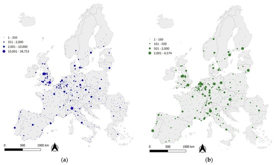
Figure 1.
Total number of observations in green areas (a) and forests (b) within cities. Cities without observations are not shown in the map.
Among cities with over 1000 total observations (174 cities), 26 cities shared more than 30% of observation in green areas, five of which with more than 40% (Kraków, Southampton, London, Madrid and Mons). Just nine of them had the highest percentage values of green areas as well, i.e., between 6.4% and 14%. Twelve other cities shared more than 30% of observations in forests, with three of them over 40% (Trondheim, Asti and Soest). Just three of them had the highest percentage values of forest area as well, i.e., between 42% and 62% (Heidelberg, Helsinki and Santiago de Compostela). The following spectrum chart (Figure 2) demonstrates this uneven attitude among green areas and forest observations within the same cities and between different cities.
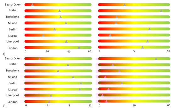
Figure 2.
Left side: spectrum charts showing relative values (%) of observations in green areas (a) and in forests (b); relative values were calculated as a percentage ratio between the total number of observations in the two types of green spaces and the total number of observations within the city. Right side: spectrum charts showing the relative values (%) of green areas (a) and in forests (b) for the respective cities; relative values were calculated as a percentage ratio between the areas of the two types of green spaces and the total area of the city. The charts refer to the first eight cities with the highest total observations.
Cities with less than 100 observations in green areas (32 cities) had less than 5% green areas; in contrast, cities with less than 100 observations in forests (37 cities) shared a forest area percentage up to 40%.
When grouping means of relative values of observations in green areas and forests (Figure 3) for each country, we noticed that eight countries (Estonia, Finland, Lithuania, Austria and Germany) were in the first twelve positions both for observations in green areas and in forests. Countries with more than 15% of observations in green areas (Figure 3a) were eight in number (including Luxemburg city, which is the only one in its country), with five of them also showing the highest proportion of mean green areas. Seven countries (e.g., Italy and France) had the lowest mean values of observations (i.e., less than 10%); just two of them also had the lowest mean proportion of green areas (Romania and Italy). Referring to forests (Figure 3b), ten countries had means over 15% (seven of them with the highest mean proportion of forest area as well), seven between 10% and 15% and ten between 5% and 10%. For some countries (e.g., Denmark for green areas and Lithuania for forests), the highest relative values of observations were not consistent with the corresponding highest values of green area or forest coverage within cities.
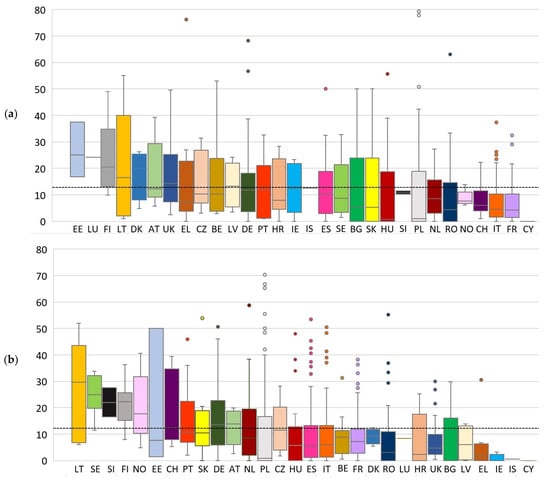
Figure 3.
Relative values (%) of observations in green areas (a) and forests (b). The black line indicates the European average. Relative values were calculated as a percentage ratio between the total number of observations in green areas (a) and forests (b) and the total number of observations within the city. The lines within box plots indicate the median value. The color is unique for each country so that it is possible to compare different values of observations for the same country respectively for green areas and forests. Full country name and related abbreviation as reported in the figure: Austria (AT); Belgium (BE); Bulgaria (BG); Croatia (HR); Cyprus (CY); Czech Republic (CZ); Denmark (DK); Estonia (EE); Finland (FI); France (FR); Germany (DE); Greece (EL); Hungary (HU); Iceland (IS); Ireland (IE); Italy (IT); Latvia (LV); Lithuania (LT); Luxembourg (LU); Netherlands (NL); Norway (NO); Poland (PL); Portugal (PT); Romania (RO); Slovakia (SK); Slovenia (SI); Spain (ES); Sweden (SE); Switzerland (CH); United Kingdom (UK).
3.2. Factors Influencing Access
The generalized mixed effects models helped to interpret the uneven attitudes of people in regard to the use of different types of urban nature, which were highlighted by the descriptive statistics. For urban green areas, city population was the strongest predictor, followed by the availability of green areas, GDP and city area (Table 3). For forests, accessibility was the strongest predictor, followed by GDP and city area. Unlike green areas, forest availability showed no significant relation with citizen observations. All predictors for forest observations were positively related.
Table 3.
Results of the Poisson generalized mixed effects model for the number of observations in green areas and forests in each city (N = 672). The factor “country” was also added to introduce an additional random effect. Significance of the models is reported. (*): p < 0.05; (**): p < 0.01; (***): p < 0.001. R2m and R2c stand for marginal and conditional R2s, respectively. Characters in italics indicate random effects. For green areas, fixed effects alone explain 63% of the variance; the variance explained increases to 75% when accounting for unmeasured effects related to country. For forests, fixed effects alone explain 62% of the variance; the variance explained increases to 73% when accounting for unmeasured effects related to country.
4. Discussion
In this study, we have analyzed data from iNaturalist to assess the use of nature by people in urban green spaces in Europe. It is the first attempt to quantify and compare the recreational use of both green areas and forests in European cities. A relatively large variability of observations was reported, with a relatively small number of cities having high numbers. Differences in the number of observations between green areas and forests were reported, and different factors had an influence on them.
4.1. The Use of iNaturalist to Detect the Use of Green Areas and Forests in European Cities
The use of a large database of citizen science data enables a continent-wide and multi-city analysis, which is usually not possible using the traditional sources of data and existing tools applied to assess the use of green areas and forests by citizens (e.g., interviews). This type of information is of extreme importance for local decision-makers, planners and managers of urban areas to meet the needs and demands of urban dwellers.
The use of green areas and forests in Europe is heterogeneous. The results showed that the level of use, as identified by this study, varied between cities both for green areas and forests, considered separately. A small portion of European cities had high reports of use, whereas low values were more common among cities. A number of cities that are well known for valuing green spaces were among those with highest reports of use, such as Barcelona, London and Lisbon.
Looking at total observations, green areas seemed to receive greater attention than forests. These spaces are usually within or nearer to residential settlements and city centers than forests, are more likely to be equipped and perceived as safe and are therefore more attractive to the general public.
In general, Baltic, Central European and United Kingdom cities seemed to have a higher reported use of green areas, whereas a more marked prominence towards urban forests was evident in Scandinavian countries. On the contrary, a number of Mediterranean and South-Eastern countries (e.g., Italy, France and Romania) exhibited a low share of observations in green areas and/or forests. In these cases, the different share of the two green infrastructure types may be the primary factors in such different results.
4.2. What Influences the Use of Green Areas and Forests in European Cities?
Interestingly, this study has shown that factors influencing the use of green areas and forests by people connected to nature are not fully consistent. Therefore, these results can support the specific planning and management of these two components of green infrastructure [69]. However, other variables not considered in this study, such as the presence of facilities, the number of species or the proportion of specific public or private green area types over the city, could play an important role in the selection and use of green spaces. Some of these data may not be available for several of the urban areas considered or with the spatial detail required in this study. Indeed, the preference for green spaces and forests within single cities is dependent on the specific characteristics of these areas and the reasons for visiting these spaces. For example, crowdedness was found to be positively crucial when seeking safe urban parks but had a negative impact for users looking for stress relief [70].
The gross domestic product of cities was positively related to the number of observations, indicating a possible link with the use of green areas and forests. Richer cities may indicate a higher availability of the technology (i.e., smartphones) necessary to use the iNaturalist application and a more suitable cultural background for scientific volunteering activities. Indeed, economic wealth has been highlighted as an important factor in visiting and benefiting from the various ecosystem services of green spaces at different scales [71]. This result is consistent with the concept that wealthier cities have higher land-use efficiency [47]. However, urban natural capital should be socially equitable, providing free and secure access to everyone, avoiding unfair distributions that benefit citizens between and among European cities and countries [72].
The population of cities was important only for green areas and not for forest use. This may have two main reasons. The use of green areas is connected to the number of potential users in probabilistic terms. In addition, however, forests, being more commonly found on the outskirts of cities, will be most likely used by citizens not living in that city but coming from neighboring areas. The areas of cities had contrasting roles in relation to the use of the two types of green spaces. Again, this could be explained by the different locations of green areas and forests, the former in central areas of the cities and the latter closer to the outskirts. In smaller cities, the link with neighboring green areas becomes evident, whereas larger cities often encompass urban forests, increasing the possible use of this landscape element.
Green space availability is a commonly used indicator to assess cities’ policies. It greatly varies between European cities and has been reported as a crucial indicator of the complex social-ecological interactions within cities [73]. The use of this indicator has been criticized when compared to accessibility, which gives a more suitable indication of potential use. However, it was shown that one condition of success in planning and managing urban green areas is the share of green space in cities, i.e., the green space availability [74]. Studies have shown that a low availability of green spaces is common with high population densities and that turning points of residential densities exist in the supply of green spaces [74,75]. Hence, in cities with high densities, green area availability is crucial for higher visitations.
Accessibility is important for forest visitation. First, this can be linked to a higher presence of forests in cities’ outskirts and fringes—city forests are mostly peri-urban forests. The configuration of urban landscape structure helps to understand this finding. A recent study on the forests of European metropolitan areas has shown that, linked to city sprawl, forest area increases with the increasing size of discontinuous urban settlements and the size of forest patches are positively linked to the average patch size of discontinuous dense urban fabric [46]. Therefore, a higher discontinuous presence of humans should mean a higher share of people neighboring large forest patches, indicating that accessibility to these forests is fundamental for their use. In general, for Europe, a lack of access to green spaces in the rural–urban interface has been reported [76]; thus emphasizing the role of peri-urban forest accessibility in relation to the use of these spaces. Unreachable, fragmented and distant woodland patches provide limited access to cultural services.
4.3. Limitations and Further Research
We caution that our results may represent the use of iNaturalist per se when the number of observations is low. However, our analysis has the potential to express the use of green areas and forests, in particular when the number of observations is high, improving the representativeness of such data.
There are still theoretical, technical and ethical debates on the proper use of participatory data sources in the scientific process [77]. However, with adequate premises and critical thinking, citizen science can enable the compelling investigation of humans’ relationships with nature [53]. The reliability of citizen science data has been criticized. However, this is mostly in regard to species monitoring issues, relating to the minimum amount of data necessary to appropriately represent a community. However, it has been highlighted that urban areas generally have a higher frequency of observations [78,79]. Furthermore, if the investigation is focused on these locations, as in this study, which focused on urban areas with a high number of observations, such bias becomes negligible [80].
Indeed, one could argue that observations occurring in one green area or forest can derive from one single or a few enthusiastic users of the mobile app, with a consequent bias. This means that the number of observations, which are derived from single users or a small number of users, do not necessarily reflect visitation rates by citizens. The large number of observations and their large geographic extent reduces the importance of this issue. Furthermore, the use of generalized mixed effect models to understand the factors influencing the use of green areas and forests in European cities is considered to be robust with unbalanced data [81].
Nevertheless, the identity of single users should be considered in future studies to account for the bias brought about by participants with high frequency of observations and this possible bias could be overcome by integrating citizen science data from available geotagged social media data. Indeed, the identity of the observer could be used to aggregate observations and reduce, to some extent, problems linked to data interpretation. Finally, it is important to recall that data on spatial locations derived from crowdsourced biodiversity observations could have positional errors [82], but this seems to be less likely and important when focusing on well-defined patches, such as green spaces, and not on specific species locations.
5. Conclusions
We employed citizen science data to examine the relationships between different types of urban green infrastructure and populations from 672 European cities. This approach demonstrated that iNaturalist observations could be used for different purposes than those strictly related to biodiversity monitoring, in particular to provide concrete information on where people use and value both green areas and forests, and enabled a better understanding of the supply of recreational services.
A number of factors helped to explain the use of green areas and forests. The importance of gross domestic product is shared by the two landscape elements. It is also worth noting that availability and accessibility were crucial indicators for the use of green areas and forests, respectively. Decision-makers at the European and national levels should carefully consider the role of the different indicators to help in meeting the increasing recreational needs within urban planning [69]. Compared to urban green areas that are under relatively strong recreational pressure, urban forests are overlooked by citizens. Therefore, low-cost interventions may render small, isolated and fragmented urban forests more secure and hospitable, diluting the pressure on urban parks and public gardens.
Over a long period, this evidence-based method could provide improved opportunities to measure the “human connection to nature” on a systematic and large-scale basis and help in achieving city-related SDG targets (e.g., providing equal access to safe, inclusive and accessible green and public spaces) [83,84]. Further research may take advantage of other large-base participatory initiatives and similar unconventional data sources to deepen the socio-economic analysis of the observed variability.
Supplementary Materials
The following are available online at https://www.mdpi.com/article/10.3390/f12060779/s1, Table S1: Summary of cities’ data for: total area (ha), number of observations (no.), forest area (%), green area (%), observations in forests (no. and % of total observations), observations in green areas (no. and % of total observations). Figure S2: Cover (%) of urban green areas in the analyzed European cities, Figure S3: Cover (%) of forests in the analyzed European cities.
Author Contributions
Conceptualization, V.E.C., T.C., G.T. and T.S.; methodology, V.E.C., T.C., G.T., R.T. and T.S.; formal analysis, V.E.C., G.T. and R.T.; investigation, V.E.C.; writing—original draft preparation, V.E.C., T.C. and G.T.; writing—review and editing, all; visualization, V.E.C., T.C. and G.T.; supervision, T.S.; project administration, T.S. All authors have read and agreed to the published version of the manuscript.
Funding
V.E.C. was supported by a PhD grant funded by the Department of Land, Environment, Agriculture and Forestry of the University of Padova and supervised by T.S.
Institutional Review Board Statement
Not applicable.
Informed Consent Statement
Not applicable.
Data Availability Statement
Data was downloaded and is available from iNaturalist (https://www.inaturalist.org/observations/export).
Conflicts of Interest
The authors declare no conflict of interest.
References
- Benedict, M.A.; McMahon, E.T. Green infrastructure: Smart conservation for the 21st century. Renew. Resour. J. 2002, 20, 12–17. [Google Scholar]
- Pickett, S.T.A.; Cadenasso, M.L.; Grove, J.M.; Nilon, C.H.; Pouyat, R.V.; Zipperer, W.C.; Costanza, R. Urban ecological systems: Linking terrestrial ecological, physical, and socioeconomic components of metropolitan area. Annu. Rev. Ecol. Syst. 2001, 32, 127–157. [Google Scholar] [CrossRef]
- Alberti, M.; Marzluff, J.; Shulenberger, E.; Bradley, G.; Ryan, C.; Zumbrunnen, C. Integrating humans into ecosystems: Opportunities and challenges for urban ecology. BioScience 2003, 53, 1169–1179. [Google Scholar] [CrossRef]
- Turner, W.R.; Nakamura, T.; Dinetti, M. Global urbanization and the separation of humans from nature. BioScience 2004, 54, 585–590. [Google Scholar] [CrossRef]
- Andersson, E.; Barthel, S.; Borgström, S.; Colding, J.; Elmqvist, T.; Folke, C.; Gren, Å. Reconnecting cities to the biosphere: Stewardship of green infrastructure and urban ecosystem services. AMBIO 2014, 43, 445–453. [Google Scholar] [CrossRef] [PubMed]
- Colding, J.; Lundberg, J.; Folke, C. Incorporating green-area user groups in urban ecosystem management. AMBIO 2006, 35, 237–244. [Google Scholar] [CrossRef]
- Runhaar, H.A.C.; Driessen, P.P.J.; Soer, L. Scientific commons: Sustainable urban development and the challenge of policy integration: An assessment of planning tools for integrating spatial and environmental planning in the Netherlands. Environ. Plan. B Plan. Des. 2009, 36, 417–431. [Google Scholar] [CrossRef]
- Ernstson, H.; Barthel, S.; Andersson, E.; Borgström, S.T. Scale-crossing brokers and network governance of urban ecosystem services: The case of Stockholm, Sweden. Ecol. Soc. 2010, 15, 28. [Google Scholar] [CrossRef]
- Hegetschweiler, K.T.; Plum, C.; Fischer, C.; Brändli, U.B.; Ginzler, C.; Hunziker, M. Towards a comprehensive social and natural scientific forest-recreation monitoring instrument—A prototypical approach. Landsc. Urban Plan. 2017, 167, 84–97. [Google Scholar] [CrossRef]
- Zhu, J.; Lu, H.; Zheng, T.; Rong, Y.; Wang, C.; Zhang, W.; Yan, Y.; Tang, L. Vitality of urban parks and its influencing factors from the perspective of recreational service supply, demand, and spatial links. Int. J. Environ. Res. Public Health 2020, 17, 1615. [Google Scholar] [CrossRef] [PubMed]
- Balram, S.; Dragićević, S. Attitudes toward urban green spaces: Integrating questionnaire survey and collaborative GIS techniques to improve attitude measurements. Landsc. Urban Plan. 2005, 71, 147–162. [Google Scholar] [CrossRef]
- Tyrväinen, L.; Mäkinen, K.; Schipperijn, J. Tools for mapping social values of urban woodlands and other green areas. Landsc. Urban Plan. 2007, 79, 5–19. [Google Scholar] [CrossRef]
- Daniel, T.C.; Muhar, A.; Arnberger, A.; Aznar, O.; Boyd, J.W.; Chan, K.M.A.; Costanza, R.; Elmqvist, T.; Flint, C.G.; Gobster, P.H.; et al. Contributions of cultural services to the ecosystem services agenda. Proc. Natl. Acad. Sci. USA 2012, 109, 8812–8819. [Google Scholar] [CrossRef]
- Plieninger, T.; Dijks, S.; Oteros-Rozas, E.; Bieling, C. Assessing, mapping, and quantifying cultural ecosystem services at community level. Land Use Policy 2013, 33, 118–129. [Google Scholar] [CrossRef]
- Heikinheimo, V.; Tenkanen, H.; Bergroth, C.; Järv, O.; Hiippala, T.; Toivonen, T. Understanding the use of urban green spaces from user-generated geographic information. Landsc. Urban Plan. 2020, 201, 103845. [Google Scholar] [CrossRef]
- Cessford, G.; Cockburn, S.; Douglas, M. Developing new visitor counters and their applications for management. In Monitoring and Management of Visitor Flows in Recreational and Protected Areas; Arnberger, A., Brandenburg, C., Muhar, A., Eds.; Bodenkultur University: Vienna, Austria, 2002; pp. 14–20. [Google Scholar]
- Kobori, H.; Dickinson, J.L.; Washitani, I.; Sakurai, R.; Amano, T.; Komatsu, N.; Kitamura, W.; Takagawa, S.; Koyama, K.; Ogawara, T.; et al. Citizen science: A new approach to advance ecology, education, and conservation. Ecol. Res. 2016, 31, 1–19. [Google Scholar] [CrossRef]
- Calzada, I. (Smart) citizens from data providers to decision-makers? The case study of Barcelona. Sustainability 2018, 10, 3252. [Google Scholar] [CrossRef]
- Mueller, J.; Lu, H.; Chirkin, A.; Klein, B.; Schmitt, G. Citizen design science: A strategy for crowd-creative urban design. Cities 2018, 72, 181–188. [Google Scholar] [CrossRef]
- Parsons, J.; Lukyanenko, R.; Wiersma, Y. Easier citizen science is better. Nature 2011, 471, 37. [Google Scholar] [CrossRef] [PubMed]
- McKinley, D.C.; Miller-Rushing, A.J.; Ballard, H.L.; Bonney, R.; Brown, H.; Cook-Patton, S.C.; Evans, D.M.; Franch, R.A.; Parrish, J.K.; Phillips, T.B.; et al. Citizen science can improve conservation science, natural resource management, and environmental protection. Biol. Conserv. 2017, 208, 15–28. [Google Scholar] [CrossRef]
- Dickinson, J.L.; Zuckerberg, B.; Bonter, D.N. Citizen science as an ecological research tool: Challenges and benefits. Annu. Rev. Ecol. Evol. Syst. 2010, 41, 149–172. [Google Scholar] [CrossRef]
- Evans, C.; Abrams, E.; Reitsma, R.; Roux, K.; Salmonsen, L.; Marra, P.P. The neighborhood nestwatch program: Participant outcomes of a citizen-science ecological research project. Conserv. Biol. 2005, 19, 589–594. [Google Scholar] [CrossRef]
- Davies, L.; Fradera, R.; Riesch, H.; Lakeman-Fraser, P. Surveying the citizen science landscape: An exploration of the design, delivery and impact of citizen science through the lens of the Open Air Laboratories (OPAL) programme. BMC Ecol. 2016, 16, 17. [Google Scholar] [CrossRef] [PubMed]
- Hofmann, M.; Westermann, J.R.; Kowarik, I.; van der Meer, E. Perceptions of parks and urban derelict land by landscape planners and residents. Urban For. Urban Green. 2012, 11, 303–312. [Google Scholar] [CrossRef]
- Cooper, C.B.; Dickinson, J.; Phillips, T.; Bonney, R. Citizen science as a tool for conservation in residential ecosystems. Ecol. Soc. 2007, 12, 11. [Google Scholar] [CrossRef]
- Kakihara, M. Grasping a Global View of Smartphone Diffusion: An Analysis from a Global Smartphone Study. In Proceedings of the 2014 International Conference on Mobile Business, London, UK, 4–5 June 2014; p. 11. [Google Scholar]
- Kleinschroth, F.; Kowarik, I. COVID-19 crisis demonstrates the urgent need for urban greenspaces. Front. Ecol. Environ. 2020, 18, 318–319. [Google Scholar] [CrossRef] [PubMed]
- Poom, A.; Järv, O.; Zook, M.; Toivonen, T. COVID-19 is spatial: Ensuring that mobile Big Data is used for social good. Big Data Soc. 2020, 7, 2053951720952088. [Google Scholar] [CrossRef]
- Korpilo, S.; Virtanen, T.; Lehvävirta, S. Smartphone GPS tracking—Inexpensive and efficient data collection on recreational movement. Landsc. Urban Plan. 2017, 157, 608–617. [Google Scholar] [CrossRef]
- Monz, C.; Mitrovich, M.; D’Antonio, A.; Sisneros-Kidd, A. Using mobile device data to estimate visitation in parks and protected areas: An example from the nature reserve of Orange County, California. J. Park Recreat. Adm. 2019, 37, 92–109. [Google Scholar] [CrossRef]
- Norman, P.; Pickering, C.M.; Castley, G. What can volunteered geographic information tell us about the different ways mountain bikers, runners and walkers use urban reserves? Landsc. Urban Plan. 2019, 185, 180–190. [Google Scholar] [CrossRef]
- Toivonen, T.; Heikinheimo, V.; Fink, C.; Hausmann, A.; Hiippala, T.; Järv, O.; Tenkanen, H.; Di Minin, E. Social media data for conservation science: A methodological overview. Biol. Conserv. 2019, 233, 298–315. [Google Scholar] [CrossRef]
- Ilieva, R.T.; McPhearson, T. Social-media data for urban sustainability. Nat. Sustain. 2018, 1, 553–565. [Google Scholar] [CrossRef]
- Wood, S.A.; Guerry, A.D.; Silver, J.M.; Lacayo, M. Using social media to quantify nature-based tourism and recreation. Sci. Rep. 2013, 3, 1–7. [Google Scholar] [CrossRef]
- Guerrero, P.; Møller, M.S.; Olafsson, A.S.; Snizek, B. Revealing cultural ecosystem services through Instagram images: The potential of social media volunteered geographic information for urban green infrastructure planning and governance. Urban Plan. 2016, 1, 1–17. [Google Scholar] [CrossRef]
- Roberts, H.V. Using Twitter data in urban green space research. Appl. Geogr. 2017, 81, 13–20. [Google Scholar] [CrossRef]
- Hamstead, Z.A.; Fisher, D.; Ilieva, R.T.; Wood, S.A.; McPhearson, T.; Kremer, P. Geolocated social media as a rapid indicator of park visitation and equitable park access. Comput. Environ. Urban Syst. 2018, 72, 38–50. [Google Scholar] [CrossRef]
- Donahue, M.L.; Keeler, B.L.; Wood, S.A.; Fisher, D.M.; Hamstead, Z.A.; McPhearson, T. Using social media to understand drivers of urban park visitation in the Twin Cities, MN. Landsc. Urban Plan. 2018, 175, 1–10. [Google Scholar] [CrossRef]
- Zhang, S.; Zhou, W. Recreational visits to urban parks and factors affecting park visits: Evidence from geotagged social media data. Landsc. Urban Plan. 2018, 180, 27–35. [Google Scholar] [CrossRef]
- Song, X.P.; Richards, D.R.; He, P.; Tan, P.Y. Does geo-located social media reflect the visit frequency of urban parks? A city-wide analysis using the count and content of photographs. Landsc. Urban Plan. 2020, 203, 103908. [Google Scholar] [CrossRef]
- Tian, T.; Sun, L.; Peng, S.; Sun, F.; Che, Y. Understanding the process from perception to cultural ecosystem services assessment by comparing valuation methods. Urban For. Urban Green. 2021, 57, 126945. [Google Scholar] [CrossRef]
- Nugent, J. iNaturalist: Citizen science for 21st-century naturalists. Sci. Scope 2018, 41, 12. [Google Scholar] [CrossRef]
- Unger, S.; Rollins, M.; Tietz, A.; Dumais, H. iNaturalist as an engaging tool for identifying organisms in outdoor activities. J. Biol. Educ. 2020, 1–11. [Google Scholar] [CrossRef]
- Dijkstra, L.; Poelman, H.; Veneri, P. The EU-OECD Definition of a Functional Urban Area; OECD Regional Development Working Papers; OECD Publishing: Paris, France, 2019. [Google Scholar] [CrossRef]
- Salvati, L.; Ranalli, F.; Carlucci, M.; Ippolito, A.; Ferrara, A.; Corona, P. Forest and the city: A multivariate analysis of peri-urban forest land cover patterns in 283 European metropolitan areas. Ecol. Indic. 2017, 73, 369–377. [Google Scholar] [CrossRef]
- Masini, E.; Tomao, A.; Barbati, A.; Corona, P.; Serra, P.; Salvati, L. Urban growth, land-use efficiency and local socioeconomic context: A comparative analysis of 417 metropolitan regions in Europe. Environ. Manag. 2019, 63, 322–337. [Google Scholar] [CrossRef] [PubMed]
- EEA. Mapping Guide for a European Urban Atlas, Version 6.1. Copenhagen. 2018. Available online: https://land.copernicus.eu/local/urban-atlas/urban-atlas-2018?tab=metadata (accessed on 15 July 2020).
- Kabisch, N.; Selsam, P.; Kirsten, T.; Lausch, A.; Bumberger, J. A multi-sensor and multi-temporal remote sensing approach to detect land cover change dynamics in heterogeneous urban landscapes. Ecol. Indic. 2019, 99, 273–282. [Google Scholar] [CrossRef]
- Montero, E.; Van Wolvelaer, J.A.; Garzon, A. The European Urban Atlas. In Land Use and Land Cover Mapping in Europe: Practices & Trends; Manakos, I., Braun, M., Eds.; Remote Sensing and Digital Image Processing Series; Springer: New York, NY, USA, 2014; pp. 115–124. [Google Scholar]
- iNaturalist. Available online: http://www.inaturalist.org (accessed on 30 March 2020).
- Chandler, M.; See, L.; Copas, K.; Bonde, A.M.Z.; López, B.C.; Danielsen, F.; Legind, J.K.; Masinde, S.; Miller-Rushing, A.J.; Newman, G.; et al. Contribution of citizen science towards international biodiversity monitoring. Biol. Conserv. 2017, 213 Pt B, 280–294. [Google Scholar] [CrossRef]
- Hochmair, H.H.; Scheffrahn, R.H.; Basille, M.; Boone, M. Evaluating the data quality of iNaturalist termite records. PLoS ONE 2020, 15, e0226534. [Google Scholar] [CrossRef]
- Van Horn, G.; Mac Aodha, O.; Song, Y.; Cui, Y.; Sun, C.; Shepard, A.; Adam, H.; Perona, P.; Belongie, S. The inaturalist species classification and detection dataset. In Proceedings of the IEEE Conference on Computer Vision and Pattern Recognition, Salt Lake City, UT, USA, 18–23 June 2018; pp. 8769–8778. [Google Scholar]
- R Core Team. R: A Language and Environment for Statistical Computing; R Foundation for Statistical Computing: Vienna, Austria, 2020; Available online: https://www.R-project.org/ (accessed on 18 July 2020).
- Campagnaro, T.; Sitzia, T.; Cambria, V.E.; Semenzato, P. Indicators for the planning and management of urban green spaces: A focus on public areas in Padua, Italy. Sustainability 2019, 11, 7071. [Google Scholar] [CrossRef]
- Zepp, H.; Groß, L.; Inostroza, L. And the winner is? Comparing urban green space provision and accessibility in eight European metropolitan areas using a spatially explicit approach. Urban For. Urban Green. 2020, 49, 126603. [Google Scholar] [CrossRef]
- Van den Bosch, M.A.; Mudu, P.; Uscila, V.; Barrdahl, M.; Kulinkina, A.; Staatsen, B.; Swart, W.; Kruize, H.; Zurlyte, I.; Egorov, A.I. Development of an urban green space indicator and the public health rationale. Scand. J. Public Health 2016, 44, 159–167. [Google Scholar] [CrossRef] [PubMed]
- Heynen, N.C. The scalar production of injustice within the urban forest. Antipode 2003, 35, 980–998. [Google Scholar] [CrossRef]
- Danford, R.S.; Strohbach, M.W.; Ryan, R.; Nicolson, C.; Warren, P.S. What Does it take to Achieve Equitable Urban Tree Canopy Distribution? A Boston Case Study. Cities Environ. 2014, 7, 2. [Google Scholar]
- Lee, A.C.; Maheswaran, R. The health benefits of urban green spaces: A review of the evidence. J. Public Health 2011, 33, 212–222. [Google Scholar] [CrossRef] [PubMed]
- Eurostat. Statistics on European Cities. Cities (Urban Audit)-Database. 2015. Available online: http://ec.europa.eu/eurostat/web/cities/data/database (accessed on 20 February 2020).
- ESRI. ArcGIS Pro 2.4.0. Environmental Systems Research Institute. 2019. Available online: https://www.esri.com/en-us/arcgis/products/arcgis-pro/overview (accessed on 15 January 2020).
- QGIS Development Team. QGIS 3.4 LTR “Madeira”. QGIS Geographic Information System. Open Source Geospatial Foundation Project. 2020. Available online: https://www.qgis.org (accessed on 15 January 2020).
- Bates, D.; Maechler, M.; Bolker, B. Package ‘‘Lme4’’. 2012. Available online: http://cran.r-project.org/web/packages/lme4/lme4.pdf (accessed on 12 June 2020).
- Zuur, A.F.; Ieno, E.N.; Walker, N.J.; Saveliev, A.A.; Smith, G.M. Mixed Effects Modelling for Nested Data. In Mixed Effects Models and Extensions in Ecology with R. Statistics for Biology and Health; Springer: New York, NY, USA, 2009. [Google Scholar] [CrossRef]
- Harrison, X.A. Using observation-level random effects to model overdispersion in count data in ecology and evolution. PeerJ 2014, 2, e616. [Google Scholar] [CrossRef] [PubMed]
- Barton, K. MuMIn Version 1.15.6 Model Selection and Model Averaging Based on Information Criteria (AICc and Alike). 2016. Available online: https://cran.rproject.org/web/packages/MuMIn/MuMIn.pdf (accessed on 25 June 2020).
- Konijnendijk, C.C. A decade of urban forestry in Europe. For. Policy Econ. 2003, 5, 173–186. [Google Scholar] [CrossRef]
- Campagnaro, T.; Vecchiato, D.; Arnberger, A.; Celegato, R.; Da Re, R.; Rizzetto, R.; Semenzato, P.; Sitzia, T.; Tempesta, T.; Cattaneo, D. General, stress relief and perceived safety preferences for green spaces in the historic city of Padua (Italy). Urban For. Urban Green. 2020, 52, 126695. [Google Scholar] [CrossRef]
- Gosal, A.S.; Giannichi, M.L.; Beckmann, M.; Comber, A.; Massenberg, J.R.; Palliwoda, J.; Roddis, P.; Schägner, J.P.; Wilson, J.; Ziv, G. Do drivers of nature visitation vary spatially? The importance of context for understanding visitation of nature areas in Europe and North America. Sci. Total Environ. 2021, 776, 145190. [Google Scholar] [CrossRef]
- Rutt, R.L.; Gulsrud, N.M. Green justice in the city: A new agenda for urban green space research in Europe. Urban For. Urban Green. 2016, 19, 123–127. [Google Scholar] [CrossRef]
- Kabisch, N.; Strohbach, M.; Haase, D.; Kronenberg, J. Urban green space availability in European cities. Ecol. Indic. 2016, 70, 586–596. [Google Scholar] [CrossRef]
- Baycan-Levent, T.; Nijkamp, P. Planning and management of urban green spaces in Europe: Comparative analysis. J. Urban Plan. Dev. 2009, 135, 1–12. [Google Scholar] [CrossRef]
- Wolff, M.; Haase, D. Mediating sustainability and liveability—turning points of green space supply in European cities. Front. Environ. Sci. 2019, 7, 61. [Google Scholar] [CrossRef]
- Wolff, M.; Scheuer, S.; Haase, D. Looking beyond boundaries: Revisiting the rural-urban interface of Green Space Accessibility in Europe. Ecol. Indic. 2020, 113, 106245. [Google Scholar] [CrossRef]
- Jacobs, C.; Zipf, A. Completeness of citizen science biodiversity data from a volunteered geographic information perspective. Geo-Spat. Inf. Sci. 2017, 20, 3–13. [Google Scholar] [CrossRef]
- Kelling, S.; Fink, D.; La Sorte, F.A.; Johnston, A.; Bruns, N.E.; Hochachka, W.M. Taking a ‘Big Data’ approach to data quality in a citizen science project. AMBIO 2015, 44, 601–611. [Google Scholar] [CrossRef]
- Callaghan, C.T.; Major, R.E.; Lyons, M.B.; Martin, J.M.; Wilshire, J.H.; Kingsford, R.T.; Cornwell, W.K. Using citizen science data to define and track restoration targets in urban areas. J. Appl. Ecol. 2019, 56, 1998–2006. [Google Scholar] [CrossRef]
- Callaghan, C.T.; Gawlik, D.E. Efficacy of eBird data as an aid in conservation planning and monitoring. J. Field Ornithol. 2015, 86, 298–304. [Google Scholar] [CrossRef]
- Schielzeth, H.; Dingemanse, N.J.; Nakagawa, S.; Westneat, D.F.; Allegue, H.; Teplitsky, C.; Réale, D.; Dochtermann, N.A.; Garamszegi, L.Z.; Araya-Ajoy, Y.G. Robustness of linear mixed-effects models to violations of distributional assumptions. Methods Ecol. Evol. 2020, 11, 1141–1152. [Google Scholar] [CrossRef]
- Vahidi, H.; Klinkenberg, B.; Yan, W. Trust as a proxy indicator for intrinsic quality of Volunteered Geographic Information in biodiversity monitoring programs. GISci. Remote Sens. 2018, 55, 502–538. [Google Scholar] [CrossRef]
- Fraisl, D.; Campbell, J.; See, L.; Wehn, U.; Wardlaw, J.; Gold, M.; Moorthy, I.; Arias, R.; Piera, J.; Oliver, J.L.; et al. Mapping citizen science contributions to the UN sustainable development goals. Sustain. Sci. 2020, 15, 1735–1751. [Google Scholar] [CrossRef]
- Fritz, S.; See, L.; Carlson, T.; Haklay, M.M.; Oliver, J.L.; Fraisl, D.; Mondardini, R.; Shanley, L.A.; Schade, S.; Wehn, U.; et al. Citizen science and the United Nations sustainable development goals. Nat. Sustain. 2019, 2, 922–930. [Google Scholar] [CrossRef]
Publisher’s Note: MDPI stays neutral with regard to jurisdictional claims in published maps and institutional affiliations. |
© 2021 by the authors. Licensee MDPI, Basel, Switzerland. This article is an open access article distributed under the terms and conditions of the Creative Commons Attribution (CC BY) license (https://creativecommons.org/licenses/by/4.0/).