Forest Burned Area Detection Using a Novel Spectral Index Based on Multi-Objective Optimization
Abstract
:1. Introduction
2. Materials and Methods
2.1. Data and Study Area
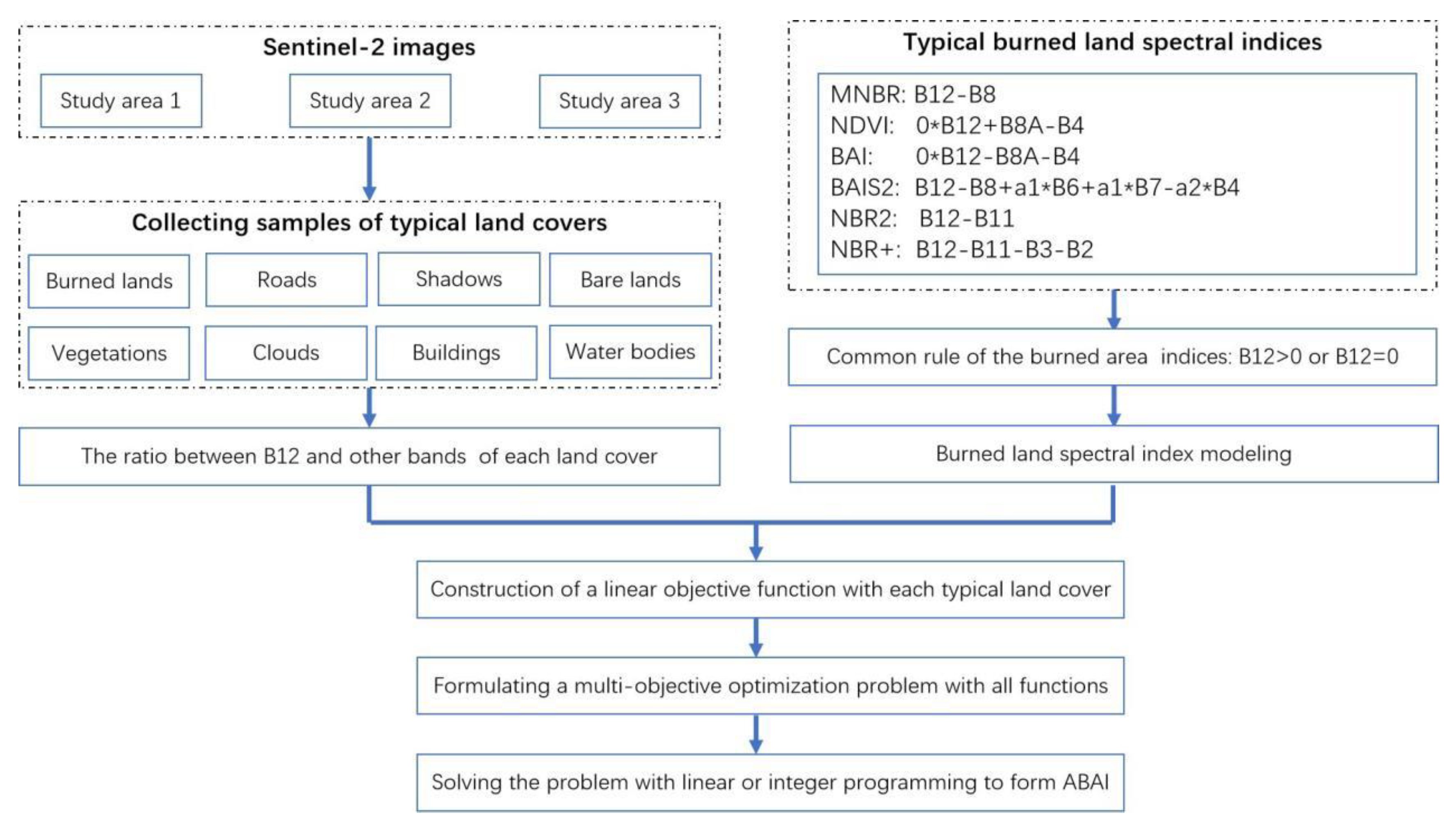
2.2. Methodology
2.2.1. Some Existing Spectral Indices
| Indices | References | Formulations |
|---|---|---|
| Modified Normalized Burn Ratio (MNBR) | [19] | |
| NDVI | [31] | |
| Burned Area Index (BAI) | [20] | |
| Burned Area Index for Sentinel-2 (BAIS2) | [29] | |
| Normalized Burn Ratio 2 (NBR2) | [30] | |
| Normalized Burn Ratio Plus (NBR+) | [21] | |
| Mid-Infrared Bispectral Index (MIRBI) | [28] | 2 |
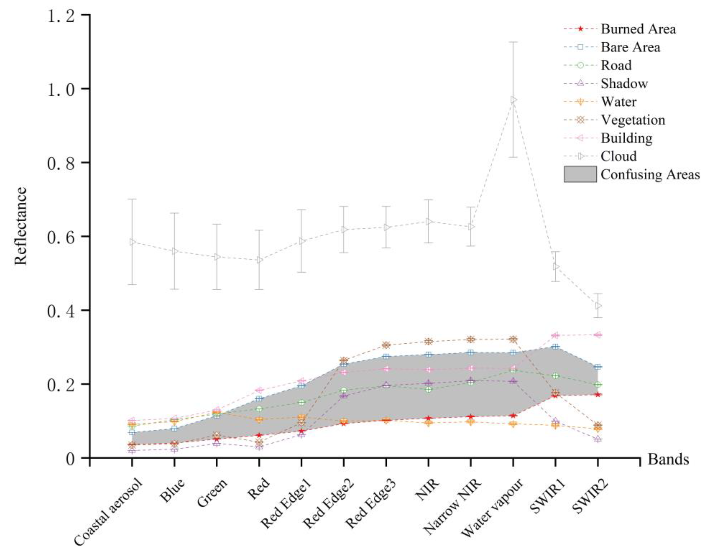
2.2.2. Reflectance Analysis
2.2.3. Development of the ABAI Index
2.3. Accuracy Assessment Measures
3. Results and Analysis
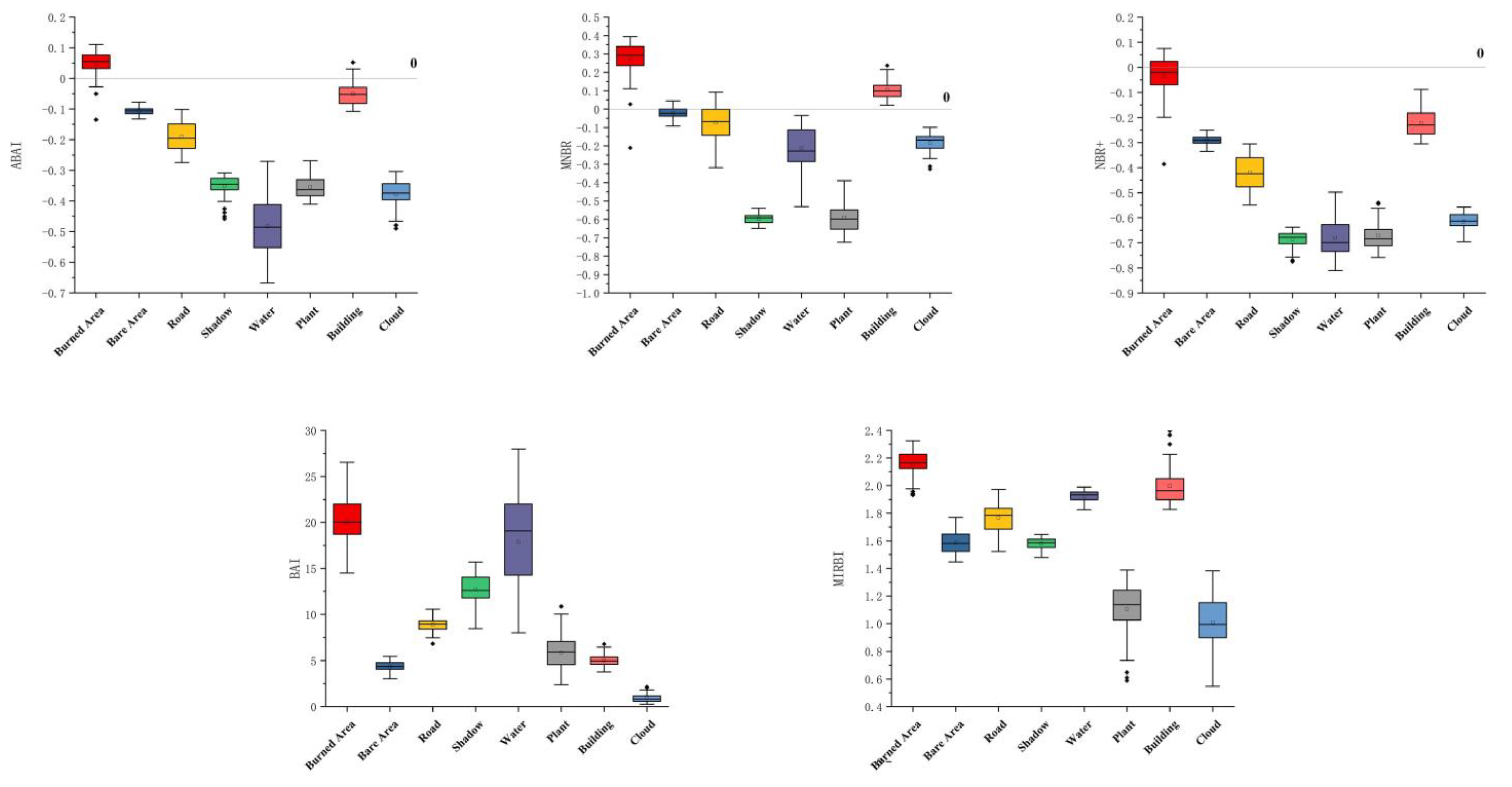
3.1. Comparison and Explanation of the ABAI
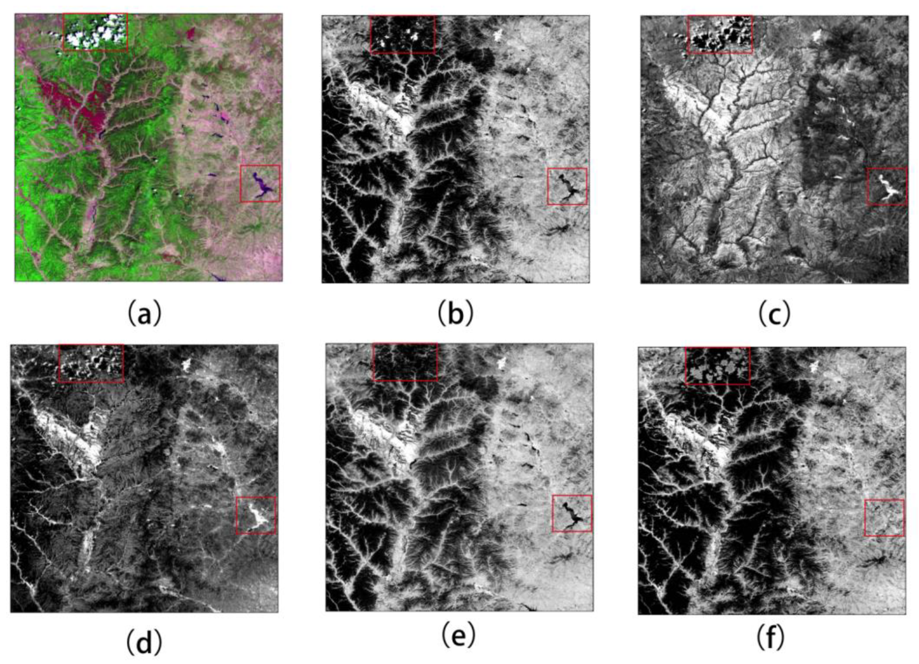
3.2. Visual Evaluation of the Indices
3.3. Quantitative Evaluation of the Indices
4. Discussion
5. Conclusions
Author Contributions
Funding
Acknowledgments
Conflicts of Interest
References
- Goldammer, J.G.; Statheropoulos, M.; Andreae, M.O. Impacts of vegetation fire emissions on the environment, human health, and security: A global perspective. In Developments in Environmental Science; Bytnerowicz, A., Arbaugh, M.J., Riebau, A.R., Andersen, C., Eds.; Elsevier: Amsterdam, The Netherlands, 2008; Volume 8, pp. 3–36. [Google Scholar]
- Giglio, L.; Randerson, J.T.; van der Werf, G.R.; Kasibhatla, P.S.; Collatz, G.J.; Morton, D.C.; DeFries, R.S. Assessing variability and long-term trends in burned area by merging multiple satellite fire products. Biogeosci. Discuss. 2009, 6, 11577–11622. [Google Scholar] [CrossRef] [Green Version]
- Bowman, D.M.J.S.; Balch, J.K.; Artaxo, P.; Bond, W.J.; Carlson, J.M.; Cochrane, M.A.; D’Antonio, C.M.; DeFries, R.S.; Doyle, J.C.; Harrison, S.P.; et al. Fire in the Earth System. Science 2009, 324, 481–484. [Google Scholar] [CrossRef] [PubMed]
- Meng, R.; Dennison, P.E.; Huang, C.; Moritz, M.A.; D’Antonio, C. Effects of fire severity and postfire climate on short-term vegetation recovery of mixed-conifer and red fir forests in the Sierra Nevada Mountains of California. Remote Sens. Environ. 2015, 171, 311–325. [Google Scholar] [CrossRef]
- Randerson, J.T.; Chen, Y.; van der Werf, G.R.; Rogers, B.M.; Morton, D.C. Global burned area and biomass burning emissions from small fires. J. Geophys. Res.-Biogeosci. 2012, 117, G4. [Google Scholar] [CrossRef] [Green Version]
- Keane, R.E.; Cary, G.J.; Parsons, R. Using simulation to map fire regimes: An evaluation of approaches, strategies, and limitations. Int. J. Wildland Fire 2003, 12, 309–322. [Google Scholar] [CrossRef]
- Westerling, A.L.; Hidalgo, H.G.; Cayan, D.R.; Swetnam, T.W. Warming and Earlier Spring Increase Western U.S. Forest Wildfire Activity. Science 2006, 313, 940–943. [Google Scholar] [CrossRef] [PubMed] [Green Version]
- Zhang, Q.; Ge, L.; Zhang, R.; Metternicht, G.I.; Du, Z.; Kuang, J.; Xu, M. Deep-learning-based burned area mapping using the synergy of Sentinel-1&2 data. Remote Sens. Environ. 2021, 264, 112575. [Google Scholar]
- Thompson, M.P.; MacGregor, D.G.; Dunn, C.J.; Calkin, D.E.; Phipps, J. Rethinking the wildland fire management system. J. For. 2018, 116, 382–390. [Google Scholar] [CrossRef] [Green Version]
- Tariq, A.; Shu, H.; Gagnon, A.S.; Li, Q.; Mumtaz, F.; Hysa, A.; Siddique, M.A.; Munir, I. Assessing burned areas in wildfires and prescribed fires with spectral indices and SAR images in the Margalla Hills of Pakistan. Forests 2021, 12, 1371. [Google Scholar] [CrossRef]
- Roy, D.P.; Boschetti, L.; Justice, C.O.; Ju, J. The collection 5 MODIS burned area product—Global evaluation by comparison with the MODIS active fire product. Remote Sens. Environ. 2008, 112, 3690–3707. [Google Scholar] [CrossRef]
- Kasischke, E.S.; Bourgeau-Chavez, L.L.; French, N.H.F. Observations of variations in ERS-1 SAR image intensity associated with forest fires in Alaska. IEEE Trans. Geosci. Remote Sens. 1994, 32, 206–210. [Google Scholar] [CrossRef]
- Flannigan, M.D.; Vonder Haar, T.H. Forest fire monitoring using NOAA satellite AVHRR. Can. J. For. Res 1986, 16, 975–982. [Google Scholar] [CrossRef]
- Chuvieco, E.; Matrin, M.P. A simple method for fire growth mapping using AVHRR channel 3 data. Int. J. Remote Sens. 1994, 15, 3141–3146. [Google Scholar] [CrossRef]
- Fuller, D.O.; Fulk, M. Burned area in Kalimantan, Indonesia mapped with NOAA-AVHRR and Landsat TM imagery. Int. J. Remote Sens. 2001, 22, 691–697. [Google Scholar] [CrossRef]
- Petropoulos, G.P.; Kontoes, C.; Keramitsoglou, I. Burnt area delineation from a uni-temporal perspective based on Landsat TM imagery classification using Support Vector Machines. Int. J. Appl. Earth Obs. Geoinf. 2011, 13, 70–80. [Google Scholar] [CrossRef]
- Ramo, R.; Chuvieco, E. Developing a random forest algorithm for MODIS global burned area classification. Remote Sens. 2017, 9, 1193. [Google Scholar] [CrossRef] [Green Version]
- Brand, A.; Manandhar, A. Semantic Segmentation of Burned Areas in Satellite Images Using a U-Net Convolutional Neural Network. ISPRS-Int. Arch. Photogramm. Remote Sens. Spat. Inf. Sci. 2021, 43, 47–53. [Google Scholar] [CrossRef]
- García, M.J.L.; Caselles, V. Mapping burns and natural reforestation using thematic mapper data. Geocarto Int. 1991, 6, 31–37. [Google Scholar] [CrossRef]
- Chuvieco, E.; Martin, M.P.; Palacios, A. Assessment of different spectral indices in the red-near-infrared spectral domain for burned land discrimination. Int. J. Remote Sens. 2002, 23, 5103–5110. [Google Scholar] [CrossRef]
- Alcaras, E.; Costantino, D.; Guastaferro, F.; Parente, C.; Pepe, M. Normalized Burn Ratio Plus (NBR+): A new index for Sentinel-2 imagery. Remote Sens. 2022, 14, 1727. [Google Scholar] [CrossRef]
- Smiraglia, D.; Filipponi, F.; Mandrone, S.; Tornato, A.; Taramelli, A. Agreement index for burned area mapping: Integration of multiple spectral indices using Sentinel-2 satellite images. Remote Sens. 2020, 12, 1862. [Google Scholar] [CrossRef]
- Stroppiana, D.; Bordogna, G.; Carrara, P.; Boschetti, M.; Boschetti, L.; Brivio, P.A. A method for extracting burned areas from Landsat TM/ETM+ images by soft aggregation of multiple Spectral Indices and a region growing algorithm. ISPRS J. Photogramm. Remote Sens. 2012, 69, 88–102. [Google Scholar] [CrossRef]
- Loboda, T.; O’Neal, K.J.; Csiszar, I. Regionally adaptable dNBR-based algorithm for burned area mapping from MODIS data. Remote Sens. Environ. 2007, 109, 429–442. [Google Scholar] [CrossRef]
- Schepers, L.; Haest, B.; Veraverbeke, S.; Spanhove, T.; Borre, J.V.; Goossens, R. Burned area detection and burn severity assessment of a heathland fire in Belgium using airborne imaging spectroscopy (APEX). Remote Sens. 2014, 6, 1803–1826. [Google Scholar] [CrossRef] [Green Version]
- Zhang, X.; Liu, L.; Wu, C.; Chen, X.; Gao, Y.; Xie, S.; Zhang, B. Development of a global 30m impervious surface map using multisource and multitemporal remote sensing datasets with the Google Earth Engine platform. Earth Syst. Sci. Data 2020, 12, 1625–1648. [Google Scholar] [CrossRef]
- Chuvieco, E.; Congalton, R.G. Mapping and inventory of forest fires from digital processing of TM data. Geocarto Int. 1998, 4, 41–53. [Google Scholar] [CrossRef]
- Trigg, S.; Flasse, S. An evaluation of different bi-spectral spaces for discriminating burned shrub savanna. Int. J. Remote Sens. 2001, 22, 2641–2647. [Google Scholar] [CrossRef]
- Filipponi, F. BAIS2: Burned area index for Sentinel-2. Multidiscip. Digit. Publ. Inst. Proc. 2018, 2, 364. [Google Scholar]
- Storey, E.A.; Stow, D.A.; O’Leary, J.F. Assessing postfire recovery of chamise chaparral using multi-temporal spectral vegetation index trajectories derived from Landsat imagery. Remote Sens. Environ. 2016, 183, 53–64. [Google Scholar] [CrossRef] [Green Version]
- Rouse, J.W.; Haas, R.H.; Schell, J.A.; Deering, D.W. Monitoring vegetation systems in the Great Plains with ERTS. In Proceedings of the Third ERTS Symposium, Washington, DC, USA, 10–14 December 1973; Freden, S.C., Becker, M., Eds.; NASA SP-351; National Aeronautics and Space Administration: Washington, DC, USA, 1973. [Google Scholar]
- Liu, Z.; Li, G. Efficient regularized regression with L0 penalty for variable selection and network construction. Comput. Math. Methods Med. 2016, 2016, 3456153. [Google Scholar] [CrossRef] [Green Version]
- Geoffrion, A.M.; Marsten, R. Integer programming algorithms: A framework and state-of-the-art survey. Manag. Sci. 1972, 18, 465–491. [Google Scholar] [CrossRef]
- Westerberg, C.H.; Bjorklund, B.; Hultman, E. An application of mixed integer programming in a swedish steel mill. Interfaces 1977, 7, 39–43. [Google Scholar] [CrossRef]
- Cornuéjols, G. Valid inequalities for mixed integer linear programs. Math. Program. 2008, 112, 3–44. [Google Scholar] [CrossRef] [Green Version]
- Nemhauser, G.L.; Wolsey, L.A. Integer and Combinatorial Optimization; Wiley-Interscience: New York, NY, USA, 1999. [Google Scholar]
- Ip, F.; Dohm, J.M.; Baker, V.R.; Doggett, T.; Davies, A.G.; Castano, B.; Cichy, B.; Greeley, R.; Sherwood, R. ASE floodwater classifier development for EO-1hyperion imagery. Lunar Planet. Sci. 2004, 35, 1–2. [Google Scholar]
- Sanchez, A.H.; Picoli, M.C.A.; Camara, G.; Andrade, P.R.; Chaves, M.E.D.; Lechler, S.; Queiroz, G.R. Comparison of cloud cover detection algorithms on sentinel–2 images of the amazon tropical forest. Remote Sens. 2020, 12, 1284. [Google Scholar] [CrossRef] [Green Version]
- Sciandrello, S.; D’Agostino, S.; Minissale, P. Vegetation analysis of the Taormina Region in Sicily: A plant landscape characterized by geomorphology variability and both ancient and recent anthropogenic influences. Lazaroa 2013, 34, 151. [Google Scholar] [CrossRef] [Green Version]
- A Report on ‘3.30’ Forest Fire in Xichang City, Liangshan Prefecture. Available online: http://scdfz.sc.gov.cn/whzh/slzc1/content_49723 (accessed on 5 September 2022). (In Chinese)
- Tversky, A.; Kahneman, D. Advances in prospect theory: Cumulative representation of uncertainty. J. Risk Uncertain. 1992, 5, 297–323. [Google Scholar] [CrossRef]
- Bastarrika, A.; Chuvieco, E.; Pilar Martín, M. Mapping burned areas from Landsat TM/ETM + data with a two-phase algorithm: Balancing omission and commission errors. Remote Sens. Environ. 2011, 115, 1003–1012. [Google Scholar] [CrossRef]
- Abdikan, S.; Bayik, C.; Sekertekin, A.; Bektas Balcik, F.; Karimzadeh, S.; Matsuoka, M.; Balik Sanli, F. Burned area detection using multi-sensor SAR, optical, and thermal data in Mediterranean pine forest. Forests 2022, 13, 347. [Google Scholar] [CrossRef]
- Mats, R.; Sander, V. How much of a pixel needs to burn to be detected by satellites? A spectral modeling experiment based on ecosystem data from Yellowstone National Park, USA. Remote Sens. 2022, 14, 2075. [Google Scholar]
- Hislop, S.; Jones, S.; Soto-Berelov, M.; Skidmore, A.; Haywood, A.; Nguyen, T.H. Using Landsat spectral indices in time-series to assess wildfire disturbance and recovery. Remote Sens. 2018, 10, 460. [Google Scholar] [CrossRef] [Green Version]
- Mashhadi, N.; Alganci, U. Determination of forest burn scar and burn severity from free satellite images: A comparative evaluation of spectral indices and machine learning classifiers. Int. J. Environ. Geoinform. 2021, 8, 488–497. [Google Scholar] [CrossRef]
- Itziar, A.-C.; Emilio, C. Global burned area mapping from ENVISAT-MERIS and MODIS active fire data. Remote Sens. Environ. 2015, 163, 140–152. [Google Scholar]
- Fernández-Manso, A.; Fernández-Manso, O.; Quintano, C. SENTINEL-2A red-edge spectral indices suitability for discriminating burn severity. Int. J. Appl. Earth Obs. Geoinf. 2016, 50, 170–175. [Google Scholar] [CrossRef]
- Veraverbeke, S.; Lhermitte, S.; Verstraeten, W.W.; Goossens, R. Evaluation of pre/post-fifire differenced spectral indices for assessing burn severity in a Mediterranean environment with Landsat Thematic Mapper. Int. J. Remote Sens. 2011, 32, 3521–3537. [Google Scholar] [CrossRef]
- Mallinis, G.; Mitsopoulos, I.; Chrysafifi, I. Evaluating and comparing sentinel 2A and landsat-8 operational land imager (OLI) spectral indices for estimating fire severity in a Mediterranean pine ecosystem of Greece. GISci. Remote Sens. 2018, 55, 1–18. [Google Scholar] [CrossRef]



| Bands | S2A Central Wavelength (nm) | S2B Central Wavelength (nm) | Resolution (m) |
|---|---|---|---|
| B1-Coastal Aerosol | 442.7 | 442.2 | 60 |
| B2-Blue | 492.4 | 492.1 | 10 |
| B3-Green | 559.8 | 559.0 | 10 |
| B4-Red | 664.6 | 664.9 | 10 |
| B5-Red Edge1 | 704.1 | 703.8 | 20 |
| B6- Red Edge2 | 740.5 | 739.1 | 20 |
| B7- Red Edge3 | 782.8 | 779.7 | 20 |
| B8-NIR | 832.8 | 832.9 | 10 |
| B8A-Narrow NIR | 864.7 | 864.0 | 20 |
| B9-Water Vapor | 945.1 | 943.2 | 60 |
| B10-SWIR Cirrus | 1373.5 | 1376.9 | 60 |
| B11-SWIR1 | 1613.7 | 1610.4 | 20 |
| B12-SWIR2 | 2202.4 | 2185.7 | 20 |
| Study Case | Sensor | Orbit | Acquisition Date |
|---|---|---|---|
| Qinyuan | Sentinel-2B | R118 | 10-06-2018 |
| Sentinel-2A | R118 | 10-06-2019 | |
| Xichang City | Sentinel-2B | R104 | 30-03-2020 |
| Sentinel-2B | R104 | 09-04-2020 | |
| Sicily Island | Sentinel-2A | R036 | 24-07-2019 |
| Sentinel-2A | R036 | 23-08-2019 |
| Bi/SWIR2 | Burned Land | Bare Land | Shadow | Water | Buildings |
| Q1 | 0.23 | 0.32 | 0.46 | 0.43 | 0.32 |
| Q2 | 0.30 | 0.46 | 0.77 | 0.69 | 0.39 |
| Q3 | 0.36 | 0.65 | 0.60 | 0.48 | 0.55 |
| Q4 | 0.54 | 1.03 | 3.29 | 2.97 | 0.69 |
| Q5 | 0.59 | 1.11 | 3.86 | 3.44 | 0.72 |
| Q6 | 0.63 | 1.14 | 3.96 | 3.54 | 0.72 |
| Q7 | 0.65 | 1.16 | 4.10 | 3.61 | 0.73 |
| Q8 | 0.98 | 1.22 | 1.95 | 1.99 | 0.99 |
| Q9 | 1 | 1 | 1 | 1 | 1 |
| Study Cases | Method | PA-BA | PA-Non BA | UA-BA | UA-Non BA | OA | KAPPA |
|---|---|---|---|---|---|---|---|
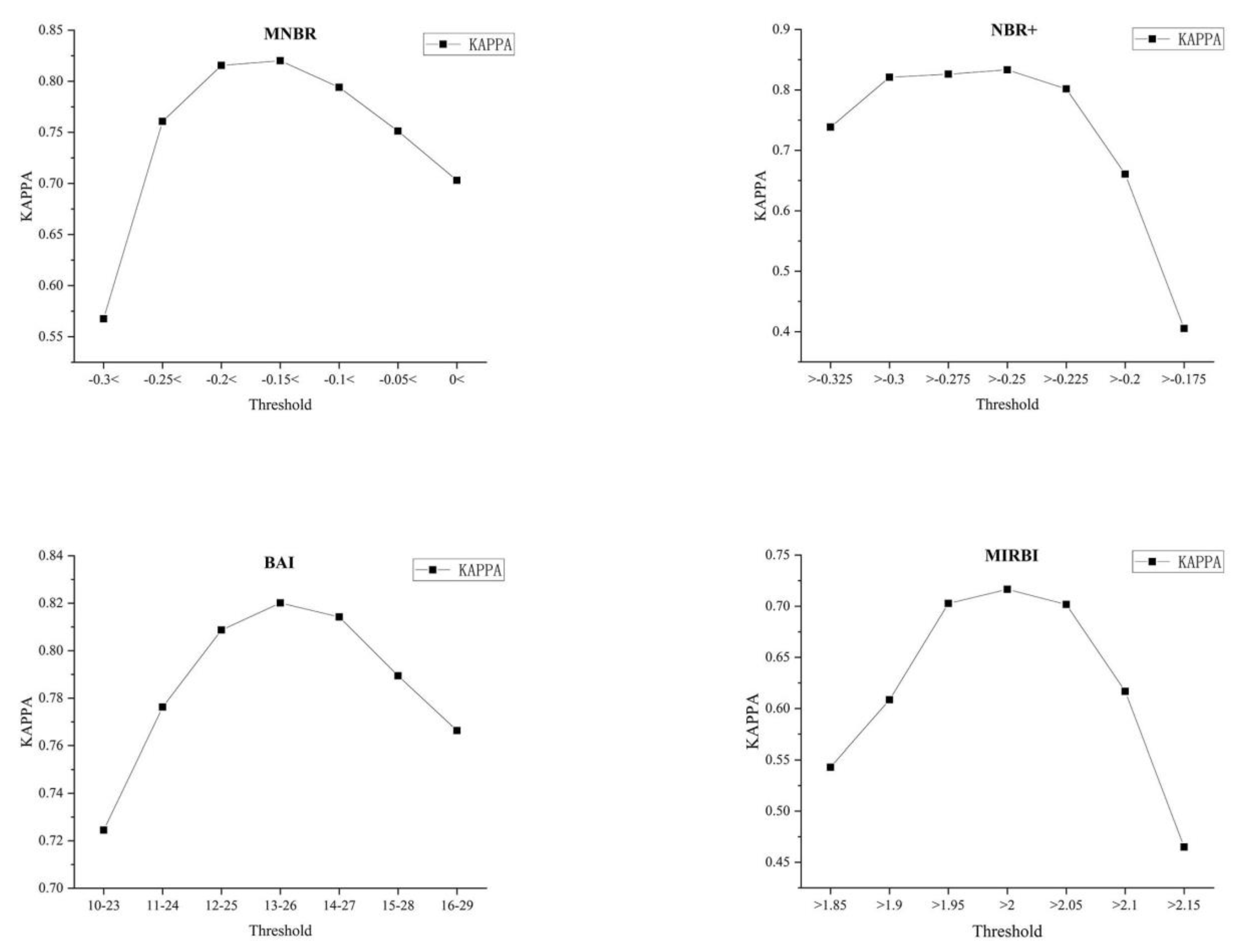
| MNBR | 0.878 | 0.940 | 0.930 | 0.895 | 0.910 | 0.820 | |
| NBR+ | 0.866 | 0.964 | 0.956 | 0.888 | 0.917 | 0.833 | |
| Qinyuan | BAI | 0.994 | 0.833 | 0.844 | 0.994 | 0.910 | 0.820 |
| MIRBI | 0.814 | 0.900 | 0.881 | 0.842 | 0.859 | 0.717 | |
| ABAI | 0.848 | 0.982 | 0.977 | 0.877 | 0.918 | 0.835 | |
| MNBR | 0.847 | 0.905 | 0.779 | 0.937 | 0.888 | 0.732 | |
| NBR+ | 0.800 | 0.844 | 0.670 | 0.914 | 0.831 | 0.608 | |
| Xichang | BAI | 0.413 | 0.976 | 0.873 | 0.807 | 0.816 | 0.463 |
| MIRBI | 0.867 | 0.913 | 0.798 | 0.945 | 0.899 | 0.759 | |
| ABAI | 0.833 | 0.931 | 0.828 | 0.934 | 0.903 | 0.763 | |
| MNBR | 0.951 | 0.891 | 0.503 | 0.994 | 0.897 | 0.604 | |
| NBR+ | 0.614 | 0.992 | 0.899 | 0.957 | 0.953 | 0.705 | |
| Sicily | BAI | 0.705 | 0.984 | 0.785 | 0.945 | 0.934 | 0.680 |
| MIRBI | 0.821 | 0.882 | 0.755 | 0.918 | 0.936 | 0.686 | |
| ABAI | 0.782 | 0.995 | 0.952 | 0.975 | 0.973 | 0.844 |
Publisher’s Note: MDPI stays neutral with regard to jurisdictional claims in published maps and institutional affiliations. |
© 2022 by the authors. Licensee MDPI, Basel, Switzerland. This article is an open access article distributed under the terms and conditions of the Creative Commons Attribution (CC BY) license (https://creativecommons.org/licenses/by/4.0/).
Share and Cite
Wu, B.; Zheng, H.; Xu, Z.; Wu, Z.; Zhao, Y. Forest Burned Area Detection Using a Novel Spectral Index Based on Multi-Objective Optimization. Forests 2022, 13, 1787. https://doi.org/10.3390/f13111787
Wu B, Zheng H, Xu Z, Wu Z, Zhao Y. Forest Burned Area Detection Using a Novel Spectral Index Based on Multi-Objective Optimization. Forests. 2022; 13(11):1787. https://doi.org/10.3390/f13111787
Chicago/Turabian StyleWu, Bo, He Zheng, Zelong Xu, Zhiwei Wu, and Yindi Zhao. 2022. "Forest Burned Area Detection Using a Novel Spectral Index Based on Multi-Objective Optimization" Forests 13, no. 11: 1787. https://doi.org/10.3390/f13111787
APA StyleWu, B., Zheng, H., Xu, Z., Wu, Z., & Zhao, Y. (2022). Forest Burned Area Detection Using a Novel Spectral Index Based on Multi-Objective Optimization. Forests, 13(11), 1787. https://doi.org/10.3390/f13111787


