Abstract
Prunus tomentosa (Thunb.) Wall has high nutritional value and medicinal effects. It is widespread in China; however, most plants growing in the wild are near extinction in many places. Predicting the potential distribution of P. tomentosa under climate change is helpful for cultivating and protecting wild germplasm resources. We used two general circulation models (CCSM4 and MIROC-ESM) and two future climate scenarios (RCP4.5 and RCP8.5) to predict P. tomentosa’s present and future geographical distribution. A total of 137 distribution data points and 19 bioclimatic variables were imported into the maximum entropy model (MaxEnt). The optimal parameter combination (feature class LQHPT, regularized multiplier 3.0) was selected with corrected Akaike Information Criterion as the index. The results showed that at present and in the future, P. tomentosa was distributed across the northern provinces, with Gansu, Shanxi, Shaanxi, and Henan being the most suitable regions. Compared with the current climatic conditions, the potential growing area of P. tomentosa will move north, and the growing area will increase, especially in Xinjiang, where the low-impact zone area decreases. Temperature and humidity were the main variables affecting the potential distribution of the plant, including the average temperature in the coldest season (Bio11) and precipitation in the warmest season (Bio18).
1. Introduction
Prunus tomentosa (Thunb.) Wall is a perennial shrub belonging to the Rosaceae family.
The tree is long-lived and has strong drought tolerance and adaptability [1]. It has good soil and water conservation function and high economic value [2]. At present, there is little large-scale artificial cultivation of P. tomentosa in China, and most individuals of the species are in the wild. He et al. [3] have found that wild P. tomentosa are on the verge of extinction in many places. At present, the research on P. tomentosa is mainly focused on the analysis of fruit nutrition and composition, breeding, storage, and processing [4]. The potential distribution and the main environmental factors affecting its distribution have not been reported. Therefore, it is essential to understand the geographical distribution of cherry in China in response to climate change to formulate reasonable protection policies of wild P. tomentosa resources and give full play to P. tomentosa’s ecological and economic benefits.
With the improvement of geographic information technology, statistical research technology, and the globalization of species data, niche models have been widely used to predict the potential geographic distribution of species [5]. Common niche models mainly include GARP [6], ENFA [7], Bioclim [8], MaxEnt [9], and Domain [10]. Because the MaxEnt model is simple and easy to operate, it is convenient for model interpretation [11], and satisfactory results can still be obtained in the case of less distributed point data [12], which makes it the most widely used modeling tool. The MaxEnt model is based on the principle of maximum entropy, using known environmental data and species distribution points to find the maximum entropy of the specific probability distribution and subsequently predicting its distribution model [13].
Therefore, this study used P. tomentosa as the research object and used the MaxEnt model and geographic information system (GIS) technology to predict potentially suitable areas and corresponding geographical distribution changes under contemporary and future climate conditions. This was performed to investigate the dominant environmental variables that limit the potential distribution of P. tomentosa under contemporary climatic conditions, which will provide an important scientific basis for its protection and its artificial introduction and cultivation in the future.
2. Materials and Methods
2.1. Software Used
The MaxEnt (v3.4.1), DIVA-GIS (v7.5), ENMTOOLS (v1.4.4), and R program (v3.6.2).
2.2. Species Distribution
The distribution data of P. tomentosa mainly come from the Chinese National Specimen Resource Sharing Platform (http://www.nsii.org.cn/2017/home.php, last accessed on 15 October 2021), the Plant Science Data Center-China Plant Species Information System (http://www.iplant.cn/, last accessed on 15 October 2021), and the National Plant Specimen Resource Center (http://www.cvh.ac.cn/, last accessed on 15 October 2021). The latitude and longitude data of the distribution points were obtained through the GPS SPG latitude and longitude query website (http://www.gpsspg.com/, last accessed on 15 April 2021). According to the order of species name, longitude, and latitude, the obtained data was counted in an Excel table and saved as a (*·csv) format file. A total of 140 coordinate points were obtained. The ENMTools program was used to eliminate redundant data to improve the reliability of prediction results. Finally, 137 effective distribution points of P. tomentosa were determined (Figure 1).
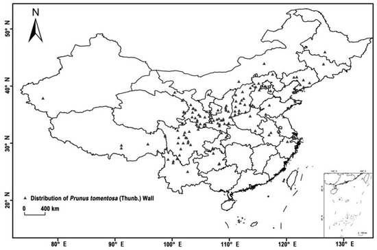
Figure 1.
Distribution record of Prunus tomentosa (Thunb.) Wall in China. The gray dots in the figure represent the existing distribution of P. tomentosa.
2.3. Environmental Variables
The “Fifth Climate Change Assessment Report” published by the Intergovernmental Panel on Climate Change in 2014 uses four greenhouse gas concentration scenarios to represent different concentration paths (RCP): RCP2.6, RCP4.5, RCP6, and RCP8.5. In this study, we downloaded the climate data variables of three periods (contemporary, 2050s, 2070s) through the WorldClim database (http://www.worldclim.org/, last accessed on 15 October 2021), mainly including 19 bioclimatic variables. Two future atmospheric circulation models (CCSM4 and MIROC-ESM) and two typical concentration paths (RCP4.5 and RCP8.5) were used to compose four future climate scenarios: RCP4.5-2050, RCP4.5-2070, RCP8.5-2050, and RCP8.5-2070. The spatial distribution rate was 2.5′. To avoid over-fitting the model, it is important to ensure the quality of the model [14]. This paper used the software ENMTools to perform a Pearson correlation analysis on 19 bioclimatic variables [15]. Using 0.80 as the threshold, after pre-modeling with MaxEnt software, the result was analyzed by comprehensive factor contribution rate (percent contribution), knife cutting method (Jackknife), and the importance of replacement value. When the absolute value of the correlation coefficient between two bioclimatic factors is greater than 0.80 [16], an environmental variable with a large contribution rate is selected.
2.4. Model Setting and Selection
2.4.1. Model Optimization
Because the setting of feature parameters has a greater impact on the MaxEnt model [17], it is necessary to optimize the selection of the feature class (FC) and regularization multiplier (RM) before building the model. The feature class include Linear features (L), Quadratic features (Q), Product features (P), Hinge features (H), and Threshold features (T). When the number of training data exceeds 80, all FC are used; when the number of samples is 15~75, L, Q, and H are used; when the number of training data is 10~14, L and Q are used; when the number of samples is less than 10, only L is used.
In this study, six specific element type combinations (L, H, LQ, LQH, LQHP, and LQHPT) were set with eight regularization multipliers (0.5–4, 0.5) at intervals of 0.5, and finally, 48 parameter combinations were formed. The default parameter settings in MaxEnt were FC as LQHPT and RM as 1. After the species redundancy screening, 137 P. tomentosa were randomly selected. A total of 70% of the points are used as training data, and the other 30% of the P. tomentosa were used as the testing data to test the reliability of the model with the help of the <kuem> script. Finally, the R program was used to obtain the optimal factor type (LQHPT) and the regularization multiplier (3.0) with Akaike’s Information Criterion with small-sample correction (AICc) as the indicator.
2.4.2. Model Building
The remaining geographic distribution data and environmental variables of P. tomentosa were imported into the MaxEnt software, and the model parameters were set. FC was LQHPT, RM was 3.0, the non-repetitive sampling method (subsample) was adopted, the maximum number of repetitions was 5000, the maximum number of background points was 10,000, the number of repetitions was 10, and the default settings were selected for the remainder.
2.4.3. Model Predictive Evaluation
The maximum entropy model has rich variable forms and can fit many complex relationships. Therefore, the model constructed by MaxEnt is also prone to overfitting [18]. To avoid overfitting, this study used three model complexity evaluation indicators to select the best model. The three evaluation indicators were: (1) the area under the ROC curve (AUC). AUC is not affected by the threshold, which leads to more objective evaluation results, and is widely used to reflect the accuracy of prediction [19] and has a value which is generally between 0.5 and 1. Comparing the AUC values of the training set and the test set, the former is higher than the latter. The closer the AUC value is to 1, the greater the correlation between the climate variable and the geographic distribution of the species and the better the prediction effect [20]. The evaluation criteria were: 0.50–0.60 as failed, 0.60–0.70 as poor, 0.70–0.80 as fair, 0.80–0.90 as good, and 0.90–1.00 as excellent [21]. (2) A 10% omission rate (OR10) was threshold-dependent. If the omission rate is greater than 10%, it means that the model is over-fitting [22]. (3) AICc can usually be used to test the complexity and fit of the model. The model with the lowest AICc value (DAICc = 0) is considered the best model among the current models.
2.4.4. Suitable Area Level Partition
The species prediction distribution map reflects the species’ preference for habitat in the form of probability (0–1) [23]. The closer the relative probability is to 1, the more suitable the conditions are for the species’ survival. The choice of optimal threshold depends on the specific research problem (the nature of the research, existing data, and specific research objectives). Different thresholds will cause significant differences in suitability classification [24]. According to the MaxEnt modeling results, Logistic Threshold “Equate entropy of thresholded and original distributions” (0.1265) was closer to the actual distribution of contemporary P. tomentosa in China. The distribution predicted by the model using this threshold was highly consistent with the current distribution of P. tomentosa in China. Below the threshold was the unsuitable zone (0.0511~0.1265) and above the threshold corresponded to the low (0.1265~0.4177), moderate (0.4177~0.7088), and high (0.7088~1.000) suitability zones.
2.4.5. Low Impact Area
With the help of DIVA-GIS, the simulation results were reclassified according to the threshold, the two-dimensional prediction maps of suitable areas in the three periods of contemporary (1960–1990), and the 2050s and the 2070s were superimposed; the overlapping part was taken to define the areas suitable for P. tomentosa. These areas were calculated based on the number of grids.
3. Results and Analysis
3.1. Model Evaluation
When the feature type was LQHPT and the regularization multiplier was 3, the AICc value was the smallest. According to the model prediction result of MaxEnt software (Figure 2), the average AUC value (0.936) of the optimized model was significantly higher than the random distribution model AUC value (0.5). The comparison results of the parameters in the model optimization process are shown in Figure 3. However, the model fit under the default parameters was slightly higher than that of the optimized model, with an average AUC of 0.939. The optimized AUC value of the validation set (0.932) was higher than the default parameter model AUC value (0.922), which showed that the accuracy of the model had improved. In addition, for the mean value of the 10% omission rate, the optimized model (0.097) is significantly smaller than the default model (0.21), which again shows that the optimized model significantly reduces the overfitting of the model.
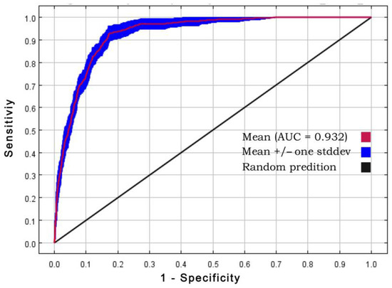
Figure 2.
Receiver operating characteristic (ROC) curve of results obtained from the simulation performed ten times.
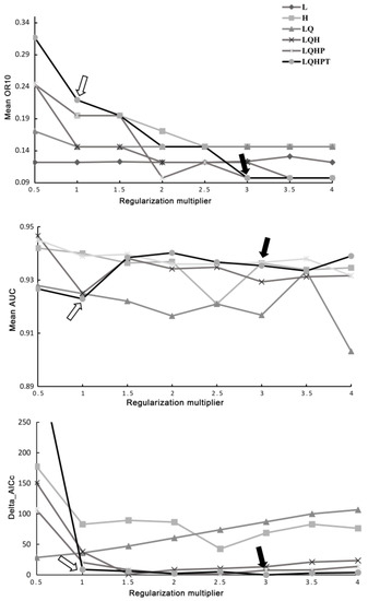
Figure 3.
Performances of the maximum entropy model under different settings. The white arrow indicates the MaxEnt default parameter, and the black arrows indicate the parameters of the optimization.
3.2. Environmental Variables
The contribution rate of environmental factors to the MaxEnt model and the results of the knife-cut method are shown in Table 1. The top four environmental variables with contribution rates are in order: Bio11, Bio8, Bio19, and Bio5, with a cumulative contribution rate of 94.3%. The top four environmental variables with permutation importance are in order: Bio11, Bio18, Bio8, and Bio12, with a cumulative contribution rate of 82.1%. A Jackknife test of the AUC value (Figure 4), among which Bio11, Bio18, and Bio19 had a greater impact on the model. Combining the above results and Pearson correlation analysis, we excluded Bio 12 and Bio 13, which were considerably related to Bio 18, and Bio 8 that was significantly related to Bio 5. Bio11, Bio18, Bio19, Bio5, and Bio15 were determined to be the main environmental variables affecting the distribution of P. tomentosa.

Table 1.
Contribution percentage of each environmental faction MaxEnt modeling.
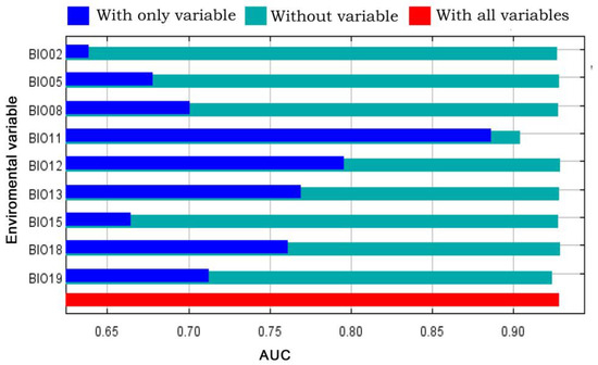
Figure 4.
Jackknife test of Area under the Curve (AUC) value.
3.3. Suitable Distribution Area
P. tomentosa is found growing in more than 20 provinces and cities in China. Among them, Guangdong, Fujian, and Zhejiang were not suitable areas. The most desirable areas were mainly concentrated in Gansu, Shaanxi, Shanxi, and Henan, with a total area of 25.87 × 10⁴ km2 (Table 2), which is approximately 2.5% of China’s total land area. The total area of low-grade suitable areas was 189.28 × 10⁴ km2, accounting for 19.7% of China’s total area; the total area of moderately suitable areas was 130.55 × 10⁴ km2, accounting for 13.6% of China’s total area. Based on the contemporary suitable areas, the environmental conditions projected to the future ages were the results from predicting the future potential distribution areas of P. tomentosa (Figure 5). Our findings suggest that the total suitable area for this species to grow is increasing and moving to the north, which is consistent with findings of Ni. [25]. With the influence of global warming, the cultivation boundaries of many crops will move north and the layout of crops under cultivation will also vary.
Table 2.
The suitable areas of P. tomentosa under different climate change scenarios.
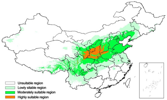
Figure 5.
Potential geographical distribution of P. tomentosa under contemporary climate conditions.
The predicted distributions varied under different greenhouse gas concentration scenarios. At RCP4.5, the total suitable areas for the 2050s and the 2070s were 463.48 × 10⁴ km2 and 512.57 × 10⁴ km2, respectively; at RCP8.5, the total suitable areas for the 2050s and the 2070s were 514.98 × 10⁴ km2 and 584.87 × 10⁴ km2, respectively. Under the scenario of high CO2 concentration, the suitable cultivation area of P. tomentosa was increased compared with the medium concentration of CO2. Gansu and Shaanxi are still highly suitable areas; however, their distribution areas in Shaanxi have moved significantly to the northwest. The original small areas of Chongqing and Guizhou, which are moderately suitable, will gradually become less suitable for the cultivation of P. tomentosa in the context of future climate change (Figure 6).
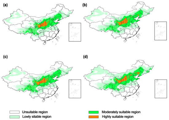
Figure 6.
Potential geographical distribution of P. tomentosa under future climate change scenarios. (a) Representative concentration pathway (RCP) 4.5-2050s, (b) Representative concentration pathway (RCP) 8.5-2050s, (c) Representative concentration pathway (RCP) 4.5-2070s and (d) Representative concentration pathway (RCP) 8.5-2070s.
Under the two emission scenarios of RCP4.5 and RCP8.5 in 2050 and 2070, the variation range of the relatively stable and suitable areas for P. tomentosa in China was relatively small. When greenhouse gas emissions were at a high concentration, the relatively stable suitable area was reduced by 4.62 × 10⁴ km2, while the low impact area (LIA) in Jiangsu has a more significant decrease (Figure 7).
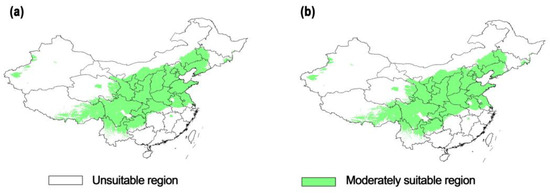
Figure 7.
Low impact area under different RCP in the future. (a) Low impact area (LIA)-RCP4.5, (b) Low impact area (LIA)-RCP8.5.
4. Discussion
4.1. The Impact of Model Complexity on Model Accuracy
When the prediction model fits the test set too closely in the environment space, the training set cannot be predicted truly and independently, and overfitting is prone to occur. Similarly, models that do not match (models with inappropriate complexity) cannot provide sufficient distinction, therefore the predictive performance of the model is poor. According to research, the insufficient fitting and over-fitting of the MaxEnt model not only lacks versatility, but also affects the transferability of the model [26]. In this study, the complexity of the MaxEnt model was reduced by adjusting the regularization multiplier and feature type to accurately predict the potential geographic distribution of P. tomentosa.
The optimal model parameters selected by the AICc minimum were different from the MaxEnt default parameters. Under the default parameter setting, OR10 was significantly higher than that of the optimized model. Under the default parameter setting, the model exhibited an over-fitting phenomenon, which reduced transferability. In this case, adjusting parameters of the model to reduce the spatial dimension is an effective way to improve the transferability of the model [27]. When the element type is constant, increasing the regularization multiplier value can also significantly improve the transferability of the model, but a value that is too high can easily lead to missing information [28]. In this study, when RM was 3.0 and FC was LQHPT, the AICc value was the smallest, and the model contained missing information with the best fit, implying that it was the best model.
4.2. Environmental Variables and Potential Distribution
The main environmental factors affecting the potential distribution of P. tomentosa were precipitation and temperature. This mainly included the mean temperature of the coldest quarter, precipitation of the warmest quarter, precipitation of the coldest quarter, the maximum temperature of the warmest month, and precipitation seasonality. P. tomentosa has a wide temperature adaptation range with humidity and temperature. In the future climate scenario, the average annual precipitation in South China will decrease by 0 to 5% and increase by 0 to 20% in the rest of China [29], which may be the potential reason for the high contribution of specific variables. Under future climatic conditions, precipitation in Guizhou, Chongqing, and Yunnan will decrease significantly [30]. The precipitation and the number of wet days in Northeast China have increased [31]. This rise in humidity within a certain range is beneficial to the growth of P. tomentosa. This phenomenon is also reflected in the forecast map. This study used two atmospheric circulation models (CCSM4 and MIROC-ESM). It expands on the research of Wei et al. [32] superimposing prediction layers corresponding to the two atmospheric circulation models to take their average value and integrating them into the final single-layer result. MaxEnt software was used to combine modern climatic conditions with two typical concentration paths (RCP4.5 and RCP8.5) under future climatic conditions, thereby predicting the potential zoning of P. tomentosa in contemporary and future eras. In terms of the total area of the potential geographical distribution area of P. tomentosa in China, the total area of RCP4.5-2050s, RCP4.5-2070s, RCP8.5-2050s, and RCP8.5-2070s increased. However, the area change of the moderately suitable region was not as obvious as that of the low suitability region. The distribution of P. tomentosa in Xinjiang was the most significant. They are cultivated more in the Hebei Province. Most of them are scattered in central and northern Liaoning and southern Jilin [33], and the potential distribution of the prediction model is closely correlated with its actual distribution. Under the high CO2 emission scenario, Gansu and Shanxi were still highly suitable areas. Chongqing and Guizhou will change from a small number of moderately suitable areas to low suitability areas. The potential distribution of P. tomentosa has moved northwards. In the future, this predicted trend can be combined with that obtained from the research of Gao, Z.X. [34], which can significantly increase the role of P. tomentosa in the afforestation and greening of bare unvegetated hills, thereby accelerating the greening of the northwest arid land. Increasingly harmful climate change may lead to the extinction of nearly a quarter of the world’s species [35]. In the future, the relatively stable suitable growing area for P. tomentosa will gradually decrease. This prediction result further reminds foresters that they should pay attention to protecting wild P. tomentosa germplasm resources and maintaining the diversity of hairy cherry germplasm resources.
5. Conclusions
This study selected the appropriate feature class (LQHPT) and the regularization multiplier (3.0) to optimize the model and explored the main factors limiting the ecological distribution of P. tomentosa ecological distribution in 19 bioclimatic variables for Bio11, Bio18, Bio19, Bio5, and Bio15. The P. tomentosa is mainly distributed in North China, the northwest, and the southwest in the current climate. In the present and future, P. tomentosa has shown good adaptability in Gansu, Shaanxi, Shanxi, and Henan.
In the future, the potential geographic distribution of P. tomentosa in China will gradually expand to the northwest. With global warming, the potential geographic distribution of Xinjiang will change significantly. In the introduction and cultivation, low-impact areas of P. tomentosa should be considered. Simultaneously, the role of P. tomentosa in the greening of bare and unvegetated hills and wastelands should be fully utilized to improve its current status as rootstocks for maximizing its economic and ecological benefits. Stress resistance tests can be performed in the low-adaptability area to further understand the response of cherry to adversity and promote the protection of germplasm resources of P. tomentosa.
Supplementary Materials
The following are available online at https://www.mdpi.com/article/10.3390/f13030381/s1, Table S1: Latitude and longitude data of the collection locations of P. tomentosa used in Maxent analyses.
Author Contributions
Conceptualization, B.F. and J.Y.; methodology, Q.Q.; software, Q.Q.; validation, B.F., J.Y. and Q.Q.; formal analysis, Q.Z.; investigation, Q.Z.; resources, B.F.; data curation, J.Y.; writing—original draft preparation, B.F. and Q.Q.; writing—review and editing, J.Y.; visualization, Q.Z.; supervision, J.Y.; project administration, B.F.; funding acquisition, J.Y. All authors have read and agreed to the published version of the manuscript.
Funding
This research was funded by the Youth Innovation Team Project of the Chongqing Academy of Agricultural Sciences (NKY-2019QC08), National Natural Science Foundation of China (31772260), and Chongqing Study Abroad Innovation Project (cx2019052).
Institutional Review Board Statement
Not applicable.
Informed Consent Statement
Not applicable.
Data Availability Statement
The latitude and longitude data used in this study are available in Table S1. All data generated by this study are available from the corresponding author upon reasonable request.
Acknowledgments
We would like to thank the Chinese National Specimen Resource Sharing Platform and Plant Science Data Center-China Plant Species Information System for their support with the species distribution data.
Conflicts of Interest
The authors declare no conflict of interest.
References
- Hamilton, E.; Maughan, T.; Black, B. Nanking Cherry in the Garden; Utah State University Extension: Logan, Utah, 2016. [Google Scholar]
- Lang, J.P.; Zhang, Z.J.; Zhang, Q.P.; Wang, X.J.; Bi, S.H. A preliminary report on water and soil conservation benefit and economic value of Prunus tomentosa. Soil Water Conserv. Sci. Technol. Shanxi 1995, 2, 25–26. (In Chinese) [Google Scholar]
- He, H.L. Genetic Diversity and Populations Genetic Structure of Wild. Prunus tomentosa in Northern China Using Simple Sequence Repeats (SSRS) Markers; Northwest A&F University: Shaanxi, China, 2015. (In Chinese) [Google Scholar]
- Wei, L.M.; Qin, Y.; Gao, B.Y. Development and Utilization of Prunus tomentosa Resources. Forest By-Prod. Spec. China 2017, 2, 87–88. (In Chinese) [Google Scholar]
- Wang, Y.S.; Xie, B.Y.; Wan, F.H.; Xiao, Q.M.; Dai, L.Y. Application of ROC curve analysis in evaluating the performance of alien species’ potential distribution models. Biodivers. Sci. 2007, 15, 365–372. (In Chinese) [Google Scholar]
- Martínez-Meyer, E.; Peterson, A.T.; Servín, J.I.; Kiff, L.F. Ecological niche modelling and prioritizing areas for species reintroductions. Oryx 2006, 40, 411–418. [Google Scholar] [CrossRef][Green Version]
- Engler, R.; Guisan, A.; Rechsteiner, L. An improved approach for predicting the distribution of rare and endangered species from occurrence and pseudo-absence data. J. Appl. Ecol. 2004, 41, 263–274. [Google Scholar] [CrossRef]
- Honig, M.A.; Cowling, R.M.; Richardson, D.M. The invasive potential of australian banksias in south african fynbos: A comparison of the reproductive potential of Banksia ericifolia and Leucadendron laureolum. Aust. Ecol. 1992, 17, 305–314. [Google Scholar] [CrossRef]
- Garza, G.; Rivera, A.; Venegas-Barrera, C.S.; Martinez-Ávalos, J.G.; Dale, J.; Feria-Arroyo, T.P. Potential effects of climate change on the geographic distribution of the endangered plant species manihot walkerae. Forests 2020, 11, 689. [Google Scholar] [CrossRef]
- Carpenter, G.; Gillison, A.N.; Winter, J. Domain: A flexible modelling procedure for mapping potential distributions of plants and animals. Biodivers. Conserv. 1993, 2, 667–680. [Google Scholar] [CrossRef]
- Rong, Z.; Zhao, C.; Liu, J.; Gao, Y.; Zang, F.; Guo, Z.; Mao, Y.; Wang, L. Modeling the effect of climate change on the potential distribution of qinghai spruce (Picea Crassifolia Kom.) in qilian mountains. Forests 2019, 10, 62. [Google Scholar] [CrossRef]
- Costa, G.C.; Nogueira, C.; Machado, R.B.; Colli, G.R. Sampling bias and the use of ecological niche modeling in conservation planning: A field evaluation in a biodiversity hotspot. Biodivers. Conserv. 2010, 19, 883–899. [Google Scholar] [CrossRef]
- Phillips, S.J.; Anderson, R.P.; Schapire, R.E. Maximum entropy modeling of species geographic distributions. Ecol. Model. 2006, 190, 231–259. [Google Scholar] [CrossRef]
- Merow, C.; Smith, M.J.; Silander, J.A. A practical guide to maxent for modeling species’ distributions: What it does, and why inputs and settings matter. Ecography 2013, 36, 1058–1069. [Google Scholar] [CrossRef]
- Warren, D.L.; Seifert, S.N. Ecological niche modeling in maxent: The importance of model complexity and the performance of model selection criteria. Ecol. Appl. 2011, 21, 335–342. [Google Scholar] [CrossRef]
- Parolo, G.; Rossi, G.; Ferrarini, A. Toward improved species niche modelling: Arnica montana in the Alps as a Case Study. J. Appl. Ecol. 2008, 45, 1410–1418. [Google Scholar] [CrossRef]
- Zhu, G.P.; Yuan, X.J.; Fan, J.Y.; Wang, M.L. Effects of model parameters in max ent modeling of ecological niche and geographic distribution: Case study of the brown marmorated stink bug, Halyomorpha Haly. Biosafety 2018, 27, 118–123. (In Chinese) [Google Scholar]
- Yu, Y.Z.; Zhang, M.H.; Du, H.R.; Li, Q.; Zhang, L.B.; Mu, W.J. Optimized MAXENT model in simulating distribution of suitable habitat of moose. J. Northeast For. Univ. 2019, 47, 81–84, 95. (In Chinese) [Google Scholar]
- Xu, D.; Zhou, Z.; Wang, R.; Ye, M.; Pu, B. Modeling the distribution of Zanthoxylum armatum in China with MaxEnt modeling. Glob. Ecol. Conserv. 2019, 19, e00691. [Google Scholar] [CrossRef]
- Zhang, T.; Huang, Z.H.; Peng, Y.J.; Wang, Y.T.; Wang, P.; Wang, S.T.; Cui, G.F. Prediction of potential suitable areas of actinidia arguta in china based on MaxEnt model. Acta Ecol. Sin. 2020, 40, 4921–4928. (In Chinese) [Google Scholar]
- Swets, J.A. Measuring the accuracy of diagnostic systems. Science 1988, 240, 1285–1293. [Google Scholar] [CrossRef]
- Muscarella, R.; Galante, P.J.; Soley-Guardia, M.; Boria, R.A.; Kass, J.M.; Uriarte, M.; Anderson, R.P. ENM Eval: An R package for conducting spatially independent evaluations and estimating optimal model complexity for maxent ecological niche models. Methods Ecol. Evol. 2014, 5, 1198–1205. [Google Scholar] [CrossRef]
- Xu, Z.L.; Peng, H.H.; Peng, S.Z. The development and evaluation of species distribution models. Acta Ecol. Sin. 2015, 35, 557–567. (In Chinese) [Google Scholar]
- Poirazidis, K.; Bontzorlos, V.; Xofis, P.; Zakkak, S.; Xirouchakis, S.; Grigoriadou, E.; Kechagioglou, S.; Gasteratos, I.; Alivizatos, H.; Panagiotopoulou, M. Bioclimatic and environmental suitability models for capercaillie (Tetrao Urogallus) conservation: Identification of optimal and marginal areas in rodopi mountain-range National Park (Northern Greece). Glob. Ecol. Conserv. 2019, 17, e00526. [Google Scholar] [CrossRef]
- Ni, J. Impacts of climate change on Chinese ecosystems: Keyvulnerable regions and potential thresholds. Reg. Environ. Change 2011, 11, 49–64. [Google Scholar] [CrossRef]
- Radosavljevic, A.; Anderson, R.P. Making better maxent models of species distributions: Complexity, overfitting and evaluation. J. Biogeogr. 2014, 41, 629–643. [Google Scholar] [CrossRef]
- Anderson, R.P.; Gonzalez, I. Species-specific tuning increases robustness to sampling bias in models of species distributions: An implementation with maxent. Ecol. Model. 2011, 222, 2796–2811. [Google Scholar] [CrossRef]
- Zhang, T.J.; Liu, G. Study of methods to improve the temporal transferability of niche model. J. China Agric. Univ. 2017, 22, 98–105. (In Chinese) [Google Scholar]
- Jiang, D.B.; Fu, Y.H. Climate change over china with a 2 °C global warming. Chin. J. Atmos. Sci. 2012, 36, 234–246. (In Chinese) [Google Scholar]
- Zhang, J.Y.; Li, Y.; Wang, Y.T.; Li, Z.Y.; Huang, C.R. Impact of climate change on geological disaster in southwest china. Plateau Mt. Meteorol. Res. 2020, 40, 70–77. (In Chinese) [Google Scholar]
- Li, X.H. Analysis of Thermal and Precipitation Resources in Northeast China under Greenhouse Gas Emission Scenarios; Shenyang Agricultural University: Shenyang, China, 2019. (In Chinese) [Google Scholar]
- Wei, J.F.; Li, X.Z.; Lu, Y.Y.; Zhao, L.; Zhang, H.F.; Zhao, Q. Modeling the potential global distribution of phenacoccus madeirensis green under various climate change scenarios. Forests 2019, 10, 773. (In Chinese) [Google Scholar] [CrossRef]
- Gao, B.N.; Qin, Y.; Wei, L.M. The advantages of planting multifunctional fruit tree Prunus tomentosa in cold regions. Agric. Technol. 2017, 37, 40. (In Chinese) [Google Scholar]
- Gao, Z.X. Popularization and application of drought—Resistant afforestation techniques for Prunus tomentosa. Inner Mong. For. Investig. Des. 2015, 38, 72–115. (In Chinese) [Google Scholar]
- Lindner, M.; Maroschek, M.; Netherer, S. Climate change impacts, adaptive capacity, and vulnerability of European forest ecosystems. For. Ecol. Manag. 2010, 259, 698–709. [Google Scholar] [CrossRef]


Publisher’s Note: MDPI stays neutral with regard to jurisdictional claims in published maps and institutional affiliations. |
© 2022 by the authors. Licensee MDPI, Basel, Switzerland. This article is an open access article distributed under the terms and conditions of the Creative Commons Attribution (CC BY) license (https://creativecommons.org/licenses/by/4.0/).