Article

Incorporating Ecosystem Service Multifunctionality and Its Response to Urbanization to Identify Coordinated Economic, Societal, and Environmental Relationships in China

1
College of Architecture and Environment, Sichuan University, Chengdu 610064, China
2
School of Public Administration, Sichuan University, Chengdu 610064, China
*
Author to whom correspondence should be addressed.
Forests 2022, 13(5), 707; https://doi.org/10.3390/f13050707
Submission received: 3 March 2022 / Revised: 26 April 2022 / Accepted: 26 April 2022 / Published: 30 April 2022

Abstract

:
Urbanization poses a threat to ecosystems and contributes to the degradation of the environment. It is of great importance to identify coordinated economic, societal, and environmental relationships with key ecological functions and services to achieve regional sustainability. Based on a case study in China, this study seeks to fill this gap by estimating the spatial distribution of ecosystem service multifunctionality (ESM) and its spatially heterogeneous response to urbanization. First, the biophysical values of five typical ecosystem services (ESs) (carbon storage, habitat quality, net primary production, soil conservation, and water yield) were assessed based on several simulation models. The biophysical values of these ESs were then standardized and summed to obtain the spatial distribution of ESM. Afterward, the urbanization level was evaluated, and finally, the spatial interaction between urbanization and ESM was exhibited based on the bivariate Moran’s I and Getis-Ord Gi* statistic. The results showed that: (1) the ESM showed obvious spatial heterogeneity in southeastern and northwestern China, with a gradual decline from the coast to the interior; (2) ESM and urbanization had different spatial distribution patterns and produced significant local aggregation effects; and (3) harmonious relationships between ESM and urbanization were observed in southeastern coastal China and the surrounding areas of the North China Plain, which were related to the capacity of local coastal ecosystems, mangrove forests, and aquatic ecosystems to provide multiple services and goods simultaneously. Our results suggest that multifunctional ecosystems can realize a ‘win–win’ situation for ecological conservation and socioeconomic development. The results of this study can advance our understanding of the ecological effects of urbanization on ecosystems and provide valuable implications for the coordinated development of humans and nature in the rapid urbanization process.

1. Introduction

Toward promoting the coordinated development of the global economy, society, and environment, the 2030 Agenda for Sustainable Development of the United Nations (UN) proposes 17 universal sustainable development goals (SDGs) and 169 targets [1]. There is evidence that ecological environments and a sustainable supply of ecosystem services are essential to the achievement of SDGs [2]. Ecosystem services (ESs) refer to the goods and services that people derive from ecosystems, which are indispensable for human survival and well-being [3]. In addition, ecosystems have diverse functions and can provide multilevel services to humans simultaneously [4]. In this study, the capacity of an ecosystem to simultaneously provide multiple ecosystem functions and services is defined as ecosystem service multifunctionality (ESM) [5,6,7]. ESM research contributes to identifying changes in ecosystem functions and structure and the associated impacts of human disturbance and guides ecological conservation and ecosystem management decisions [7,8].
During the past decade, urbanization has become one of the most noticeable characteristics of social development and poses a significant threat to regional ES provision [9,10]. In the process of urbanization, rapid land expansion transforms natural or semi land into semiartificial ecosystems and urban ecosystems, which seriously modifies the structure and function of local ecosystems and weakens the ability of the ecosystems to provide various services to humans [11,12,13]. As a result, ESM may not necessarily be presented at the same level [5]. Moreover, notable population growth and rapid economic development may directly contribute to an increase in the demand for good services and products, such as food, raw materials, and energy [14,15,16]. However, the uneven distribution of ESM may directly affect the capacity of ESs to support human well-being and may aggravate social crises, such as resource scarcity, land desertification, and poor soil fertility, which in turn seriously threaten regional ecological security and limit economic development [17,18,19]. In this context, a better understanding of the relationship between urbanization and ESM is fundamental for clarifying the ecological effects of urbanization on ecosystems and offering strategic guidance for ecosystem decision-making [20,21].
Recently, an increasing amount of attention has been given to understanding how ESs respond to urbanization [22,23]. To date, urbanization has proven to be a significant factor in the field of ESs, such as ecosystem service value (ESV) [15,24], ES supply [20,25,26,27,28], and ES supply-demand ratios [29,30]. For example, Arowolo et al. [31] evaluated changes in the ecosystem service values in response to land use/land cover dynamics in Nigeria. Taking the Pearl River Delta (PRD) urban agglomeration as the case study area, Zhang et al. [23] quantified four typical ESs and quantitatively evaluated the impact of urbanization on ES supply and demand. Pan and Wang [30] used the geographically weighted regression (GWR) model to explore the spatially heterogeneous response of ES supply, demand, and supply–demand ratios to different types of urbanization (i.e., population, economy, and land) in China. Generally, research on the effects of urbanization on ESs has mainly focused on the biophysical or economic value of ESs, while, few have treated the multifunctionality of the ecosystem as a complete whole [32]. Furthermore, previous studies have focused on the relationship between ESs and urbanization at a small scale [33,34], while little attention has been paid to a large scale in countries such as China. Regional differences in the urbanization level have a more remarkable spatial heterogeneity at a large scale.
China has been identified as a representative area for studying human–land interactions [33]. As the largest developing country in the world, China has undergone unprecedented large-scale urban expansion after the implementation of the reform and opening-up policy in 1978, accompanied by substantial landscape change, ecological land shortages, and ecosystem degradation [30]. One key challenge is that the function of ecosystems and associated ES supply may be threatened by the combined effect of urban development and increasing social demands [18]. Thus, considering the adverse effects of rapid urbanization, more attention should be given to understanding the relationship between urbanization and ESM [35,36]. Moreover, China has implemented a series of regional development strategies. Due to the vastness of the territory and high heterogeneity of resource endowments, however, the level of urban development showed significant regional variations in China [30]. Therefore, it is of strategic and practical importance to clarify the spatially heterogeneous responses of ESM to urbanization, identify areas with different levels of urbanization and ESM clustering, and explore possible economic, social, and environmental coordination relationships in China [37].
The objectives of this study were as follows: (1) map the spatial distribution of ESM and estimate the spatial response pattern of ESM to urbanization; (2) identify regions where different levels of urbanization and ESM cluster together and (3) explore the potential coordinated economic, societal, and environmental relationships.
Therefore, taking China as a case study, this study sought to estimate the spatially heterogeneous responses of ESM to urbanization and explore possible economic, social and environmental coordination relationships. The biophysical values of five critical ESs (carbon storage, habitat quality, net primary production (NPP), soil conservation, and water yield) were assessed through several simulation models. Then, the biophysical values of these ESs were standardized and summed to obtain the spatial distribution of ESM. Afterward, the urbanization level was evaluated, and finally, the spatial interaction between the urbanization level and ESM was exhibited based on the bivariate Moran’s I and Getis-Ord Gi* statistic.

2. Materials and Methods

2.1. Study Area

China is located in eastern Asia along the western coast of the Pacific Ocean and its geographical coordinates are 3°31′ N~53°33′ N, 73°29′ E~135°2′ E (Figure 1) [38]. The total area of the region is approximately 960 × 104 km2 [39]. China has a complex topography with high values in the north and low values in the south and exhibits a ladder-shaped decline from north to south. The altitude range is between −155 m (Aydin Lake) and 8844 m (Mount Everest), and the slope range is between 0° and 62°, with several typical geomorphic types, including mountains, plateaus, hills, basins, and plains. In addition, China presents a wide range of climatic zones and consequently a variety of ecosystems, including farmland and forest ecosystems in the eastern regions and grassland and desert ecosystems in the western areas. The main land-use types in the study area are grassland, which accounts for 29.21% of the total area, followed by forestland (22.01%) and unused land (20.89%) in 2020 (http://www.stats.gov.cn/) (accessed on 1 December 2021).
In terms of socioeconomic characteristics, since the 1980s, the economy, population density, and construction land area have risen substantially as a result of rapid urbanization in China [30]. From 1978 to 2021, the proportion of the urban population increased from 17.92% to 63.89%, and the area of urban construction land increased from 6720 km2 to 61,300 km2 (obtained from China’s National Bureau of Statistics) (http://www.stats.gov.cn/) (accessed on 2 December 2021). Such accelerating urban construction and industrial development have also led to profound landscape change and serious ecosystem deterioration in China [39]. In this regard, alleviating ecological pressure and resolving environmental problems are becoming increasingly urgent in China [40].

2.2. Data Sources

In this study, several basic category datasets were collected, including digital land-use datasets, vegetation data, topographic data, soil data, meteorological data, and socioeconomic data. (1) Digital land use data (2020, 30 m × 30 m) were obtained from the Resource and Environment Science and Date Center (http://www.resdc.cn/) (accessed on 15 July 2021) and divided into six first-level categories (cropland, forestland, grassland, water-body, construction land, and bare land) based on the National Standard Land-Use Classification of China using supervised classification [41]. (2) Normalized difference vegetation index (NDVI) data (2020, 1000 m × 1000 m) were provided by the Resource and Environment Science and Date Center (http://www.resdc.cn/) (accessed on 16 July 2021). (3) Digital elevation model data (30 m × 30 m) was obtained from the Geospatial Data Cloud Platform (http://www.gsclooud.cn) (accessed on 20 July 2021). (4) Soil data (1:1,000,000) were obtained from the Chinese Soil DataSet (v1.1) of the Harmonized World Soil Database 1.1 (HWSD) which was constructed by the United Nations Food and Agriculture Organization (FAO) and the Vienna International Institute for Applied Systems (IIASA) [42]. (http://www.fao.org/soils-portal/soil-survey/soil-maps-and-databases/) (accessed on 23 July 2021). (5) Meteorological data (2020, text) were downloaded from the Chinese National Meteorological Science Data Service Center, such as precipitation, temperature, solar radiation, and humidity (http://data.cma.cn/) (accessed on 25 July 2021). (6) Socioeconomic datasets (2020, 1000 m × 1000 m) were provided by the Resource and Environment Science and Data Center (http://www.resdc.cn/)(accessed on 27 July 2021), including population density and gross domestic product. In this study, all datasets were reprocessed to the China Geodetic Coordinate System 2000 (CGCS2000), which is suitable for studies in China, and resampled to 1000 m spatial resolution. All the spatial data were processed and mapped with the help of ArcGIS software (version 10.6).

2.3. ES Quantification

The benefits that people derive from ecosystem functions are defined as ecosystem services (ESs) [43,44]. Sometimes a single ecosystem service (ES) is the result of more than one ecosystem function, and in other instances, a single ecosystem function can contribute to more than one ES [44]. This study selected five typical ESs that are important to the study area, namely, carbon storage (CS), habitat quality (HQ), net primary production (NPP), soil conservation (SC), and water yield (WY), based on the following considerations: (1) CS is a key indicator in ES assessment because of its significant contribution to the regulation of local climate [23]; (2) China is known as a megadiversity country, rich in species with many nature reserves; (3) many ecological restoration projects taking place in this region may result in an increase in ecological land and a change in the spatial distribution of rainfall; (4) the local environmental problem of soil erosion is very serious due to the complex geomorphology and the centuries-long agricultural practices on the slopes; and (5) WY is a vital ES supply to support human well-being. Table 1 provides the evaluation methods and key input parameters for evaluating the five ESs.

2.3.1. Carbon Storage (CS)

Carbon storage (CS) service denotes the ability of an ecosystem to absorb atmospheric carbon dioxide [8,23]. In this work, CS was quantified using the carbon storage module in the integrated valuation of ES and trade-offs (InVEST) model [45]. For each land use type, the carbon storage module estimates the amount of carbon stored in four major carbon pools, namely, aboveground biomass, belowground biomass, soil carbon, and dead organic matter.

2.3.2. Habitat Quality (HQ)

Habitat quality (HQ) service refers to the ability of an ecosystem to provide appropriate conditions for the persistence of individuals and populations, and it depends on the proximity of the habitat to human land uses and the intensity of these land uses. The HQ was calculated by using the habitat quality module in the InVEST model [46]. The habitat quality module combines information on land use and threats to biodiversity to produce habitat quality maps and requires the following factors: each threat’s relative impact, the relative sensitivity of each habitat type to each threat, the distance between habitats and sources of threats, and the degree to which the land is legally protected [45].

2.3.3. Net Primary Production (NPP)

Net primary production (NPP) is defined as the amount of organic energy generated by plants per unit area in a given amount of time [47]. NPP was quantified using the Carnegie-Ames-Stanford approach (CASA) model [48]. In the CASA model, NPP is calculated based on the absorbed photosynthetically active radiation (APAR) multiplied by the light energy conversion.

2.3.4. Soil Conservation (SC)

Soil conservation (SC) service refers to the important functions of ecosystems to reduce the loss of soil fertility. SC can be quantified by using the Revised Universal Soil Loss Equation (RUSLE) model, which is most widely used to calculate the average annual soil erosion of an area [49]. In this model, SC is estimated based on the difference between potential soil erosion and actual soil erosion [47].

2.3.5. Water Yield (WY)

Water yield (WY) is defined as the capacity of an ecosystem to retain water, such as by intercepting precipitation, enhancing soil infiltration, inhibiting evaporation, mitigating surface runoff, and increasing precipitation [50]. In this research, WY was predicted using the water yield module in the InVEST model, which is based on the water balance model and determines the annual water yield of different pixels by using the Budyko curve and the annual total precipitation data [51].

2.4. ESM Quantification

Natural ecosystems typically provide more than one ecosystem service (ES) to support human wellbeing and existence [52]. The capacity of an ecosystem to simultaneously provide multiple ecosystem services (ESs) is defined as the ecosystem service multifunctionality (ESM) [5,6,7]. In this work, ESM was estimated by using the multifunctional sum approach, which is based on the sum of the standardized values of five ESs [34,53]. First, to eliminate the different evaluation methods and units among the five ESs, the biophysical values of each service were standardized to a value between 0 and 1 using range standardization. The range standardization formula was as follows [8,20]:
E S s t d = ( E S o b s E S m i n ) / ( E S m a x E S m i n )
where E S s t d   is the standardized value of each E S ; E S o b s   represents the observed value of each E S ; and E S m i n   and E S m a x   denote the minimum and maximum values of each E S , respectively.
Second, the standardized values of five ESs were summed to obtain the values of ESM [54]. The formula of the ESM was as follows [7]:
  ESM = i = 1 5 w i × E S s t d i
where w i   and E S s t d i   represent the weight and normalized value of each E S , respectively. Considering that the five services all play an important role in the local ecosystems of China, the contributions of CS, HQ, NPP, SC, and WY to ESM were treated equally [7,8]. Thus, the weight of each ES was set to 1 and the value of ESM varied between 0 and 5. In this work, higher ESM values represent a greater capacity of the ecosystems to provide more ESs [7].

2.5. Urbanization Level Quantification

According to the definitions of urbanization, the urbanization level can be measured in the following aspects: population agglomeration, economic development, and land expansion [55]. In this work, three indicators, namly, population density (POP, person/km2), gross domestic product (GDP, Chinese yuan/km2), and the proportion area of construction land (PCL, %), were selected to measure population urbanization, economic urbanization, and land urbanization, respectively [24,30]. Three indicators were standardized by using the range method and then averaged to derive the urbanization level index.

2.6. Spatial Relationship Analysis

To understand the spatial relationships between the ESM and urbanization, this study took the following three steps. First, Moran’s I coefficient (I) was used to determine the spatial autocorrelation of ESM and urbanization. It can be calculated as follows [56]:
I = n i = 1 n j = 1 n W i j ( x i x ¯ ) ( x j x ¯ ) i = 1 n j = 1 n W i j ( x i x ¯ ) 2
where n   is the total number of regions; x i   and x j   represent the observed values of regions i   and j , respectively; x ¯ is the mean value of x , and W i j is the spatial weight. Specifically, Moran’s I coefficients close to 0, 1, and −1 indicate that the spatial patterns of ESM and urbanization tend to be random, clustered, and dispersed, respectively.
Second, hot and cold spots analysis (Getis–Ord Gi* method) was performed to test the spatial heterogeneity of ESM and urbanization. The Getis-Ord Gi* statistic has been widely used to identify the locations of statistically significant high-value clusters (hot-spots) and low-value clusters (cold-spots) [57]. The formula is as follows [8,58]:
G i * ( d ) = i = 1 n W i j ( d ) X j / j = 1 n X j
Z ( G i * ) = G i * E ( G i * ) V a r ( G i * )
where n is the total number of regions; X j   represents the observed value of region j ; W i j   is the spatial weight, and V a r ( G i * )   and E ( G i * )   represent the variable coefficient and expectation value, respectively. In this work, statistically significant negative z-scores (cold spots) denote an aggregation of low values (z-score ≤ −1.96), whereas statistically significant positive z-scores (hot spot) indicate an aggregation of high values (z-score ≥ 1.96) [54].
Last, the bivariate Moran’s I between the ESM and urbanization and their local indicator of spatial association (LISA) map were calculated by using GeoDa software. The p-value was determined to identify significant correlations, with p ≤ 0.05 indicating significant differences [33,59]. The local Moran’s I ( I i ) is expressed as [56]:
I i = n ( x i x ¯ ) i j n w i j ( x j x ¯ ) i = 1 n ( x i x ¯ ) 2
where n is the total number of regions; x i   and x j   represent the observed values of regions i and j , respectively; x ¯ is the mean value of x , and w i j is the spatial weight. Specifically, according to the level of difference between ESM and urbanization, the local Moran’s I ( I i ) was divided into four types regions [56]. The details of each type region are described in Table 2.

3. Results

3.1. Spatial Distribution of Ecosystem Services

As shown in Figure 2, the spatial distribution of the five ESs shows remarkable spatial heterogeneity between the northwest and southeast regions in China. Higher values of NPP, SC, and WY are mainly located in the southeast coastal areas, while lower values of NPP, SC, and WY are mostly distributed in Inner Mongolia, Northwest China, and Tibet. In addition, we find a gradual decline in WY values from the south to the north and from the coast to the interior. The regions with good HQ and CS are mainly observed in southeastern China, and low HQ and CS predominantly occur in Northwest China, the Northeast China Plain, the North China Plain, and Sichuan Basin.

3.2. Spatial Pattern of ESM

According to Figure 3a, the spatial distribution of ESM varies across space, but is generally spatially clustered. Overall, there is obvious spatial heterogeneity of ESM in the southeast and northwest regions, with a gradually decreasing trend from the coast to the interior. Specifically, regions with low ESM values mainly appear in Inner Mongolia, the Tibetan Plateau, and Northwest China. In addition, areas with low ESM values are also observed in the North China Plain and Northeast Plain. Due to better climatic and hydrological conditions, the areas with higher ESM levels are mainly found in the southeastern coastal region [8].

3.3. Spatial Pattern of Urbanization

In contrast to the spatial distribution of ESM, the spatial distribution of urbanization displays different characteristics. In general, the low values of urbanization are mainly distributed in the western part of the study area, while the high values are distributed in the eastern part (Figure 3b). In northeast China, there are also areas with lower levels of urbanization. Areas with higher urbanization levels are mainly concentrated in the eastern part of the country, especially in urban agglomerations.

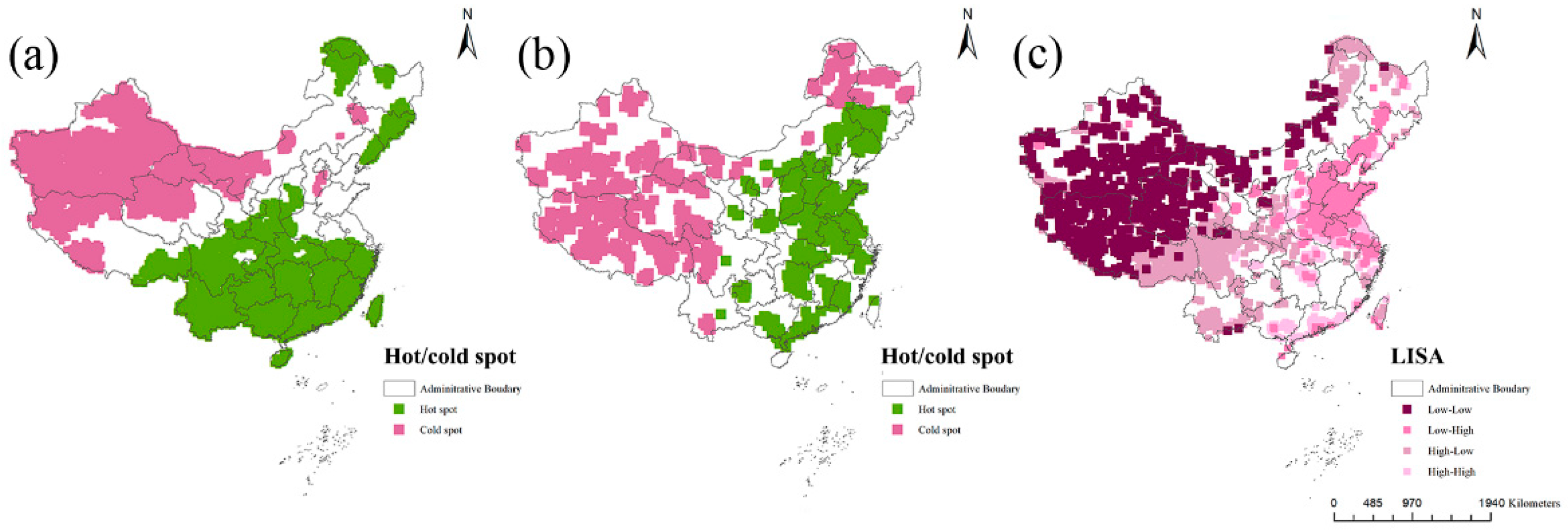
3.4. Spatial Relationship between Urbanization and ESM

As shown in Table 3, the Moran’s I for ESM and urbanization in 2020 were 0.80 and 0.75, respectively, implying that there is a significant positive spatial autocorrelation for both urbanization and ESM in China.
The results of the hot and cold spot analysis are shown in Figure 4a,b, illustrating that the cold and hot spot areas of urbanization and ESM exhibit significant spatial variations and strong spatial aggregation effects within the study area. As shown in Figure 4a, cold spots of ESM are mainly scattered in western Inner Mongolia, the Tibetan Plateau, and Northwest China, while hot spot areas are mainly centered in southern China. In terms of urbanization, the hot spots are mainly located in Northwest China and the Tibetan Plateau, while the cold spots are mainly observed in the North China Plain (Figure 4b).
Figure 4 and Table 4 show that the spatial relationship between ESM and urbanization in China includes four types regions: High-High (HH) cluster, Low-High (LH) cluster, High-Low (HL) cluster, and Low-Low (LL) cluster. According to Table 5 and Figure 4c, the High-Low cluster is prominent and occurs mainly in southwestern and northern China. Low-High cluster is observed primarily in the North China Plain. In the southeastern coastal areas and areas surrounding Low-High clusters, High-High clusters are most prevalent, indicating that urbanization and ESM had a synergistic relationship in these areas. Low-Low cluster is primarily found in the Tibetan Plateau and Northwest China.

4. Discussion

4.1. Spatial Relationship between Ecosystem Services and ESM

Figure 2 and Figure 4 show that significant spatial similarity exists in the relationship between ESs and ESM. In particular, according to Figure 2 and Figure 4, the lowest levels of ESM and ESs are mainly located in the Northwest China, such as the Tarim Basin, the Turpan Basin, and the Quasi-Georgia Basin. These regions have low vegetation coverage, with unused land coverage of more than 86%. These results indicate that unused land, such as abundant sand, bare land, and bare rock, may have a lower ability to provide multiple ESs.
Lower values of ESM are mostly distributed in the Inner Mongolia, Tibetan Plateau, and North China Plain, which is consistent with the spatial variation in CS, NPP, SC, and WY. However, it is worth noting that compared to the North China Plain, the HQ levels in Inner Mongolia and the Tibetan Plateau are relatively high. This is mainly because the main land use types in the North China Plain are cropland and construction land, while the Qinghai-Tibet Plateau and Inner Mongolia Plateau are grasslands [30]. These results suggest that grasslands may play a role in maintaining HQ levels in China.
The regions with higher ESM and ESs are mainly observed in the southern and southeastern parts of China, where forest coverage exceed 60% [8]. The results show that forests in the southern and southeastern parts of China may possess a higher level of ESM and are capable of providing multiple ESs to society. Thus, in these areas, management emphasis should be laid on protecting and recovering the local natural vegetation and coordinating the relationships between socioeconomic development and ecological management.
Briefly, as shown in Figure 2 and Figure 4, it can be seen that there may be significant differences in ESM levels across land use types in China. Forests in southern and southeastern China may have a higher level of ESM and are capable of providing multiple ESs to society.

4.2. The Relationship between Urbanization and ESM

4.2.1. High-High Type Region

According to the LISA map, the ESM in China displays a notable spatially heterogeneous response to urbanization and this association may be positive or negative at the regional level. For example, as shown in Figure 4c, although a significant global negative association is observed between urbanization and ESM, a positive relationship between urbanization and ESM still occurs in southeastern coastal China. The possible reason may lie in the fact that coastal ecosystems present several provisioning services, such as fishing and fishing-related activities, seaweed farming, fuel, timber, and other products [60]. In addition, because of the better climatic and hydrological conditions, land cover in these areas is dominated by natural forest vegetation, especially mangrove forests [2]. Mangrove forests have great potential not only for the provision of multiple marine products but also for coastal protection, climate and hydrologic regulation, seawater purification, carbon sequestration, habitat provision for marine species, and maintenance of coastal ecological stability [61,62]. The conservation of mangrove forest cover is essential to maintaining high levels of ESM in these regions. Hence, ecological projects such as mangrove forest conservation and restoration and coastal shelterbelt restoration should be strongly supported to maintain the ESs of ecosystems in southeastern coastal China [8].
In this work, the High-High regions are also found in the areas surrounding the North China Plain, indicating that the local ecosystems are capable of resisting the negative impacts of urbanization. These findings may be explained by the presence of water bodies, such as Taihu Lake and the Yangtze River, which are capable of maintaining the ecological balance of the river basin, such as biodiversity conservation, climate regulation, and waste treatment [63]. Therefore, the management and enhancement of ESM can be targeted at the water environments in these areas. It is an important and urgent mission for the government to search for effective measures to promote a sustainable aquatic ecosystem and utilize water resources in the surrounding areas of the North China Plain. A series of environmental conservation projects, such as converting farmland into lakes, replacing fishing areas with lakes, and protecting lakeside wetlands, should be implemented to stabilize the ecological structure and function and maintain the aquatic ecosystem carrying capacity [64].

4.2.2. Low-High Type Region

We also find that Low-High regions are mainly distributed in the North China Plain. These areas are located in the central and northern parts of the study area with flat terrain and low altitude, which is good for population agglomeration, economic development, and rapid urban expansion [65]. However, significant urban sprawl accounts for a considerable amount of local ecological land, including forests, grasslands, and wetlands, and has led to a modification of the local landscape and ecosystem structure and function [66]. A direct consequence is the diminished supply of ESs and reduced level of ESM. These findings are consistent with numerous studies worldwide indicating that agriculture and urban expansion negatively affect the provision of ESs [67,68]. In the Low-High region, therefore, the primary objective should be to prevent overdevelopment while ensuring coordinated and high-quality development of economic growth and ecological protection, including ESs, to ensure local sustainable development [63,64]. The application of various strategies, such as enforcing land policies and ecological policies and adhering strictly to the ecological red line policy, will contribute to regulating the size and intensity of new land-use transitions and strengthening the protection of important ecological spaces [34]. It is worth noting that on the North China Plain, the expansion of construction land is unavoidable with the ongoing urbanization process. Thus, in response to the increasing ecological risks in rapidly urbanized areas, policy-makers can optimize urban spatial arrangements, such as by establishing green infrastructure, protecting existing green space, and enhancing highly connected ecological networks [69,70].

4.2.3. Low-Low Type Region

Furthermore, we find that the Low-Low regions are mainly distributed in the western parts of the study area. There are two reasons for this phenomenon. Figure 4c shows that the Low-Low type is largely clustered in the Tibetan Plateau and Northwest China and these areas are dominated by bare land and alpine grassland. The low level of ESM may be caused by the different capacities of land-use types to provide ESs [71]. Furthermore, climate factors are also an important factor in determining the spatial pattern of the ESM. The local harsh environmental conditions, such as high altitudes and dry climates, influence not only local social and economic development but also the types and extent of local vegetation [22,33,72]. Therefore, for northwestern China, ecological policies should continue to support the conservation of local ecosystems and the extension of local vegetation coverage. Given the fragile ecological environment and the nation’s strategic positioning, these areas should actively implement several ecological conservation and restoration programs, such as returning farmland to forest and implementing the Three-North Shelter Belt program, to increase grassland and forest coverage and enhance the quality and stability of local ecosystems. Furthermore, ecological protection zones need to be established and protected to maintain the supply of ESs and promote the integration and connection of ecological land in northwest China.

4.2.4. High-Low Type Region

High-Low regions are mainly located in Southwest China. Urbanization development in these regions may be influenced by the local natural and topographical environment [73]. For instance, the large hilly and mountainous areas with high altitudes limit various human production activities and urban sprawl development in the southwest region [74]. Consequently, the rich natural resources and ecological environment of the region have been protected and maintained, so that the overall ESM remains high in southwest China. Furthermore, the southwestregion of China is a rich source of biological and forest resources and contains several significant species resources and ecologically sensitive zones, such as in Northwest Yunnan and areas south of Hengduan Mountain. Therefore, it is important to improve the quantity and quality of local natural resources in these districts. Ecological policies, including the shelter-belt program for the upper and middle reaches of the Yangtze River, should further strengthen the protection of local ecosystems and avoid overdevelopment and utilization in the future. In addition, changes in the proportion of different species are associated with changes in the perpendicular band spectrum of the regional vegetation [24]. Thus, ESs provided by ecosystems differ on a vertical scale. It is, therefore, necessary to increase attention to the vertical structure of local vegetation, improve soil nutrient conditions, and promote the restoration of ecosystems in the southwestern region.

4.3. Implications for Sustainability Management

A major focus of current research is the coordinated development of the global economy, society, and environment [2]. Urbanization is an inevitable characteristic of socioeconomic development, and balancing its relationship with ecological conservation is the key to achieving sustainability. Spatially explicit approaches are becoming increasingly important in regional sustainable development due to their ability to intuitively reflect spatial details and provide place-based information [71]. In China, the southeastern coastal area and the North China Plain are extremely important economic development areas. A major finding of this study is that local coastal ecosystems, mangrove forests, and aquatic ecosystems contribute to a harmonious relationship between ESM and urbanization because they provide multiple provisioning services (such as fishing and fishing-related activities, seaweed farming, fuel, timber, and other products) and regulating services (such as biodiversity conservation, climate and hydrologic regulation, waste treatment) simultaneously to humans. This provides good evidence that, in the context of rapid urbanization, multifunctional ecosystems may contribute to a ‘win–win’ situation for ecological conservation and socioeconomic development.
We suggest that to ensure the health level of the ecosystem, the continuous provisioning of a wide range of ESs, and the sustainable development of different regions, government policy-makers should conduct regional land use management and conservation based on the following aspects. First, land use management should focus on land use types that have a higher potential in terms of ES supply and economic value. Nevertheless, we strongly oppose the blind pursuit of maximizing a specific provisioning service while ignoring its trade-off effect on other services. Therefore, the synergies and trade-offs among ESs and the supply thresholds of the ecosystems should also be considered to achieve long-term ecological sustainability with less ES degradation [20,65].
Under the pressure of rapid urbanization, it is of great importance to clarify the ecological effects of urbanization on ecosystems and identify coordinated economic, societal, and environmental relationships with key ecological functions and services to achieve regional sustainability. Despite the importance of ESM in ecosystem management and landscape-scale policy-making [7,8], studies have focused on quantifying the relationship between urbanization and ESs, and little attention has been devoted to the study of ESM [5,8]. According to our study, a methodology of estimating the spatial distribution of ESM and its spatially heterogeneous response to urbanization can help us to identify the harmonious relationship between the economy and the environment, which can be transferred to other areas. In the process of rapid urbanization, this work can contribute to clarifying the ecological impacts of urbanization on ecosystems and provide strategic guidance for local decision-making regarding the coordinated development of humans and nature.

4.4. Limitations

The following limitations applied within the context of this study could be further explored in future studies. First, only five typical ESESs indicators were selected and quantified in this study, and other vital ESs, such as food supply [20], air pollution removal [22], and local recreation [23], were not investigated due to a lack of available data and feasible quantification methods. Thus, in future research, we will consider more service types to more accurately calculate ESM. Second, this paper only discussed the spatial heterogeneity of ESM from natural and socioeconomic perspectives; however, other environmental factors may also affect ecosystems, for example, global climate change and soil properties [39].

5. Conclusions

Based on the spatial distribution of ESM and its spatially heterogeneous response to urbanization, coordinated economic, societal, and environmental relationships are identified in this study. The results show that ESM in China presents significant spatial heterogeneity, with low levels of ESM mainly concentrated in Inner Mongolia, the Tibetan Plateau, and Northwest China and higher levels of ESM observed in the North China Plain, Northeast China Plain, and southeastern coastal areas. ESM and urbanization exhibit different spatial distribution patterns and produce a significant local aggregation effect as observed in the following four types: High-Low type, Low-High type, High-High type, and Low-Low type. Coordinated economic, societal, and environmental relationships are mainly distributed in the southeastern coastal area and the North China Plain, which is related to the capacity of local coastal ecosystems, mangrove forests, and aquatic ecosystems to provide multiple services and goods simultaneously. This provides good evidence that, in the context of rapid urbanization, multifunctional ecosystems may contribute to a ‘win–win’ situation for ecological conservation and socioeconomic development. It is hoped that this study can offer a relevant theoretical basis and reference for decision-making to achieve regional sustainable development.

Author Contributions

Conceptualization, Y.H. and X.G.; Data curation, Y.H., D.H. and makers X.G.; Investigation, Y.H. and S.N.; Methodology, Y.H., S.N. and X.G.; Project administration, X.G.; Resources, D.H. and B.Z.; Software, S.N. and D.H.; Supervision, X.G. and B.Z.; Validation, Y.H. and D.H.; Visualization, Y.H. and S.N.; Writing—original draft, Y.H.; Writing—review & editing, S.N., X.G. and B.Z. All authors have read and agreed to the published version of the manuscript.

Funding

This work was funded by the National Natural Science Foundation of China (No. 51108284).

Data Availability Statement

Not applicable.

Conflicts of Interest

The authors declare no conflict of interest.

References

  1. United Nations. Transforming our world: The 2030 Agenda for Sustainable Development. 2015. Available online: https://www.un.org/sustainabledevelopment/energy/ (accessed on 10 December 2021).
  2. Chen, D.; Zhao, Q.; Jiang, P.; Li, M. Incorporating ecosystem services to assess progress towards sustainable development goals: A case study of the Yangtze River Economic Belt, China. Sci. Total Environ. 2022, 806, 151277. [Google Scholar] [CrossRef] [PubMed]
  3. Costanza, R.; Groot, R.D.A.; Farber, S.; Belt, M. The value of the world’s ecosystem services and natural capital. Ecol. Econ. 1997, 25, 3–15. [Google Scholar] [CrossRef]
  4. Millennium Ecosystem Assessment. Ecosystems and Human Well-Being: Synthesis; World Resource Institute: Washington, DC, USA, 2005. [Google Scholar]
  5. Velepucha, P.E.; Luna, T.O.; Torres, B.; Lippe, M.; Günter, S. Ecosystem Service Multifunctionality: Decline and Recovery Pathways in the Amazon and Chocó Lowland Rainforests. Sustainability 2020, 12, 7786. [Google Scholar] [CrossRef]
  6. Hölting, L.; Jacobs, S.; Felipe-Lucia, M.R.; Maes, J.; Norström, A.V.; Plieninger, T.; Cord, A.F. Measuring ecosystem multifunctionality across scales. Environ. Res. Lett. 2019, 14, 124083. [Google Scholar] [CrossRef] [Green Version]
  7. Manning, P.; Van Der Plas, F.; Soliveres, S.; Allan, E.; Maestre, F.T.; Mace, G.; Whittingham, M.J.; Fischer, M. Redefining ecosystem multifunctionality. Nat. Ecol. Evol. 2018, 2, 427–436. [Google Scholar] [CrossRef]
  8. Liu, C.; Yang, M.; Hou, Y.; Xue, X. Ecosystem service multifunctionality assessment and coupling coordination analysis with land use and land cover change in China’s coastal zones. Sci. Total Environ. 2021, 797, 149033. [Google Scholar] [CrossRef]
  9. Holt, A.R.; Mears, M.; Maltby, L.; Warren, P. Understanding spatial patterns in the production of multiple urban ecosystem services. Ecosyst. Serv. 2015, 16, 33–46. [Google Scholar] [CrossRef] [Green Version]
  10. Mach, M.E.; Martone, R.G.; Chan, K.M.A. Human impacts and ecosystem services: Insufficient research for trade-off evaluation. Ecosyst. Serv. 2015, 16, 112–120. [Google Scholar] [CrossRef]
  11. Estoque, R.C.; Murayama, Y. Landscape pattern and ecosystem service value changes: Implications for environmental sustainability planning for the rapidly urbanizing summer capital of the Philippines. Landsc. Urban Plan. 2013, 116, 60–72. [Google Scholar] [CrossRef]
  12. Hasan, S.S.; Lin, Z.; Miah, M.G.; Ahamed, T.; Samie, A. Impact of land use change on ecosystem services: A review. Environ. Dev. 2020, 34, 100527. [Google Scholar] [CrossRef]
  13. Martin, D.; Osen, K.; Grass, I.; Hölscher, D.; Tscharntke, T.; Wurz, A.; Kreft, H. Land-use history determines ecosystem services and conservation value in tropical agroforestry. Conserv. Lett. 2020, 13, e12740. [Google Scholar] [CrossRef]
  14. Ahmed, Z.; Zafar, M.W.; Ali, S.; Khan, D. Linking urbanization, human capital, and the ecological footprint in G7 countries: An empirical analysis. Sustain. Cities Soc. 2020, 55, 102064. [Google Scholar] [CrossRef]
  15. Bryan, B.A.; Ye, Y.; Zhang, J.; Connor, J.D. Land-use change impacts on ecosystem services value: Incorporating the scarcity effects of supply and demand dynamics. Ecosyst. Serv. 2018, 32, 144–157. [Google Scholar] [CrossRef]
  16. Wolff, S.; Schulp, C.J.E.; Kastner, T.; Verburg, P.H. Quantifying Spatial Variation in Ecosystem Services Demand: A Global Mapping Approach. Ecol. Econ. 2017, 136, 14–29. [Google Scholar] [CrossRef]
  17. Galvani, A.P.; Bauch, C.T.; Anand, M.; Singer, B.H.; Levin, S.A. Human-environment interactions in population and ecosystem health. Proc. Natl. Acad. Sci. USA 2016, 113, 14502–14506. [Google Scholar] [CrossRef] [Green Version]
  18. Mastrangelo, M.E.; Weyland, F.; Villarino, S.H.; Barral, M.P.; Nahuelhual, L.; Laterra, P. Concepts and methods for landscape multifunctionality and a unifying framework based on ecosystem services. Landsc. Ecol. 2014, 29, 345–358. [Google Scholar] [CrossRef]
  19. Vaezi, A.R.; Ahmadi, M.; Cerdà, A. Contribution of raindrop impact to the change of soil physical properties and water erosion under semi-arid rainfalls. Sci. Total Environ. 2017, 583, 382–392. [Google Scholar] [CrossRef]
  20. Peng, J.; Tian, L.; Liu, Y.; Zhao, M.; Hu Yn Wu, J. Ecosystem services response to urbanization in metropolitan areas: Thresholds identification. Sci. Total Environ. 2017, 607–608, 706–714. [Google Scholar] [CrossRef]
  21. Quintas-Soriano, C.; Castro, A.J.; Castro, H.; García-Llorente, M. Impacts of land use change on ecosystem services and implications for human well-being in Spanish drylands. Land Use Policy 2016, 54, 534–548. [Google Scholar] [CrossRef]
  22. Li, B.; Chen, D.; Wu, S.; Zhou, S.; Wang, T.; Chen, H. Spatio-temporal assessment of urbanization impacts on ecosystem services: Case study of Nanjing City, China. Ecol. Indic. 2016, 71, 416–427. [Google Scholar] [CrossRef]
  23. Zhang, Z.; Peng, J.; Xu, Z.; Wang, X.; Meersmans, J. Ecosystem services supply and demand response to urbanization: A case study of the Pearl River Delta, China. Ecosyst. Serv. 2021, 49, 101274. [Google Scholar] [CrossRef]
  24. Chen, W.; Zhao, H.; Li, J.; Zhu, L.; Wang, Z.; Zeng, J. Land use transitions and the associated impacts on ecosystem services in the Middle Reaches of the Yangtze River Economic Belt in China based on the geo-informatic Tupu method. Sci. Total Environ. 2020, 701, 134690. [Google Scholar] [CrossRef] [PubMed]
  25. Cumming, G.S.; Buerkert, A.; Hoffmann, E.M.; Schlecht, E.; von Cramon-Taubadel, S.; Tscharntke, T. Implications of agricultural transitions and urbanization for ecosystem services. Nature 2014, 515, 50–57. [Google Scholar] [CrossRef] [PubMed]
  26. Fedele, G.; Locatelli, B.; Houria, D.; Colloff, M. Reducing risks by transforming landscapes: Cross-scale effects of land-use changes on ecosystem services. PLoS ONE 2018, 13, e0195895. [Google Scholar] [CrossRef]
  27. Pham, H.V.; Sperotto, A.; Torresan, S.; Acuña, V.; Jorda-Capdevila, D.; Rianna, G.; Marcomini, A.; Critto, A. Coupling scenarios of climate and land-use change with assessments of potential ecosystem services at the river basin scale. Ecosyst. Serv. 2019, 40, 101045. [Google Scholar] [CrossRef]
  28. Winowiecki, L.; Vågen, T.-G.; Huising, J. Effects of land cover on ecosystem services in Tanzania: A spatial assessment of soil organic carbon. Geoderma 2016, 263, 274–283. [Google Scholar] [CrossRef] [Green Version]
  29. Chen, J.; Jiang, B.; Bai, Y.; Xu, X.; Alatalo, J.M. Quantifying ecosystem services supply and demand shortfalls and mismatches for management optimisation. Sci. Total Environ. 2019, 650, 1426–1439. [Google Scholar] [CrossRef]
  30. Pan, Z.; Wang, J. Spatially heterogeneity response of ecosystem services supply and demand to urbanization in China. Ecol. Eng. 2021, 169, 106303. [Google Scholar] [CrossRef]
  31. Arowolo, A.O.; Deng, X.; Olatunji, O.A.; Obayelu, A.E. Assessing changes in the value of ecosystem services in response to land-use/land-cover dynamics in Nigeria. Sci. Total Environ. 2018, 636, 597–609. [Google Scholar] [CrossRef]
  32. Field, R.D.; Parrott, L. Multi-ecosystem services networks: A new perspective for assessing landscape connectivity and resilience. Ecol. Complex. 2017, 32, 31–41. [Google Scholar] [CrossRef]
  33. Chen, W.; Chi, G.; Li, J. The spatial association of ecosystem services with land use and land cover change at the county level in China, 1995–2015. Sci. Total Environ. 2019, 669, 459–470. [Google Scholar] [CrossRef] [PubMed]
  34. Lang, Y.; Song, W. Quantifying and mapping the responses of selected ecosystem services to projected land use changes. Ecol. Indic. 2019, 102, 186–198. [Google Scholar] [CrossRef]
  35. Qiu, B.; Li, H.; Zhou, M.; Zhang, L. Vulnerability of ecosystem services provisioning to urbanization: A case of China. Ecol. Indic. 2015, 57, 505–513. [Google Scholar] [CrossRef]
  36. Wu, X.; Liu, S.; Zhao, S.; Hou, X.; Xu, J.; Dong, S.; Liu, G. Quantification and driving force analysis of ecosystem services supply, demand and balance in China. Sci. Total Environ. 2019, 652, 1375–1386. [Google Scholar] [CrossRef]
  37. Cao, S.; Xia, C.; Suo, X.; Wei, Z. A framework for calculating the net benefits of ecological restoration programs in China. Ecosyst. Serv. 2021, 50, 101325. [Google Scholar] [CrossRef]
  38. Piao, S.; Ciais, P.; Huang, Y.; Shen, Z.; Peng, S.; Li, J.; Zhou, L.P.; Liu, H.Y.; Ma, Y.C.; Ding, Y.H.; et al. The impacts of climate change on water resources and agriculture in China. Nature 2010, 467, 43–51. [Google Scholar] [CrossRef]
  39. Yuan, Y.; Chen, D.; Wu, S.; Mo, L.; Tong, G.; Yan, D. Urban sprawl decreases the value of ecosystem services and intensifies the supply scarcity of ecosystem services in China. Sci. Total Environ. 2019, 697, 134170. [Google Scholar] [CrossRef]
  40. Chen, T.; Feng, Z.; Zhao, H.; Wu, K. Identification of ecosystem service bundles and driving factors in Beijing and its surrounding areas. Sci. Total Environ. 2020, 711, 134687. [Google Scholar] [CrossRef]
  41. Ye, Y.; Zhang, J.; Bryan, B.A.; Gao, L.; Qin, Z.; Chen, L.; Yang, J. Impacts of Rapid Urbanization on Ecosystem Services along Urban-Rural Gradients: A Case Study of the Guangzhou-Foshan Metropolitan Area, South China. Écoscience 2018, 25, 1–13. [Google Scholar] [CrossRef]
  42. Fischer, G.; Nachtergaele, F.; Prieler, S.; Velthuizen HTv Verelst, L.; Wiberg, D. Global Agro-Ecological Zones Assessment for Agriculture (GAEZ 2008); FAO: Rome, Italy; Laxenburg, Austria, 2008. [Google Scholar]
  43. Daily, G.R. Nature’s Services: Societal Dependence on Natural Ecosystems. Environ. Values 1998, 7, 365–367. [Google Scholar]
  44. Costanza, R.; d’Arge, R.; De Groot, R.; Farber, S.; Grasso, M.; Hannon, B.; Limburg, K.; Naeem, S.; O’neill, R.V.; Paruelo, J.; et al. The value of the world’s ecosystem services and natural capital. Nature 1997, 387, 253–260. [Google Scholar] [CrossRef]
  45. Sharp, R.; Chaplin-Kramer, R.; Wood, S.; Guerry, A.; Douglass, J. InVEST User’s Guide; Stanford University: Stanford, CA, USA, 2018. [Google Scholar] [CrossRef]
  46. Tallis, H.; Ricketts, T.H.; Daily, G.C.; Polasky, S. Natural Capital: Theory and Practice of Mapping Ecosystem Services; Oxford University Press: Oxford, UK, 2011; pp. 34–48. [Google Scholar]
  47. Sun, Z.; Li, Y.-S.; Liu, Y.; Ren, J.; Zhou, D. Spatially Explicit Analysis of Trade-Offs and Synergies among Multiple Ecosystem Services in Shaanxi Valley Basins. Forests 2020, 11, 209. [Google Scholar] [CrossRef] [Green Version]
  48. Potter, C.S.; Randerson, J.T.; Field, C.B.; Matson, P.A.; Vitousek, P.M.; Mooney, H.A.; Klooster, S.A. Terrestrial Ecosystem Production: A Process Model Based on Global Satellite and Surface Data. Glob. Biogeoch. Cycles 1993, 7, 811–841. [Google Scholar] [CrossRef]
  49. Renard, K. Predicting Soil Erosion by Water: A Guide to Conservation Planning with the Revised Universal Soil Loss Equation (RUSLE); U.S. Department of Agriculture: Washington, DC, USA, 1997; p. 404.
  50. Wang, C.; Li, W.; Sun, M.; Wang, Y.; Wang, S. Exploring the formulation of ecological management policies by quantifying interregional primary ecosystem service flows in Yangtze River Delta region, China. J. Environ. Manag. 2021, 284, 112042. [Google Scholar] [CrossRef]
  51. Sharp, R.; Tallis, H.; Ricketts, T.; Guerry, A.D.; Wood, S.A.; Chaplin-Kramer, R. InVEST User’s Guide; Version 3.5.0; The Natural Capital Project; Stanford University: Stanford, CA, USA, 2015; pp. 123–124. [Google Scholar]
  52. Hao, R.; Yu, D.; Wu, J. Relationship between paired ecosystem services in the grassland and agro-pastoral transitional zone of China using the constraint line method. Agric. Ecosyst. Environ. 2017, 240, 171–181. [Google Scholar] [CrossRef]
  53. Meerow, S.; Newell, J.P. Spatial planning for multifunctional green infrastructure: Growing resilience in Detroit. Landsc. Urban Plan. 2017, 159, 62–75. [Google Scholar] [CrossRef]
  54. Peng, J.; Chen, X.; Liu, Y.; Lü, H.; Hu, X. Spatial identification of multifunctional landscapes and associated influencing factors in the Beijing-Tianjin-Hebei region, China. Appl. Geogr. 2016, 74, 170–181. [Google Scholar] [CrossRef]
  55. Su, S.; Li, D.; Xiao, R.; Zhang, Y. Spatially non-stationary response of ecosystem service value changes to urbanization in Shanghai, China. Ecol. Indic. 2014, 45, 332–339. [Google Scholar] [CrossRef]
  56. Zhang, Z.; Li, Y. Coupling coordination and spatiotemporal dynamic evolution between urbanization and geological hazards—A case study from China. Sci. Total Environ. 2020, 728, 138825. [Google Scholar] [CrossRef]
  57. Schröter, M.; Kraemer, R.; Ceauşu, S.; Rusch, G.M. Incorporating threat in hotspots and coldspots of biodiversity and ecosystem services. Ambio 2017, 46, 756–768. [Google Scholar] [CrossRef]
  58. Getis, A.; Ord, J. The analysis of spatial association by use of distance statistics. Geogr. Anal. 1992, 24, 189–206. [Google Scholar] [CrossRef]
  59. Wang, J.; Zhou, W.; Pickett, S.T.A.; Yu, W.; Li, W. A multiscale analysis of urbanization effects on ecosystem services supply in an urban megaregion. Sci. Total Environ. 2019, 662, 824–833. [Google Scholar] [CrossRef] [PubMed]
  60. Lange, G.-M.; Jiddawi, N. Economic value of marine ecosystem services in Zanzibar: Implications for marine conservation and sustainable development. Ocean Coast. Manag. 2009, 52, 521–532. [Google Scholar] [CrossRef]
  61. Baral, H.; Guariguata, M.R.; Keenan, R.J. A proposed framework for assessing ecosystem goods and services from planted forests. Ecosyst. Serv. 2016, 22, 260–268. [Google Scholar] [CrossRef] [Green Version]
  62. Henriques, M.; Granadeiro, J.P.; Piersma, T.; Leão, S.; Pontes, S.; Catry, T. Assessing the contribution of mangrove carbon and of other basal sources to intertidal flats adjacent to one of the largest West African mangrove forests. Mar. Environ. Res. 2021, 169, 105331. [Google Scholar] [CrossRef] [PubMed]
  63. Lu, Y.; Huang, Y.; Zeng, S.; Wang, C. Scenario-based assessment and multi-objective optimization of urban development plan with carrying capacity of water system. Front. Environ. Sci. Eng. 2019, 14, 21. [Google Scholar] [CrossRef]
  64. Ma, X.; Li, N.; Yang, H.; Li, Y. Exploring the relationship between urbanization and water environment based on coupling analysis in Nanjing, East China. Environ. Sci. Pollut. Res. 2022, 29, 4654–4667. [Google Scholar] [CrossRef]
  65. Sun, X.; He, J.; Shi, Y.; Zhu, X.; Li, Y. Spatiotemporal change in land use patterns of coupled human-environment system with an integrated monitoring approach: A case study of Lianyungang, China. Ecol. Complex. 2012, 12, 23–33. [Google Scholar] [CrossRef]
  66. Song, W.; Deng, X.; Yuan, Y.; Wang, Z.; Li, Z. Impacts of land-use change on valued ecosystem service in rapidly urbanized North China Plain. Ecol. Model. 2015, 318, 245–253. [Google Scholar] [CrossRef]
  67. Portela, R.; Rademacher, I. A dynamic model of patterns of deforestation and their effect on the ability of the Brazilian Amazonia to provide ecosystem services. Ecol. Model. 2001, 143, 115–146. [Google Scholar] [CrossRef]
  68. Collard, S.J.; Zammit, C. Effects of land-use intensification on soil carbon and ecosystem services in Brigalow (Acacia harpophylla) landscapes of southeast Queensland, Australia. Agric. Ecosyst. Environ. 2006, 117, 185–194. [Google Scholar] [CrossRef] [Green Version]
  69. Jenerette, G.D.; Harlan, S.L.; Stefanov, W.L.; Martin, C.A. Ecosystem services and urban heat riskscape moderation: Water, green spaces, and social inequality in Phoenix, USA. Ecol. Appl. 2011, 21, 2637–2651. [Google Scholar] [CrossRef]
  70. Niemelä, J.; Saarela, S.-R.; Söderman, T.; Kopperoinen, L.; Yli-Pelkonen, V.; Väre, S.; Kotze, D.J. Using the ecosystem services approach for better planning and conservation of urban green spaces: A Finland case study. Biodivers. Conserv. 2010, 19, 3225–3243. [Google Scholar] [CrossRef]
  71. Zhang, G.; Zheng, D.; Xie, L.; Zhang, X.; Wu, H.; Li, S. Mapping changes in the value of ecosystem services in the Yangtze River Middle Reaches Megalopolis, China. Ecosyst. Serv. 2021, 48, 101252. [Google Scholar] [CrossRef]
  72. Jin, X.; Jin, Y.; Mao, X. Ecological risk assessment of cities on the Tibetan Plateau based on land use/land cover changes—Case study of Delingha City. Ecol. Indic. 2019, 101, 185–191. [Google Scholar] [CrossRef]
  73. Li, J.; Zhou, Z.X. Natural and human impacts on ecosystem services in Guanzhong—Tianshui economic region of China. Environ. Sci. Pollut. Res. 2016, 23, 6803–6815. [Google Scholar] [CrossRef] [PubMed]
  74. Fang, C.L.; Wang, Y. Quantitative investigation of the interactive coupling relationship between urbanization and eco-environment. Acta Ecol. Sin. 2015, 35, 2244–2254. [Google Scholar] [CrossRef] [Green Version]
Figure 1. Locations of the study area.
Forests 13 00707 g001
Figure 2. Spatial distribution of the carbon storage (a), habitat quality (b), net primary production (c), soil conservation (d), and water yield (e) services in China.
Forests 13 00707 g002
Figure 3. Spatial distribution of the ecosystem service multifunctionality (ESM) (a) and urbanization (b) in 2020.
Forests 13 00707 g003
Figure 4. Spatial pattern of the cold spots and hot spots for ecosystem service multifunctionality (ESM) (a) and urbanization (b), and the spatial. hots pots and aggregation pattern of the ESM and urbanization (c) in 2020. “High-High” refers to High ESM-High urbanization; “Low-High” refers to Low ESM-High urbanization; “Low-Low” refers to Low ESM-Low urbanization; “High-Low” refers to High ESM-Low urbanization.
Forests 13 00707 g004
Table 1. Evaluation methods and indicators for of each ecosystem service.
Ecosystem
Services
MethodEquation
Carbon storageCarbon storage module C C S = C a b o v e + C b e l o w + C s o i l + C d e a d (1)
Habitat qualityHabitat quality module Q x j = H j ( 1 ( D z x j D z x j + k z ) ) (2)
Net primary productionCASA model N P P ( x , t ) = A P A R ( x , t ) × ε ( x , t ) (3)
Soil conservationRUSLE model A = R × K × L S × ( 1 C P ) (4)
Water yieldWater yield module Y = ( 1 A E T P ) × P (5)
Note: (1) C C S   = total carbon storage; C a b o v e   = aboveground carbon storage; C b e l o w   = underground carbon storage; C s o i l   = soil carbon storage; C d e a d = dead matter carbon storage. (2) Q x j   = habitat quality in LUCC j ; H j   = habitat suitability in LUCC j ; D x j   = total threat level in LULC j ; k = scaling parameter. (3) N P P ( x , t ) = the net primary productivity of pix   x   during month t ; A P A R ( x , t )   = absorbed photosynthetically active radiation; ε ( x , t )   = light utilization efficiency of pix   x during month t . (4) A = amount of soil conservation; R = rainfall erosivity factor; K = soil erodibility factor; LS = slope length and steepness factor; C = cover-management factor; P = support practice factor. (5) Y = annual water yield; AET = annual evapotranspiration; P = annual total precipitation.
Table 2. Details of the local indicator of spatial association (LISA) map between ecosystem service multifunctionality (ESM) and urbanization.
DescriptionType Region
I i   >   0 ,   x i x ¯ > 0 Areas with high values of ESM are surrounded by high-value areas of urbanizationHigh-High (H-H) cluster
I i   >   0 ,   x i x ¯ < 0Areas with low values of ESM are surrounded by low-value areas of urbanizationLow-Low (L-L) cluster
I i   <   0 ,   x i x ¯ > 0 Areas with high values of ESM are surrounded by low-value areas of urbanizationHigh-Low (H-L) cluster
I i   <   0 ,   x i x ¯ < 0 Areas with low values of ESM are surrounded by high-value areas of urbanizationLow-High (L-H) cluster
Note: I i = local Moran’s I, x i   = the observed values of regions i , x ¯   = the mean value of x .
Table 3. Moran’s I statistics of ecosystem service multifunctionality (ESM) and urbanization.
Moran’s Ip-Value
ESM0.80<0.01
Urbanization0.75<0.01
Table 4. The mean values of local Moran’s I, ecosystem service multifunctionality (ESM), and urbanization in four types regions.
Type RegionLocal Moran’s IESMUrbanization
High-High 1.142.24.61
Low-Low0.280.620.02
Low-High −0.711.158.07
High-Low −0.272.340.05
Table 5. The proportion of the four type regions.
Type RegionNumberProportion
High-High 3650.15
Low-Low 5550.24
Low-High5130.22
High-Low9250.39
Publisher’s Note: MDPI stays neutral with regard to jurisdictional claims in published maps and institutional affiliations.

