
A Review of Forest Fire Combating Efforts, Challenges and Future Directions in Peninsular Malaysia, Sabah, and Sarawak


Abstract
:1. Introduction
2. Related Forest Fire Studies in Malaysia
2.1. Root Causes and Impacts of Forest Fire
2.2. Fire Susceptibility Mapping Utilising Remote Sensing
2.3. Other Efforts Associated with Forest Fire
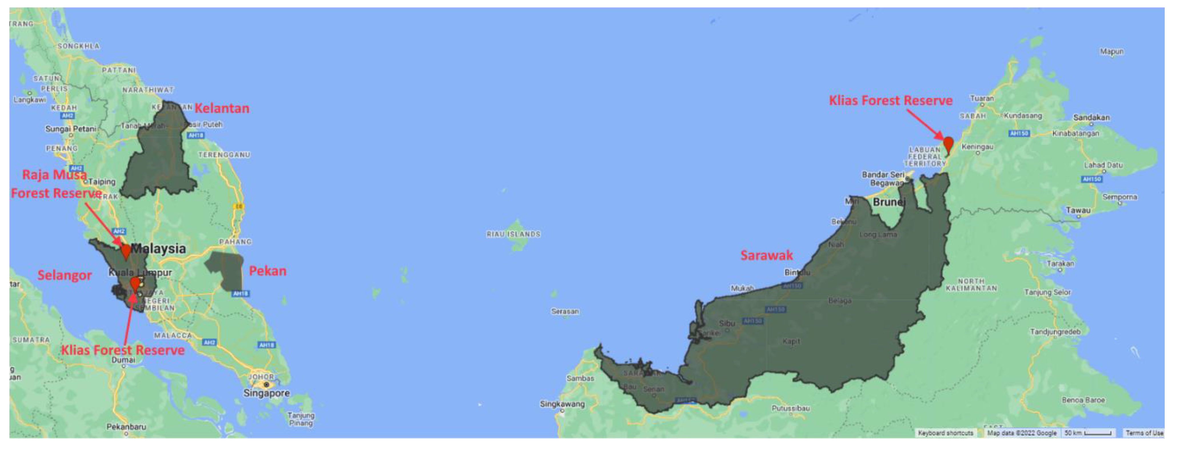
2.4. Hotspot Locations in Malaysia Based on Previous Studies
2.5. Factors Affecting Forest Fire in Malaysia
3. Type of Data Utilised for Forest Fire Risk Modelling in Malaysia

| Derived Product | Satellite Version/ Data Source | Previous Application | Accessibility |
|---|---|---|---|
| Land Cover or Fuel Type Normalized Burn Ratio (NBR) Normalized Difference Water Index (NDWI) Normalized Vegetation Index (NDVI) | Landsat Thematic Mapper (TM)—version not mentioned | [10,64,85] | Public [104] access from USGS Earth Explorer) |
| Landsat-5 TM | [11,83] | ||
| Landsat-7 ETM | [51,68,69,83,105] | ||
| Landsat 8 | [73] | ||
| Land Cover (classified) for Malaysia and Indonesia | Landsat 7 Enhanced Thematic Mapper (ETM) and Landsat 8 Operational Land Imager (OLI) [78,106] | [67] | Private (The classified land cover is not available publicly) |
| Precipitable Water Vapor for Relative Humidity | MODIS Level-1 (MACRES) | [48] | Public [107,108,109] |
| Land Surface Temperature Surface Air Temperature for Relative Humidity Precipitable Water for Relative Humidity | MODIS Level-2 | [61] | Public [110,111] |
| MODIS MCD14ML Collection 5 Active Fire (hotspots) | NASA’s Fire Information for Resource Management System | [67,71,74] | Public [112] |
| Land Surface Temperature | - | [52] | Public [113] |
| World Fire Atlas (hotspots) | - | [45,70] | Public [114] |
| Historical Forest Fire Data (hotspots) | AVHRR NOAA (not specified) | [64,81,85] | Public [115] |
| AVHRR NOAA 12 | [51,61,105] | ||
| AVHRR NOAA 16 | [51,61,105] | ||
| Application of Wildfire Biomass Burning Algorithm (Hotspots) | - | [67] | Public [116] |
| Type of Data | Derived Product | Data Source | Previous Application | Accessibility |
|---|---|---|---|---|
| Topography | Contour Administrative Boundaries Water Resources Settlement Transportation Infrastructure | Department of National Mapping and Survey (JUPEM) | [51,61,105] | Private (apply and pay) [117] Price List [118] |
| Digital Contours Digital Elevation Model Slope Gradient Slope Aspect | [11] | |||
| Aspect Elevation Slope | Not Mentioned | [10] | - | |
| - | Hotspots Prone Area Fire Occurrence Map Peat Swamp Map Soil Map | Malaysia Centre of Remote Sensing (MACRES) Known as Malaysia Space Agency (since 2019) | [51,61,105] | Private (apply and pay) [119] Price list [120] Local students/universities may request some data for free for research and educational purposes [119] Raw format of the relevant data (MODIS, NOAA, LANDSAT TM, and SPOT 1–5) can be obtained from Public MYSA archive data [121] |
| Population Data | Population Data Socio-economic Data | Department of Statistics Malaysia | [51,105] | Public/Available Data [122,123] Additional data requests can be sent to the Director of the Department of Statistics Malaysia |
| Meteorological Data | Temperature Relative Humidity Fire Danger Rating System (FDRS) | Malaysian Meteorological Services Department | [11,51,54,61,105] | Only the future 7-day forecasted weather data were made available in the official portal [124]. Archive data not available; contact Malaysia Meteorological department to request [125] |
| Daily Air Temperature Total Daily Rainfall | Malaysian Meteorological Services Department | [58] | ||
| Daily Weather Data | Temperature Relative Humidity Wind Speed | National Climatic Data Center | [45] | Public [126] |
| - | Land-use/cover maps | Department of Forestry and Department of Agriculture | [11] | Private (apply and pay) [127] |
| - | Record of Past Fire Occurrences/Forest Fire Reports | Forestry Department of Peninsular Malaysia (JPSM) | [11,51,61,105] | Not Available |
| An initiative by National Geospatial Centre Malaysia (G2G) [128] | Malaysia Government Unit/Local Public University in Malaysia can apply for free | National Geospatial Centre Malaysia | - | Private (requests can be sent to Malaysia Government Body and Malaysia Public University only) [128] |
3.1. Discussion on the Application of Data for Forest Fire Detection
Big Data Platform for Satellite Data
4. Global View of Machine Learning and Forest Fire
Deep Learning and Forest Fire
5. Challenges and Future Direction of Forest Fire Efforts in Malaysia
Open Research Questions
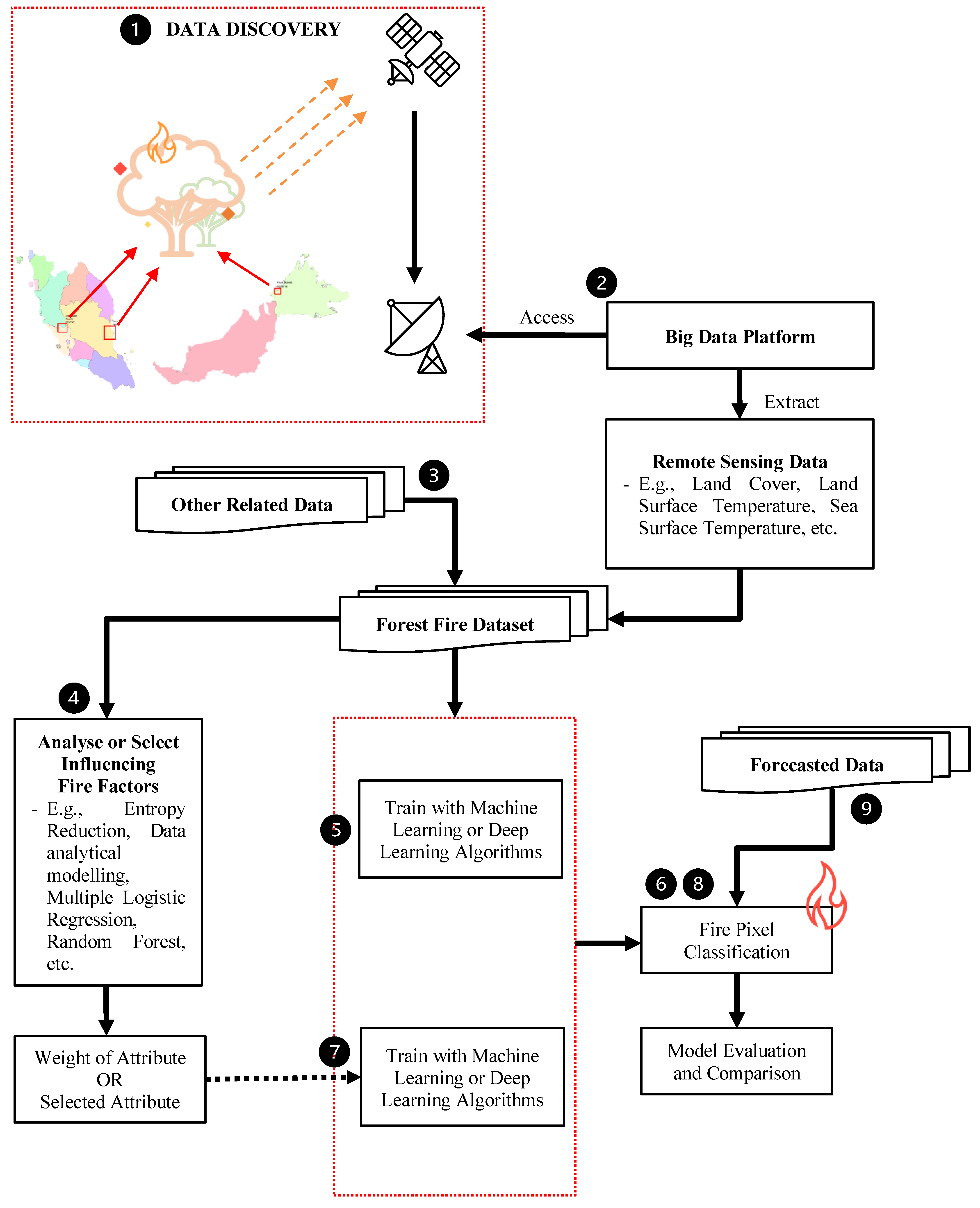
6. Proposed General Methodology to Utilise Remote Sensing Data for Forest Fire Efforts in Malaysia
7. Forest Fire Benchmark Datasets
Forest Fire Validation Data
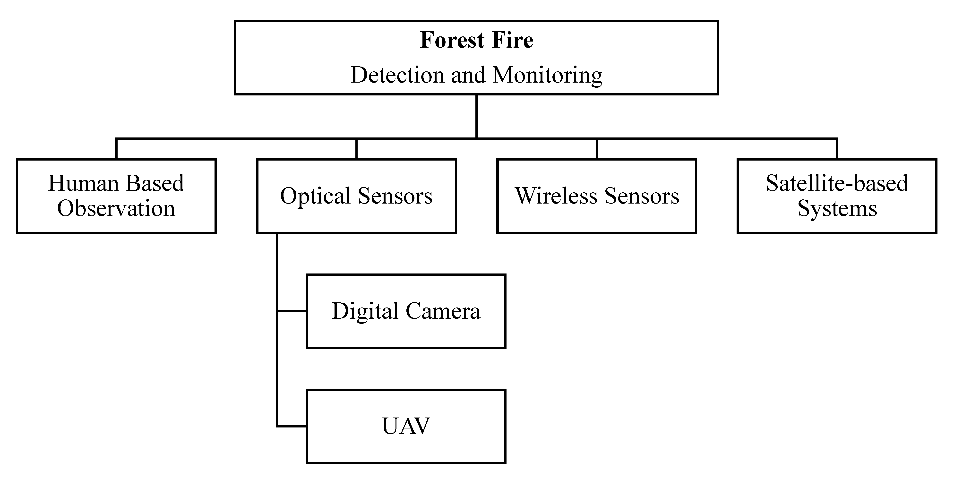
8. Overview of Forest Fire Detection and Monitoring
9. Other Relevant Studies Commonly Employed in Forest Fire Domain
10. Conclusions
Author Contributions
Funding
Data Availability Statement
Acknowledgments
Conflicts of Interest
References
- Stefanidis, S.; Alexandridis, V.; Spalevic, V.; Mincato, R.L. Wildfire Effects on Soil Erosion Dynamics: The Case of 2021 Megafires in Greece. Agric. For. 2022, 68, 49–63. [Google Scholar]
- Efthimiou, N.; Psomiadis, E.; Panagos, P. Fire Severity and Soil Erosion Susceptibility Mapping Using Multi-Temporal Earth Observation Data: The Case of Mati Fatal Wildfire in Eastern Attica, Greece. Catena 2020, 187, 104320. [Google Scholar] [CrossRef] [PubMed]
- Stefanidis, S.; Alexandridis, V.; Ghosal, K. Assessment of Water-Induced Soil Erosion as a Threat to Natura 2000 Protected Areas in Crete Island, Greece. Sustainability 2022, 14, 2738. [Google Scholar] [CrossRef]
- Köninger, J.; Panagos, P.; Jones, A.; Briones, M.J.I.; Orgiazzi, A. In Defence of Soil Biodiversity: Towards an Inclusive Protection in the European Union. Biol. Conserv. 2022, 268, 109475. [Google Scholar] [CrossRef]
- Goss, M.; Swain, D.L.; Abatzoglou, J.T.; Sarhadi, A.; Kolden, C.A.; Williams, A.P.; Diffenbaugh, N.S. Climate Change Is Increasing the Likelihood of Extreme Autumn Wildfire Conditions across California. Environ. Res. Lett. 2020, 15, 94016. [Google Scholar] [CrossRef]
- Radeloff, V.C.; Helmers, D.P.; Kramer, H.A.; Mockrin, M.H.; Alexandre, P.M.; Bar-Massada, A.; Butsic, V.; Hawbaker, T.J.; Martinuzzi, S.; Syphard, A.D. Rapid Growth of the US Wildland-Urban Interface Raises Wildfire Risk. Proc. Natl. Acad. Sci. USA 2018, 115, 3314–3319. [Google Scholar] [CrossRef]
- Buckland, M.K. What Is a Megafire? Defining the Social and Physical Dimensions of Extreme US Wildfires (1988–2014). Ph.D. Thesis, University of Colorado, Boulder, CO, USA, 2019. [Google Scholar]
- Abdullah, M.J.; Ibrahim, M.R.; Abdul Rahim, A.R. The Incidence of Forest Fire in Peninsular Malaysia: History, Root Causes, Prevention and Control. Prev. Control. Fire Peatl. 2002, 27–34. [Google Scholar]
- Chandrasekharan, C. The Mission on Forest Fire Prevention and Management to Indonesia and Malaysia (Sarawak). Trop. For. Fire. Prev. Control. Rehabil. Trans-Bound. Issues 1998, 14, 1–79. [Google Scholar]
- Setiawan, I.; Mahmud, A.R.; Mansor, S.; Shariff, A.R.M.; Nuruddin, A.A. GIS-grid-based and Multi-criteria Analysis for Identifying and Mapping Peat Swamp Forest Fire Hazard in Pahang, Malaysia. Disaster Prev. Manag. An. Int. J. 2004, 13, 379–386. [Google Scholar] [CrossRef]
- Patah, N.A.; Mansor, S.; Mispan, M.R. An Application of Remote Sensing and Geographic Information System for Forest Fire Risk Mapping. Malays. Cent. Remote Sens. 2006, 54–67. [Google Scholar]
- Bernama 80 Hektar Hutan Simpan Kuala Langat Terbakar. Available online: https://www.bharian.com.my/berita/kes/2020/04/679541/80-hektar-hutan-simpan-kuala-langat-terbakar (accessed on 2 August 2021).
- Bernama Lebih 40 Hektar Hutan Simpan Kuala Langat Selatan Terbakar. Available online: https://www.bharian.com.my/berita/nasional/2021/03/791876/lebih-40-hektar-hutan-simpan-kuala-langat-selatan-terbakar (accessed on 2 August 2021).
- Berita Harian Kegiatan Memancing Disyaki Punca Kebakaran Hutan. Available online: https://www.bharian.com.my/berita/wilayah/2020/03/670625/kegiatan-memancing-disyaki-punca-kebakaran-hutan (accessed on 2 August 2021).
- Tang, K.H.D. Climate Change in Malaysia: Trends, Contributors, Impacts, Mitigation and Adaptations. Sci. Total Environ. 2019, 650, 1858–1871. [Google Scholar] [CrossRef]
- Alagesh, T.N. 40 ha of Pahang Forest, Peat Land on Fire. New Straits Times, 26 February 2019. Available online: https://www.nst.com.my/news/nation/2019/02/463995/40ha-pahang-forest-peat-land-fire-nsttv(accessed on 28 August 2022).
- Then, S. Forest Fires Flare up Again in Parts of Sarawak. The Star. 17 July 2019. Available online: https://www.thestar.com.my/news/nation/2019/07/17/forest-fires-flare-up-again-in-parts-of-sarawak (accessed on 28 August 2022).
- Tay, R. The Haze Is Making a Comeback in August, and Some Malaysian Regions Are Already Affected. 2 August 2019. Available online: https://web.archive.org/web/20190823091814/https://www.businessinsider.my/the-haze-is-making-a-comeback-in-august-and-some-malaysian-regions-are-already-affected/ (accessed on 28 August 2022).
- Then, S. More Hotspots in Kalimantan May Bring Widespread Transboundary Haze to S’wak. The Star. 18 August 2019. Available online: https://www.thestar.com.my/news/nation/2019/08/18/more-hotspots-in-kalimantan-may-bring-widespread-transboundary-haze-to-s039wak (accessed on 28 August 2022).
- Beaman, R.S.; Beaman, J.H.; Marsh, C.W.; Woods, P. V Drought and Forest Fires in Sabah in 1983. Sabah Soc. J. 1985, 8, 10–30. [Google Scholar]
- Woods, P. Effects of Logging, Drought, and Fire on Structure and Composition of Tropical Forests in Sabah, Malaysia. Biotropica 1989, 21, 290–298. [Google Scholar] [CrossRef]
- Cane, M.A. Oceanographic Events during El Nino. Science 1983, 222, 1189–1195. [Google Scholar] [CrossRef]
- Abid, F. A Survey of Machine Learning Algorithms Based Forest Fires Prediction and Detection Systems. Fire Technol. 2020, 57, 559–590. [Google Scholar] [CrossRef]
- Bot, K.; Borges, J.G. A Systematic Review of Applications of Machine Learning Techniques for Wildfire Management Decision Support. Inventions 2022, 7, 15. [Google Scholar] [CrossRef]
- Chuvieco, E.; Salas, J. Mapping the Spatial Distribution of Forest Fire Danger Using GIS. Int. J. Geogr. Inf. Sci. 1996, 10, 333–345. [Google Scholar] [CrossRef]
- Cochrane, M.A. Fire Science for Rainforests. Nature 2003, 421, 913–919. [Google Scholar] [CrossRef]
- Gomes, V.C.F.; Queiroz, G.R.; Ferreira, K.R. An Overview of Platforms for Big Earth Observation Data Management and Analysis. Remote Sens. 2020, 12, 1253. [Google Scholar] [CrossRef]
- Killough, B. Overview of the Open Data Cube Initiative. In Proceedings of the IGARSS 2018—2018 IEEE International Geoscience and Remote Sensing Symposium, Valencia, Spain, 23 July 2018; pp. 8629–8632. [Google Scholar]
- Gorelick, N.; Hancher, M.; Dixon, M.; Ilyushchenko, S.; Thau, D.; Moore, R. Google Earth Engine: Planetary-Scale Geospatial Analysis for Everyone. Remote Sens. Environ. 2017, 202, 18–27. [Google Scholar] [CrossRef]
- Microsoft Planetary Computer. Available online: https://planetarycomputer.microsoft.com/ (accessed on 24 January 2022).
- Joseph, S.; Anitha, K.; Murthy, M.S.R. Forest Fire in India: A Review of the Knowledge Base. J. For. Res. 2009, 14, 127–134. [Google Scholar] [CrossRef]
- Alkhatib, A.A.A. A Review on Forest Fire Detection Techniques. Int. J. Distrib. Sens. Netw. 2014, 2014, 597368. [Google Scholar] [CrossRef]
- Yuan, C.; Zhang, Y.; Liu, Z. A Survey on Technologies for Automatic Forest Fire Monitoring, Detection, and Fighting Using Unmanned Aerial Vehicles and Remote Sensing Techniques. Can. J. For. Res. 2015, 45, 783–792. [Google Scholar] [CrossRef]
- Ministry of Environment and Water Air Pollutant Index (API). Available online: https://www.doe.gov.my/portalv1/en/info-umum/english-air-pollutant-index-api/100 (accessed on 3 March 2021).
- Musa, S.; Parlan, I. The 1997/98 Forest Fire Experience in Peninsular Malaysia. Prev. Control Fire Peatl. 2002, 69–74. [Google Scholar]
- Diemont, W.H.; Hillegers, P.J.M.; Joosten, H.; Kramer, K.; Ritzema, H.P.; Rieley, J.; Wösten, J.H.M. Fire and Peat Forests, What Are the Solutions? In Proceedings of the Workshop on Prevention & Control of Fire in Peatlands, Kuala Lumpur, Malaysia, 19 March 2002; pp. 41–50. [Google Scholar]
- Schott, J.R. Remote Sensing: The Image Chain Approach, 2nd ed.; Oxford University Press on Demand: Oxford, UK, 2007. [Google Scholar]
- Chuvieco, E.; Congalton, R.G. Application of Remote Sensing and Geographic Information Systems to Forest Fire Hazard Mapping. Remote Sens. Environ. 1989, 29, 147–159. [Google Scholar] [CrossRef]
- Clarke, K.C. Advances in Geographic Information Systems. Comput. Environ. Urban Syst. 1986, 10, 175–184. [Google Scholar] [CrossRef]
- Esri Introducing ArcGIS Platform|Esri. Available online: https://www.esri.com/en-us/home (accessed on 13 March 2021).
- QGIS Development Team Welcome to the QGIS Project! Available online: https://www.qgis.org/en/site/ (accessed on 13 March 2021).
- Dymond, C.C.; Roswintiarti, O.; Brady, M. Characterizing and Mapping Fuels for Malaysia and Western Indonesia. Int. J. Wildl. Fire 2004, 13, 323–334. [Google Scholar] [CrossRef]
- Stibig, H.; Belward, A.S.; Roy, P.S.; Rosalina-Wasrin, U.; Agrawal, S.; Joshi, P.K.; Hildanus; Beuchle, R.; Fritz, S.; Mubareka, S. A Land-cover Map for South and Southeast Asia Derived from SPOT-VEGETATION Data. J. Biogeogr. 2007, 34, 625–637. [Google Scholar] [CrossRef]
- DeFries, R.S.; Townshend, J.R.G.; Hansen, M.C. Continuous Fields of Vegetation Characteristics at the Global Scale at 1-km Resolution. J. Geophys. Res. Atmos. 1999, 104, 16911–16923. [Google Scholar] [CrossRef]
- Dymond, C.C.; Field, R.D.; Roswintiarti, O. Using Satellite Fire Detection to Calibrate Components of the Fire Weather Index System in Malaysia and Indonesia. Environ. Manag. 2005, 35, 426–440. [Google Scholar] [CrossRef]
- Stocks, B.J.; Lynham, T.J.; Lawson, B.D.; Alexander, M.E.; Van Wagner, C.E.; McAlpine, R.S.; Dube, D.E. Canadian Forest Fire Danger Rating System: An Overview. For. Chron. 1989, 65, 258–265. [Google Scholar] [CrossRef]
- Arino, O.; Melinotte, J.M. Fire Index Atlas. Earth Obs. Q. 1995, 50, 11–16. [Google Scholar]
- Peng, G.; Li, J.; Chen, Y.; Norizan, A.P.; Tay, L. High-Resolution Surface Relative Humidity Computation Using MODIS Image in Peninsular Malaysia. Chin. Geogr. Sci. 2006, 16, 260–264. [Google Scholar] [CrossRef]
- Han, K.-S.; Viau, A.A.; Anctil, F. High-Resolution Forest Fire Weather Index Computations Using Satellite Remote Sensing. Can. J. For. Res. 2003, 33, 1134–1143. [Google Scholar] [CrossRef]
- Anderson, I.P.; Imanda, I.D.; Balai, M.; Dan, I.; Hutan, P.; Ii, W.; Kehutanan, K.; Perkebunan, D. Vegetation Fires in Sumatra, Indonesia: The Presentation and Distribution of NOAA Derived Data. In Forest Fire Prevention and Control Project; Natural Resources International Ltd. Scot Conseil: Jakarta, Indonesia, 1999. [Google Scholar]
- Pradhan, B.; Suliman, M.D.H.B.; Awang, M.A. Bin Forest Fire Susceptibility and Risk Mapping Using Remote Sensing and Geographical Information Systems (GIS). Disaster Prev. Manag. 2007, 16, 344–352. [Google Scholar] [CrossRef]
- Peng, G.-X.; Jing, L.; Chen, Y.-H.; Norizan, A.-P. A Forest Fire Risk Assessment Using ASTER Images in Peninsular Malaysia. J. China Univ. Min. Technol. 2007, 17, 232–237. [Google Scholar] [CrossRef]
- Dasgupta, S.; Qu, J.J.; Hao, X. Design of a Susceptibility Index for Fire Risk Monitoring. IEEE Geosci. Remote Sens. Lett. 2006, 3, 140–144. [Google Scholar] [CrossRef]
- De Groot, W.J.; Field, R.D.; Brady, M.A.; Roswintiarti, O.; Mohamad, M. Development of the Indonesian and Malaysian Fire Danger Rating Systems. Mitig. Adapt. Strateg. Glob. Chang. 2007, 12, 165. [Google Scholar] [CrossRef]
- Malaysia Meteorological Department Sistem Risiko Bahaya Kebakaran (FDRS) Malaysia. Available online: https://www.met.gov.my/iklim/fdrs/mfdrs (accessed on 9 March 2021).
- Malaysia Meteorological Department Sistem Risiko Bahaya Kebakaran (FDRS) ASEAN. Available online: https://www.met.gov.my/iklim/fdrs/afdrs?lang=bm (accessed on 9 March 2021).
- Rieley, J.; Page, S. Tropical Peatland of the World. In Tropical Peatland Ecosystems; Springer: Berlin/Heidelberg, Germany, 2016; pp. 3–32. [Google Scholar]
- Ainuddin, N.A.; Ampun, J. Temporal Analysis of the Keetch-Byram Drought Index in Malaysia: Implications for Forest Fire Management. J. Appl. Sci. 2008, 8, 3991–3994. [Google Scholar] [CrossRef]
- Keetch, J.J.; Byram, G.M. A Drought Index for Forest Fire Control; US Department of Agriculture, Forest Service, Southeastern Forest Experiment: Asheville, NC, USA, 1968; Volume 38. [Google Scholar]
- Finkele, K.; Mills, G.A.; Beard, G.; Jones, D.A. National Gridded Drought Factors and Comparison of Two Soil Moisture Deficit Formulations Used in Prediction of Forest Fire Danger Index in Australia. Aust. Meteorol. Mag. 2006, 55, 183–197. [Google Scholar]
- Pradhan, B. Hot Spot Detection and Monitoring Using MODIS and NOAA AVHRR Images for Wild Fire Emergency Preparedness. In Proceedings of the 2nd Applied Geoinformatics for Society and Environment (AGSE) Conference, Stuttgart Technology University of Applied Sciences, Stuttgart, Germany, 12–17 July 2009; pp. 53–61. [Google Scholar]
- Mahmud, A.; Setiawan, I.; Mansor, S.; Shariff, A.; Pradhan, B.; Nuruddin, A. Utilization of Geoinformation Tools for the Development of Forest Fire Hazard Mapping System: Example of Pekan Fire, Malaysia. Open Geosci. 2009, 1, 456–462. [Google Scholar] [CrossRef]
- Saaty, T.L. How to Make a Decision: The Analytic Hierarchy Process. Eur. J. Oper. Res. 1990, 48, 9–26. [Google Scholar] [CrossRef]
- Razali, S.M.; Nuruddin, A.A.; Malek, I.A.; Patah, N.A. Forest Fire Hazard Rating Assessment in Peat Swamp Forest Using Landsat Thematic Mapper Image. J. Appl. Remote Sens. 2010, 4, 43531. [Google Scholar] [CrossRef]
- Ramsey, E.W.; Hodgson, M.E.; Sapkota, S.K.; Nelson, G.A. Forest Impact Estimated with NOAA AVHRR and Landsat TM Data Related to an Empirical Hurricane Wind-Field Distribution. Remote Sens. Environ. 2001, 77, 279–292. [Google Scholar] [CrossRef]
- Ismail, P.; Shamsudin, I.; Khali Aziz, H. Development of Indicators for Assessing Susceptibility of Degraded Peatland Areas to Forest Fires in Peninsular Malaysia. IUFRO World Ser. 2011, 29, 67. [Google Scholar]
- Hyer, E.J.; Reid, J.S.; Prins, E.M.; Hoffman, J.P.; Schmidt, C.C.; Miettinen, J.I.; Giglio, L. Patterns of Fire Activity over Indonesia and Malaysia from Polar and Geostationary Satellite Observations. Atmos. Res. 2013, 122, 504–519. [Google Scholar] [CrossRef]
- Suliman, M.D.H.; Mahmud, M.; Reba, M.N.M. Mapping and Analysis of Forest and Land Fire Potential Using Geospatial Technology and Mathematical Modeling. IOP Conf. Ser. Earth Environ. Sci. 2014, 18, 12034. [Google Scholar] [CrossRef]
- Mohd, D.; Mastura, M. Analysis of Potential Forest Fires by Utilizing Geospatial and AHP Model in Selangor, Malaysia. Sains Malays. 2013, 42, 579–586. [Google Scholar]
- Ash’aari, Z.H.; Badrunsham, A.S. Spatial Temporal Analysis of Forest Fire in Malaysia Using ATSR Satellite Measurement. Bull. Environ. Sci. Sustain. Manag. 2014, 2, 8–11. [Google Scholar] [CrossRef]
- Leewe, Y.; Ahmad, A.N.; Ismail, A.; Sheriza, M.R. Analysis of Hotspot Pattern Distribution at Sabah, Malaysia for Forest Fire Management. J. Environ. Sci. Technol. 2016, 9, 291–295. [Google Scholar]
- Davies, D.K.; Ilavajhala, S.; Wong, M.M.; Justice, C.O. Fire Information for Resource Management System: Archiving and Distributing MODIS Active Fire Data. IEEE Trans. Geosci. Remote Sens. 2008, 47, 72–79. [Google Scholar] [CrossRef]
- Bin Jamaruppin, M.E.; Bayuaji, L.; Ab Ghani, N.B.; Rahman, M.A.; Akashah, F.W.; Shah, A. Forest Fire Occurrence Analysis Base on Land Brightness Temperature Using Landsat Data (Study Area: Jalan Kuantan–Pekan, Pahang, Malaysia). In Proceedings of the National Conference for Postgraduate Research, University Malaysia Pahang, Pekan, Malaysia, 24–25 September 2016; pp. 798–805. [Google Scholar]
- Miettinen, J.; Shi, C.; Liew, S.C. Fire Distribution in Peninsular Malaysia, Sumatra and Borneo in 2015 with Special Emphasis on Peatland Fires. Environ. Manag. 2017, 60, 747–757. [Google Scholar] [CrossRef]
- Tacconi, L. Preventing Fires and Haze in Southeast Asia. Nat. Clim. Chang. 2016, 6, 640–643. [Google Scholar] [CrossRef]
- Field, R.D.; Van Der Werf, G.R.; Fanin, T.; Fetzer, E.J.; Fuller, R.; Jethva, H.; Levy, R.; Livesey, N.J.; Luo, M.; Torres, O. Indonesian Fire Activity and Smoke Pollution in 2015 Show Persistent Nonlinear Sensitivity to El Niño-Induced Drought. Proc. Natl. Acad. Sci. USA 2016, 113, 9204–9209. [Google Scholar] [CrossRef]
- Huijnen, V.; Wooster, M.J.; Kaiser, J.W.; Gaveau, D.L.A.; Flemming, J.; Parrington, M.; Inness, A.; Murdiyarso, D.; Main, B.; van Weele, M. Fire Carbon Emissions over Maritime Southeast Asia in 2015 Largest since 1997. Sci. Rep. 2016, 6, 26886. [Google Scholar]
- Miettinen, J.; Shi, C.; Liew, S.C. Land Cover Distribution in the Peatlands of Peninsular Malaysia, Sumatra and Borneo in 2015 with Changes since 1990. Glob. Ecol. Conserv. 2016, 6, 67–78. [Google Scholar] [CrossRef]
- Biancalani, R.; Avagyan, A. Towards Climate-Responsible Peatlands Management. Mitig. Clim. Chang. Agric. Ser. 2014, 9, 1–117. [Google Scholar]
- Indonesia Meteorological Climatological and Geophysical Agency Sistem Peringatan Kebakaran Hutan Dan Lahan|BMKG. Available online: https://www.bmkg.go.id/cuaca/kebakaran-hutan.bmkg?index=fwi&wil=indonesia&day=obs (accessed on 14 March 2021).
- Mahmud, M. Active Fire and Hotspot Emissions in Peninsular Malaysia during the 2002 Burning Season. Geogr. J. Soc. Sp. 2005, 1, 32–45. [Google Scholar]
- Joyner, W.M. Compilation of Air-Pollutant Emission Factors, Volume 1, Stationary Point and Area Sources, Fourth Edition, Supplement C. United States; Environmental Protection Agency: Washington, DC, USA, 1 September 1990. [Google Scholar]
- Phua, M.-H.; Tsuyuki, S.; Lee, J.S.; Sasakawa, H. Detection of Burned Peat Swamp Forest in a Heterogeneous Tropical Landscape: A Case Study of the Klias Peninsula, Sabah, Malaysia. Landsc. Urban Plan. 2007, 82, 103–116. [Google Scholar] [CrossRef]
- Ainuddin, N.A.; Goh, K. Effect of Forest Fire on Stand Structure in Raja Musa Peat Swamp Forest Reserve, Selangor, Malaysia. J. Environ. Sci. Technol. 2010, 3, 56–62. [Google Scholar] [CrossRef]
- Bin Suliman, M.D.H.; Serra, J.; Mahmud, M. Prediction and Simulation of Malaysian Forest Fires by Random Spread. Int. J. Remote Sens. 2010, 31, 6015–6032. [Google Scholar] [CrossRef]
- Serra, J. The Random Spread Model. Complex Anal. Digit. Geom. 2006, 283–310. [Google Scholar]
- Sahani, M.; Zainon, N.A.; Mahiyuddin, W.R.W.; Latif, M.T.; Hod, R.; Khan, M.F.; Tahir, N.M.; Chan, C.-C. A Case-Crossover Analysis of Forest Fire Haze Events and Mortality in Malaysia. Atmos. Environ. 2014, 96, 257–265. [Google Scholar] [CrossRef]
- Fisal, N.S.M.; Lintangah, W.; Ismenyah, M. Community Awareness & Challenges in Forest Fire Prevention: A Case Study at Peat Swamp Forest, Klias Forest Reserve, Beaufort, Sabah, Malaysia. Int. J. Agric. For. Plant. 2017, 5, 86–91. [Google Scholar]
- Smith, T.E.L.; Evers, S.; Yule, C.M.; Gan, J.Y. In Situ Tropical Peatland Fire Emission Factors and Their Variability, as Determined by Field Measurements in Peninsula Malaysia. Glob. Biogeochem. Cycles 2018, 32, 18–31. [Google Scholar] [CrossRef]
- Musri, I.; Ainuddin, A.N.; Hyrul, M.H.I.; Hazandy, A.H.; Azani, A.M.; Mitra, U. Post Forest Fire Management at Tropical Peat Swamp Forest: A Review of Malaysian Experience on Rehabilitation and Risk Mitigation. IOP Conf. Ser. Earth Environ. Sci. 2020, 504, 12017. [Google Scholar] [CrossRef]
- Parish, F.; Lew, S.Y.S.; Mohd Hassan, A.H. National Strategies on Responsible Management of Tropical Peatland in Malaysia. In Tropical Peatland Eco-Management; Springer: Berlin/Heidelberg, Germany, 2021; pp. 677–723. [Google Scholar]
- Sali, A.; Mohd Ali, A.; Ali, B.M.; Syed Ahmad Abdul Rahman, S.M.; Liew, J.T.; Saleh, N.L.; Nuruddin, A.A.; Mohd Razali, S.; Nsaif, I.G.; Ramli, N. Peatlands Monitoring in Malaysia with IoT Systems: Preliminary Experimental Results. In Proceedings of the International Conference on Computational Intelligence in Information System, Bandar Seri Begawan, Berunei Darussalam, Brunei, 25–27 January 2021; Springer: Berlin/Heidelberg, Germany, 2021; pp. 233–242. [Google Scholar]
- Astro Awani Kebakaran Hutan Simpan Pekan Tak Membimbangkan (Fire in Pekan Forest Reserve Is Not a Concern). Available online: https://www.astroawani.com/berita-malaysia/kebakaran-hutan-simpan-pekan-tak-membimbangkan-186979 (accessed on 2 August 2021).
- Awang, A. Lebih 300 Hektar Hutan Di Pahang Terbakar (More Than 300 Hectare of Forest Burnt in Pahang). Available online: https://www.bharian.com.my/berita/wilayah/2021/03/795145/lebih-300-hektar-hutan-di-pahang-terbakar (accessed on 2 August 2021).
- Bernama Kebakaran Hutan Simpan Pekan: Anggota Bomba, Jabatan Perhutanan Terkandas (Fire in Pekan Forest Reserve: Fire Fighters, Forestry Department Is Stranded). Available online: https://www.utusanborneo.com.my/2018/10/01/kebakaran-hutan-simpan-pekan-anggota-bomba-jabatan-perhutanan-terkandas (accessed on 2 August 2021).
- Malaysia Kini Hutan Seluas 34 Hektar Terbakar Di Kuantan (A 34-Hectare Forest Burned in Kuantan). Available online: https://www.malaysiakini.com/news/339616 (accessed on 2 August 2021).
- Muhammad, A. 994 Kes Kebakaran Terbuka Di Selangor Sejak Januari. Available online: https://www.sinarharian.com.my/article/125841/BERITA/Semasa/994-kes-kebakaran-terbuka-di-Selangor-sejak-Januari (accessed on 2 August 2021).
- Idris, M.N. Kebakaran Hutan Di Selangor Meningkat—Utusan Digital. Available online: https://www.utusan.com.my/berita/2020/07/kebakaran-hutan-di-selangor-meningkat/ (accessed on 2 August 2021).
- Utusan Borneo Pasukan Kru Api JPS Bertungkus-Lumus Padam Kebakaran Hutan Simpan Binsuluk|Utusan Borneo Online. Available online: https://www.utusanborneo.com.my/2020/03/29/pasukan-kru-api-jps-bertungkus-lumus-padam-kebakaran-hutan-simpan-binsuluk (accessed on 2 August 2021).
- Berita Harian Kualiti Udara Pantai Barat Sabah Semakin Pulih. Available online: https://www.bharian.com.my/berita/nasional/2016/04/141727/kualiti-udara-pantai-barat-sabah-semakin-pulih (accessed on 2 August 2021).
- Ganteaume, A.; Camia, A.; Jappiot, M.; San-Miguel-Ayanz, J.; Long-Fournel, M.; Lampin, C. A Review of the Main Driving Factors of Forest Fire Ignition over Europe. Environ. Manag. 2013, 51, 651–662. [Google Scholar] [CrossRef]
- Ban, Y.; Zhang, P.; Nascetti, A.; Bevington, A.R.; Wulder, M.A. Near Real-Time Wildfire Progression Monitoring with Sentinel-1 SAR Time Series and Deep Learning. Sci. Rep. 2020, 10, 1322. [Google Scholar] [CrossRef] [PubMed]
- Gibson, R.; Danaher, T.; Hehir, W.; Collins, L. A Remote Sensing Approach to Mapping Fire Severity in South-Eastern Australia Using Sentinel 2 and Random Forest. Remote Sens. Environ. 2020, 240, 111702. [Google Scholar] [CrossRef]
- United States Geological Survey Earth Explorer. Available online: https://earthexplorer.usgs.gov/ (accessed on 3 April 2021).
- Pradhan, B.; Awang, M.A. Application of Remote Sensing and Gis for Forest Fire Susceptibility Mapping Using Likelihood Ratio Model. Proc. Map Malaysia 2007, 16, 344–352. [Google Scholar]
- Miettinen, J.; Liew, S.C. Degradation and Development of Peatlands in Peninsular Malaysia and in the Islands of Sumatra and Borneo since 1990. Land Degrad. Dev. 2010, 21, 285–296. [Google Scholar] [CrossRef]
- NASA LAADS DAAC (Archive). Available online: https://ladsweb.modaps.eosdis.nasa.gov/archive/ (accessed on 3 April 2021).
- NASA Find Data—LAADS DAAC. Available online: https://ladsweb.modaps.eosdis.nasa.gov/search/ (accessed on 3 April 2021).
- NASA LP DAAC (MODIS Download). Available online: https://e4ftl01.cr.usgs.gov/MOLA/ (accessed on 3 April 2021).
- NASA MODIS Web. Available online: https://modis.gsfc.nasa.gov/data/dataprod/ (accessed on 3 April 2021).
- NASA Moderate Resolution Imaging Spectroradiometer (MODIS)|Earthdata. Available online: https://earthdata.nasa.gov/earth-observation-data/near-real-time/download-nrt-data/modis-nrt (accessed on 3 April 2021).
- Fire Information for Resource Management System Archive Download—NASA|LANCE|FIRMS. Available online: https://firms.modaps.eosdis.nasa.gov/download/ (accessed on 1 April 2021).
- NASA/METI/AIST/Japan Spacesystems and U.S./Japan ASTER Science Team ASTER Level 2 Surface Temperature Product [Data Set]. Available online: http://lpdaac.usgs.gov/products/ast_08v003/ (accessed on 28 August 2022).
- European Space Agency ATSR World Fire Atlas. Available online: http://due.esrin.esa.int/page_wfa.php (accessed on 3 April 2021).
- Asean Specialised Meteorological Centre (ASMC) VIIRS Hotspot—Annual. Available online: http://asmc.asean.org/asmc-haze-hotspot-annual-new#Hotspot (accessed on 4 April 2021).
- Cooperative Institute for Meteorological Satellite Studies Wildfire Automated Biomass Burning Algorithm (WFABBA). Available online: http://wfabba.ssec.wisc.edu/index.html (accessed on 4 April 2021).
- JUPEM Permohonan Lesen Hak Cipta/Membeli Dokumen Geospatial Terperingkat. 2021. Available online: https://www.jupem.gov.my/jupem18a/assets/uploads/images/contents/20220406103724-6ad21-borang-1_edit.pdf (accessed on 28 August 2022).
- JUPEM Information Mapping Data Rate (Fi Act 1951: Fees and Payments (Services, Survey and Mapping Data and Reproduction)). 2010. Available online: https://www.jupem.gov.my/page/national-mapping-spatial-data-committee-jpdsn-1 (accessed on 28 August 2022).
- MYSA Remote Sensing Data Application Procedure—Malaysian Space Agency (MYSA). Available online: http://www.mysa.gov.my/remote-sensing-data-application-procedure/ (accessed on 5 April 2021).
- MYSA Remote Sensing Satellite Data Price List—Malaysian Space Agency (MYSA). Available online: http://www.mysa.gov.my/remote-sensing-satellite-data-price-list/ (accessed on 5 April 2021).
- MYSA MYSA|MYSA Free Satellites Data. Available online: http://rsopendata.mysa.gov.my/mrsa_ctlg_dld.php (accessed on 5 April 2021).
- Malaysia Government Portal Data Terbuka (One Stop Center for Public Data). Available online: https://www.data.gov.my/ (accessed on 5 April 2021).
- Department of Statistics Malaysia Department of Statistics Malaysia Open Data. Available online: https://www.dosm.gov.my/v1/index.php?r=column3/accordion&menu_id=amZNeW9vTXRydTFwTXAxSmdDL1J4dz09 (accessed on 5 April 2021).
- Malaysia Meteorological Department MetMalaysia: Ramalan Cuaca Negeri. Available online: https://www.met.gov.my/forecast/weather/state?lang=en (accessed on 6 April 2021).
- Malaysian Meteorological Department Malaysian Meteorological Department Web Service API. Available online: https://api.met.gov.my/ (accessed on 5 April 2021).
- National Centers for Environmental Information Daily Weather Records|Data Tools|Climate Data Online (CDO)|National Climatic Data Center (NCDC). Available online: https://www.ncdc.noaa.gov/cdo-web/datatools/records (accessed on 5 April 2021).
- Department of Agriculture Application of Map/Stage Geospatial Document. Available online: http://www.doa.gov.my/index.php/pages/view/361 (accessed on 5 April 2021).
- National Geospatial Centre Malaysia Prosedur Permohonan Data Geospatial|MyGeoportal. Available online: http://www.mygeoportal.gov.my/ms/prosedur-permohonan-data-geospatial (accessed on 5 April 2021).
- Soille, P.; Burger, A.; De Marchi, D.; Kempeneers, P.; Rodriguez, D.; Syrris, V.; Vasilev, V. A Versatile Data-Intensive Computing Platform for Information Retrieval from Big Geospatial Data. Futur. Gener. Comput. Syst. 2018, 81, 30–40. [Google Scholar] [CrossRef]
- Pebesma, E.; Wagner, W.; Schramm, M.; Von Beringe, A.; Paulik, C.; Neteler, M.; Reiche, J.; Verbesselt, J.; Dries, J.; Goor, E.; et al. OpenEO—A Common, Open Source Interface Between Earth Observation Data Infrastructures and Front-End Applications; European Commission: Viena, Austria, 2017; Volume 57. [Google Scholar]
- Wang, L.; Ma, Y.; Yan, J.; Chang, V.; Zomaya, A.Y. PipsCloud: High Performance Cloud Computing for Remote Sensing Big Data Management and Processing. Futur. Gener. Comput. Syst. 2018, 78, 353–368. [Google Scholar] [CrossRef]
- United Nations Food and Agriculture Organization Sepal Repository. Available online: https://github.com/openforis/sepal (accessed on 19 July 2021).
- Sinergise Sentinel Hub. Available online: https://www.sentinel-hub.com/ (accessed on 19 July 2021).
- Chew, Y.J.; Ooi, S.Y.; Pang, Y.H. Data Acquisition Guide for Forest Fire Risk Modelling in Malaysia. In Proceedings of the 2021 9th International Conference on Information and Communication Technology (ICoICT), Yogyakarta, Indonesia, 3–5 August 2021; pp. 633–638. [Google Scholar] [CrossRef]
- Cortez, P.; Morais, A. A Data Mining Approach to Predict Forest Fires Using Meteorological Data. In Proceedings of the New Trends in Artificial Intelligence, 13th EPIA 2007, Portugese Conference on Artificial Intelligence, Guimaraes, Portugal, 3–7 December 2007; pp. 512–523. [Google Scholar]
- Maeda, E.E.; Formaggio, A.R.; Shimabukuro, Y.E.; Arcoverde, G.F.B.; Hansen, M.C. Predicting Forest Fire in the Brazilian Amazon Using MODIS Imagery and Artificial Neural Networks. Int. J. Appl. Earth Obs. Geoinf. 2009, 11, 265–272. [Google Scholar] [CrossRef]
- Cheney, N.P.; Gould, J.S.; McCaw, W.L.; Anderson, W.R. Predicting Fire Behaviour in Dry Eucalypt Forest in Southern Australia. For. Ecol. Manag. 2012, 280, 120–131. [Google Scholar] [CrossRef]
- Pham, B.T.; Jaafari, A.; Avand, M.; Al-Ansari, N.; Dinh Du, T.; Yen, H.P.H.; Van Phong, T.; Nguyen, D.H.; Van Le, H.; Mafi-Gholami, D. Performance Evaluation of Machine Learning Methods for Forest Fire Modeling and Prediction. Symmetry 2020, 12, 1022. [Google Scholar] [CrossRef]
- Stojanova, D.; Panov, P.; Kobler, A.; Džeroski, S.; Taškova, K. Learning to Predict Forest Fires with Different Data Mining Techniques. In Proceedings of the Conference on Data Mining and Data Warehouses (SiKDD 2006), Ljubljana, Slovenia, 17 October 2006; pp. 255–258. [Google Scholar]
- Bui, D.T.; Bui, Q.-T.; Nguyen, Q.-P.; Pradhan, B.; Nampak, H.; Trinh, P.T. A Hybrid Artificial Intelligence Approach Using GIS-Based Neural-Fuzzy Inference System and Particle Swarm Optimization for Forest Fire Susceptibility Modeling at a Tropical Area. Agric. For. Meteorol. 2017, 233, 32–44. [Google Scholar]
- Bui, D.T.; Hoang, N.-D.; Samui, P. Spatial Pattern Analysis and Prediction of Forest Fire Using New Machine Learning Approach of Multivariate Adaptive Regression Splines and Differential Flower Pollination Optimization: A Case Study at Lao Cai Province (Viet Nam). J. Environ. Manag. 2019, 237, 476–487. [Google Scholar]
- Monjarás-Vega, N.A.; Briones-Herrera, C.I.; Vega-Nieva, D.J.; Calleros-Flores, E.; Corral-Rivas, J.J.; López-Serrano, P.M.; Pompa-García, M.; Rodríguez-Trejo, D.A.; Carrillo-Parra, A.; González-Cabán, A. Predicting Forest Fire Kernel Density at Multiple Scales with Geographically Weighted Regression in Mexico. Sci. Total Environ. 2020, 718, 137313. [Google Scholar] [CrossRef]
- Moayedi, H.; Mehrabi, M.; Bui, D.T.; Pradhan, B.; Foong, L.K. Fuzzy-Metaheuristic Ensembles for Spatial Assessment of Forest Fire Susceptibility. J. Environ. Manag. 2020, 260, 109867. [Google Scholar] [CrossRef]
- Sevinc, V.; Kucuk, O.; Goltas, M. A Bayesian Network Model for Prediction and Analysis of Possible Forest Fire Causes. For. Ecol. Manag. 2020, 457, 117723. [Google Scholar] [CrossRef]
- Jiao, L.; Zhao, J. A Survey on the New Generation of Deep Learning in Image Processing. IEEE Access 2019, 7, 172231–172263. [Google Scholar] [CrossRef]
- Zhang, Q.; Xu, J.; Xu, L.; Guo, H. Deep Convolutional Neural Networks for Forest Fire Detection. In Proceedings of the 2016 International Forum on Management, Education and Information Technology Application, Guangzhou, China, 30–31 January 2016; Atlantis Press: Amsterdam, The Netherlands, 2016. [Google Scholar]
- Bilikent SPG Computer Vision Based Fire Detection Dataset. Available online: http://signal.ee.bilkent.edu.tr/VisiFire/ (accessed on 5 November 2021).
- Muhammad, K.; Ahmad, J.; Baik, S.W. Early Fire Detection Using Convolutional Neural Networks during Surveillance for Effective Disaster Management. Neurocomputing 2018, 288, 30–42. [Google Scholar] [CrossRef]
- Hodges, J.L.; Lattimer, B.Y. Wildland Fire Spread Modeling Using Convolutional Neural Networks. Fire Technol. 2019, 55, 2115–2142. [Google Scholar] [CrossRef]
- Wang, Y.; Dang, L.; Ren, J. Forest Fire Image Recognition Based on Convolutional Neural Network. J. Algorithms Comput. Technol. 2019, 13, 1748302619887689. [Google Scholar] [CrossRef]
- Zhang, G.; Wang, M.; Liu, K. Forest Fire Susceptibility Modeling Using a Convolutional Neural Network for Yunnan Province of China. Int. J. Disaster Risk Sci. 2019, 10, 386–403. [Google Scholar] [CrossRef]
- Jiao, Z.; Zhang, Y.; Xin, J.; Mu, L.; Yi, Y.; Liu, H.; Liu, D. A Deep Learning Based Forest Fire Detection Approach Using UAV and YOLOv3. In Proceedings of the 2019 1st International Conference on Industrial Artificial Intelligence (IAI), Shenyang, China, 23–27 July 2019; pp. 1–5. [Google Scholar]
- Wang, S.; Zhao, J.; Ta, N.; Zhao, X.; Xiao, M.; Wei, H. A Real-Time Deep Learning Forest Fire Monitoring Algorithm Based on an Improved Pruned + KD Model. J. Real-Time Image Process. 2021, 18, 2319–2329. [Google Scholar] [CrossRef]
- Son, B.; Her, Y.; Kim, J.-G. A Design and Implementation of Forest-Fires Surveillance System Based on Wireless Sensor Networks for South Korea Mountains. Int. J. Comput. Sci. Netw. Secur. 2006, 6, 124–130. [Google Scholar]
- Hartung, C.; Han, R.; Seielstad, C.; Holbrook, S. FireWxNet: A Multi-Tiered Portable Wireless System for Monitoring Weather Conditions in Wildland Fire Environments. In Proceedings of the 4th International Conference on Mobile Systems, Applications and Services, Uppsala, Sweden, 19–22 June 2006; pp. 28–41. [Google Scholar]
- Okokpujie, K.O.; John, S.N.; Noma-Osaghae, E.; Okokpujie, I.P.; Okonigene, R.E. A Wireless Sensor Network Based Fire Protection System with Sms Alerts. Int. J. Mech. Eng. Technol. 2019, 10, 44–52. [Google Scholar]
- Oliveira, S.; Oehler, F.; San-Miguel-Ayanz, J.; Camia, A.; Pereira, J.M.C. Modeling Spatial Patterns of Fire Occurrence in Mediterranean Europe Using Multiple Regression and Random Forest. For. Ecol. Manag. 2012, 275, 117–129. [Google Scholar] [CrossRef]
- Pu, R.; Li, Z.; Gong, P.; Csiszar, I.; Fraser, R.; Hao, W.-M.; Kondragunta, S.; Weng, F. Development and Analysis of a 12-Year Daily 1-Km Forest Fire Dataset across North America from NOAA/AVHRR Data. Remote Sens. Environ. 2007, 108, 198–208. [Google Scholar] [CrossRef]
- Lestari, A.; Rumantir, G.; Tapper, N. A Spatio-Temporal Analysis on the Forest Fire Occurrence in Central Kalimantan, Indonesia. In Proceedings of the 20th Pacific Asia Conference on Information Systems, Chiayi, Taiwan, 27 June 2016; p. 90. [Google Scholar]
- Page, S.E.; Hooijer, A. In the Line of Fire: The Peatlands of Southeast Asia. Philos. Trans. R. Soc. B Biol. Sci. 2016, 371, 20150176. [Google Scholar] [CrossRef]
- Kosko, B. Fuzzy Cognitive Maps. Int. J. Man. Mach. Stud. 1986, 24, 65–75. [Google Scholar] [CrossRef]
- Yao, J.; Raffuse, S.M.; Brauer, M.; Williamson, G.J.; Bowman, D.M.J.S.; Johnston, F.H.; Henderson, S.B. Predicting the Minimum Height of Forest Fire Smoke within the Atmosphere Using Machine Learning and Data from the CALIPSO Satellite. Remote Sens. Environ. 2018, 206, 98–106. [Google Scholar] [CrossRef]
- Pourtaghi, Z.S.; Pourghasemi, H.R.; Aretano, R.; Semeraro, T. Investigation of General Indicators Influencing on Forest Fire and Its Susceptibility Modeling Using Different Data Mining Techniques. Ecol. Indic. 2016, 64, 72–84. [Google Scholar] [CrossRef]
- Dueben, P.; Schultz, M.G.; Chantry, M.; Gagne, D.J.; Hall, D.M.; McGovern, A. Challenges and Benchmark Datasets for Machine Learning in the Atmospheric Sciences: Definition, Status and Outlook. Artif. Intell. Earth Syst. 2022, 1, 1–29. [Google Scholar] [CrossRef]
- Mangasarian, O.L.; Wolberg, W.H. Cancer Diagnosis via Linear Programming; University of Wisconsin-Madison Department of Computer Sciences: Madison, WI, USA, 1990. [Google Scholar]
- Russakovsky, O.; Deng, J.; Su, H.; Krause, J.; Satheesh, S.; Ma, S.; Huang, Z.; Karpathy, A.; Khosla, A.; Bernstein, M. Imagenet Large Scale Visual Recognition Challenge. Int. J. Comput. Vis. 2015, 115, 211–252. [Google Scholar] [CrossRef]
- Rasp, S.; Dueben, P.D.; Scher, S.; Weyn, J.A.; Mouatadid, S.; Thuerey, N. WeatherBench: A Benchmark Data Set for Data-driven Weather Forecasting. J. Adv. Model. Earth Syst. 2020, 12, e2020MS002203. [Google Scholar] [CrossRef]
- Sayad, Y.O.; Mousannif, H.; Al Moatassime, H. Predictive Modeling of Wildfires: A New Dataset and Machine Learning Approach. Fire Saf. J. 2019, 104, 130–146. [Google Scholar] [CrossRef]
- Copernicus Emergency Management Service. Available online: https://emergency.copernicus.eu/ (accessed on 10 August 2022).
- European Forest Fire Information System. Available online: https://effis.jrc.ec.europa.eu/ (accessed on 10 August 2022).
- Lizundia-Loiola, J.; Otón, G.; Ramo, R.; Chuvieco, E. A Spatio-Temporal Active-Fire Clustering Approach for Global Burned Area Mapping at 250 m from MODIS Data. Remote Sens. Environ. 2020, 236, 111493. [Google Scholar] [CrossRef]
- Giglio, L.; Boschetti, L.; Roy, D.P.; Humber, M.L.; Justice, C.O. The Collection 6 MODIS Burned Area Mapping Algorithm and Product. Remote Sens. Environ. 2018, 217, 72–85. [Google Scholar] [CrossRef] [PubMed]
- Artés, T.; Oom, D.; De Rigo, D.; Durrant, T.H.; Maianti, P.; Libertà, G.; San-Miguel-Ayanz, J. A Global Wildfire Dataset for the Analysis of Fire Regimes and Fire Behaviour. Sci. Data 2019, 6, 296. [Google Scholar] [CrossRef] [PubMed]
- De, D.K.; Olawole, O.C.; Joel, E.S.; Ikono, U.I.; Oyedepo, S.O.; Olawole, O.F.; Obaseki, O.; Oduniyi, I.; Omeje, M.; Ayoola, A.A. Twenty-First Century Technology of Combating Wildfire. IOP Conf. Ser. Earth Environ. Sci. 2019, 331, 12015. [Google Scholar] [CrossRef]
- Sullivan, A.L. Wildland Surface Fire Spread Modelling, 1990–2007. 1: Physical and Quasi-Physical Models. Int. J. Wildl. Fire 2009, 18, 349–368. [Google Scholar] [CrossRef]
- Koo, E.; Pagni, P.; Woycheese, J.; Stephens, S.; Weise, D.; Huff, J. A Simple Physical Model for Forest Fire Spread. Fire Saf. Sci. 2005, 8, 851–862. [Google Scholar] [CrossRef]
- Coen, J. Some Requirements for Simulating Wildland Fire Behavior Using Insight from Coupled Weather—Wildland Fire Models. Fire 2018, 1, 6. [Google Scholar] [CrossRef]
- Yeoh, G.H.; Yuen, K.K. Computational Fluid Dynamics in Fire Engineering: Theory, Modelling and Practice; Butterworth-Heinemann: Oxford, UK, 2009; ISBN 0080570038. [Google Scholar]
- Mell, W.; Maranghides, A.; McDermott, R.; Manzello, S.L. Numerical Simulation and Experiments of Burning Douglas Fir Trees. Combust. Flame 2009, 156, 2023–2041. [Google Scholar] [CrossRef]
- Lin, Y.; Delichatsios, M.A.; Zhang, X.; Hu, L. Experimental Study and Physical Analysis of Flame Geometry in Pool Fires under Relatively Strong Cross Flows. Combust. Flame 2019, 205, 422–433. [Google Scholar] [CrossRef]
- Morvan, D. A Numerical Study of Flame Geometry and Potential for Crown Fire Initiation for a Wildfire Propagating through Shrub Fuel. Int. J. Wildl. Fire 2007, 16, 511–518. [Google Scholar] [CrossRef]
- Mutthulakshmi, K.; Wee, M.R.E.; Wong, Y.C.K.; Lai, J.W.; Koh, J.M.; Acharya, U.R.; Cheong, K.H. Simulating Forest Fire Spread and Fire-Fighting Using Cellular Automata. Chin. J. Phys. 2020, 65, 642–650. [Google Scholar] [CrossRef]
- Alexandridis, A.; Russo, L.; Vakalis, D.; Bafas, G.V.; Siettos, C.I. Wildland Fire Spread Modelling Using Cellular Automata: Evolution in Large-Scale Spatially Heterogeneous Environments under Fire Suppression Tactics. Int. J. Wildl. Fire 2011, 20, 633–647. [Google Scholar] [CrossRef]
- Ghosh, P.; Mukhopadhyay, A.; Chanda, A.; Mondal, P.; Akhand, A.; Mukherjee, S.; Nayak, S.K.; Ghosh, S.; Mitra, D.; Ghosh, T. Application of Cellular Automata and Markov-Chain Model in Geospatial Environmental Modeling—A Review. Remote Sens. Appl. Soc. Environ. 2017, 5, 64–77. [Google Scholar] [CrossRef]
| Year of Publication | References | Year of Studies | Location | Objective |
|---|---|---|---|---|
| 1989 | [21] | 1983–1985 | Sabah | Study the tree mortality rate and canopy loss of forest fires in over-logged forest and primary tropical forests in Sabah. |
| 1998 | [9] | 1997–1998 | Sarawak Indonesia | International Tropical Timber Organisation (ITTO) aimed to investigate the effects of forest fires in Indonesia and Sarawak. Human activity was found to be primary cause. |
| 2002 | [8] | 1991–2001 | Peninsular Malaysia | Explore the root causes of forest fire incidents, particularly for peat swamps in Malaysia. Human negligence was the predominant factor. It was reported that Selangor, Malaysia had the highest number of forest fire incidents from 1991 to 2001. |
| 2002 | [35] | 1992–1998 | Peninsular Malaysia | Discuss the causes of the forest fires from 1992 to 1998. Human activity was the biggest element constituting forest fire incidents. It was emphasised that peatland fires (underground fires) are difficult to detect. |
| 2002 | [36] | - | Southeast Asia | Show that peatland forest fires are a major issue in Southeast Asia, as well as reveal that most of the forest fires were ignited in the vicinity of poor communities. Authors recommended international funding as a solution to prevent forest fire incidents. |
| Year of Publication | References | Year of Studies | Location | Objective |
|---|---|---|---|---|
| 2004 | [10] | 1997 | Pekan District, Pahang | Categorise the factors (e.g., land use, slope risk, aspect risk, elevation risk, and distance to road) into risk scores from 1 to 4. The sum of the risk score for all the factors was used to generate the fire susceptibility map. |
| 2004 | [42] | 2000 | Malaysia/Western Indonesia | Classify the fuel types and soil types for Malaysia and Western Indonesia based on global vegetation data. |
| 2005 | [45] | 1995–2001 | Malaysia/Indonesia | Calibrate the parameters of Fine Fuel Moisture Code (FFMC) and fire weather index (FWI) of the Canadian Forest Fire Weather Index System (CFFWIS) to provide early warnings of forest fires. |
| 2006 | [48] | 2002–2003 | Peninsular Malaysia (10 Meteorological Station) | Utilise MODIS level-1 and level-2 data to estimate the relative humidity parameters necessary to calculate the fire weather index from the CFFDRS. |
| 2006 | [11] | June 1999 | Kuala Selangor | To compute a fire risk index model by considering the topography, weather (atmospheric conditions), and fuel types as the input for mapping fire risk. |
| 2007 | [51] | 2000–2005 | Sungai Karang, Selangor/Raja Muda Forest Reserve, Selangor | Estimate the probability of forest fires by measuring the likelihood ratio (i.e., frequency ratio) between fire hotspots and forest fire factors. To compute the forest risk index, the summation of each frequency ratio for each pixel was calculated. |
| 2007 | [52] | 2004–2005 | Peninsular Malaysia | Devise a fire risk index by exploiting the concept of pre-ignition heat energy that assesses the ignition probabilities by estimating the amount of heat energy necessary to burn the fuel from its current temperature. |
| 2007 | [54] | Implemented in 1999 | Southeast Asia (ASEAN) | The first fire danger rating system (FDRS) was successfully implemented to provide forecasts and early warnings for fire occurrences. The FDRS is still in operation to date, and it is publicly accessible from the Malaysia Meteorological Department [55] and Indonesia Meteorological Climatological and Geophysical Agency [80]. |
| 2008 | [58] | 1990–1995 | Kelantan, Sarawak, Sabah, and Selangor | Predict the probability of fire occurrence by measuring soil moisture (i.e., the volume of water) by adopting the Keetch–Byram Drought Index (KDBI). |
| 2009 | [61] | 1995–1999 | Peninsular Malaysia | Enhance the original pre-ignition heat energy risk index model by incorporating temperature, relative humidity, vegetation index, and fuel map to generate the fire susceptibility map. |
| 2009 | [62] | 1995–1999 | Pekan, Pahang | Develop a system (interface) in ArcView to simplify the user–system interaction for generating a fire map. The authors employed the analytical hierarchy process (AHP) tools (i.e., overlaying geoprocessing tools) in GIS software. |
| 2010 | [64] | 1998 | Batu Enam, Jalan Pekan, Kuantan, Pahang | Design a fire hazard rating model integrating nine classes of fuel type and human activity parameters (e.g., distance to road and canal buffers) to classify the region into five degrees of fire severity risk. Instead of the NDVI, the Tasseled Cap (TC) transformation vegetation index was used as it was a more effective scheme for detecting peat swamps and burnt land. |
| 2011 | [66] | - | Selangor, Kuala Langat, and Pahang | Propose an index that considers multiple factors affecting forest fires in peat swamps (e.g., peat depth, bulk density, and moisture content) to generate a fire map. |
| 2013 | [67] | September 2008–July 2011 | Malaysia and Indonesia | Investigate the suitability and reliability of the application of the Wildfire Biomass Burning Algorithm (WFFABBA) from the Multifunction Transport Satellite (MTSAT) by comparing the pattern of fire activity with the results from MODIS MOD14 in Malaysia and Indonesia. |
| 2014 2013 | [68,69] | - | Selangor | Weigh the forest fire factors essential in the analytical hierarchy process (AHP) mathematical model by conducting a survey with three domain experts from the Fire and Rescue Department Malaysia. The model was deployed in WebGIS to generate a fire risk map for Selangor, Malaysia. |
| 2014 | [70] | 1997–2008 | Malaysia | Utilise the number of fires collected from the ASTR World Fire Atlas product for 12 years to understand the spatial and temporal pattern of fire activity in the entirety of Malaysia by adopting monthly frequency analysis and clustering analysis. |
| 2016 | [71] | 2006–2010 | Sabah | Perform annual, month, and area frequency analyses using five years of fire hotspot data from the Fire Information for Resource Management System (i.e., a product of MODIS). |
| 2016 | [73] | 2014 | Pekan, Pahang | Utilise the thermal band from Landsat 8 to estimate and classify the temperature into five distinct severities. Analyse the temperature before, during, and after a fire incident by using the five categorised temperatures and change detection mapping. |
| 2017 | [74] | 2015 | Peninsular Malaysia, Sumatra, and Borneo | Investigate the relationship of fire incidents in (i) peat soil vs. mineral soil and (ii) peat soil with different land covers in Malaysia and Indonesia by using the MODIS hotspot counts obtainable from the Fire Information and Resource Management System. |
| Year of Publication | References | Year of Studies | Location | Objective |
|---|---|---|---|---|
| 2005 | [81] | February to March of 2002 | Peninsular Malaysia | Estimate the pollutant emissions from agricultural burning by employing emission equations. Utilise remote sensing data (i.e., number of hotspots) from NOAA AVHRR to provide necessary input parameters to the formula. |
| 2007 | [83] | 1997 and 1999 | Klias Peninsula, Sabah | Estimate the burned peat swamp region by comparing the pre-fire (1997) and post-fire (1999) Landsat satellite imagery by employing an image differencing technique utilising three vegetation indexes. |
| 2010 | [84] | 2001–2002 | Raja Musa Forest Reserve, Selangor | Study the impact of forest fire on the composition of species and forest structure for the peat swamp forest. |
| 2010 | [85] | 2001–2004 | Selangor | Adopt the random spread model of Serra [86] to predict the area burned by forest fire by understanding the propagation of forest fires by utilising spread rates and fuel maps as the input parameters to the model. |
| 2014 | [87] | 2000–2007 | Klang, Selangor | Investigate the relationship between mortality rate and haze events in Klang Valley by analysing the daily mortality rate in conjunction with the daily particulate matter (PM10) concentration. |
| 2017 | [88] | - | Klias Forest Reserves, Sabah | Assess the awareness of the neighbourhood around Klias Forest Reserves for forest fire prevention. Authors discovered that the community lacks awareness but is willing to cooperate to prevent and extinguish forest fires. |
| 2018 | [89] | August 2015 and July 2016 | Pekan, Pahang North Selangor | Measure the emission factors (i.e., the concentration of gaseous) from the plumes collected from the peatland fires through open-path transform infrared spectroscopy. |
| 2020 | [90] | - | Raja Musa Forest Reserve, Selangor | Focus on the discussion of post-fire management through a case study in Raja Musa Forest Reserve, Selangor. Describe the restoration and rehabilitation process of degraded peat swamp forests. |
| 2021 | [92] | January 2020–March 2020 | Raja Musa Forest Reserve, Selangor | Adopt an IoT approach to collect real-time environmental variables for evaluating the condition of the peat forest. |
| State | Specific Location | Year of Studies | References | Total No. of Studies |
|---|---|---|---|---|
| Sabah | - | 1983–1985 | [21] | 5 |
| - | 1990–1995 | [58] | ||
| - | 2006–2010 | [71] | ||
| Klias Peninsula | 1997 and 1999 | [83] | ||
| Klias Forest Reserves | - | [88] | ||
| Sarawak | - | 1997–1998 | [9] | 2 |
| - | 1990–1995 | [58] | ||
| Pahang | Pekan | 1997 | [10] | 6 |
| Pekan | 1995–1999 | [62] | ||
| Pekan | 1998 | [64] | ||
| - | - | [66] | ||
| Pekan | 2014 | [73] | ||
| Pekan | 2015 August and 2016 July | [89] | ||
| Selangor | Kuala Selangor | 1999 | [11] | 12 |
| Sungai Karang and Raja Musa Forest Reserve | 2000–2005 | [51] | ||
| Raja Musa Forest Reserve | 2001–2002 | [84] | ||
| Raja Musa Forest Reserve | - | [90] | ||
| Raja Musa Forest Reserve | 2020 | [92] | ||
| Kuala Langat | - | [66] | ||
| Klang | 2000–2007 | [87] | ||
| Kuala Langat, North Selangor | August 2015 and July 2016 | [89] | ||
| - | 2001–2004 | [85] | ||
| - | - | [68] [69] | ||
| - | 1990–1995 | [58] | ||
| Kelantan | - | 1990–1995 | [58] | 1 |
| Year of Publication | Reference | Year of Studies | Dataset | Objective |
|---|---|---|---|---|
| 2017 | [140] | Lam Dong, Vietnam | GIS database built based on the 10 factors associated with forest fires | To investigate forest fire susceptibility through the combined usage of neural fuzzy inference system (NF) and particle swarm optimization (PSO). |
| 2019 | [141] | Lam Dong, Vietnam | GIS database built based on the 10 factors associated with forest fire | To produce a forest fire susceptibility map through a hybrid methodology by combining Multivariate Adaptive Regression Splines (MARS) and Differential Flower Pollination (DFP). |
| 2020 | [142] | Mexico | GIS database built based on the 16 factors associated with forest fires | To adopt geographically weighted regression (GWR) to predict fire density. |
| 2020 | [143] | Iran | GIS point database utilising 15 forest fire factors | To segregate the location into different fire-prone risks by combining adaptive neuro-fuzzy inference system (ANFIS) with the genetic algorithm (GA), particle swarm optimisation (PSO), or differential evolution (DE). |
| 2020 | [144] | Turkey | Table data including fire causes and 9 ignition factors | To investigate the probable causes for the fires by building Bayesian networks for each fire cause along with the ignition factors. |
| Year of Publication | Reference | Dataset | Objective | Algorithm |
|---|---|---|---|---|
| 2016 | [146] | Image: unmanned aerial vehicle (UAV) | Establish computer vision/image recognition | Full image and fine-grained patch fire classifier with deep convolutional neural networks (CNNs) |
| 2018 | [148] | Image: CCTV surveillance camera | Establish computer vision/image recognition | Fine-tuned CNN |
| 2019 | [149] | Remote sensing data consists of 13 fire-influencing attributes | Estimate the spread of wildfires | Deep Convolutional Inverse Graphic Network (DGIGN)—Deep CNN and transport CNN |
| 2019 | [150] | Image: Corsica Fire Database | Establish computer vision/image recognition | Conventional image processing, AlexNet CNN, and modified adaptive pooling |
| 2019 | [151] | Remote sensing data containing 14 fire-influencing factors | Classify fire pixels | Feature selection: multicollinearity analysis/information gain ratio and CNN |
| 2019 | [152] | Image: UAV | Establish computer vision/image recognition (real-time) | Low-power YOLOv3 CNN |
| 2020 | [102] | Satellite Image: SAR Image (Sentinel-1 Synthetic Aperture Radar) | Establish automatic burnt region detection | CNN |
| 2021 | [153] | Image: UAV | Establish computer vision/image recognition | Lightweight YOLO and MobileNetV3 with pruned network and knowledge distillation |
Publisher’s Note: MDPI stays neutral with regard to jurisdictional claims in published maps and institutional affiliations. |
© 2022 by the authors. Licensee MDPI, Basel, Switzerland. This article is an open access article distributed under the terms and conditions of the Creative Commons Attribution (CC BY) license (https://creativecommons.org/licenses/by/4.0/).
Share and Cite
Chew, Y.J.; Ooi, S.Y.; Pang, Y.H.; Wong, K.-S. A Review of Forest Fire Combating Efforts, Challenges and Future Directions in Peninsular Malaysia, Sabah, and Sarawak. Forests 2022, 13, 1405. https://doi.org/10.3390/f13091405
Chew YJ, Ooi SY, Pang YH, Wong K-S. A Review of Forest Fire Combating Efforts, Challenges and Future Directions in Peninsular Malaysia, Sabah, and Sarawak. Forests. 2022; 13(9):1405. https://doi.org/10.3390/f13091405
Chicago/Turabian StyleChew, Yee Jian, Shih Yin Ooi, Ying Han Pang, and Kok-Seng Wong. 2022. "A Review of Forest Fire Combating Efforts, Challenges and Future Directions in Peninsular Malaysia, Sabah, and Sarawak" Forests 13, no. 9: 1405. https://doi.org/10.3390/f13091405
APA StyleChew, Y. J., Ooi, S. Y., Pang, Y. H., & Wong, K.-S. (2022). A Review of Forest Fire Combating Efforts, Challenges and Future Directions in Peninsular Malaysia, Sabah, and Sarawak. Forests, 13(9), 1405. https://doi.org/10.3390/f13091405