Article

A Preliminary Validation and Assessment of a GIS Approach Related to Precision Forest Harvesting in Central Italy

1
Consiglio per la Ricerca in Agricoltura e l’Analisi dell’Economia Agraria (CREA), Centro di Ricerca Ingegneria e Trasformazioni Agroalimentari, Via della Pascolare 16, 00015 Monterotondo, Italy
2
Department of Agriculture, Forests, Nature and Energy, DAFNE, Tuscia University, Via San Camillo de Lellis, 01100 Viterbo, Italy
3
Institute of Dendrology, Polish Academy of Sciences, Parkowa 5, 62-035 Kórnik, Poland
4
Regional Natural Reserve Selva del Lamone, Località Bottino, 01010 Farnese, Italy
*
Authors to whom correspondence should be addressed.
Forests 2023, 14(1), 127; https://doi.org/10.3390/f14010127
Submission received: 24 November 2022 / Revised: 5 January 2023 / Accepted: 7 January 2023 / Published: 10 January 2023
(This article belongs to the Section Forest Operations and Engineering)

Abstract

:
There has been a growing awareness of the need for sustainable forest management among forest engineers during the last decades. The selection of the best harvesting system for logging operations plays a fundamental role in this effort. Nowadays, in the decision-making process, forest engineers rely on their own experience, and it is to be expected that their evaluation of the level of appropriateness may be biased. There may be a potential solution to this problem in the implementation of AHP (Analytic Hierarchy Process) in the GIS (Geographic Information System) environment. The application of AHP gives objective information and thus reduces the level of bias in deciding which logging harvest system is best to use. The aim of this study was to evaluate the reliability of a GIS-AHP approach applied to the development of the harvesting plan of a public forest estate in Central Italy. Three extraction methods were considered: forwarder, cable skidder, and all-terrain cable yarder. Thus, the GIS-AHP model was run by relying on the basic data attainable from the local forest management plan and then on detailed information provided by field data collected from 10 harvested blocks. Among these, in three blocks, the logging harvest method was changed from forwarder to cable skidder. Statistically significant differences were found between the suitability values obtained from the forest management plan and those retrieved from the field surveys for the forwarder and cable skidders but not for all-terrain cable yarders.

1. Introduction

The European Green Deal approved in 2020 envisions the EU leading the transition towards green energy during the next decades [1]. In fact, the EU is expected to reach 32% of domestic energy production made from renewable resources [2,3,4]. Hence, conscientious use and management of available lands are mandatory to avoid overexploitation. In the forestry sector, the growing public awareness regarding the sustainable exploitation of natural resources is also increasing the expectations of both scholars and forest engineers to apply methods that provide better sustainability in activities for wood production [5,6]. Sustainable exploitation of medium-large forests can be guaranteed by drawing a proper Forest Management Plan (FMP) that includes recommendations for on-site activities, such as forest logging, silviculture, and road construction, which are planned for the following 5–20 years [7,8].
During the last decades, the use of Geographic Information Systems (GIS) for agriculture and forestry planning has gained interest for the vast panorama of possible applications [9,10,11]. The most interesting feature is combining spatial and non-spatial information to facilitate decision-making, for instance, in feedstock supply chains or FMP [12].
Dealing with all those critical aspects involved in forest management is definitely not a simple task to accomplish, but it is crucial in Sustainable Forest Management (SFM) [13,14]. A tangible contribution can be given by setting proper harvesting operations [15,16,17]. In fact, with improvements in this phase of the supply chain, the environmental impact of wood products can be significantly reduced while creating better working conditions for employees [18]. Physical characteristics of the soil, accessibility, infrastructures, and purpose of the forestry interventions are the main driving factors to consider in this kind of Multi-Criteria Decision Analysis (MCDA) [19]. In fact, this tool holistically evaluates different alternatives that may result from the combinations of these factors [8,20,21]. Among the several MCDA methods known, the Analytic Hierarchy Process (AHP) [22] is the most commonly applied to this sector. A pairwise comparison is applied to elements having the goal set at the higher level, while criteria and alternatives are set at the lower levels [16].
In the context of Italian forestry, the duration of an FMP is generally 10 years. According to the various Italian forestry regulations, which are slightly different among the various regions, FMP is mandatory for public forest estates and also strongly recommended for private ones, with some exceptions. An example is the Tuscany region, in which FMP is also mandatory for private forest estates with more than 100 ha of forest surface. Within that period, the Executive Harvesting Plan (EHP) for every cutting block that is greater than a given surface and will undergo harvesting operations must be reported prior to the beginning of harvesting. There is a different limit for each region. The EHP made according to the general recommendations provided in the FMP must include the details of the amount of retrieved biomass and the description of the harvesting operations to be performed, including felling, processing, and extraction techniques that are to be implemented in that given cutting block. This type of two-step procedure makes it difficult to predict what could impact forest operations on the local environment, economy, and social aspects in the long term since only the EHP will contain specific procedures that are applied in the field. Although the procedures, approaches, and application of the best practices will be in compliance with the criteria of Sustainable Forest Management (SFM) [23,24,25] and Sustainable Forest Operations (SFOs), such as the Reduced Impact Logging (RIL) [26,27], it is still unknown what the applied harvesting system is until the executive project is delivered. Furthermore, this kind of decision derives from an in situ analysis carried out by the local forest engineer, who is the developer of the EHP. On the other hand, it is strongly suggested to include forest harvesting planning in FMP development, as recommended by scholars in the forestry sector [13]. Objectivity in the selection of a given harvesting system is necessary for the context of forest operations planning, currently considering that this selection is often based on the experience of the forest engineer working in the field rather than on an objective evaluation. The application of GIS-AHP for the selection of the harvesting system at the cutting block level has been proven to be an effective tool to increase objectivity in the choice [19]. However, it is important to highlight that the efficacy of the GIS-AHP method is strictly related to the resolution of entry data; that is, the higher the resolution, the more trustable the output is [28]. Currently, such a limit is still not defined in the forestry sector via a direct comparison between operations suggested within the FMP or the actual operations conducted on the field after the application of EHP.
Therefore, the aim of this study was to probe the reliability of applying the GIS-AHP method in predicting the actual field operations to conduct in the forestry sector by direct comparison of GIS-AHP outputs produced relying on FMP data, with field data collected after the harvesting in a real case study of a forest in Central Italy. The possibility of extensively applying such methods will improve the decision-making process of selecting the most suitable extraction method for a given area. Moreover, it will be less time-consuming and provide non-biased decisions.

2. Materials and Methods
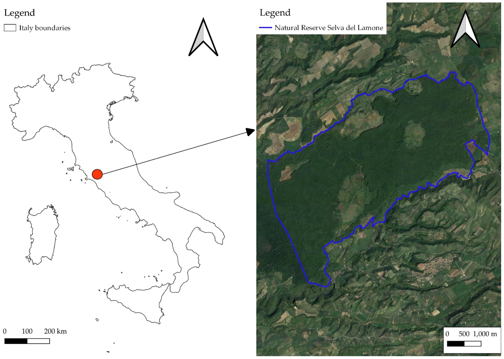
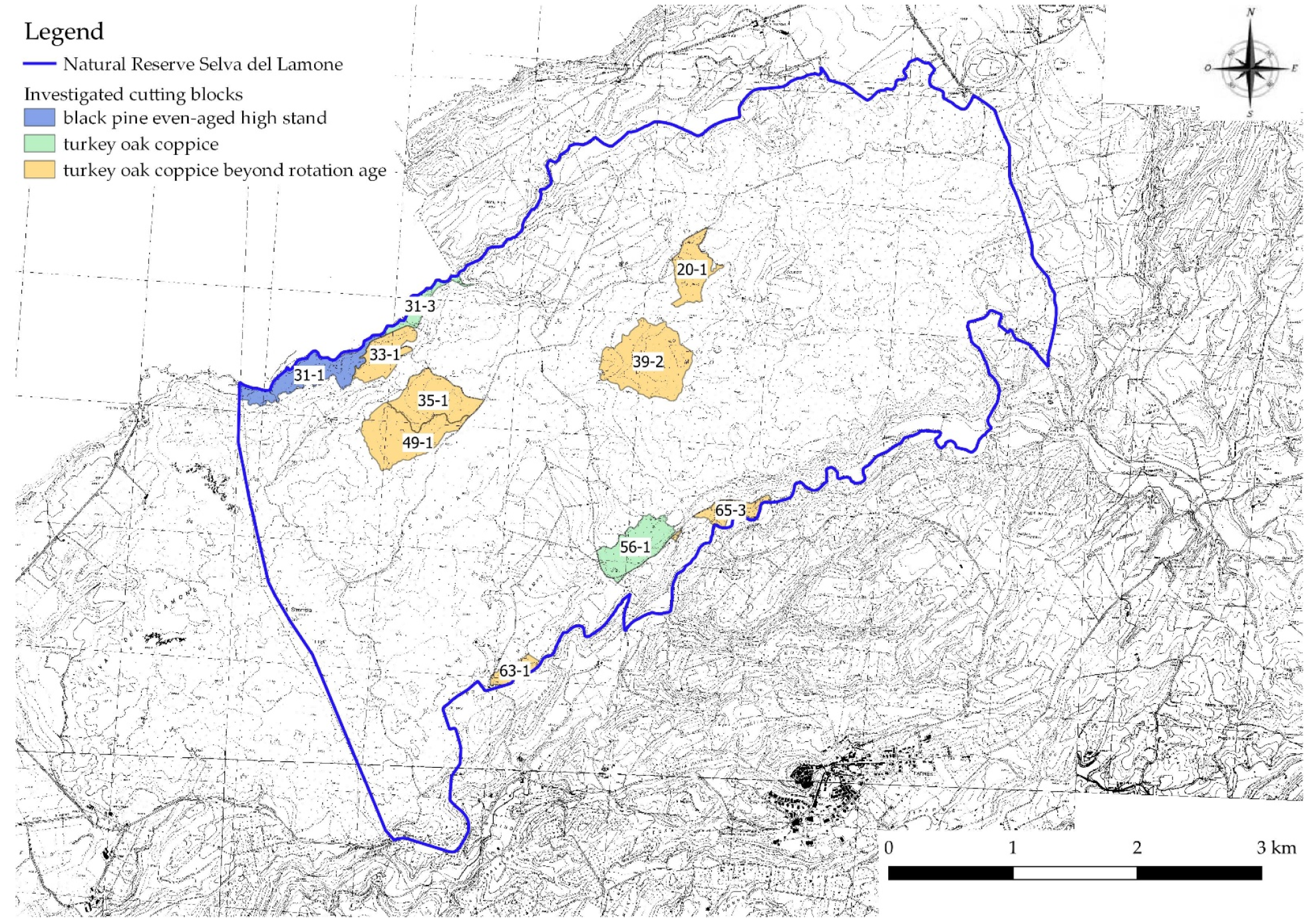
2.1. Study Area

The study focuses on the Natural Reserve Selva del Lamone, which is located in Central Italy, Latium Region, Farnese Municipality. The reserve covers an area of approximately 2000 ha. The average annual precipitation in the area is 1000 mm, with the highest precipitation in November and the lowest in July. Terrain morphology consists of a volcanic plateau with an alternation of fresh and fertile soils and zones with a high accumulation of rocks with lesser fertile soils. The main species of the area is turkey oak (Quercus cerris L.), but there are also several different tree species mixed with turkey oak, such as Acer campestre L., Quercus pubescens Willd., Acer monspessulanum L., Fraxinus ornus L., Quercus × crenata Lam., and Ulmus minor Mill.
Forest management is based on the coppice system; however, the abandonment of rural zones, which has occurred in the last decades, has led to the partial abandonment of forestry in several zones of the reserve. Therefore, a major part of the coppice cutting blocks is currently much beyond the conventional rotation age, which is about 20 years, with various degrees of transition to the high forest in the high fertility zones. Forest stands now have a structure that is very similar to those of even-aged high forests, while in the less fertile area, the polycormic structure of coppice is still evident, notwithstanding that the age is twice the conventional rotation age. The current forest management plan is valid for the 2016–2025 period and provides the maintenance of the coppice system in the cutting blocks with a lower age (<30 years), while in the other cutting blocks of higher age, thinning interventions that favor and accelerate the transition to the high forest is provided. In the zones with lower accessibility, the FMP provides no intervention at all, leaving such stands to the natural evolution. An aerial image of the study area is reported in Figure 1.

2.2. Methodological Framework

In the context of Italian forestry, with particular reference to Central and Southern Italy, forest engineers develop the FMP based on their own field surveys. Then, along the 10-year duration of the FMP, the forest engineer also carries out other field surveys for each cutting block to develop the EHP. In other words, FMP offers general guidelines for large surfaces of hundreds or thousands of hectares. It is required that an EHP is written for an area of 5–20 hectares shortly before harvesting. This provides more accurate information since forest engineering is required to perform local surveys.
A three-step procedure was implemented with the GIS software, Quantum GIS 3.16, to answer the question behind the experimental design. Firstly, the selection of the most suitable extraction system for each cutting block of the FMP was implemented with a GIS-AHP procedure, as described by Latterini et al. [29], by relying on a 10 m resolution Digital Elevation Model (available for free download for all national territory [30]) and the data retrieved from the FMP. The applied GIS-AHP procedure takes into consideration six variables that can influence the forest engineer in the selection of the extraction system. The only focus is on extraction operations exclusively carried out by chainsaw in the study area by forwarder, cable skidder, and all-terrain cable yarder. These variables are slopes of the area (%), road density (m ha−1), extraction distance (m), terrain roughness (%), soil-bearing capacity (kPa), and extracted timber amount (m3 ha−1). Maps related to the six variables for the study area are reported in the Supplementary Materials (Figures S1–S6). The values of each variable for the study area are retrieved and implemented into the GIS environment. At the same time, the AHP procedure is carried out to define the relative weights of each variable in the selection of each one of the considered tree extraction systems.
The procedure for implementing the GIS-AHP procedure to identify the most suitable extraction system can be summarized in the following steps: We obtain the data from six variables of interest for the study areas in raster format; We define the hierarchy of importance of the variables; We retrieve the relative weights for the variables by the AHP by interviewing experts on the topic through the development of pairwise comparison matrices; We apply a map algebra procedure consisting of a weighted average between the values of the six variables and their relative weights. This allows us to obtain a raster map that reports the suitability value for a given extraction system in each pixel. Therefore, in the present case, three suitability maps are obtained: one for the forwarder, one for the cable skidder, and one for the all-terrain cable yarder. Finally, the median value of suitability for each cutting block is extracted through a resampling procedure, and the extraction system with the highest median value of suitability in a given cutting block is considered the most suitable.
A detailed description of the methodology for the GIS-AHP procedure can be found in Latterini et al. [29]. The applied AHP weights are the ones obtained by Latterini et al. [29] after interviewing a wide pool of forest harvesting experts from all around the world (Table 1).
Secondly, ten cutting blocks were randomly selected (Figure 2), and in these cutting blocks, detailed surveys to retrieve data on the six above-mentioned variables were carried out.
The slope was measured by a clinometer (Haglöf, Långsele, Sweden) in a number of sample points ranging from 100 to 200 per cutting block, depending on the surface of the cutting block. Then, a Delaunay triangulation (TIN) algorithm was used to develop a 2 m resolution Digital Terrain Model (DTM). A detailed survey of the viability present in each cutting block was performed to evaluate road density by recording the track of each road with a handheld GNSS receiver, uploading the data into the GIS software, and converting them into a line shapefile. The methodology proposed by Picchio et al. to calculate topographic extraction distance, accounting for terrain slope [31], was implemented relying on the TIN DTM and the above-mentioned shapefile of road density. Soil-bearing capacity was measured in 20–30 sample points in each cutting block, depending on the dimension of the cutting block, with a light falling weight deflectometer TERRATEST® 4000 (Lehnitz/Berlin, Germany). Then, a TIN interpolation was carried out as well to obtain raster maps of soil-bearing capacity for each cutting block. Terrain roughness was assessed according to the methodology proposed in the Italian National Forest Inventory [32]. Ten transects measuring 2 m in width and 50 m in length, corresponding to 100 m2, were randomly selected within the surveyed cutting blocks. For each transect, obstacles (i.e., rocks, ditches, and fences) measuring more than 50 cm in absolute height were counted and measured for area assessment. Thus, terrain roughness in terms of percentage was calculated as the ratio between the total area of obstacles and the area of the transect. The threshold of 50 cm was selected because, considering alternatives for ground-based extraction machinery specifically developed for forestry (such as skidders and forwarders), rocks of lower height are not considered an obstacle for such machines. Finally, sample plots were established in each of the investigated cutting blocks to assess the standing volume and extracted timber amount. The sample plot surface was established to cover at least 10% of the overall cutting block surface. In each sample plot, the diameter at breast height (dbh–cm) was measured for all trees with a caliper, and the height of 50 trees belonging to different dbh classes was measured as well with a Vertex 5 hypsometer (Haglöf, Långsele, Sweden). Local allometric equations were used to estimate standing volume. For the estimation of the extracted timber amount, a simulation of the felling choice was carried out, annotating the diameter of the trees to be theoretically felled depending on the kind of treatment (coppicing or thinning) and estimating their volumes with the local allometric equations. An overall description of the different surveys carried out for the development of FMP and the second step of the present work are reported in Table 2.
Finally, the GIS-AHP procedure was repeated for the ten selected cutting blocks relying on the data collected during the field surveys to assess if, in these cutting blocks, the suggested extraction system was the same as the one suggested by the GIS-AHP procedure based on the retrieved data from the FMP.

2.3. Statistical Analyses

The statistical analysis concerned the evaluation of the differences between the suitability values for each extraction system in the investigated cutting blocks for the calculation starting from FMP data and from the detailed field surveys. The aim of the statistical analysis was to identify the variables where changing values were responsible for a variation in the suitability values.
The paired-sample Wilcoxon test was applied to investigate the differences between the suitability values calculated starting from the different input data, considering that the data did not meet the requirement of normality, making it impossible to apply a paired-sample t-test. Spearman’s rank correlation coefficient was calculated to investigate the correlation between a change in the suitability values for a given harvesting system and a change in the values of the variables moving from FMP data to data collected in the field.
All the statistical analyses were carried out using Statsoft Statistica software version 7.0 (Tulsa, OK, USA), considering a significance threshold of p < 0.05.

3. Results

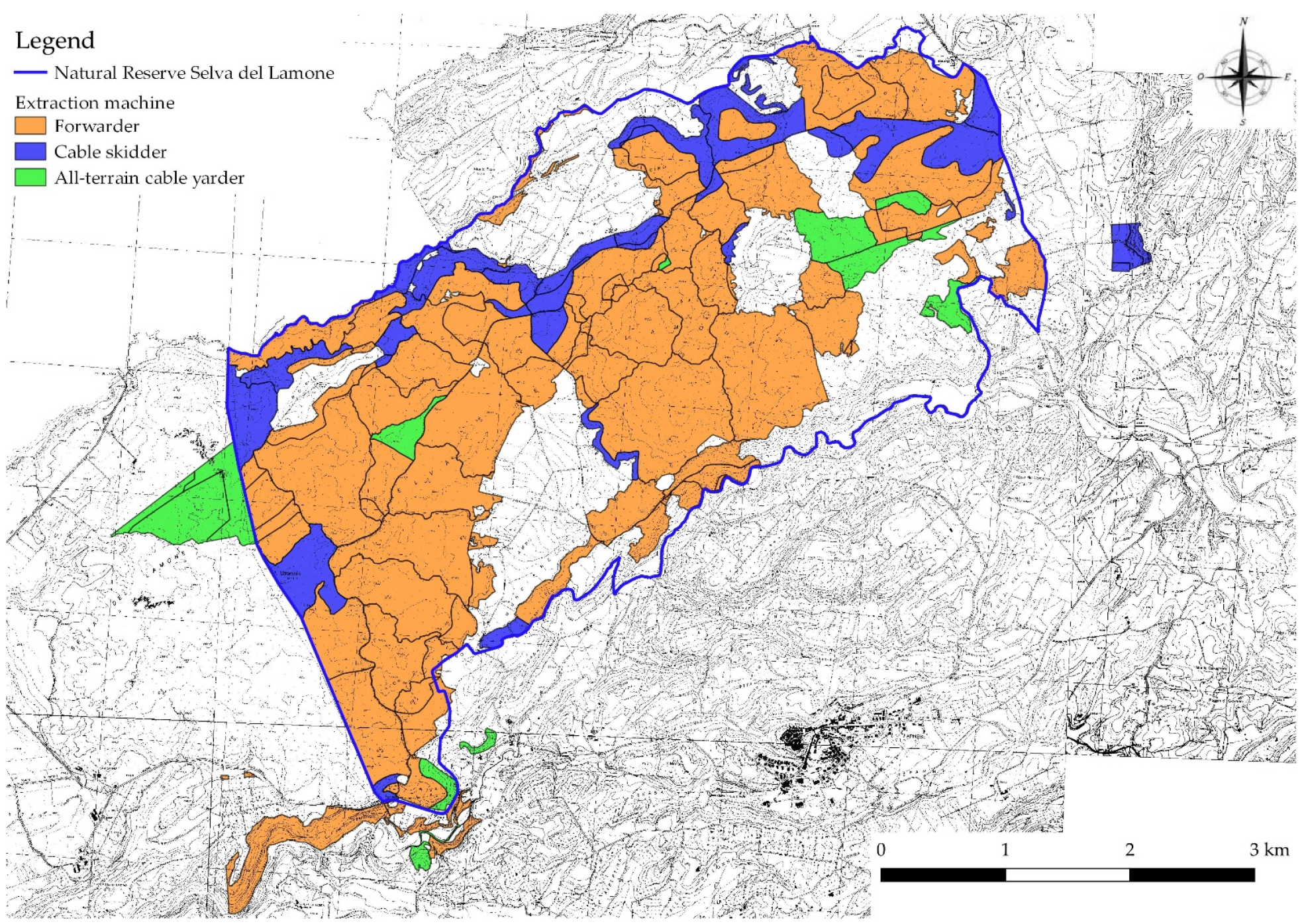
3.1. Identification of the Most Suitable Extraction System

The identification of the most suitable extraction system for all the cutting blocks of the study area is reported in Figure 3. Forwarders were the prevalent type of machine identified as the most suitable in a major part of the study area, that is to say, about 64% of the cutting blocks corresponding to 77% of the overall surface. Cable skidders were considered the most suitable alternative in about 24% of the cutting blocks, corresponding to 14.52% of the study area, particularly in those cutting blocks characterized by a low amount of extracted timber and located close to the existing road network. It is possible to notice that such cutting blocks are mostly located in the northern part of the study area. Finally, all-terrain cable yarders were suggested in only 12% of the cutting blocks, which is 8.75% of the study area surface, particularly in the cutting blocks with low soil-bearing capacity, a higher amount of extracted timber, and those in which the forest management plan provides intervention of coppicing with 80–90 standards per hectare.

3.2. Evaluation of the Results of the GIS-AHP Procedure

The values of the investigated variables calculated from the FMP surveys and from the field surveys carried out in the framework of the present study are given in Table 3. Values of the slope, extracted timber amount, roughness, and soil-bearing capacity changed when moving from FMP data to field surveys. Interestingly, data related to the road network density did not change. This is because the detailed field survey related to tracking road density did not report any other road than the ones already reported in the FMP forest road map. However, as a consequence of the calculation carried out with two different terrain models, the values of extraction distance also changed between FMP and field surveys. Indeed, the applied methodology for the calculation of extraction distance provides an orographic distance, which takes into account the slopes.
As a result of these changes in the variable values, three of the ten tested cutting blocks (31-1, 33-1, and 65-3) changed the suggested extraction system, in particular, shifting from forwarder to cable skidder (Table 4). In all of the three cutting blocks that changed, the suggested extraction system and scheduled intervention according to the forest management plan were thinning.
Statistical analyses were carried out to check the difference between the suitability values of the three extraction systems, while the data calculated from FMP and field surveys highlighted significant differences in the suitability values of forwarders (Wilcoxon test z = 2.0226 and p = 0.0431) and cable skidders (Wilcoxon test z = 2.3664 and p = 0.0179) but not for all-terrain cable yarders.
Spearman’s rank correlation analysis results are reported in Table 5. Considering that only forwarders and cable skidders showed statistically significant differences in suitability values calculated with FMP and field survey data, Spearman’s rank correlation analysis was only performed for these two extraction systems and not all-terrain cable yarders. Moreover, the variation in road density was null and not included in the analysis. The highest correlations were found for extracted timber amount both for forwarders (R = 0.67) and skidders (R = 0.45). For forwarders, the R-value for soil-bearing capacity (R = 0.63) is also rather high. However, no variable showed a significant correlation with the variations of suitability for both forwarders and skidders.

4. Discussion

4.1. Discussion of the Obtained Results

In Italy, forestry surface accounts for approximately one-third of the national territory [33]. Thus, managing such an extensive surface requires a combination of the expertise of forest engineers and the use of reliable tools. Precision forestry, with particular reference to GIS, has been proven to be an effective tool to help forest engineers in the framework of the implementation of sustainable forest operations [34]. However, without input data, which has a precision suitable for the target analysis, the precision forestry approach loses much of its effectiveness [35,36].
The aim of this study was to determine the level of accuracy of the base data that are available for Central and Southern Italy forest engineers who make the forest management plan. This study also sought to determine if the data was sufficient to develop a GIS-AHP procedure to produce a forest harvesting plan. This plan should provide information regarding the most suitable extraction system in each cutting block of the forest management plan before the actual implementation of the logging operations.
The obtained results showed that of the ten investigated cutting blocks, three changed the suggested extraction system after implementing more detailed field surveys in comparison with the ones that are typical for the development of a forest management plan. In detail, the three cutting blocks shifted the suggested extraction system from a forwarder to a cable skidder. It is evident that implementing a procedure that could potentially lead to a wrong decision 30% of the time is not suitable. However, the advantages of a preliminary harvesting plan that reduces time, labor, and management costs have been clearly highlighted by previous studies on the topic [17,37]. Therefore, the question arises of how to improve the input quality of a forest management plan’s data to a suitable level to develop a proper harvesting plan.
There are several possible solutions to this question, which should be implemented altogether, considering that our results from Spearman’s correlation analysis suggested that no particular variable caused a change that forced shifting in the harvesting system. Firstly, it should be worth the effort to cover all national territory with a 1 m resolution Digital Terrain Model (DTM) or at least with a Digital Elevation Model (DEM). Different European countries already have a 1 m DTM or DEM [35], while in Italy, only about 63% of the territory is covered by this kind of data [38]. This will allow an increased precision of slope maps. Although the results from Spearman’s correlation analysis did not reveal any variable had a significant influence on the changing of the suitability values for the investigated extraction systems, it is, however, possible to retrieve some important information about which variables we should focus our attention on to improve the affordability of the GIS-AHP procedure. In particular, R coefficient values higher than 0.6 were achieved for the forwarder by soil-bearing capacity and extracted timber amount, and the latter was also achieved for the cable skidder with an R-value of 0.45. Therefore, it could be worth the effort to improve the precision of data regarding these two variables during the development of a forest management plan. Direct measurement of soil-bearing capacity in the field through a portable falling weight deflectometer is excessively costly and time-consuming [39,40]. However, given that soil-bearing capacity is related to other physical characteristics, such as penetration resistance [41] (which is easily measurable through handheld penetrometers [42,43]), it could be possible to include this kind of evaluation during the field surveys for the development of a forest management plan.
Regarding increasing the precision of the estimation of the amount of extracted timber prior to harvesting implementation, we understand that it is not possible to ask the forest engineer who is developing the forest management plan to increase the forest surface covered by sample plots for biomass estimation. This is indeed a time-consuming process, and to carry out a precise biomass estimation on several thousand hectares of a forest management plan is simply impossible. However, remote and proximal sensing techniques to estimate forest biomass can be very helpful in this situation [44,45,46]. Although these techniques are not appropriate at the level of the Executive Harvesting Plan, which requires not only the biomass estimation but also the indication of trees to be felled or released by spray, they are suitable to carry out extensive biomass estimation on large surfaces, a factor which could be very helpful for the forest engineers in the phase of forest management plan development.

4.2. Study Limitations and Future Research

Notwithstanding the interesting results obtained in the study, it is worth mentioning to the readers about our study’s limitations. This study is indeed a preliminary trial performed at a case-study level. Furthermore, it only involves a single area in Central Italy. Every study dealing with the management of natural resources implies a plethora of factors, which could affect the final outcome, and therefore a single case study is not enough to shape general conclusions by itself. Future improvements should include larger areas and possible variable conditions so as to determine the limits better. It is worth mentioning, however, that the suggested approach here is fully repeatable in different study contexts, and it is able to provide answers to an important issue for forest engineers.

5. Conclusions

The implementation of AHP methods within the GIS environment has shown to be useful in selecting harvesting methods in the forestry sector, especially due to the objectiveness of the applied criteria. However, the main limiting factor is the accuracy of the input data used, such as the DTM or DEM resolution. The present case study aimed to investigate the reliability of the GIS-AHP in predicting the best harvesting method to apply to the forest in Central Italy by comparing the results with field data. The highest correlations were found between extracted timber amount and soil-bearing capacity with forwarders, while extraction distance exhibited the lowest correlation with both forwarders and skidders. Although the statistical analysis was not significant, it is noteworthy to highlight that, out of the ten cutting blocks tested, seven matched with the harvesting methods predicted by GIS-AHP. Therefore, it is reasonable to deduce that by increasing the resolution of input data, which are DTM and DEM, this tool would be made more powerful and reliable in predicting harvesting methods in the forestry sector.

Supplementary Materials

The following supporting information can be downloaded at: https://www.mdpi.com/article/10.3390/f14010127/s1, Figure S1: Slope map of the study area; Figure S2: Road density map; Figure S3: Extraction distance map; Figure S4: Map of extracted timber amount; Figure S5: Terrain roughness map; Figure S6: Map of soil-bearing capacity.

Author Contributions

Conceptualization, W.S., D.T., F.L. and R.P.; methodology, W.S., D.T. and F.L.; formal analysis, W.S., D.T. and F.L.; writing—original draft preparation, W.S. and D.T.; writing—review and editing, W.S., D.T., F.L., R.V., P.G., L.P. and R.P.; supervision, L.P. and R.P. All authors have read and agreed to the published version of the manuscript.

Funding

This study was carried out in cooperation with the Agritech National Research Center and received funding from the European Union’s Next-Generation EU package (PIANO NAZIONALE DI RIPRESA E RESILIENZA (PNRR)—MISSIONE 4 COMPONENTE 2, INVESTIMENTO 1.4—D.D. 1032 17/06/2022, CN00000022)—beneficiary of Tuscia University—DAFNE, scientific responsible: Prof. Rodolfo Picchio. The views and opinions in this manuscript are those of the authors. They do not purport to reflect the official policies of the European Union or the European Commission.

Data Availability Statement

Data is available upon request from the corresponding author.

Conflicts of Interest

The authors declare no conflict of interest.

References

  1. European Commission Circular Economy Action Plan. Available online: https://ec.europa.eu/environment/circular-economy/pdf/new_circular_economy_action_plan.pdf (accessed on 17 September 2022).
  2. European Commission Indirect Land Use Change (ILUC) What Are Biofuels? Available online: https://Ec.Europa.Eu/Commission/Presscorner/Detail/En/MEMO_12_787 (accessed on 20 September 2022).
  3. Lindegaard, K.N.; Adams, P.W.R.; Holley, M.; Lamley, A.; Henriksson, A.; Larsson, S.; von Engelbrechten, H.G.; Esteban Lopez, G.; Pisarek, M. Short Rotation Plantations Policy History in Europe: Lessons from the Past and Recommendations for the Future. Food Energy Secur. 2016, 5, 125–152. [Google Scholar] [CrossRef] [Green Version]
  4. Reinhardt, J.; Hilgert, P.; von Cossel, M. A Review of Industrial Crop Yield Performances on Unfavorable Soil Types. Agronomy 2021, 11, 2382. [Google Scholar] [CrossRef]
  5. FAO; UNEP. The Future of Our Land: Facing the Challenge- Guidelines for Intergrated Planning for Sustainable Mnanagement of Land Resources; Produced by the Land and Water Development Division of the Food and Agriculture Organization of the United Nations (FAO) in collaboration with the United Nations Environment Programme (UNEP); FAO: Rome, Italy; UNEP: Rome, Italy, 1999. [Google Scholar]
  6. Knight, R.L.; White, C. Conservation for a New Generation: Redefining Natural Resources Management; Island Press, Ed.; Island Press: Washington, DC, USA, 2008; ISBN 1597269212. [Google Scholar]
  7. Murphy, P.N.C.; Ogilvie, J.; Castonguay, M.; Zhang, C.F.; Meng, F.R.; Arp, P.A. Improving Forest Operations Planning through High-Resolution Flow-Channel and Wet-Areas Mapping. For. Chron. 2008, 84, 568–574. [Google Scholar] [CrossRef] [Green Version]
  8. Kangas, J.; Kangas, A. Multiple Criteria Decision Support in Forest Management—The Approach, Methods Applied, and Experiences Gained. For. Ecol. Manag. 2005, 207, 133–143. [Google Scholar] [CrossRef]
  9. Charis, G.; Danha, G.; Muzenda, E. A Review of the Application of GIS in Biomass and Solid Waste Supply Chain Optimization: Gaps and Opportunities for Developing Nations. In Proceedings of the International Conference on Industrial Engineering and Operations Management, Bandung, Indonesia, 6–8 March 2018; Volume 2018, pp. 42–52. [Google Scholar]
  10. Abreu, M.; Reis, A.; Moura, P.; Fernando, A.L.; Luís, A.; Quental, L.; Patinha, P.; Gírio, F. Evaluation of the Potential of Biomass to Energy in Portugal-Conclusions from the CONVERTE Project. Energies 2020, 13, 937. [Google Scholar] [CrossRef] [Green Version]
  11. López-Rodríguez, F.; Sanz-Calcedo, J.G.; Moral-García, F.J. Spatial Analysis of Residual Biomass and Location of Future Storage Centers in the Southwest of Europe. Energies 2019, 12, 1978. [Google Scholar] [CrossRef] [Green Version]
  12. Perpiñá, C.; Alfonso, D.; Pérez-Navarro, A.; Peñalvo, E.; Vargas, C.; Cárdenas, R. Methodology Based on Geographic Information Systems for Biomass Logistics and Transport Optimisation. Renew. Energy 2009, 34, 555–565. [Google Scholar] [CrossRef]
  13. Cristan, R.; Aust, W.M.; Bolding, M.C.; Barrett, S.M.; Munsell, J.F.; Schilling, E. Effectiveness of Forestry Best Management Practices in the United States: Literature Review. For. Ecol. Manag. 2016, 360, 133–151. [Google Scholar] [CrossRef] [Green Version]
  14. Picchio, R.; Latterini, F.; Mederski, P.S.; Tocci, D.; Venanzi, R.; Stefanoni, W.; Pari, L. Applications of GIS-Based Software to Improve the Sustainability of a Forwarding Operation in Central Italy. Sustainability 2020, 12, 5716. [Google Scholar] [CrossRef]
  15. Maleki, K.; Lafleur, B.; Leduc, A.; Bergeron, Y. Modelling the Influence of Different Harvesting Methods on Forest Dynamics in the Boreal Mixedwoods of Western Quebec, Canada. For. Ecol. Manag. 2021, 479, 118545. [Google Scholar] [CrossRef]
  16. Blagojević, B.; Jonsson, R.; Björheden, R.; Nordström, E.; Lindroos, O. Multi-Criteria Decision Analysis (MCDA) in Forest Operations—An Introductional Review. Croat. J. For. Eng. 2019, 40, 191–2015. [Google Scholar]
  17. Bont, L.G.; Fraefel, M.; Frutig, F.; Holm, S.; Ginzler, C.; Fischer, C. Improving Forest Management by Implementing Best Suitable Timber Harvesting Methods. J. Environ. Manag. 2022, 302, 114099. [Google Scholar] [CrossRef] [PubMed]
  18. Marchi, E.; Chung, W.; Visser, R.; Abbas, D.; Nordfjell, T.; Mederski, P.S.; McEwan, A.; Brink, M.; Laschi, A. Sustainable Forest Operations (SFO): A New Paradigm in a Changing World and Climate. Sci. Total Environ. 2018, 634, 1385–1397. [Google Scholar] [CrossRef] [PubMed] [Green Version]
  19. Marčeta, D.; Petković, V.; Ljubojević, D.; Potočnik, I. Harvesting System Suitability as Decision Support in Selection Cutting Forest Management in Northwest Bosnia and Herzegovina. Croat. J. For. Eng. 2020, 41, 251–265. [Google Scholar] [CrossRef]
  20. Gülci, N.; Akay, A.E.; Erdaş, O. Optimal Planning of Timber Extraction Methods Using Analytic Hierarchy Process. Eur. J. For. Res. 2020, 139, 647–654. [Google Scholar] [CrossRef]
  21. Pingoud, K.; Ekholm, T.; Sievänen, R.; Huuskonen, S.; Hynynen, J. Trade-Offs between Forest Carbon Stocks and Harvests in a Steady State—A Multi-Criteria Analysis. J. Environ. Manag. 2018, 210, 96–103. [Google Scholar] [CrossRef]
  22. Saaty, T.L. The Analytic Hierarchy Process; McGraw-Hill: New York, NY, USA, 1980. [Google Scholar]
  23. Ferreira da Silva, E.; Fernandes da Silva, G.; Orfanó Figueiredo, E.; Ribeiro de Mendonça, A.; Junio de Oliveira Santana, C.; César Fiedler, N.; Pereira Martins Silva, J.; Otone Aguiar, M.; Silva Santos, J. Optimized Forest Planning: Allocation of Log Storage Yards in the Amazonian Sustainable Forest Management Area. For. Ecol. Manag. 2020, 472, 118231. [Google Scholar] [CrossRef]
  24. Kazama, V.S.; Corte, A.P.D.; Robert, R.C.G.; Sanquetta, C.R.; Arce, J.E.; Oliveira-Nascimento, K.A.; DeArmond, D. Global Review on Forest Road Optimization Planning: Support for Sustainable Forest Management in Amazonia. For. Ecol. Manag. 2021, 492, 119159. [Google Scholar] [CrossRef]
  25. MacDicken, K.G.; Sola, P.; Hall, J.E.; Sabogal, C.; Tadoum, M.; de Wasseige, C. Global Progress toward Sustainable Forest Management. For. Ecol. Manag. 2015, 352, 47–56. [Google Scholar] [CrossRef] [Green Version]
  26. Sohrabi, H.; Jourgholami, M.; Jafari, M.; Shabanian, N.; Venanzi, R.; Tavankar, F.; Picchio, R. Soil Recovery Assessment after Timber Harvesting Based on the Sustainable Forest Operation (SFO) Perspective in Iranian Temperate Forests. Sustainability 2020, 12, 2874. [Google Scholar] [CrossRef] [Green Version]
  27. Ellis, E.A.; Montero, S.A.; Hernández Gómez, I.U.; Romero Montero, J.A.; Ellis, P.W.; Rodríguez-Ward, D.; Blanco Reyes, P.; Putz, F.E. Reduced-Impact Logging Practices Reduce Forest Disturbance and Carbon Emissions in Community Managed Forests on the Yucatán Peninsula, Mexico. For. Ecol. Manag. 2019, 437, 396–410. [Google Scholar] [CrossRef]
  28. Shukla, A.; Kumar, V.; Jain, K. Site Suitability Evaluation for Urban Development Using Remote Sensing, GIS and Analytic Hierarchy Process (AHP). In Proceedings of the International Conference on Computer Vision and Image Processing, Singapore, 27–29 December 2017; Raman, B., Kumar, S., Roy, P.P., Sen, D., Eds.; Springer: Singapore, 2017; pp. 377–388, ISBN 978-981-10-2107-7. [Google Scholar]
  29. Latterini, F.; Stefanoni, W.; Venanzi, R.; Tocci, D.; Picchio, R. GIS-AHP Approach in Forest Logging Planning to Apply Sustainable Forest Operations. Forests 2022, 13, 484. [Google Scholar] [CrossRef]
  30. Tarquini, S.; Vinci, S.; Favalli, M.; Doumaz, F.; Fornaciai, A.; Nannipieri, L. Release of a 10-m-Resolution DEM for the Italian Territory: Comparison with Global-Coverage DEMs and Anaglyph-Mode Exploration via the Web. Comput. Geosci. 2012, 38, 168–170. [Google Scholar] [CrossRef] [Green Version]
  31. Picchio, R.; Pignatti, G.; Marchi, E.; Latterini, F.; Benanchi, M.; Foderi, C.; Venanzi, R.; Verani, S. The Application of Two Approaches Using GIS Technology Implementation in Forest Road Network Planning in an Italian Mountain Setting. Forests 2018, 9, 277. [Google Scholar] [CrossRef] [Green Version]
  32. Inventario Nazionale Delle Foreste e Dei Serbatoi Forestali Di Carbonio. Istruzioni per Il Rilievo Degli Attributi Di Seconda Fase. Available online: https://www.inventarioforestale.org/it/ (accessed on 4 November 2022).
  33. INFC Inventario Nazionale Delle Foreste e Dei Serbatoi Forestali Di Carbonio. Available online: https://www.sian.it/inventarioforestale/jsp/01tabelle_superficie.jsp (accessed on 4 November 2022).
  34. Picchio, R.; Proto, A.R.; Civitarese, V.; di Marzio, N.; Latterini, F. Recent Contributions of Some Fields of the Electronics in Development of Forest Operations Technologies. Electronics 2019, 8, 1465. [Google Scholar] [CrossRef] [Green Version]
  35. Hoffmann, S.; Schönauer, M.; Heppelmann, J.; Asikainen, A.; Cacot, E.; Eberhard, B.; Hasenauer, H.; Ivanovs, J.; Jaeger, D.; Lazdins, A.; et al. Trafficability Prediction Using Depth-to-Water Maps: The Status of Application in Northern and Central European Forestry. Curr. For. Rep. 2022, 8, 55–71. [Google Scholar] [CrossRef]
  36. Mohtashami, S.; Eliasson, L.; Hansson, L.; Willén, E.; Thierfelder, T.; Nordfjell, T. Evaluating the Effect of DEM Resolution on Performance of Cartographic Depth-to-Water Maps, for Planning Logging Operations. Int. J. Appl. Earth Obs. Geoinform. 2022, 108, 102728. [Google Scholar] [CrossRef]
  37. Phelps, K.; Hiesl, P.; Hagan, D.; Hagan, A.H. The Harvest Operability Index (HOI): A Decision Support Tool for Mechanized Timber Harvesting in Mountainous Terrain. Forests 2021, 12, 1307. [Google Scholar] [CrossRef]
  38. D’Amico, G.; Vangi, E.; Francini, S.; Giannetti, F.; Nicolaci, A.; Travaglini, D.; Massai, L.; Giambastiani, Y.; Terranova, C.; Chirici, G. Are We Ready for a National Forest Information System? State of the Art of Forest Maps and Airborne Laser Scanning Data Availability in Italy. IForest 2021, 14, 144–154. [Google Scholar] [CrossRef]
  39. Klvač, R.; Vrána, P.; Jiroušek, R. Possibilities of Using the Portable Falling Weight Deflectometer to Measure the Bearing Capacity and Compaction of Forest Soils. J. For. Sci. 2010, 56, 130–136. [Google Scholar] [CrossRef] [Green Version]
  40. Kaakkurivaara, T.; Vuorimies, N.; Kolisoja, P.; Uusitalo, J. Applicability of Portable Tools in Assessing the Bearing Capacity of Forest Roads. Silva Fenn. 2015, 49, 1–26. [Google Scholar] [CrossRef]
  41. Benevenute, P.A.N.; de Morais, E.G.; Souza, A.A.; Vasques, I.C.F.; Cardoso, D.P.; Sales, F.R.; Severiano, E.C.; Homem, B.G.C.; Casagrande, D.R.; Silva, B.M. Penetration Resistance: An Effective Indicator for Monitoring Soil Compaction in Pastures. Ecol. Indic. 2020, 117, 106647. [Google Scholar] [CrossRef]
  42. Picchio, R.; Venanzi, R.; Tavankar, F.; Luchenti, I.; Iranparast Bodaghi, A.; Latterini, F.; Nikooy, M.; di Marzio, N.; Naghdi, R. Changes in Soil Parameters of Forests after Windstorms and Timber Extraction. Eur. J. For. Res. 2019, 138, 875–888. [Google Scholar] [CrossRef]
  43. Beckett, C.T.S.; Bewsher, S.; Guzzomi, A.L.; Lehane, B.M.; Fourie, A.B.; Riethmuller, G. Evaluation of the Dynamic Cone Penetrometer to Detect Compaction in Ripped Soils. Soil Tillage Res. 2018, 175, 150–157. [Google Scholar] [CrossRef] [Green Version]
  44. Halme, E.; Pellikka, P.; Mõttus, M. Utility of Hyperspectral Compared to Multispectral Remote Sensing Data in Estimating Forest Biomass and Structure Variables in Finnish Boreal Forest. Int. J. Appl. Earth Obs. Geoinform. 2019, 83, 101942. [Google Scholar] [CrossRef]
  45. Wallis, C.I.B.; Homeier, J.; Peña, J.; Brandl, R.; Farwig, N.; Bendix, J. Modeling Tropical Montane Forest Biomass, Productivity and Canopy Traits with Multispectral Remote Sensing Data. Remote Sens. Environ. 2019, 225, 77–92. [Google Scholar] [CrossRef]
  46. Zhu, Y.; Feng, Z.; Lu, J.; Liu, J. Estimation of Forest Biomass in Beijing (China) Using Multisource Remote Sensing and Forest Inventory Data. Forests 2020, 11, 163. [Google Scholar] [CrossRef]
Figure 1. Aerial image of the study area and location within Italy.
Forests 14 00127 g001
Figure 2. Details of the investigated cutting blocks.
Forests 14 00127 g002
Figure 3. Extraction system suggested by the GIS-AHP procedure in all the cutting blocks of the study area. It is important to notice that there are some cutting blocks outside the boundaries of the Natural Reserve Selva del Lamone. However, these cutting blocks, even if outside the reserve’s territory, are managed by the Natural Reserve concerning forest management issues.
Forests 14 00127 g003
Table 1. AHP pairwise comparison matrix and weights [29]. S: slope; ED: extraction distance; SBC: soil-bearing capacity; ETA: extracted timber amount; RD: road density; RG: terrain roughness; CR: consistency ratio (must be < 0.1 for the AHP weights to be considered reliable).
Forwarder
CriteriaSEDSBCETARDRGWeightsCR
S110.51110.1430.0001
ED-10.51110.143
SBC--12220.286
ETA---1110.143
RD----110.143
RG-----10.143
Cable Skidder
CriteriaSEDSBCETARDRGWeightsCR
S10.5120.510.1360.002
ED-123120.259
SBC--120.510.136
ETA---10.33330.50.075
RD----120.259
RG-----10.136
All-terrain Cable Yarder
CriteriaSEDSBCETARDRGWeightsCR
S1130.3333130.1610.01
ED-130.3333130.161
SBC--10.20.333310.06
ETA---1350.399
RD----130.161
RG-----10.06
Table 2. Description of the surveys carried out by the local forest engineer for the development of the FMP and by the authors of the present work.
VariableFMPThis Work
Slope (%)A 10 m DEM available for free downloadSampling points in the cutting blocks and TIN interpolation to develop a 2 m DTM
Road density (m ha−1)Shapefile was developed by relying on available topographic maps and on the basis of the previous EHPsField surveys and recording of the tracks by GNSS receiver
Extraction distance (m)Calculation accounting on the shapefile of roadsCalculation of topographic distance relying on the shapefile of roads and the 2 m DTM
Terrain roughness (%)Visual assessmentDirect measurement by transects
Soil-bearing capacity (kPa)Visual assessmentAssessment by deflectometer and TIN interpolation
Extracted timber amount (m3 ha−1)Sample plots (generally 800–1000 m2 per cutting block) for estimating standing volume and fixed percentage of removal to estimate extracted timber amount (85% for coppicing and 30–40% for thinning)Sample plots (covering at least 10% of the cutting block surface) and detailed assessment of the trees to be removed, estimating their volumes separately
Table 3. Values of the six variables used for the GIS-AHP procedures were calculated from FMP data and from the field surveys carried out in the present study.
FMP
Cutting blockInterventionSlope (%)Extracted timber amount (m3 ha−1)Road density (m ha−1)Extraction distance (m)Roughness (%)Soil-bearing capacity (kPa)
20-1Thinning6.716082.38121.922060
31-1Thinning11.515075.4948.632060
31-3Coppicing13.26150156.6841.572060
33-1Thinning13.215875.3890.893580
35-1Thinning6.145054.19122.334580
39-2Thinning6.44550.00544.313570
49-1Thinning5.38507.63274.204580
56-1Coppicing8.8112563.38108.682060
63-1Thinning6.0435158.5037.032060
65-3Thinning23.8535131.5456.093580
Field surveys
Cutting blockInterventionSlope (%)Extracted timber amount (m3 ha−1)Road density (m ha−1)Extraction distance (m)Roughness (%)Soil-bearing capacity (kPa)
20-1Thinning10.9150.3482.38118.232969
31-1Thinning5.1177.0075.4946.87170
31-3Coppicing6.99100.30156.6839.54170
33-1Thinning15.4890.9075.3888.21189
35-1Thinning3.3127.9954.19109.361890
39-2Thinning5.3160.760.00487.252379.5
49-1Thinning9.8141.407.63256.211890.5
56-1Coppicing5.81101.3563.38104.292770
63-1Thinning11.1242.60158.5036.012170
65-3Thinning12.1438.40131.5451.261290
Table 4. Suggested extraction system for the investigated parcels with the output of the GIS-AHP procedure developed by the FMP data and field surveys carried out in the framework of this study. The italic bold indicates the cutting blocks with a different suggested extraction system between the two simulations.
Cutting BlockField SurveysFMP
20-1ForwarderForwarder
31-1Cable skidderForwarder
31-3Cable skidderCable skidder
33-1Cable skidderForwarder
35-1ForwarderForwarder
39-2ForwarderForwarder
49-1ForwarderForwarder
56-1ForwarderForwarder
63-1Cable skidderCable skidder
65-3Cable skidderForwarder
Table 5. Spearman’s R and p-value for the various couple comparison between variations of suitability values for forwarder and cable skidder and variations of the six variables’ values. For variation, what is meant is the difference between the values calculated from FMP data and the values retrieved after the field surveys carried out in the present study. FORW: forwarder; SKID: skidder; S: slope; ED: extraction distance; SBC: soil-bearing capacity; ETA: extracted timber amount; RG: terrain roughness.
Spearman’s Rp-Value
FORW and S0.2236>0.05
FORW and RG−0.2294>0.05
FORW and SBC0.6309>0.05
FORW and ETA0.6708>0.05
FORW and ED−0.1118>0.05
SKID and S0.21622>0.05
SKID and RG−0.3028>0.05
SKID and SBC0.2644>0.05
SKID and ED−0.1261>0.05
SKID and ETA0.4505>0.05
Disclaimer/Publisher’s Note: The statements, opinions and data contained in all publications are solely those of the individual author(s) and contributor(s) and not of MDPI and/or the editor(s). MDPI and/or the editor(s) disclaim responsibility for any injury to people or property resulting from any ideas, methods, instructions or products referred to in the content.

