Article

Forest Landscape Model Initialization with Remotely Sensed-Based Open-Source Databases in the Absence of Inventory Data

Matrosov Institute for System Dynamics and Control Theory, Siberian Branch of Russian Academy of Sciences, Irkutsk 664033, Russia
*
Author to whom correspondence should be addressed.
Forests 2023, 14(10), 1995; https://doi.org/10.3390/f14101995
Submission received: 7 September 2023 / Revised: 27 September 2023 / Accepted: 29 September 2023 / Published: 4 October 2023
(This article belongs to the Section Forest Inventory, Modeling and Remote Sensing)

Abstract

:
Forecasts of the forest ecosystem dynamics are important for environmental protection and forest resource management. Such forecasts can support decisions about where and how to restore damaged forests and plan felling, and in forest conservation. Forest landscape models (FLM) are used to predict changes in forests at the landscape level. FLM initialization usually requires detailed tree species and age data; so, in the absence of forest inventory data, it is extremely difficult to collect initial data for FLM. In our study, we propose a method for combining data from open sources, including remote sensing data, to solve the problem of the lack of initial data and describe initializing the LANDIS-II model. We collected land cover classification and above-ground biomass products, climate, soil, and elevation data to create initial vegetation and ecoregion maps. Our method is based on some simplifications of the study object—some tree species are replaced by groups of species; the forest stand is considered homogeneous. After initialization, the natural dynamics without harvesting and disturbances were simulated by the Biomass Succession extension for 200 years. The study presents a detailed methodology that can be used to initialize other study areas and other FLMs with a lack of field data.

1. Introduction

Forecasting the state of forest ecosystems is necessary to manage forest resources and determine strategies for their use [1,2]. Models allow us to construct different scenarios for forest management, simulate planned impacts, obtain forecasts for development, and provide estimates of the long-term environmental and economic consequences of all forest management options [3,4]. The resulting estimates prevent undesirable changes in ecosystems, such as loss of forest area, loss of biodiversity, and degradation of soil quality.
For areas the size of a district and a region, forest landscape models are used. They cover a spatial scale of 100–10,000 km2 in a time range from several decades to hundreds of years. By type, landscape models are divided into two main categories—phenomenological and process. The phenomenological ones are based on empirical data and experimental material that estimates the transition probabilities for forest inventory and management planning [5,6]. The disadvantage of this group is the dependence of the result on the stability of the initial conditions, while there is no possibility to consider possible changes in climate and modeling territory.
Process models describe the ecosystem structure and the mechanisms underlying its functioning. They consider the interaction of the main factors (for example, soil, climate, light) and processes (species competition, growth, anthropogenic impact, photosynthetic respiration, community succession), which makes it possible to simulate the forest landscapes dynamics in time and space [7,8,9]. Process models produce the details of the main components and processes of ecosystems, making it possible to assess their ecological development for the coming decades and to predict the impact of various types of disturbances, the implementation of management decisions, and climate change on the forest [10]. Accounting for a variety of factors leads to the evaluation of a large number of scenarios, which ultimately gives the most reliable forecasts of the forest state.
For most forest landscape models, the initial input data are vegetation maps containing information about certain characteristics of trees growing in the study area (species, age, biomass, etc.). One of the most widely used FLM models is the LANDIS-II (Landscape Disturbance and Succession Model) [11,12,13,14,15], which was developed to simulate changes in forest ecosystems based on disturbance and succession processes. The model takes into account various types of disturbances, such as fires, wind, and diseases, as well as succession processes such as tree growth and competition between them. The initial dataset for LANDIS-II depends on the succession extension used—in the simplest version, this is information about tree species and age classes (Age-Only Succession extension), maximum above-ground biomass and net productivity, climate data (Biomass Succession extension), respiration and photosynthesis parameters (PnET Succession), soils, nitrogen, and carbon parameters (NECN succession).
The LandClim model [16,17] simulates forest landscapes over a time from decades to millennia. The base entity in LandClim—a cohort of trees—is always associated with a separate grid cell. The initial data are the species and age of the trees, climate data, and geographical characteristics, e.g., height, slope, and aspect. The iLand model considers the effects of climate change, competition between trees and other plants, and the impact of anthropogenic activities. The basic entity is individual trees; at their level, the processes of growth, mortality, and competition are modeled. In the TreeMig model [18], geographical and climate parameters, the number of trees, and their height classes for different species are specified for the grid cells. It is believed that trees are randomly distributed within the cell, as well as their density and light.
Thus, the most commonly used FLMs require information about tree species and age classes. Collecting such information of acceptable accuracy over large areas is a complex task, often requiring a combination of data from different sources [19]. With the increase in the study area size, it becomes more difficult to collect field data, and sometimes inaccessible due to the geographical characteristics and low transport accessibility of the territory. At the same time, the existing data of the National Forest Inventory are not always available to researchers in full format.
The study shows FLM initialization with the LANDIS-II model. LANDIS-II simulates forest landscapes larger than 100 ha. It includes a wide library of extensions for simulating various ecosystem processes at the plantation and landscape level (succession, fires, wind, felling, tree diseases), as well as the main module that controls the interaction between extensions [11,12,20,21]. In LANDIS-II, the study area is divided into a grid of interacting sites; in each site, trees of a certain species and age class grow. Each age class of one species in the model represents a cohort. Various processes (succession, anthropogenic impacts) take place between the sites. At the same time, each cohort competes for resources (light, soil moisture, space) among different species in the same cell. Within sites, stand-level forest processes occur, while landscape-level processes, such as tree seed dispersal and disturbance, typically affect several neighboring sites. Moreover, the landscape can be divided into several ecoregions, each of which combines cells with similar ecological conditions that affect the forest state. To take into account such influence, parameters of ecoregions for individual species—for example, the ability to acclimatize in a given region—are added to extensions.
Information about tree species can be obtained from land cover classification products from satellite images. At present, several land cover classifications have been developed, the set of classes of which includes different species or groups of tree species (coniferous, broad-leaved, etc.) [22,23,24]. It is also possible to obtain information about the tree age from remote sensing data. The age of a certain species is directly related to its biomass, this correspondence can be found in regional reference materials (yield tables). One source of the amount of biomass data is maps of above-ground biomass (AGB). AGB is the living vegetation above the ground, including stem, stump, twigs, bark, seeds, and foliage, expressed as mass per unit area.
When quantifying biomass, forest properties are often characterized by three types of remote sensing data [25,26]: passive optical spectral reflections are sensitive to vegetation structure (leaf area index, crown size, and tree density), texture, and shade; radar data measures the dielectric and geometric properties of forests; lidar data characterize the vertical structure and height of vegetation. Different types of data have their own advantages and disadvantages in depicting forest properties, so methods of combining data from several sensors are often used to achieve a higher accuracy of biomass estimation. Empirical regression models, non-parametric methods, and physically based allometric models are used to determine the correspondence between remote sensing data and forest biomass indicators. Moreover, FLM usually requires data on climate and soils with sufficient expansion to initialize the parameters of the regions of the study area. Such data can be obtained from open databases [27,28].
Therefore, one source for FLM initialization are open remotely sensed-based databases. The advantage of using them is to increase the speed and reduce the cost of preparing the input data for the models. The development of satellite instruments makes it possible to obtain regular information about the state of various ecosystems anywhere in the world, including vegetation. The purpose of this paper is to describe the available data sources for FLM initialization, compare their capabilities, and present a step-by-step process for collecting and integrating information to map the initial state of the forest landscape. Achieving this goal will facilitate the use of FLM to assess the state of the forest in the future, even in areas where inventory data are not available to researchers.

2. Materials and Methods

2.1. Study Area

To simulate forest landscape changes, the Goloustnenskye forestry area of the Irkutsk region was chosen as a study area. It covers approximately 223 thousand hectares, including lands covered with forest—213 thousand hectares, which is over 95% of the total area of the forestry district. The Goloustnenskye forestry area belongs to the South Siberian mountain forest zone and the Baikal mountain forest region [29]. The main tree species include conifers: pine (Pinus sylvestris) covers 109,000 ha, larch (Larix sibirica) 26,000 ha, spruce (Picea abies) 4000 ha, fir (Abies sibirica) 650 ha, and cedar (Pinus sibirica) 17,000 ha; and deciduous forest: birch (Betula pendula) 32,000 ha and aspen (Populus tremula) 13,000 ha [30]. Biodiversity includes swampy areas of the forest, stony places, steep slopes, water bodies, and karst formations (Figure 1). The complex nature of the landscape and the large size of the forests prevent its detailed ground survey.

2.2. Initial Data

A list of data used in this study is given in Table 1.

2.2.1. Sites and Ecoregions

The smallest area unit in LANDIS-II is a site, homogeneous in terms of its parameters (light level, soil, etc.). Different tree species of different ages may be present on a site at one point in time. Sites can be combined due to the limitations of initial data and computer resources required to perform model calculations. If the site is outside the area of interest or covered by non-forest land, it is marked as inactive. To create a site map, a vector map of the quarters of the Goloustnenskye forestry area was chosen from the forest inventory materials.
In LANDIS-II, the study area is divided into different land types or ecoregions. An ecoregion is one or more cells united by similar ecological conditions (climate, soil, etc.) that influence succession and disturbance processes. The selection of such objects makes it possible to use their parameters to rank the influence of environmental conditions on the forest in different parts of the study area. For example, the model can set the probability of establishment or death of a species in each ecoregion.
Soil data can be obtained from regional soil maps; in this study, The Unified State Register of Soil Resources of Russia (http://egrpr.soil.msu.ru) was used. It contains a soil map of Russia at a 1:2,500,000 scale with data on the main soil complex of the polygon, associated soils, and parent rocks.

2.2.2. Climate

The climate data for the FLM typically include monthly averages of minimum and maximum air temperature and precipitation. Weather stations in the territory are not always present in sufficient numbers. For example, there is only one weather station in the NCEI (National Centers for Environmental Information (https://www.ncei.noaa.gov)) global database for our study area.
At the same time, there are spatial climate databases that can become the basis for determining the parameters of forest models. We used the WorldClim (https://www.worldclim.org) database, which collects historical climate data with a spatial resolution of 30 s (approximately 1 km2) to 10 min (approximately 340 km2). WorldClim provides two types of data: average data for the 1970–2000 period and monthly data from 1960 to 2018. Both types are presented as a set of GeoTiff (.tif) files and include average minimum and maximum air temperatures in degrees Celsius and total precipitation in mm. In the first version of the averaged data, the average temperature, solar radiation (kJ/m2 per day), wind speed (m/s), and water vapor pressure (kPa) parameters are also available. Moreover, data on 19 bioclimatic variables reflecting annual trends (annual mean temperature, annual temperature range, annual precipitation, seasonality, etc.) are available for download.
Additionally, evapotranspiration values for the study area zones are needed for Biomass Succession extension. They can be obtained from the Terra/MODIS MOD16A3GF Version 6.1 Evapotranspiration/Latent Heat Flux satellite product (https://lpdaac.usgs.gov/products/mod16a3gfv061/, accessed on 19 August 2023), which contains 500 m resolution cumulative evapotranspiration data for a year, with global coverage from 2000 to the present. The product is based on meteorological reanalysis data, MODIS data on albedo, and land cover property dynamics.

2.2.3. Tree Species

To generate input data for FLM, it is necessary to determine the species and age of trees in the study area, divided into sections with a given step. Modern products of the land cover classification with a 30 m resolution allow you to create maps of species composition sufficient for FLM. The FROM-GLC (Finer Resolution Observation and Monitoring—Global Land Cover (http://data.starcloud.pcl.ac.cn/, accessed on 30 August 2023) product contains global land cover classification data for the year 2017 with a 10 m resolution and for 2015 with a 30 m resolution. Although the data for 2017 have a better resolution, there are only general “forest” and “shrub” classes in the class set. In addition, in 2015, the forest class is divided into subclasses, namely, broadleaf, needleleaf, and mixed leaf, each of which includes additional categories, i.e., with leaves and without leaves (leaf-on, leaf-off).
Product GLC_FCS30-2020 (Global Land Cover with Fine Classification System at 30m in 2020 (https://zenodo.org/record/4280923#.Y-WyTC_P0Q8, accessed on 30 August 2023) [31] is an updated version of GLC_FCS30-2015. Landsat time series, Sentinel-1 radar data, and DEM elevation data were used to create this classification. Tree species classes include evergreen broadleaved, deciduous broadleaved, evergreen needle-leaved, deciduous needle-leaved, and mixed, each of which includes a category of closed and open trees. There are also classes of shrub, which can be deciduous and coniferous.
Of course, these classifications do not provide information about specific species but only about their groups. If there are land cover materials based on a local training sample available, they should be used. However, in the absence of such materials, the global products described above become the right choice in the initial data collection step for FLM. After all, even the separation of coniferous and deciduous species provides enough information for forestry, especially if there are few forest-forming species (there are only seven of them in the study area).

2.2.4. Trees Age

There are several global AGB datasets. Global Forest Watch (https://data.globalforestwatch.org/, accessed on 24 August 2023) contains a 30 m resolution map of measurements in the year 2000. Above-ground biomass was calculated using 700,000 LiDAR measurement points, regional allometric equations, and Landsat images. GlobBiomass (https://globbiomass.org/) [32] is a project of the European Space Agency (ESA) with data for 2010. The AGB map was built by combining the satellite radar observations (SAR) of ALOS PALSAR and Envisat ASAR. The SAR observations served as predictors in the search model; metrics based on 2003–2009 lidar observations and Landsat-7 reflection for 2010 were used to estimate the parameters. Validation of the resulting map with a database of 110,897 ground-based AGB measurements showed a high agreement with the results.
ESA Biomass Climate Change Initiative (https://climate.esa.int/en/projects/biomass/, accessed on 25 August 2023) is a development of the GlobBiomass project. It contains AGB estimates for 2010, 2017, and 2018 at 100 m resolution derived from a combination of Sentinel-1 radar data, Envisat ASAR, and ALOS PALSAR. LiDAR ICESat and GEDI data were taken to calibrate the model—they reflect the structural features of vegetation, but their samples are still too rough to be used for a full assessment of forest variables. Optical data were not used due to their insignificant contribution. Additionally, raster databases took part in the algorithm’s process calibrating and sampling remote sensing data: MODIS, Landsat, AVHRR, CCI vegetation cover density maps, DEM heights, WorldClim climate variables, and allometric equations for linking LiDAR and AGB data.
To link the AGB datasets with the species age parameters, regional normative materials on the biological productivity of vegetation are used. Such materials provide information on phytomass volume by tree fractions, net primary production, and net ecosystem production by species and age in different forest zones. In this case, phytomass refers to the amount of organic matter of living plants in a forest ecosystem. The AGB corresponds to the parameter of the amount of above-ground forest stand phytomass, t·ha−1. Information on the correspondence of biomass to species and ages for the study area was taken from [33].

2.3. Model Initialization

Vector and raster data processing was carried out with QGIS 3.30 software (Open Source Geospatial Foundation, Beaverton, OR, USA), and the Python 3.7 script was created to compare age classes by biomass. The kernel and extensions for LANDIS-II are obtained from the official website of the model: https://www.landis-ii.org.

2.3.1. Making Ecoregions Map

To compile an ecoregions map, soil polygons in the Goloustnenskye forestry area were identified from the soil map of Russia. The following attributes participated in the analysis: the name of the main soil, associated soil (if any), and parent rocks (two or one). Additionally, climate data were loaded from WorldClim: precipitation, minimum and maximum temperatures as averages for 1970–2000 monthly values with 30 s spatial resolution. From the same source, an elevation map was obtained from the SRTM data. In the QGIS batch processing mode, all climate and elevation files were cropped along the boundaries of the study area; then, the average values of all variables were calculated for each soil polygon using the “Cell statistics” QGIS function. After comparing the values of all polygons, the final map was compiled from six ecoregions. An ecoregion can be marked as inactive to exclude some regions (e.g., river areas, fields) from the simulation. The LANDIS-II input is a rectangular raster map, so the area outside the study area in the bounding box was marked as an inactive ecoregion.

2.3.2. Making Initial Species Map

The data collection process for model initialization began with the selection of a land cover classification product. Tree species were compared from both the FROM-GLC-2015 and GLC_FCS30-2020 databases. The land cover products were reduced to one set of classes, their areas were calculated, and the values for forest classes were compared with the total areas from the forest inventory for 2018 from the “Forest Plan of the Irkutsk Region for 2019–2028” [34] (Table A1 in Appendix A). Additionally, the values of the overall accuracy and producer and user accuracy were calculated for both products in QGIS using the AcATAMa plugin. To assess the accuracy, 200 points were generated and randomly distributed over the study area. Each point was assigned a land cover class using high-resolution satellite images from Google Maps. Further, these classes were sequentially compared with the classes at the same points for FROM-GLC-2015 and GLC_FCS30-2020, an error matrix was built, and accuracy parameters were calculated.
Tree species of the study area were combined into groups—coniferous (pine, spruce, fir, cedar), larch, and deciduous (birch, aspen). To obtain a map of the initial state, the volume of biomass was taken from the AGB ESA Biomass Climate Change Initiative for 2018 as a TIF file. The choice of ESA Biomass was made because that this dataset is the most recent of those reviewed (2018), and the inventory data from the “Forest Plan” of the total areas by species and age classes for comparison were available for 2018 (Table A1 in the Appendix A).
The layers of the GLC_FCS30-2020 land cover, AGB ESA Biomass, and site map were merged in QGIS. The resulting map was processed VIA a Python script, and information about available species and age classes was collected for each site.
In LANDIS-II, it is required that we specify not a specific age of trees, but an age class consisting of a certain range of years, the size of which depends on the tree species. To compare the age classes with the AGB in [33], the data for pine were taken for the class coniferous forest class and birch for the deciduous forest because these species occupy the largest area (70%) in their group according to the inventory data. The obtained values were compared with forest management data for the Goloustnenskye forestry area concerning the area of species of different age classes for 2018, taken from [33] (Table A2, Table A3 and Table A4). The “Growth Tables” [33] present data for different regions and bonitet. In this study, values were chosen for the region closest to the study area—Eastern Siberia, Baikal region, and Irkutsk region. Bonitet is an indicator of the productivity of forest stands, depending on the average age and height of a stand, and is divided into classes from Ia to Va. As a basis, we consider the stand to be homogeneous and take the data of bonitet II for all species after comparing the calculated values with forest management data from [34].
For comparison, the calculated areas of trees of each species group were summarized by age classes, and data were taken from [34] (Table A1) for the distribution of the area of tree species by five age classes for 2018. This allowed us to adjust the correspondence between the tables of biomass and age by species to obtain an acceptable correlation with the general inventory data (Table A5). For adjustment, at each iteration of the calculations, correspondences between AGB and age class were established and the sums of areas by age classes were calculated and compared with inventory data; then, the correspondences were adjusted until a satisfactory result was obtained. Of course, the relationship between AGB and tree age depends on various factors (e.g., stand productivity, growing density). To simplify the calculations, we relied on the relations of the obtained data with inventory data of a rougher scale.

2.4. Model Simulation

The duration of the simulation period was set at 200 years. This duration is due to the specificity of the study area; there are many coniferous trees with an average life cycle of 200 years. Therefore, over the selected period, we can trace the cycle of natural dying and subsequent regeneration of the forest in the study area. The Biomass Succession extension was used to study the succession. Biomass Succession simulates the biomass of each cohort as a function of age, competition, and disturbances. The input data comprise a map of the initial state of forest sites, a map of ecoregions, and a table of species parameters. Additional data on biomass and climate are required. Biomass data include the maximum net primary production (ANPP) and total biomass (AGB) for each species in each ecoregion. The climate data for the model include monthly averages of minimum and maximum air temperature and precipitation.
Biomass Succession does not include possible human impacts on the forest and disturbances, considering instead only natural succession. The extension additionally requires biomass and climate data as initial data (Table 2). The ANPP and AGB parameters were calculated according to [33] for each species group. ANPPmax is the maximum possible above-ground net primary productivity for each species; BiomassMax is the maximum AGB for the species in g m−2 (Table A2, Table A3 and Table A4).
The establish and mortality probabilities were determined via a semi-empirical method. We first estimated the existing distribution of tree species across the territory and soil types; for example, in ecoregion 4, larches grow better on carbonate soils, so its “Establish probability” is equal to 1.0, while in regions 2 and 3, according to the classification, there are fewer larches, so we set “Establish probability” to 0.8. The final calibration of the values was carried out after several iterations of the model run when the resulting output biomass maps were compared with the initial state and information on the life span of the different species.
Moreover, average evapotranspiration values were calculated based on the MOD16A3GF product for 2018 for each ecoregion, and a file was prepared for the climate library with the values of precipitation and minimum and maximum temperatures by months according to WorldClim data.

3. Results

3.1. Ecoregion Map

After selecting the Goloustnenskye forestry area from the soil map, we obtained Figure 2. In Table 3, all soil, elevation, and climatic parameters for selected polygons are listed.
The soil parameters for polygons 2 and 5 (Figure 2) are the same, but they differ significantly in the amount of precipitation (384.49 and 421.79 mm) and elevation (870.11 and 848.83 m), so they cannot be combined. It was shown in [35] that the accuracy of the separation of ecoregions has a rather strong effect on the predictions of species distribution on the landscape scale. Figure 3 shows that the central polygons 1 and 6 noticeably differ with respect to the values of climatic parameters. Polygon 3 is close to polygons 2 and 5 in terms of soil characteristics but differs from them in all climatic parameters. As a result, it was decided to combine only polygons 3 and 7 for the convenience of calculations—polygon 7 has the smallest area, and the values of its climatic variables are close to the values of polygon 3. The resulting map of ecoregions contains six active polygons.

3.2. Initial Species Map

Figure 4 presents a comparison of FROM-GLC-2015 and GLC_FCS30-2020 classification products. A total of 200 stratified sample points were placed randomly to assess the accuracy of these classifications in the study area.
As a result, the GLC_FCS30-2020 showed higher overall accuracy and higher producer and user accuracy, including values for forest classes (Table 4). The FROM-GLC-2015, values of the area of coniferous forests turned out to be closer to the inventory data; for deciduous forests, if we consider their area together with mixed forests (in the forest plan, area values for specific species are given), both products attained values close to the inventory ones. At the same time, it is visually noticeable that in FROM-GLC-2015, an excessive part of the territory was incorrectly labeled with the “Bareland” class. Moreover, the advantage of GLC_FCS30-2020 was the presence of the deciduous needle-leaved forest class, which made it possible to distinguish the larch species in addition to the classes of coniferous and deciduous forests. Larch, despite belonging to coniferous trees, differs from them in terms of the relationship between biomass and tree age, and trees of this species occupy over 26,000 hectares in the study area. Separating this species into a separate class will improve the accuracy of the simulation. Therefore, the product GLC_FCS30-2020 was chosen for further work.
On the territory of the Goloustnenskye forestry area, 615 sites were identified from the map of the quarterly network. After its spatial intersection with the map of ecoregions, their number increased to 835. The resulting polygons with an area of fewer than five hectares were merged with neighboring ones, after which 791 sites remained on the resulting map.
As a result of combining the GLC_FCS30-2020, AGB, and sites layers, the map of the tree species and age initial state for LANDIS-II was formed (Figure 5). Darker shades in each group of species correspond to older trees.

3.3. Model Simulation Results

The graph of the biomass dynamics by species classes (Figure 6) and maps of the dynamics of the total biomass (Figure 7) were built after simulation with the Biomass Succession extension for the Goloustnenskye forestry area for 200 years from 2018. The graph shows how the total amount of above-ground biomass gradually decreases in the first 80 years; then, over the next 80 years, there is an increase in biomass, followed by a decline again. The dynamics of larch biomass roughly follow the trend of the total volume, with a sharper decrease in the first 80 years. The biomass of evergreens grows continuously during the first 160 years, which is associated with the longer life span of conifers. In deciduous biomass, a decline occurs in the first 40 years, followed by an increase of 80 years, followed by a decline again.
Biomass maps (Figure 7) show spatial dynamics. The image shows that at the beginning of the simulation, large amounts of biomass are concentrated in the northern and eastern parts of forestry. After 40 years, AGB is concentrated in the northwestern part; and after 80 years, it noticeably decreases. After 120 years, we see an increase in biomass in the southeastern part and after 160 years in the northwestern part; and after 200 years, a decrease in biomass is observed in the southeastern part. This spatial distribution of biomass over time is determined by the initial state of the study area (Figure 5)—there are more conifers in the southeastern part, which have a longer lifespan and higher biomass compared to the deciduous forest.

4. Discussion

Our results demonstrate that the data needed to initialize FLM can be collected from open sources. Many studies [14,36,37,38,39] use the available forest inventory data (for example, national or regional cadasters), which contain detailed information about forest types, tree age, diameter, height, and disturbances. In the absence of such data, FLM initialization becomes a difficult task.
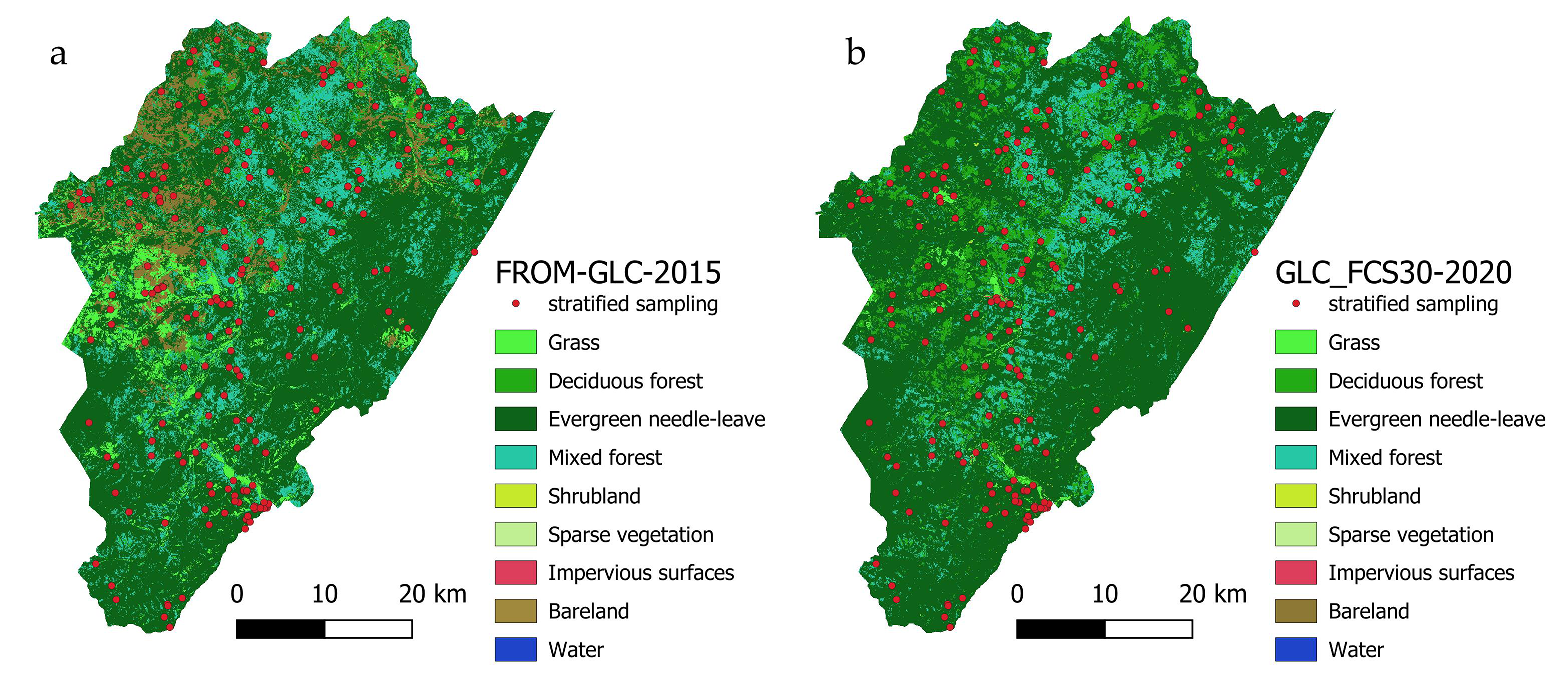
The emergence in recent years of global land cover classifications with a resolution of 10–30 m and classes of different tree species allows us to come closer to solving this problem. Using such classifications as the basis for combining the initial map for FLM is based on simplification—instead of specific tree species, their groups are taken (coniferous, deciduous, etc.). If the region of interest does not contain many forest-forming species and each group has a dominant species, the application of the proposed approach will be justified. Moreover, groups of species can be used to initialize models when it is necessary to trace the general trends in forest dynamics in the territory.
With the development of machine learning methods and the improvement of remote sensing data quality, it became possible to classify areas occupied by specific tree species on satellite images [40,41,42,43,44]. Here, it is possible to separate different species with 95%–97% accuracy in high and ultra-high resolution images, which makes it possible to build detailed maps of forest species composition based on classification materials. If a training sample is available, this approach makes it possible to conduct an automated forest inventory. The authors of the study are also working in this direction, based on the use of a unique regional set of classes and neural networks [45].
Of course, the use of remote sensing data to create initial FLM maps needs further verification. Unlike field data, satellite images are subject to factors that can significantly distort them. Clouds, shadows, aerosols, and light levels perturb the data, which cannot always be smoothed out by correction. Using alternative data leads to a simplification of the study object, which should affect the accuracy of the result. For example, we linked the biomass and age of the trees of the “coniferous forest” group with data on the productivity of a pine stand of a certain density. In reality, over large areas, a forest is rarely homogeneous.
Using the land classifications and AGB maps is limited by the release date—such materials take a long time to produce, so finding up-to-date data for the current or previous year can be a difficult or even impossible task. When preparing initial data from various sources, it is necessary to pay attention to the year of their production—forest parameters change regularly because of natural growth, felling, and disturbance, so a difference in data collection of one year can sufficiently increase the error. In our study, most of the products used correspond to 2018.
The advantages of the proposed approach are lower cost and higher speed of data preparation for model initialization compared to a ground survey of forests. As the size of the survey area increases from the local level to the level of regional landscapes, the amount of work to collect in situ data increases significantly, so processing information from open databases allows us to increase the efficiency of modeling.
The process of data collection and processing described in the paper made it possible to successfully create the initial map of the species, age classes, and ecoregions, and to calibrate the parameters of the LANDIS-II model. At the same time, only values of areas by tree species and age classes for the whole forestry were available from the inventory data, which were used to calibrate the model parameters. The selected satellite data made it possible to divide the study area into 791 sites and to describe the species–age composition in each of them.
The simulation results for the Goloustnenskye forestry area showed that LANDIS-II provides interesting predictive data. Information about the spatial dynamics of the biomass of various tree species helps us to understand the future state of the territory, and to predict changes in the structure and functioning of forests in response to climatic, anthropogenic, and other factors.

5. Conclusions

This paper presents a methodology for collecting data from open sources for the initialization of forest landscape models. Our study describes different satellite data, the combination of which made it possible to create an initial map of the species–age composition and set the initial parameters of the LANDIS-II model in the absence of detailed forest inventory data.
This approach is associated with some simplifications—we replaced part of the tree species with groups of species, and we consider the forest stand to be homogeneous in its characteristics throughout the study area. Simplifications usually reduce the accuracy of the simulation results, but in the absence of inventory data, our approach allows us to collect initial data for FLM and observe forest dynamics, albeit of a reduced quality. The main datasets used are global, so our methodology can be used for other regions of interest. In the future, we plan to add information about felling, fires, and other impacts to the model; perform simulation on LANDIS-II extensions that allow for the forecasting of carbon stocks in the forest; and consider different climate scenarios.

Author Contributions

Conceptualization, I.B. and A.P.; methodology, A.P.; writing—original draft preparation, I.B. and A.P.; writing—review and editing, A.P.; visualization, A.P.; supervision, I.B. All authors have read and agreed to the published version of the manuscript.

Funding

This research was funded by grant No. 075-15-2020-787 of the Ministry of Science and Higher Education of the Russian Federation for the implementation of a large scientific project in priority areas of scientific and technological development (the project “Fundamentals, methods and technologies for digital monitoring and forecasting of the ecological situation of the Baikal natural territory”).

Data Availability Statement

The land cover data was downloaded from Global Land Cover with Fine Classification System (https://zenodo.org/record/4280923#.Y-WyTC_P0Q8, accessed on 30 August 2023). The above-ground biomass data was obtained from ESA Biomass Climate Change Initiative (https://climate.esa.int/en/projects/biomass/, accessed on 25 August 2023) The climate data was derived from WorldClim dataset (https://www.worldclim.org, accessed on 3 September 2023). The evapotranspiration data was downloaded from MODIS Version 6.1 (https://lpdaac.usgs.gov/products/mod16a3gfv061/, accessed on 19 August 2023). The elevation data was obtained from SRTM (https://www.worldclim.org, accessed on 15 August 2023). The soil data was derived from Unified state register of soil resources of Russia dataset (http://egrpr.soil.msu.ru, accessed on 5 September 2023).

Conflicts of Interest

The authors declare no conflict of interest.

Appendix A

Table A1. Inventory data from the “Forest Plan of the Irkutsk Region” of the total areas by species and age classes.
Total Areas by Species, haAge Classes, ha
Young 1 ClassYoung 2 ClassIntermediate-AgeRipeningMature and OvermatureIncl. Overmature
Pine108,999484617,38638,39411,28337,09019,728
Spruce397302632800329581158
Fir656012414112326895
Larch26,4691844526059218017,59410,439
Cedar16,78923293715958455460710
Total conifers156,886735921,94056,97814,46956,14030,430
Birch32,08181115511,093353192911828
Aspen12,88165792999737049062047
Total deciduous44,96214,6908412,090390114,1973875
Shrubs58655014724135190180
Total207,71322,09923,49673,20318,56070,35534,305
Table A2. Dynamics of biological productivity of modal birch stands in the mountain taiga ecoregions of the Baikal region (bonitet II).
AgeBiomass, Mg/haNet Primary Production
TrunkBark WoodLeafTotal Above-Ground
105.81.70.98.4270
2025.75.72.333.7458
3050.79.93.163.7534
4073.413.43.690.4548
5091.116.23.8111.1535
60103.818.23.8125.8512
70112.419.83.7135.9490
80118213.6142.6472
90121.4223.5146.9458
100123.422.93.4149.7448
Table A3. Dynamics of biological productivity of full pine stands in Central and Eastern Siberia (bonitet II).
AgeBiomass, Mg/haNet Primary Production
TrunkBark WoodNeedlesTotal Above-Ground
20294.34.237.5273
408210.36.498.7474
60131.314.97.1153.3536
80169.917.97.1194.9536
100197.819.76.8224.3510
120217.420.76.3244.4476
14023121.25.8258445
160240.421.35.4267.1417
180246.921.35273.2395
Table A4. Dynamics of biological productivity of full larch stands in forest steppe ecoregions of Buryatia and Irkutsk region (bonitet II).
AgeBiomass, Mg/haNet Primary Production
TrunkBark WoodNeedlesTotal Above-Ground
109.44.61.415.4268
2028.47.52.338.2394
4076.611.43.391.3514
60125.414.03.9143.3552
80168.615.84.3188.7554
100204.417.34.6226.3542
120232.918.44.8256.1526
140255.019.44.9279.3512
160271.720.35297.0500
Table A5. Comparison of areas by tree species and age classes according to inventory data and our calculations.
Tree SpeciesData SourceArea by Age Class, haCorrelation Coefficient
Young 1 ClassYoung 2 ClassIntermediate-AgeRipeningMatureOvermatureTotal
ConifersThis study2310.9721,362.1644,947.832,540.49791.49978.61102,931.50.668
Inventory717521,48850,91912,28918,55519,991130,417
LarchThis study3775.521,146.9829,5182655.42325.1495.8457,516.88−0.214
Inventory18445260592180715510,43926,469
DeciduousThis study2310.882497.8113,068.7410,939.5811,003.293784.2743,604.570.260
Inventory14,6908412,090390110,322387544,962

References

  1. Porté, A.; Bartelink, H.H. Modelling Mixed Forest Growth: A Review of Models for Forest Management. Ecol. Modell. 2002, 150, 141–188. [Google Scholar] [CrossRef]
  2. Acevedo, M.F.; Urban, D.L.; Shugart, H.H. Models of Forest Dynamics Based on Roles of Tree Species. Ecol. Modell. 1996, 87, 267–284. [Google Scholar] [CrossRef]
  3. Vladimirov, I.N.; Chudnenko, A.K. Multilevel Modeling of the Forest Resource Dynamics. Math. Model. Nat. Phenom. 2009, 4, 72–88. [Google Scholar] [CrossRef]
  4. Burkhart, H.E.; Tomé, M. Modeling Forest Trees and Stands; Springer: Dordrecht, The Netherlands, 2012; ISBN 9788578110796. [Google Scholar]
  5. Furniss, T.J.; Hessburg, P.F.; Povak, N.A.; Salter, R.B.; Wigmosta, M.S. Predicting Future Patterns, Processes, and Their Interactions: Benchmark Calibration and Validation Procedures for Forest Landscape Models. Ecol. Modell. 2022, 473, 110099. [Google Scholar] [CrossRef]
  6. Löw, M.; Koukal, T. Phenology Modelling and Forest Disturbance Mapping with Sentinel-2 Time Series in Austria. Remote Sens. 2020, 12, 4191. [Google Scholar] [CrossRef]
  7. Fabrika, M.; Valent, P.; Merganičová, K. Forest Modelling and Visualisation—State of the Art and Perspectives. Cent. Eur. For. J. 2019, 66, 147–165. [Google Scholar] [CrossRef]
  8. McKenzie, P.F.; Duveneck, M.J.; Morreale, L.L.; Thompson, J.R. Local and Global Parameter Sensitivity within an Ecophysiologically Based Forest Landscape Model. Environ. Model. Softw. 2019, 117, 1–13. [Google Scholar] [CrossRef]
  9. Lindenmayer, D.B.; Likens, G.E. The Science and Application of Ecological Monitoring. Biol. Conserv. 2010, 143, 1317–1328. [Google Scholar] [CrossRef]
  10. Gustafson, E.J. When Relationships Estimated in the Past Cannot Be Used to Predict the Future: Using Mechanistic Models to Predict Landscape Ecological Dynamics in a Changing World. Landsc. Ecol. 2013, 28, 1429–1437. [Google Scholar] [CrossRef]
  11. Scheller, R.M.; Domingo, J.B.; Sturtevant, B.R.; Williams, J.S.; Rudy, A.; Gustafson, E.J.; Mladenoff, D.J. Design, Development, and Application of LANDIS-II, a Spatial Landscape Simulation Model with Flexible Temporal and Spatial Resolution. Ecol. Modell. 2007, 201, 409–419. [Google Scholar] [CrossRef]
  12. Sturtevant, B.R.; Yang, J.; Gustafson, E.J. LANDIS: A Spatially Explicit Model of Forest Landscape Disturbance, Management, and Succession LANDIS 4.0 Users Guide; Gen. Tech. Rep. NC-263; U.S. Department of Agriculture, Forest Service, North Central Research Station: St. Paul, MN, USA, 2005; 93p. [Google Scholar]
  13. Scheller, R.M.; Mladenoff, D.J. A Forest Growth and Biomass Module for a Landscape Simulation Model, LANDIS: Design, Validation, and Application. Ecol. Modell. 2004, 180, 211–229. [Google Scholar] [CrossRef]
  14. Maxwell, C.J.; Scheller, R.M.; Wilson, K.N.; Manley, P.N. Assessing the Effectiveness of Landscape-Scale Forest Adaptation Actions to Improve Resilience under Projected Climate Change. Front. For. Glob. Chang. 2022, 5, 740869. [Google Scholar] [CrossRef]
  15. Simons-Legaard, E.; Legaard, K.; Weiskittel, A. Predicting Aboveground Biomass with LANDIS-II: A Global and Temporal Analysis of Parameter Sensitivity. Ecol. Modell. 2015, 313, 325–332. [Google Scholar] [CrossRef]
  16. Bouriaud, L.; Bouriaud, O.; Elkin, C.; Temperli, C.; Reyer, C.; Duduman, G.; Barnoaiea, I.; Nichiforel, L.; Zimmermann, N.; Bugmann, H. Age-Class Disequilibrium as an Opportunity for Adaptive Forest Management in the Carpathian Mountains, Romania. Reg. Environ. Chang. 2015, 15, 1557–1568. [Google Scholar] [CrossRef]
  17. Thrippleton, T.; Dolos, K.; Perry, G.L.W.; Groeneveld, J.; Reineking, B. Simulating Long-Term Vegetation Dynamics Using a Forest Landscape Model: The Post-Taupo Succession on Mt Hauhungatahi, North Island, New Zealand. N. Z. J. Ecol. 2014, 38, 26–38. [Google Scholar]
  18. Lischke, H.; Zimmermann, N.E.; Bolliger, J.; Rickebusch, S.; Löffler, T.J. TreeMig: A Forest-Landscape Model for Simulating Spatio-Temporal Patterns from Stand to Landscape Scale. Ecol. Modell. 2006, 199, 409–420. [Google Scholar] [CrossRef]
  19. Suárez-Muñoz, M.; Mina, M.; Salazar, P.C.; Navarro-Cerrillo, R.M.; Quero, J.L.; Bonet-García, F.J. A Step-by-Step Guide to Initialize and Calibrate Landscape Models: A Case Study in the Mediterranean Mountains. Front. Ecol. Evol. 2021, 9, 653393. [Google Scholar] [CrossRef]
  20. Sturtevant, B.R.; Gustafson, E.J.; Li, W.; He, H.S. Modeling Biological Disturbances in LANDIS: A Module Description and Demonstration Using Spruce Budworm. Ecol. Modell. 2004, 180, 153–174. [Google Scholar] [CrossRef]
  21. Marcon, A.; Mladenoff, D.J.; Grignolio, S.; Apollonio, M. Effects of Forest Management and Roe Deer Impact on a Mountain Forest Development in the Italian Apennines: A Modelling Approach Using LANDIS-II. PLoS ONE 2019, 14, e0224788. [Google Scholar] [CrossRef]
  22. Anand, A.; Pandey, M.K.; Srivastava, P.K.; Gupta, A.; Khan, M.L. Integrating Multi-Sensors Data for Species Distribution Mapping Using Deep Learning and Envelope Models. Remote Sens. 2021, 13, 3284. [Google Scholar] [CrossRef]
  23. Soleimannejad, L.; Ullah, S.; Abedi, R.; Dees, M.; Koch, B. Evaluating the Potential of Sentinel-2, Landsat-8, and Irs Satellite Images in Tree Species Classification of Hyrcanian Forest of Iran Using Random Forest. J. Sustain. For. 2019, 38, 615–628. [Google Scholar] [CrossRef]
  24. Persson, M.; Lindberg, E.; Reese, H. Tree Species Classification with Multi-Temporal Sentinel-2 Data. Remote Sens. 2018, 10, 1794. [Google Scholar] [CrossRef]
  25. Durante, P.; Martín-Alcón, S.; Gil-Tena, A.; Algeet, N.; Tomé, J.L.; Recuero, L.; Palacios-Orueta, A.; Oyonarte, C. Improving Aboveground Forest Biomass Maps: From High-Resolution to National Scale. Remote Sens. 2019, 11, 795. [Google Scholar] [CrossRef]
  26. Li, Y.; Li, M.; Li, C.; Liu, Z. Forest Aboveground Biomass Estimation Using Landsat 8 and Sentinel-1A Data with Machine Learning Algorithms. Sci. Rep. 2020, 10, 9952. [Google Scholar] [CrossRef] [PubMed]
  27. Fick, S.E.; Hijmans, R.J. WorldClim 2: New 1-km Spatial Resolution Climate Surfaces for Global Land Areas. Int. J. Climatol. 2017, 37, 4302–4315. [Google Scholar] [CrossRef]
  28. Mu, Q.; Zhao, M.; Running, S.W. Improvements to a MODIS Global Terrestrial Evapotranspiration Algorithm. Remote Sens. Environ. 2011, 115, 1781–1800. [Google Scholar] [CrossRef]
  29. Popova, A.K.; Cherkasin, E.A.; Vladimirov, I.N. Forest Resources of the Baikal Region: Vegetation Dynamics Under Anthropogenic Use. Springer Proc. Earth Environ. Sci. 2019, 1, 96–106. [Google Scholar] [CrossRef]
  30. Appendix 8 to the order of the Ministry of the Forestry Complex of the Irkutsk Region dated 28 January 2022 No. 91-7-mpr. In Forest Regulations Goloustnensky Forestry of the Irkutsk Region; Branch of FSBI “Roslesinforg” “Vostsiblesproekt”: Krasnoyarsk, Russia, 2022; p. 424.
  31. Zhang, X.; Liu, L.; Chen, X.; Gao, Y.; Xie, S.; Mi, J. GLC_FCS30: Global Land-Cover Product with Fine Classification System at 30 m Using Time-Series Landsat Imagery. Earth Syst. Sci. Data 2021, 13, 2753–2776. [Google Scholar] [CrossRef]
  32. Santoro, M.; Cartus, O.; Carvalhais, N.; Rozendaal, D.M.A.; Avitabile, V.; Araza, A.; De Bruin, S.; Herold, M.; Quegan, S.; Rodríguez-Veiga, P.; et al. The Global Forest Above-Ground Biomass Pool for 2010 Estimated from High-Resolution Satellite Observations. Earth Syst. Sci. Data 2021, 13, 3927–3950. [Google Scholar] [CrossRef]
  33. Shvidenko, A.; Schepaschenko, D.; Nilsson, S. Tables and Models of Growth and Productivity of Forests of Major Forest Forming Species of Northern Eurasia (Standard and Reference Materials); Federal Agency of Forest Management, International Institute for Applied Systems Analysis: Moscow, Russia, 2008; p. 886. [Google Scholar]
  34. Appendix to the Decree of the Governor of the Irkutsk Region dated 29 May 2019 No. 112-ug. In Forest Plan of the Irkutsk Region 2019–2028; Government of the Irkutsk Region: Irkutsk, Russia, 2019; p. 217.
  35. Liang, Y.; He, H.S.; Fraser, J.S.; Wu, Z.W. Thematic and Spatial Resolutions Affect Model-Based Predictions of Tree Species Distribution. PLoS ONE 2013, 8, e67889. [Google Scholar] [CrossRef]
  36. Tremblay, J.A.; Boulanger, Y.; Cyr, D.; Taylor, A.R.; Price, D.T.; St-Laurent, M.H. Harvesting Interacts with Climate Change to Affect Future Habitat Quality of a Focal Species in Eastern Canada’s Boreal Forest. PLoS ONE 2018, 13, e0191645. [Google Scholar] [CrossRef] [PubMed]
  37. Molina, E.; Valeria, O.; Martin, M.; Montoro Girona, M.; Ramirez, J.A. Long-Term Impacts of Forest Management Practices under Climate Change on Structure, Composition, and Fragmentation of the Canadian Boreal Landscape. Forests 2022, 13, 1292. [Google Scholar] [CrossRef]
  38. Hall, R.J.; Skakun, R.S.; Arsenault, E.J.; Case, B.S. Modeling Forest Stand Structure Attributes Using Landsat ETM+ Data: Application to Mapping of Aboveground Biomass and Stand Volume. For. Ecol. Manag. 2006, 225, 378–390. [Google Scholar] [CrossRef]
  39. Petter, G.; Mairota, P.; Albrich, K.; Bebi, P.; Brůna, J.; Bugmann, H.; Haffenden, A.; Scheller, R.M.; Schmatz, D.R.; Seidl, R.; et al. How Robust Are Future Projections of Forest Landscape Dynamics? Insights from a Systematic Comparison of Four Forest Landscape Models. Environ. Model. Softw. 2020, 134, 104844. [Google Scholar] [CrossRef]
  40. Axelsson, A.; Lindberg, E.; Reese, H.; Olsson, H. Tree Species Classification Using Sentinel-2 Imagery and Bayesian Inference. Int. J. Appl. Earth Obs. Geoinf. 2021, 100, 102318. [Google Scholar] [CrossRef]
  41. Grabska, E.; Frantz, D.; Ostapowicz, K. Evaluation of Machine Learning Algorithms for Forest Stand Species Mapping Using Sentinel-2 Imagery and Environmental Data in the Polish Carpathians. Remote Sens. Environ. 2020, 251, 112103. [Google Scholar] [CrossRef]
  42. Jombo, S.; Adam, E.; Odindi, J. Classification of Tree Species in a Heterogeneous Urban Environment Using Object-Based Ensemble Analysis and World View-2 Satellite Imagery. Appl. Geomatics 2021, 13, 373–387. [Google Scholar] [CrossRef]
  43. Grabska, E.; Hostert, P.; Pflugmacher, D.; Ostapowicz, K. Forest Stand Species Mapping Using the Sentinel-2 Time Series. Remote Sens. 2019, 11, 1197. [Google Scholar] [CrossRef]
  44. Zhang, T.; Su, J.; Xu, Z.; Luo, Y.; Li, J. Sentinel-2 Satellite Imagery for Urban Land Cover Classification by Optimized Random Forest Classifier. Appl. Sci. 2021, 11, 543. [Google Scholar] [CrossRef]
  45. Bychkov, I.V.; Ruzhnikov, G.M.; Fedorov, R.K.; Popova, A.K.; Avramenko, Y.V. On Classification of Sentinel-2 Satellite Images by a Neural Network ResNet-50. Comput. Opt. 2023, 47, 474–481. [Google Scholar] [CrossRef]
Figure 1. Study area: (a) location of the Goloustnenskye forestry area; (b) map of the Goloustnenskye forestry area.
Forests 14 01995 g001
Figure 2. Soil polygons.
Forests 14 01995 g002
Figure 3. Thematic data: (a) minimum temperature; (b) maximum temperature; (c) precipitation; (d) elevation.
Forests 14 01995 g003
Figure 4. Land Cover classifications: (a) FROM-GLC-2015; (b) GLC_FCS30-2020 on the same set of classes.
Forests 14 01995 g004
Figure 5. The resulting map of the tree species and age composition.
Forests 14 01995 g005
Figure 6. Graph of biomass dynamics by species.
Forests 14 01995 g006
Figure 7. The total output AGB maps by years: (a) initial time; (b) after 40 years; (c) after 80 years; (d) after 120 years; (e) after 160 years; (f) after 200 years from the beginning of the simulation.
Forests 14 01995 g007
Table 1. Used data sources.
Data TypeNameDescriptionYearSpatial ResolutionParameters
Species classificationGLC_FCS30-2020Global Land Cover with Fine Classification System (https://zenodo.org/record/4280923#.Y-WyTC_P0Q8, accessed on 30 August 2023)202030 mLand cover classification classes
BiomassESA Biomass Climate Change InitiativeAbove-ground biomass (https://climate.esa.int/en/projects/biomass/, accessed on 25 August 2023) 2018100 mAbove-ground biomass (Mg/ha)
Biophysical conditionsWorldClimHistorical monthly average climate data in raster format (https://www.worldclim.org, accessed on 3 September 2023) 1970–200030 sMinimum temperature (°C), maximum temperature (°C), precipitation (mm)
MOD16A3GFMODIS Version 6.1 Evapotranspiration (https://lpdaac.usgs.gov/products/mod16a3gfv061/, accessed on 19 August 2023) 2018500 mTotal evapotranspiration (kg/m²/year)
ElevationElevation data from SRTM (https://www.worldclim.org, accessed on 15 August 2023)200030 sElevation (m.a.s.l.)
Plots and regionsQuarterly networkVector map of quarters from forest inventory materials -Grid for the Goloustnenskye forestry area
The Unified State Register of Soil Resources of RussiaSoil map of Russia 1:2,500,000 scale (http://egrpr.soil.msu.ru, accessed on 5 September 2023) -The name of the main soil, associated soil, and parent rocks
Table 2. Biomass parameters.
EcoregionClassEstablish ProbabilityMortality ProbabilityANPPmax, g m−2BiomassMax, g m−2
1Deciduous1054815,000
Coniferous1055127,300
Larch0.9055429,700
2Deciduous1054815,000
Coniferous1055127,300
Larch0.8055429,700
3Deciduous1054815,000
Coniferous1055127,300
Larch0.8055429,700
4Deciduous0.9054815,000
Coniferous0.9055127,300
Larch1055429,700
5Deciduous1054815,000
Coniferous1055127,300
Larch0.9055429,700
6Deciduous1054815,000
Coniferous1055127,300
Larch0.9055429,700
Table 3. Polygon parameters.
No. PolygonPrecipitation, mmMaximum Temperature, °CMinimum Temperature, °CElevation, mEvapotranspiration (kg/m²/Year)Soil/Associated Soil/Parent Rock
4399.9720.7−24.47848.53434.6Sod-calcareouses/Sod-podzolics/Limestone
5421.7920.59−23.73848.83434.4Sod-podzolics/Taiga gley humus/Shales and Sandstones
2384.4920.3−24.06870.11446.2Sod-podzolics/Taiga gley humus/Shales and Sandstones
1379.7321−24.68756.3432.2Sod-brownzems acid/Taiga gley humus /Shales
6400.5919.93−23.17907.58429.8Sod-podzolics/Illuvial-ferruginous and illuvial-humic podzols/Sandstones and Shales
340819.34−22.4972.33425.3Sod-podzolics/-/Shales
7415.9418.9−22.021028.44425.5Sod-brownzems acid/-/Acid metamorphic and igneous
Table 4. Comparison of areas and accuracies of land cover classification products. Bold values indicate top performance in each forest comparison category.
GLC_FCS30-2020FROM-GLC-2015
ClassesInventory Data, haArea, haProducer AccuracyUser AccuracyArea, haProducer AccuracyUser Accuracy
Grass 2443.511.00.212260.90.50.11
Deciduous forest44,96221,588.80.70.569710.60.250.83
Evergreen needle-leaved forest156,88617,6088.20.70.81153,862.60.70.64
Deciduous needle-leaved forest26,46972,993.2 -
Mixed forest 24,561.60.720.9733,369.10.720.68
Shrubland5865194.57000.045600
Sparse vegetation 21.360.540.71.8700
Imperious surfaces 115.321.01.03.01200
Bare land 140.880015,996.70.440.29
Water 9.131.01.06.00.41.0
Overall accuracy 0.65 0.57
Disclaimer/Publisher’s Note: The statements, opinions and data contained in all publications are solely those of the individual author(s) and contributor(s) and not of MDPI and/or the editor(s). MDPI and/or the editor(s) disclaim responsibility for any injury to people or property resulting from any ideas, methods, instructions or products referred to in the content.

