Article

Typical Plantation Water Use Strategies Are Determined by Environmental Conditions and Plant Eco-Physiology in Beijing, China

1
School of Soil and Water Conservation, Beijing Forestry University, Beijing 100083, China
2
Key Laboratory of Soil and Water Conservation and Desertification Combating, State Forestry and Grassland Administration, Beijing Forestry University, Beijing 100083, China
3
Soil and Water Conservation Monitoring Center, Ministry of Water Resources of the People’s Republic of China, Beijing 100053, China
4
Beijing Badaling Forest Farm Management Office, Beijing 102112, China
5
Yellow River Institute of Hydraulic Research, Henan Key Laboratory of Yellow Basin Ecological Protection and Restoration, Zhengzhou 450003, China
*
Author to whom correspondence should be addressed.
Forests 2023, 14(12), 2277; https://doi.org/10.3390/f14122277
Submission received: 27 September 2023 / Revised: 11 November 2023 / Accepted: 17 November 2023 / Published: 21 November 2023

Abstract

:
The forest ecosystem of Beijing is an important barrier that preserves the ecological environment in the capital city of China. Therefore, the study of plant water utilization techniques in Beijing holds considerable importance in establishing a theoretical framework for the rehabilitation, administration, and preservation of forest ecosystem structures and functions. Here, the samples of precipitation, xylem water, and soil water were collected during the months of August and December 2021 from both mountainous and plains areas of Beijing. We measured the hydrogen and oxygen stable isotope values (δ2H and δ18O, respectively) and demonstrated the water use strategies of two typical tree species (Pinus tabuliformis Carr. and Acer truncatum Bunge) using the MixSIAR model. Divergent water use strategies were found in the mountainous and plains areas of Beijing. In the mountainous area, the two tree species exhibited seasonal differences in water use strategies. The xylem water of P. tabuliformis was mainly derived from the surface soil water (0~20 cm). In contrast, the xylem water of A. truncatum mainly originated from the surface soil water during the growing season, and it mainly originated from the deep soil water (60~100 cm) during the nongrowing season. However, in the plains area, the water sources of P. tabuliformis and A. truncatum did not show seasonal differences and originated mainly from the deep soil water. The findings of our study emphasize the notable disparity in water utilization strategies among tree species in the mountainous and plains areas. Consequently, it is imperative to formulate sustainable forestry management approaches that align with the water use efficiency of trees in various locations of Beijing.

1. Introduction

Water represents a crucial element in the process of plant growth, whereby alterations in water use efficiency can directly impact plant growth, number, and spatial distribution [1,2,3]. Due to the occurrence of global climate change, there have been modifications in regional precipitation patterns. The analysis of water sources is advantageous for comprehending and measuring the hydrological processes within ecosystems, particularly in relation to the mechanics of the water cycle. Additionally, this study aids in the development of scientific approaches for effectively managing water resources in a sustainable manner [4,5,6]. The relative contributions of diverse plant water sources provide insights into the level of ecosystem responsiveness to climate change. Therefore, the practice of tracking and evaluating the origins of plant water sources can contribute to the advancement of knowledge regarding the phenomenon of global climate change [7]. During the initial stages of research on plant water sources, root excavation techniques were commonly utilized by researchers; however, these techniques have the potential to inflict considerable damage to ecosystems and are unsuitable for continuous monitoring purposes [8,9]. Presently, stable isotope analysis using δ2H and δ18O is the predominant technique employed in such investigations. The stable isotope values, which serve as unique ‘water fingerprints’, exhibit remarkable precision, and cause little damage to plants [10,11]. The variation in hydrogen and oxygen isotopes in precipitation is influenced by temperature, humidity, pressure, precipitation, and water vapor source [12]. Across a majority of land-based plant species, the stable isotope values of δ2H and δ18O present in root water exhibit a strong correspondence with those found in the xylem of the stem [13,14]. Nevertheless, a few halophytes have been found to exhibit isotopic fractionation during the processes of water uptake and transport [15].
Extensive research has been conducted on plant water sources up until the present day. The water use strategies of vegetation in different habitats are different, and the influencing factors include vegetation type and geomorphic features. For instance, the evergreen and deciduous tree species have different water sources in the rocky mountainous area of Beijing, China [16]. Chen et al. revealed that C. korshinskii growing on both shady and sunny slopes seasonally switched their water sources to different soil water layers during the growing season on the Loess Plateau in China [17]. The study conducted by Ma et al. investigated the water utilization tactics employed by sand-binding plants in Northern China amidst variable precipitation patterns. Their investigation revealed that under increasingly arid conditions, the soil water consumption of the vegetation transitioned from the upper to the deeper layers of the soil profile [18]. The study carried out by Zhang et al. explored the water sources of different subalpine shrubs under semi-sunny and semi-shaded conditions and observed that the water absorption characteristics of shrubs were similar in subalpine habitats, and the water sources of the same subalpine shrubs varied across different habitats during the dry and growing seasons [19]. Notably, current studies on water use strategies have mainly focused on the influence of rainfall variation and microsites. Studies in forest physiology and ecology have mainly focused on different vegetation types [16,17,18,19]. However, the process and mechanism of water cycle will be seriously affected due to the difference in geographical environment conditions in different regional ecosystems. In particular, the research on water resource utilization strategies under different site conditions in the same region is still being explored, and the details of seasonal water sources and utilization mechanisms under different water supply conditions in the same region remain to be deciphered. The low mountain plain area of Beijing has unique regional environmental characteristics, and the difference in its soil water supply is great. In addition, the physiological and ecological differences between the growing season and the nongrowing season of trees inevitably lead to different water requirements, but there is a lack of systematic research on these two factors.
The forest ecosystem in Beijing is an important barrier that ensures the security of the ecological environment in the capital city of China, and the forest coverage rate in Beijing will reach 44.8% by 2022 [20]. The mountainous and plains areas of Beijing are affected by topographical, climatic, and soil factors, and these factors affect the water sources of plants [21]. The mountainous area of Beijing is a typical seasonally arid area. Water shortages exist in the area, and the distribution and growth of forest vegetation are limited by water availability. However, the North China Plains is one of the areas in China with the greatest water resource pressure due to influences from climate change, rapid industrial and urban development, and other related factors [22]. Afforestation of the mountainous and plains areas is the main method of vegetation restoration in Beijing. At the same time, Pinus tabuliformis Carr. and Acer truncatum Bunge are typical afforestation tree species and the dominant tree species in Beijing. They have strong environmental adaptability and can form relatively stable climax communities [23].
In recent years, there has been a significant increase in the research focused on the ecological security of Beijing. Therefore, it is of great significance to study vegetation water use strategies in different areas for sustainable forest management. To this end, in the current investigation, we conducted the surveillance of the stable isotopic properties of precipitation, soil water, and xylem water, in conjunction with other pertinent environmental parameters, such as meteorological and soil water variables. Our observation encompassed the mountainous and plains regions of Beijing. Using the collected data, we conducted an analysis of the variations in stable isotopes present in various water sources and the water sources of typical tree species in the mountainous and plains areas. The objectives of this study were (1) to observe the water sources of typical tree species in different areas of Beijing and (2) to examine changes in water sources during the shift from the growing season to the nongrowing season in typical tree species in Beijing. We hypothesized that there were differences in water sources between P. tabuliformis and A. truncatum in growing season and nongrowing season, and the water use strategies of the same tree species in the two areas would be different due to the different water supply conditions in the mountainous and plains areas.

2. Materials and Methods
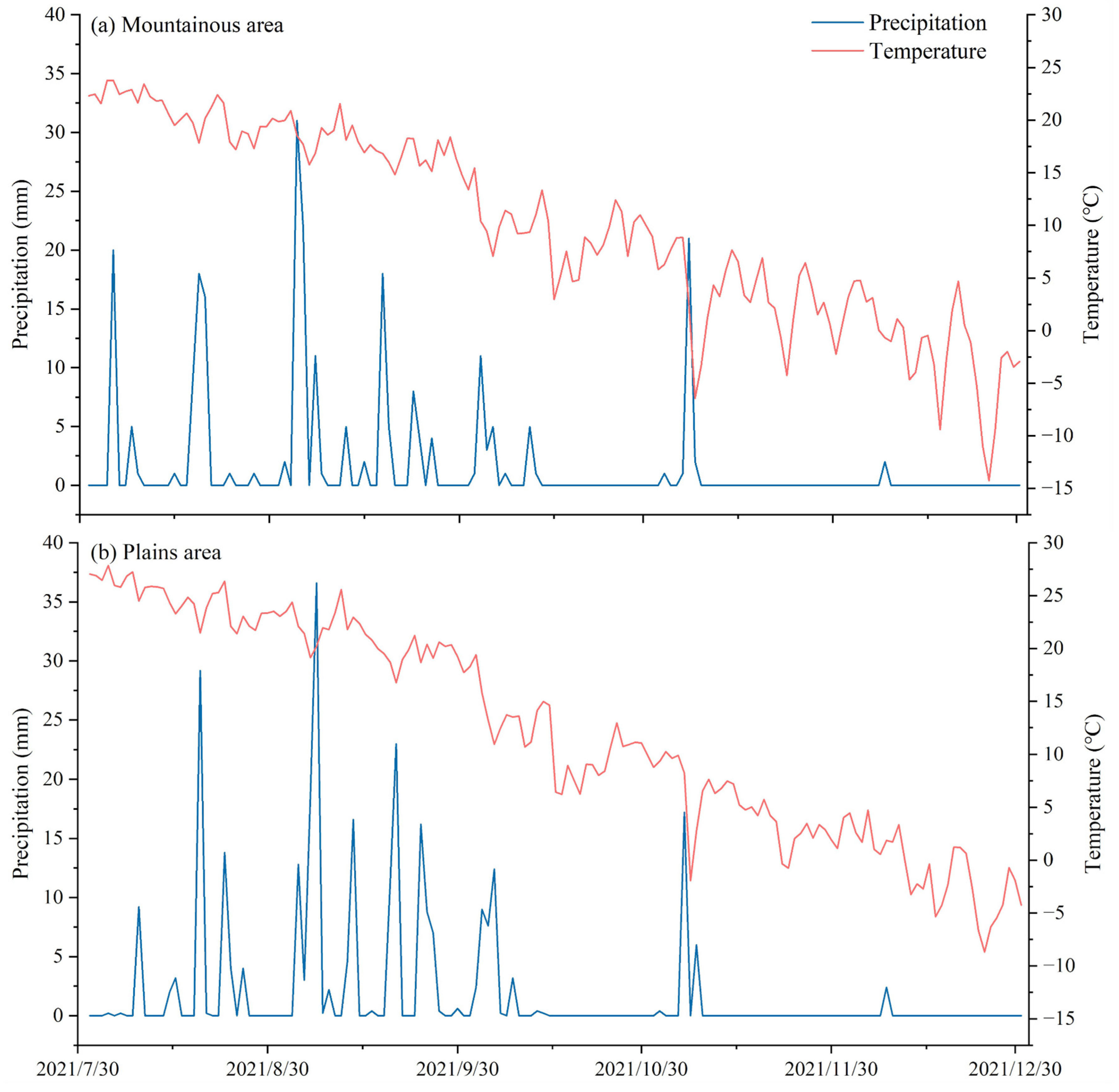
2.1. Study Area

The study area is located in Beijing, China, where the average annual temperature is 10–12 °C, and rainfall is concentrated in the summer, accounting for about 70%~80% of the annual precipitation. There are significant wet and dry seasons, with a rainy season from June to September and a dry season in the other months.
The selected plots in mountainous and plain areas were the pure plantation forests of P. tabuliformis and A. truncatum, and the selected plots were all 15–20 years old. The densities of P. tabuliformis and A. truncatum were 1065 trees/hm2 and 1605 trees/hm2, respectively, in mountainous areas, and 800 trees/hm2 in plain areas.
The study area includes mountainous and plains areas (Figure 1). The mountainous area is located in Badaling Forest Farm, Yanqing District, Beijing, China (40°19′48″ N, 116°1′12″ E), and most of the entire area is mountainous, with an altitude of 750 m. The local climate is continental subhumid, characterized by an average annual temperature of 9.4 °C and an average annual precipitation of 430 mm. The soil type is montane brown soil. The soil content of gravel in the study area is large, and the soil is thin. The plains area is located in Gongqing Forest Farm, Shunyi District, Beijing (40°6′19″ N, 116°42′44″ E). The terrain is flat, and the altitude is 29 m. The local climate is continental subhumid, characterized by an average annual temperature of 11.5 °C and an average annual precipitation of 625 mm. The soil is sandy and has good permeability but poor water retention capacity.

2.2. Experimental Design and Sample Collection

The main meteorological factor data of the study area were based on meteorological stations inside and outside the forest, and the long-term positioning meteorological data were observed. The soil moisture observation system was set up in the sampling area for the real-time observation of 0–100 cm soil moisture change, including the EM50 data collector and the probe of the soil volume moisture measurement system, ECH20–5TE. The soil-drilling method was used to determine the mass water content of each layer of soil, and then the product of soil bulk weight and mass water content of each layer was used to calculate the soil volume water content to correct the soil volume water content measured by the instrument.
Samples of precipitation, soil water, and xylem water were collected in the study area (Figure 1) on sunny days every month from August to December 2021. We chose two sample plots (20 m × 20 m) for each site in the mountains and plains. In pure forest plots of P. tabuliformis and A. truncatum, we chose three trees that were about the same age and in good growth conditions for analysis. For each date, three replicates per sample were selected from every tree. In the case of mature branches (non-green branches, 0.3 to 0.6 cm in diameter), the procedure involves excising the epidermis and phloem while preserving the xylem tissue, followed by immediate placement into clean polyethylene bottles (50 mL). These bottles were then hermetically sealed with parafilm, stored, and subjected to freezing conditions. The mountainous area had a soil depth of 100 cm, and trees with the same root depths were selected in the plains area. Soil samples were obtained from three distinct sampling points in close proximity to the selected trees using a soil auger. Samples were collected at varying depths, namely, 0–20 cm, 20–40 cm, 40–60 cm, 60–80 cm, and 80–100 cm. Furthermore, three replicates were procured per sample from each of the aforementioned layers. A subset of the soil samples was retained in a refrigerated environment at a temperature of 4 °C for subsequent isotopic analysis. The remaining soil samples were sealed and subjected to gravimetric soil moisture measurements, which were determined by drying the samples in an oven for a duration of one day. Following each precipitation event, rainwater was procured from the weather station and deposited into clean polyethylene bottles with a volume of 50 mL. Subsequently, each sample was carefully wrapped in parafilm and immediately subjected to freezing conditions to preclude evaporation fractionation [24].

2.3. Laboratory Analysis

The Laboratory of Ecohydrological Processes and Mechanisms at Beijing Forestry University is where we did the isotopic analysis of δ2H and δ18O for our study. An automatic vacuum condensing extraction system (LI-2100, LICA, Beijing, China) was used to extract moisture samples from soil and branch samples. Prior to extraction, the bark encompassing each branch was meticulously excised using scissors, while simultaneously ensuring the absence of any green parts on the plant’s branches. The isotopic ratio of all liquid water samples was determined using a Liquid Water Isotope Analyzer (LWIA) instrument (DLT-100, LGR, Mountain View, State of California, USA). The hydrogen and oxygen isotope ratios in the final water samples were calculated as thousandths of the Vienna Standard Mean Ocean Water (V-SMOW) using the following formula:
δ = R s a m p l e R s t a n d a r d R s t a n d a r d × 1000
where the hydrogen (oxygen) isotope ratios of the water sample and the V-SMOW were represented by Rsample and Rstandard, respectively, δ2H values had a test accuracy of ±1‰, and δ18O values had a test accuracy of ±0.3‰. Moreover, the LWIA-Spectral Contamination Identifier v1.0 was employed to correct the measurement data for spectral contamination.
Soil water content was determined using the dry weight method. Soil samples were taken to the laboratory and weighed with an electronic balance (0.0001 g) while still wet. The samples were then dried in a blast drying oven at a constant temperature of 105 ± 2 °C for about 24 h until they reached a constant weight. After cooling, the dry soil samples were weighed again, and the soil water content was calculated using the following formula:
W = W 1 W 2 W 2 W 0 × 100 %
where W1 represents the weight of the wet soil plus the aluminum box before drying (g), W2 represents the weight of the dry soil plus the aluminum box after drying (g), and W0 represents the weight of the aluminum box (g).

2.4. Data Analysis

The Bayesian isotope mixing model (MixSIAR) was used to determine the uptake fractions of water sources [25], and the software package MixSIAR (version 3.1.7) [26] was used for the analysis of source water contributions to the plant isotopic composition. MixSIAR is a flexible framework for creating mixing models based on the Bayesian theory [25,27,28,29,30] and the software package, whose model fully considers the potential uncertainties of the isotope values of the mixture (xylem water) and the contribution source (soil water) as well as the uncertainties caused by the over-parameterization of the contribution source, integrates the advantages of MixSIR and SIAR models, and adds modules such as the input form of the original source of the multiple isotopes of the contribution source and the poor classification variables of random effects. The accuracy of quantitative calculation of plant water source and its contribution ratio was significantly improved [26]. It is available for download from the Comprehensive R Archive Network site (CRAN) at http://cran.r-project.org/ (accessed on 1 December 2022).
Statistical analyses were carried out using the software package SPSS (version 24.0; SPSS, Inc., Chicago, IL, USA). We used one-way ANOVA and Tukey’s post hoc least significant difference (LSD) test (p < 0.05) to see if there were any significant differences between the isotopic values of precipitation, xylem water, and soil water. All figures were created using Origin 2018 (OriginLab Corp., Northampton, MA, USA).

3. Results

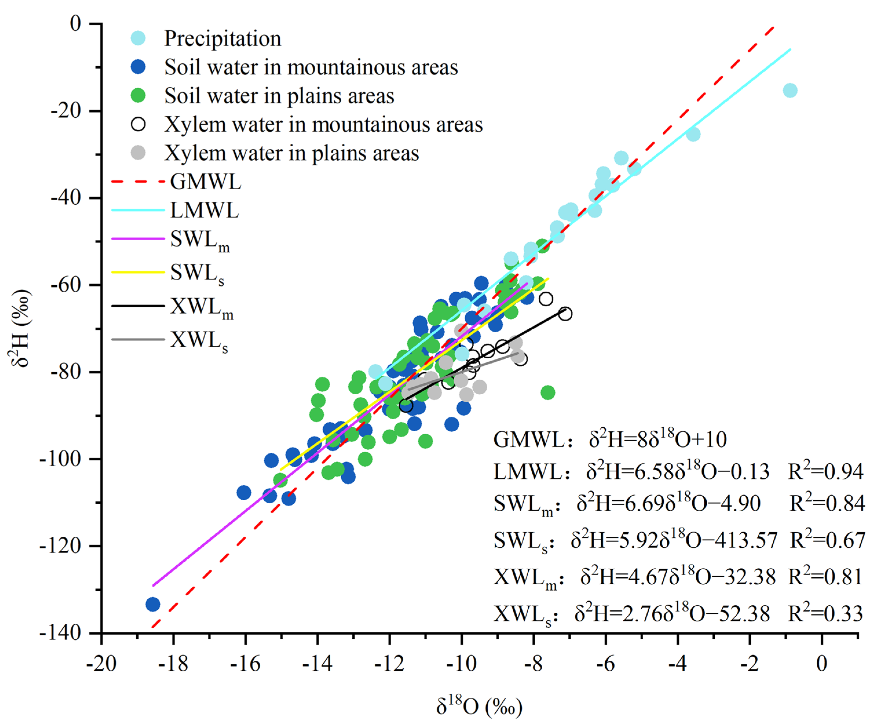
3.1. Isotopic Characteristics of Different Water Bodies

During the sampling period, the precipitation trends in the mountainous and plains areas were essentially the same, with the precipitation concentrated in August and September, and the precipitation significantly decreased during the nongrowing season. Based on the δ2H and δ18O values of the precipitation samples, a local meteoric water line (LMWL) was fitted for the period from August to December in Beijing (Figure 2), and its equation was δ2H = 6.58δ18O − 0.13. In comparison with the slope and intercept of the global meteoric water line (GMWL) equation (δ2H = 8δ18O + 10 [31]), the slope and intercept of the derived LMWL equation were found to be lower (6.58 < 8; −0.13 < 10; Figure 2). The linear relationships between the δ2H and δ18O values of the soil and xylem water samples from August to December were determined and referred to as the soil water line (SWL) and the xylem water line (XWL), respectively (Figure 2). The slope and intercept of the SWL and XWL in the plains area were found to be lower than those of the LMWL. Conversely, the slopes and intercepts of SWL and XWL were higher in the mountainous area.
The isotopic trends of δ2H and δ18O were generally similar across various water bodies; thus, the δ18O value was utilized to investigate the isotopic properties of the diverse water sources. The range of δ18O was from −12.38 to −0.87 for precipitation, from −18.57 to −8.18 for soil water in the mountainous area, from −15.02 to −7.60 for soil water in the plains area, from −11.54 to −7.12 for xylem water in the mountainous area, and from −11.47 to −8.44 for xylem water in the plains area. In particular, the δ18O values exhibited the greatest variation in precipitation, followed by soil water, whereas the changes in δ18O values of xylem water were comparatively minor.

3.2. Variation in Soil Water Content in Different Areas

The soil water content showed variations across seasons and soil depths (Figure 3). The monthly variation in the soil water content of the two areas for the deep layer was stable during the sampling period. The changes in soil water content in the mountainous area were more pronounced than those in the plains area during different months, and the variation in the water content during different months in the plains area was essentially the same. The soil moisture content in the mountainous and plains areas varied from 7.02% to 16.20% and from 6.05% to 9.18%, respectively. The soil water content of the shallow layer in the mountainous area significantly varied compared with the other layers; the results for SWC significantly differed (p < 0.05). During the sampling period, rainfall mainly occurred in August and September (Figure 4). Compared with other months, the changes in soil water content at various depths were more noticeable in August and September. The highest rainfall was recorded in September, and the surface soil water content in the mountainous area was higher than that in other months. The surface soil water contents of P. tabulaeformis and A. truncatum in September were 15.04% and 21.50%, respectively. However, the surface soil water in the plains area was relatively stable. Over time, the soil water content of the shallow layer in the mountainous area gradually tended to be stable from higher than that of the deep layer. In the plains area, the soil water content in the deeper layer of A. truncatum was found to be greater than that in the shallower layer.

3.3. Isotopic Characteristics of Soil Water

During the sampling period, the δ18O value for soil water in the study area changed to a certain extent (Figure 5). In both the mountainous and plains areas, the variation in the δ18O value for soil water was noticeable in the shallow layer and was stable in the deep layer. However, the δ18O value for soil water showed a gradual decrease with the increasing soil depth in the plains area, whereas in the mountainous area, the variation in the δ18O value for soil water at different depths differed across months. Both mountainous and plains areas showed marked differences in August, September, and October and relatively stable values in November and December. However, the degree of variation in soil water isotopes during different months in the mountainous area was more noticeable than that in the plains area. The δ18O value for soil water in the mountainous area was depleted in 0–20 cm soil in August and September and enriched in October. The variation in the plains area was generally the same, with enrichment in the 0–20 cm layer and a stable δ18O value for soil water at 20–100 cm.

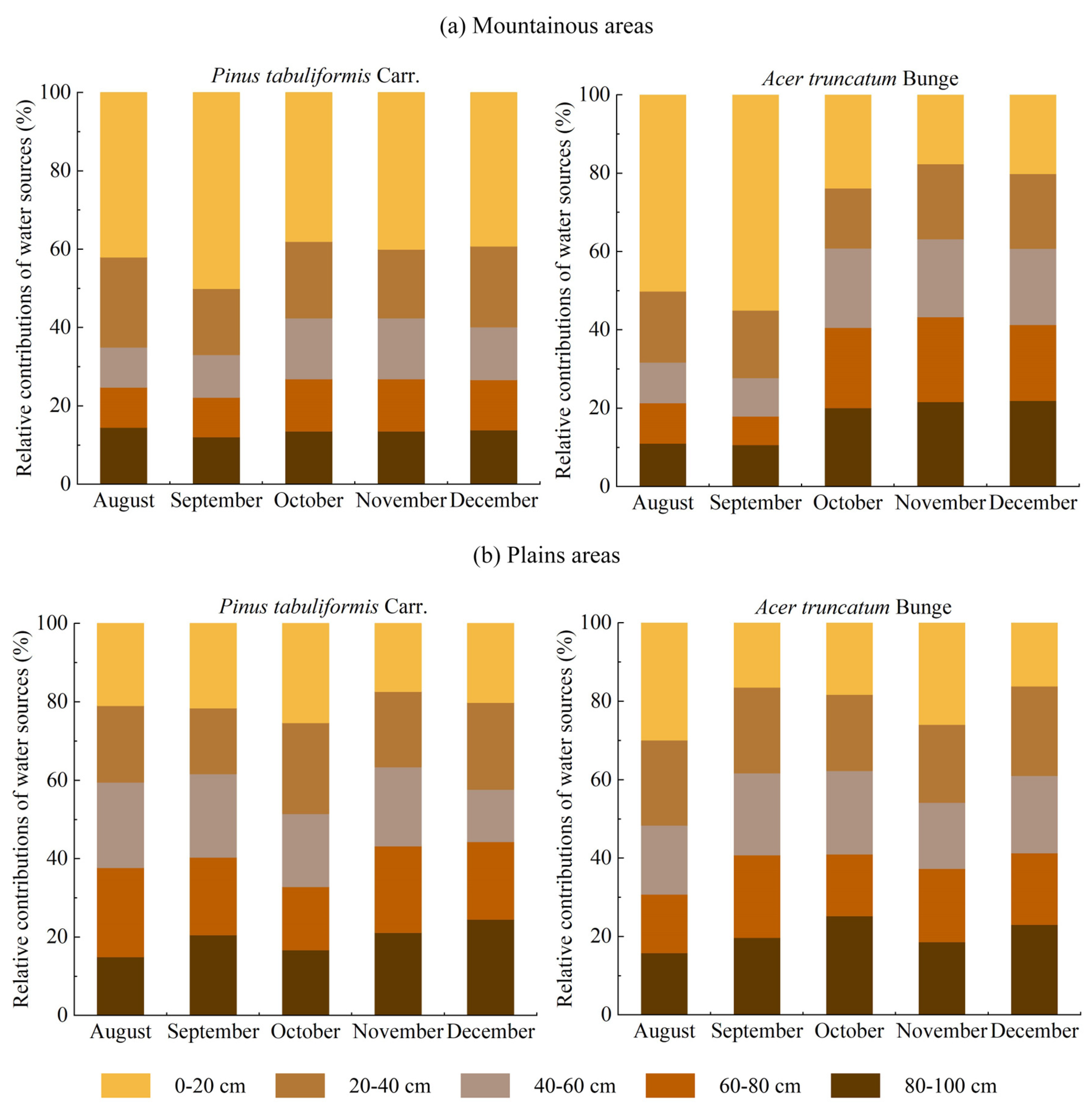
3.4. Water Sources for Typical Tree Species in Different Areas

The MixSIAR model was used to calculate the contribution rates of different types of potential water sources to typical tree species in the mountainous and plains areas (Figure 6). The contribution rate of potential water sources to tree species exhibited variations in the different areas (Figure 6).
During the sampling period, the main water source for P. tabuliformis in the mountainous areas was shallow soil water, and the main water source for A. truncatum in the mountainous area was shallow soil water to deep soil water. However, the main water source for typical tree species in the plains area was relatively stable, the contribution rate of soil water for each layer did not change much over different months, and the middle and deep soil water were mainly used. Overall, the typical tree species showed a higher utilization rate for deep soil water in the plains area than in the mountainous area and a higher utilization rate of surface soil water in the mountainous area than in the plains area.
During different growing stages, divergent water use strategies were detected for the two tree species in mountainous and plains areas (Figure 6). During the sampling period, rainfall was concentrated in August and September (Figure 4). The xylem water of A. truncatum in the mountainous area mainly originated from 0~20 cm soil water, with a contribution rate of 50.2%~55.0%. In October, November, and December, the 60~100 cm soil water was the main water source, with a contribution rate of 60.8%~63.2%. The xylem water sources of the typical tree species in the mountainous area were significantly different in August and September and in October, November, and December, and the contribution rate of deep soil water increased. The xylem water of P. tabuliformis was primarily derived from the 0–20 cm soil water during various months, with a contribution rate ranging from 37.8% to 50.0%. However, soil water from 60~100 cm was the main water source for the typical tree species over different months, with a contribution rate ranging from 48.3% to 65.1%. Overall, the difference in water resources used by the typical tree species at different growing stages in the mountainous area was larger than that in the plains area.

4. Discussion

4.1. Soil Water Content Variation and Stable Isotope Distribution in Different Areas

The soil water content and isotopic composition significantly varied over different areas, months, and soil depths. These results suggest that SWC and isotopic composition are largely influenced by evaporation and rainfall recharge [32]. The results suggested that the response of shallow soil water to precipitation and evaporation was more sensitive than that of deep soil water, and there were significant differences between shallow soil water content and deep soil water content. This is because the water output of the shallow soil in the mountainous area is relatively large during the infiltration process, and water infiltration into the deep layer is relatively low [33]. However, there was little difference between the shallow soil and the deep soil in the plains area because the soil of the plains area is sandy, and the evaporation from the surface soil is connected with the atmosphere. In addition, the temperature in the plains area is consistently higher than that in the mountainous area, and the influence of evaporation is also more severe than that of the surface soil in the mountainous area, which neutralizes the influence of precipitation. This finding indicates that soil water is spatiotemporally heterogeneous under the influence of precipitation and evaporation, but different soil layers are affected to different degrees [23].
Under the influence of evaporation and precipitation, the isotopic fractionation of stable hydrogen and oxygen isotopes in soil water varies with respect to the depth of occurrence. The variation in δ18O in the deep layer (40~100 cm) was less than that in the shallow layer (0~40 cm). This is because surface and shallow soil water is significantly influenced by the combined effects of precipitation and evaporation, while deep soil water is relatively less affected by these factors [17]. Therefore, differences in the δ18O values for soil water decreased with increasing soil depth [34]. In a study of the stable isotopic composition of different water bodies in the western part of the Loess Plateau, the study conducted by Che et al. found that under the dual influences of precipitation infiltration and evaporation, water isotopic fractionation was noticeable in the shallow soil, while the water isotope contents in the deep soil were relatively stable [35]. Similar results were obtained in this study, showing that in the mountains in August and September, the isotopic composition of the soil water was positively related to an increasing soil depth because rainfall was abundant in August and September, and the soil water of hydrogen and oxygen isotope dilution, which inhibits the isotope enrichment of shallow soil evaporation [32]. Following that, there has been a gradual decrease in precipitation levels, which has resulted in a reduction in the impact of soil depth on the δ18O value. However, in the plains area, the isotopic composition of the soil water during the dry season showed a negative change with an increasing soil depth, which was due to a strong evaporation of the surface soil and the attenuation with the change in depth [36,37].

4.2. Water Sources of Typical Tree Species in Different Areas

The results of the present study investigate that the contribution rate of potential water sources to tree species exhibited variations in the different areas (Figure 6). From August to December, the main water source for P. tabuliformis in the mountainous areas was shallow soil water, and the main water source for A. truncatum in the mountainous area was shallow soil water to deep soil water. However, the main water source for typical tree species in the plains area was relatively stable, the contribution rate of soil water for each layer did not change much over different months, and the middle and deep soil water were mainly used.
From August to December, P. tabuliformis primarily obtains water from shallow soil sources in the mountainous area. This can be attributed to the fact that plant uptake of upper soil water is influenced by the nutrient content of the shallow soil [38], and the absorption of soil nutrients can promote the absorption of water by roots to a certain extent [39]. The soil nutrient content in this study area decreased with an increasing soil depth [40]. In addition, plants consume less energy to absorb soil water from the surface layer than from the deep layer [41]. Thus, in mountainous regions, P. tabuliformis primarily absorbs water from the shallow layer of soil. This plasticity in water uptake by these trees is the result of the priority given to the soil water uptake via roots [42].
Precipitation mainly occurred in August and September, and shallow soil water was the main water source for A. truncatum in the mountainous area. Sufficient precipitation and surface soil water are necessary for plant growth [43]. The main water source in October, November, and December was deep soil water. Due to lower levels of precipitation and increased evaporation during the dry season, the surface soil water content is insufficient for the normal growth of plants. The study undertaken by Mooney et al. showed that when the upper soil becomes dry and water is unavailable, plants absorb water from deeper regions [44]. When faced with drought stress, the root systems of A. truncatum in the mountainous area develop hydrotropism and geotropism, which induce plants to seek more stable and reliable deep soil water sources to maintain their growth and development during the dry season [45,46]. Trees that can switch water sources may have a competitive and survival advantage in seasonally arid environments because they can make the full use of the available water to maintain their normal physiological activities [47,48].
However, deep soil water is the main water source absorbed and utilized by typical tree species in the plain areas, regardless of the season. It is possible that deep soil water can be used as a relatively stable and long-term water supply source in seasonally dry areas [49]. Precipitation mainly occurs in August and September; after rainfall, both the deep and shallow soil moisture levels are sufficient and can meet the normal water supply needs of plants [48], but the sampling time is sunny days in the pre-rain period, during which the soil may be affected by a short drought period caused by long-term insufficient rainfall [50], and the deep surface soils are less affected by intense evaporation, and deep soil water can therefore provide a relatively stable source of water over a long period of time. However, during October, November, and December, the precipitation levels are lower, and the sandy soil in the plains area has poor water holding capacity; thus, the surface soil water evaporates, and plants are constrained to solely utilizing their deeper roots for soil water absorption [48].

4.3. Implications for Forest Management in the Mountainous and Plains Areas of Beijing

In conclusion, during the sampling period, P. tabuliformis mainly absorbed shallow soil water in the mountains, while A. truncatum transitioned from relying on shallow soil water as its water source to utilizing deep soil water, embodying the high climate adaptability of A. truncatum. This is also one of the reasons for the wide distribution and abundant growth of A. truncatum in the typical seasonally drought-affected regions of Beijing. This study used a reference value for the selection of tree species and for the long-term management and planning of ecological afforestation in seasonally arid mountainous areas. However, P. tabuliformis and A. truncatum mainly absorb and utilize deep soil water to maintain their normal physiological activities in the plains areas, and water competition can be avoided if other tree species that also depend on deep soil water are not planted. Even within the same tree species, water use strategies may be different in the mountainous and plains areas; thus, tree species selection must be targeted during afforestation and forestry management in the mountainous and plains areas in the future, which can serve as a valuable reference for guiding forestry management practices in analogous forest ecosystems.
One limitation of this study is the short sampling period. Further studies are needed with more sampling periods and more plant species to determine seasonal water use patterns and plant‒soil water cycle processes to gain a deeper understanding of the discrepancies in water utilization patterns exhibited by typical tree species in the mountainous and plains terrains throughout both the active and dormant phases. In addition, although we avoided areas with long-term tending and management measures when selecting sampling sites, the Gongqing Forest Farm belongs to an urban park, and the trees in it will be affected by human activities and pollution, resulting in certain limitations in the research results. Furthermore, the methods for more accurately assessing the water sources of urban trees require further extensive and in-depth research.

5. Conclusions

The water absorption characteristics of typical tree species from the growing season to the nongrowing season are significantly different in different areas of Beijing. The xylem water of P. tabuliformis primarily originated from the surface soil water (0~20 cm) throughout both the growth and nongrowing seasons. During the nongrowing season, precipitation levels were low. To meet the plant water demand for growth, deep soil water (60~100 cm) utilization was increased. However, in the plains area, the water sources for P. tabuliformis and A. truncatum showed little variation over the growing season and nongrowing season, and the source was mainly deep soil water (60~100 cm). In the mountainous area, unlike P. tabuliformis, A. truncatum can alter its water use patterns according to the precipitation and soil water conditions, indicating their strong environmental adaptability. Due to the differences in terrain, climate, soil, and other conditions between the mountains and plains, the water use strategies of the typical tree species are significantly different. In order to facilitate the restoration and reconstruction of forest vegetation, as well as the management and maintenance of the Beijing region, it is imperative to carefully choose tree species that are well suited to the specific water conditions prevailing in different local locations.

Author Contributions

Conceptualization, T.Z. and Y.C.; Investigation, Y.C. and H.Z. (Hengshuo Zhang); Data curation, Y.C.; Resources, H.Z. (Hongli Zhang), L.Z., A.W., Q.C. and J.S.; Visualization, Y.C.; Writing—original draft, Y.C.; Writing—review and editing, T.Z., Y.Y. and D.W. All authors have read and agreed to the published version of the manuscript.

Funding

This research was funded by the National Science and Technology Achievements Outreach Program of National Forestry Administration (no. [2019]03).

Data Availability Statement

Data will be made available upon reasonable request to the corresponding author.

Acknowledgments

We extend our sincere gratitude to our colleagues at Beijing Forestry University, Beijing Badaling Forest Farm Management Office, and Soil and Water Conservation Monitoring Center, Ministry of Water Resources, for their assistance in fieldwork, laboratory analysis, and data processing.

Conflicts of Interest

The authors declare that the research was conducted in the absence of any commercial or financial relationships.

References

  1. Wang, K.Q.; Wang, B.T.; Wang, B.R.; Gao, H.P. Studies on the growth of forests with different density in the system of afforestation by water-harvesting. Sci. Silvae Sin. 2002, 38, 54–60. (In Chinese) [Google Scholar]
  2. Xu, Q.; Ji, C.L.; Wang, H.Y.; Li, Y. Use of stable isotopes of hydrogen, oxygen and carbon to identify water use strategy by plants. World For. Res. 2009, 22, 41–46. (In Chinese) [Google Scholar]
  3. Yu, Y.; Hua, T.; Chen, L.D.; Zhang, Z.Q.; Paulo, P. Divergent Changes in Vegetation Greenness, Productivity, and Rainfall Use Efficiency Are Characteristic of Ecological Restoration towards High-Quality Development in the Yellow River Basin, China. Engineering 2023. [Google Scholar] [CrossRef]
  4. Grant, G.E.; Dietrich, W.E. The frontier beneath our feet. Water Resour. Res. 2017, 53, 2605–2609. [Google Scholar] [CrossRef]
  5. Penna, D.; Hopp, L.; Scandellari, F.; Allen, S.T.; Benettin, P.; Beyer, M.; Geris, J.; Klaus, J.; Marshall, J.D.; Schwendenmann, L.; et al. Ideas and perspectives: Tracing terrestrial ecosystem water fluxes using hydrogen and oxygen stable isotopes—Challenges and opportunities from an interdisciplinary perspective. Biogeosciences 2018, 15, 6399–6415. [Google Scholar] [CrossRef]
  6. Rothfuss, Y.; Javaux, M. Reviews and syntheses: Isotopic approaches to quantify root water uptake: A review and comparison of methods. Biogeosciences 2017, 14, 2199–2224. [Google Scholar] [CrossRef]
  7. Duan, D.Y.; Ouyang, H. Application of stable hydrogen and oxygen isotope in analyzing plant water use sources. Ecol. Environ. 2007, 16, 22–30. (In Chinese) [Google Scholar]
  8. Grossiord, C.; Sevanto, S.; Dawson, T.E.; Adams, H.D.; Collins, A.D.; Dickman, L.T.; Newman, B.D.; Stockton, E.A.; McDowell, N.G. Warming combined with more extreme precipitation regimes modifies the water sources used by trees. New Phytol. 2017, 213, 584–596. [Google Scholar] [CrossRef]
  9. Yang, B.; Wen, X.F.; Sun, X.M. Seasonal variations in depth of water uptake for a subtropical coniferous plantation subjected to drought in an East Asian monsoon region. Agric. For. Meteorol. 2015, 201, 218–228. [Google Scholar] [CrossRef]
  10. Antunes, C.; Diaz-Barradas, M.C.; Zunzunegui, M.; Vieira, S.; Maguas, C. Water source partitioning among plant functional types in a semi-arid dune ecosystem. J. Veg. Sci. 2018, 29, 671–683. [Google Scholar] [CrossRef]
  11. Zhang, Y.C.; Sun, H.Y.; Shen, Y.J.; Qi, Y.Q. Application of Hydrogen and Oxygen Stable Isotopes Technique in the Water Depletion of Ecosystems. Sci. Geogr. Sin. 2012, 32, 289–293. (In Chinese) [Google Scholar]
  12. Wei, F.L.; Li, S.C.; Yu, W.S.; Xie, A.L.; Hou, W.Y. A review of stable isotope in precipitation studies based on bibliometric and social network analysis. Acta Ecol. Sin. 2019, 39, 2634–2643. (In Chinese) [Google Scholar]
  13. Dawson, T.E.; Ehleringer, J.R. Streamside trees that do not use stream water. Nature 1992, 350, 335–337. [Google Scholar] [CrossRef]
  14. Zimmermann, U.; Munnich, K.O.; Roether, W.; Kreutz, W.; Schubach, K.; Siegel, O. Tracers determine movement of soil moisture and evapotranspiration. Science 1966, 152, 346–347. [Google Scholar] [CrossRef] [PubMed]
  15. Ellsworth, P.Z.; Williams, D.G. Hydrogen isotope fractionation during water uptake by woody xerophytes. Plant Soil 2007, 291, 93–107. [Google Scholar] [CrossRef]
  16. Liu, Z.Q.; Yu, X.X.; Jia, G.D.; Jia, J.B.; Lou, Y.H.; Lu, W.W. Contrasting water sources of evergreen and deciduous tree species in rocky mountain area of Beijing, China. Catena 2017, 150, 108–115. [Google Scholar] [CrossRef]
  17. Chen, Z.X.; Wang, G.H.; Pan, Y.H.; Yang, X.L.; Shen, Y.Y. Water use patterns differed notably with season and slope aspect for Caragana korshinskii on the Loess Plateau of China. Catena 2021, 198, 105028. [Google Scholar] [CrossRef]
  18. Ma, X.F.; Zhu, J.T.; Wang, Y.; Yan, W.; Zhao, C.Y. Variations in water use strategies of sand-binding vegetation along a precipitation gradient in sandy regions, northern China. J. Hydrol. 2021, 600, 126539. [Google Scholar] [CrossRef]
  19. Zhang, F.H.; Jia, W.X.; Zhu, G.F.; Zhang, Z.Y.; Shi, Y.; Yang, L.; Xiong, H.; Zhang, M.M. Using stable isotopes to investigate differences of plant water sources in subalpine habitats. Hydrol. Process. 2022, 36, e14518. [Google Scholar] [CrossRef]
  20. Beijing Municipal and Parks Bureau. Available online: https://yllhj.beijing.gov.cn/ztxx/lhysh/st/202302/t20230221_2920979.shtml (accessed on 25 September 2023).
  21. Christensen, C.W.; Hayashi, M.; Bentley, L.R. Hydrogeophysical survey of groundwater flow pathways in an alpine headwater basin. In Proceedings of the Near Surface Geoscience 2016—22nd European Meeting of Environmental and Engineering Geophysics, Barcelona, Spain, 4–8 September 2016. [Google Scholar]
  22. Xia, J.; Qiu, B.; Li, Y.Y. Water resources vulnerability and adaptive management in the Huang, Huai and Hai river basins of China. Water Int. 2012, 37, 523–536. [Google Scholar] [CrossRef]
  23. Wang, X.; Jia, G.D.; Deng, W.P.; Liu, Z.Q.; Liu, Z.H.; Qiu, G.F.; Li, W.L. Long-term water use characteristics and patterns of typical tree species in seasonal drought regions. Chin. J. Appl. Ecol. 2021, 32, 1943–1950. (In Chinese) [Google Scholar]
  24. West, A.G.; Patrickson, S.J.; Ehleringer, J.R. Water extraction times for plant and soil materials used in stable isotope analysis. Rapid Commun. Mass Spectrom. 2006, 20, 1317–1321. [Google Scholar] [CrossRef]
  25. Parnell, A.C.; Inger, R.; Bearhop, S.; Jackson, A.L. Source Partitioning Using Stable Isotopes: Coping with Too Much Variation. PLoS ONE 2010, 5, e9672. [Google Scholar] [CrossRef] [PubMed]
  26. Stock, B.C.; Semmens, B.X. MixSIAR GUI User Manual, Version 3.1. 2013. Available online: https://github.com/brianstock/MixSIAR (accessed on 1 December 2022).
  27. Bowen, G.J.; Putman, A.; Brooks, J.R.; Bowling, D.R.; Oerter, E.J.; Good, S.P. Inferring the source of evaporated waters using stable H and O isotopes. Oecologia 2018, 187, 1025–1039. [Google Scholar] [CrossRef] [PubMed]
  28. Erhardt, E.B.; Bedrick, E.J. A Bayesian framework for stable isotope mixing models. Environ. Ecol. Stat. 2013, 20, 377–397. [Google Scholar] [CrossRef]
  29. Moore, J.W.; Semmens, B.X. Incorporating uncertainty and prior information into stable isotope mixing models. Ecol. Lett. 2008, 11, 470–480. [Google Scholar] [CrossRef]
  30. Parnell, A.C.; Phillips, D.L.; Bearhop, S.; Semmens, B.X.; Ward, E.J.; Moore, J.W.; Jackson, A.L.; Grey, J.; Kelly, D.J.; Inger, R. Bayesian stable isotope mixing models. Environmetrics 2013, 24, 387–399. [Google Scholar] [CrossRef]
  31. Craig, H. Isotopic Variations in Meteoric Waters. Science 1961, 133, 1702–1703. [Google Scholar] [CrossRef]
  32. Rossatto, D.R.; Silva, L.D.R.; Villalobos-Vega, R.; Sternberg, L.D.L.; Franco, A.C. Depth of water uptake in woody plants relates to groundwater level and vegetation structure along a topographic gradient in a neotropical savanna. Environ. Exp. Bot. 2012, 77, 259–266. [Google Scholar] [CrossRef]
  33. Wu, H.W.; Li, X.Y.; Jiang, Z.Y.; Li, J.; Zheng, X.R.; Zhao, D.Z. Variations in water use for Achnatherum splendens in Lake Qinghai watershed, based on δD and δ18O. Acta Ecol. Sin. 2015, 35, 8174–8183. (In Chinese) [Google Scholar]
  34. Qiu, X.; Zhang, M.; Wang, S. Preliminary research on hydrogen and oxygen stable isotope characteristics of different water bodies in the Qilian Mountains, northwestern Tibetan Plateau. Environ. Earth Sci. 2016, 75, 1491. [Google Scholar] [CrossRef]
  35. Che, C.W.; Zhang, M.J.; Argiriou, A.A.; Wang, S.J.; Du, Q.Q.; Zhao, P.P.; Ma, Z.Z. The Stable Isotopic Composition of Different Water Bodies at the Soil-Plant-Atmosphere Continuum (SPAC) of the Western Loess Plateau, China. Water 2019, 11, 1742. [Google Scholar] [CrossRef]
  36. Cheng, X.L.; An, S.Q.; Li, B.; Chen, J.Q.; Lin, G.H.; Liu, Y.H.; Luo, Y.Q.; Liu, S.R. Summer rain pulse size and rainwater uptake by three dominant desert plants in a desertified grassland ecosystem in northwestern China. Plant Ecol. 2006, 184, 1–12. [Google Scholar] [CrossRef]
  37. Gazis, C.; Feng, X. A stable isotope study of soil water: Evidence for mixing and preferential flow paths. Geoderma 2004, 119, 97–111. [Google Scholar] [CrossRef]
  38. Amin, A.; Zuecco, G.; Geris, J.; Schwendenmann, L.; McDonnell, J.J.; Borga, M.; Penna, D. Depth distribution of soil water sourced by plants at the global scale: A new direct inference approach. Ecohydrology 2020, 13, e2177. [Google Scholar] [CrossRef]
  39. Goldsmith, G.R.; Munoz-Villers, L.E.; Holwerda, F.; McDonnell, J.J.; Asbjornsen, H.; Dawson, T.E. Stable isotopes reveal linkages among ecohydrological processes in a seasonally dry tropical montane cloud forest. Ecohydrology 2012, 5, 779–790. [Google Scholar] [CrossRef]
  40. February, E.C.; Higgins, S.I. The distribution of tree and grass roots in savannas in relation to soil nitrogen and water. South Afr. J. Bot. 2010, 76, 517–523. [Google Scholar] [CrossRef]
  41. Deng, W.P.; Yu, X.X.; Jia, G.D.; Li, Y.J.; Liu, Y.J. Water Sources of Three Typical Plants in the Beijing Mountain Areas in Rainy Season. Arid. Zone Res. 2014, 31, 649–657. (In Chinese) [Google Scholar]
  42. Eggemeyer, K.D.; Awada, T.; Harvey, F.E.; Wedin, D.A.; Zhou, X.; Zanner, C.W. Seasonal changes in depth of water uptake for encroaching trees Juniperus virginiana and Pinus ponderosa and two dominant C-4 grasses in a semiarid grassland. Tree Physiol. 2009, 29, 157–169. [Google Scholar] [CrossRef]
  43. Chen, X.L.; Chen, Y.N.; Chen, Y.P. Relationship among water use of different plants in Heihe River riparian forests. Chin. J. Eco-Agric. 2014, 22, 972–979. (In Chinese) [Google Scholar]
  44. Mooney, H.A.; Gulmon, S.L.; Rundel, P.W.; Ehleringer, J. Further observations on the water relations of Prosopis tamarugo of the northern Atacama desert. Oecologia 1980, 44, 177–180. [Google Scholar] [CrossRef]
  45. Poot, P.; Lambers, H. Shallow-soil endemics: Adaptive advantages and constraints of a specialized root-system morphology. New Phytol. 2008, 178, 371–381. [Google Scholar] [CrossRef] [PubMed]
  46. Zhou, H.; Zhao, W.Z.; Zheng, X.J.; Li, S.J. Root distribution of Nitraria sibirica with seasonally varying water sources in a desert habitat. J. Plant Res. 2015, 128, 613–622. [Google Scholar] [CrossRef]
  47. Dawson, T.E.; Pate, J.S. Seasonal water uptake and movement in root systems of Australian phraeatophytic plants of dimorphic root morphology: A stable isotope investigation. Oecologia 1996, 107, 13–20. [Google Scholar] [CrossRef] [PubMed]
  48. Ehleringer, J.R.; Dawson, T.E. Water uptake by plants: Perspectives from stable isotope composition. Plant Cell Environ. 1992, 15, 1073–1082. [Google Scholar] [CrossRef]
  49. Liu, Z.Q.; Yu, X.X.; Jia, G.D.; Jia, J.B.; Lou, Y.H.; Zhang, K. Water Use Characteristics of Platycladus orientalis and Quercus variabilis in Beijing Mountain Area. Sci. Silvae Sin. 2016, 52, 22–30. (In Chinese) [Google Scholar]
  50. Liu, Z.Q.; Yu, X.X.; Jia, G.D.; Li, H.Z.; Lu, W.W. Water source of typical plants in rocky mountain area of Beijing, China. Chin. J. Appl. Ecol. 2017, 28, 2135–2142. (In Chinese) [Google Scholar]
Figure 1. Location of the study area.
Forests 14 02277 g001
Figure 2. Relationships between δ2H and δ18O in different water bodies. GMWL: global meteoric water line; LMWL: local meteoric water line; SWLm: soil water line in mountainous areas; SWLs: soil water line in plains areas; XWLm: xylem water line in mountainous areas; and XWLs: xylem water line in plains areas.
Forests 14 02277 g002
Figure 3. The variation characteristics of SWC in mountainous and plains areas.
Forests 14 02277 g003
Figure 4. Precipitation and temperature variation during the sampling period.
Forests 14 02277 g004
Figure 5. The δ18O values for soil water over different months.
Forests 14 02277 g005
Figure 6. Plant water sources of different areas from August to December.
Forests 14 02277 g006
Disclaimer/Publisher’s Note: The statements, opinions and data contained in all publications are solely those of the individual author(s) and contributor(s) and not of MDPI and/or the editor(s). MDPI and/or the editor(s) disclaim responsibility for any injury to people or property resulting from any ideas, methods, instructions or products referred to in the content.

