


Impact of Repurposing Forest Land on Erosion and Sediment Production—Case Study: Krupanj Municipality—Serbia


Abstract
1. Introduction
2. The Initial Position—A Case Study
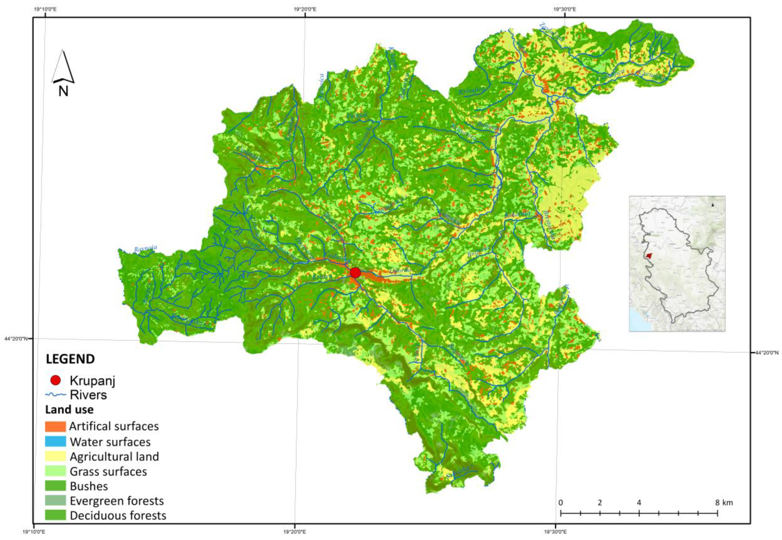
2.1. The Basic Space Use
2.2. Natural Characteristics
- Haplic Cambisol (Dystric)—acidic brown soil on granites and granodiorites are the dominant type in this area. The favourable water and air regime allows a mechanical composition defined as light and sandy. This type of soil is located under the hill beech forest and is characterised by high fertility, which makes it suitable for most forest species;
- Haplic Luvisol (Epidystric)—the evolution of acidic brown soils results in illimerised acidic brown soil, which takes up less surface area. Oak stands are mostly found on it, while it has secondary importance for beeches;
- Leptic Cambisol (Eutric, Clayic)—brown soil, which is found on bituminous and banked limestone, is characterised by lesser depth and a relatively high share of organic matter. Its chemical characteristics make it similar to rendzina, but they are different in terms of mechanical composition as it has the character of clay loam;
- Haplic Cambisol (Dystric, Siltic)—acidic brown soil on Paleozoic shales is formed on acidic rocks with a very shallow humus layer with unfavourable chemical and mechanical characteristics; therefore, it has little production value;
- Haplic Cambisol (Dystric, Skeletic)—brown acidic soil on sandstone is characterised by a pronounced acidity and is formed as a shallow soil with a skeleton, which puts it in the category of soils with good water and air regimes of good production value;
- Haplic Planosol—the soil with unfavourable physical characteristics and a poor water and air regime; parapodzol (pseudo-clay) is a low-fertility soil. The main vegetation growing on it is made up of oak and common hornbeam forests;
- Haplic Fluvisol—alluvial soil occurs in the river Jadar valley as an alluvial sediment. It is a young sediment made by frequent flooding. The groundwater, which is very near the surface, makes this soil characteristic since, during droughts, the water supply to the vegetation is very good, giving the plants enough moisture at times of drought [33,34].
3. Method

4. Results
4.1. The Erosion Coefficient Z
4.2. Calculating the Sediment Production—The Erosion Potential Method
5. Discussion and Conclusions
Author Contributions
Funding
Data Availability Statement
Conflicts of Interest
References
- Luetzenburgab, G.; Bittnercd, J.M.; Calsamigliaef, A.; Renschlerag, S.C.; Estranyef, J.; Ronald, P. Climate and land use change effects on soil erosion in two small agricultural catchment systems Fugnitz. Sci. Total Environ. 2020, 704, 135389. [Google Scholar] [CrossRef] [PubMed]
- Ristić, R.; Nikić, Z. Održivost sistema za vodosnabdevanje Srbije sa aspekta ugroženosti erozionim procesima. Vodoprivreda 2007, 39, 1–3. [Google Scholar]
- Abdullaha, M.H.; Imranul, I.; Miaha, G.; Ahmedb, Z. Quantifying the spatiotemporal patterns of forest degradation in a fragmented, rapidly urbanizing landscape: A case study of Gazipur, Bangladesh. Remote Sens. Appl. Soc. Environ. 2019, 13, 457–465. [Google Scholar] [CrossRef]
- Nikola, K.; Bosko, J.; Sasa, M.; Vladica, R. Strategic environmental assessment as an instrument for sustainable spatial planning of water accumulation basins. Fresenius Environ. Bull. 2017, 6, 1281. [Google Scholar]
- Maričić, T.; Josimović, B. Overview of Strategic Environmental Assessment (SEA) systems in SEE countries. Arhit. Urban. 2005, 16-17, 66–74. [Google Scholar]
- Josimović, B. Planiranje Prostora u Sistemu Upravljanja Životnom Sredinom; Institut za Arhitekturu i Urbanizam Srbije: Belgrade, Serbia, 2008; Available online: http://raumplan.iaus.ac.rs/handle/123456789/544 (accessed on 3 May 2022).
- Nenković-Riznić, M.; Josimović, B.; Milijić, S. SEA as Instrument in Responsible Planning of Tourist Destinations Case Study of Djerdap National Park, Serbia. J. Environ. Tour. Anal. 2014, 2, 5–18. [Google Scholar]
- Crnčević, T.; Marić, I.; Josimović, B. Strategic environmental assessment and climate change in the Republic of Serbia: Support to development and adjustment process. Spatium 2011, 26, 14–19. [Google Scholar] [CrossRef]
- Wohl, E.; Lininger, K.B.; Baron, J. Land before water: The relative temporal sequence of human alteration of freshwater ecosystems in the conterminous United States. Anthropocene 2017, 18, 27–46. [Google Scholar] [CrossRef]
- Ristić, R.; Milčanović, V.; Malušević, I.; Polovina, S. Bujične poplave i erozija kao dominantan faktor degradacije zemljišta u Srbiji—Koncept prevencije i zaštite. In Degradacija i Zaštita Zemljišta; Univerzitet u Beogradu, Šumarski Fakultet: Belgrade, Serbia, 2016; ISBN 978-86-7299-242-7. [Google Scholar]
- Ristić, R.; Radić, B.; Milčanović, V.; Malušević, I.; Polovina, S. Zaštita od erozije kao preduslov razvoja skijališta na Staroj planini. Pirot. Zb. 2015, 40, 1–27. [Google Scholar]
- Gobin, A.; Jones, R.; Kirkby, M.; Campling, P.; Goversa, G.; Kosmas, C.; Gentile, A.R. Indicators for pan-European assessment and monitoring of soil erosion by water. Environ. Sci. Policy 2004, 7, 25–38. [Google Scholar] [CrossRef]
- Panagos, P.; Borrelli, P.; Poesen, J.; Ballabio, C.; Lugato, E.; Meusburger, K.; Montanarella, L.; Alewell, C. The new assessment of soil loss by water erosion in Europe. Environ. Sci. Policy 2015, 54, 438–447. [Google Scholar] [CrossRef]
- Ristić, R.; Radić, B.; Polovina, S.; Nešković, P.; Malušević, I.; Milčanović, V. Savremen i tradicionalni pristupmodeliranju procesa degradacije zemljišta usled delovanja vodne erozije. In Procena Degradacije Zemljišta, Metode i Modeli; Belanović-Simić, S., Ed.; Univerzitet u Beogradu—Šumarski fakultet: Belgrade, Serbia, 2022; pp. 154–196. [Google Scholar]
- Van Lynden, G.W.J. European Soil Resources: Current Status of Soil Degradation, Causes, Impacts and Need for Action; Council of Europe: Strasbourg, France, 1995; Volume 71. [Google Scholar]
- Benauda, P.; Anderson, K.; Evansc, M.; Farrowad, L.; Glendellae, M.; Jamesf, R.M.; Quinea, A.T.; Quintonf, N.J.; Rawlinsg, B.; Ricksonh, R.; et al. National-scale geodata describe widespread accelerated soil erosion. Geoderma 2020, 371, 114378. [Google Scholar] [CrossRef]
- Hajigholizadeh, M.; Melesse, A.; Fuentes, H. Erosion and Sediment Transport Modelling in Shallow Waters: A Review on Approaches, Models and Applications. Int. J. Environ. Res. Public Health 2018, 15, 518. [Google Scholar] [CrossRef]
- Bakker, M.M.; Govers, G.; Kosmas, C.; Vanacker, V.; Rounsevell, M.K.; Van Oost, K.; Rounsevell, M. Soil erosion as a driver of land-use change. Agric. Ecosyst. Environ. 2005, 105, 467–481. [Google Scholar] [CrossRef]
- Ristić, R.; Radić, B.; Vasiljević, N. Restoration of eroded surfaces in Serbian ski-areas. Bull. Fac. For. 2009, 100, 31–54. [Google Scholar] [CrossRef]
- Josimovic, B.; Crncevic, T. The development of renewable energy capacities in Serbia: Case study of three small hydropower plants in the “Golija” biosphere reserve with special reference to the landscape heritage. Renew. Energy 2012, 48, 537–544. [Google Scholar] [CrossRef]
- Bilotta, S.G.; Brazier, E.R.; Haygarth, M.P.; Macleod, C.J.A.; Butler, P.; Granger, S.; Krueger, T.; Freer, J.; Quinton, J.N. Rethinking the contribution of drained and undrained grasslands to sediment-related water quality problems. J. Environ. 2008, 37, 906–914. [Google Scholar] [CrossRef]
- Belchikhina, V.V.; IlinichI, V.V.; Asaulyak, I.F.; Belolubtsev, A.I. Simulation of the Precipitation Scenarios on the River Catchment with Consideration of the Climatic Changes. Procedia Eng. 2016, 154, 665–669. [Google Scholar] [CrossRef]
- Strategija Lokalnog Ekonomskog Razvoja Opštine Krupanj (2006–2016). Available online: http://www.krupanj.org.rs/prezentacija/krupanj_doc/2006%2002%2024%20Strategija%20Krupanj.doc (accessed on 22 January 2020).
- Copernicus. EU-DEM. Available online: https://land.copernicus.eu/imagery-in-situ/eu-dem (accessed on 3 May 2022).
- Kosmowska, A.; Żelazny, M.; Małekf, S.; Siwek, P.J.; Estranyef, J.; Jelonkiewicz, Ł. Effect of deforestation on streamwater chemistry in the Skrzycznemassif (the Beskid Śląski Mountains in southern Poland). Sci. Total Environ. 2016, 568, 1044–1053. [Google Scholar] [CrossRef]
- Małek, S.; Barszcz, J.; Majsterkiewicz, K. Changes in the threat of spruce stand disintegration in the Beskid Śląski and Żywiecki Mts. in the years 2007–2010. J. For. Sci. 2012, 58, 519–529. [Google Scholar] [CrossRef]
- Kameniar, O.; Vostarek, O.; Mikolas, M.; Svitok, M.; Frankovic, M.; Morrissey, R.C.; Kozak, D.; Nagel, A.T.; Dusatko, M.; Pavlin, J.; et al. Synchronised disturbances in spruce- and beech-dominated forests across the largest primary mountain forest landscape in temperate Europe. For. Ecol. Manag. 2023, 537, 120906. [Google Scholar] [CrossRef]
- Hartanto, H.; Prabhu, R.; Widayat, A.S.E.; Asdak, C. Factors affecting runoff and soil erosion: Plot-level soil loss monitoring for assessing sustainability of forest management. For. Ecol. Manag. 2003, 180, 361–374. [Google Scholar] [CrossRef]
- Šumarski projektni biro-Privredno društvo za planiranje i upravljanje bioresursima. In Osnova Gazdovanja Šumama za GJ "Opštinske Šume-Krupanj (2020-2029); Šumarski Projektni Biro-Privredno Društvo za Planiranje i Upravljanje Bioresursima: Belgrade, Serbia, 2019.
- Klima Krupnja. Available online: https://www.aladin.info/sr/srbija/krupanj-klima (accessed on 17 May 2023).
- Đorđević, M. Vetar—Faktor Ugrožavanja Životne Sredine; Godišnjak Fakulteta Bezbednosti: Belgrade, Serbia, 2018; pp. 207–220. [Google Scholar]
- Mrvić, V.; Saljnikov, E.; Jaramaz, D. WRB klasifikacioni sistem i odnos sa klasifikacijom zemljišta Srbije. Zemlj. Biljka—Soil Plant 2016, 65, 1–7. [Google Scholar]
- Univerzitet u Beogradu, Šumarski Fakultet. Usklađivanje Nomenklature Osnovne Pedološke Karte sa WRB Klasifikacijom; Univerzitet u Beogradu, Šumarski Fakultet: Belgrade, Serbia, 2011. [Google Scholar]
- Food and Agriculture Organization of the United Nations. World Reference Base for Soil Resources 2014 International Soil Classification System for Naming Soils and Creating Legends for Soil Maps Update. In World Soil Resources Reports 106; Food and Agriculture Organization of the United Nations: Rome, Italy, 2015. [Google Scholar]
- Gavrilović, S. Inženjering o Bujičnim Tokovima i Eroziji; Izgradnja: Belgrade, Serbia, 1972. [Google Scholar]
- Google Earth Pro. Available online: https://www.google.com/earth/versions/ (accessed on 3 May 2022).
- Komissarov, M.; Ogura, S. Siltation and radiocesium pollution of small lakes in different catchment types far from the Fukushima Daiichi nuclear power plant accident site. Int. Soil Water Conserv. Res. 2020, 8, 56–65. [Google Scholar] [CrossRef]
- Hudson-Edwards, A.K.; Macklin, G.M.; Jamieson, E.H.; Brewer, P.A.; Coulthard, J.T.; Howard, J.A.; Turner, N.J. The impact of tailings dam spills and clean-up operations on sediment and water quality in river systems: The Rıos Agrio–Guadiamar, Aznalcollar, Spain. Appl. Geochem. 2003, 18, 221–239. [Google Scholar] [CrossRef]
- Kostadinov, S. Bujični Tokovi i Erozija; Univerzitet u Beogradu—Šumarski fakultet: Belgrade, Serbia, 2008. [Google Scholar]
- Hamel, P.; Falinski, K.; Sharpa, R.; Auerbach, A.D.; Sánchez-Canales, M.; Dennedy-Frank, P.J. Sediment delivery modeling in practice: Comparing the effects of watershed characteristics and data resolution across hydroclimatic regions. Sci. Total Environ. 2017, 580, 1381–1388. [Google Scholar] [CrossRef]
- Kinnell, P.I.A. Applying the RUSLE and the USLE-M on hillslopes where runoff production during an erosion event is spatially variable. J. Hydrol. 2014, 519, 3328–3337. [Google Scholar] [CrossRef]
- Chen, B.; Zhang, X. Effects of slope vegetation patterns on erosion sediment yield and hydraulic parameters in slope-gully system. Ecol. Indic. 2022, 145, 109723. [Google Scholar] [CrossRef]
- Bezbradica, L.; Pantić, M.; Gajić, A. The land use and soil protection: Planning and legal regulations in Serbia. Soil Plant 2019, 68, 51–71. [Google Scholar] [CrossRef]
- Karczewska, A.; Kaszubkiewicz, J.; Kabała, C.; Jezierski, P.; Spiak, Z.; Szopka, S. Chapter 6—Tailings Impoundments of Polish Copper Mining Industry—Environmental Effects, Risk Assessment and Reclamation. In Assessment, Restoration and Reclamation of Mining Influenced Soils; Bech, J., Bini, C., Pashkevich, A.M., Eds.; Academic Press: Cambridge, MA, USA, 2017; pp. 149–202. [Google Scholar] [CrossRef]
- Mather, A.S.; Fairbairn, J.; Needle, C.I. The course and drivers of the forest transition: The case of France. J. Rural Stud. 1999, 15, 65–90. [Google Scholar] [CrossRef]


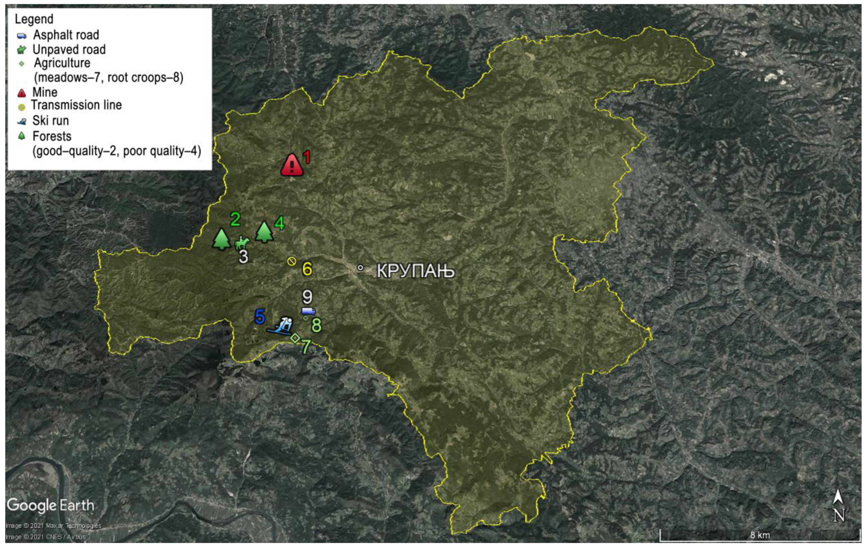
| Experimental Site | Coordinate (N) | Coordinate (E) |
|---|---|---|
| Good-quality forests | 44°22′26.20″ | 19°17′14.02″ |
| Poor-quality forests | 44°22′37.71″ | 19°17′14.02″ |
| Agriculture—root crops | 44°20′43.40″ | 19°20′15.17″ |
| Agriculture—pastures | 44°20′11.70″ | 19°19′57.15″ |
| Mining—tailings pond | 44°24′27.22″ | 19°19′26.80″ |
| Dirt Roads | 44°22′28.03″ | 19°17′56.25″ |
| Hard-surfaced roads | 44°20′46.39″ | 19°20′20.01″ |
| Transmission line | 44°22′8.77″ | 19°19′39.25″ |
| Ski run | 44°22′26.20″ | 19°17′14.02″ |
| Erosion Category | Severity of Erosion Processes in the Basin | Erosion Coefficient Z | Mean Value of Erosion Coefficient Z |
|---|---|---|---|
| I | Excessive erosion | ≥1.01 | 1.25 |
| II | Heavy erosion | 0.71–1.00 | 0.85 |
| III | Medium erosion | 0.41–0.70 | 0.55 |
| IV | Slight erosion | 0.2–0.40 | 0.30 |
| V | Very slight erosion | ≤0.19 | 0.1 |
| Experimental Surfaces | Y | X·α | φ |
|---|---|---|---|
| Good-quality forests | 1 | 0.05 | 0.1 |
| Poor-quality forests | 1 | 0.6 | 0.7 |
| Agriculture—root crops | 1 | 0.7 | 0.3 |
| Agriculture—pastures | 1 | 0.4 | 0.2 |
| Mining—tailings pond | 1 | 1 | 1 |
| Dirt roads | 1 | 1 | 0.9 |
| Transmission lines | 1 | 0.4 | 0.3 |
| Ski run | 1 | 0.2 | 0.1 |
| Land Use | Z | Erosion Category |
|---|---|---|
| Good-quality forests | 0.03 | V |
| Poor-quality forests | 0.82 | II |
| Agriculture—root crops | 0.57 | III |
| Agriculture—pastures | 0.22 | IV |
| Mining—tailings pond | 1.43 | I |
| Dirt roads | 1.25 | I |
| Transmission lines | 0.37 | IV |
| Ski run | 0.21 | IV |
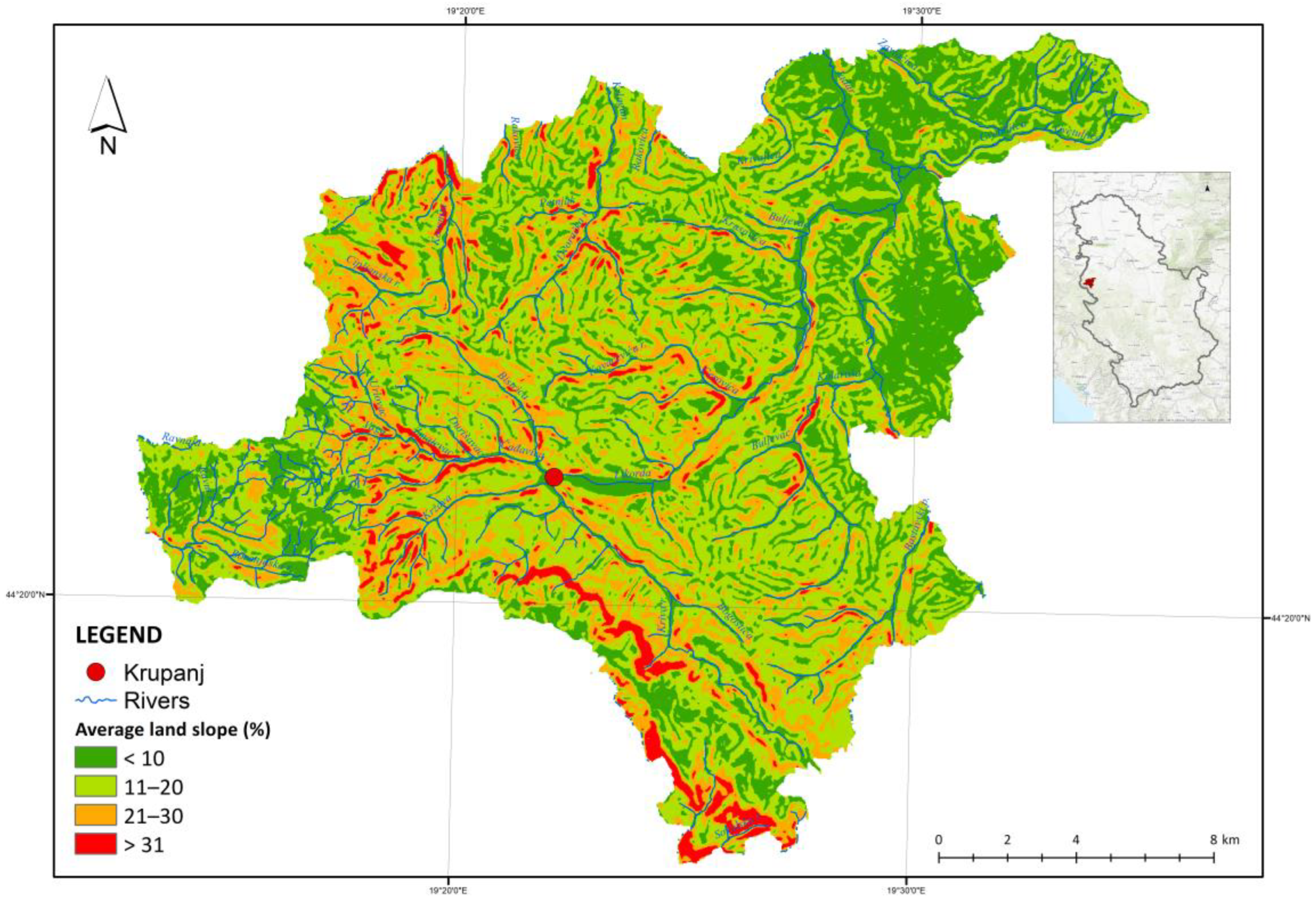
| Experimental Surfaces | Experimental Surface Size [km2] | Total Surface Area [km2] | Average Experimental Surface Dip [%] | Average Total Surface Area Dip [%] |
|---|---|---|---|---|
| Good-quality forests | 0.01 | 68.683 | 20.45 | 12.83 |
| Poor-quality forests | 0.01 | 60.251 | 44.66 | 14.77 |
| Agriculture—root crops | 0.01 | 154.344 | 27.5 | 12.3 |
| Agriculture—pastures | 0.01 | 45.178 | 12.23 | 14.5 |
| Mining—tailings pond | 0.01 | 0.5 | 18.13 | 18.13 |
| Dirt roads | 0.01 | 2.49 | 12.43 | 12.41 |
| Transmission lines | 0.01 | 2.215 | 38.54 | 12.41 |
| Ski run | 0.01 | 0.2 | 6.62 | 6.62 |
| Experimental Surfaces | Experimental Surface Size [km2] | Total Surface Area [km2] | Sediment Production from the Experimental Surfaces | Sediment Production from All Surfaces |
|---|---|---|---|---|
| Good-quality forests | 0.01 | 68.683 | 0.17 | 1178.92 |
| Poor-quality forests | 0.01 | 60.251 | 24.57 | 148,056.22 |
| Agriculture—root crops | 0.01 | 154.344 | 14.48 | 223,515.89 |
| Agriculture—pastures | 0.01 | 45.178 | 3.14 | 15,338.45 |
| Mining—tailings pond | 0.01 | 0.5 | 56.24 | 2812.08 |
| Dirt roads | 0.01 | 2.49 | 46.31 | 11,531.10 |
| Transmission lines | 0.01 | 2.215 | 7.38 | 1635.64 |
Disclaimer/Publisher’s Note: The statements, opinions and data contained in all publications are solely those of the individual author(s) and contributor(s) and not of MDPI and/or the editor(s). MDPI and/or the editor(s) disclaim responsibility for any injury to people or property resulting from any ideas, methods, instructions or products referred to in the content. |
© 2023 by the authors. Licensee MDPI, Basel, Switzerland. This article is an open access article distributed under the terms and conditions of the Creative Commons Attribution (CC BY) license (https://creativecommons.org/licenses/by/4.0/).
Share and Cite
Bezbradica, L.; Josimović, B.; Milijić, S. Impact of Repurposing Forest Land on Erosion and Sediment Production—Case Study: Krupanj Municipality—Serbia. Forests 2023, 14, 1127. https://doi.org/10.3390/f14061127
Bezbradica L, Josimović B, Milijić S. Impact of Repurposing Forest Land on Erosion and Sediment Production—Case Study: Krupanj Municipality—Serbia. Forests. 2023; 14(6):1127. https://doi.org/10.3390/f14061127
Chicago/Turabian StyleBezbradica, Ljubiša, Boško Josimović, and Saša Milijić. 2023. "Impact of Repurposing Forest Land on Erosion and Sediment Production—Case Study: Krupanj Municipality—Serbia" Forests 14, no. 6: 1127. https://doi.org/10.3390/f14061127
APA StyleBezbradica, L., Josimović, B., & Milijić, S. (2023). Impact of Repurposing Forest Land on Erosion and Sediment Production—Case Study: Krupanj Municipality—Serbia. Forests, 14(6), 1127. https://doi.org/10.3390/f14061127