Article

Human-Induced Forest Fragmentation in Trabzon, Eastern Black Sea Region, Türkiye: A Case Study

by
Nur Diktaş Bulut
Department of Forest Enterprise and Economy, Eastern Black Sea Forestry Research Institute, Trabzon 61040, Türkiye
Forests 2023, 14(8), 1622; https://doi.org/10.3390/f14081622
Submission received: 15 June 2023 / Revised: 7 August 2023 / Accepted: 9 August 2023 / Published: 11 August 2023
(This article belongs to the Section Forest Ecology and Management)

Abstract

:
Due to the geographical structure of the Eastern Black Sea Region, agricultural activities are carried out in high-sloped areas that should ideally be used solely for forestry purposes. The region is characterized by an intricate intertwining of forested areas, agricultural fields, pasture lands, and residential areas, giving rise to a distinct and unique way of life. Within this framework, forest resources have been constantly under pressure and fragmented. This study, therefore, aims to determine the fragmentation status of forests, particularly due to various anthropogenic activities, such as agricultural activities, using the example of Trabzon Province in the Eastern Black Sea Region of Türkiye. Utilizing Geographic Information Systems (GIS), a comprehensive “forest fragmentation map” was meticulously crafted, drawing upon the land-use plans and cadastral maps specific to the study area. Spatial land metrics were calculated using patch analysis. In the study area, there is a total of 31,153.2 hectares of registered state forests. These forests consist of 423 separate and independent fragments. The average forest fragment size in the area is 73.6 hectares. The smallest fragment measures 0.01 hectares (100 square meters), while the largest one covers an area of 18,002 hectares. The area-weighted average figure index of the forest fragments is 9.4. This study quantified fragmented forests, providing evidence of forest fragmentation due to various anthropogenic activities, primarily agricultural activities. This study also proposed an integrated planning approach for the management of fragmented forests.

1. Introduction

The pressures on natural resources are increasing day by day due to rapid population growth and the impact of industrialization worldwide. The pressures in question do extensively affect forest resources. In order to mitigate the aforementioned impact and establish requisite preventive measures, it is imperative to provide an accurate representation of the prevailing condition of forest resources. Throughout the international forestry process, which was ignited with the UN Summit held in RIO in 1992, a total of nine regional processes were initiated around the world in order to implement hundreds of decisions taken in relation to forests. Türkiye is a participant in the Pan-European and Near East Forestry processes. The first task to complete in the regional process is to define sustainable forest management in compliance with the regional conditions and to identify the criteria and indicators of sustainable forest management at the regional level [1]. Türkiye has adopted the Declaration of Rio, Agenda 21, Forestry Principles, Convention on Biological Diversity, the Fight against Desertification, and the Framework Convention on Climate Change. Türkiye has also signed a total of 19 decisions taken in the “Ministerial Conference on the Protection of Forests in Europe” that led the Pan-European Forest Process and accepted all the specifications designated throughout the process. Türkiye has 22.34 million ha of forestland. In total, 99.9% of Turkish forests are owned by the State. The General Directorate of Forestry (GDF) is established as a corporate body, responsible for almost all sustainable forest management activities in Türkiye [2]. The GDF manages and operates the forest resources through 28 Regional Forest Management Directorates founded as provincial organizations and a total of 245 State Forest Enterprises operating under the regional directorates. In 1999, GDF adopted the Sustainable Forest Management National Criteria and Indicators (SFM C&I) set, which comprises 6 criteria and 28 indicators. SFM criteria have been monitored by State Forest Enterprises since 2000 [3]. One of the indicators that are monitored within this scope is Criterion 2: Biological Diversity; Indicator 1: Forest Fragmentation [1].
The notion of “fragmentation” has been defined in several different ways in the literature. While Deniz et al. [4] define fragmentation as the process of the transformation of open and natural areas into smaller and isolated units, Goparaju [5] indicates that forest fragmentation is the process that is the outcome of landscape changes, and large forest systems are divided into smaller, geometrical and more complex forest portions during the process. According to Coşkun Hepcan [6], fragmentation generally takes place as a result of human impact, especially in endeavors of opening spaces suitable for agriculture, housing, and constructing transportation networks. Snyder [7] highlights that forest fragmentation is the division of large, contiguous, forested areas into smaller chunks of forest, typically separated by roads, agriculture, service corridors, subdivisions, or other human development. Considering these arguments, it can be stated that fragmentation has two main focal points: it occurs over a specific period and primarily stems from human activities.
Landscape fragmentation and habitat loss are significant threats to the conservation of biological diversity [8]. The most outstanding threats against wild animals include shrinking habitats, which are limited by artificial barrages, and completely vanishing life spaces. This causes permanent impacts on the number and diversity of species, the interaction and relation between these species, and the combined environment created by all the species. Actually, the fragmentation of habitats will be among the most important problems of the next generation. Like in Türkiye, forest fragmentation is an important factor in the loss of biological diversity in the entire of Europe. According to the European Environment Agency (EEA), the development of human infrastructure, land-use change, excessive forest harvesting, and forest fires in Europe has resulted in a landscape of fragmented forests [9]. Thus, forest fragmentation caused by changes in human land-use activities is a primary concern for sustainability [10].
The main objective of this study is to assess the extent of forest fragmentation caused by local land utilization, using the State Forest Enterprise of Trabzon (SFET) as a case study, and to establish a database for monitoring the criteria and indicators of sustainable forest management. With this study, I aim to reveal the spatial distribution and intensity of the forest fragments in the SFET, Türkiye, the variance of their sizes, and the functions of these fragments in the pre-determined forest management plans, creating a database and drawing attention to these characteristics in future planning. This study was conducted in the areas that are registered as state forests in the cadastral surveys conducted within the broader borders of the State Forest Enterprise of Trabzon located in the Eastern Black Sea Region.

2. Materials and Methods

Study Area: The State Forest Enterprise of Trabzon is situated in the northeastern region of Türkiye, covering a land area of 135,128.9 hectares (Figure 1). It encompasses both a coastal section and mountainous basins.
The elevation of the State Forest Enterprise of Trabzon ranges from sea level (0 m) to 2342 m. In addition to the provincial center, it includes the districts of Akçaabat, Çarşıbaşı, Düzköy, Ortahisar, Şalpazarı, Tonya, and Vakfıkebir. The climate in the region is warm and rainy during summer, while winter is characterized by heavy rainfall and cool temperatures. The average lowest temperature in the area is around 10–12 °C, and the average highest temperature ranges from 20 to 22.5 °C. Agriculture and animal husbandry are the primary sources of income for residents in rural areas, with forest labor being significant, particularly in mountainous regions. Hazelnut farming is the most economically profitable agricultural activity. The unemployment rate in the region stands at 7.4% [11]. The study area is 135,128.9 hectares. The actual forest area in the administrative scope of SFET is 58,595.3 ha. The area registered as the state forest is made up of 31,153.2 ha. Of the state forests, 48,168 hectares are productive forests, and 10,427.3 hectares are degraded forest areas. The remaining 74,648.2 hectares are allocated for other land uses, such as agriculture, grassland, and residential areas. Due to the ongoing forest cadastral surveys, the forest management plans were developed based on the existing forest presence. The distribution of tree species in the study area is as follows: 16% alder, 13% spruce, 5% beech, 5% other broad-leaved trees (such as oak and chestnut), 35% mixed broad-leaved and coniferous trees, 24% mixed coniferous and broad-leaved trees, and 2% other coniferous species [12].
Geometric Correction of Data: To analyze the spatial distribution and fragmentation status of forest fragments in the study area, a comprehensive area sampling approach was employed using Geographic Information System (GIS) techniques. Stand-type maps obtained from forest management plans were incorporated into the analysis at a scale of 1/25,000. Forest parcels in *NCZ file format, along with the administrative boundaries of the Special Forest Ecosystems Directorate (SFET), were digitally integrated as separate layers to create a positional database for forest fragmentation assessment. The forest parcels in *NCZ file format underwent necessary transformations using the UTM projection (WGS 84 data) and were then imported into ArcMap v.10.2 software for further analysis.
Forest Fragmentation Map and Spatial Land Metrics: The individual forest fragments were merged and transformed into a single-layer representation. A coverage process was conducted to separate the merged forest fragments. Forest fragments were assigned a value of “1”, while other land uses, such as pasture, settlements, agriculture, etc., were assigned a value of “2”. These assignments were added to the features table, preparing them for further analysis.
The spatial distribution of the forest patches within the landscape structure was classified and represented on the map using different colors to depict this classification. This process resulted in the creation of a Forest Fragmentation Map. Landscape metrics, in conjunction with Geographic Information Systems (GIS), were utilized for this analysis. The integration of landscape metrics and digital data using GIS technologies contributed to landscape planning studies, as well as sustainable planning and development [13]. In this study, spatial land metrics were employed to analyze forest fragmentation. Commonly used metrics to identify forest fragmentation include the number of fragments, average fragment size, minimum and maximum fragment sizes, and area-weighted average figure index. Table 1 shows the spatial land metrics used in this study. To calculate these relevant metrics, Patch Analyst was utilized within the GIS/ArcMap v.10.2 software.
Management Purpose of the Fragmented Forests Map and EBM Map: In order to determine the spatial distribution and area sizes of forest fragments where ecosystem-based management (EBM) plans were implemented for industrial timber production, an EBM Map was created using ArcMap v.10.2. This map was then overlaid with the forest fragmentation map to examine the relationship between EBM areas and fragmented forests. Additionally, the allocation of functions (economic, ecological, socio-cultural, etc.) to the fragmented forests, as defined in the forest management plans, was analyzed. The management goals associated with these functions were incorporated into the features table, and a Management Purpose of the Fragmented Forests Map was generated using a classification method with a suitable color palette.

3. Results

3.1. Forest Fragmentation and Spatial Land Metrics

The results of spatial land metrics can be seen in Table 2. The analyzed forest fragments are the very forests that are registered as state forests in accordance with the forest cadastral survey of the State Forest Enterprise of Trabzon.
The examination of Table 2 shows that State Forest Enterprise of Trabzon manages 423 separate forest fragments, the largest one covering an area of 18,002 ha and the smallest one covering only 100 m2, registered as per the forest cadastral survey, and 504 fragments are currently used for “other” purposes (agriculture, pasture, settlement, etc.). The average forest fragment in the area is 73.6 ha, and the area-weighted average figure index of the forest fragments in the study area is 9.4.

3.2. Status of Forests Fragmentation

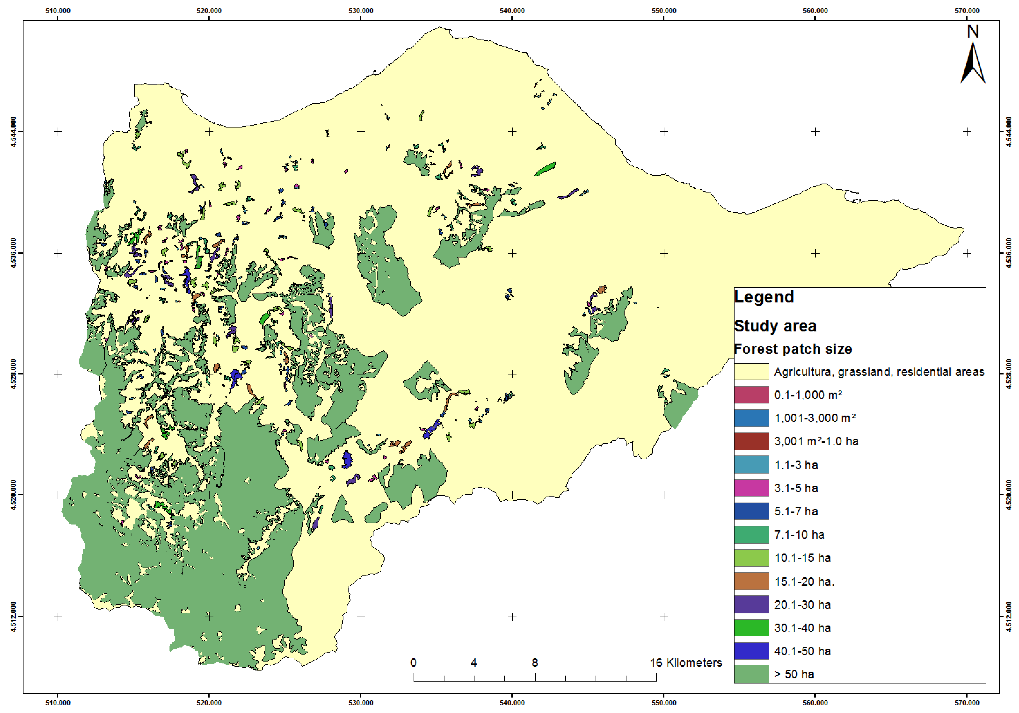
The Forest Fragmentation Map, which indicates the status of forest fragmentation within the administrative borders of SFET is presented in Figure 2. Digital representations of the spatial distribution of the forest areas registered per the forest cadastral survey were produced using ArcMap v.10.2 software and presented in Table 3.
In order to see the spatial distribution of the forest fragments in Table 3, the fragments were classified according to area size, and cumulative and rational distributions were calculated accordingly.
Classification monitored in accordance with “Criterion 2: Biological Diversity; Indicator 1: Forest Fragmentation”, which is included in the sustainable forest management criteria and indicators in revealing the status of forest fragmentation, is presented in Table 4.
Forest fragments smaller than 10 ha constitute 76% of all the fragments in the study area; yet, while their number is 320 in total, they occupy only 3% of the entire study area. The total area of the fragments ranging between 10 and 99 ha is 2275.2 ha, and it constitutes 7% of the total forest area. While the number of fragments larger than 99 ha is 21, they make up 90% of the total forests.

3.3. Management Plan Data of Fragmented Forests and Implementation Results

3.3.1. EBM Map

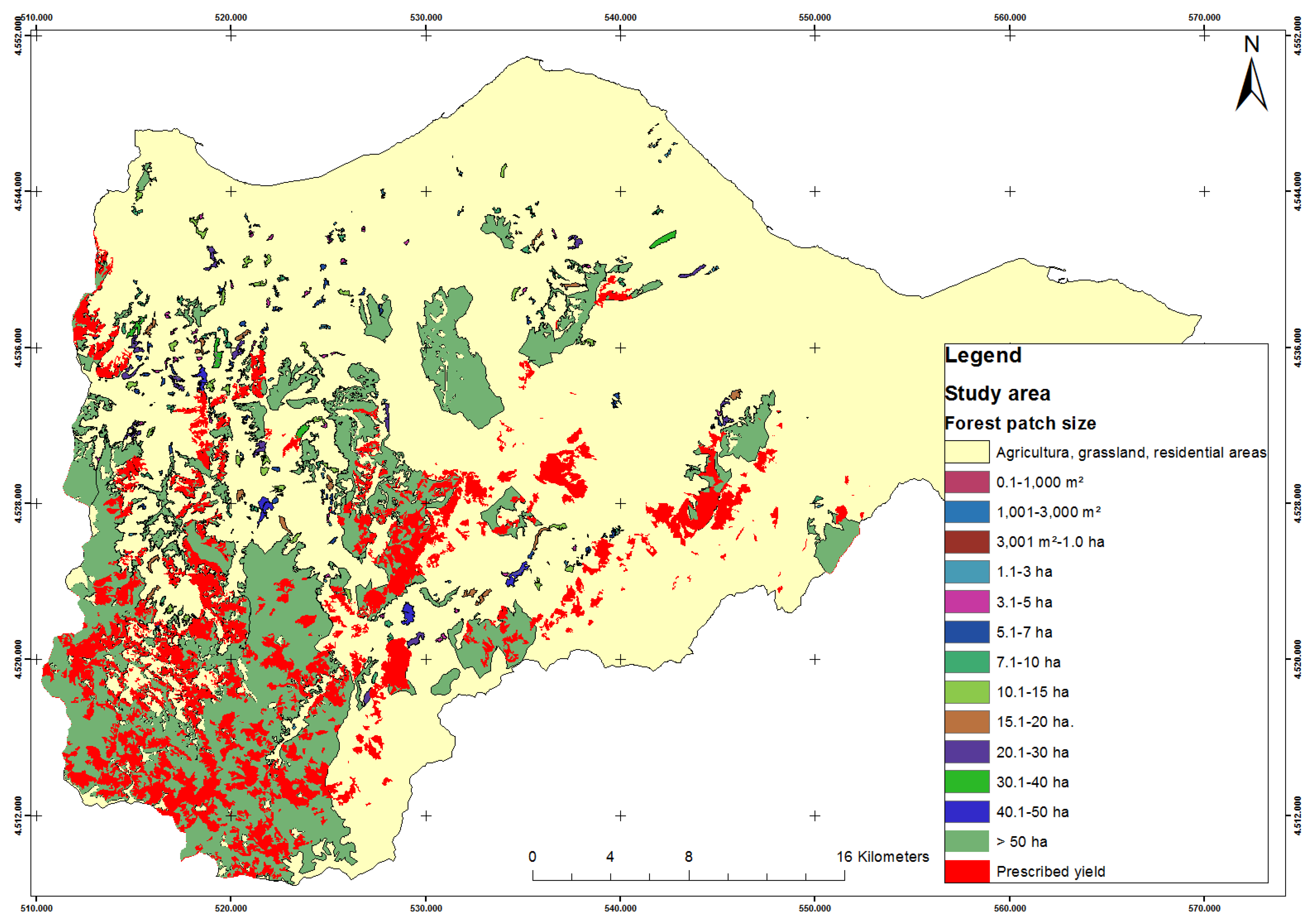
Forest management plans of State Forest Enterprise of Trabzon cover the period between 2007 and 2017, and in this current study, we determined the spatial status and area sizes of the forest fragments where ecosystem-based management (EBM) plans were made for industrial timber production in the scope of forest management plans. To do this, queries were run in ArcMap v.10.2 software, and consequently, the “planned EBM Map” was generated. By superposing the planned EBM map with the forest fragmentation map, the map presented in Figure 3 was produced.
Through the analysis carried out on the EBM map, the EBM attributed area in the forest management plans of State Forest Enterprise of Trabzon was calculated to be 14,644 ha. The EBM-attributed forest area comprises 25% of the total forests in the study area. The average size of the EBM-attributed forest area is 7.7 ha.
According to the forest management plans of State Forest Enterprise of Trabzon, the planned annual average EBM equals 22,275 m3 (16,737 m3 for maintenance EBM and 5538 m3 for regeneration EBM). While the rate of realization of maintenance endeavors in the last ten years, according to forest management plans, has been 28%, the rate of regeneration realizations has been 126%. In other words, 52% of the planned forestry implementations in the fragmented forests of State Forest Enterprise of Trabzon could be realized (Table 5).

3.3.2. Forest Functions and Management Purpose Map

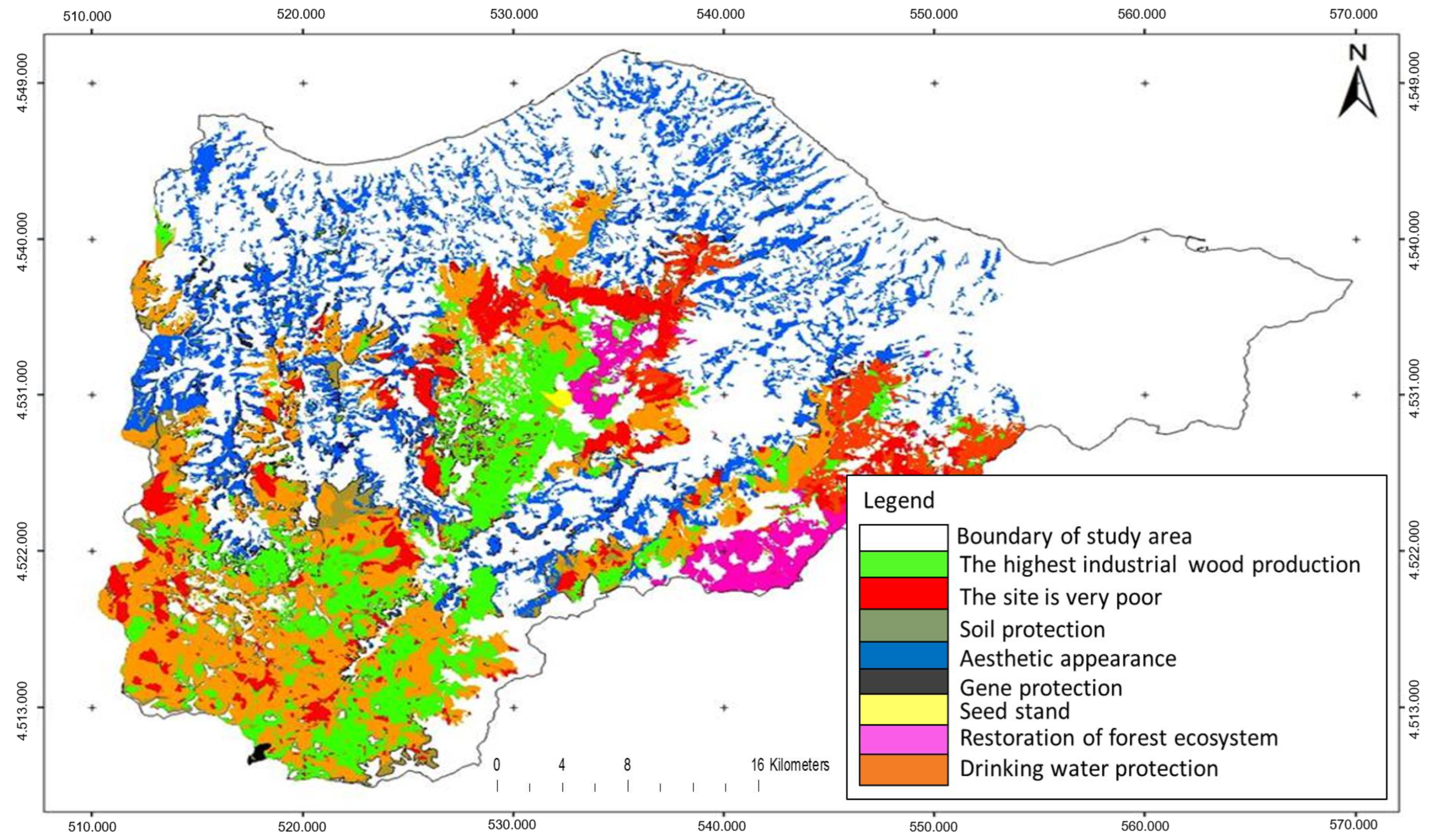
In this phase, an attempt was made to determine which forest functions forest planners evaluate the fragmented (relatively small) forests in. A management purpose map of the fragmented forests produced out of forest management plans was superposed with the fragmentation map (Figure 4).
The fragments in the study area were classified by forest planners into three forest functions: economic, ecological, and social and cultural. The management purposes of the fragments, on the other hand, were assessed per the following criteria: maximum industrial timber yield, gene protection, improving forest ecosystem, unfavorable areas for cultivation, seed stands, soil conservation, drinking water conservation, and aesthetic appearance.
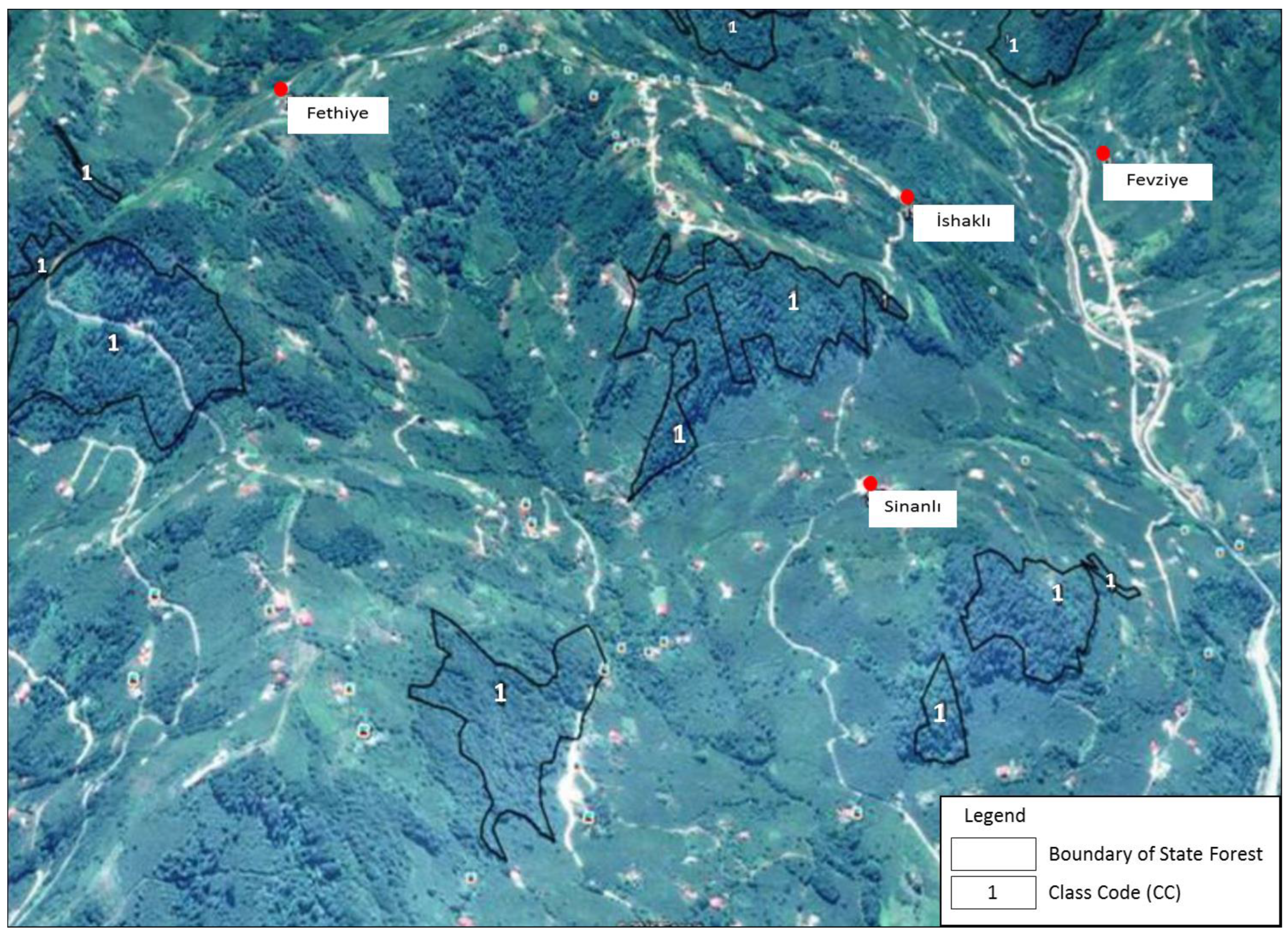
As cadastral bases were not used during the planning phase of the fragmented forests and forest cadastral surveys have yet to be completed, woodlands that are not included in the state forests were also taken into account while drafting plans. In order to examine this, a forest fragmentation map was opened in the Google Earth program, and forests located especially in village settlements and along the coastline were scrutinized. It was found that there exist forests and other forms of woodlands aside from the ones registered as state forests (Figure 4 and Figure 5).

4. Discussion and Conclusions

The importance of land cover information stems from its capacity to function as a reliable proxy for assessing environmental conditions within a given landscape, taking into account the likelihood of alterations in land composition and arrangement. Hence, there is a pressing need to acquire a thorough understanding of the spatial and temporal attributes associated with these environmental factors, as it empowers decision makers to effectively address the fundamental causes of environmental issues and proficiently manage their subsequent ramifications [16]. In order to uphold ecological equilibrium and promote sustainable utilization of resources, an all-encompassing comprehension of forest fragmentation is indispensable [17].
Numerous studies have consistently demonstrated that human attitude plays a pivotal role in driving alterations in land use patterns, encompassing local, regional, and global scales [18]. This study quantified fragmented forests, providing compelling evidence of forest fragmentation due to various anthropogenic impacts, primarily agricultural activities. It also furnished crucial information for monitoring and evaluating fragmented forests within the framework of sustainable forest management criteria and indicators. In this study, unlike the literature, the status of privately owned forest fragments that have forest quality but are not classified as state forests and are not included in forestry management plans was also examined using cadastral data. Revealing the spatial status of forested areas that have forest characteristics is crucial for the sustainable use of natural resources. The extensive size of the Eastern Black Sea Region and the density of its dataset posed limitations on sampling and deriving fragmentation maps over large areas. Hence, the choice to focus solely on Trabzon Province as the study area imposes limitations on the generalizability of the findings in this research. Furthermore, due to the difficulty in accessing numerical data concerning land use types such as agricultural land, pasture, and settlement areas outside of forests, the land classification in this study was assessed in two categories: forests and other areas.
Due to its peculiar geographical characteristics, the Eastern Black Sea Region of Turkey has predominantly exhibited a dispersed settlement pattern, with most of the area previously covered by forests [19]. In this particular settlement pattern, the need for more agricultural land increased in parallel with the growing population, and in time, forests were destroyed to significant degrees [20,21,22]. Village houses are generally located far away from one another, and each one of them is independent of the others. Forests were transformed into small portions scattered around the settlements and agricultural lands as a result of a growing population and the dispersed settlement pattern. Therefore, they started to fail in their ecological functions. Agricultural activities are performed in the highly sloping lands of the region, which actually must remain as forestlands due to the general geographical features. Due to the fact that cadastral surveys of forests could not be completed for many years and the geography (topography) of the region is not suitable for agriculture, agricultural lands have been expanding far into the forest areas. Forests, agricultural lands, pastures, and settlements are now intertwined in the region, creating a lifestyle special to the region. The forest resources have always been under pressure in this pattern and, consequently, became fragmented [19].
The study area contains 31,153.2 ha of registered state forest area in total. These forests are composed of 423 independent fragments. As a result of this, it can be inferred that the forests of the study area do not have ecological integrity. The average forest fragment in the area is 73.6 ha. The smallest fragment measures 0.01 ha (100 m2), while the largest one covers an area of 18,002 ha. The area-weighted average figure index of the forest fragments is 9.4. When all the fragments are circular, the figure index is equal to “1”, and when the fragments are irregular, the figure index value diverts positively from “1” [14,15]. Therefore, it can be uttered that the forest fragments in the study area have a wide distribution pattern.
Even though the number of forest fragments in the study area is high, the ratio of these fragments in the general forest area is relatively small. The number of fragments smaller than 50 ha is 389, and the area ratio of these fragments in the total forest area is 6.93%. Similarly, while the number of forest fragments smaller than 10 ha is 320 (76%), the combined area of these 320 fragments is equal to 822 ha (3%). Sarı and Karahalil [23] revealed in their study, which applies to Akçaabat, that numerous natural ecosystems were fragmented over the course of time, and the number of forest fragments has been rapidly increasing due to these problems, which increased landscape fragmentation and made forests more susceptible to disturbances. A similar study conducted by Zengin et al. [24] in the West Black Sea Region portrays that areas do change thanks to human utilization, and forest stands were divided into small patches in the period between 1970 and 2010 and caused interesting changes in the structure of the landscape.
It was found in this study that land usage of local people for agricultural purposes because of the sloping/mountainous terrain and the lack of suitable farmlands played a crucial role in forest fragmentation. In parallel with our findings, Lim and Douglas [25] indicate that the geographical characteristics of an area (topography, etc.) are one of the key factors that determine the pattern of land utilization. Similarly, Girvetz et al. [26] stress that urban development, transportation infrastructure, and landscape fragmentation due to agricultural activities threaten environmental integrity. Butler et al. [27], on the other hand, indicate that “natural, human land-cover, and human land-use processes” contribute to the forest fragmentation in western Oregon and western Washington. It was revealed in the study conducted by Tağıl [28] in the surroundings of Balıkesir Plain, Türkiye, that habitats are changed by human activities, and this change turned bushland into pastures, which is followed by completely barren areas. Jain et al. [29] indicate that villages, roads, and pilgrimage sites increase the rate of forest degradation and fragmentation. In other studies, the expansion of agricultural lands is perceived as one of the major causes of forest fragmentation [30,31,32].
Small forest fragments in the study area are scattered around agricultural lands, pastures, settlements, and along the coastline as small spots. The number of forest fragments decreases while the size of each fragment grows as we draw away from the settlements and the shore. Karahalil et al. [33] emphasize the dispersal of settlement areas towards favorable locations for human habitation, particularly along the coastline and towards the southern regions with higher elevation, proximate to the city center. In a different study conducted by Liu et al. [34] in Lincang City, situated within the Lancang River Valley, it was observed that habitat losses were more prevalent at lower altitudes, in close proximity to urban areas and the road network. Dewan et al. [35] found that sharp changes took place in the landscape composition and shape of Dhaka metropolitan, Bangladesh, and the landscape became heavily fragmented as a result of the rapid increase in built-up areas.
The dense population and large settlements along the coastline in the Eastern Black Sea Region have a history of about a hundred years. Despite the unique opportunities they provide for transportation, the coastal areas are known to have been unsuitable for settlement due to malaria epidemics. Therefore, this area was covered with dense forests. Once people managed to eradicate malaria in the area, settlements grew larger along the coastline, resulting in heavier damage to forests. Consequently, forests drew back to inner sections of the coastline in connection with population density and could only continue to exist away from the shores. The information revealed at the end of this current study was also discussed by several authors [20,36,37] in the 1950s. Illustrations of such circumstances can be observed across diverse geographical regions. Liu et al. [38] assert that the majority of China’s old-growth forests persist as small and isolated fragments in areas unsuitable for human utilization, resulting in the disappearance of numerous native species. These findings shed light on the factors contributing to forest fragmentation, which are intertwined with population movements and land utilization. Supporting these observations, Newmark [39] discovered that the forests of the Eastern Arc Mountains underwent fragmentation over time due to population growth, leading to significant losses. Bogaert et al. [40], in their study conducted in the Democratic Republic of Congo (Eastern Province) and North Benin, established that anthropogenic activities played a crucial role in landscape fragmentation, with the spatial distribution of forest cover being linked to population density and land use changes. In addition to studies that identified an increase in forest fragmentation due to human land use and population growth, there are also studies, such as Bayramoğlu and Kadıoğulları [41], Şen et al. [42], and Çakir et al. [43], that revealed an expansion of forest areas due to a decrease in rural population.
Fragmented forests were divided into three main forest functions in forest management plans: economic, ecologic, and social–cultural. It was seen that the fragments located especially along the coastline and around the settlement areas are allocated for aesthetic appearance purposes, and the forests with larger areas that are located away from the coastline are meant for such purposes as industrial utilization and soil protection. Similarly, it was determined that small forest fragments located around settlements, or intertwined with settlements, are spared for social–cultural functions due to social pressures.
Areas planned for industrial timber production comprise 25% of the forest areas. In other words, 75% of the state forests in the study area are allocated for purposes other than production. Around 52% of the planned production can be realized in the forests that are meant to be utilized for production. Authorized persons of State Forest Enterprise of Trabzon (manager, vice-managers, and forest sub-district directors) indicated in face-to-face interviews that planned forest maintenance works could not be fully achieved because of the topography of the study area, insufficiency of road networks and especially the social problems, and in the denseness and initial thinning activities, endeavors are hindered by such causes as lack of labor force, high unit costs and lack of demand for the produced forest assets.
The fact that the ownership data are not used in forest management plans in Türkiye causes significant problems [19,44]. Some problems deriving from unused cadastral bases in forest planning were identified in the current study, as well. That is, the Communiqué no 299 of the General Directorate of Forestry states: “Conformity of forest management plans and maps with cadastral data can only be maintained if the draft stand maps drawn by applicable units in accordance with cadastral data exist. In the cases where finalized cadastral borders cannot be marked on draft stands, conformity of forest management plans with cadastral borders cannot be maintained”. In this respect, cadastral-based stand drafts were not used in the preparation phases of forest management plans for the study area. As a result of this, forest administrators face problems in the implementation steps of forest management plan data and providence of inventory data of forest resources.
Forest areas that are registered as “state forests” in the study area do not correspond with forest areas that are recorded in the forest management plan; forest areas outnumber the former. The study conducted by Ün [45] in İstanbul, Türkiye, found that area divergence existed due to the fact that private forest areas are not stated in forest management plans, and this creates various problems in forestry endeavors. Several studies conducted in Türkiye stress that cadastral databases that are subject to private ownership must definitely be included in forest management plans [45,46,47]. Therefore, necessary legislative and technical measures should be taken in order to solve the problems deriving from unused cadastral bases in the planning phase of forest resources.
In the examination of the Google Earth map and fragmentation map to identify the current status of the forest fragments with borders that are defined with cadastral works, it was detected that there are many forests and woodlands apart from the fragments that are registered as state forests. The examination of the scenery that portrays a fragmented pattern in terms of private properties showed that these areas carry the characteristics of a forest, yet they are classified as privately owned non-forest lands in legal terms. It is estimated that the introduction of new laws and regulations relating to the woodlands that are located along the coastline, which look pretty much like a forest despite being privately owned properties, can contribute to sustainable forest management goals such as the protection and improvement of forests, expanding existing forests and ensuring rational utilization.
It is evident that the pressure exerted by humans on natural resources will continue in the present and future, just as it did in the past. Therefore, in terms of ensuring the sustainability of forest ecosystems, fragmented forests need to be subjected to an integrated planning approach that encompasses economic, ecological, and social considerations while also accommodating the ability of local communities to adapt.

Funding

Funding for this work was provided by the Republic of Türkiye Ministry of Agriculture and Forestry, General Directorate of Forestry, Eastern Black Sea Forestry Research Institute, through contract TZN-03.8206.

Data Availability Statement

Not applicable.

Acknowledgments

I would like to thank Uğur ER, Mehmet Ali SAYIN, Cantürk GÜMÜŞ, Vildane GERÇEK, Necati ÇOLAK, and Hüseyin AYAZ for their contributions to this study.

Conflicts of Interest

The author declares no conflict of interest.

References

  1. Anonymous. The Report of Sustainable Forest Management; General Directore of Forestry: Ankara, Türkiye, 2008.
  2. Anonymous. Forest Policy Note Turkey. Financing and Global Knowledge: Bringing the Best to Turkey and Sharing the Best of Turkey with the Word, Word Bank Group. 2017. Available online: http://documents.worldbank.org/curated/en/694751507885204989/pdf/12-10-2017-13-48-33-TurkeyForestPolicyNoteweb.pdf (accessed on 20 July 2022).
  3. Seven, Y. 2009. Soy K&G, General Directore of Forestry. Available online: http//www.ogm.gov.tr/ekutuphane/.../Sunular/ANTALYA%20YUNUS%20SEVEN.pptx (accessed on 9 April 2022).
  4. Deniz, B.; Küçükerbaş, E.V.; Eşbah Tunçay, H. General Introduction to Landscape Ecology. Adnan Menderes Univ. Fac. Agric. J. Agric. Sci. 2006, 3, 5–18. [Google Scholar]
  5. Goparaju, L.N. Save Forests: Avoid Forest Fragmentation. 2011. Available online: https://thinktosustain.com/2011/06/save-forests-avoid-forest-fragmentation/ (accessed on 25 May 2023).
  6. Coşkun Hepcan, Ç. Identification and Planning of Ecological Networks as a Sustainabile Approach in Nature Conservation; the Case of Çeşme-Urla Peninsula. Ph.D. Thesis, Institute of Science, Ege University, İzmir, Türkiye, 2008. Available online: https://tez.yok.gov.tr/UlusalTezMerkezi/tezDetay.jsp?id=uTNkvayJJQZBTQGPFML-hw&no=vPHj-akrEWS8eoQx3xGpvQ (accessed on 10 September 2022).
  7. Synder, M. What Is Forest Fragmentation and Why Is It a Problem? 2014. Available online: https://northernwoodlands.org/articles/article/forest-fragmentation (accessed on 10 June 2023).
  8. Williams, J.C.; Snyder, S.A. Restoring habitat corridors in fragmented landscapes using optimization and percolation models. Environ. Model. Assess. 2005, 10, 239–250. [Google Scholar] [CrossRef]
  9. Anonymous. The European Environment, State and Outlook 2015. European Briefings, Forests, European Environment Agency. 2015. Available online: https://www.eea.europa.eu/downloads/5e8077f693a943eaaf614f296ab92a94/1479205837/forests.pdf (accessed on 10 September 2022).
  10. Abdullah, S.A.; Nakagoshi, N. Forest fragmentation and its correlation to human land use change in the state of Selangor, peninsular Malaysia. For. Ecol. Manag. 2007, 241, 39–48. [Google Scholar] [CrossRef]
  11. Anonymous. 2015-23. Trabzon Provincial Plan 2015–2023; Republic of Türkiye Governorship of Trabzon: Trabzon, Türkiye, 2015.
  12. Anonymous. State Forest Enterprise of Trabzon Activity Report 2018; Ministry of Agriculture and Forestry, General Directorate of Forestry, State Forest Enterprise of Trabzon: Trabzon, Türkiye, 2018.
  13. Teh, M.Z.; Ghani, I.; Abdullah, M. Development of Landscape Structure Index as Basis Indicator for Landscape Quality and Character: A Review. International Conference on Livable Cities. Int. Con. on Livable Cities, University Sains Malaysia, Penang, 2015. Available online: https://www.academia.edu/19526954/DEVELOPMENT_OF_LANDSCAPE_STRUCTURE_INDEX_AS_BASIS_INDICATOR_FOR_LANDSCAPE_QUALITY_AND_CHARACTER_A_REVIEW (accessed on 12 June 2022).
  14. McGarigal, K.; Marks, B.J. FRAGSTATS: Spatial Pattern Analysis Program for Quantifying Landscape Structure. USDA Forest Service General Technical Report PNW-351, Corvallis. 1995. Available online: https://www.fs.usda.gov/pnw/pubs/pnw_gtr351.pdf (accessed on 25 June 2022).
  15. Şentürk, Ö. Determination of The Changes Occurred in the Last Forty Years in the Spatial Structure of Brutian Pine Forests Located in Aşağıgökdere Forest District in Eğirdir-Isparta. Master’s Thesis, Institute of Science, Süleyman Demirel University, Isparta, Türkiye, 2008. Available online: https://acikbilim.yok.gov.tr/bitstream/handle/20.500.12812/286814/yokAcikBilim_328480.pdf?sequence=-1&isAllowed=y (accessed on 6 February 2022).
  16. Alphan, H. Analysis of landscape changes as an indicator for environmental monitoring. Environ. Monit. Assess. 2016, 189, 24. [Google Scholar] [CrossRef]
  17. Zhang, L.; Liu, Y.; Wei, X. Forest Fragmentation and Driving Forces in Yingkou, Northeastern China. Sustainability 2017, 9, 374. [Google Scholar] [CrossRef] [Green Version]
  18. Wyman, M.S.; Stein, T.V. Modeling social and land-use/land-cover change data to assess drivers of smallholder deforestation in Belize. Appl. Geogr. 2010, 30, 329–342. [Google Scholar] [CrossRef]
  19. Bulut, N.D.; Gümüş, C.; Er, U.; Sayin, M.A.; Gerçek, V.; Ayaz, H.; Çolak, N. Evaluation of management problems of fragmented forests: A case study on Trabzon Forest District Directorate. Turk. J. For. Res. 2019, 6, 177–191. [Google Scholar] [CrossRef] [Green Version]
  20. İnal, S. Forestry and forestry issues in Türkiye. Orman Ve Av 1957, 1, 12–20. [Google Scholar]
  21. İlkmen, Ş.N. The Problem of Statism in Forest Management and the Main Cases of Our Forestry Policy. In Panel of Scientific Opinions on Various Aspects of Our Forest Case; Turkey Foresters Association: Ankara, Türkiye, 1951; pp. 11–28. [Google Scholar]
  22. Gümüş, C. A historical review on the effects of settlement problems on Turkish Forestry. In Proceedings of the International New Horizons in Forestry, Isparta, Türkiye, 18–20 October 2017; University of Süleyman Demirel: Isparta, Türkiye, 2017; p. 70. [Google Scholar]
  23. Sari, B.; Karahalil, U. Land cover dynamics in Akçaabat planning unit between 1984 and 2008. In Proceedings of the 1st International Conference on Sea and Coastal Development in the Frame of Sustainability, Trabzon, Türkiye, 18–20 September 2015; Karadeniz Technical University: Trabzon, Türkiye, 2015; pp. 750–758. [Google Scholar]
  24. Zengin, H.; Değermenci, A.S.; Bettinger, P. Analysis of temporal changes in land cover and landscape metrics of a managed forest in the west Black Sea region of northern Turkey: 1970–2010. J. For. Res. 2017, 29, 139–150. [Google Scholar] [CrossRef]
  25. Lim, J.N.W.; Douglas, I. Land management policy and practice in a steepland agricultural area: A Malaysian ex-ample. Land Degrad. Dev. 2000, 11, 51–61. [Google Scholar] [CrossRef]
  26. Girvetz, E.H.; Thorne, J.H.; Berry, A.M.; Jaeger, J.A. Integration of landscape fragmentation analysis into regional planning: A statewide multi-scale case study from California, USA. Landsc. Urban Plan. 2008, 86, 205–218. [Google Scholar] [CrossRef]
  27. Butler, B.J.; Swenson, J.J.; Alig, R.J. Forest fragmentation in the Pacific Northwest: Quantification and correlations. For. Ecol. Manag. 2004, 189, 363–373. [Google Scholar] [CrossRef]
  28. Tağıl, Ş. Change of habitat fragmentation and quality in the Balikesir plain and its surroundings with landscape pattern metrics (1975–2000). Ekoloji 2006, 15, 24–36. [Google Scholar]
  29. Jain, P.; Ahmed, R.; Sajjad, H. Assessing and monitoring forest health using a forest fragmentation approach in Sariska Tiger Reserve, India. Nor. Geogr. Tidsskr. Nor. J. Geogr. 2016, 70, 306–315. [Google Scholar] [CrossRef]
  30. Lepers, E.; Lambin, E.F.; Janetos, A.C.; DeFries, R.S.; Achard, F.; Ramankutty, N.; Scholes, R.J. A Synthesis of Information on Rapid Land-cover Change for the Period 1981–2000. BioScience 2005, 55, 115–124. [Google Scholar] [CrossRef]
  31. Geist, H.J.; Lambin, E.F. Proximate Causes and Underlying Driving Forces of Tropical Deforestation: Tropical forests are disappearing as the result of many pressures, both local and regional, acting in various combinations in different geographical locations. Bioscience 2002, 52, 143–150. [Google Scholar] [CrossRef] [Green Version]
  32. McConnell, W.J.; Sweeney, S.P.; Mulley, B. Physical and social access to land: Spatio-temporal patterns of agricultural expansion in Madagascar. Agric. Ecosyst. Environ. 2004, 101, 171–184. [Google Scholar] [CrossRef]
  33. Karahalil, U.; Çil, B.; Toylan, Y. The expansion of settlement and agriculture areas towards to coastal zone and high lands between 1970 and 2009 in Yomra district. In Proceedings of the 1st International Conference on Sea and Coastal Development in the Frame of Sustainability, Trabzon, Türkiye, 18–20 September 2015; Karadeniz Technical University: Trabzon, Türkiye, 2015; pp. 731–741. [Google Scholar]
  34. Liu, S.; Dong, Y.; Deng, L.; Liu, Q.; Zhao, H.; Dong, S. Forest fragmentation and landscape connectivity change associated with road network extension and city expansion: A case study in the Lancang River Valley. Ecol. Indic. 2013, 36, 160–168. [Google Scholar] [CrossRef]
  35. Dewan, A.M.; Yamaguchi, Y.; Rahman, Z. Dynamics of land use/cover changes and the analysis of landscape fragmentation in Dhaka Metropolitan, Bangladesh. GeoJournal 2010, 77, 315–330. [Google Scholar] [CrossRef]
  36. Saatçioğlu, F. The Struggle between Agriculture and Forestry in Our Country and the Necessity of Iinternal Settlement. In Panel of Scientific Opinions on Various Aspects of Our Forest Case; Turkey Foresters Association: Ankara, Türkiye, 1951; pp. 34–45. [Google Scholar]
  37. Irmak, A. We should make rational use of forest and agricultural lands. In Panel of Scientific Opinions on Various Aspects of Our Forest Case; Turkey Foresters Association: Ankara, Türkiye, 1951; pp. 46–48. [Google Scholar]
  38. Liu, J.; Coomes, D.A.; Gibson, L.; Hu, G.; Liu, J.; Luo, Y.; Wu, C.; Yu, M. Forest fragmentation in China and its effect on biodiversity. Biol. Rev. 2019, 94, 1636–1657. [Google Scholar] [CrossRef]
  39. Newmark, W.D. Forest Area, Fragmentation, and Loss in the Eastern Arc Mountains: Implications for the Conservation of Biological Diversity. J. East Afr. Nat. Hist. 1998, 87, 29–36. [Google Scholar] [CrossRef]
  40. Bogaert, J.; Barima, Y.S.S.; Iyongo, L.; Mongo, W.; Bamba, I.; Mama, A.; Toyi, M.; Lafortezza, R. Forest Fragmentation: Causes, Ecological Impacts and Implications for Landscape Management. In Landscape Ecology in Forest Management and Conservation, Challenges and Solutions for Global Change; Li, C., Lafortezza, R., Chen, J., Eds.; Springer: Berlin/Heidelberg, Germany, 2011; pp. 273–296. ISBN 978-3-642-12753-3. [Google Scholar]
  41. Bayramoğlu, M.M.; Kadıoğulları, A. Analysis of Land Use Change and Forestation in Response to Demographic Movement and Reduction of Forest Crime. Eurasia J. Math. Sci. Technol. Educ. 2017, 14, 225–238. [Google Scholar] [CrossRef] [PubMed]
  42. Sen, G.; Bayramoglu, M.M.; Toksoy, D. Spatiotemporal changes of land use patterns in high mountain areas of Northeast Turkey: A case study in Maçka. Environ. Monit. Assess. 2015, 187, 1–14. [Google Scholar] [CrossRef] [PubMed]
  43. Çakir, G.; Sivrikaya, F.; Keleş, S. Forest cover change and fragmentation using Landsat data in Maçka State Forest Enterprise in Turkey. Environ. Monit. Assess. 2007, 137, 51–66. [Google Scholar] [CrossRef]
  44. Çakır, G.; Güler, A.; Zengin, H.; Değermenci, A.S. Integration of cadaster information with forest management and planning. Düzce Univ. J. For. 2014, 10, 48–58. [Google Scholar]
  45. Çakır, G. Determination of Temporal Changes in Forest Resources of Istanbul Province with Remote Sensing and GBS. Master’s Thesis, Institute of Science, Karadeniz Technical University, Trabzon, Türkiye, 2006. [Google Scholar]
  46. Erdin, K. The Basic Base Map Problem in Forestry in Turkey and the Creation of a Computer-Aided Forest Information System. J. For. Fac. Istanb. Univ. B 1988, 38, 64–71. Available online: https://dergipark.org.tr/tr/download/article-file/175184 (accessed on 10 March 2021).
  47. Çakır, G. Producing draft forest stand type map using previous stand type maps and high resolution satellite images. Kastamonu Univ. J. For. Fac. 2012, 12, 278–284. [Google Scholar]
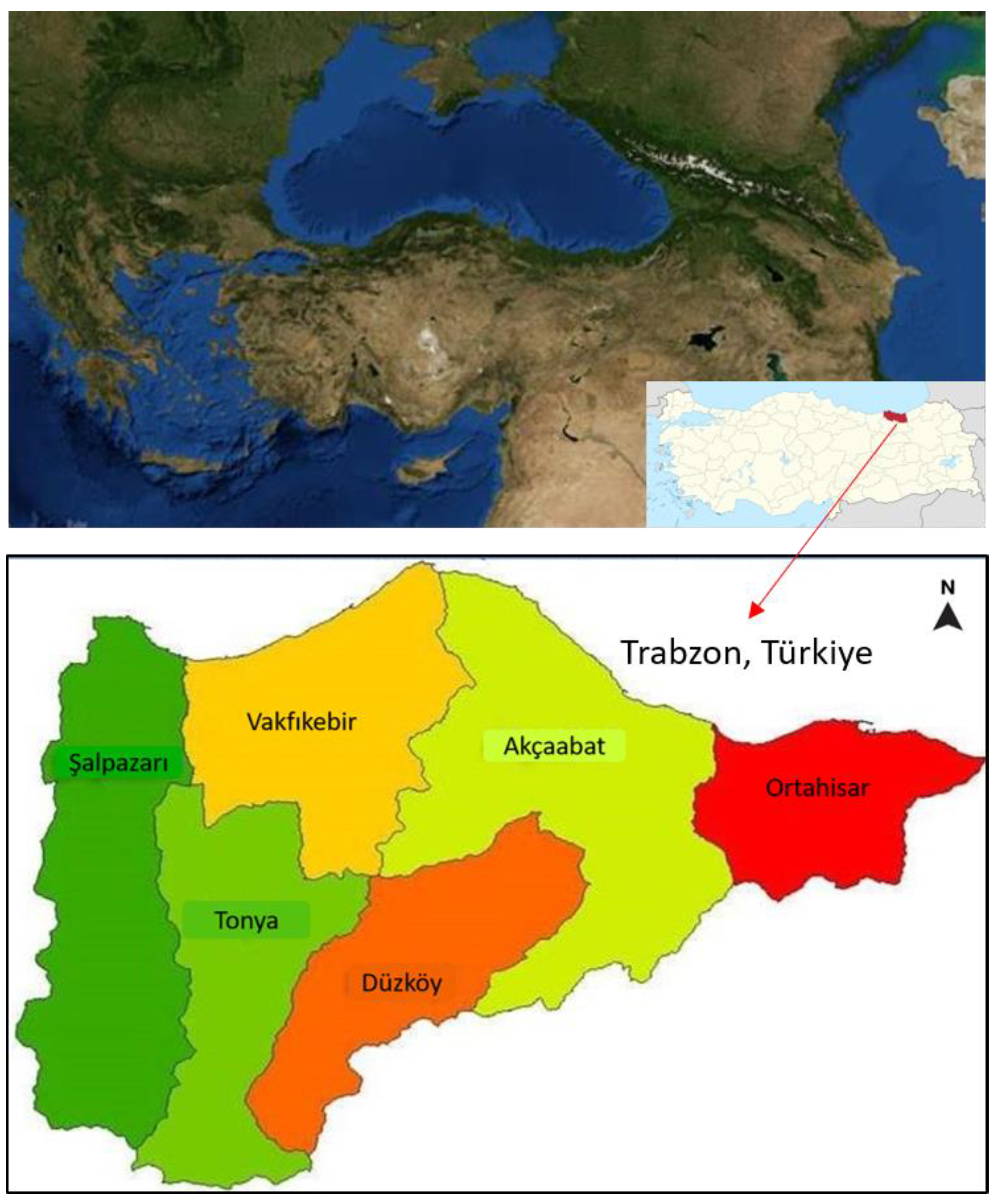
Figure 1. The geographic location of the study area [11].
Forests 14 01622 g001
Figure 2. Forest fragmentation map.
Forests 14 01622 g002
Figure 3. EBM map of fragmented forests.
Forests 14 01622 g003
Figure 4. Management purpose map of the fragmented forests.
Forests 14 01622 g004
Figure 5. State forest boundaries shown in black boundaries.
Forests 14 01622 g005
Table 1. Spatial land metrics used in this study.
The Spatial Land MetricsAbbreviationDefinition [14,15]
Number of PatchesNPNumber of Patches is the number of patches of the corresponding patch type (class).
Class AreaCAClass Area is the sum of the areas (m2) of all patches of the corresponding patch type, divided by 10,000 (to convert to hectares), which is the total class area.
Mean Patch SizeMPSMean Patch Size is the sum of the areas (m2) of all patches of the corresponding patch type, divided by the number of patches of the same type, divided by 10,000 (to convert to hectares).
Minimum Patch AreaMinPAMinimum Patch Area
Maximum Patch AreaMaxPAMaximum Patch Area
Mean Shape IndexMSIMean Shape Index is the sum of the patch perimeter (m) divided by the square root of patch area (m2) for each patch of the corresponding patch type, adjusted using a constant to adjust for a circular standard (vector) or square standard (raster), divided by the number of patches of the same type; in other words, MSI equals the average shape index (SHAPE) of patches of the corresponding patch type.
Area Weighted Mean Shape IndexAWMSIArea Weighted Mean Shape Index is the average shape index (SHAPE) of patches of the corresponding patch type, weighted by patch area so that larger patches weigh more than smaller patches.
Mean Perimeter–Area RatioMPARMean Perimeter–Area Ratio
Mean Patch EdgeMPEMean Patch Edge
Patch Size Coefficient of VariationPSCoVPatch Size Coefficient of Variation is the standard deviation in patch size (PSSD) divided by the mean patch size (MPS), multiplied by 100 (to convert to percent), which is the variability in patch size relative to the mean patch size.
Table 2. Calculation results for spatial land metrics using patch analyst.
Calculation LevelCalculation Parameters
ClassClass Code (CC)Patch Number (NP)CA (ha)MPS (ha)MinPA (ha)MaxPA (ha)MSIAWMSIMPARMPEPSCoV
Level
Forest (ha)142331,153.2073.60.0118,0021.99.462846211210.2
Other land (ha) (agriculture, pasture, settlement, etc.)2504103,975.70206.30.0013101,1371.813.7111541562181.5
Total landscape area (ha)135,128.90
Table 3. Spatial distribution of forest fragments.
Size of Forest Fragment (m2-ha)Number of FragmentsNumber of Fragments (%)Number of Fragments (Cumulative)Number of Fragments (%)Fragment Area (ha)Fragment Area (%)Fragment Area (ha) CumulativeFragment Area (%) Cumulative
0.1–1000 m23483481.80.011.80.01
1001–3000 m234868167.10.028.90.03
3001 m2–1.0 ha68161363238.50.1247.40.15
1.1–3.0751821150140.00.45187.40.60
3.1–5.0431025460171.90.55359.31.15
5.1–7.036929069215.80,69575.11.84
7.1–10.030732076246.70.79821.82.63
10.1–15.031735183376.31.211198.103.84
15.1–20.015436687254.00.821452.104.66
20.1–30.013337990308.80.991760.905.65
30.1–40.06138591210.00.671970.906.32
40.1–50.04138992188.90.612159.806.93
≥50.134842310028,993,493.0731,153.2100
Table 4. Forest fragmentation according to SFM C&I.
NoFragment Size RangeNumberNo of F./RateAreaArea of F./Rate
(%)(ha)(%)
1Forest Fragment ≤ 10 ha320768223
210 ha < Forest Fragment ≤ 99 ha82192275.27
3Forest Fragment > 99 ha21528,05690
Table 5. Realization rates for plan implementation.
ImplementationAverage Annual EBM (Planned) (m3)Average Realization
(m3)
Rate
(%)
Maintenance16,737465028
Regeneration55386978126
Total22,27511,62852
Disclaimer/Publisher’s Note: The statements, opinions and data contained in all publications are solely those of the individual author(s) and contributor(s) and not of MDPI and/or the editor(s). MDPI and/or the editor(s) disclaim responsibility for any injury to people or property resulting from any ideas, methods, instructions or products referred to in the content.