Article

The Role of Climate Change and Human Intervention in Shaping Vegetation Patterns in the Fen River Basin of China: Implications of the Grain for Green Program

1
Institute of Geographical Science, Taiyuan Normal University, Jinzhong 030619, China
2
Shanxi Key Laboratory for Surface Processes and Resource Ecological Security in Fen River Basin, Jinzhong 030619, China
3
Faculty of Electric Power Engineering, Kunming University of Science and Technology, Kunming 650500, China
4
State Key Laboratory of Simulation and Regulation of Water Cycle in River Basin, China Institute of Water Resources and Hydropower Research, Beijing 100038, China
*
Author to whom correspondence should be addressed.
Forests 2024, 15(10), 1733; https://doi.org/10.3390/f15101733
Submission received: 28 August 2024 / Revised: 22 September 2024 / Accepted: 28 September 2024 / Published: 29 September 2024
(This article belongs to the Special Issue Application of Remote Sensing in Vegetation Dynamic and Ecology)

Abstract

:
The Fen River Basin (FRB), an ecologically fragile region in China, exemplifies the intricate interplay between vegetation dynamics and both climatic and human-driven factors. This study leverages a 40-year (1982–2022) dataset, utilizing the kernel-based normalized difference vegetation index (kNDVI) alongside key climatic variables—rainfall (PRE), temperature (TMP), and solar radiation (SRAD)—to investigate vegetation variations and their drivers in the FRB, particularly in relation to the Grain for Green Program (GGP). Our analysis highlights significant greening across the FRB, with the kNDVI slope increasing by 0.0028 yr−1 and green-covered areas expanding by 92.8% over the study period. The GGP facilitated the greening process, resulting in a notable increase in the kNDVI slope from 0.0005 yr−1 to 0.0052 yr−1 and a marked expansion in the area of significant greening from 24.6% to 95.8%. Regional climate shifts, characterized by increased warming, heightened humidity, and a slight rise in SRAD, have further driven vegetation growth, contributing 75%, 58.7%, and 23.6% to vegetation dynamics, respectively. Notably, the GGP has amplified vegetation’s sensitivity to climatic variables, with areas significantly impacted by multiple climate factors expanding from 4.8% to 37.5%. Specially, PRE is the primary climatic influence, impacting 71.3% of the pertinent regions, followed by TMP (60.1%) and SRAD (30%). The integrated effects of climatic and anthropogenic factors, accounting for 47.8% and 52.2% of kNDVI variations, respectively, collectively influence 96% of the region’s vegetation dynamics. These findings underscore the critical role of climate change and human interventions in shaping vegetation patterns and provide a robust foundation for refining ecological conservation strategies, particularly in the context of global warming and land-use policies.

1. Introduction

Vegetation serves a vital function within the land ecosystem, linking the atmosphere, soil, water systems, and other ecological components. It controls the transfer of materials and energy between the earth and the air, serving an essential function in natural habitats as well as in human activities and industries [1,2,3]. Vegetation serves as an important indicator of ecological and environmental changes. The spatial and temporal patterns of vegetation are susceptible to external climatic factors and are markedly responsive to the collective influence of climate change (CC) and human activity (HA) [4,5]. Recent satellite observations reveal a notable rise in vegetation at both regional and global levels, attributed to climate change and human actions [6,7]. Thus, examining the patterns of vegetation over time and space, uncovering the spatial variability of factors influencing vegetation shifts across various scales, and measuring the impacts of CC and HA on vegetation growth are crucial for developing successful ecological restoration plans.
Vegetation monitoring and change research has attracted widespread attention from the academic community [8,9,10]. Identifying and understanding broad vegetation changes largely depend on indices obtained from satellite data, with the normalized difference vegetation index (NDVI) and the enhanced vegetation index (EVI) being the main options [11,12]. However, studies have shown that the accuracy of NDVI is affected by plant richness in areas of dense foliage and sensitivity to changes in canopy background brightness, while EVI faces issues with saturation [13,14]. Camps-Valls and colleagues tackled these shortcomings and proposed the kernel-based NDVI (kNDVI) [15]. In contrast to NDVI and EVI, kNDVI shows better alignment with primary productivity, less saturation, reduced bias, greater resilience to seasonal changes, and increased robustness against noise and instability [11,16,17]. This technique has demonstrated its effectiveness in evaluating vegetation changes and is extensively utilized [18,19,20].
The connection between worldwide CC and terrestrial ecosystems is a prominent topic in current research [21]. Precipitation (PRE), temperature (TMP), and solar radiation (SRAD) are regarded as the primary climate regulators [22,23,24]. Research has revealed that global warming has caused distinct greening worldwide, especially in the Northern Hemisphere [25,26]. Higher TMP helps extend the growing season in alpine areas, underscoring temperature’s role as a critical limiting factor for plant growth [27]. Vegetation in arid environments is more vulnerable to water stress and relies on PRE as a key factor to support and stimulate growth [28,29,30]. SRAD acts as a possible energy source for plant photosynthesis and significantly influences vegetation patterns [31,32]. Moreover, HA significantly influences vegetation patterns and boosts plant cover through efforts like converting farmland to forests, tree planting, and safeguarding natural forests [33,34]. Conversely, land reclamation, urban expansion, and deforestation are associated with reductions in vegetation cover [35,36]. Therefore, assessing the impact of both CC and HA on plant growth—whether they encourage or hinder growth—is crucial for successful ecological preservation.
Located in an arid and semi-arid region of China, the Fen River Basin (FRB) struggles with scarce water supplies, significant soil degradation, and a delicate ecosystem that is extremely vulnerable to both climate fluctuations and human interventions [37]. To enhance or restore the quality of local ecosystems, numerous environmental initiatives, especially the ‘Grain for Green Program’ (GGP, converting farmland or pastures back to forests or grassland since 1999), have greatly benefited the ecological environment. While many investigations have highlighted significant accomplishments and impacts on enhancing ecological conditions, particularly in the Yellow River Basin and the Loess Plateau [38,39,40], there is a noticeable gap in research concerning the FRB. Researchers have frequently relied on GIMMS NDVI 3 g (1982–2015) [41,42,43] or MODIS NDVI (2000 to present) [44,45] for their studies, leading to a lack of a consistent long-term NDVI dataset from a single source. Moreover, these research efforts have often ignored the problem of NDVI saturation, mainly focusing on temperature and precipitation as climate variables in relation to vegetation changes or attribution analysis [43,46], with solar radiation seldom taken into account [47].
To address this research gap, we calculated monthly kernel-based NDVI (kNDVI) values for the FRB using a continuous NDVI dataset spanning 40 years, covering periods before (1982–1999) and after (2000–2022) initiation of the ‘Grain for Green Program’. Furthermore, we carried out a comparative analysis of plant dynamics and their reactions to climate change across various temporal and spatial scales. We aimed to achieve three main goals: (1) to examine the temporal and spatial trends of kNDVI and key climatic variables during various periods; (2) to explore how climate variables can elucidate vegetation shifts in the basin, evaluating their influence on kNDVI variations and identifying the dominant climate drivers of these shifts; and (3) to distinguish and measure the respective influence of CC and HA on changes in vegetation, determining the leading factors. The findings of this study will provide valuable insights for the implementation and adjustment of ecological protection strategies in the FRB.

2. Materials and Methods

2.1. Study Area

The Fen River is the second-largest tributary of the Yellow River and the largest river in Shanxi Province. Situated in the central and southwestern regions of Shanxi Province and the eastern section of the Loess Plateau, the FRB spans coordinates 110°33′–113°30′ E and 35°18′–38°54′ N (Figure 1a). The FRB covers a total area of 39,721 km2, with altitudes ranging from 360 m to 2800 m. Encircled by mountains to the north, west, and east, the central midstream and downstream region features the Taiyuan and Linfen Basins. The Taiyuan Basin is the location of provincial capital Taiyuan, which is the most urbanized area, while the Linfen Basin has a developed agricultural system and is home to the main irrigation areas in Shanxi Province. In 2020, the total population of the FRB was 14.5 million, representing 41.7% of the total population of the province, and the urbanization rate was 67.8%. The FRB is situated in a northern temperate semi-arid monsoon climate region, marked by four clear seasons, an average yearly temperature of 8.27 °C, and annual PRE ranging from 360 to 650 mm, concentrated mostly from June to September. Based on the features of the Fen River, it is segmented into three parts from north to south: the upper, middle, and lower reaches, with respective basin areas of 7700 km2, 20,500 km2, and 11,500 km2 (see Figure 1b). The relationship between weather patterns and landforms significantly influences the spread of plant life in the FRB, creating a unique zonal arrangement [48]. Forests and grasslands are predominantly located in the upper regions of the FRB and the elevated mountainous zones at the basin’s periphery, whereas farmland is primarily situated in the central and lower areas, benefiting from favorable irrigation and frequent human activity (Figure 1c).

2.2. Data

2.2.1. NDVI Data

The NDVI dataset, GIMMS-3G+, was sourced from the Distributed Active Archive Center at Oak Ridge National Laboratory. This dataset combines data from multiple AVHRR sensors, adjusted for calibration losses, orbital drift, and volcanic eruptions. Offering worldwide coverage at a spatial resolution of 0.0833 degrees, data are accessible for every two weeks in the period 1982–2022. To reduce atmospheric interference, the maximum value composite method was adopted to generate the monthly NDVI, which was further smoothed with a Savitzky–Golay filter to remove noise [49]. To include lakes and snow-covered areas, the mean NDVI for the growing season from April through October was calculated. Additionally, multi-year growing season NDVI values below 0.1 were excluded to ensure data accuracy.

2.2.2. Meteorological Data

Monthly rainfall (PRE, mm) and temperature (TMP, °C) were obtained from the dataset developed by Peng et al., generated in China through the Delta spatial downscaling scheme based on the global 0.5° climate dataset released by CRU, with data for 1901 to 2022 available at one-kilometer spatial resolution [50]. Solar radiation (SRAD, Wm−2) data were sourced from the Terra Climate dataset [51], covering the period from 1958 to 2022, with a spatial resolution of four kilometers. To ensure consistency, all climate data were resampled to match the temporal and spatial resolution of the NDVI for subsequent analysis.

2.2.3. Topographical Data and Land Use Data

Terrain information was gathered from digital elevation models (DEMs) produced by the Shuttle Radar Topography Mission (SRTM), with a spatial resolution of 30 m [52]. The Resource and Environment Science and Data Center of the Chinese Academy of Sciences (CAS) supplied the land utilization information from the Remote Sensing Monitoring Dataset of Land Use and Land Cover in China (CNLUCC).

2.3. Methods

2.3.1. kNDVI

Based on kernel methods, kNDVI is calculated using the formula:
k N D V I = k ( n , n ) k ( n , r ) k ( n , n ) + k ( n , r )
where n and red r represent near-infrared and infrared reflectance, respectively. The kernel function, denoted by k , is:
( n , r ) = e x p ( n r ) 2 / 2 σ 2
In this context, σ calculates the separation between n and r . We can reduce Equation (1) to:
k N D V I = 1 k ( n , r ) 1 + k ( n , r ) = t a n h n r 2 σ 2
Given that the NIR and red bands are equidistant, Equation (3) simplifies to:
  k N D V I = t a n h N D V I 2
In our research, we employed the streamlined algorithm (Equation (4)) to determine the kNDVI on a monthly basis. The values were averaged throughout the growing season to represent plant growth. For specific calculation methods, please refer to ref. [15]. The kNDVI values for the FRB were acquired using a continuous NDVI dataset spanning 40 years, covering periods before (1982–1999) and after (2000–2022) commencement of the ‘Grain for Green Program’.

2.3.2. Theil–Sen Median Slope Estimation and Mann–Kendall Trend Analysis

The Theil–Sen median method, also known as Sen slope estimation, is a robust nonparametric statistical trend calculation method. This method has high computational efficiency, is insensitive to measurement errors and odds data, and is suitable for trend analysis of long time series data [53]. The formula is as follows:
ε = median k N D V I b k N D V I a b a , a < b
where ε is the median value. If ε > 0, it indicates that KNDVI is increasing; otherwise, it indicates KNDVI is decreasing.
Mann–Kendall (MK) trend analysis is a non-parametric statistical method. Its calculation is referred to in the literature [54]. It has been widely employed in analyzing trends within ecological and weather-related time series data. The MK test is performed when there exists a kNDVI sequence of length n.
Z s = S 1 V a r ( S ) , S > 0 0 , S = 0 S + 1 V a r ( S ) , S < 0
S = i = 1 n 1   j = i + 1 n   s g n k N D V I j k N D V I i
V a r ( s ) = n ( n 1 ) ( 2 n + 5 ) i = 1 p   t j ( t j 1 ) ( 2 t j + 5 ) 18
s g n x j x i = 1 , x j x i > 0 0 , x j x i = 0 1 , x j x i < 0
In this context, the kNDVI values for years i and j are denoted as k N D V I i and k N D V I j , respectively. The function s g n determines the direction of change between the data points. The significance of time series trends is assessed at the 0.1, 0.05, and 0.01 levels, corresponding to | Z s | > 1.64 , | Z s | > 1.96 , and | Z s | > 2.58 .

2.3.3. Pearson Partial Correlation Analysis

The correlation between climatic elements and kNDVI is often affected by other confounding elements. To mitigate the influence of these additional factors, we applied the Pearson partial correlation analysis. By using this method, we managed to account for two extra factors, enabling a more concentrated examination of the relationship between kNDVI and specific climate variables. The main steps for computing the partial correlation coefficient (PCC) are detailed as follows [22]:
R x y = i = 1 n   x i x ¯ y i y ¯ i = 1 n   x i x ¯ 2 i = 1 n   y i y ¯ 2
R x y , z = R x y R x z × R y z 1 R x z 2 1 R y z 2
R x y , z w = R x y , z R x w , z R y w , z 1 R x w , z 2 1 R y w , z 2
In this context, R x y signifies the correlation coefficient (CC) between x and y ; R x y , z indicates the PCC between x and y when controlling for the variables z ; and R x y , z w denotes the PCC between x and y when accounting for the variables z and w . The importance of the PCC was assessed using a t-test:
t = R n q 2 1 R 2
where n represents the sample size, q represents the partial correlation order, and R denotes the PCC. t obeys t-distribution with n q 2 degrees of freedom.

2.3.4. Multiple Correlation Analysis

Changes in variables are often affected by the combined influence of multiple variables. The indicator for measuring the degree of multiple correlation is the multiple correlation coefficient (MCC). This research utilized the partial correlation coefficient (PCC) to determine the MCC between the three climate elements and kNDVI, employing the following specified formula [55]:
R x , y z w = 1 1 R m x 2 1 R m y , z 2 1 R m x , x y 2
F = R m , x y z 2 1 R m , x y z 2 × n k 1 k
where R m , x y z is the MCC between the three climate elements and kNDVI. The F-test, where k denotes the number of independent variables, was performed to determine the importance of the MCC.

2.3.5. Contribution Analysis

Residual analysis was used to evaluate the impact of climate and human activities on vegetation change, with the impact of climate change on vegetation represented by k N D V I p r e , generated from a multiple regression model of the vegetation index k N D V I o b s and climate variables, and the impact of human activities on vegetation represented by the residual value k N D V I r e s of the multiple regression model. The specific expression is:
    k N D V I = a × P R E + b × T E M + c × S R + ε
k N D V I r e s = k N D V I o b s k N D V I p r e
where k N D V I p r e , k N D V I r e s , and k N D V I o b s represent the predicted value, residual value, and observed value of K N D V I , respectively, a, b, and c correspond to the regression coefficients of PRE, TMP, and SRAD, and ε is a constant term.
From the contribution analysis method, we were able to deduce the pattern of vegetation changes, with the observed greening and degradation trends representing the dynamics of vegetation. Based on the classification detailed in Table 1, the respective impacts of climate change and human activity on kNDVI variations were assessed.

3. Results

3.1. Spatiotemporal Patterns of kNDVI and Climate Factors

3.1.1. Spatial Distribution of KNDVI and Climate Elements

Figure 2 illustrates the spatial distribution of the multi-annual mean kNDVI, rainfall, temperature, and solar radiation throughout the growing seasons from 1982 to 2022. The multi-year averages in the basin were as follows: kNDVI was 0.25 ± 0.04, monthly average precipitation was 80.5 ± 4.9 mm, average temperature was 8.9 ± 0.6 °C, and solar radiation was 183.99 ± 4.7 Wm−2. The spatial distribution of kNDVI and the meteorological variables in the FRB exhibited heterogeneity. From upstream to downstream, the kNDVI values were 0.233 ± 0.05, 0.258 ± 0.04, and 0.059 ± 0.04, respectively. The monthly average precipitation values were 74.4 ± 5.24 mm, 79.5 ± 4.9 mm, and 80.4 ± 5.0 mm, while the average temperatures were 6.7 ± 0.6 °C, 8.9 ± 0.6 °C, and 9.3 ± 0.6 °C, the solar radiation values being 185.7 ± 4.1 Wm−2, 184.5 ± 4.6 Wm−2, and 182.7 ± 5.0 Wm−2, respectively. Thus, the kNDVI, precipitation, and average temperature in the FRB increased progressively from upstream to downstream, while solar radiation decreased.

3.1.2. Seasonal Fluctuations in Plant Growth and Weather Factors

This research assessed the GGP’s impact on vegetation recovery in the FRB by splitting the study timeline into three separate intervals: the full duration (1982–2022), the pre-GGP phase (1982–1999), and the post-GGP phase (2000–2022). Figure 3 illustrates the distribution of vegetation and related meteorological elements in the FRB over these periods. During each phase, the kNDVI exhibited significant monthly variation, following a unimodal distribution with a peak in August. Throughout the study duration from 1982 to 2022, the mean kNDVI in the growing season was 0.254 ± 0.045, notably greater than the non-growing season’s average of 0.064 ± 0.011. Comparing the periods before and after the implementation of the GGP, the kNDVI value increased notably in 2000–2022. In this latter period, the kNDVI was 0.277 ± 0.045, representing an approximately 23.1% increase from the 0.225 ± 0.045 recorded for the earlier period.
Figure 3 illustrates that during the growing seasons in the FRB, there were notable monthly fluctuations in PRE, mean TMP, and SRAD, all displaying a single-peaked pattern. Between 1982 and 2022, the mean monthly rainfall throughout the growing period was 65.5 ± 28.1 mm. Notably, July and August saw an average of 117.4 ± 45.4 mm, contributing to almost half of the yearly precipitation. Throughout the growing season, July experienced the peak average temperature of 22.0 ± 0.8 °C, while October recorded the lowest at 9.8 ± 0.9 °C. Solar radiation peaked in June (265.2 ± 16.3 Wm−2) and was also lowest in October (154.9 ± 14.4 Wm−2). Comparing the monthly averages of these meteorological elements during the growing seasons between 1982–1999 and 2000–2022, it was revealed that precipitation increased by approximately 7.3%, average temperature rose by about 4.3%, and solar radiation increased by around 0.69%. Consequently, following the adoption of the GGP, there have been noticeable increases in precipitation, mean temperature, and solar radiation in the growing seasons in the FRB.

3.2. Spatial and Temporal Trends of kNDVI and Climate Patterns across Various Times in the FRB

3.2.1. Spatial and Temporal Patterns of kNDVI and Meteorological Factors

Figure 4 depicts the gradients of kNDVI, rainfall, mean temperature, and sunlight exposure throughout the growing season in the FRB. Between 1982 and 2022, kNDVI exhibited a notable annual increase with a rate of 0.0028 yr−1 (p < 0.001). In particular, the annual growth rate was 0.0029 (p < 0.001) downstream and 0.0034 (p < 0.001) upstream. During 1982–1999, the kNDVI growth rate for the whole basin was 0.0005 per year, with rates of 0.0007 yr−1 upstream, 0.0006 yr−1 midstream, and 0.0003 per year downstream. After the implementation of the GGP, the growth rates increased to 0.0052 per year for the basin, with 0.0058 per year downstream, 0.0051 per year midstream, and 0.0053 per year upstream. These post-2000 growth rates are 10.4, 8.3, 8.5, and 17.6 times higher than the rates before the project’s implementation, respectively.
Between 1982 and 2022, the FRB experienced increases in rainfall, mean temperature, and solar energy at rates of 3.363 mm yr−1 (p < 0.01), 0.038 °C yr−1 (p < 0.01), and 0.113 Wm−2 yr−1 (p > 0.05), respectively. Precipitation fluctuated more in the upper basin compared with downstream, while solar radiation showed greater consistency upstream. Temperature, however, remained fairly uniform throughout the basin. Upon examining the variations in weather elements pre- and post-GGP, it was observed that the rates of increase in rainfall, mean temperature, and sunlight exposure decelerated in the subsequent phase relative to the initial phase. Between 1982 and 1999, precipitation exhibited a notable upward trend (p < 0.001), whereas from 2000 to 2022, the increase was minimal (p > 0.05).

3.2.2. Spatial and Temporal Trends for kNDVI and Meteorological Factors

In the past four decades, the spatial variability of vegetation and climate elements in the FRB has been notably heterogeneous. Figure 5 depicts the variations in kNDVI, rainfall, mean temperature, and solar radiation throughout the basin, as seen from a spatial grid perspective. Between 1982 and 2022, the extent of surface vegetation in the FRB has consistently risen, with around 93.3% of the basin exhibiting a positive increase in kNDVI (p < 0.05). On the other hand, just 0.7% of the basin exhibited a notable browning trend (p < 0.05), primarily located in the Jinzhong region where the provincial capital Taiyuan is located, which is the most rapidly urbanizing area in Shanxi Province. Before the GGP began in 1999, only 7.0% of areas in the basin demonstrated a significant increase in kNDVI (p < 0.05), primarily in the upper reaches. After 2000, this percentage rose to 91.8%, reflecting the substantial impact of the GGP in promoting surface greening in the FRB.
Between 1982 and 2022, the FRB experienced notable increases in temperature and moisture levels. Approximately 9.6% of the FRB experienced notable humidification (p < 0.05), primarily in the northern part of the midstream. The basin has also seen a continuous rise in temperature, indicating a significant warming trend. Solar radiation has similarly increased throughout the basin, with a marked rise in the downstream of the FRB. Before the GGP, the FRB experienced an overall drying trend; afterwards, this turned to a significant humidifying trend across 60.9% of the area. The rate of warming in the FRB accelerated, with the area showing significant warming increasing from 0.2% to 8.4% (p < 0.05), particularly in the upper reaches where the growth rate was most pronounced. Meanwhile, solar radiation variability remained relatively unchanged between each stage.

3.3. Response of Vegetation Dynamics to Changing Climate in the Growing Season

3.3.1. How Vegetation Changes Respond to Climate Factors

The spatiotemporal relationship between kNDVI and meteorological elements in the FRB was further examined through partial correlation analysis (Figure 6). Between 1982 and 2022, 96.5% of the FRB showed a positive correlation between rainfall and kNDVI, with 76.1% showing a notably strong positive correlation, mainly in regions away from urban centers and agricultural zones with high human activity. Conversely, 3.5% of the regions exhibited a negative correlation, and just 0.6% demonstrated a notably significant negative correlation. In terms of temperature, approximately 88.0% of the basin had a positive relationship with kNDVI, with 58.7% demonstrating a notable positive correlation, particularly in the midstream and upstream of the basin. Only around the provincial capital Taiyuan, accounting for about 2.8% of the basin with relatively advanced urbanization, was a significant negative correlation observed. Regarding solar radiation, as much as 95% of the regions exhibited a positive relationship with kNDVI, and around 23.6% displayed a notably strong positive correlation.
There was a notable shift in the spatial distribution of partial correlation coefficients between kNDVI and different meteorological elements when comparing the times before and after the start of the GGP. In the later stages, regions where kNDVI was notably influenced by rainfall, mean temperature, and sunlight exposure grew substantially, suggesting that the initiatives heightened the vegetation’s responsiveness to climatic variations. The region exhibiting a strong positive relationship between kNDVI and rainfall expanded from 36.8% to 76.8%, predominantly in the lower reaches of the FRB. The region showing a strong positive correlation with mean temperature expanded from 15.7% to 31.2%, primarily in the upstream areas. The area significantly positively correlated with solar radiation increased from 27.4% to 35.6%. Meanwhile, the extent of kNDVI showing a significant negative correlation with each variable decreased significantly. The areas with negative correlations changed from 5.5%, 12.5%, and 9.4% to 1.7%, 3.0%, and 1.3%, respectively.

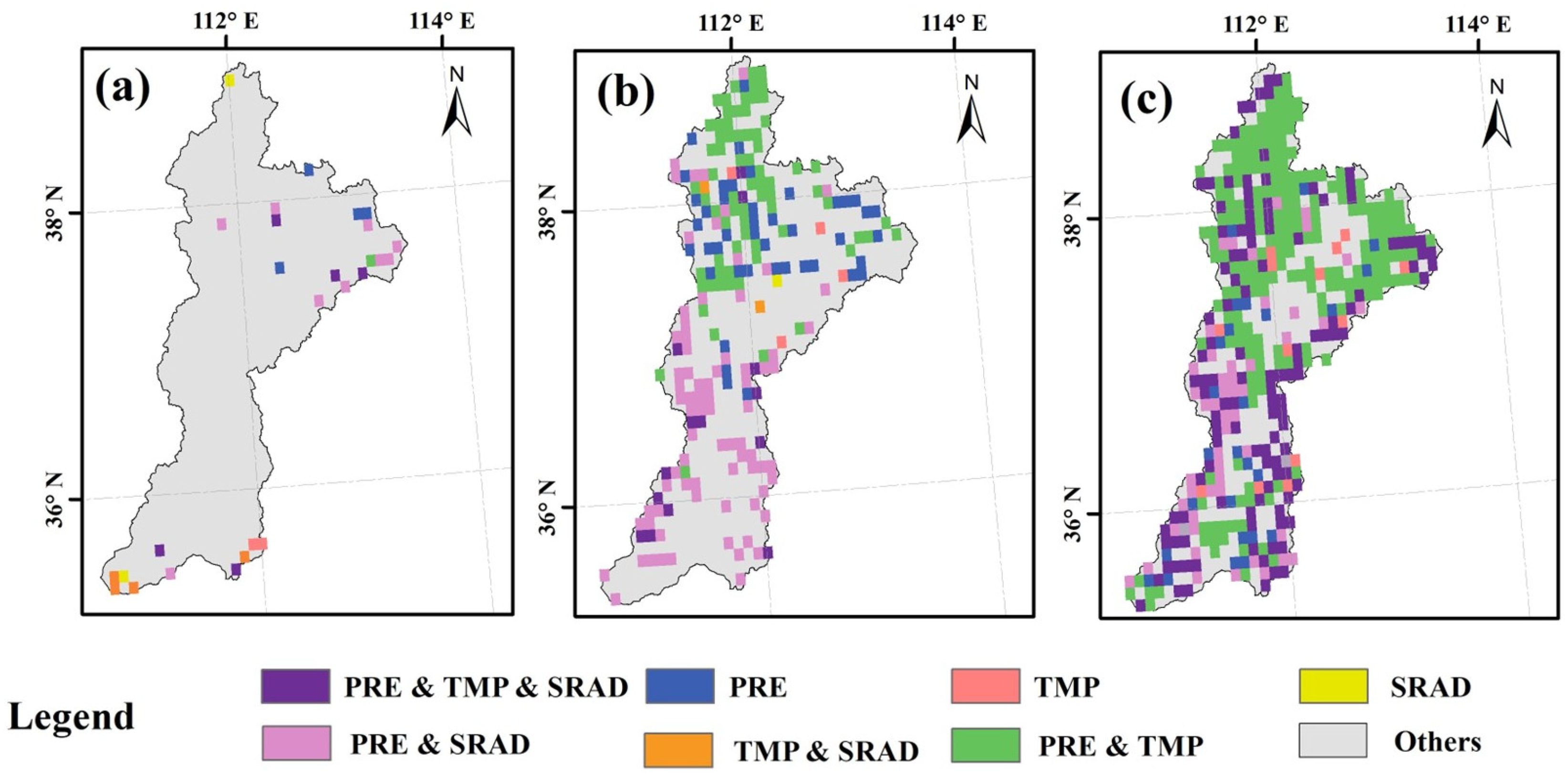
3.3.2. Influencing Vegetation Changes Linked to Climate Variation

Figure 7 depicts the spatial arrangement of the MCC between kNDVI and key weather variables (PRE, TMP, SRAD) in the FRB. Before the implementation of the GGP, vegetation coverage in most areas of the basin was not significantly affected by climate change, with only 4.8% of the area showing a significant impact from multiple climate factors on regional kNDVI. After the project’s implementation, the vegetation’s response to climate change increased significantly, reaching 37.5%, especially in the upstream of the FRB. From 1982 to 2022, CC had a widespread effect on vegetation variation in the FRB, with 56.2% of the basin’s vegetation significantly affected by climate factors. The northern and eastern areas of the FRB exhibited higher multiple correlation coefficients. In these areas, kNDVI tended to increase with rising precipitation and average temperature, while it decreased with increased solar radiation. It is worth noting that in areas with relatively advanced urbanization, such as the Jinzhong area, rising meteorological factors may not lead to an increase in kNDVI.
Additionally, regions with significant partial and multiple correlations were superimposed to analyze the climate variables affecting vegetation dynamics in the FRB. The spatial distribution of vegetation affected by climate factors (Figure 8) was obtained based on the classification standard of vegetation dynamics-related climate drivers (Table 2). Prior to the adoption of the GGP, factors like rainfall, temperature, and sunlight had minimal influence on plant growth patterns. However, following these ecological projects, vegetation rapidly recovered and became more sensitive to meteorological elements. During the period 1982–2022, vegetation changes in the FRB were mainly driven by the interplay between PRE and TMP, impacting around 36.4% of the region, especially in the more arid sections of the basin’s upper and middle reaches. The next major factor was the collective effect of rainfall, mean temperature, and sunlight, impacting 21.3% of the basin, primarily along its eastern and western borders. These regions are predominantly mountainous and have high altitudes. Additionally, around 8.8% of the basin area was significantly influenced only by precipitation and solar radiation, mostly in the western woodland regions midstream and downstream. Regarding single climate variables, factors related to precipitation (including types a, b, e, f) significantly impacted 71.3% of the FRB area. Factors related to temperature (including types a, c, e, g) significantly affected 60.1% of the basin, and factors related to solar radiation (including a, d, f, g) significantly impacted 30.1% of the area. In summary, precipitation has been the primary driving factor affecting vegetation change in the FRB, with temperature the second. More than half of the area has been affected by the combined influence of precipitation and temperature. Moreover, sunlight significantly influences the plant life in the basin, affecting roughly 30% of the region, especially in the mountainous areas on the western and eastern borders.

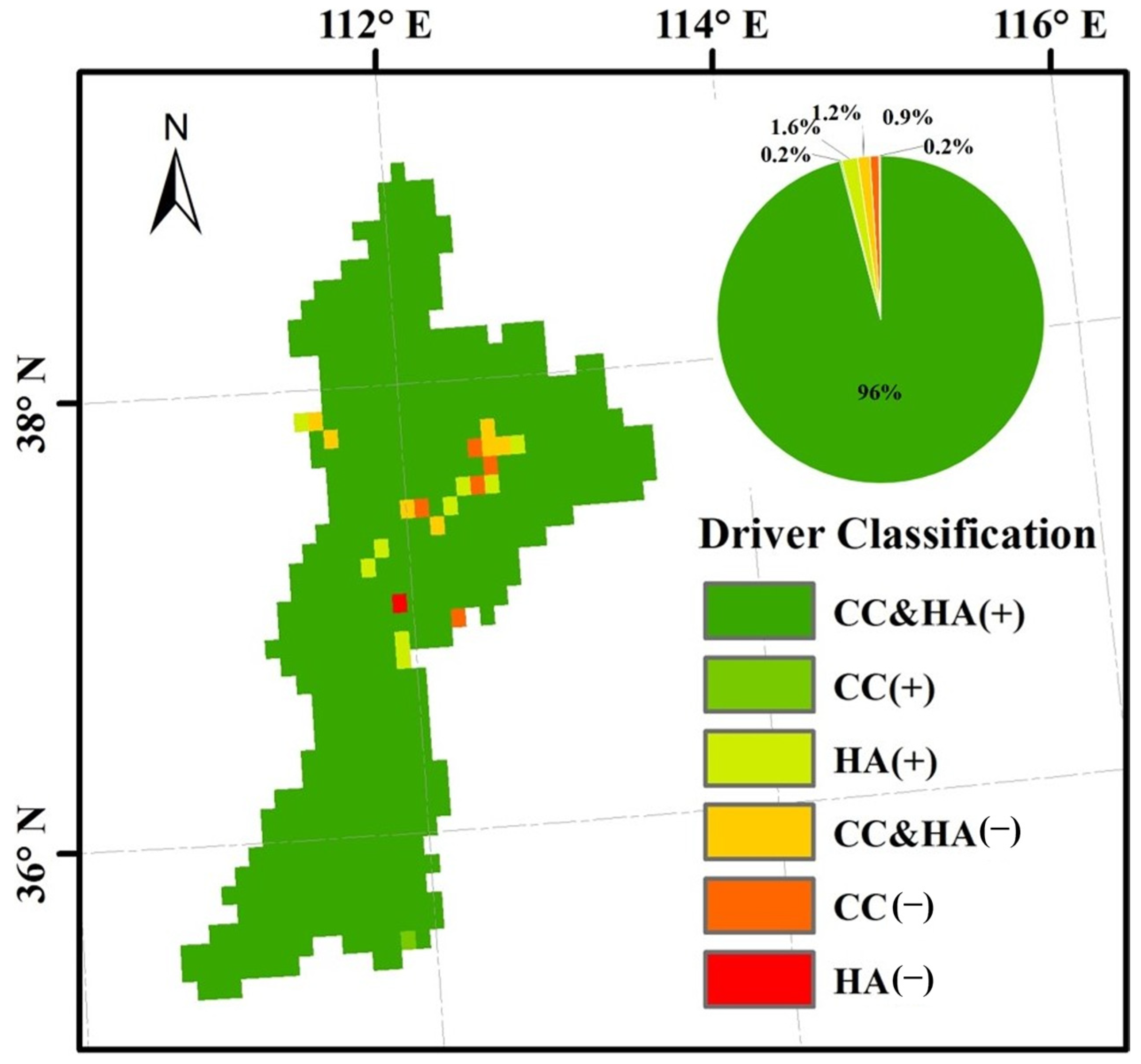
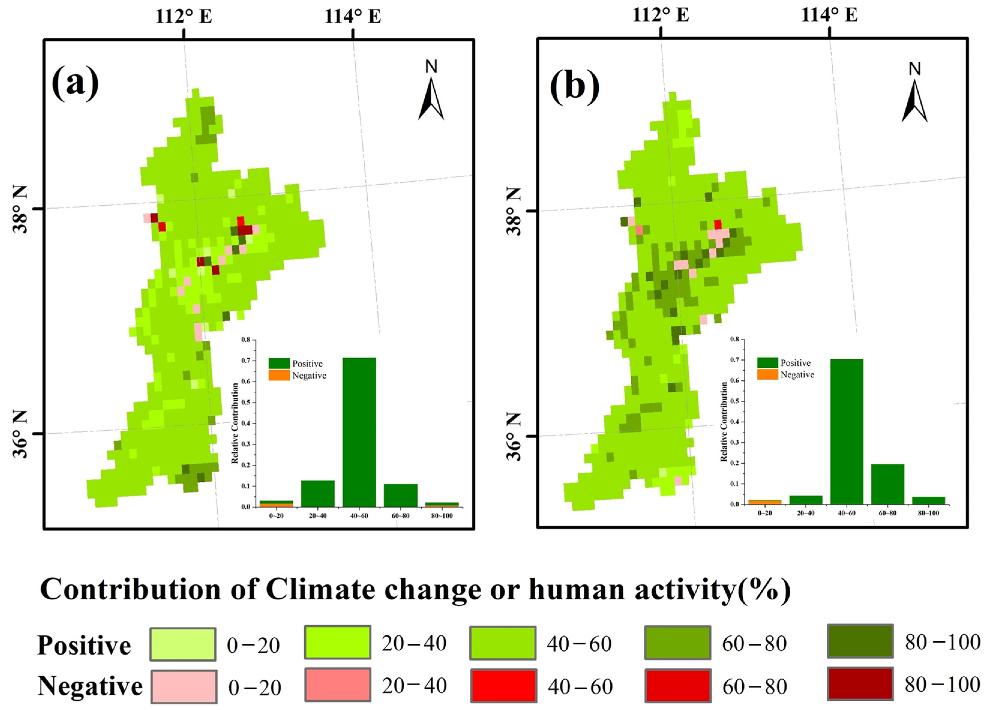
3.4. Influence of Climate and Human Activities on kNDVI

Utilizing the frameworks of residual and contribution analysis (Table 1), the distinct influences of climate change and human activity on vegetation variation in the FRB were quantitatively identified. Figure 9 illustrates the main driving elements of kNDVI variations in the FRB at pixel scale. Vegetation alterations in the basin exhibit considerable spatial variability due to climate change and human actions. As much as 96% of the plant life in the FRB is affected by CC and HA. Furthermore, the rise in kNDVI due to climate change and human actions has impacted just 0.2% and 1.6% of the FRB, mainly in cities. Moreover, in 2.3% of the FRB, the reduction in kNDVI has primarily been influenced by CC and HA, especially in cities.
The respective influences of CC and HA on vegetation changes in the FRB were assessed. In summary, CC and HA accounted for 47.8% and 52.2% of the kNDVI variations in the FRB, respectively (see Figure 10). Climate change positively contributed to vegetation dynamics across 97.0% of the FRB area. Among these areas, 71.2% of the FRB featured climate change contribution between 40% and 60%. Approximately 3.0% of the region experienced adverse effects from CC, while 7.8% had a contribution rate exceeding 60%, predominantly located in the Jinzhong area (see Figure 10a). Conversely, HA positively contributed to kNDVI changes in more than 97.7% of the FRB area. Similarly, approximately 70% of the area experienced HA effects with contribution rates between 40% and 60%. HA adversely affected kNDVI variations in 2.3% of the vegetated region, and its spatial pattern closely resembled that of the influence of climate change (Figure 10b).

4. Discussion

4.1. Variations over Time and Space in the Behavior of Plant Life and Climatic Elements

This research investigated the evolution of plant growth and weather patterns in the FRB by analyzing monthly KNDVI and climate metrics (rainfall, temperature, and sunlight) spanning from 1982 to 2022. The analysis focused on the spatial and temporal changes in vegetation and climate, comparing long-term trends with changes before and after the implementation of GGP. This study also evaluated the responses and contribution rates of these changes, offering a reference for assessing the effectiveness of the GGP.
Between 1982 and 2022, the FRB experienced substantial ecological improvement, with more than 90% of the region displaying a marked rise in kNDVI. This pattern aligns with research carried out in Loess Plateau and the Yellow River Basin, bolstering the reliability of the present results [38,56,57]. Following the initiation of ecological projects, the region’s vegetation condition markedly improved. In particular, the kNDVI change rate rose from 0.0005 yr−1 to 0.0052 yr−1, while the percentage of the region showing a notable increase expanded from 24.6% to 95.8%. These modifications underscore the beneficial effects of the GGP on the plant life within the FRB region [58,59]. However, rapid urbanization has led to increased degradation of vegetation, particularly in urban areas, underscoring the necessity of balancing urban development with ecological preservation [60].
Additionally, over the past four decades, the FRB has experienced considerable warming and a slight increase in humidity [61,62]. The spatial heterogeneity of the vegetation landscape in the FRB is influenced by varying water, thermal, and light conditions [63]. Most of the midstream and upstream areas of the FRB experience an arid or semi-arid climate, where water supply is the dominant limitation to plant growth [64,65]. In 76.1% of the basin, the kNDVI of the vegetation area showed a significant positive correlation with precipitation, indicating high sensitivity to moisture changes, particularly in the midstream and upstream [66,67]. In contrast, areas in the downstream exhibited a sparse distribution of significant positive correlation with precipitation, probably due to the prevalence of irrigation systems. These systems ensure a steady water supply but often result in increased cloud cover on rainy days, which reduces radiation and inhibits photosynthesis in vegetation [68]. Additionally, in regions less sensitive to precipitation changes, irrigation reduces the dependency of crop growth on natural precipitation.
In regions where water availability is sufficient, temperature significantly influences plant growth [69]. Increased temperatures can boost plant growth and affect seasonal cycles by lengthening the growing period and supplying essential warmth for plant development [70]. However, rising temperatures may increase evapotranspiration in water-restricted areas, particularly in arid regions, which can lead to reduced water supply and subsequently inhibit vegetation growth. While higher solar radiation promotes plant greening in mountainous areas, it can also intensify evapotranspiration, which impedes vegetation growth in dry and semidry areas [8]. It is crucial to recognize that although restoring vegetation can enhance regional warming and moisture levels, the heightened evapotranspiration from extensive plant growth might exacerbate water scarcity in the FRB. Liu et al. noted that current vegetation restoration efforts in the Yellow River Basin are nearing the threshold of the region’s water resource carrying capacity [71]. Hence, it is essential to account for the combined demands of water generation, usage, and consumption in the FRB and to modify environmental protection plans to harmonize plant growth with water availability. Moreover, after the execution of environmental initiatives, the responsiveness of plant life in the FRB to rainfall, mean temperature, and sunlight has heightened. This highlights the need for policymakers to develop sustainable ecological protection strategies that adapt to regional water resource conditions [72].

4.2. Impact of Climate Change and Human Activities on Plant Growth Patterns

Understanding the main factors and their impact on vegetation shifts is essential for grasping ecological transition mechanisms and enhancing conservation strategies. According to the results presented in Section 3.4, the combination of CC and HA has predominantly influenced vegetation variation in the FRB, with HA being the primary driver and CC being the second, accounting for 52.2% and 47.8% of the kNDVI change in the vegetation area, respectively. This finding is slightly different from those of relevant studies in the Loess Plateau [57], where CC and HA contributed 55.8% and 44.2% to vegetation changes. This may be because human activities such as the GGP, rapid urbanization, and grazing in the FRB have promoted vegetation more drastically than on the Loess Plateau as a whole. Conversely, unlike earlier research, this study includes a broader range of climate variables (whereas most prior studies focused solely on rainfall and temperature) and refreshes the variety and duration of the vegetation index (with most previous research utilizing NDVI data spanning from 1982 to 2015).
Our research revealed that HA was predominantly present around major and mid-sized urban centers, as well as in elevated mountainous areas. Different human-influenced areas exhibit varying driving mechanisms for vegetation growth. Since the early 20th century, numerous ecological initiatives have been the primary drivers of the restoration of vegetation in the FRB [57,73]. Figure 11 illustrates that prior to the GGP’s execution (1980–1999), land use change in the FRB was minimal, primarily consisting of transforming forest and grassland areas into agricultural land, leading to a net conversion of 85 square kilometers. After the GGP implementation, the main land use conversion shifted from farmland to forest and grassland, with a net conversion area of 708 square kilometers. The transformation of land categories between farmland, woodland, and pastureland demonstrates the effects of ecological conservation initiatives on local vegetation recovery [74].
Additionally, the rapid urbanization of the FRB over the past four decades has resulted in vegetation degradation in urban and surrounding areas [75]. During this time, significant amounts of farmland were converted into construction land to facilitate urban expansion, leading to a noticeable decline in vegetation in some regions. Balancing the beneficial and harmful effects of human actions on plant growth is essential to creating a harmonious coexistence between people and nature.

4.3. Limitations and Uncertainties

Spanning from 1982 to 2022, this research encompasses the most extensive NDVI dataset to date and addresses the saturation issues found in conventional vegetation indices, though certain uncertainties and constraints remain. Initially, incorporating additional data sources and employing various data fusion techniques can enhance spatial resolution and minimize uncertainties. Secondly, in addition to the three primary climate factors highlighted in this research, other possible influences like atmospheric CO2, water vapor pressure deficit (VPD), drought, soil moisture, and snow cover should also be considered. Additionally, regarding anthropogenic impacts, we have focused on land use change, while other anthropogenic related variables such as population density, nighttime lights, GDP, distance to roads, human modification index, grazing, etc., can be incorporated to better derive and attribute vegetation impacts to anthropogenic factors. Moreover, climate change typically influences plant growth in a complex, nonlinear way, and using residual analysis to attribute vegetation dynamics has its constraints, given this nonlinear relationship. Thus, in upcoming research, implementation of the time series segmentation and residual trend (TSS-RESTREND) method would be a more advanced approach for distinguishing between the contributions of climate variability and human activity to vegetation dynamics.

5. Conclusions

This study systematically assessed vegetation distribution change and its causes in the FRB by using kNDVI and key climate elements from 1982 to 2022. The study analyzed the spatial and temporal distribution of vegetation and climate shifts over various timeframes, the diverse reactions of variations in vegetation in response to these climatic changes, and the influence of climate change and human activity on alterations in vegetation. The main findings are summarized as follows:
In the past 40 years, notable variations in the spatial and temporal shifts in vegetation and reactions to climate change have been detected in the FRB, especially around the period of the GGP. Over 90% of the FRB showed notable greening, indicated by a kNDVI slope of 0.0028 per year (p < 0.001). The GGP hastened the greening process, causing the kNDVI slope to rise from 0.0005 yr−1 to 0.0052 yr−1, and the area presenting remarkable greening grew from 24.6% to 95.8%. in the FRB, climate change is mainly characterized by increased warming and humidity, with a slight increase in solar radiation. These findings highlight the substantial effect of ecological engineering on improving vegetation conditions in the FRB. The adoption of the GGP has heightened the reliance of plant life on climatic elements in the FRB, among which, rainfall has become the dominant climate factor while temperature and solar radiation also play important roles. In addition to the role of climate change, vegetation dynamics in the FRB are also influenced by the interplay of human actions. These findings improve the comprehension of the complex links between climate and variations in vegetation in the FRB, offering a theoretical basis for the formulation and improvement of relevant strategies for the FRB’s ecological protection.

Author Contributions

Conceptualization, K.N. and G.L.; methodology, A.K. and C.Z.; software, K.N.; validation, K.N. and C.Z.; formal analysis, K.N. and G.L.; data curation, K.N.; writing—original draft preparation, K.N.; writing—review and editing, C.Z. and A.K.; visualization, K.N.; supervision, C.Z. and G.L.; Funding acquisition, C.Z. and A.K. All authors have read and agreed to the published version of the manuscript.

Funding

This research was funded by the Basic Research Program of Shanxi Province (202303021212381); National Key Research and Development Program of China (2023YFC3006503).

Data Availability Statement

The Global Vegetation Greenness (NDVI) data from AVHRR GIMMS-3G+ (1982–2022) are available at https://daac.ornl.gov/cgi-bin/dsviewer.pl?ds_id=2187, accessed on 20 October 2023. The 1 km monthly precipitation dataset for China (1901–2022) is available at https://data.tpdc.ac.cn/zh-hans/data/faae7605-a0f2-4d18-b28f-5cee413766a2, accessed on 20 October 2023. The 1 km monthly mean temperature dataset for China (1901–2022) is available at https://data.tpdc.ac.cn/zh-hans/data/71ab4677-b66c-4fd1-a004-b2a541c4d5bf, accessed on 20 October 2023. The Terra Climate data is available at https://www.climatologylab.org/terraclimate.html, accessed on 20 October 2023. The CNLUCC dataset is available at https://www.resdc.cn/DOI/doi.aspx?DOIid=54, accessed on 15 October 2023.

Conflicts of Interest

The authors declare no conflicts of interest.

References

  1. He, Q.; Yang, Q.; Jiang, S.; Zhan, C. A Comprehensive Analysis of Vegetation Dynamics and Their Response to Climate Change in the Loess Plateau: Insight from Long-Term kernel Normalized Difference Vegetation Index Data. Forests 2024, 15, 471. [Google Scholar] [CrossRef]
  2. Zeng, Y.; Hao, D.; Huete, A.; Dechant, B.; Berry, J.; Chen, J.M.; Joiner, J.; Frankenberg, C.; Bond-Lamberty, B.; Ryu, Y.; et al. Optical vegetation indices for monitoring terrestrial ecosystems globally. Nat. Rev. Earth Environ. 2022, 3, 477–493. [Google Scholar] [CrossRef]
  3. Mottl, O.; Flantua, S.G.; Bhatta, K.P.; Felde, V.A.; Giesecke, T.; Goring, S.; Grimm, E.C.; Haberle, S.; Hooghiemstra, H.; Ivory, S.; et al. Global acceleration in rates of vegetation change over the past 18,000 years. Science 2021, 372, 860–864. [Google Scholar] [CrossRef]
  4. Chen, J.; Yan, F.; Lu, Q. Spatiotemporal Variation of Vegetation on the Qinghai–Tibet Plateau and the Influence of Climatic Factors and Human Activities on Vegetation Trend (2000–2019). Remote Sens. 2020, 12, 3150. [Google Scholar] [CrossRef]
  5. Liu, Z.; Wang, H.; Li, N.; Zhu, J.; Pan, Z.; Qin, F. Spatial and Temporal Characteristics and Driving Forces of Vegetation Changes in the Huaihe River Basin from 2003 to 2018. Sustainability 2020, 12, 2198. [Google Scholar] [CrossRef]
  6. Chen, C.; Park, T.; Wang, X.; Piao, S.; Xu, B.; Chaturvedi, R.K.; Fuchs, R.; Brovkin, V.; Ciais, P.; Fensholt, R.; et al. China and India lead in greening of the world through land-use management. Nat. Sustain. 2019, 2, 122–129. [Google Scholar] [CrossRef] [PubMed]
  7. Zhang, L.; Yang, L.; Zohner, C.M.; Crowther, T.W.; Li, M.; Shen, F.; Guo, M.; Qin, J.; Yao, L.; Zhou, C. Direct and indirect impacts of urbanization on vegetation growth across the world’s cities. Sci. Adv. 2022, 8, eabo0095. [Google Scholar] [CrossRef]
  8. De Beurs, K.M.; Henebry, G.M.; Owsley, B.C.; Sokolik, I. Using multiple remote sensing perspectives to identify and attribute land surface dynamics in Central Asia 2001–2013. Remote Sens. Environ. 2015, 170, 48–61. [Google Scholar] [CrossRef]
  9. Misra, G.; Cawkwell, F.; Wingler, A. Status of phenological research using Sentinel-2 data: A review. Remote Sens. 2020, 12, 2760. [Google Scholar] [CrossRef]
  10. Stagakis, S.; Markos, N.; Sykioti, O.; Kyparissis, A. Monitoring canopy biophysical and biochemical parameters in ecosystem scale using satellite hyperspectral imagery: An application on a Phlomis fruticosa Mediterranean ecosystem using multiangular CHRIS/PROBA observations. Remote Sens. Environ. 2010, 114, 977–994. [Google Scholar] [CrossRef]
  11. Feng, X.; Tian, J.; Wang, Y.; Wu, J.; Liu, J.; Ya, Q.; Li, Z. Spatio-temporal variation and climatic driving factors of vegetation coverage in the Yellow River Basin from 2001 to 2020 based on kNDVI. Forests 2023, 14, 620. [Google Scholar] [CrossRef]
  12. Liu, T.; Zhang, Q.; Li, T.; Zhang, K. Dynamic Vegetation Responses to Climate and Land Use Changes over the Inner Mongolia Reach of the Yellow River Basin, China. Remote Sens. 2023, 15, 3531. [Google Scholar] [CrossRef]
  13. Tsutsumida, N.; Shin, N.; Miura, T. Evaluation of land surface phenology for autumn leaf color change based on citizen reports across Japan. Remote Sens. 2022, 14, 2017. [Google Scholar] [CrossRef]
  14. Matsushita, B.; Yang, W.; Chen, J.; Onda, Y.; Qiu, G. Sensitivity of the enhanced vegetation index (EVI) and normalized difference vegetation index (NDVI) to topographic effects: A case study in high-density cypress forest. Sensors 2007, 7, 2636–2651. [Google Scholar] [CrossRef] [PubMed]
  15. Camps-Valls, G.; Campos-Taberner, M.; Moreno-Martínez, Á.; Walther, S.; Duveiller, G.; Cescatti, A.; Mahecha, M.D.; Muñoz-Marí, J.; García-Haro, F.J.; Guanter, L.; et al. A unified vegetation index for quantifying the terrestrial biosphere. Sci. Adv. 2021, 7, eabc7447. [Google Scholar] [CrossRef]
  16. Gu, Z.; Chen, X.; Ruan, W.; Zheng, M.; Gen, K.; Li, X.; Deng, H.; Chen, Y.; Liu, M. Quantifying the direct and indirect effects of terrain, climate and human activity on the spatial pattern of kNDVI-based vegetation growth: A case study from the Minjiang River Basin, Southeast China. Ecol. Inform. 2024, 80, 102493. [Google Scholar] [CrossRef]
  17. Wang, C.; Liu, L.; Zhou, Y.; Liu, X.; Wu, J.; Tan, W.; Xu, C.; Xiong, X. Comparison between Satellite Derived Solar-Induced Chlorophyll Fluorescence, NDVI and kNDVI in Detecting Water Stress for Dense Vegetation across Southern China. Remote Sens. 2024, 16, 1735. [Google Scholar] [CrossRef]
  18. Forzieri, G.; Dakos, V.; McDowell, N.G.; Ramdane, A.; Cescatti, A. Emerging signals of declining forest resilience under climate change. Nature 2022, 608, 534–539. [Google Scholar] [CrossRef] [PubMed]
  19. Wang, Q.; Moreno-Martínez, Á.; Muñoz-Marí, J.; Campos-Taberner, M.; Camps-Valls, G. Estimation of vegetation traits with kernel NDVI. ISPRS J. Photogramm. Remote Sens. 2023, 195, 408–417. [Google Scholar] [CrossRef]
  20. Bellini, E.; Moriondo, M.; Dibari, C.; Leolini, L.; Staglianò, N.; Stendardi, L.; Filippa, G.; Galvagno, M.; Argenti, G. Impacts of climate change on European grassland phenology: A 20-year analysis of MODIS satellite data. Remote Sens. 2022, 15, 218. [Google Scholar] [CrossRef]
  21. Nolan, C.; Overpeck, J.T.; Allen, J.R.; Anderson, P.M.; Betancourt, J.L.; Binney, H.A.; Brewer, S.; Bush, M.B.; Chase, B.M.; Cheddadi, R.; et al. Past and future global transformation of terrestrial ecosystems under climate change. Science 2018, 361, 920–923. [Google Scholar] [CrossRef]
  22. Zhan, C.; Liang, C.; Zhao, L.; Jiang, S.; Niu, K.; Zhang, Y.; Cheng, L. Detection and attribution of vegetation dynamics in the National Barrier Zone of China by considering climate temporal effects. Int. J. Appl. Earth Obs. Geoinf. 2023, 116, 103140. [Google Scholar] [CrossRef]
  23. Wu, D.; Zhao, X.; Liang, S.; Zhou, T.; Huang, K.; Tang, B.; Zhao, W. Time-lag effects of global vegetation responses to climate change. Glob. Chang. Biol. 2015, 21, 3520–3531. [Google Scholar] [CrossRef] [PubMed]
  24. Cheng, M.; Wang, Z.; Wang, S.; Liu, X.; Jiao, W.; Zhang, Y. Determining the impacts of climate change and human activities on vegetation change on the Chinese Loess Plateau considering human-induced vegetation type change and time-lag effects of climate on vegetation growth. Int. J. Digit. Earth 2024, 17, 2336075. [Google Scholar] [CrossRef]
  25. Piao, S.; Friedlingstein, P.; Ciais, P.; Zhou, L.; Chen, A. Effect of climate and CO2 changes on the greening of the Northern Hemisphere over the past two decades. Geophys. Res. Lett. 2006, 33, L23402. [Google Scholar] [CrossRef]
  26. Peng, X.; Zhang, T.; Frauenfeld, O.W.; Wang, S.; Qiao, L.; Du, R.; Mu, C. Northern Hemisphere greening in association with warming permafrost. J. Geophys. Res. Biogeosci. 2020, 125, e2019JG005086. [Google Scholar] [CrossRef]
  27. Liu, X.; Zhu, X.; Pan, Y.; Zhu, W.; Zhang, J.; Zhang, D. Thermal growing season and response of alpine grassland to climate variability across the Three-Rivers Headwater Region, China. Agric. For. Meteorol. 2016, 220, 30–37. [Google Scholar] [CrossRef]
  28. Porporato, A.; Laio, F.; Ridolfi, L.; Rodriguez-Iturbe, I. Plants in water-controlled ecosystems: Active role in hydrologic processes and response to water stress: III. Vegetation water stress. Adv. Water Resour. 2001, 24, 725–744. [Google Scholar] [CrossRef]
  29. Bodner, G.; Nakhforoosh, A.; Kaul, H.-P. Management of crop water under drought: A review. Agron. Sustain. Dev. 2015, 35, 401–442. [Google Scholar] [CrossRef]
  30. Lian, X.; Piao, S.; Chen, A.; Huntingford, C.; Fu, B.; Li, L.Z.X.; Huang, J.; Sheffield, J.; Berg, A.M.; Keenan, T.F.; et al. Multifaceted characteristics of dryland aridity changes in a warming world. Nat. Rev. Earth Environ. 2021, 2, 232–250. [Google Scholar] [CrossRef]
  31. Sun, R.; Chen, S.; Su, H. Climate dynamics of the spatiotemporal changes of vegetation NDVI in northern China from 1982 to 2015. Remote Sens. 2021, 13, 187. [Google Scholar] [CrossRef]
  32. Jiang, P.; Ding, W.; Yuan, Y.; Ye, W.; Mu, Y. Interannual variability of vegetation sensitivity to climate in China. J. Environ. Manag. 2022, 301, 113768. [Google Scholar] [CrossRef] [PubMed]
  33. Bonan, G.B.; Pollard, D.; Thompson, S.L. Effects of boreal forest vegetation on global climate. Nature 1992, 359, 716–718. [Google Scholar] [CrossRef]
  34. Lü, Y.; Zhang, L.; Feng, X.; Zeng, Y.; Fu, B.; Yao, X.; Li, J.; Wu, B. Recent ecological transitions in China: Greening, browning and influential factors. Sci. Rep. 2015, 5, 8732. [Google Scholar] [CrossRef] [PubMed]
  35. van Vliet, J. Direct and indirect loss of natural area from urban expansion. Nat. Sustain. 2019, 2, 755–763. [Google Scholar] [CrossRef]
  36. Zhou, W.; Zhang, S.; Yu, W.; Wang, J.; Wang, W. Effects of urban expansion on forest loss and fragmentation in six megaregions, China. Remote Sens. 2017, 9, 991. [Google Scholar] [CrossRef]
  37. Shao, W.; Cai, J.; Liu, J.; Luan, Q.; Mao, X.; Yang, G.; Wang, J.; Zhang, H.; Zhang, J. Impact of water scarcity on the Fenhe River Basin and mitigation strategies. Water 2017, 9, 30. [Google Scholar] [CrossRef]
  38. Guo, W.; He, H.; Li, X.; Zeng, W. Greater Greening Trend in the Loess Plateau of China Inferred from Long-Term Remote Sensing Data: Patterns, Causes and Implications. Forests 2022, 13, 1630. [Google Scholar] [CrossRef]
  39. Cai, D.; Ge, Q.; Wang, X.; Liu, B.; Goudie, A.S.; Hu, S. Contributions of ecological programs to vegetation restoration in arid and semiarid China. Environ. Res. Lett. 2020, 15, 114046. [Google Scholar] [CrossRef]
  40. Zastrow, M. China’s tree-planting could falter in a warming world. Nature 2019, 573, 474–475. [Google Scholar] [CrossRef]
  41. Liu, Y.; Li, Y.; Li, S.; Motesharrei, S. Spatial and temporal patterns of global NDVI trends: Correlations with climate and human factors. Remote Sens. 2015, 7, 13233–13250. [Google Scholar] [CrossRef]
  42. Kong, D.; Zhang, Q.; Singh, V.P.; Shi, P. Seasonal vegetation response to climate change in the Northern Hemisphere (1982–2013). Glob. Planet. Chang. 2017, 148, 1–8. [Google Scholar] [CrossRef]
  43. Du, Y.; Li, J.; Niu, K.; Feng, P.; Hu, Q.; Zheng, Y. Analysis of vegetation change and its impact on natural runoff in the mountain area of the Yongding River Basin from 1982 to 2015. J. Hydraul. Eng. 2021, 52, 1309–1323. [Google Scholar]
  44. Tian, F.; Liu, L.-Z.; Yang, J.-H.; Wu, J.-J. Vegetation greening in more than 94% of the Yellow River Basin (YRB) region in China during the 21st century caused jointly by warming and anthropogenic activities. Ecol. Indic. 2021, 125, 107479. [Google Scholar] [CrossRef]
  45. Ren, Z.; Tian, Z.; Wei, H.; Liu, Y.; Yu, Y. Spatiotemporal evolution and driving mechanisms of vegetation in the Yellow River Basin, China during 2000–2020. Ecol. Indic. 2022, 138, 108832. [Google Scholar] [CrossRef]
  46. Jin, K.; Wang, F.; Han, J.; Shi, S.; Ding, W. Contribution of climatic change and human activities to vegetation NDVI change over China during 1982–2015. Acta Geogr. Sin. 2020, 75, 961–974. [Google Scholar]
  47. Sun, R.; Chen, S.; Su, H. Trend analysis and driving factors of vegetation dynamics in northern China from 1982 to 2015. Remote Sens. 2022, 14, 6163. [Google Scholar] [CrossRef]
  48. Li, H.; Li, B.; Ge, L.; Han, C.; Yang, Q.; Zhang, Y. Temporal and Spatial Characteristics of Vegetation Evolution and Topographic Effects in Fenhe River Basin from 2000 to 2021. Ecol. Environ. Res. Lett. 2023, 32, 439–449. [Google Scholar]
  49. Cai, Y.; Zhang, F.; Duan, P.; Jim, C.Y.; Chan, N.W.; Shi, J.; Liu, C.; Wang, J.; Bahtebay, J.; Ma, X. Vegetation cover changes in China induced by ecological restoration-protection projects and land-use changes from 2000 to 2020. CATENA 2022, 217, 106530. [Google Scholar] [CrossRef]
  50. Peng, S.; Ding, Y.; Liu, W.; Li, Z. 1 km monthly temperature and precipitation dataset for China from 1901 to 2017. Earth Syst. Sci. Data 2019, 11, 1931–1946. [Google Scholar] [CrossRef]
  51. Abatzoglou, J.T.; Dobrowski, S.Z.; Parks, S.A.; Hegewisch, K.C. TerraClimate, a high-resolution global dataset of monthly climate and climatic water balance from 1958–2015. Sci. Data 2018, 5, 170191. [Google Scholar] [CrossRef] [PubMed]
  52. Trevisani, S.; Skrypitsyna, T.; Florinsky, I. Global digital elevation models for terrain morphology analysis in mountain environments: Insights on Copernicus GLO-30 and ALOS AW3D30 for a large Alpine area. Environ. Earth Sci. 2023, 82, 198. [Google Scholar] [CrossRef]
  53. Erilli, N.A. Use of trimean in theil-Sen regression analysis. Bull. Econ. Theory Anal. 2021, 6, 15–26. [Google Scholar] [CrossRef]
  54. Mann, H.B. Nonparametric tests against trend. Econom. J. Econom. Soc. 1945, 13, 245–259. [Google Scholar] [CrossRef]
  55. Liu, Y.; Wang, X.; Guo, M.; Tani, H.; Matsuoka, N.; Matsumura, S. Spatial and temporal relationships among NDVI, climate factors, and land cover changes in Northeast Asia from 1982 to 2009. GISci. Remote Sens. 2011, 48, 371–393. [Google Scholar] [CrossRef]
  56. Shi, S.; Yu, J.; Wang, F.; Wang, P.; Zhang, Y.; Jin, K. Quantitative contributions of climate change and human activities to vegetation changes over multiple time scales on the Loess Plateau. Sci. Total Environ. 2021, 755, 142419. [Google Scholar] [CrossRef] [PubMed]
  57. Li, W.; Zhou, J.; Xu, Z.; Liang, Y.; Shi, J.; Zhao, X. Climate impact greater on vegetation NPP but human enhance benefits after the Grain for Green Program in Loess Plateau. Ecol. Indic. 2023, 157, 111201. [Google Scholar] [CrossRef]
  58. Ni, X.; Guo, W.; Li, X.; Li, S. Heterogeneity of increases in net primary production under intensified human activity and climate variability on the Loess Plateau of China. Remote Sens. 2022, 14, 4706. [Google Scholar] [CrossRef]
  59. Liu, Y.; Yang, P.; Zhang, Z.; Zhang, W.; Wang, Z.; Zhang, Z.; Ren, H.; Zhou, R.; Wen, Z.; Hu, T. Diverse responses of grassland dynamics to climatic and anthropogenic factors across the different time scale in China. Ecol. Indic. 2021, 132, 108341. [Google Scholar] [CrossRef]
  60. Liu, J.; Wang, H.; Tang, B.; Hui, L.; Zhang, W.; Zhang, L.; Jiao, L. Analysis of Temporal and Spatial Dynamics of Ecosystem Services and Trade-Offs/Synergies during Urbanization in the Loess Plateau, China. Land 2023, 12, 2136. [Google Scholar] [CrossRef]
  61. Yang, J.; Zhang, Q.; Lu, G.; Liu, X.; Wang, Y.; Wang, D.; Liu, W.; Yue, P.; Zhu, B.; Duan, X. Climate transition from warm-dry to warm-wet in Eastern Northwest China. Atmosphere 2021, 12, 548. [Google Scholar] [CrossRef]
  62. Zhang, Q.; Yang, J.; Wang, W.; Ma, P.; Lu, G.; Liu, X.; Yu, H.; Fang, F. Climatic warming and humidification in the arid region of Northwest China: Multi-scale characteristics and impacts on ecological vegetation. J. Meteorol. Res. 2021, 35, 113–127. [Google Scholar] [CrossRef]
  63. Wang, X.; Shi, S.; Zhao, X.; Hu, Z.; Hou, M.; Xu, L. Detecting spatially non-stationary between vegetation and related factors in the Yellow River Basin from 1986 to 2021 using multiscale geographically weighted regression based on Landsat. Remote Sens. 2022, 14, 6276. [Google Scholar] [CrossRef]
  64. Zhao, A.; Wang, D.; Xiang, K.; Zhang, A. Vegetation photosynthesis changes and response to water constraints in the Yangtze River and Yellow River Basin, China. Ecol. Indic. 2022, 143, 109331. [Google Scholar] [CrossRef]
  65. Qin, G.; Meng, Z.; Fu, Y. Drought and water-use efficiency are dominant environmental factors affecting greenness in the Yellow River Basin, China. Sci. Total Environ. 2022, 834, 155479. [Google Scholar] [CrossRef] [PubMed]
  66. Ren, Y.; Liu, J.; Liu, S.; Wang, Z.; Liu, T.; Shalamzari, M.J. Effects of climate change on vegetation growth in the Yellow River Basin from 2000 to 2019. Remote Sens. 2022, 14, 687. [Google Scholar] [CrossRef]
  67. Zhan, C.; Liang, C.; Zhao, L.; Jiang, S.; Niu, K.; Zhang, Y. Drought-related cumulative and time-lag effects on vegetation dynamics across the Yellow River Basin, China. Ecol. Indic. 2022, 143, 109409. [Google Scholar] [CrossRef]
  68. Cao, Y.; Li, H.; Liu, Y.; Zhang, Y.; Jiang, Y.; Dai, W.; Shen, M.; Guo, X.; Qi, W.; Li, L.; et al. Regional Contribution and Attribution of the Interannual Variation of Net Primary Production in the Yellow River Basin, China. Remote Sens. 2023, 15, 5212. [Google Scholar] [CrossRef]
  69. Wang, Y.; Wang, X.; Wang, Q. Temporal and Spatial Changes of Vegetation Phenology and Their Response to Climate in the Yellow River Basin. IEEE Access 2023, 11, 141776–141788. [Google Scholar] [CrossRef]
  70. Fu, J.; Gong, Y.; Zheng, W.; Zou, J.; Zhang, M.; Zhang, Z.; Qin, J.; Liu, J.; Quan, B. Spatial-temporal variations of terrestrial evapotranspiration across China from 2000 to 2019. Sci. Total Environ. 2022, 825, 153951. [Google Scholar] [CrossRef] [PubMed]
  71. Zhou, J.; Liu, Q.; Liang, L.; Yan, D.; Yang, Y.; Wang, X.; Sun, T.; Li, S.; Gan, L.; Wu, J. Water constraints enhanced by revegetation while alleviated by increased precipitation on China’s water-dominated Loess Plateau. J. Hydrol. 2024, 640, 131731. [Google Scholar] [CrossRef]
  72. Brinkman, R.; Sombroek, W.G. The effects of global change on soil conditions in relation to plant growth and food production. In Global Climate Change and Agricultural Production; FAO: Rome, Italy, 1996; pp. 49–63. [Google Scholar]
  73. Wu, X.; Wang, S.; Fu, B.; Liu, J. Spatial variation and influencing factors of the effectiveness of afforestation in China’s Loess Plateau. Sci. Total Environ. 2021, 771, 144904. [Google Scholar] [CrossRef] [PubMed]
  74. Zhang, Q.; Wang, G.; Yuan, R.; Singh, V.P.; Wu, W.; Wang, D. Dynamic responses of ecological vulnerability to land cover shifts over the Yellow River Basin, China. Ecol. Indic. 2022, 144, 109554. [Google Scholar] [CrossRef]
  75. Zang, Y.; Yu, B.; Wu, C.; Zhao, Z. Spatiotemporal evolution of growing-season vegetation coverage and its natural-human drivers in the Yellow River Basin, China. Land Degrad. Dev. 2023, 34, 5849–5862. [Google Scholar] [CrossRef]
Figure 1. Geographic maps illustrating (a) the Fen River Basin’s location in China, (b) its topographical categorization, and (c) the distribution of primary vegetation types.
Forests 15 01733 g001
Figure 2. Spatial distribution of the average annual (a) kNDVI, (b) precipitation, (c) mean temperature, and (d) solar radiation in the Fen River Basin.
Forests 15 01733 g002
Figure 3. Multi-year average monthly change in (a) kNDVI, (b) precipitation, (c) temperature, and (d) solar radiation in the Fen River Basin.
Forests 15 01733 g003
Figure 4. Temporal patterns for kNDVI and climatic factors in (a) the whole area of the Fen River Basin, (b) the upstream of the Fen River Basin, (c) the midstream of the Fen River Basin, and (d) the downstream of the Fen River Basin during the periods 1982–1999, 2000–2022, and 1982–2022.
Forests 15 01733 g004
Figure 5. The spatial patterns of climate elements and kNDVI in the Fen River Basin for the different periods: (ad) the spatial patterns of KNDVI, precipitation, temperature, and radiation for the periods 1982–1999; (eh) the spatial patterns of KNDVI, precipitation, temperature, and radiation for the periods 2000–2022; (il) the spatial patterns of KNDVI, precipitation, temperature, and radiation for the periods 1982–2022.
Forests 15 01733 g005
Figure 6. The spatial patterns of partial correlation coefficients between kNDVI and KNDVI, precipitation, temperature, and solar radiation in the Fen River Basin for the different periods: (ac) the spatial patterns of partial correlation coefficients between KNDVI, precipitation, temperature, and solar radiation for the period 1982–1999; (df) the spatial patterns of partial correlation coefficients between KNDVI, precipitation, temperature, and solar radiation for the period 2000–2022; (gi) the spatial patterns of partial correlation coefficients between KNDVI, precipitation, temperature, and solar radiation for the period 1982–2022.
Forests 15 01733 g006
Figure 7. The spatial patterns of multiple correlation coefficients (MCC) between kNDVI and climate elements in the Fen River Basin for the periods 1982–1999 (a), 2000–2022 (b), and 1982–2022 (c).
Forests 15 01733 g007
Figure 8. Geographical patterns of key climate variables influencing vegetation changes in the Fen River Basin from 1982 to 1999 (a), 2000 to 2022 (b), and the entire period from 1982 to 2022 (c).
Forests 15 01733 g008
Figure 9. Geographical patterns of vegetation variation drivers in the Fen River Basin between 1982 and 2022. Climate change and human activity are represented by CC and HA, respectively.
Forests 15 01733 g009
Figure 10. Geographical distribution of the influence of climate change (a) and human activity (b) on vegetation trends in the Fen River Basin from 1982 to 2022.
Forests 15 01733 g010
Figure 11. Land use changes in the Fen River Basin (a) from 1980 to 2000; (b) from 2000 to 2020.
Forests 15 01733 g011
Table 1. Quantitative differentiation of the relative contribution of the driving factors of vegetation variation.
Vegetation VariationSlopeobsSlopepreSloperesRelative Contribution (%)
Climate ChangeHuman Activities
Greening>0<0<00100
>0>0<01000
>0>0>0 S l o p e p r e S l o p e o b s × 100 % S l o p e r e s S l o p e o b s × 100 %
Degradation<0<0>00100
<0>0<01000
<0<0<0 S l o p e p r e S l o p e o b s × 100 % S l o p e r e s S l o p e o b s × 100 %
Table 2. Classification of vegetation-variation-related climate factors in the Fen River Basin.
TypeDriving FactorsClassification Criteria
P C C k N D V I , P R E P C C k N D V I , T E M P C C k N D V I , S R M C C
aPRE, TMP, and SRAD t < t 0.05 t < t 0.05 t < t 0.05 F < F 0.05
bPRE t < t 0.05 t t 0.05 t t 0.05
cTMP t t 0.05 t > t 0.05 t t 0.05
dSRAD t t 0.05 t t 0.05 t > t 0.05
ePRE and TMP t > t 0.05 t > t 0.05 t t 0.05
fPRE and SRAD t > t 0.05 t t 0.05 t > t 0.05
gTMP and SRAD t t 0.05 t > t 0.05 t > t 0.05
hOthers
Note: The partial correlation coefficients between kNDVI and PRE, TMP, and SRAD are denoted as P C C k N D V I , P R E , P C C k N D V I , T M P , and P C C k N D V I , S R A D , respectively. M C C indicates the overall correlation between kNDVI and various climate factors. t 0.05 and F 0.05 represent the importance levels of the t-test and F-test, respectively.
Disclaimer/Publisher’s Note: The statements, opinions and data contained in all publications are solely those of the individual author(s) and contributor(s) and not of MDPI and/or the editor(s). MDPI and/or the editor(s) disclaim responsibility for any injury to people or property resulting from any ideas, methods, instructions or products referred to in the content.

