


Effective UAV Photogrammetry for Forest Management: New Insights on Side Overlap and Flight Parameters

 ,
,  ,
,
Abstract

1. Introduction
2. Materials and Methods
2.1. Data Acquisition
2.1.1. Ground Control
2.1.2. UAV-SfM
2.1.3. ULS
2.2. Data Processing
2.2.1. Photogrammetric Processing
2.2.2. Point Cloud Processing
2.3. Data Analysis
2.3.1. Orthomosaic Quality Analysis
2.3.2. Individual Tree Detection
2.4. Statistical Analysis
3. Results
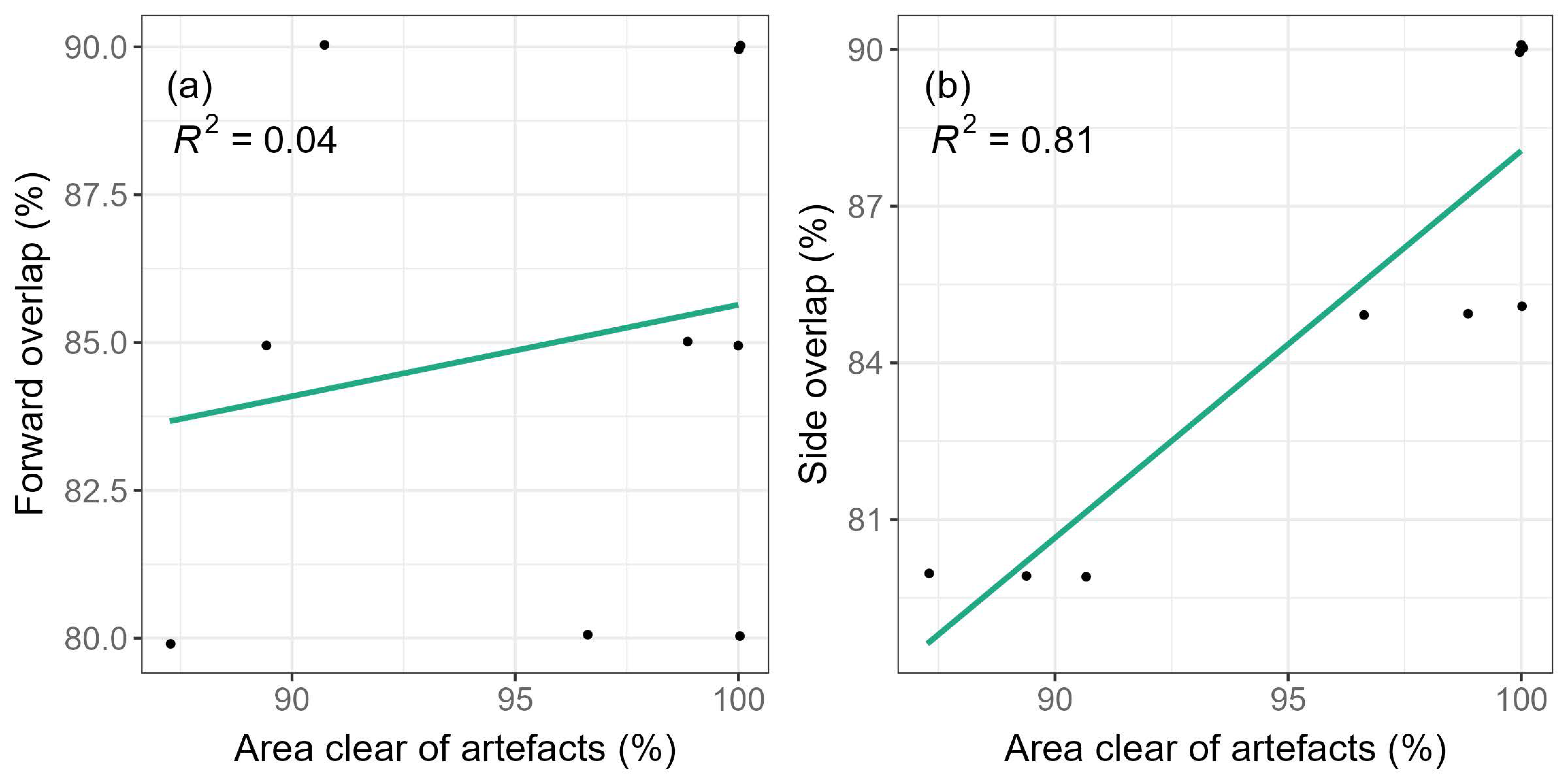
3.1. Orthomosaic Quality
3.2. Performance of Individual Tree Detection (ITD)
4. Discussion
4.1. UAV-SfM Orthomosaic Quality
4.2. Tree Detection Accuracy
4.3. Operational Recommendations
5. Conclusions
Author Contributions
Funding
Data Availability Statement
Acknowledgments
Conflicts of Interest
References
- Millar, C.I.; Stephenson, N.L. Temperate forest health in an era of emerging megadisturbance. Science 2015, 349, 823–826. [Google Scholar] [CrossRef] [PubMed]
- Nyland, R.D. Silviculture: Concepts and Applications; Waveland Press: Long Grove, IL, USA, 2016. [Google Scholar]
- O’Hara, K.L.; Gersonde, R.F. Stocking control concepts in uneven-aged silviculture. Forestry 2004, 77, 131–143. [Google Scholar] [CrossRef]
- Hartley, R. Unmanned aerial vehicles in forestry-reaching for a new perspective. NZ J. For. 2017, 62, 31–39. [Google Scholar]
- Williams, M.S. Comparison of estimation techniques for a forest inventory in which double sampling for stratification is used. For. Sci. 2001, 47, 563–576. [Google Scholar] [CrossRef]
- Bayne, K.M.; Parker, R.J. The introduction of robotics for New Zealand forestry operations: Forest sector employee perceptions and implications. Technol. Soc. 2012, 34, 138–148. [Google Scholar] [CrossRef]
- Brosofske, K.D.; Froese, R.E.; Falkowski, M.J.; Banskota, A. A review of methods for mapping and prediction of inventory attributes for operational forest management. For. Sci. 2014, 60, 733–756. [Google Scholar] [CrossRef]
- Goulding, C. Measurement of trees. In Forestry Handbook; New Zealand Institute of Forestry: Christchurch, New Zealand, 2005; pp. 145–148. [Google Scholar]
- McRoberts, R.E.; Tomppo, E.O. Remote sensing support for national forest inventories. Remote Sens. Environ. 2007, 110, 412–419. [Google Scholar] [CrossRef]
- Heaphy, M.; Watt, M.S.; Dash, J.P.; Pearse, G.D. UAVs for data collection-plugging the gap. NZ J. For. 2017, 62, 23–30. [Google Scholar]
- Zhang, Z.; Zhu, L. A review on unmanned aerial vehicle remote sensing: Platforms, sensors, data processing methods, and applications. Drones 2023, 7, 398. [Google Scholar] [CrossRef]
- Arango, C.; Morales, C. Comparison between multicopter UAV and total station for estimating stockpile volumes. Int. Arch. Photogramm. Remote Sens. Spat. Inf. Sci. 2015, 40, 131–135. [Google Scholar] [CrossRef]
- Dandois, J.P.; Ellis, E.C. High spatial resolution three-dimensional mapping of vegetation spectral dynamics using computer vision. Remote Sens. Environ. 2013, 136, 259–276. [Google Scholar] [CrossRef]
- Puliti, S.; Ørka, H.O.; Gobakken, T.; Næsset, E. Inventory of small forest areas using an unmanned aerial system. Remote Sens. 2015, 7, 9632–9654. [Google Scholar] [CrossRef]
- White, J.C.; Coops, N.C.; Wulder, M.A.; Vastaranta, M.; Hilker, T.; Tompalski, P. Remote Sensing Technologies for Enhancing Forest Inventories: A Review. Can. J. Remote Sens. 2016, 42, 619–641. [Google Scholar] [CrossRef]
- Singh, K.K.; Surasinghe, T.D.; Frazier, A.E. Systematic review and best practices for drone remote sensing of invasive plants. Methods Ecol. Evol. 2024, 15, 998–1015. [Google Scholar] [CrossRef]
- Hillman, S.; Wallace, L.; Lucieer, A.; Reinke, K.; Turner, D.; Jones, S. A comparison of terrestrial and UAS sensors for measuring fuel hazard in a dry sclerophyll forest. Int. J. Appl. Earth Obs. Geoinf. 2021, 95, 102261. [Google Scholar] [CrossRef]
- Duarte, A.; Borralho, N.; Cabral, P.; Caetano, M. Recent advances in forest insect pests and diseases monitoring using UAV-based data: A systematic review. Forests 2022, 13, 911. [Google Scholar] [CrossRef]
- Mohan, M.; Leite, R.V.; Broadbent, E.N.; Wan Mohd Jaafar, W.S.; Srinivasan, S.; Bajaj, S.; Dalla Corte, A.P.; do Amaral, C.H.; Gopan, G.; Saad, S.N.M. Individual tree detection using UAV-lidar and UAV-SfM data: A tutorial for beginners. Open Geosci. 2021, 13, 1028–1039. [Google Scholar] [CrossRef]
- Persson, Å.; Holmgren, J.; Söderman, U. Detecting and measuring individual trees using an airborne laser scanner. Photogramm. Eng. Remote Sens. 2002, 68, 925–932. [Google Scholar]
- Wulder, M.A.; White, J.C.; Fournier, R.A.; Luther, J.E.; Magnussen, S. Spatially explicit large area biomass estimation: Three approaches using forest inventory and remotely sensed imagery in a GIS. Sensors 2008, 8, 529–560. [Google Scholar] [CrossRef]
- Rodríguez-Puerta, F.; Gómez-García, E.; Martín-García, S.; Pérez-Rodríguez, F.; Prada, E. UAV-based LiDAR scanning for individual tree detection and height measurement in young forest permanent trials. Remote Sens. 2021, 14, 170. [Google Scholar] [CrossRef]
- Coomes, D.A.; Dalponte, M.; Jucker, T.; Asner, G.P.; Banin, L.F.; Burslem, D.F.; Lewis, S.L.; Nilus, R.; Phillips, O.L.; Phua, M.-H. Area-based vs tree-centric approaches to mapping forest carbon in Southeast Asian forests from airborne laser scanning data. Remote Sens. Environ. 2017, 194, 77–88. [Google Scholar] [CrossRef]
- Holopainen, M.; Vastaranta, M.; Hyyppä, J. Outlook for the next generation’s precision forestry in Finland. Forests 2014, 5, 1682–1694. [Google Scholar] [CrossRef]
- Watt, M.S.; Jayathunga, S.; Hartley, R.J.; Pearse, G.D.; Massam, P.D.; Cajes, D.; Steer, B.S.; Estarija, H.J.C. Use of a Consumer-Grade UAV Laser Scanner to Identify Trees and Estimate Key Tree Attributes across a Point Density Range. Forests 2024, 15, 899. [Google Scholar] [CrossRef]
- Camarretta, N.; Harrison, P.A.; Bailey, T.; Potts, B.; Lucieer, A.; Davidson, N.; Hunt, M. Monitoring forest structure to guide adaptive management of forest restoration: A review of remote sensing approaches. New For. 2020, 51, 573–596. [Google Scholar] [CrossRef]
- Hartley, R.J.L.; Leonardo, E.M.; Massam, P.; Watt, M.S.; Estarija, H.J.; Wright, L.; Melia, N.; Pearse, G.D. An assessment of high-density UAV point clouds for the measurement of young forestry trials. Remote Sens. 2020, 12, 4039. [Google Scholar] [CrossRef]
- Bruggisser, M.; Hollaus, M.; Kükenbrink, D.; Pfeifer, N. Comparison of forest structure metrics derived from UAV lidar and ALS data. ISPRS Ann. Photogramm. Remote Sens. Spat. Inf. Sci. 2019, 4, 325–332. [Google Scholar] [CrossRef]
- Iglhaut, J.; Cabo, C.; Puliti, S.; Piermattei, L.; O’Connor, J.; Rosette, J. Structure from motion photogrammetry in forestry: A review. Curr. For. Rep. 2019, 5, 155–168. [Google Scholar] [CrossRef]
- Dandois, J.P.; Ellis, E.C. Remote sensing of vegetation structure using computer vision. Remote Sens. 2010, 2, 1157–1176. [Google Scholar] [CrossRef]
- Lisein, J.; Pierrot-Deseilligny, M.; Bonnet, S.; Lejeune, P. A photogrammetric workflow for the creation of a forest canopy height model from small unmanned aerial system imagery. Forests 2013, 4, 922–944. [Google Scholar] [CrossRef]
- Tuominen, S.; Balazs, A.; Saari, H.; Pölönen, I.; Sarkeala, J.; Viitala, R. Unmanned aerial system imagery and photogrammetric canopy height data in area-based estimation of forest variables. Silva Fenn. 2015, 49, 1348. [Google Scholar] [CrossRef]
- Zhu, R.; Guo, Z.; Zhang, X. Forest 3D reconstruction and individual tree parameter extraction combining close-range photo enhancement and feature matching. Remote Sens. 2021, 13, 1633. [Google Scholar] [CrossRef]
- Dandois, J.P.; Olano, M.; Ellis, E.C. Optimal altitude, overlap, and weather conditions for computer vision UAV estimates of forest structure. Remote Sens. 2015, 7, 13895–13920. [Google Scholar] [CrossRef]
- Domingo, D.; Ørka, H.O.; Næsset, E.; Kachamba, D.; Gobakken, T. Effects of UAV image resolution, camera type, and image overlap on accuracy of biomass predictions in a tropical woodland. Remote Sens. 2019, 11, 948. [Google Scholar] [CrossRef]
- Frey, J.; Kovach, K.; Stemmler, S.; Koch, B. UAV photogrammetry of forests as a vulnerable process. A sensitivity analysis for a structure from motion RGB-image pipeline. Remote Sens. 2018, 10, 912. [Google Scholar] [CrossRef]
- Liang, X.; Kukko, A.; Balenovic, I.; Saarinen, N.; Junttila, S.; Kankare, V.; Holopainen, M.; Mokroš, M.; Surový, P.; Kaartinen, L. Close-Range Remote Sensing of Forests-The state of the art, challenges, and opportunities for systems and data acquisitions. IEEE Geosci. Remote Sens. Mag. 2022, 10, 32–71. [Google Scholar] [CrossRef]
- Ni, W.; Sun, G.; Pang, Y.; Zhang, Z.; Liu, J.; Yang, A.; Wang, Y.; Zhang, D. Mapping three-dimensional structures of forest canopy using UAV stereo imagery: Evaluating impacts of forward overlaps and image resolutions with LiDAR data as reference. IEEE J. Sel. Top. Appl. Earth Obs. Remote Sens. 2018, 11, 3578–3589. [Google Scholar] [CrossRef]
- Seifert, E.; Seifert, S.; Vogt, H.; Drew, D.; Van Aardt, J.; Kunneke, A.; Seifert, T. Influence of drone altitude, image overlap, and optical sensor resolution on multi-view reconstruction of forest images. Remote Sens. 2019, 11, 1252. [Google Scholar] [CrossRef]
- Pessacg, F.; Gómez-Fernández, F.; Nitsche, M.; Chamo, N.; Torrella, S.; Ginzburg, R.; De Cristóforis, P. Simplifying UAV-based photogrammetry in forestry: How to generate accurate digital terrain model and assess flight mission settings. Forests 2022, 13, 173. [Google Scholar] [CrossRef]
- Chappell, P.R. The Climate and Weather of Hawkes’s Bay. 2013. Available online: https://niwa.co.nz/node/110334 (accessed on 13 November 2024).
- Wagle, B.H.; Weiskittel, A.R.; Kizha, A.R.; Berrill, J.-P.; D’Amato, A.W.; Marshall, D. Long-term influence of commercial thinning on stand structure and yield with/without pre-commercial thinning of spruce-fir in northern Maine, USA. For. Ecol. Manag. 2022, 522, 120453. [Google Scholar] [CrossRef]
- Taylor, S.; Visser, R. Viability of Production Thinning in New Zealand; School of Forestry, University of Canterbury: Christchurch, New Zealand, 2021. [Google Scholar]
- Hartley, R.J.a.L.; Henderson, I.L.; Jackson, C.L. BVLOS Unmanned Aircraft Operations in Forest Environments. Drones 2022, 6, 167. [Google Scholar] [CrossRef]
- Torres-Sánchez, J.; López-Granados, F.; Borra-Serrano, I.; Peña, J.M. Assessing UAV-collected image overlap influence on computation time and digital surface model accuracy in olive orchards. Precis. Agric. 2018, 19, 115–133. [Google Scholar] [CrossRef]
- R Core Team. R: A Language and Environment for Statistical Computing; R Foundation for Statistical Computing: Vienna, Austria, 2022. [Google Scholar]
- Roussel, J.-R.; Auty, D.; Coops, N.C.; Tompalski, P.; Goodbody, T.R.; Meador, A.S.; Bourdon, J.-F.; De Boissieu, F.; Achim, A. lidR: An R package for analysis of Airborne Laser Scanning (ALS) data. Remote Sens. Environ. 2020, 251, 112061. [Google Scholar] [CrossRef]
- Zhang, W.; Qi, J.; Wan, P.; Wang, H.; Xie, D.; Wang, X.; Yan, G. An easy-to-use airborne LiDAR data filtering method based on cloth simulation. Remote Sens. 2016, 8, 501. [Google Scholar] [CrossRef]
- Wallace, L.; Lucieer, A.; Malenovský, Z.; Turner, D.; Vopěnka, P. Assessment of forest structure using two UAV techniques: A comparison of airborne laser scanning and structure from motion (SfM) point clouds. Forests 2016, 7, 62. [Google Scholar] [CrossRef]
- Khosravipour, A.; Skidmore, A.K.; Isenburg, M.; Wang, T.; Hussin, Y.A. Generating pit-free canopy height models from airborne lidar. Photogramm. Eng. Remote Sens. 2014, 80, 863–872. [Google Scholar] [CrossRef]
- Ludwig, M.; Runge, C.M.; Friess, N.; Koch, T.L.; Richter, S.; Seyfried, S.; Wraase, L.; Lobo, A.; Sebastià, M.-T.; Reudenbach, C. Quality assessment of photogrammetric methods—A workflow for reproducible UAS orthomosaics. Remote Sens. 2020, 12, 3831. [Google Scholar] [CrossRef]
- Gross, J.W.; Heumann, B.W. A statistical examination of image stitching software packages for use with unmanned aerial systems. Photogramm. Eng. Remote Sens. 2016, 82, 419–425. [Google Scholar] [CrossRef]
- Popescu, S.C.; Wynne, R.H. Seeing the Trees in the Forest. Photogramm. Eng. Remote Sens. 2004, 70, 589–604. [Google Scholar] [CrossRef]
- Lillesand, T.; Kiefer, R.W.; Chipman, J. Remote Sensing and Image Interpretation; John Wiley & Sons: Hoboken, NJ, USA, 2015. [Google Scholar]
- Al-Rawabdeh, A.; Habib, A.; He, F. Multi-sensory data integration for extracting geotechnical parameters for landslides hazard assessment. In Proceedings of the ASPRS 2014 Annual Conference, Louisville, KY, USA, 23–28 March 2014. [Google Scholar]
- Heipke, C.; Eder, K. Performance of Tie-Point Extraction in Automatic Aerial Triangulation; OEEPE: Paris, France, 1998; pp. 125–185. Available online: https://www.eurosdr.net/sites/default/files/uploaded_files/oeepe_publication_ndeg_35.pdf (accessed on 16 July 2024).
- Lipwoni, V.; Watt, M.S.; Hartley, R.J.; Leonardo, E.M.C.; Morgenroth, J. A comparison of photogrammetric software for deriving structure-from-motion 3D point clouds and estimating tree heights. NZ J. For. 2022, 66, 19. [Google Scholar]
- Rupnik, E.; Daakir, M.; Pierrot Deseilligny, M. MicMac–a free, open-source solution for photogrammetry. Open Geospat. Data Softw. Stand. 2017, 2, 14. [Google Scholar] [CrossRef]
- Wierzbicki, D.; Kedzierski, M.; Fryskowska, A. Assesment of the influence of UAV image quality on the orthophoto production. Int. Arch. Photogramm. Remote Sens. Spat. Inf. Sci. 2015, 40, 1–8. [Google Scholar] [CrossRef]
- Zali, S.-A.; Shahbe, M.; Che-Embi, Z.; Mohd-Isa, W.-N. Preliminary Study on Shadow Detection in Drone-Acquired Images with U-NET. In Proceedings of the International Conference on Computer, Information Technology and Intelligent Computing (CITIC 2022), Kuala Lumpur, Malaysia, 25–27 July 2022; pp. 357–368. [Google Scholar]
- Wu, X.; Shen, X.; Cao, L.; Wang, G.; Cao, F. Assessment of individual tree detection and canopy cover estimation using unmanned aerial vehicle based light detection and ranging (UAV-LiDAR) data in planted forests. Remote Sens. 2019, 11, 908. [Google Scholar] [CrossRef]
- Zaforemska, A.; Xiao, W.; Gaulton, R. Individual tree detection from UAV LiDAR data in a mixed species woodland. Int. Arch. Photogramm. Remote Sens. Spat. Inf. Sci. 2019, 42, 657–663. [Google Scholar] [CrossRef]
- Goldbergs, G.; Maier, S.W.; Levick, S.R.; Edwards, A. Efficiency of individual tree detection approaches based on light-weight and low-cost UAS imagery in Australian Savannas. Remote Sens. 2018, 10, 161. [Google Scholar] [CrossRef]
- Guerra-Hernández, J.; Cosenza, D.N.; Rodriguez, L.C.E.; Silva, M.; Tomé, M.; Díaz-Varela, R.A.; González-Ferreiro, E. Comparison of ALS-and UAV (SfM)-derived high-density point clouds for individual tree detection in Eucalyptus plantations. Int. J. Remote Sens. 2018, 39, 5211–5235. [Google Scholar] [CrossRef]
- Li, W.; Guo, Q.; Jakubowski, M.K.; Kelly, M. A new method for segmenting individual trees from the lidar point cloud. Photogramm. Eng. Remote Sens. 2012, 78, 75–84. [Google Scholar] [CrossRef]
- Mohan, M.; Silva, C.A.; Klauberg, C.; Jat, P.; Catts, G.; Cardil, A.; Hudak, A.T.; Dia, M. Individual tree detection from unmanned aerial vehicle (UAV) derived canopy height model in an open canopy mixed conifer forest. Forests 2017, 8, 340. [Google Scholar] [CrossRef]
- Pearse, G.D.; Tan, A.Y.; Watt, M.S.; Franz, M.O.; Dash, J.P. Detecting and mapping tree seedlings in UAV imagery using convolutional neural networks and field-verified data. ISPRS J. Photogramm. Remote Sens. 2020, 168, 156–169. [Google Scholar] [CrossRef]
- Ocer, N.E.; Kaplan, G.; Erdem, F.; Kucuk Matci, D.; Avdan, U. Tree extraction from multi-scale UAV images using Mask R-CNN with FPN. Remote Sens. Lett. 2020, 11, 847–856. [Google Scholar] [CrossRef]


| Mission ID | Planned GSD (cm/px) | Actual GSD (cm/px) | Altitude (m AGL) | Forward Overlap (%) | Side Overlap (%) | No. of Images |
|---|---|---|---|---|---|---|
| 1 | 2.19 | 2.34 | 80 | 80 | 80 | 975 |
| 2 | 2.19 | 2.32 | 80 | 80 | 85 | 1489 |
| 3 | 2.19 | 2.29 | 80 | 80 | 90 | 2265 |
| 4 | 2.19 | 2.27 | 80 | 85 | 80 | 1464 |
| 5 | 2.19 | 2.24 | 80 | 85 | 85 | 1856 |
| 6 | 2.19 | 2.28 | 80 | 85 | 90 | 2747 |
| 7 | 2.19 | 2.23 | 80 | 90 | 80 | 2047 |
| 8 | 2.19 | 2.29 | 80 | 90 | 85 | 2758 |
| 9 | 2.19 | 2.29 | 80 | 90 | 90 | 4199 |
| 10 | 3.2 | 3.43 | 120 | 80 | 80 | 804 |
| 11 | 3.2 | 3.4 | 120 | 80 | 85 | 920 |
| 12 | 3.2 | 3.35 | 120 | 80 | 90 | 977 |
| 13 | 3.2 | 3.35 | 120 | 85 | 80 | 710 |
| 14 | 3.2 | 3.33 | 120 | 85 | 85 | 930 |
| 15 | 3.2 | 3.41 | 120 | 85 | 90 | 1266 |
| 16 | 3.2 | 3.23 | 120 | 90 | 80 | 975 |
| 17 | 3.2 | 3.33 | 120 | 90 | 85 | 1229 |
| 18 | 3.2 | 3.32 | 120 | 90 | 90 | 1875 |
| Overlap (Fwd:Side) | Area Clear of Artefacts (ha) | Area Clear of Artefacts (%) | Flight Duration (mins) | |||
|---|---|---|---|---|---|---|
| 80 m AGL | 120 m AGL | 80 m AGL | 120 m AGL | 80 m AGL | 120 m AGL | |
| 80:80 | 24.9 | 26.18 | 83 | 87.3 | 98 | 58 |
| 80:85 | 27.47 | 28.99 | 91.5 | 96.6 | 150 | 84 |
| 80:90 | 29.65 | 30 | 98.8 | 100 | 213 | 118 |
| 85:80 | 29.75 | 26.82 | 99.2 | 89.4 | 98 | 58 |
| 85:85 | 30 | 29.65 | 100 | 98.8 | 150 | 84 |
| 85:90 | 30 | 30 | 100 | 100 | 213 | 118 |
| 90:80 | 30 | 27.21 | 100 | 90.7 | 134 | 60 |
| 90:85 | 27.55 | 30 | 91.8 | 100 | 187 | 87 |
| 90:90 | 28.76 | 30 | 95.9 | 100 | 270 | 111 |
| Side Overlap | ||||
|---|---|---|---|---|
| Forward Overlap | 80% | 85% | 90% | Range (%) |
| 80% | 87.3 | 96.6 | 100 | 12.7 |
| 85% | 89.4 | 98.8 | 100 | 10.6 |
| 90% | 90.7 | 100 | 100 | 9.3 |
| Range (%) | 3.4 | 3.4 | 0 | - |
| TP | FP | FN | Recall | Precision | F-Score | |
|---|---|---|---|---|---|---|
| UAV-SfM | 7203 | 207 | 1249 | 0.85 | 0.97 | 0.91 |
| ULS | 7921 | 439 | 531 | 0.94 | 0.95 | 0.94 |
Disclaimer/Publisher’s Note: The statements, opinions and data contained in all publications are solely those of the individual author(s) and contributor(s) and not of MDPI and/or the editor(s). MDPI and/or the editor(s) disclaim responsibility for any injury to people or property resulting from any ideas, methods, instructions or products referred to in the content. |
© 2024 by the authors. Licensee MDPI, Basel, Switzerland. This article is an open access article distributed under the terms and conditions of the Creative Commons Attribution (CC BY) license (https://creativecommons.org/licenses/by/4.0/).
Share and Cite
Dhruva, A.; Hartley, R.J.L.; Redpath, T.A.N.; Estarija, H.J.C.; Cajes, D.; Massam, P.D. Effective UAV Photogrammetry for Forest Management: New Insights on Side Overlap and Flight Parameters. Forests 2024, 15, 2135. https://doi.org/10.3390/f15122135
Dhruva A, Hartley RJL, Redpath TAN, Estarija HJC, Cajes D, Massam PD. Effective UAV Photogrammetry for Forest Management: New Insights on Side Overlap and Flight Parameters. Forests. 2024; 15(12):2135. https://doi.org/10.3390/f15122135
Chicago/Turabian StyleDhruva, Atman, Robin J. L. Hartley, Todd A. N. Redpath, Honey Jane C. Estarija, David Cajes, and Peter D. Massam. 2024. "Effective UAV Photogrammetry for Forest Management: New Insights on Side Overlap and Flight Parameters" Forests 15, no. 12: 2135. https://doi.org/10.3390/f15122135
APA StyleDhruva, A., Hartley, R. J. L., Redpath, T. A. N., Estarija, H. J. C., Cajes, D., & Massam, P. D. (2024). Effective UAV Photogrammetry for Forest Management: New Insights on Side Overlap and Flight Parameters. Forests, 15(12), 2135. https://doi.org/10.3390/f15122135