
What Drives the Spatial Variation of Interregional Ancient Trees? A Geoinformatics–Based Approach in Henan, Central China
Abstract
:1. Introduction
2. Data and Method
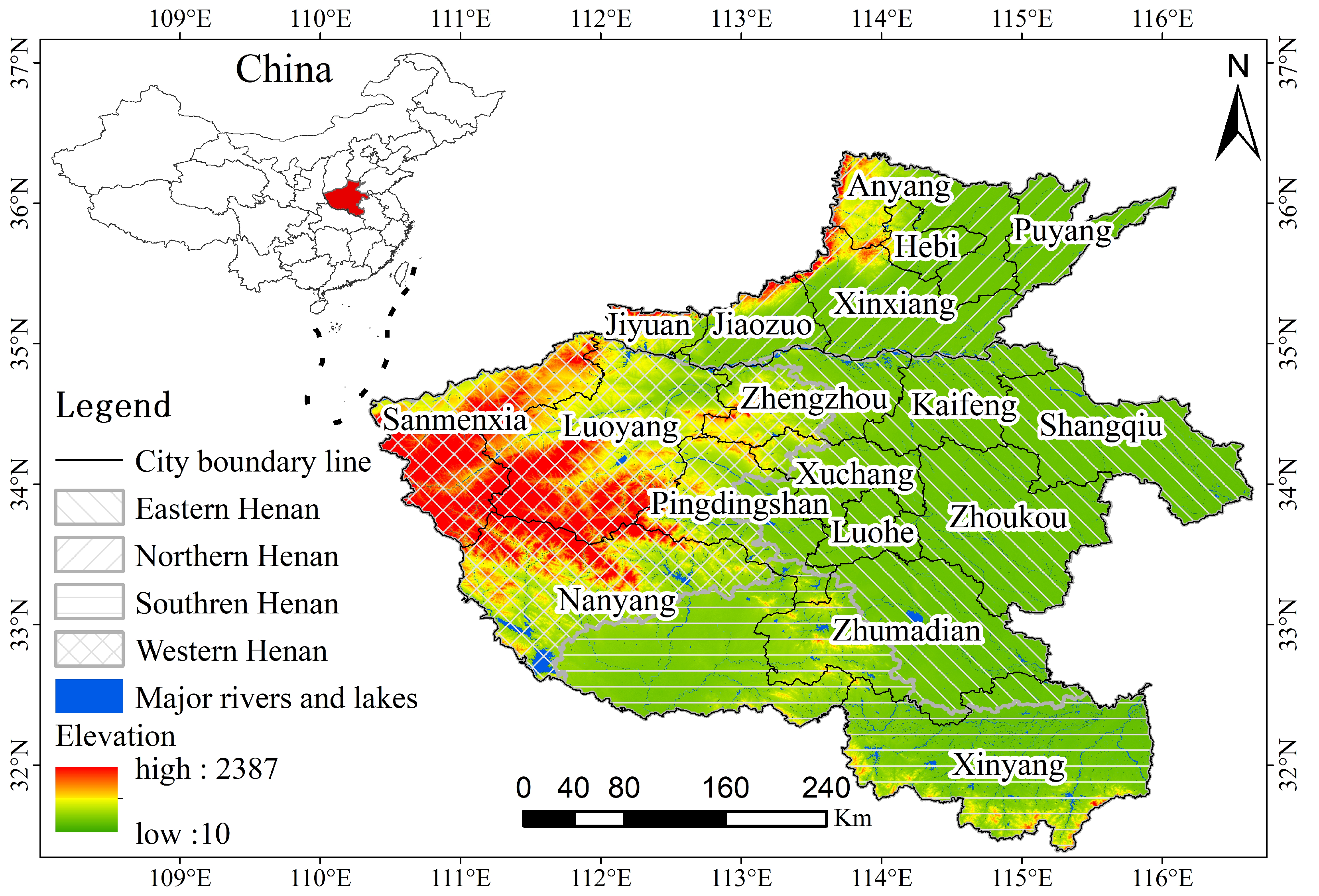
2.1. Study Area
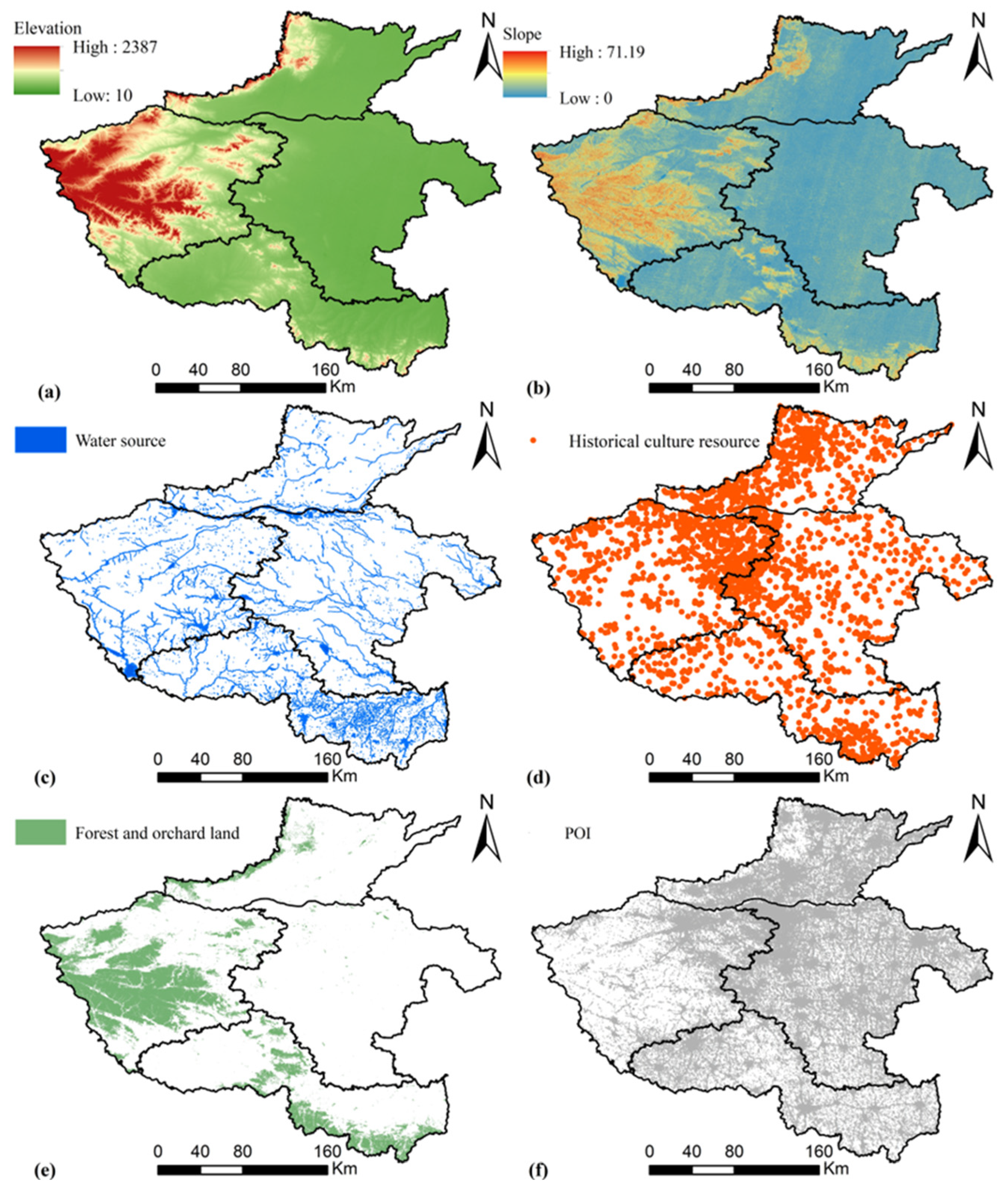
2.2. Indicator System and Data Source
2.3. Methods
2.3.1. Nearest Neighbor Index (NNI)
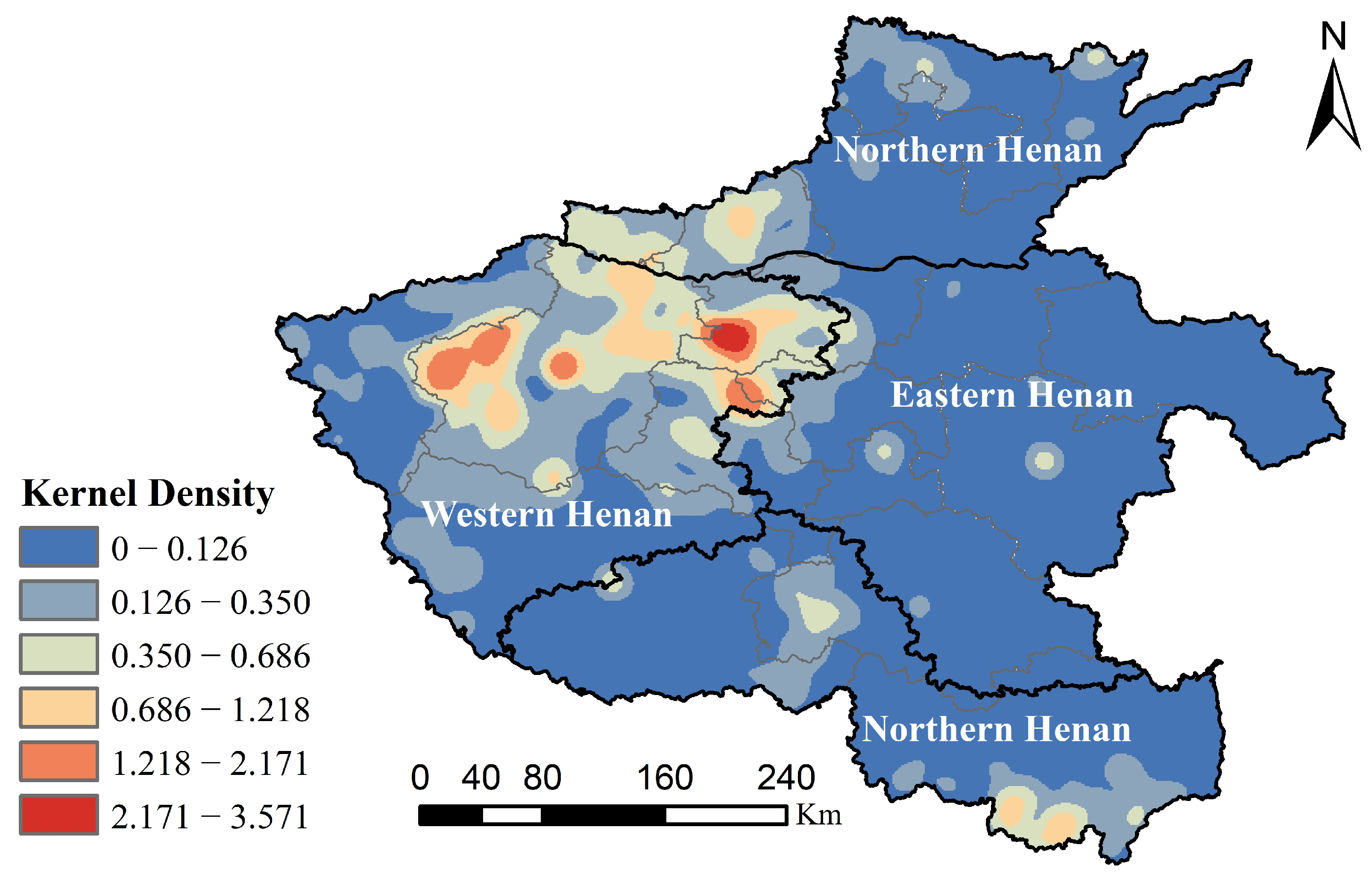
2.3.2. Kernel Density Estimation (KDE)
2.3.3. Global Moran’s I Index
2.3.4. Geographically Weighted Regression (GWR)
2.4. Study Steps
3. Results
3.1. Spatial Variation and Correlation of Ancient Trees
3.2. Influencing Mechanism Investigation
3.3. Specific Explanations of Influencing Factors
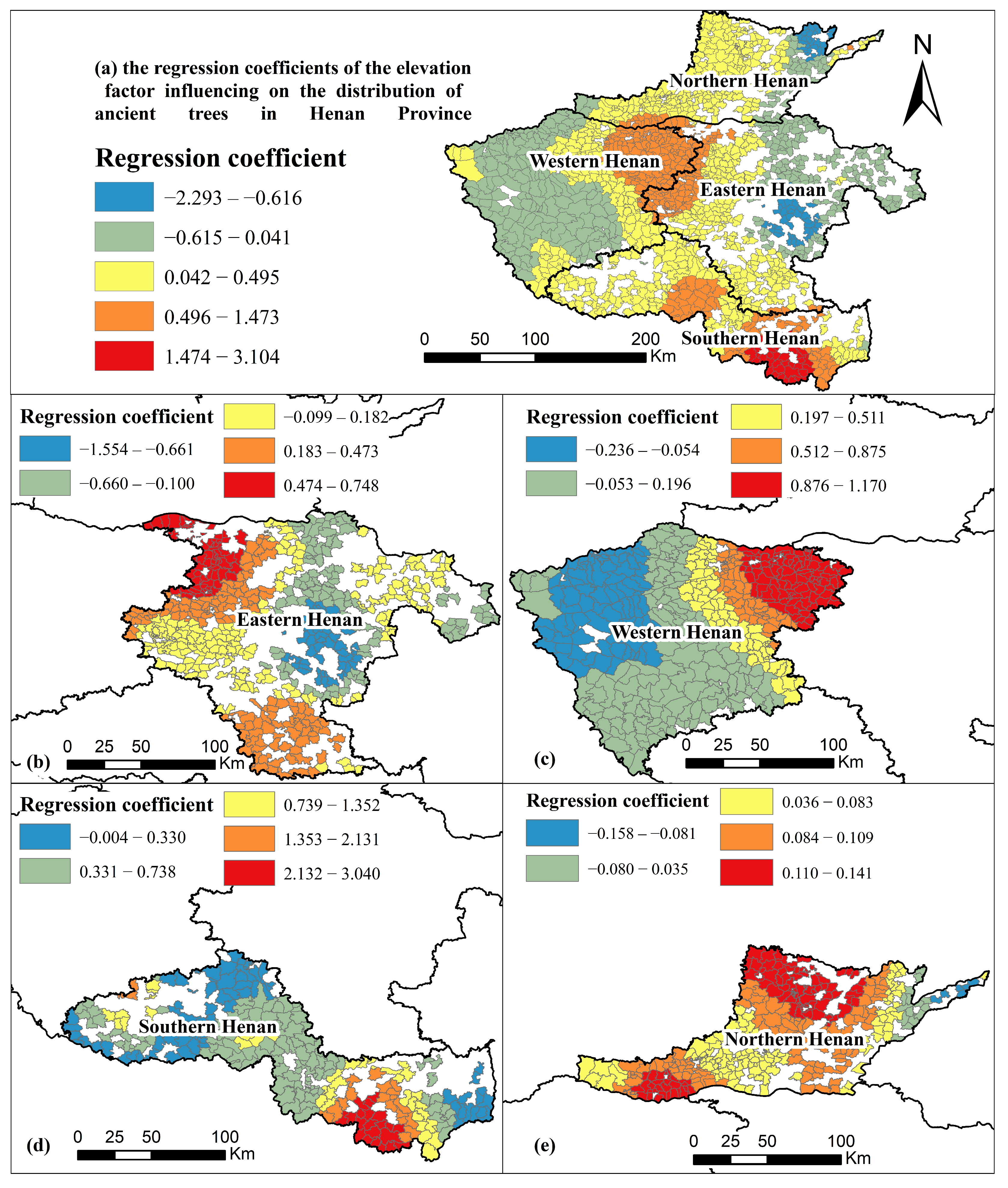
3.3.1. Elevation
3.3.2. Slope
3.3.3. Water Source
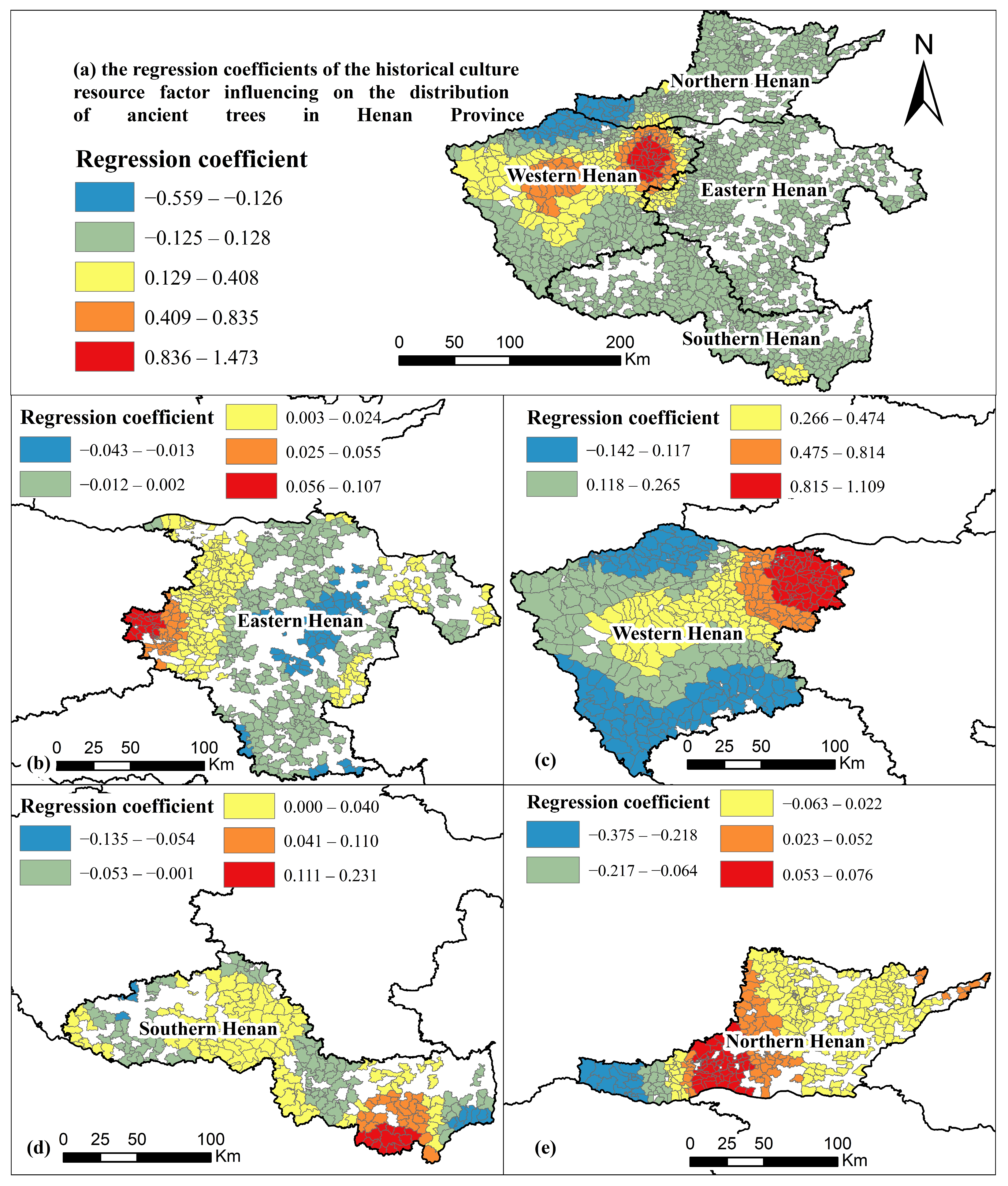
3.3.4. Historical Culture Resource
3.3.5. Growth Environment
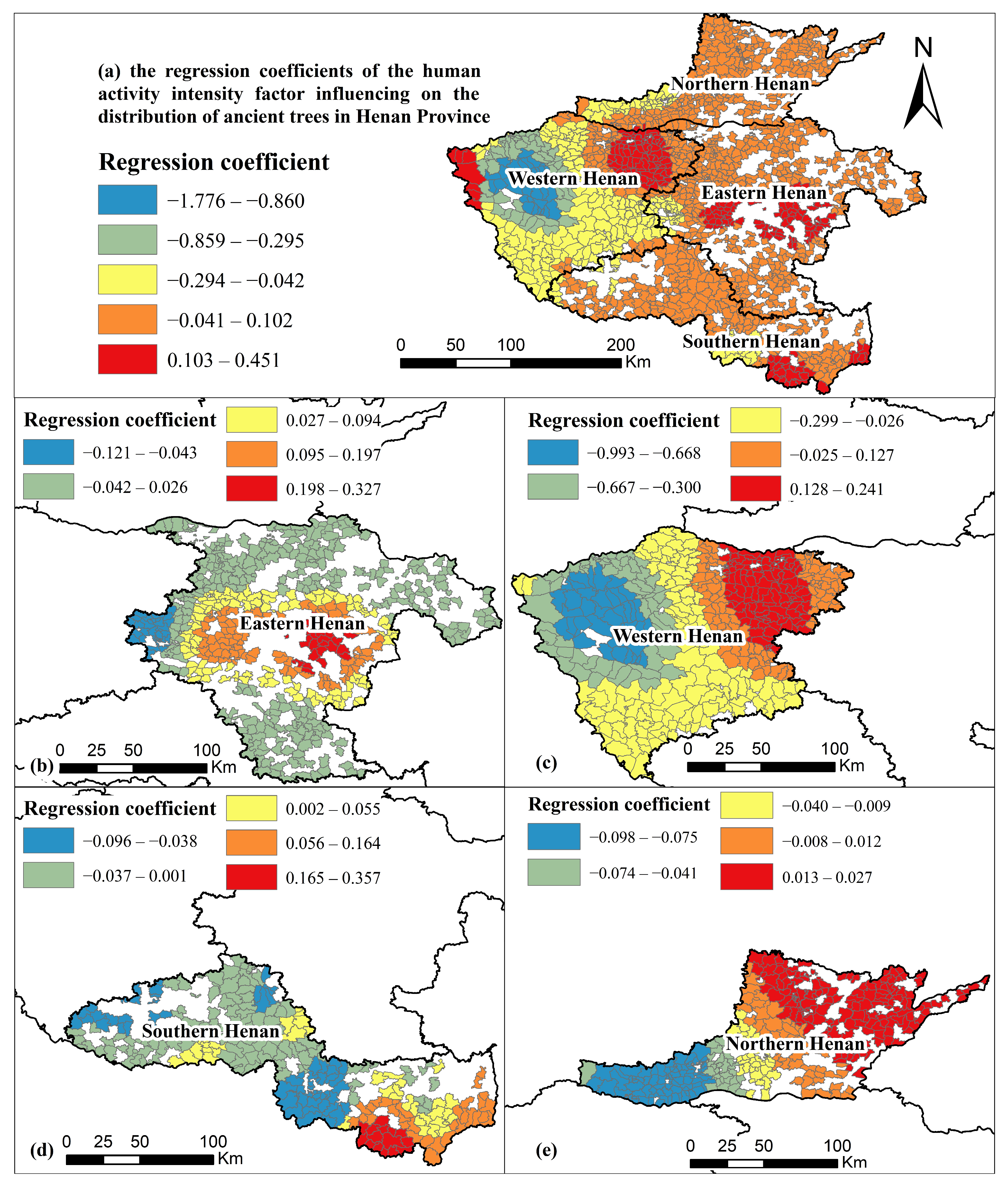
3.3.6. Human Activity Intensity
4. Discussion
4.1. Research Findings
4.2. Political Implications
4.3. Research Limitations
5. Conclusions
Author Contributions
Funding
Data Availability Statement
Acknowledgments
Conflicts of Interest
References
- Fang, C.L.; Wang, Z.B.; Liu, H.M. Beautiful China Initiative: Human-nature harmony theory, evaluation index system and application. J. Geogr. Sci. 2020, 30, 691–704. [Google Scholar] [CrossRef]
- Lu, X.; Zhang, S.J.; Xing, J.; Wang, Y.J.; Chen, W.H.; Ding, D.; Wu, Y.; Wang, S.X.; Duan, L.; Hao, J.M. Progress of Air Pollution Control in China and Its Challenges and Opportunities in the Ecological Civilization Era. Engineering 2020, 6, 1423–1431. [Google Scholar] [CrossRef]
- Liu, J.J.; Yang, B.; Lindenmayer, D.B. The oldest trees in China and where to find them. Front. Ecol. Environ. 2019, 17, 319–321. [Google Scholar] [CrossRef]
- Lindenmayer, D.B.; Laurance, W.F. The ecology, distribution, conservation and management of large old trees. Biol Rev. 2017, 92, 1434–1458. [Google Scholar] [CrossRef] [PubMed]
- Jin, C.; Zheng, M.M.; Huang, L.; Qian, S.H.; Jim, C.Y.; Lin, D.M.; Zhao, L.; Minor, J.; Coggins, C.; Chen, B.; et al. Co-existence between humans and nature: Heritage trees in China’s Yangtze River region. Urban For. Urban Green. 2020, 54, 126–748. [Google Scholar] [CrossRef]
- Piovesan, G.; Cannon, C.H.; Liu, J.J.; Munné-Bosch, S. Ancient trees: Irreplaceable conservation resource for ecosystem restoration. Trends Ecol. Evol. 2022, 37, 1025–1028. [Google Scholar] [CrossRef] [PubMed]
- Cannon, C.H.; Piovesan, G.; Munné-Bosch, S. Old and ancient trees are life history lottery winners and vital evolutionary resources for long-term adaptive capacity. Nat. Plants 2022, 8, 136–145. [Google Scholar] [CrossRef]
- Hipp, A.L.; Lazic, D. Ancient tree genomes for old questions. Mol. Ecol. 2024, 33, e17259. [Google Scholar] [CrossRef] [PubMed]
- Matthew, G.B.; Ben, P.; Sarah, J.K.F.; Josée, S.R.; Yang, Z.Q. Old-growth forests buffer climate-sensitive bird populations from warming. Divers Distrib. 2018, 24, 439–447. [Google Scholar] [CrossRef]
- Gilhen-Baker, M.; Roviello, V.; Beresford-Kroeger, D.; Roviello, R.N. Old growth forests and large old trees as critical organisms connecting ecosystems and human health. A Rev. Environ. Chem. Lett. 2022, 20, 1529–1538. [Google Scholar] [CrossRef]
- Di Matteo, G.; Luzzi, G.; Basile, A.; Sposato, A.; Bertini, G.; Neri, U.; Pennelli, B.; Napoli, R.; Nardi, P. Carbon concentrations and carbon storage capacity of three old-growth forests in the Sila National Park, Southern Italy. J. For. Res. 2023, 34, 233–242. [Google Scholar] [CrossRef]
- Zhang, S.; Cheng, X.; Wang, Z.; Cui, K.; Liao, S. The Future Potential Distribution and Sustainable Management of Ancient Pu’er Tea Trees (Camellia sinensis var. assamica (J. W. Mast.) Kitam.). Forests. 2022, 13, 983. [Google Scholar] [CrossRef]
- Martin-Benito, D.; Pederson, N.; Férriz, M.; Gea-Izquierdo, G. Old forests and old carbon: A case study on the stand dynamics and longevity of aboveground carbon. Sci. Total Environ. 2021, 765, 142737. [Google Scholar] [CrossRef] [PubMed]
- Biernacka, P.; Adamska, I.; Felisiak, K. The Potential of Ginkgo biloba as a Source of Biologically Active Compounds-A Review of the Recent Literature and Patents. Molecules 2023, 28, 3993. [Google Scholar] [CrossRef] [PubMed]
- Xie, C.; Liu, C.; Wang, H.; Liu, D.; Jim, C.Y. Distribution pattern of large old Ginkgo biloba in China under climate change scenarios. Ecol. Evol. 2024, 14, e11367. [Google Scholar] [CrossRef] [PubMed]
- Fu, Q.; Qiu, E.; Zhang, Y.; Huang, L.; Wang, H.; Jiang, S. Discussion of the Distribution Pattern and Driving Factors of 2 Large Old Tree Resources in Beijing. Forests 2022, 13, 1500. [Google Scholar] [CrossRef]
- Blicharska, M.; Mikusinski, G. Incorporating social and cultural significance of large old trees in conservation policy. Conserv. Biol. 2014, 28, 1558–1567. [Google Scholar] [CrossRef] [PubMed]
- Huang, L.; Tian, L.J.; Zhou, L.H.; Jin, C.; Qian, S.H.; Jim, C.Y.; Lin, D.M.; Zhao, L.; Minor, J.; Coggins, C.; et al. Local cultural beliefs and practices promote conservation of large old trees in an ethnic minority region in southwestern China. Urban For. Urban Green. 2020, 49, 126584. [Google Scholar] [CrossRef]
- Taynik, A.V.; Myglan, V.S.; Barinov, V.V.; Oidupaa, O.C.; Churakova (Sidorova), O.V. Ancient larch trees in the Tuva Republic, land of the oldest trees in Russia. Eco Mont J. Prot. Mt. Areas Res. 2023, 15, 13–19. [Google Scholar] [CrossRef]
- Hartel, T.; Arghiuș, V.; Stoican, F.; Réti, K.O.; Bouriaud, L. New law for old trees in Romania: Lessons and opportunities. Conserv. Sci. Pract. 2023, 5, e13032. [Google Scholar] [CrossRef]
- Stahle, D.W. Natural monuments Reverence for old trees sparked early forest conservation efforts, even as ancient woodlands were cut with impunity. Science 2022, 378, 145. [Google Scholar] [CrossRef] [PubMed]
- Lindenmayer, D.B.; Laurance, W.F.; Franklin, J.F. Global decline in large old trees. Science 2012, 338, 1305–1306. [Google Scholar] [CrossRef] [PubMed]
- Rega-Brodsky, C.C.; Aronson, M.F.; Piana, M.R.; Carpenter, E.S.; Hahs, A.K.; Herrera-Montes, A.; Knapp, S.; Kotze, D.J.; Lepczyk, C.A.; Moretti, M. Urban biodiversity: State of the science and future directions. Urban Ecosyst. 2022, 25, 1083–1096. [Google Scholar] [CrossRef]
- Lai, P.Y.; Jim, C.Y.; Tang, G.D.; Hong, W.J.; Zhang, H. Spatial differentiation of heritage trees in the rapidly-urbanizing city of Shenzhen, China. Landsc. Urban Plan. 2019, 181, 148–156. [Google Scholar] [CrossRef]
- Li, K.D.; Zhang, G.F. Species Diversity and Distribution Pattern of Heritage Trees in the Rapidly-Urbanizing Province of Jiangsu, China. Forests 2021, 12, 1543. [Google Scholar] [CrossRef]
- Nolan, V.; Gilbert, F.; Reed, T.; Reader, T. Distribution models calibrated with independent field data predict two million ancient and veteran trees in England. Ecol. Appl. 2022, 32, e2695. [Google Scholar] [CrossRef] [PubMed]
- Pelz, K.A.; Hayward, G.; Gray, A.N.; Berryman, E.M.; Woodall, C.W.; Nathanson, A.; Morgan, N.A. Quantifying old-growth forest of United States Forest Service public lands. For. Ecol. Manag. 2023, 549, 121437. [Google Scholar] [CrossRef]
- McCormick, A.C.; Sandra, I.; Andreas, B.G.; Gershenzon, J.; Köllner, T.G.; Unsicker, S.B. Herbivore-induced volatile emission from old-growth black poplar trees under field conditions. Sci. Rep. 2019, 9, 7714. [Google Scholar] [CrossRef] [PubMed]
- Ninot, A.; Howad, W.; Aranzana, M.J.; Senar, R.; Romero, A.; Mariotti, R.; Baldoni, L.; Belaj, A. Survey of over 4,500 monumental olive trees preserved on-farm in the northeast Iberian Peninsula, their genotyping and characterization. Sci. Hortic. 2018, 231, 253–264. [Google Scholar] [CrossRef]
- Zhang, Z.; Xu, Y.M.; He, Z.L.; Liu, C.X.; Wang, R.; Wang, X.N.; Peng, Y.H.; Chen, L.S.; Peng, S.F.; Ma, L.; et al. Physiological and molecular characteristics associated with the anti-senescence in Camellia oleifera Abel. Photosynthetica 2024, 62, 102–111. [Google Scholar] [CrossRef]
- Chi, X.L.; Yang, G.; Sun, K.; Li, X.L.; Wang, T.L.; Zhang, A.J.; Li, Y.; Cheng, M.; Wang, Q.G. Old ginkgo trees in China: Distribution, determinants and implications for conservation. Glob. Ecol. Conserv. 2020, 24, e01304. [Google Scholar] [CrossRef]
- Nolan, V.; Reader, T.; Gilbert, F.; Atkinson, N. The Ancient Tree Inventory: A summary of the results of a 15 year citizen science project recording ancient, veteran and notable trees across the UK. Biodivers. Conserv. 2020, 29, 3103–3129. [Google Scholar] [CrossRef]
- Izadi, S.; Sohrabi, H.; Khaledi, M.J. Estimation of coppice forest characteristics using spatial and non-spatial models and Landsat data. J. Spat. Sci. 2022, 67, 143–156. [Google Scholar] [CrossRef]
- Wang, J.Y.; Du, H.Q.; Li, X.J.; Mao, F.J.; Zhang, M.; Liu, E.B.; Ji, J.Y.; Kang, F.F. Remote Sensing Estimation of Bamboo Forest Aboveground Biomass Based on Geographically Weighted Regression. Remote Sens. 2021, 13, 2962. [Google Scholar] [CrossRef]
- Park, J.; Choi, B.; Lee, J. Spatial Distribution Characteristics of Species Diversity Using Geographically Weighted Regression Model. Sens. Mater. 2019, 31, 3197–3213. [Google Scholar] [CrossRef]
- Zhang, L.J.; Bi, H.Q.; Cheng, P.F.; Davis, C.J. Modeling spatial variation in tree diameter-height relationships. For. Ecol. Manag. 2004, 189, 317–329. [Google Scholar] [CrossRef]
- Huang, L.; Jin, C.; Zhen, M.M.; Zhou, L.H.; Qian, S.H.; Jim, C.Y.; Lin, D.M.; Zhao, L.; Minor, J.; Coggins, C.; et al. Biogeographic and anthropogenic factors shaping the distribution and species assemblage of heritage trees in China. Urban For. Urban Green. 2020, 50, 126652. [Google Scholar] [CrossRef]
- Xie, C.; Li, M.; Jim, C.Y.; Liu, D. Environmental Factors Driving the Spatial Distribution Pattern of Venerable Trees in Sichuan Province, China. Plants 2022, 11, 3581. [Google Scholar] [CrossRef] [PubMed]
- Benner, J.; Nielsen, J.; Lertzman, K. Using Traditional Ecological Knowledge to Understand the Diversity and Abundance of Culturally Important Trees. J. Ethnobiol. 2021, 41, 209–228. [Google Scholar] [CrossRef]
- Lu, B.B.; Brunsdon, C.; Charlton, M.; Harris, P. Geographically weighted regression with parameter-specific distance metrics. Int. J. Geogr. Inf. Sci. 2017, 31, 982–998. [Google Scholar] [CrossRef]
- Cui, J.; Qureshi, S.; Harris, A.J.; Jim, C.Y.; Wang, H. Venerable trees of tropical Chinese Wuzhishan city: Distribution patterns and drivers. Urban Ecosyst. 2022, 25, 1765–1776. [Google Scholar] [CrossRef]
- Suchocka, M.; Wojnowska-Heciak, M.; Błaszczyk, M.; Gawłowska, A.; Ciemniewska, J.; Jarska, A.; Heciak, J.; Pachnowska, B. Old trees are perceived as a valuable element of the municipal forest landscape. PeerJ 2022, 10, e12700. [Google Scholar] [CrossRef] [PubMed]
- Yang, Z.H.; Bai, J.W.; Zhang, W.W. Mapping and assessment of wetland conditions by using remote sensing images and POI data. Ecol. Indic. 2021, 127, 107485. [Google Scholar] [CrossRef]
- Wang, Y.; Huang, H.; Yang, G.; Chen, W. Ecosystem Service Function Supply–Demand Evaluation of Urban Functional Green Space Based on Multi-Source Data Fusion. Remote Sens. 2023, 15, 118. [Google Scholar] [CrossRef]
- Kint, V.; van Meirvenne, M.; Nachtergale, L.; Geudens, G.; Lust, N. Spatial methods for quantifying forest stand structure development: A comparison between nearest-neighbor indices and variogram analysis. For. Sci. 2003, 49, 36–49. [Google Scholar] [CrossRef]
- Huang, J.; Lu, H.; Jin, H.; Zhang, L. Urban resilience in China’s eight urban agglomerations: Evolution trends and driving factors. Environ. Sci. Pollut. Res. 2023. [Google Scholar] [CrossRef] [PubMed]
- Bivand, R.; Müller, W.G.; Reder, M. Power calculations for global and local Moran’s l. Comput. Stat. Data Anal. 2009, 53, 2859–2872. [Google Scholar] [CrossRef]
- Zhu, C.M.; Zhang, X.L.; Zhou, M.M.; He, S.; Gan, M.Y.; Yang, L.X.; Wang, K. Impacts of urbanization and landscape pattern on habitat quality using OLS and GWR models in Hangzhou, China. Ecol. Indic. 2020, 117, 106654. [Google Scholar] [CrossRef]
- Zhou, Y.S.; Jiang, Z.J. Investigation and Analysis of Ancient and Famous Tree Resources in Henan Province. J. Green Sci. Technol. 2021, 23, 129–132. [Google Scholar]
- Lindenmayer, D.B.; Blanchard, W.; Blair, D.; McBurney, L.; Banks, S.C. Environmental and human drivers influencing large old tree abundance in Australian wet forests. For. Ecol. Manag. 2016, 372, 226–235. [Google Scholar] [CrossRef]
- Wan, J.Z.; Li, Q.F.; Wei, G.L.; Yin, G.J.; Wei, D.X.; Song, Z.M.; Wang, C.J. The effects of the human footprint and soil properties on the habitat suitability of large old trees in alpine urban and periurban areas. Urban For. Urban Green. 2020, 47, 126–520. [Google Scholar] [CrossRef]


| Category | Influencing Factor | Quantification Standard |
|---|---|---|
| Natural factors | Elevation | The average altitude of the town (m) |
| Slope | The average slope of the town (°) | |
| Water source | The shortest distance to the nearest water source (m) × (−1) | |
| Human factors | Historical culture resource | The shortest distance to the nearest historical and cultural resource spot (m) × (−1) |
| Growing environment | The ratio of forest and orchard land area to the township area (%) | |
| Human activity intensity | The number of POIs |
| Influencing Factor | Mean | Std | Min | Max |
|---|---|---|---|---|
| Elevation (m) | 191.108 | 213.080 | 22.667 | 1597.673 |
| Slope (°) | 6.210 | 3.708 | 0.000 | 32.959 |
| Water source (m) | 3258.215 | 2481.613 | 0.000 | 17,708.922 |
| Historical culture resource (m) | 4348.136 | 3016.399 | 48.035 | 26,328.819 |
| Growing environment (%) | 10.524 | 22.350 | 0.000 | 99.951 |
| Human activity intensity | 1359.943 | 1969.069 | 0.000 | 25,248.000 |
| Influencing Factor | Henan Province | Eastern Henan | Western Henan | Southern Henan | Northern Henan |
|---|---|---|---|---|---|
| Elevation | 1.881 | 1.048 | 2.089 | 1.339 | 1.658 |
| Slope | 2.327 | 1.210 | 2.550 | 1.591 | 2.578 |
| Water source | 1.009 | 1.028 | 1.206 | 1.091 | 1.010 |
| Historical culture | 1.093 | 1.187 | 1.383 | 1.148 | 1.079 |
| Growing environment | 1.695 | 1.072 | 1.789 | 1.476 | 1.967 |
| Human activity intensity | 1.059 | 1.075 | 1.085 | 1.033 | 1.058 |
| Region | Indicator | GWR | OLS |
|---|---|---|---|
| Henan Province | AICc | −4076.436 | −3763.840 |
| R2 | 0.525 | 0.189 | |
| R2 Adjusted | 0.405 | 0.186 | |
| Northern Henan | AICc | −1417.151 | −1301.154 |
| R2 | 0.553 | 0.313 | |
| R2 Adjusted | 0.511 | 0.302 | |
| Western Henan | AICc | −577.457 | −532.820 |
| R2 | 0.302 | 0.068 | |
| R2 Adjusted | 0.197 | 0.055 | |
| Southern Henan | AICc | −968.510 | −880.280 |
| R2 | 0.715 | 0.328 | |
| R2 Adjusted | 0.601 | 0.313 | |
| Eastern Henan | AICc | −2797.614 | −2748.854 |
| R2 | 0.452 | 0.133 | |
| R2 Adjusted | 0.298 | 0.123 |
| Regions | Factors | Min | Median | Max | Mean | Std |
|---|---|---|---|---|---|---|
| Henan | Elevation | −2.293 | 0.183 | 3.104 | 0.238 | 0.551 |
| Slope | −0.453 | 0.004 | 0.806 | 0.019 | 0.161 | |
| Water source | −0.157 | 0.005 | 0.840 | 0.013 | 0.074 | |
| Historical culture | −0.559 | 0.010 | 1.473 | 0.082 | 0.221 | |
| Growing environment | −6.309 | 0.096 | 24.642 | 0.323 | 1.741 | |
| Human activity intensity | −1.776 | 0.011 | 0.451 | −0.019 | 0.217 | |
| Eastern Henan | Elevation | −1.554 | 0.084 | 0.748 | 0.042 | 0.444 |
| Slope | −0.071 | 0.002 | 0.093 | 0.000 | 0.030 | |
| Water source | −0.046 | 0.001 | 0.083 | 0.002 | 0.022 | |
| Historical culture | −0.043 | 0.001 | 0.107 | 0.004 | 0.021 | |
| Growing environment | −6.355 | 0.199 | 31.444 | 1.028 | 3.222 | |
| Human activity intensity | −0.121 | 0.013 | 0.327 | 0.039 | 0.078 | |
| Western Henan | Elevation | −0.236 | 0.208 | 1.170 | 0.363 | 0.455 |
| Slope | −0.346 | 0.084 | 0.487 | 0.065 | 0.230 | |
| Water source | −0.202 | 0.038 | 0.174 | 0.022 | 0.079 | |
| Historical culture | −0.142 | 0.260 | 1.109 | 0.356 | 0.324 | |
| Growing environment | −0.172 | 0.093 | 0.735 | 0.083 | 0.158 | |
| Human activity intensity | −0.993 | −0.036 | 0.241 | −0.106 | 0.308 | |
| Southern Henan | Elevation | −0.004 | 0.540 | 3.040 | 0.771 | 0.708 |
| Slope | −0.145 | 0.011 | 0.446 | 0.006 | 0.070 | |
| Water source | −0.123 | 0.028 | 0.795 | 0.058 | 0.137 | |
| Historical culture | −0.135 | 0.005 | 0.231 | 0.012 | 0.049 | |
| Growing environment | −2.606 | 0.069 | 14.385 | 0.339 | 1.839 | |
| Human activity intensity | −0.096 | −0.016 | 0.357 | 0.008 | 0.079 | |
| Northern Henan | Elevation | −0.158 | 0.089 | 0.141 | 0.087 | 0.041 |
| Slope | −0.032 | 0.001 | 0.190 | 0.005 | 0.028 | |
| Water source | −0.039 | 0.005 | 0.103 | 0.001 | 0.020 | |
| Historical culture | −0.375 | 0.015 | 0.076 | 0.001 | 0.081 | |
| Growing environment | −0.432 | 0.063 | 0.591 | 0.133 | 0.204 | |
| Human activity intensity | −0.098 | 0.005 | 0.027 | −0.018 | 0.045 |
Disclaimer/Publisher’s Note: The statements, opinions and data contained in all publications are solely those of the individual author(s) and contributor(s) and not of MDPI and/or the editor(s). MDPI and/or the editor(s) disclaim responsibility for any injury to people or property resulting from any ideas, methods, instructions or products referred to in the content. |
© 2024 by the authors. Licensee MDPI, Basel, Switzerland. This article is an open access article distributed under the terms and conditions of the Creative Commons Attribution (CC BY) license (https://creativecommons.org/licenses/by/4.0/).
Share and Cite
Hou, H.; Ren, W.; Wang, Z.; He, J.; Liu, B.; Jing, Y. What Drives the Spatial Variation of Interregional Ancient Trees? A Geoinformatics–Based Approach in Henan, Central China. Forests 2024, 15, 1010. https://doi.org/10.3390/f15061010
Hou H, Ren W, Wang Z, He J, Liu B, Jing Y. What Drives the Spatial Variation of Interregional Ancient Trees? A Geoinformatics–Based Approach in Henan, Central China. Forests. 2024; 15(6):1010. https://doi.org/10.3390/f15061010
Chicago/Turabian StyleHou, Heping, Wanqian Ren, Zexin Wang, Jing He, Binghui Liu, and Ying Jing. 2024. "What Drives the Spatial Variation of Interregional Ancient Trees? A Geoinformatics–Based Approach in Henan, Central China" Forests 15, no. 6: 1010. https://doi.org/10.3390/f15061010