Article

Research on a Vehicle-Mounted Emergency Communication System Using BeiDou Regional Short Message Communication (RSMC) for Firefighting Operations in Forest Areas without a Public Network

1
College of Mechanical and Electrical Engineering, Northeast Forestry University, Harbin 150040, China
2
School of Civil Engineering and Transportation, Northeast Forestry University, Harbin 150040, China
*
Author to whom correspondence should be addressed.
Forests 2024, 15(7), 1185; https://doi.org/10.3390/f15071185
Submission received: 27 May 2024 / Revised: 3 July 2024 / Accepted: 8 July 2024 / Published: 9 July 2024
(This article belongs to the Special Issue Wildfire Monitoring and Risk Management in Forests)

Abstract

:
The low coverage of public networks in pristine forest areas prevents on-site firefighters from communicating directly with remote command centers during forest fires, reducing firefighting efficiency. In this study, we designed a vehicle-mounted emergency communication system Using BeiDou RSMC (Regional Short Message Communication) for firefighting operations in forest areas without a public network to establish a satellite communication network and Zigbee self-organizing network technology to establish a local self-organizing network. Beidou RSMC is a satellite communication service developed and operated independently by China, and its signals now cover the entire globe. The combination of these two components ensures emergency communication in the event of a fire in a forest area without public network coverage. The performance of the system was tested by simulating a fire, and it was able to establish a reliable communication link between the firefighters on the scene and the remote command center in the absence of a public network. The proposed system solves the emergency communication problem that arises when a fire occurs in a forest area without a public network, enabling the remote command center to monitor fire information and dispatch various resources in real time, thereby improving firefighting efficiency and reducing casualties.

1. Introduction

Forest fires are destructive and difficult to fight, and they are among the most frequent and harmful natural disasters around the world [1,2,3]. Although China’s forest firefighting work has accomplished remarkable achievements, and the capacity to prevent and control forest fires has been effectively improved, there are insufficient resources for public network signal base stations in forest areas, and most primitive forest areas are still not covered by any network [4,5]. Enhancing secure emergency communication capacity during forest fires is essential to realize forest firefighting information sharing, improve the efficiency of firefighting, and reduce casualties among firefighting personnel [6,7,8].
The United States, Canada, and other countries have conducted research on forest fire emergency communications, and some of the theories they proposed have been continuously verified [9,10]. For example, the new generation of the forest fire monitoring system, developed by the United States Department of Agriculture Forest Service and NASA, utilizes satellite remote sensing data such as the Moderate Resolution Imaging Spectroradiometer (MODIS) and the visible infrared imaging radiometer to monitor surface temperature anomalies in real time and identify the location and intensity of fires, and provides data support for the management of protected areas and prevention and control of forest fires globally [11]. China is also actively exploring and building an emergency communication system for fighting forest fires [11,12]. Examples include the SatSee satellite fire watching system, provided by the Institute of Remote Sensing and Digital Earth of the Chinese Academy of Sciences [13]; the GEOVIS forest fire monitoring system, developed by CSTAR, based on the GEOVIS digital earth foundation platform [14]; and an integrated sky and earth forest fire monitoring system, provided by the Territorial Satellite Remote Sensing Application Center of the Ministry of Natural Resources. Each system utilizes different satellite remote sensing data and technical means to provide scientific methods and tools for early warning, monitoring, assessment, and management of forest fires [12,14].
Experts and scholars from all over the world have also conducted studies on emergency communication in case of fire in ungazetted forest areas. McClure et al. designed a fire mapping methodology that uses next-day active fire and thermal anomaly satellite retrievals to develop a high-resolution wildfire growth dataset, which led to important advances in fire behavior and fire weather research, as well as model development efforts, smoke modeling, and near-real-time fire monitoring [15]. Parkbeomsun et al. established a geostationary satellite system for 24 h monitoring of forest fires in the Korean Peninsula, with ground stations processing the data received from satellites to analyze the monitoring data [16]. Kim et al. designed a new conceptual framework for disaster monitoring and proposed a viable disaster monitoring system that relies heavily on accessible satellite data [17]. Sun et al. proposed four special requirements for satellite disaster monitoring: multi-band area, three-dimensional request, fixed angle request, and real-time download request [18]. Dvorkin et al. presented a methodology for GNSS radio-navigation field parameter monitoring and integrity assessment that uses a monitoring system that facilitates differential correction of satellites [19].
Several scholars in China began to discuss the application of remote sensing satellites a long time ago and provided ideas for satellite communications to be applied in forest fires [20]. Li et al. designed a forest fire monitoring system based on satellite data, which divides the time sequence of fire point identification from fuzzy to definite in three steps, allowing forest fire information to be processed at the same time as the satellite transit and overcoming the problem of the current meteorological satellite forest fire monitoring system being unable to monitor in real time [21]. Deng et al. proposed a star–earth converged communication network architecture for forest fire emergency communication and constructed a linked multi-level information interaction network of “fire field–mobile front finger–command center” [22]. Bo et al. combined the functional tasks of urban firefighting and rescue teams with typical forest fire cases to construct an integrated air–earth–ground satellite–unmanned aerial vehicle–ground communication system, which ensures the real-time capability of communication services, including voice, positioning, and image [23]. Wu et al. analyzed the application of BeiDou terminals in forest fire early warning monitoring and described the application of the BeiDou system in a county (district) level forest fire precision monitoring technology system [24].
Aiming to solve the problem of being unable to communicate with the outside world during firefighting operations in forests due to the absence of public network coverage in large forest areas, in this study, we designed a vehicle-mounted emergency communication system using BeiDou RSMC, which consists of two parts: a local self-organized network terminal and a satellite communication network terminal. This system is intended to solve the emergency communication problem when a fire occurs in forest areas without a public network by allowing for a reliable communication link to be established between on-site firefighters and a remote command center.
In Section 2.3, the team tested the system at the Experimental Forestry Farm of Maoer Mountain, Harbin City, Heilongjiang Province. The experiment simulated the whole process of a fire from onset to extinguishing, and a firetruck equipped with the vehicle-mounted emergency communication system completed the firefighting operation. At the end of the experiment, the reliability of the system was analyzed. However, a major shortcoming in this study was the lack of different types of geographic locations in the testing environment. Testing in only a single type of geographic environment may limit the broad applicability of the results, thus affecting the overall assessment of the system’s performance under various environmental conditions in real-world applications. In future work, we will test the system with a richer set of geographic location variables.

2. Materials and Methods

This section details the comprehensive framework and methodology employed in this study. It is divided into four main parts. First, we describe the system design, outlining the architecture and specific design considerations for local self-organizing network terminals and satellite communication network terminals. Next, we cover the experimental setup, detailing the equipment and configurations used to test the system. Following this, the experimental procedure is described, providing a step-by-step account of how the experiments were conducted. Finally, we present the data statistics methods used to analyze the collected data, ensuring the reliability and validity of the results.

2.1. System Design

In this section, we present a comprehensive overview of the system design, focusing on three key components. Firstly, we discuss the overall system architecture, detailing the fundamental structure and interconnections between different subsystems. Secondly, we delve into the design of local self-organizing network terminals, highlighting their role in establishing robust and resilient communication within a defined local area. Finally, we examine the design of satellite communication network terminals, which ensure long-distance connectivity and seamless integration with broader communication networks. Each subsection addresses specific design considerations and technical specifications crucial for the effective functioning of the overall system.

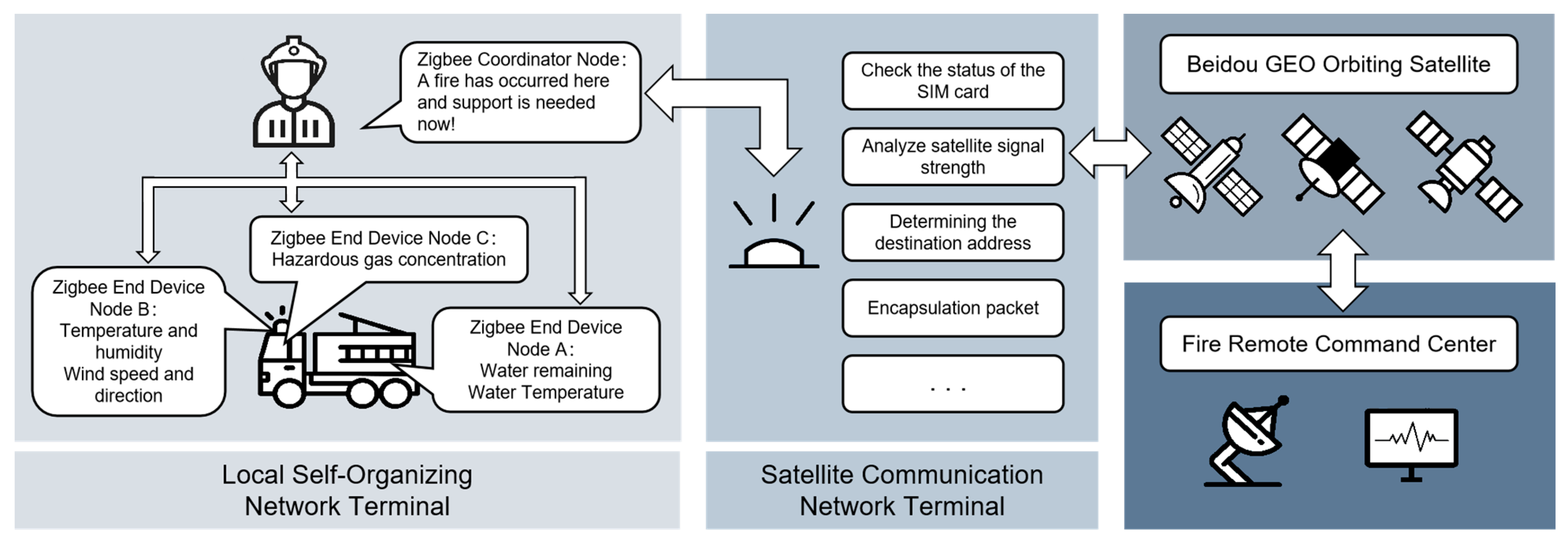
2.1.1. System Architecture

In the application environment of fires occurring in primitive forest areas without a public network, we built a BeiDou satellite communication network based on Radio Determination Satellite Service (RDSS) protocol to establish communication with a remote command center [25,26,27]. Considering the urgency of firefighting operations and the need for firefighters to act immediately upon entering the scene, a local self-organized network is established by using Zigbee self-organized network technology based on the IEEE 802.15.4 [28] protocol [29,30]. By utilizing this method, a reliable emergency communication network can be constructed at the fire scene quickly.
In this study, the local self-organized network terminal and satellite communication network terminal are designed based on BeiDou RDSS technology. The local self-organizing network terminal can automatically collect various kinds of parameter information of the fire field and summarize this information and the user’s freely edited information for the local equipment through the Zigbee wireless self-organizing network, and then wait for the next transmission from the satellite communication network terminal. The satellite communication network terminal then packages and sends the aggregated data to the BeiDou GEO orbiting satellite, thus establishing two-way communication with the remote command center when there is no public network [31,32]. Figure 1 shows the system architecture.

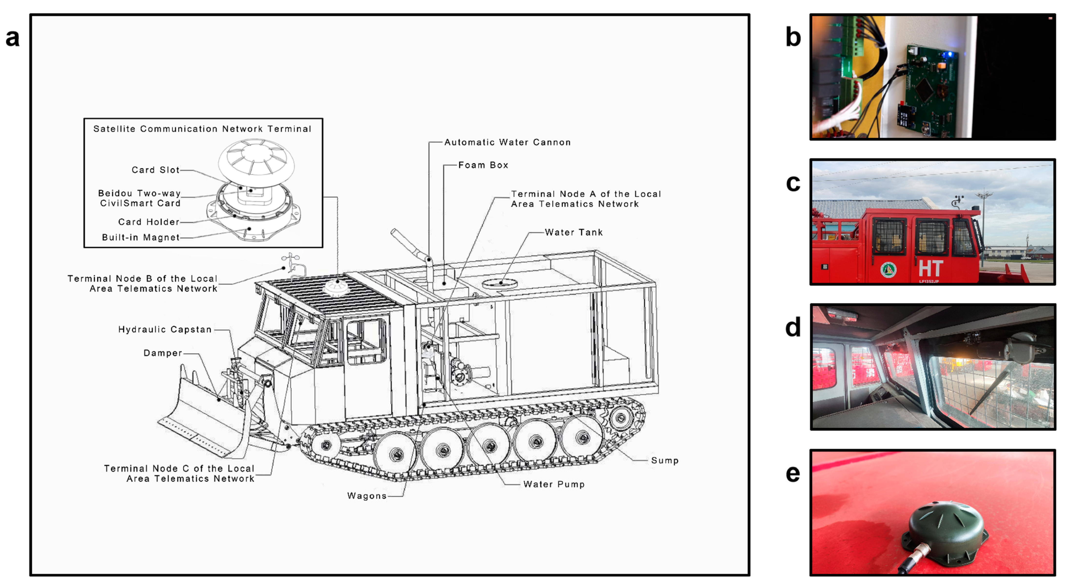
2.1.2. Design of Local Self-Organizing Network Terminals

Considering the urgency of the firefighting operation, the on-site firefighters need to go into action immediately once they enter the scene. Aggregating all the data using appropriate wireless communication technology before proceeding with satellite communications can greatly enhance efficiency. Table 1 lists some of the major wireless communication technologies that do not rely on cellular networks and their characteristics.
Zigbee technology shows obvious advantages after considering the special needs of forest firefighting vehicle-mounted wireless communication networks. The low power consumption of forest firefighting vehicles, which may operate for tens of hours at a time, allows them to maintain communication networks for long periods of time.
The self-organizing nature makes them particularly suitable for emergency firefighting operations. If a link fails and does not work, the operator does not have to spend extra time dealing with the problem; it will adjust its topology and find another suitable link on its own.
In addition, the communication range of individual Zigbee devices is generally between 10 m and 30 m, while the distance of the parameter collection nodes with forest fire trucks as carriers is no more than 10 m, so the range of the Zigbee network link can meet the requirements of local area wireless network. From the outside, through the relay function of Zigbee devices and optimized layout, its coverage can be further extended.
Therefore, the system is based on the Zigbee networking technology IEEE 802.15.4 protocol to establish a local self-organizing network. The Zigbee self-organizing network technology can quickly build a reliable emergency communication network at the fire scene. The system uses channels in the 2.4 GHz band, and the ideal data transmission rate in this band is 250 Kb/s in the physical layer. The topology of the local self-organizing network is a tree structure, consisting of three end device nodes and one coordinator node. Figure 2a shows the distribution of Zigbee channels over the 2.4 GHz band. Figure 2b shows the four-layer structure of the Zigbee protocol stack. Figure 2c shows the logical structure between nodes of local self-organizing network.
Each node uses a TI CC2530 as the main controller, which, as a system-on-chip (SOC) for 2.4 GHz IEEE 802.15.4, Zigbee, and RF4CE, combines the performance of an RF transceiver, an industry-standard enhanced 8051 CPU, in-system programmable flash memory and 8 KB RAM, and many other powerful features [33,34]. Meanwhile, the CC2530 incorporates the Zigbee protocol stack (Z-Stack™). The Z-StackTM was proposed by the Connectivity Standards Consortium and is based on the IEEE 802.15.4 standard, which provides a powerful and complete solution for building local self-organizing networks [35,36,37]. Table 2 shows the types of sensors connected to each node and the parameters monitored.

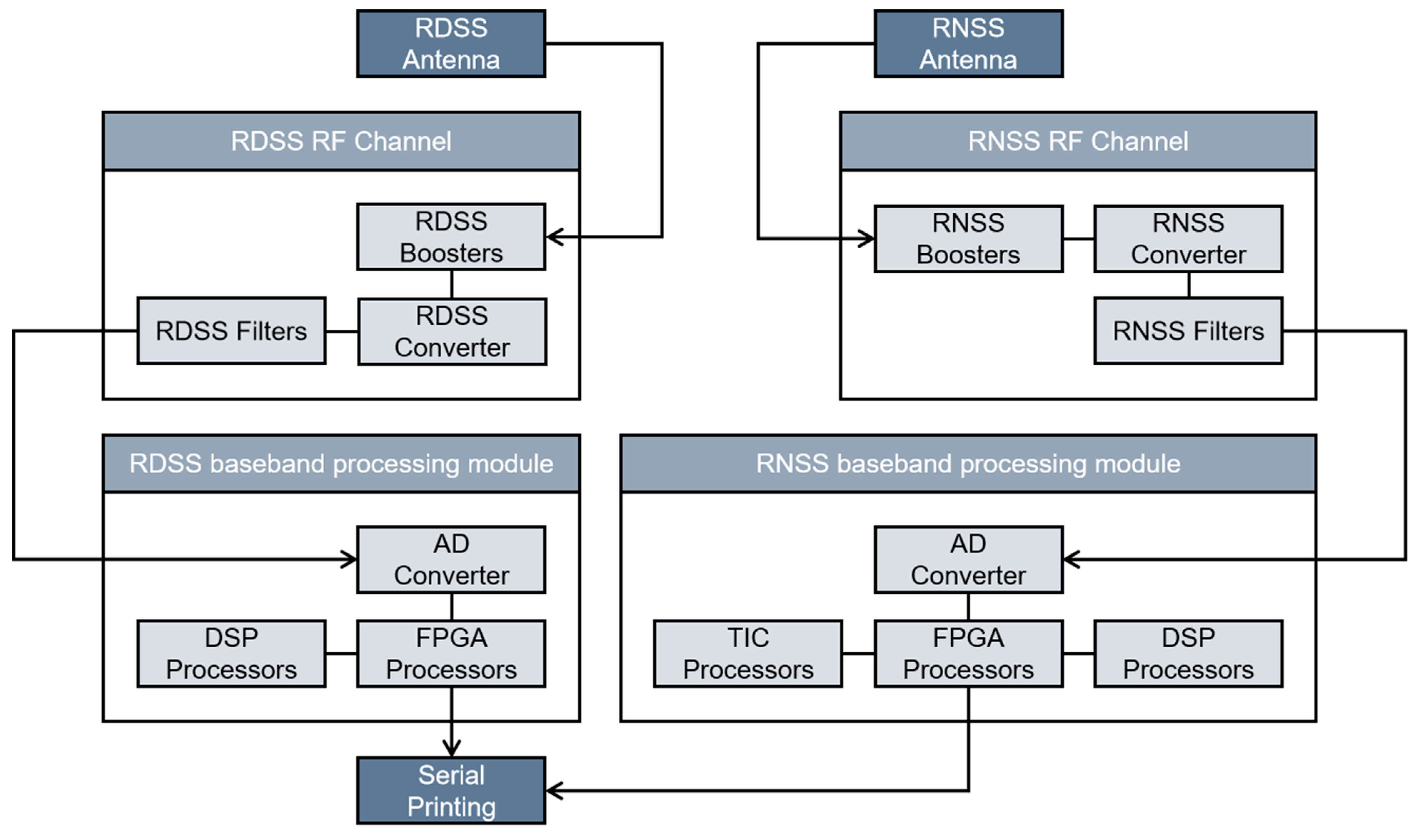
2.1.3. Design of Satellite Communication Network Terminals

The satellite communication network terminal integrates BeiDou multi-frequency antenna, radio frequency, baseband, and master control and other functional units, which can realize self-test and initialization, short-message communication, satellite precision timing, and other functions. Each BeiDou satellite short message is categorized into either a RSMC or a global short message (GSMC), and short messages are coded by using mixed coding or code coding mode [14,38].
The RSMC service used in this system utilizes the GEO satellite to provide RSMC to users in China and the surrounding areas, using mixed codes to encode the RSMC to be sent. Statements begin with the statement start delimiter $ and end with the statement terminator <CR> <LF>.
The BeiDou satellite navigation system integrates the Regional Navigation Satellite System (RNSS) and RDSS, i.e., both RNSS and RDSS services are integrated in the navigation satellites of the system as well as the operation and control of the system [39,40]. The positioning service provided by the BeiDou RDSS system is active, with positioning accuracy of 100 m, whereas the positioning provided by the RNSS system is passive, with positioning accuracy of within 5 m. Therefore, this system adopts the short-message communication service provided by the BeiDou RDSS system and the positioning service provided by the BeiDou RNSS system. Figure 3 shows the signal processing flow of the satellite communication network terminal.

2.2. Experimental Setup

In October 2023, an experiment with the vehicle-mounted emergency communication system using BeiDou RSMC for firefighting in forest areas without a public network was carried out at the Experimental Forestry Farm of Maoer Mountain, Harbin City, Heilongjiang Province. The experiment simulated the whole process of a fire from onset to extinguishing, and a firetruck equipped with the vehicle-mounted emergency communication system completed the firefighting operation. At the end of the experiment, the reliability of the system was analyzed.
The LF1352JP tracked firefighting vehicle was used for the experiment. The vehicle was manufactured by Songjiang Tractor Co. in Harbin, China, and consists of a power system, a crawler chassis, a control system, an obstacle removal device, a hydraulic winch, a water cannon and water tank, and other equipment [41]. The LF1352JP has the functions of firefighting, transporting feed, winching for self-rescue and other rescues, etc. It is one of most commonly used firetrucks for forest fires in northeastern and northern China [42].
The experiment uses the BeiDou-2 two-way civil smart card. Different user categories of this smart card have different definitions for registering service frequency ranges and communication levels [43]. In the practical application scenario of this system, the personnel at the remote command center observe the data trends and determine further actions of the firefighting operation based on the transmitted data information, and this process accounts for more than 90% of a complete work cycle. Therefore, the BeiDou-2 two-way civil smart card, with a service frequency of 60 s/time and a message length of 848 bit/article, was selected for testing in this experiment.
The smart card was installed in the card slot of the satellite communication network terminal, and the vehicle-mounted emergency communication system using BeiDou RSMC for fighting fires in forest areas without a public network was installed on each part of the LF1352JP firetruck, and its assembly structure is shown in Figure 4a.
Role A is classified as the firefighting site operator and Role B is the remote command center operator. The LF1352JP crawler-type firetruck is equipped with a local self-organizing network terminal and a satellite communication network terminal; the nodes of the local terminal are mounted to each part of the firetruck (Figure 4b–d), and the satellite terminal is mounted to the top of the driver’s cab (Figure 4e).

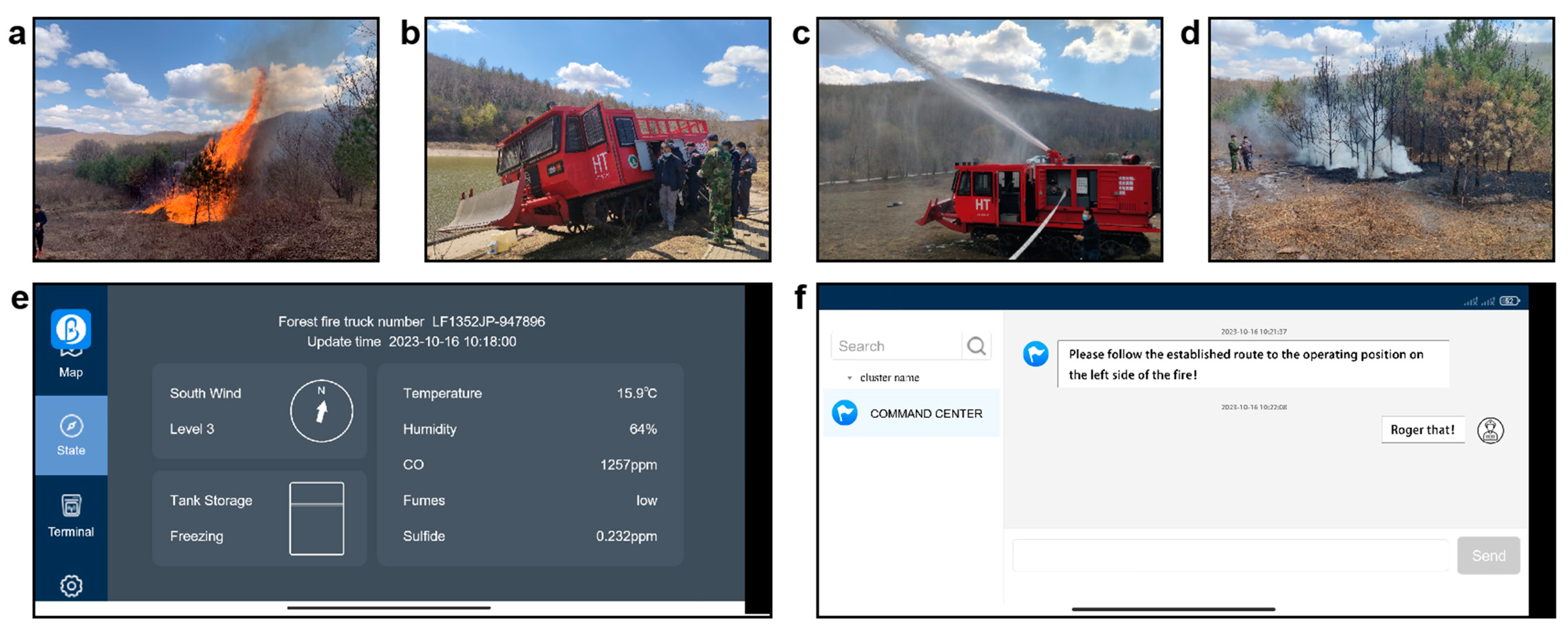
2.3. Experimental Procedure

In the experiment, the following scenario is simulated:
(1)
When the fire breaks out (Figure 5a), Role B monitors the location of the fire through remote sensing satellite imagery at 45°22′ N, 127°30′ E;
(2)
Actor B sends the fire location and firefighting instructions to Actor A through the system, and A drives the forest fire truck to the fire scene according to the instructions (there is no ground network signal at this time (Figure 5b);
(3)
A reports the fire situation to B through the satellite communication link established by the system and fights the fire under the command of B (Figure 5c);
(4)
Forest fires were extinguished (Figure 5d).
For Role B, in the experimental simulation, when a fire occurs, the location of B is set as the Northeast Forestry University in Harbin City, Heilongjiang Province (latitude 45°72′ N, longitude 126°63′ E). After A reaches the fire site, B observes the parameters reported by A and monitors the fire suppression by A through the vehicle-mounted emergency communication system (Figure 5e,f).

2.4. Data Statistics

In order to assess the reliability of the system, the data generated during the experiment had to be counted. Four types of data were counted for the experiment, corresponding to the target parameters of the packet loss rate and LQI of the local self-organizing network, and the packet loss rate and SNR of the satellite communication network.
The packet loss rate can reflect the overall performance of the terminal of the local self-organizing network. In order to obtain the packet loss rate, the number of successful and failed message packets received by the local self-organizing network needs to be collected. Six stumpage environments were selected for the experiment to determine the stumpage per unit area [44,45]. The distance from the coordinator node to the forest fire truck was increased from 1 m to 10 m, the terminal node transmitted 60 packets to the coordinator node every 1 m in the different stumpage environments, and the number of received packets was recorded [46].
The LQI can reflect the channel quality of the local self-organizing network [47,48]. In order to obtain the LQI, the data of the network’s message packets need to be collected. The experiments measured the number of stumpages per unit area in different environments and packet transmission in these environments, respectively [18]. At the end of the experiment, the emberGetLastHopLqi() function was used to parse the LQI of the packets [29,47].
In the experiment, the elevation angle of the network terminal was set at 10°, 30°, 50°, and 75°, 160 messages were sent and received at each elevation angle, and the numbers of packets successfully and unsuccessfully received and sent were counted.
At the same time, it was set to maintain line-of-sight propagation between the terminal and the satellite at all times. The signal power and noise power of 10 channels are collected and the signal-to-noise ratio is calculated at the end of the collection [49,50,51].

3. Results

This section presents the findings of our study, divided into three main analyses. First, we examine the packet loss rate and Link Quality Indicator (LQI) for the local self-organizing network, providing insights into the network’s performance and reliability. Next, we analyze the packet loss specific to the satellite communication network, highlighting the challenges and performance metrics in long-distance communication. Finally, we explore the signal-to-noise ratio (SNR) for the satellite communication network, assessing the quality of the signal under various conditions and its impact on overall communication efficiency.

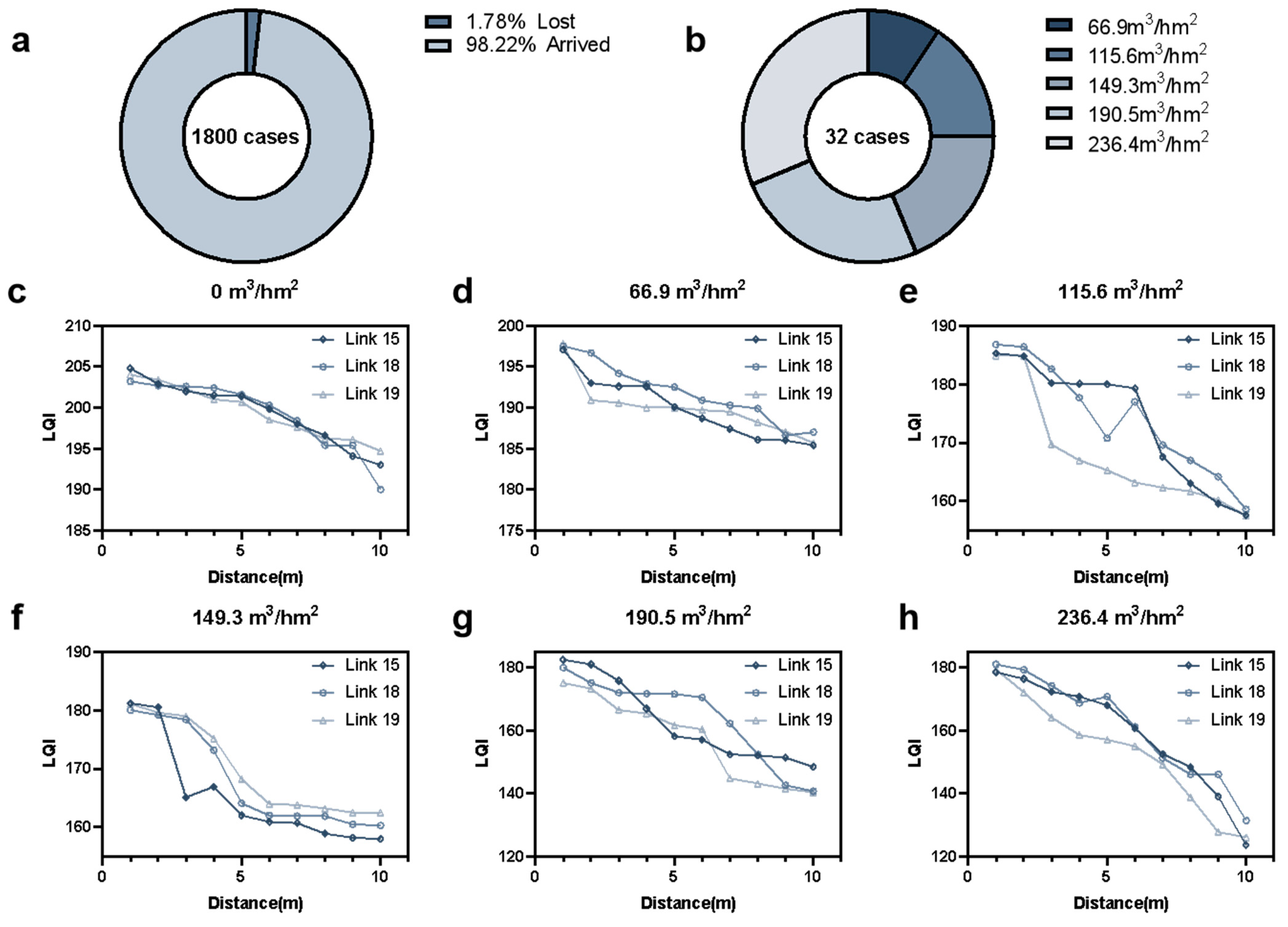
3.1. Packet Loss Rate and LQI Analysis of Local Self-Organizing Network

Figure 6a shows the overall packet loss of 1800 packets transmitted by the terminal of the local self-organizing network, Figure 6b shows the packet loss of the local self-organizing network for each unit area of stumpage, and Figure 6c–h show the variation of LQI of the local self-organizing network with distance for different unit areas of stumpage.
Analyzing Figure 6a, we find that the packet loss rate is only 1.78% in the sample of 1800 packets, and analyzing Figure 6b, we find that the packet loss is positively correlated with the number of standing trees per unit area: the larger the number of standing trees, the more serious the packet loss. Through analysis, it is concluded that the packet loss rate of the local self-organizing network terminal meets the reliability requirements of different firefighting environments.
Analyzing Figure 6c, we find that the change in LQI with the change in distance in the open environment is relatively weak; the LQI of the three links is only about 15, and the link quality is reliable. Comparing Figure 6d with Figure 6e,f, the LQI becomes more affected by the transmission distance of the links when the standing wood accumulation per unit area reaches about 100 m3/hm2.
Analyzing Figure 6g,h, we find that in an extreme environment where the number of standing trees per unit area is very large, the LQI can still be stabilized at about 180 at a distance of 1 m, at more than 140 within a distance of 7 m, and about 125 beyond 7 m. From the analysis, it is concluded that the link quality decreases slowly with increased distance in the forest area without shading; in the forest area with shading, the link quality is more affected by shading. Even in the extreme case of severe shading, the local self-organizing network can still maintain good link quality.

3.2. Packet Loss Analysis for Satellite Communication Network

Figure 7a shows the number of successful and failed data packets received by the satellite communication network terminal at 10°, 30°, 50°, and 75° elevation angles; Figure 7b shows the number of successful and failed data packets sent by the satellite communication network terminal at 10°, 30°, 50°, and 75° elevation angles.
Analyzing Figure 7a, we find that the packet loss rate when the satellite communication network terminal receives data packets is about 75% to 83%; analyzing Figure 7b, we find that the packet loss rate when the satellite communication network terminal sends data packets is about 77% to 85%. Comparing the two figures, it can be seen that the packet loss rate is generally better when sending data than when receiving data. The network packet loss rate is lowest when the elevation angle of the satellite communication network terminal is about 50°.
During firefighting operations in a forest, the firetruck will not always be in the same position, i.e., it will not always work at a fixed angle. However, it is found that even if a firetruck equipped with a satellite communication network terminal is tilted at a certain angle, it can still ensure that the packet loss rate in the whole process is not less than 75%.

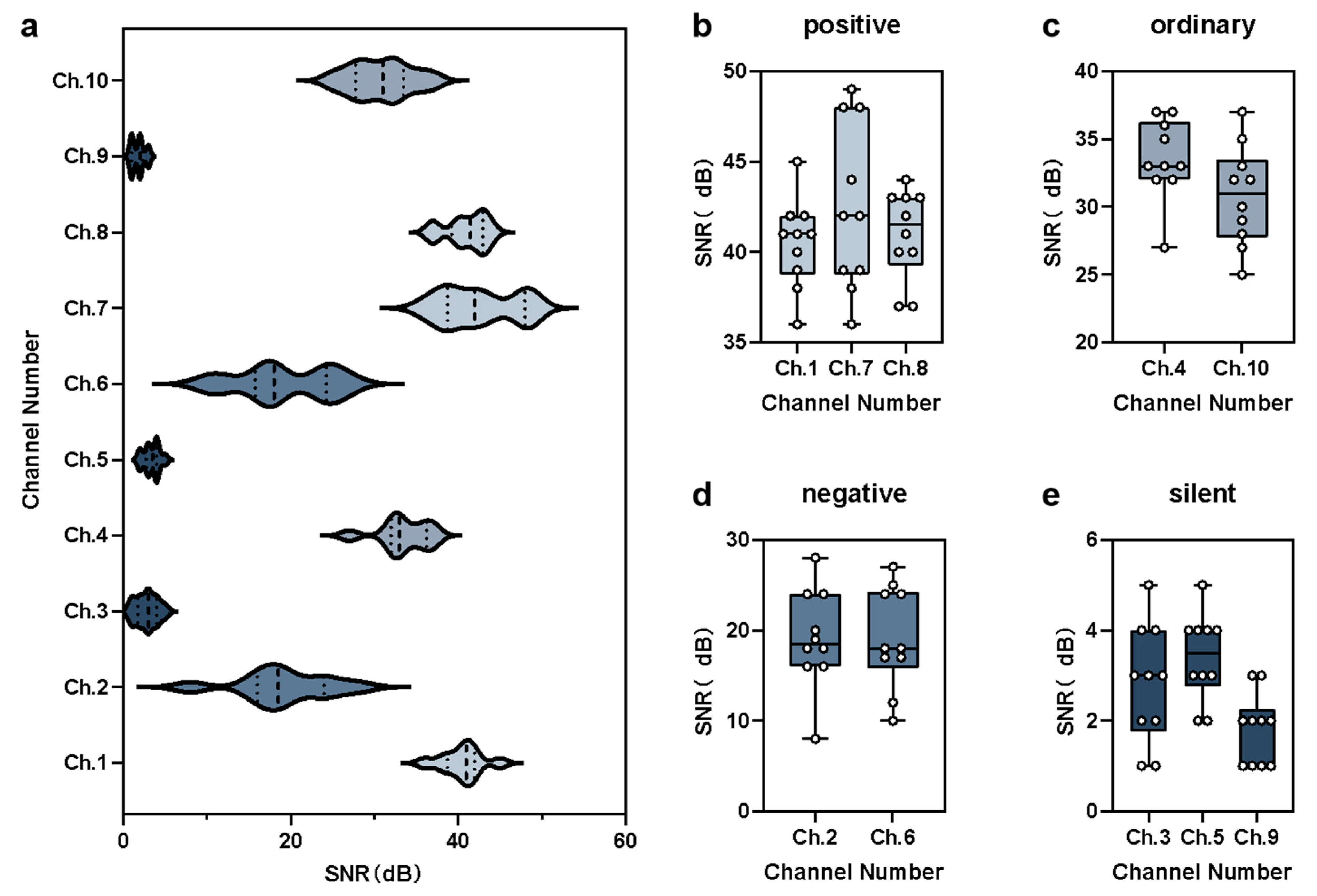
3.3. Signal-to-Noise Ratio Analysis of Satellite Communication Network

Based on the median SNR, the channel activity can be divided into four categories: positive (median SNR ≥ 40), ordinary (median SNR ≥ 20), negative (median SNR ≥ 10), or silent (SNR < 10). Figure 8a shows the overall SNR performance of the 10 channels, and Figure 8b–e show the SNR of positive, ordinary, negative, and silent channels, respectively.
As shown in Figure 8a, more than 50% of the channels were always active or normal active during the experiment. In all moments, the optimal SNR was close to 60, indicating that the overall performance of the satellite communication network channels met the operational requirements. As shown Figure 8b–e, there were three channels with positive activity, two channels with normal activity, two channels with negative activity, and three channels with silent activity. The activity of the 10 channels varied at different moments of the experiment, which indicates that the signal transmission conditions of the channels did not depend entirely on their activity at a given moment. It is concluded from the analysis that the overall channel activity of the working satellite communication network terminal can always meet the transmission requirements of RSMC.
Due to the special communication environment in forested areas, there is no guarantee that there is always a line of sight to the satellite. Therefore, it is necessary to discuss whether the signal has enough SNR redundancy to compensate for the loss of signal caused by tree shading. For satellite digital communications, an SNR of 10 dB or more is usually required to ensure reliable communications. For the 10 channels shown in Figure 8, the overall SNR average value of the test is 23.46 dB, then the average SNR redundancy of all channels is 13.46 dB, and the system has enough redundancy to compensate for the loss of signal caused by tree shading.

4. Discussion

In this study, BeiDou RDSS technology was applied to the process of firefighting operations in forests. In designing a local self-organized network terminal, Zigbee networking technology was used to divide the logical structure of nodes undertaking different tasks and realize automated collection of various kinds of parameters, so as to reduce the workload of on-site firefighters. In designing the satellite communication network terminal, the satellite communication network terminal uses BeiDou RNSS positioning technology (Provided by China’s Beidou satellite navigation system) to determine the geographic coordinates of the fire site and BeiDou RDSS technology to send and receive message data.
In order to test the link quality and packet loss rate of the local self-organized network, we used the LQI, which has high reliability, and analyzed the link quality in different environments with different stump volume, and with packets sent and received continuously. In order to test the link quality and packet loss rate of the satellite communication network, the SNR of 10 channels was determined by simulating the satellite communication process and categorized into different levels of activity, and packets were sent and received at different moments.
The performance experiment of this system used an LF1352JP tracked firetruck, but other types of firetrucks are used as the main firefighting vehicles in the forested areas of Southwest China (Sichuan, Yunnan, and Tibet) [52,53,54]. Since the system uses highly integrated connections and rich interfaces, it can also be embedded into other types of firetrucks.
In addition, since the civil smart card of BeiDou-3 was not available for civil application as a two-way card until now, and only the one-way smart card could be applied, the two-way civil smart card of BeiDou-2 was used in this experiment [55]. Although the performance of communication services provided by BeiDou-3 is more stable compared to BeiDou-2, its tariff is higher, and BeiDou-2 will not stop being maintained and the official government has not released any adjustment to the number of channels of BeiDou-2. Therefore, BeiDou-2 can still provide services for forestry firefighting operations for a long time [56].
In the overall testing strategy, there was a lack of different geographic locations as references for system performance testing, and insufficient comparison samples and repetitive trials in some of the experiments [57]. In future work, we will continue to refine the functional division of the forest fire emergency communication system and develop new technology, including plans to improve the performance and applicability of the system. In addition, due to the special operating environment in forested areas, shading by trees can cause attenuation of the signal. This attenuation can be affected by leaf morphology and depression, etc. In order to ensure the singularity of the test variables, the experiments were set up so that there is always line-of-sight propagation between the terminal and the satellite, and enough redundancy was left to cope with the loss caused by tree shading. In future studies, we will further analyze the extent of attenuation of the signal caused by factors such as foliage morphology and degree of depression in order to improve the analysis of the system performance.

5. Conclusions

In this study, a vehicle-mounted emergency communication system using BeiDou RSMC for firefighting operations in forest areas without a public network was designed, which was realized by applying BeiDou RDSS short message communication. In addition, the research also used Zigbee self-organizing network technology to reliably convert the fire parameters into digital signals and transmit them. The performance of the system was analyzed, and its reliability was assessed after field tests. This study makes the following contributions:
  • By combining BeiDou RDSS short message technology and Zigbee self-organized network technology, a vehicle-mounted emergency communication system using BeiDou RSMC for firefighting operations in forest areas without a public network was designed to realize emergency communication between on-site firefighting operators and a remote command center.
  • Tests on the packet loss rate, LQI, and SNR of the emergency communication system were carried out. The results show that the system has excellent performance and can solve the emergency communication problem in forested areas without a public network, and the reliability of the system meets the requirements of actual firefighting operations.
  • The designed emergency communication system can be mounted on different firetrucks, and other monitoring parameters can be added according to the actual application scenario; at the same time, it can also be matched with BeiDou communication cards with different frequencies and communication levels according to the specific use requirements.

Author Contributions

Conceptualization, C.X.; methodology, S.S. and Z.D.; software, C.X. and Y.Z.; validation, C.X.; formal analysis, Z.D.; investigation, Z.D.; resources, C.X.; data curation, Y.Z.; writing—original draft preparation, C.X.; writing—review and editing, C.X.; visualization, C.X.; supervision, S.S.; project administration, Y.Z.; funding acquisition, S.S. All authors have read and agreed to the published version of the manuscript.

Funding

This study was financially supported by the National Key Research and Development Program of China (2018YFE0207800-04).

Data Availability Statement

The data in this study are available from the authors upon request.

Acknowledgments

The authors thank Northeast Forestry University Experimental Forestry for site support.

Conflicts of Interest

The authors declare no conflicts of interest.

References

  1. Sitnov, S.A.; Mokhov, I.I. A Comparative Analysis of the Characteristics of Active Fires in the Boreal Forests of Eurasia and North America Based on Satellite Data. Izv. Atmos. Ocean. Phys. 2018, 54, 966–978. [Google Scholar] [CrossRef]
  2. Armenteras, D.; Dávalos, L.M.; Barreto, J.S.; Miranda, A.; Hernández-Moreno, A.; Zamorano-Elgueta, C.; González-Delgado, T.M.; Meza-Elizalde, M.C.; Retana, J. Fire-induced loss of the world’s most biodiverse forests in Latin America. Sci. Adv. 2021, 7, 8. [Google Scholar] [CrossRef] [PubMed]
  3. Kumar, G.; Kumar, A.; Saikia, P.; Roy, P.S.; Khan, M.L. Ecological impacts of forest fire on composition and structure of tropical deciduous forests of central India. Phys. Chem. Earth 2022, 128, 13. [Google Scholar] [CrossRef]
  4. Chen, L.; Shao, P.; Chen, Z.; Chen, W. Construction and Application of Emergency Command and Communication System for Forest Fire Fighting. China Emerg. Rescue 2022, 3, 44–47. [Google Scholar] [CrossRef]
  5. Xu, C. Research on the Ability of Forest Fire Bridge to Cope with Large Fire Disasters. J. Wildland Fire Sci. 2023, 41, 63–65. [Google Scholar]
  6. Li, S. The Enlightenment to Forest Fire Prevention and Control in Southwest of China from the Study on “3·29” Forest Fire in Kunming Area in 2006. J. Saf. Sci. Technol. 2009, 5, 48–52. [Google Scholar]
  7. Xing, Z. Brief Analysis Our Country Wisdom Fire Fighting Construction—Take Xian Xi Xian District of Shaanxi Province as the Center Research. Master’s Thesis, Shanxi University, Taiyuan, China, 2023. [Google Scholar]
  8. Zong, X.; Tian, X. Research Progress in Forest Fire Behavior and Suppression Technology. World For. Res. 2019, 32, 31–36. [Google Scholar]
  9. Lippitt, C.D.; Stow, D.A.; Riggan, P.J. Application of the remote-sensing communication model to a time-sensitive wildfire remote-sensing system. Int. J. Remote Sens. 2016, 37, 3272–3292. [Google Scholar] [CrossRef]
  10. Hargreaves, D.; Knight, T.; Brownsword, P. MacDonald Dettwiler real-time emergency management via satellite—Status update and future directions. ISPRS-J. Photogramm. Remote Sens. 2003, 57, 273–280. [Google Scholar] [CrossRef]
  11. He, X. Forest fire monitoring system (I). Remote Sens. Technol. Appl. 1989, 1, 50–56. [Google Scholar]
  12. He, X. Forest fire monitoring system (II). Remote Sens. Technol. Appl. 1989, 1, 9–14. [Google Scholar]
  13. Dong, P.; Dong, K.; Ma, L.; Yu, X.; Wei, J. Estimation of forest fire overfire area based on Landsat8 remote sensing data--Taking the “3.18” fire in Hezhang County, Bijie City, Guizhou Province as an Example. Sichuan For. Surv. Des. 2022, 1, 14–18. [Google Scholar]
  14. Tan, X.; Li, X.; Liu, S.; Liu, Q.; Li, Z. Forest fire early warning and monitoring techniques using satellite remote sensing in China. Natl. Remote Sens. Bull. 2020, 24, 511–520. [Google Scholar]
  15. McClure, C.D.; Pavlovic, N.R.; Huang, S.H.; Chaveste, M.; Wang, N.X. Consistent, high-accuracy mapping of daily and sub-daily wildfire growth with satellite observations. Int. J. Wildland Fire 2023, 32, 694–708. [Google Scholar] [CrossRef]
  16. Park, B.-S.; Cho, I.-J.; Lim, J.-H.; Kim, I.-B. Forest Fire Monitoring System Using Satellite. J. Converg. Inf. Technol. 2021, 11, 143–150. [Google Scholar] [CrossRef]
  17. Kim, J.; Duk-jin, K. Satellite Imagery and AI-based Disaster Monitoring and Establishing a Feasible Integrated Near Real-Time Disaster Monitoring System. J. Korean Assoc. Geogr. Inf. Stud. 2020, 23, 236–251. [Google Scholar] [CrossRef]
  18. Sun, K.; Chen, Y.W.; Wang, P.; He, R.J. Application of agile Earth-observing satellite in disaster monitoring. Res. J. Chem. Environ. 2012, 16, 56–61. [Google Scholar]
  19. Dvorkin, V.V.; Karutin, S.N.; Kurshin, V.V. Method for monitoring the glonass global navigation satellite system by means of a differential correction and monitoring system. Meas. Tech. 2012, 55, 284–291. [Google Scholar] [CrossRef]
  20. Faeng, Y.; Lei, C.; Pan, Y.; Zhang, C. Forest fire monitoring based on satellite remote sensing technology. Geomat. Technol. Equip. 2022, 24, 15–19. [Google Scholar] [CrossRef]
  21. Li, Y.; Li, Q. Discussion on forest fire monitoring systems based on satellite data analysis. J. Wildland Fire Sci. 2019, 1, 25–29+43. [Google Scholar]
  22. Deng, S.; Ai, N.; Li, M.; An, Y.; Lei, J. Star-Earth Converged Communication Network Architecture for Forest Fire Emergency Communication Applications. Satell. Appl. 2022, 1, 55–60. [Google Scholar]
  23. Teng, B.; Yan, E.; Yan, Z.; Qiao, Y.; Zhang, R.; Cui, H. Research and Design of the Emergency Communication Scheme for Forest Fire. Softw. Guide 2020, 19, 192–196. [Google Scholar]
  24. Wu, H.; Tian, X.; Fu, L.; Wang, X. Application of Beidou Terminal in Forest Fire Early Warning Monitoring System. Satell. Appl. 2023, 1, 35–39. [Google Scholar]
  25. Tan, S. Innovative Development and Forecast of BeiDou System. Acta Geod. Cartogr. Sin. 2017, 46, 1284–1289. [Google Scholar]
  26. Liang, X. Research on Key Technologies of BeiDou-3 NavigationSatellite System RDSS Communication Service. Master’s Thesis, University of Electronic Science and Technology of China, Chengdu, China, 2023. [Google Scholar]
  27. Xie, J.; Zhuang, J.; Kang, C. Internet of Things Technology and Application Based on Beidou System. J. Nanjing Univ. Aeronaut. Astronaut. 2021, 53, 329–337. [Google Scholar] [CrossRef]
  28. IEEE 802.15.4-2020; IEEE Standard for Low-Rate Wireless Networks. IEEE Standards Association: Piscataway, NJ, USA, 2020.
  29. Padma, B.; Erukala, S.B. End-to-end communication protocol in IoT-enabled ZigBee network: Investigation and performance analysis. Internet Things 2023, 22, 100796. [Google Scholar] [CrossRef]
  30. Nafkha, A. Implementation and Comparison of Low Power Wireless Protocols in a Mesh Topology. Master’s Thesis, Instituto Politecnico de Braganca, Braganca, Portugal, 2021. [Google Scholar]
  31. Wang, J.; Li, C. The Development and Innovation of the BeiDou Navigation Satellite System. Stud. Hist. Nat. Sci. 2023, 42, 365–376. [Google Scholar]
  32. Yang, Y.; Xu, Y.; Li, J.; Yang, C. Progress and performance evaluation of Bei Dou global navigation satelite system: Data analysis based on BDS-3 demonstration svstem. Sci. Sin. 2018, 48, 584–594. [Google Scholar]
  33. Wei, Z.; Ma, M.; Yan, J.; Cai, W. Design of Wireless Fire Alarm System Based on CC2530. J. Astronaut. Metrol. Meas. 2021, 41, 66–71. [Google Scholar]
  34. Del-Valle-Soto, C.; Mex-Perera, C.; Nolazco-Flores, J.A.; Velázquez, R.; Rossa-Sierra, A. Wireless Sensor Network Energy Model and Its Use in the Optimization of Routing Protocols. Energies 2020, 13, 728. [Google Scholar] [CrossRef]
  35. Zhang, X.; Meng, Y.; Cai, Z.; Tian, B.; Cheng, X.; Qin, Y. Research on landslide monitoring data acquisition system based on Beidou short message communication and internet of things. Prog. Geophys. 2022, 37, 911–919. [Google Scholar]
  36. Tabouche, A.; Djamaa, B.; Senouci, M.R. Traffic-Aware Reliable Scheduling in TSCH Networks for Industry 4.0: A Systematic Mapping Review. IEEE Commun. Surv. Tutor. 2023, 25, 2834–2861. [Google Scholar] [CrossRef]
  37. Jaksic, B.; Todorovic, J.; Jovanovic, M.; Bandjur, M.; Bandjur, D. Impacts of Diversity Technique Application in Order to Reduce the Fading in IEEE 802.15.4 Networks. Appl. Sci. 2023, 13, 9775. [Google Scholar] [CrossRef]
  38. Cai, J.; Shu, Y.; He, W. Research on Channel Coding in Beidou Navigation System. Radio Eng. 2017, 47, 47–53. [Google Scholar]
  39. Gao, W.; Sui, Y.; Li, M.; Hu, Z.; Su, C.; Su, M. Application Mode and Usage Suggestion of BDS Downlink Navigation Signals for RNSS Service. Geomat. Inf. Sci. Wuhan Univ. 2023, 48, 1444–1454. [Google Scholar] [CrossRef]
  40. Yang, Y.; Li, J.; Wang, A.; Xu, J.; He, H.; Guo, H.; Shen, J.; Dai, X. Preliminary assessment of the basic navigation and positioning performance of the Beidou regional satellite navigation system. Sci. Sin. 2014, 44, 72–81. [Google Scholar]
  41. Sun, S.; Chen, J.; Ma, W.; Chu, J.; Yang, J.; Xu, J.; Tang, H.; Fu, L.; Sheng, J. A Kind of Tracked Forest Fire Fighting Vehicle. Patent CN108478964A, 4 September 2018. [Google Scholar]
  42. Sun, S.; Ren, C.; Li, T.; Chen, J.; Ma, W.; Chu, J. Trafficability analysis of improved forest fire engine based oncrawler chassis. Trans. Chin. Soc. Agric. Eng. 2018, 34, 61–67. [Google Scholar]
  43. Song, Z.; Pang, B.; Weng, Y.; Lu, H.; Xue, F. Application of BeiDou Short Message in Global Maritime Distress and Safety Communication Service. Navig. China 2022, 45, 65–69+77. [Google Scholar]
  44. Chu, X.; Wang, Y.; Jin, G.; Fan, H.; Zhou, Z. Variation in Growth and Wood Property and the Structure Differentiation of Schima superba Plantation with Different Sites, Stand Densities and Ages. Sci. Silvae Sin. 2014, 50, 152–159. [Google Scholar]
  45. Bruchwald, A.; Dmyterko, E. Stochastic model for calculating the volume of wind-broken and wind-thrown wood as well as of deadwood. Sylwan 2014, 158, 258–266. [Google Scholar]
  46. Lei, Y.; Mao, X. Integrating UAV-LiDAR and Sentinel-2 for Growing Stock Volume Estimation. For. Eng. 2023, 39, 46–54. [Google Scholar]
  47. Meka, S. Improving Link Quality Estimation in Zigbee Networks; Northern Illinois University: DeKalb, IL, USA, 2019. [Google Scholar]
  48. Nuruzzaman, M.T.; Ferng, H.W. Design and evaluation of an LQI-based beaconless routing protocol for a heterogeneous MSN. Wirel. Netw. 2020, 26, 699–721. [Google Scholar] [CrossRef]
  49. Shen, B.; Qin, J. A Novel SNR Estimation Method Based on Spread Spectrum Signal in Troposcatter Communication. Trans. Beijing Inst. Technol. 2021, 41, 873–877. [Google Scholar]
  50. He, Y.; Wang, Z.; Wang, Q.; Mao, Y. Quality Analysis of Observation Data of BeiDou Global Experimental Satellites. Bull. Surv. Mapp. 2018, 12, 1–5. [Google Scholar] [CrossRef]
  51. Ansari, K.; Bae, T.S.; Seok, H.W.; Kim, M.S. Multiconstellation global navigation satellite systems signal analysis over the Asia-Pacific region. Int. J. Satell. Commun. Netw. 2021, 39, 280–293. [Google Scholar] [CrossRef]
  52. Zhu, C. Research on Improved Design and Retrofitting Methods of Multifunctional Forest Firefighting Vehicles. China South. Agric. Mach. 2023, 54, 139–141. [Google Scholar]
  53. Li, M. 30 Python all-terrain forest firefighting vehicles passed the acceptance test. Dual Use Technol. Prod. 2020, 5, 65. [Google Scholar]
  54. Sun, S.; Zhang, S.; Li, Y.; Wu, J.; Chu, J. Studies of several large-scale forestry operating vehicles at home and abroad and prospect of vehicle type design. J. Beijing For. Univ. 2019, 41, 154–166. [Google Scholar] [CrossRef]
  55. Liu, Q.; Pan, X.; Wang, L.; Li, M. Reuse analysis of BeiDou-2 retired GEO satellite. In Proceedings of the 11th Annual China Satellite Navigation Conference—S02 Navigation and Location Services, Chengdu, China, 24 November 2020; p. 5. [Google Scholar]
  56. Lv, L.; Han, M.; Zhang, J.; Lv, Z. Comparative analysis of Beidou-3 and Beidou-2 satellite signals. Digit. Technol. Appl. 2022, 40, 14–16+124. [Google Scholar] [CrossRef]
  57. Feng, K.; Qiao, B.; Cao, L.; Hao, J.; Zhang, H. Analvsis of the Composition of Germplasm Resources of Forest Tree Seed Base in Heilongiiang Province. For. Eng. 2023, 39, 57–62. [Google Scholar]
Figure 1. System architecture of vehicle-mounted emergency communication system based on BeiDou RSMC for firefighting operations in forest areas without a public network.
Forests 15 01185 g001
Figure 2. (a) Distribution of Zigbee channels over 2.4 GHz band. (b) Four-layer structure of Zigbee protocol stack. (c) Logical structure between nodes of local self-organizing network.
Forests 15 01185 g002
Figure 3. Signal processing flow of satellite communication network terminal.
Forests 15 01185 g003
Figure 4. (a) System assembly structure; installation locations of (b) end device node A, (c) end device node B, (d) end device node C, (e) and coordinator node.
Forests 15 01185 g004
Figure 5. (a) Fire occurs; (b) A arrives at predetermined stationing position; (c) A conducts firefighting operations; (d) fire extinguished; (e) B observes fire site parameters reported by A; (f) B monitors fire suppression by A.
Forests 15 01185 g005
Figure 6. (a) Overall packet loss for 1800 packets. (b) Packet loss for each unit area of stumpage; (c) LQI with 0 m3/hm2 unit area of stumpage; (d) LQI with 66.9 m3/hm2 unit area of stumpage; (e) LQI with 115.6 m3/hm2 unit area of stumpage; (f) LQI with 149.3 m3/hm2 unit area of stumpage; (g) LQI with 190.5 m3/hm2 unit area of stumpage; (h) LQI with 236.4 m3/hm2 unit area of stumpage.
Forests 15 01185 g006
Figure 7. (a) Number of successful and failed data packets received; (b) number of successful and failed data packets sent.
Forests 15 01185 g007
Figure 8. (a) Overall SNR performance of 10 channels; (b) SNR for positive channels; (c) SNR for ordinary channels; (d) SNR for negative channels; (e) SNR for silent channels.
Forests 15 01185 g008
Table 1. Major wireless communication technologies and their characteristics.
Communications TechnologyBluetoothWi-FiZigbeeZ-WaveLoRa
General Connection Distance≤10 m≤100 m≤20 m≤30 m≤5 km
Power WastageMediumHighLowLowLow
Self-Organized or NotNNYYN
Common Application ScenariosProximity personal device connectivityMulti-device high-speed transmissionIoT devices and environmental monitoringSmart home and automation equipmentRemote sensor networks
Table 2. Types of sensors connected to each node of local self-organizing network and parameters monitored.
Logical Role of NodeConnected SensorsParameters Monitored
Coordinator Node--Summarize all parameters
End Device Node AInput-level transmitterWater remaining in tank
Infrared temperature sensorsWater temperature in tank
End Device Node BTemperature and humidity sensorsTemperature and humidity in environment
Wind speed and direction sensorsInstantaneous wind speed and direction
End Device Node CCarbon monoxide concentration sensorCarbon monoxide concentration
Smoke concentration sensorSmoke concentration
Sulfide concentration sensorSulfide concentration
Disclaimer/Publisher’s Note: The statements, opinions and data contained in all publications are solely those of the individual author(s) and contributor(s) and not of MDPI and/or the editor(s). MDPI and/or the editor(s) disclaim responsibility for any injury to people or property resulting from any ideas, methods, instructions or products referred to in the content.

