Article

Application of Unmanned Aerial Vehicle and Airborne Light Detection and Ranging Technologies to Identifying Terrain Obstacles and Designing Access Solutions for the Interior Parts of Forest Stands

1
Department of Landscape Management, Faculty of Forestry and Wood Technology, Mendel University in Brno, Zemědělská 3, 613 00 Brno, Czech Republic
2
Department of Forest Management and Applied Geoinformatics, Faculty of Forestry and Wood Technology, Mendel University in Brno, Zemědělská 3, 613 00 Brno, Czech Republic
*
Author to whom correspondence should be addressed.
Forests 2025, 16(5), 729; https://doi.org/10.3390/f16050729
Submission received: 21 January 2025 / Revised: 17 April 2025 / Accepted: 18 April 2025 / Published: 24 April 2025
(This article belongs to the Section Forest Operations and Engineering)

Abstract

:
We applied UAV (Unmanned Aerial Vehicle) and ALS (Airborne Laser Scanning) remote sensing methods to identify terrain obstacles encountered during timber extraction in the skidding process with the aim of proposing accessibility solutions to the inner parts of forest stands using skidding trails. At the Vítovický žleb site, located east of Brno in the South Moravian Region of the Czech Republic, we analysed the accuracy of digital terrain models (DTMs) created from UAV LiDAR (Light Detection and Ranging), RGB (Red–Green–Blue) UAV, ALS data taken on site and publicly available LiDAR data DMR 5G (Digital Model of Relief of the Czech Republic, 5th Generation, based on airborne laser scanning, providing pre-classified ground points with an average density of 1 point/m2). UAV data were obtained using two types of drones: a DJI Mavic 2 mounted with an RGB photogrammetric camera and a GeoSLAM Horizon laser scanner on a DJI M600 Pro hexacopter. We achieved the best accuracy with UAV technologies, with an average deviation of 0.06 m, compared to 0.20 m and 0.71 m for ALS and DMR 5G, respectively. The RMSE (Root Mean Square Error) values further confirm the differences in accuracy, with UAV-based models reaching as low as 0.71 m compared to over 1.0 m for ALS and DMR 5G. The results demonstrated that UAVs are well-suited for detailed analysis of rugged terrain morphology and obstacle identification during timber extraction, potentially replacing physical terrain surveys for timber extraction planning. Meanwhile, ALS and DMR 5G data showed significant potential for use in planning the placement of skidding trails and determining the direction and length of timber extraction from logging sites to forest roads, primarily due to their ability to cover large areas effectively. Differences in the analysis results obtained using GIS (Geographic Information System) cost surface solutions applied to ALS and DMR 5G data DTMs were evident on logging sites with terrain obstacles, where the site-specific ALS data proved to be more precise. While DMR 5G is based on ALS data, its generalised nature results in lower accuracy, making site-specific ALS data preferable for analysing rugged terrain and planning timber extractions. However, DMR 5G remains suitable for use in more uniform terrain without obstacles. Thus, we recommend combining UAV and ALS technologies for terrain with obstacles, as we found this approach optimal for efficiently planning the logging-transport process.

1. Introduction

In forestry in the Czech Republic, terrain accessibility for logging and transport vehicles is assessed based on the logging-transport terrain classification [1], which considers the slope of the terrain, its load-bearing capacity, and obstacles. These obstacles include terrain irregularities over 0.5 m in height, terrain depressions, and trenches deeper than 0.5 m and narrower than three times their depth. These irregularities are considered relevant for terrain passability assessment if they are spaced less than 5 m apart for wheeled or tracked vehicles. In terrain with obstacles where such vehicles cannot be used for timber extraction, the task is usually carried out by cableways or horses [2].
To identify these locations, the choice of extraction technology is based on map data when processing Regional Forest Development Plans and edaphic categories (an edaphic category is a unit differentiating forest sites based on physical and chemical soil and terrain properties). Obstacles to the logging-transport process are assumed in edaphic categories identified and marked as acidic rocky and enriched rocky categories, and physical verification in the field is subsequently carried out for these obstacles. However, this approach is time-consuming, economically inefficient, and may not cover all locations with obstacles.
In the operational planning of the logging-transport process, the direction and type of machinery or systems for timber extraction and the slope of the terrain are essential factors directly influencing the choice of extraction methods. Refs. [2,3] state that a terrain slope of up to 30% is the average limit for standard wheeled extraction machines. However, this value depends on the surface conditions, obstacles, and the soil load-bearing capacity. Some authors [2,3,4] recommend using alternative extraction methods for steeper slopes.
Timber extraction involves transporting timber along skidding tracks and skidding trails, which consists of moving the timber from the logging site to a forest road and landing. This task is typically performed using machines, such as a skidder, which enables efficient timber transport even across rugged terrain and allows for moving timber in bundles [5,6]. The productivity and costs of timber extraction are influenced by the slope of the terrain, the extraction distance, and operator experience. These variables significantly impact logging operations, as well as the efficiency and the economics of the logging-transport process [6,7,8,9]. The distance over which timber must be extracted is key in planning forest operations, directly affecting costs [10] and efficiency [11]. In addition to cost, [12] mentions the increasingly important environmental concerns when using forest machinery. The author also notes that DTMs created based on aerial-photogrammetric surveys and contour digitisation are only moderately accurate. Using LiDAR data would improve the accuracy of the results [13]. Decision-making in forest operations is complex, so GIS and DTMs are suitable for assessing terrain and logging parameters when planning extraction [14]. LiDAR mapping of rock outcrops has been focused more on open areas such as hot massifs, mining sites, and landslides [15,16,17,18].
Documenting terrain in detail is usually done using traditional geodetic methods and instruments such as the GNSS (Global Navigation Satellite System) or total stations. This process could be more efficient and faster in large or rugged areas. The collected data are typically used to create and evaluate a DTM, the quality of which depends on the accuracy of the instruments and methods used, and especially on the number of measured points [19]. In difficult-to-access terrain, data collection is both physically challenging and time-intensive, and poor accessibility may prevent coverage of the entire area. Often, measurements are simplified by surveying representative regions using appropriate tools, as noted by [20,21]. For this reason, remote sensing methods are increasingly being employed.
The most common method of collecting terrain data over large areas is ALS, which achieves a point density on the terrain of around 4–15 points per m2, depending on conditions such as scanning time and vegetation cover. The high-flying altitude of 500–1500 m enables rapid data collection over vast areas, making the process efficient and time-effective [22,23].
UAVs can be deployed quickly and repeatedly to obtain high-resolution data, offering greater flexibility than manned or satellite systems. Their ability to carry various sensors enables UAVs to perform a broader range of tasks than traditional aircraft or satellite platforms [24].
UAVs are commonly equipped with GNSS, digital cameras, or laser scanners, combining high spatial resolution, ease of use, and relatively low operating costs [25]. On the other hand, georeferencing data collected by UAVs may involve using GCPs (ground control points), which reduces the advantages of fast and efficient mapping in remote areas [26]. One solution would be to use UAVs with RTK (Real Time Kinematic) GNSS, where the position of each image is captured with an accuracy of a few centimetres [27].
Because UAVs can fly at low altitudes (e.g., 50 m above the ground), UAV LiDAR also benefits from a higher point density per m2. According to [28], the density of laser pulses hitting the terrain is around 170 points per m2. However, a significant drawback of UAV LiDAR is the high cost of the equipment.
A cheaper alternative is to use RGB cameras and subsequently process the images photogrammetrically, for example, using the SfM (Structure from Motion) algorithm [29,30]. Given the resolution of the camera images, the output is a point cloud with very high density; however, vegetation remains a problem. Terrain information can thus only be obtained in less dense stands and outside the growing season [28,31,32].
With the increasing availability of UAVs, RGB cameras, and laser scanners, many applications of these systems have been recorded in the last decade; for example, in archaeology [28], modelling rock formations and boulders [33,34], ecology [35], terrain modelling [36,37], monitoring bark beetle infestation [38], forest inventory [39], and distinguishing different types of vegetation [40]. Compared to LiDAR data, photogrammetric data are more dependent on the quality of the images, which is influenced by factors such as the distance from the target, image resolution, capture angle, and the specific methodology used during data acquisition, as well as the parameters set in the computational processing [41].
Our research aimed to evaluate the effectiveness of various remote sensing methods for identifying terrain obstacles during timber extraction. Data were obtained using UAVs (laser scanning and RGB images), airborne laser scanning (ALS), and publicly available DMR 5G data from the Czech Office for Surveying, Mapping and Cadastre Geoportal. Another objective was to assess the use of ALS and DMR 5G data in designing skidding trails connecting to existing skidding tracks and a forest road network. This includes determining the extraction direction and distances for skidding trails with GIS tools and measuring skidding distances from logging sides to forest roads and stacks. The integration of GIS tools aims to optimise timber extraction operations and enhance the overall efficiency of forest operations.

2. Materials and Methods

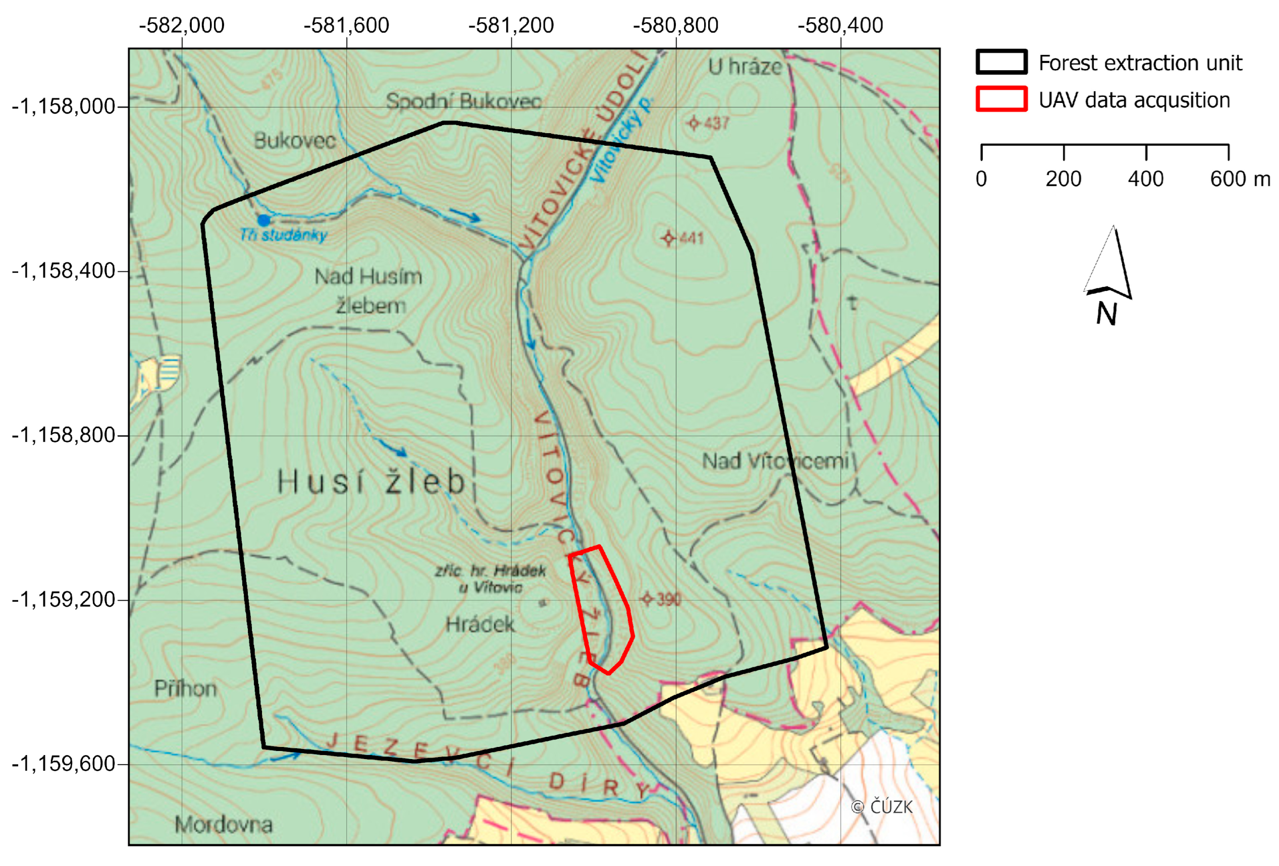
2.1. Data Collection

We collected data in the Vítovický žleb locality (Figure 1), situated approximately 20 km east of the city of Brno (Figure 1). This area encompasses the valley of the Vítovický stream, characterised by mixed forest cover predominantly composed of Scots pine 70% (Pinus sylvestris L.), English oak 20% (Quercus robur L.), and, sporadically, Norway spruce 10% (Picea abies (L.) H. Karst.). The locality features a deeply incised valley with numerous conglomerate outcrops and boulders, while the terrain above the valley primarily exhibits plateau characteristics.
A designated forest extraction unit (Figure 2) was established in the area, covering 186 ha, featuring a unified direction for timber extraction, and containing terrain obstacles to verify their identification. The area includes a main forest road providing access along the watercourse in the deeply incised valley. ALS data with varying point densities were used to design skidding trails for extraction technologies in the interior parts of forest stands. Specifically, data from the DMR 5G from 2013, consisting of pre-classified ground points with an average density of 1 point/m2, and data from a separate aerial laser scan (ALS) of the area in spring 2022 (outside the vegetation period) with an average density of 12 points/m2 before ground point classification. Both datasets in LAS format were processed using ArcGIS Pro 3.4 software. These data were also used to verify the identification of terrain obstacles for timber skidding and to specify the direction and length of timber extraction from logging sites to forest road landing.
In addition to ALS data, we imaged and scanned a 2.9 ha portion of the valley (Figure 2) with terrain obstacles using UAVs with RGB cameras (hereafter referred to as RGB UAVs) with a resolution of 12 megapixels and subsequent photogrammetric processing, and used unmanned laser scanning (hereafter referred to as ULS—Unmanned Laser Scanning) in March 2022 outside the vegetation period to ensure sufficient terrain visibility for RGB images and ULS. RGB imaging was conducted using a DJI Mavic 2 Enterprise drone (SZ DJI Technology Co., Ltd., Shenzhen, China) on a planned flight path with 85% overlap between images and 85% between flight lines. For ULS, we used a DJI M600 Pro hexacopter (SZ DJI Technology Co., Ltd., Shenzhen, China) carrying a GeoSLAM Horizon (GeoSLAM, Nottingham, UK) laser scanner. Thanks to SLAM technology, this scanner was independent of GNSS signals and allowed scanning at a frequency of up to 300,000 points per second. To georeference UAV and ULS data, we placed six GCPs in the field, with their positions defined using a Trimble R12i GNSS (Trimble In., Sunnyvale, CA, USA). All data were transformed into the Czech national coordinate system S-JTSK.
We processed images captured with the RGB camera into a dense point cloud and georeferenced them based on GCPs in AGISOFT Metashape Professional 2.1 software (Agisoft LLC, St. Petersburg, Russia). Data from GeoSLAM Horizon were processed in GeoSLAM Hub 6.1 and GeoSLAM Draw 4.0 software (GeoSLAM Ltd., Nottingham, UK), where the point cloud was placed into the coordinate system based on identifying control points and input coordinates. We classified ground points for all data (except DMR 5G) using ArcGIS Pro software’s Classify LAS Ground algorithm with the Aggressive Classification method. To compare the accuracy of the data, we deliberately did not apply any outlier filtering after the classification of ground points, but the Classify LAS Ground tool allows the removal of low-noise and high-noise points during processing. We created DTMs from the point clouds in the ArcGIS environment using the LAS Dataset to Raster tool. The average density of ground points after classification is shown in Table 1. Given the point density, a DTM with a resolution of 1.0 m was created from DMR 5G data, a DTM with a resolution of 0.5 m from ALS data, and a DTM with a resolution of 0.1 m from RGB UAV and ULS data (Table 1). Further DTM processing was conducted using ArcGIS Pro 3.4.0 software.

2.2. DTM Accuracy in Identifying Terrain Obstacles

We used the RGB UAV and ULS data collection methods in an area for terrain obstacle verification, evaluating them with ALS and DMR 5G data. The elevations of the DTMs created were subtracted from each other, and the mean, standard deviation, and maximum and minimum differences between these models were determined. Next, we used the Focal Statistics tool with the Range function set in a circular neighbourhood of the pixel up to a distance of 1 m to detect terrain obstacles. A new raster layer was created for each dataset, representing the elevation differences in the defined neighbourhood, which should indicate rock outcrops and other terrain obstacles. We compared the height detected by the individual DTMs for the highest rock outcrops and calculated the proportion of terrain obstacles higher than 0.5 m.

2.3. Accessing Interior Parts of Forest Stands

Due to their study’s broader application, Pentek et al. [42] used the method to determine the accessibility of terrain for logging and transportation machinery based on its slope. The Czech terrain classification system is based on a more detailed division of slopes and edaphic soil categories with national specifics. In contrast, Pentek et al.’s terrain classification was used due to its simplified approach and broader international applicability. In [42], the accessibility of logging and transportation technologies is defined based on the slope of the terrain and the skidding distance to the extraction site.
Slopes in the extraction unit were classified over the entire area, where only DMR 5G and ALS data with higher point density were available (Figure 3). In the first step, we carried out a slope analysis of the terrain in percentages. However, the results of this were influenced by the number of terrain obstacles in the DTMs we used, so we smoothed the selected DTMs using Focal Statistics with the Mean parameter in a 5 m neighbourhood and performed the slope analysis on the smoothed models. The slope reclassification identified four basic categories (up to 30%, 30%–50%, 50%–70%, and over 70%) [42].
Subsequently, this procedure again detected obstacles, but a five-metre buffer extended them. The parameter of a 5 m obstacle distance was selected because obstacles closer than 5 m make the area inaccessible for wheeled skidders or tracked forwarders, necessitating alternative technologies for timber extraction.
The Basic Geographic Data Base of the Czech Republic (ZABAGED), a vector geographic digital model of the country including the forest road network and skidding tracks, was used to calculate the distance to forest roads and stacks. From the ZABAGED road layer, we selected forest roads with sealed wearing courses and skidding tracks in the extraction unit for timber transport and extraction. Therefore, based on the slope and distance from the chosen forest road, locations with less than 10% slope and an area greater than 100 m2 beside the road were selected for landing. These areas were converted into points and served as timber extraction targets. We then determined the extraction distance from the theoretical logging sites to these points.
We created a regular 50 × 50 m grid of potential logging sites (745 sites) to simulate the location of thinning or regeneration harvesting in the forest stand (Figure 3). Although it is not possible to use skidding with wheeled or tracked forwarders on the slopes of the deep valley, an analysis of the slope length in the steepest places revealed that the length did not exceed 150 m, and therefore skidding was possible with the help of a winch on a specialised forest tractor. The same timber extraction technology was then used on the plateau of the transport segment locality. Subsequently, a cost surface solution was calculated, considering both the accessibility of the locations and the selection of extraction technologies. A classified slope layer was divided into four categories: terrain obstacles higher than 0.5 m with a 5 m buffer zone, forest roads, skidding tracks from ZABAGED, and designated timber stacks. The cost surface was developed based on the definition of passability from 1 to 10,000 and barriers for the most frequently used technologies in the locality, skidding with a tractor winch or forwarder extraction. The classification for creating the cost surface is shown in Table 2.
This procedure was performed for the DMR 5G and ALS DTMs. Subsequently, the shortest skidding routes to the extraction sites were calculated in ArcGIS Pro 3.4 using the Distance Accumulation and Optimal Path tools (Figure 3). The analysis output was directly vectoring routes to determine the direction, placement of skidding trails, and length of timber extraction.

3. Results

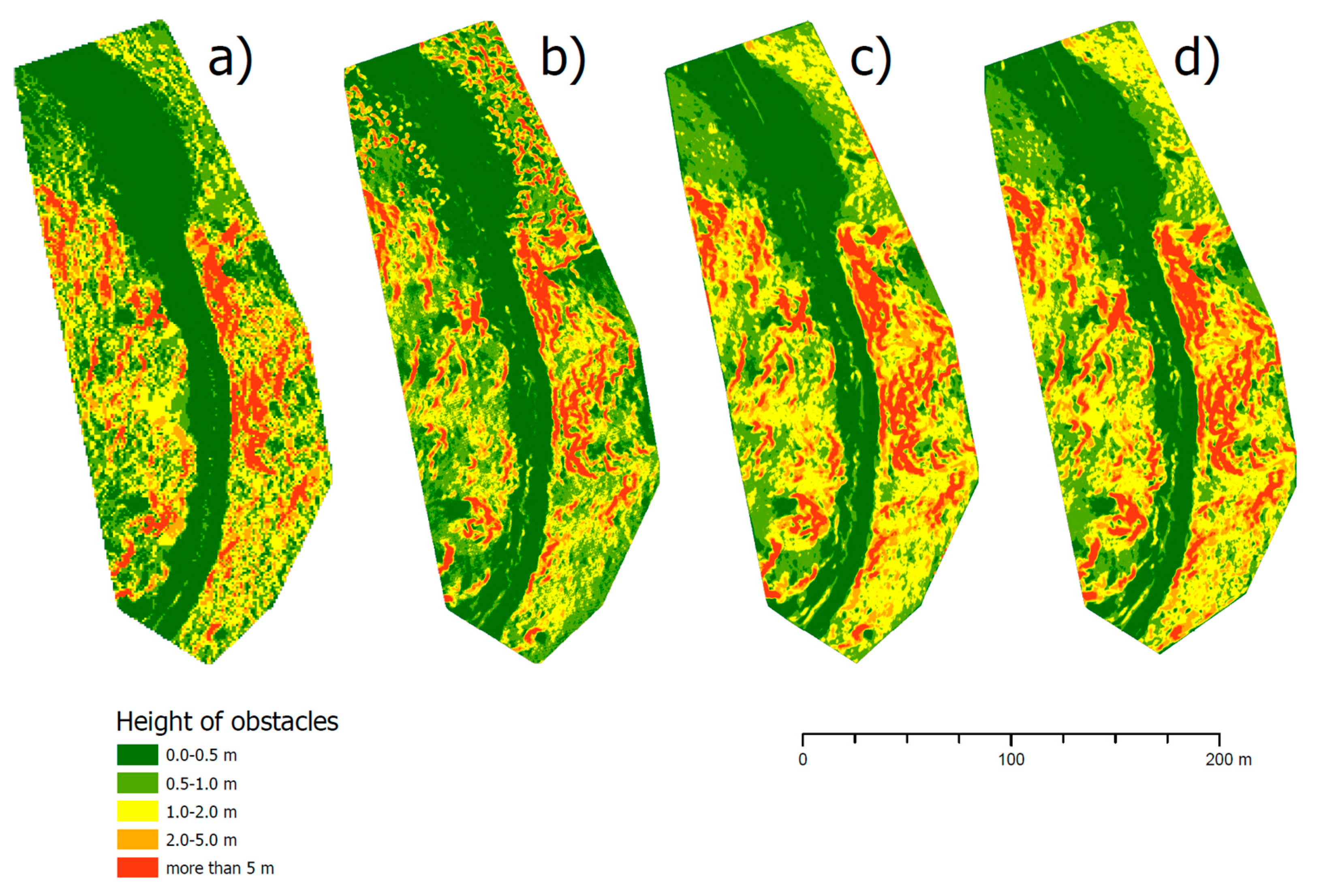
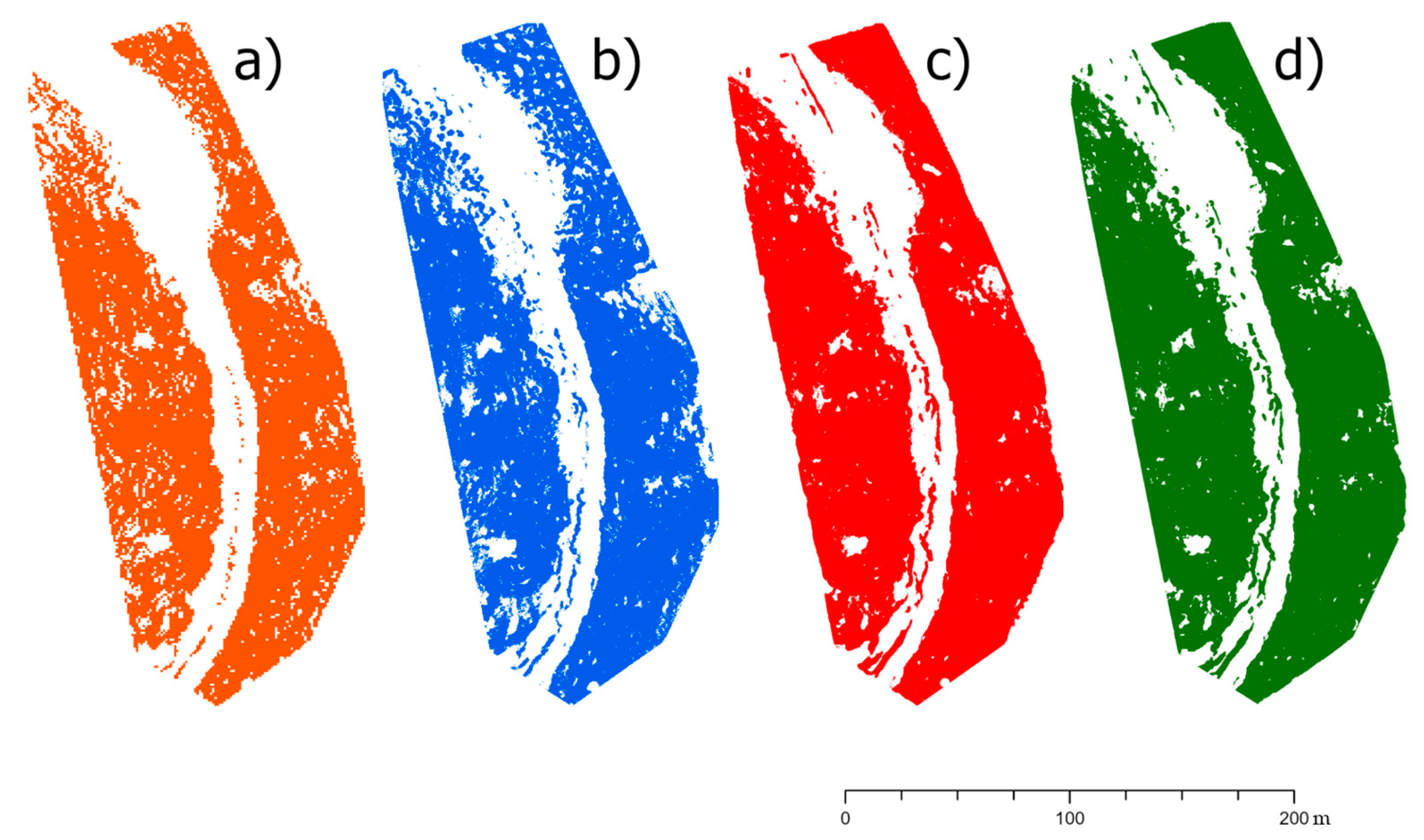
3.1. Evaluating DTM Accuracy in Identifying Terrain Obstacles

Table 3 evaluates mutual height deviations between the elevations of the DTMs created from the data sources. The mean and standard deviations assess the accuracy of the various methods.
The results of the ULS and RGB UAV methods are comparable, with an average deviation of 0.06 m, confirming their high accuracy. In contrast, the ALS results show an average deviation of 0.2 m, and DMR 5G as much as 0.71 m, almost 12 times higher than that of the ULS and RGB UAV.
The quality of DTMs affects the model’s ability to detect terrain obstacles accurately. Differences in quality and the ability to capture terrain details based on the categorised heights of obstacles are illustrated in Figure 4. The detail of the terrain thus also influences the calculation of skidding routes, as the quality of the DTM can exceptionally affect the final extent of small obstacles up to 0.5 m (Figure 4 and Figure 5, Table 4).
We found significant differences among the methods in the detection of terrain obstacles, particularly in the height of the highest rocky formations and the total area of obstacles higher than 0.5 m. Within the examined area of 28,806 m2, the most obstacles higher than 0.5 m were detected using ULS and RGB UAV data, while the least were detected using ALS and DMR 5G data (Table 4). In the case of ULS and RGB UAV data, the differences between the highest rock obstacles were only in the order of tens of centimetres, while ALS data overestimated the height. Conversely, DMR 5G data significantly underestimated it. The density of the point cloud and the subsequent detail of the DTM substantially impacted the accuracy of terrain obstacle detection.

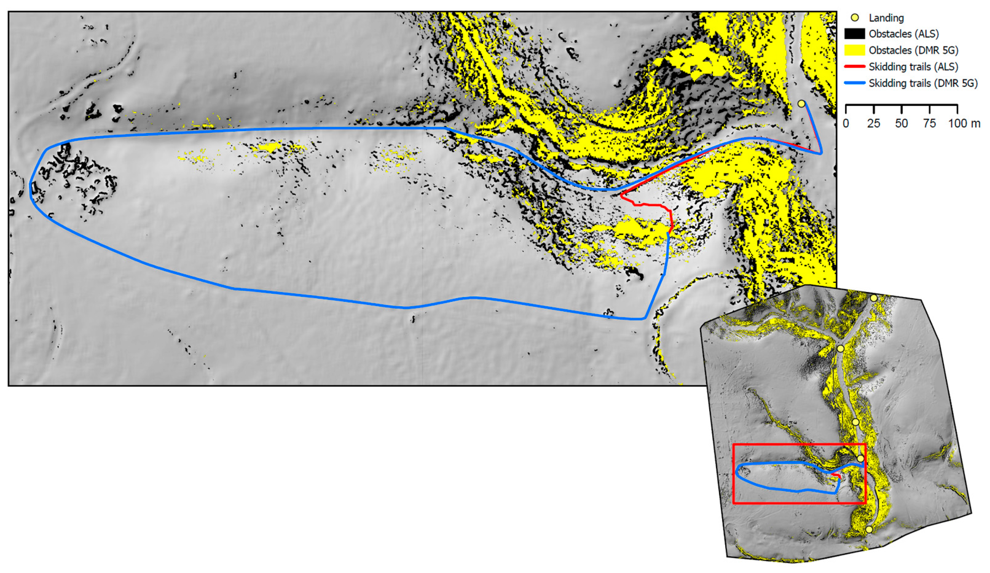
3.2. Proposal for Accessing Interior Parts of Forest Stands

Based on the analysis of the ALS and DMR 5G data DTMs, we created vector lines of the shortest skidding trail routes to skidding tracks, as shown in Figure 6. In many places, it was evident that the different accuracies of the DTMs, especially the ability to capture terrain obstacles, significantly impacted the calculation of the skidding trail routes from the assumed logging sites. Thus, the lengths of the skidding trail routes also differed (Table 5). The difference detected in the total length of skidding trails was slight; however, as shown in Figure 6, in many cases the route planning differed specifically due to the terrain obstacles detected by ALS, a DMT 5G resolution. For each logging site, the differences in skidding distances derived from ALS and DMR 5G were calculated, and the average, maximum, and minimum differences were evaluated (Table 6). In most cases (primarily in uniform terrain without obstacles), the source data did not significantly impact the planning of skidding trails, and the differences in lengths were minimal. However, in several locations, completely different routes were planned, and in two instances, the lengths of skidding trails from DMR 5G were more than a kilometre longer than those from ALS.

4. Discussion

This study presents the possibilities and significance of using modern technologies to identify terrain obstacles within the timber extraction process and to plan timber skidding trails. Point clouds with varying point densities per m2 and different collection methods (RGB UAV, ULS, ALS, and publicly accessible laser scanning data provided by the Czech Office for Surveying, Mapping and Cadastre) yielded different results. The RGB UAV and ULS technologies provided the most accurate outputs, with an average elevation deviation of only 0.06 m and a point density exceeding 440 points per m2. ALS, with an average deviation of 0.2 m and a point density of approximately 7 points per m2, was shown to be suitable for efficiently covering larger areas. Publicly available DMR 5G data show the lowest accuracy, with an average deviation of 0.71 m. While the results from UAV data were sufficiently accurate for identifying terrain obstacles that may limit the use of wheeled and tracked skidding machinery, ALS data, including DMR 5G data, did not provide such precision. On the other hand, their extensive coverage of large areas provides sufficient DTM quality for determining skidding direction and the placement of skidding trails in the forest stand extraction unit, with the option for different uses according to their precision. ALS data with precision in this study could be used even in morphologically diverse terrains, whereas DMR 5G would be suitable for uniform terrains.
The results show that the source data for creating DTMs are crucial for accurate obstacle detection. Generally, the greater the density of the point cloud, the greater the accuracy of obstacle detection. Based on our results, it can be stated that the area extent of terrain obstacles decreases with higher point density. The quality of the DTM is essential for subsequent timber skidding planning. As illustrated in Figure 7, using different input data can result in a completely different skidding trail, depending on the extent of the obstacles. The level of terrain detail, specifically the density of the point cloud, significantly affects the accuracy of obstacle detection and can subsequently affect the planning of skidding trails. Using a less accurate model may underestimate the extent of terrain obstacles, and skidding trails may be planned in areas inaccessible to machinery.
If ALS data alone were used, mapping preparation and verification of terrain obstacles in the field would still be necessary, as this step cannot be omitted in such cases. Conversely, UAVs can replace subsequent physical reconnaissance of barriers in the field, allowing forest workers to conduct terrain reconnaissance quickly.
The challenge with all methods of collecting data on the terrain beneath the tree canopy is the timing of data acquisition. Laser pulses have limited penetration through the tree cover during the growing season, particularly in deciduous forests. In the case of RGB data, measurements are often completely unachievable. Therefore, imaging or scanning outside the growing season is preferred. However, this may also present a challenge throughout the year in dense coniferous forests. Thick vegetation can diminish the number of points reaching the terrain, thereby hindering the ability to identify terrain obstacles and accurately determine their height [43]. Errors may also occur due to the ground point classification algorithm employed.
Ref. [44] highlights the importance of precision forestry, even on a small-scale technical application level in forest road planning, which aids managers and owners in decision-making on forestry operations. Using designated skidding trails reduces soil compaction and minimises damage to residual trees without compromising productivity compared to conventional methods. Although winching time increases, this is offset by reduced skidding time, making the approach environmentally and operationally efficient when adequately planned [45]. Ref. [46] highlights that the condition of skidding tracks and trails significantly impacts timber extraction as well as their direction, distance, and slope. Furthermore, [47] emphasises the growing importance of LiDAR technology in assessing their condition.
A drone with an RGB camera can capture data from 1 to 2 km2 per hour under optimal conditions. The lower value applies to rugged terrains or higher resolution. The GeoSLAM Horizon is a lightweight LiDAR scanner with a range of up to 100 m, suitable for detailed forest scanning. Combined with the DJI M600 Pro, this setup can cover approximately 0.5–1 km2 per hour, with actual performance depending on flying height and vegetation density.
ALS data can then be used to determine the actual skidding distance and calculate skidding costs, combined with extraction length and slope maps for designing the forest road network and selecting the type of machinery appropriate for the extraction. The accuracy of DTMs significantly affects route planning. Ref. [48] provides a quantitative approach to determining whether skidding to the roadside or to centralised landing is better and to evaluating and selecting alternative potential stacking locations. Although the model developed in this study offers excellent potential to assist in forest operations planning, model validation involving field comparisons between operator-generated and computer-generated skidding trail networks should be conducted.
While a recently published study by [49] focuses on rock detection and terrain roughness estimation using UAV imagery and deep learning, it represents a focused case study based solely on the segmentation of individual rocks within a confined area. In contrast, our study addresses a broader and more functional definition of terrain obstacles, including not only rocky outcrops but also depressions, accumulations, and other terrain irregularities relevant to forest operations. This broader scope, combined with terrain classification and accessibility analysis across an entire forest unit, enhances the applicability of our approach in real-world forestry practice.
The results show that UAV technologies, especially ULS, are suitable for detailed planning in rugged terrains, as they allow rapid deployment, high-density data collection, and, in the case of ULS, independence from GNSS signals. ALS and DMR 5G, on the other hand, can be used as supportive sources for broader terrain analysis, such as designing skidding tracks and trails or slope mapping. Based on our findings, we recommend combining UAV and ALS technologies in forest terrains where obstacles exceed 0.5 m in height and are spaced less than 5 m apart. In such conditions, UAV LiDAR provides high-resolution data necessary for detailed obstacle detection, while ALS ensures coverage of larger areas with consistent accuracy. This combination allows for more precise skidding trail planning, particularly in complex terrain where relying solely on ALS data might not capture all relevant terrain features, and UAV data alone may not provide sufficient spatial coverage. The extraction distances to the forest road landing can then be used to propose additions to the forest road network. In the Czech Republic, the optimal spacing of forest roads in less rugged terrains is generally considered 500 m (with a maximum skidding distance of 250 m at this spacing), with the maximum spacing of forest roads not exceeding 1000 m. In more rugged terrains, such as hilly areas with terrain breaks, the emphasis is on maintaining a consistent extraction method, ensuring more efficient timber handling and transport without changing the skidding or forwarding machinery [50]. If the skidding distance exceeds 500 m, it is advisable to insert a new forest road to shorten the extraction distance. When recommended maximum extraction distances are exceeded, this model can identify weak points in the existing forest road network, facilitating enhancements to ensure compliance with the limits. While our study primarily focused on terrain-related constraints for skidding trail planning, we recognize that ecological considerations play a crucial role in sustainable forest management. However, our research was specifically aimed at evaluating the potential of UAV and ALS technologies for identifying terrain obstacles and optimizing skidding trails based on terrain features. Although we did not explicitly assess ecological impacts, remote sensing methods may support environmentally responsible forest operations by reducing unnecessary soil compaction through precise skidding route planning. Future research could further integrate ecological constraints, such as soil sensitivity, habitat protection, or watercourse preservation, into skidding trail optimization models.

5. Conclusions

This study demonstrated that UAV technology, with RGB cameras or LiDAR scanners, is highly effective for identifying terrain obstacles in forest stands. The models’ high point density and detail allow for quick and accurate terrain reconnaissance, which can replace time-consuming physical inspections. UAVs can capture data from 1 to 2 km2 per hour under optimal conditions. On the other hand, ALS data provide broader area coverage but with lower point density and accuracy, limiting their use for detailed terrain obstacle analysis. Publicly available DMR 5G data have even lower accuracy, making them suitable primarily for elemental mapping and terrain analysis over larger areas and efficient logging planning and process design. Based on the study we conducted on skidding trail optimisation, we also demonstrated that the quality of source data, particularly point cloud density, significantly impacts the planning of these trails.
Integrating UAV and ALS technologies provides a versatile tool for optimising timber harvesting, extraction, and transport, contributing to the efficient use of technological resources in forestry.
This methodology serves as a practical model for planning timber extraction, particularly when combined with forest management plans, where forest stand maps replace the regular grid employed in this study to identify logging intervention points specifically.
However, there are limitations to our study. The primary focus was on the accuracy of UAV and ALS data in relation to terrain obstacles, with less emphasis on ecological factors or other operational constraints that may affect skidding trail planning in real forestry environments. Furthermore, while our study addresses specific types of terrain, future research could expand on the integration of ecological considerations, such as soil sensitivity and habitat protection, into the optimization of skidding trails.
The continuous development of UAV and ALS technologies presents an opportunity to refine our approaches further. Future research should focus on the evolution of these technologies, their integration into real-time forestry operations, and the incorporation of additional environmental constraints. Further exploration of how to combine these technologies based on different terrain and operational needs will enhance their applicability and effectiveness in forestry practices.

Author Contributions

Conceptualisation, P.H., T.M. and N.Ž.; methodology, P.H. and T.M.; software, T.M.; validation, T.M., P.H. and N.Ž.; formal analysis, T.M.; investigation, T.M. and N.Ž.; resources, T.M. and N.Ž.; writing—original draft preparation, P.H., T.M. and N.Ž.; writing—review and editing, P.H., T.M. and N.Ž.; visualisation, T.M.; supervision, T.M. and P.H.; project administration, P.H. and T.M. All authors have read and agreed to the published version of the manuscript.

Funding

This research was funded by the Internal Grant Agency of the Faculty of Forestry and Wood Technology, Mendel University in Brno, Czech Republic, grant number IGA-FFWT-23-IP-029 “Possibilities of applying 3D printing technology for modelling of relief maps and forest stands in forest management and planning”.

Data Availability Statement

Data contained within the article are available at the request of the corresponding author.

Conflicts of Interest

The authors declare no conflicts of interest.

References

  1. Macků, J.; Popelka, J.; Simanov, V. Terénní klasifikace z pohledu ekologizace výrobních procesů v lesním hospodářství. Sborník TU Zvolen 1992, 156–161. [Google Scholar]
  2. Macků, J. Optimalizace těžebně-dopravních technologií. ÚHÚL 2005, 36, 547–555. [Google Scholar]
  3. Kühmaier, M.; Stampfer, K. Development of a Multi-Attribute Spatial Decision Support System in Selecting Timber Harvesting Systems. Croat. J. For. Eng. 2010, 31, 75–88. [Google Scholar]
  4. Bont, L.; Heinimann, H.; Church, R. Concurrent optimization of harvesting and road network layouts under steep terrain. Ann. Oper. Res. 2015, 232, 41–64. [Google Scholar] [CrossRef]
  5. Miyajima, R.H.; Simões, D.; Fenner, P.T.; Batistela, G.C. The impact of felling method, bunch size, slope degree and skidding area on productivity and costs of skidding in a eucalyptus plantation. Croat. J. For. Eng. J. Theory Appl. For. Eng. 2021, 42, 381–390. [Google Scholar] [CrossRef]
  6. Kulak, D. Effectiveness of branch mats in soil protection on skidding trails during timber forwarding. Sylwan 2023, 167, 03. [Google Scholar]
  7. Krč, J.; Boštjan, K. PredictingWood Skidding Direction on Steep Terrain by DEM and Forest Road Network Extension. Croat. J. For. Eng. J. Theory Appl. For. Eng. 2008, 29, 177–188. [Google Scholar]
  8. Pingel, T.J.; Clarke, K.C.; McBride, W.A. An improved simple morphological filter for the terrain classification of airborne LIDAR data. ISPRS J. Photogramm. Remote Sens. 2013, 77, 21–30. [Google Scholar] [CrossRef]
  9. Najafi, A.; Sobhani, H.; Saeed, A.; Makhdom, M.; Mohajer, M.M. Planning and Assessment of Alternative Forest Road and Skidding Networks. Croat. J. For. Eng. J. Theory Appl. For. Eng. 2008, 29, 63–73. [Google Scholar]
  10. Petković, V.; Marčeta, D.; Ljubojević, D.; Kuburić, J. Determination of average skidding distance using GIS. Nova Meh. šumarstva: Časopis Za Teor. I Praksu šumarskoga Inženjerstva 2017, 38, 33–42. [Google Scholar]
  11. Simões, D.; da Silva, R.B.G.; Miyajima, R.H.; Avelino, L.T.; Barreiros, R.M. Impact of Skidding and Slope on Grapple Skidder Productivity and Costs: A Monte Carlo Simulation in Eucalyptus Plantations. Forests 2024, 15, 1890. [Google Scholar] [CrossRef]
  12. Đuka, A.; Poršinsky, T.; Vusić, D. DTM models to enhance planning of timber harvesting. Glas. Sumar. Fak. 2015, 35–44. [Google Scholar] [CrossRef]
  13. Kim, J.; Hong, I. Evaluation of the Usability of UAV LiDAR for Analysis of Karst (Doline) Terrain Morphology. Sensors 2024, 24, 7062. [Google Scholar] [CrossRef] [PubMed]
  14. Gumus, S.; Turk, Y. A new skid trail pattern design for farm tractors using linear programing and geographical information systems. Forests 2016, 7, 306. [Google Scholar] [CrossRef]
  15. Betlem, P.; Birchall, T.; Lord, G.; Oldfield, S.; Nakken, L.; Ogata, K. High-resolution digital outcrop model of the faults, fractures, and stratigraphy of the Agardhfjellet Formation cap rock shales at Konusdalen West, central Spitsbergen. Earth Syst. Sci. Data 2024, 16, 985–1006. [Google Scholar] [CrossRef]
  16. Salvini, R.; Mastrorocco, G.; Esposito, G.; Di Bartolo, S.; Coggan, J.; Vanneschi, C. Use of a remotely piloted aircraft system for hazard assessment in a rocky mining area (Lucca, Italy). Nat. Hazards Earth Syst. Sci. 2018, 18, 287–302. [Google Scholar] [CrossRef]
  17. Kaufmann, V.; Seier, G.; Sulzer, W.; Wecht, M.; Liu, Q.; Lauk, G. Rock glacier monitoring using aerial photographs: Conventional vs. UAV-based mapping—A comparative study. Int. Arch. Photogramm. Remote Sens. Spat. Inf. Sci.—ISPRS Archives. Int. Soc. Photogramm. Remote Sens. 2018, 42, 239–246. [Google Scholar] [CrossRef]
  18. Jovančević, S.D.; Peranić, J.; Ružić, I.; Arbanas, Ž. Analysis of a historical landslide in the Rječina River Valley, Croatia. Geoenviron. Disasters 2016, 3, 1–9. [Google Scholar] [CrossRef]
  19. Oniga, V.E.; Loghin, A.M.; Macovei, M.; Lazar, A.A.; Boroianu, B.; Sestras, P. Enhancing LiDAR-UAS Derived Digital Terrain Models with Hierarchic Robust and Volume-Based Filtering Approaches for Precision Topographic Mapping. Remote Sens. 2023, 16, 78. [Google Scholar] [CrossRef]
  20. Moudrý, V.; Gdulová, K.; Fogl, M.; Klápště, P.; Urban, R.; Komarek, J.; Moudrá, L.; Štroner, M.; Barták, V.; Solský, M. Comparison of leaf-off and leaf-on combined UAV imagery and airborne LiDAR for assessment of a post-mining site terrain and vegetation structure: Prospects for monitoring hazards and restoration success. Appl. Geogr. 2019, 104, 32–41. [Google Scholar] [CrossRef]
  21. Štroner, M.; Urban, R.; Lidmila, M.; Kolář, V.; Křemen, T. Vegetation Filtering of a Steep Rugged Terrain: The Performance of Standard Algorithms and a Newly Proposed Workflow on an Example of a Railway Ledge. Remote Sens. 2021, 13, 3050. [Google Scholar] [CrossRef]
  22. Doneus, M.; Mandlburger, G.; Doneus, N. Archaeological ground point filtering of airborne laser scan derived point-clouds in a difficult mediterranean environment. J. Comput. Appl. Archaeol. 2020, 3, 92–108. [Google Scholar] [CrossRef]
  23. Wilkes, P.; Jones, S.D.; Suarez, L.; Mellor, A.; Woodgate, W.; Soto-Berelov, M.; Skidmore, A.K. Mapping forest canopy height across large areas by upscaling ALS estimates with freely available satellite data. Remote Sens. 2015, 7, 12563–12587. [Google Scholar] [CrossRef]
  24. Manfreda, S.; McCabe, M.F.; Miller, P.E.; Lucas, R.; Pajuelo Madrigal, V.; Mallinis, G.; Toth, B. On the use of unmanned aerial systems for environmental monitoring. Remote Sens. 2018, 10, 641. [Google Scholar] [CrossRef]
  25. Chianucci, F.; Disperati, L.; Guzzi, D.; Bianchini, D.; Nardino, V.; Lastri, C.; Rindinella, A.; Corona, P. Estimation of canopy attributes in beech forests using true colour digital images from a small fixed-wing UAV. Int. J. Appl. Earth Obs. Geoinf. 2015, 47, 60–68. [Google Scholar] [CrossRef]
  26. Blistan, P.; Kovanič, Ľ.; Patera, M.; Hurčík, T. Evaluation quality parameters of DEM generated with low-cost UAV photogrammetry and Structure-from-Motion (SfM) approach for topographic surveying of small areas. Acta Montan. Slov. 2019, 24, 198–212. [Google Scholar]
  27. Santos, F.A.; Souza, M.C.D.; Zuquette, L.V.; Angulo, R.J.; Rosa, M.L.C.D.C.; Talamini, A.A.; Figueiredo, C.A. Inventory of natural processes with nautical charts, real-time kinematic global navigation satellite systems (RTK-GNSS), and unmanned aerial vehicle (UAV), Trindade Island, Brazil. Braz. J. Geol. 2022, 52, e20220007. [Google Scholar] [CrossRef]
  28. Risbøl, O.; Gustavsen, L. LiDAR from drones employed for mapping archaeology—Potential, benefits and challenges. Archaeol. Prospect. 2018, 25, 329–338. [Google Scholar] [CrossRef]
  29. Szeliski, R. Structure from Motion, 3rd ed.; Springer: London, UK, 2011; pp. 154–196. [Google Scholar] [CrossRef]
  30. Kanade, T.; Morris, D.D. Factorization methods for structure from motion. Philos. Trans. R. Soc. Lond. A Math. Phys. Eng. Sci. 1998, 356, 1153–1173. [Google Scholar] [CrossRef]
  31. Musselman, K.N.; Margulis, S.A.; Molotch, N.P. Estimation of solar direct beam transmittance of conifer canopies from airborne LiDAR. Remote Sens. Environ. 2013, 136, 402–415. [Google Scholar] [CrossRef]
  32. Wieser, M.; Hollaus, M.; Mandlburger, G.; Glira, P.; Pfeifer, N. ULS LiDAR supported analyses of laser beam penetration from different ALS systems into vegetation. ISPRS Ann. Photogramm. Remote Sens. Spatial Inf. Sci. 2016, 3, 233–239. [Google Scholar] [CrossRef]
  33. Žabota, B.; Berger, F.; Kobal, M. The potential of UAV-acquired photogrammetric and LiDAR-point clouds for obtaining rock dimensions as input parameters for modeling rockfall runout zones. Drones 2023, 7, 104. [Google Scholar] [CrossRef]
  34. Zapico, I.; Laronne, J.B.; Sánchez Castillo, L.; Martín Duque, J.F. Improvement of workflow for topographic surveys in long highwalls of open pit mines with an unmanned aerial vehicle and structure from motion. Remote Sens. 2021, 13, 3353. [Google Scholar] [CrossRef]
  35. Csatáriné Szabó, Z.; Mikita, T.; Négyesi, G.; Varga, O.; Burai, P.; Takács-Szilágyi, L.; Szabo, S. Uncertainty and overfitting in fluvial landform classification using laser scanned data and machine learning: A comparison of pixel and object-based approaches. Remote Sens. 2020, 12, 3652. [Google Scholar] [CrossRef]
  36. Rashidi, P.; Rastiveis, H. Ground filtering LiDAR data based on multi-scale analysis of height difference threshold. Int. Arch. Photogramm. Remote Sens. Spatial Inf. Sci. 2017, 42, 225–229. [Google Scholar]
  37. Meng, X.; Wang, L.; Silván-Cárdenas, J.L.; Currit, N. A multi-directional ground filtering algorithm for airborne LIDAR. ISPRS J. Photogramm. Remote Sens. 2009, 64, 117–124. [Google Scholar] [CrossRef]
  38. Fernandez-Carrillo, A.; Patocka, Z.; Dobrovolný, L.; Franco-Nieto, A.; Revilla-Romero, B. Monitoring bark beetle forest damage in Central Europe. A remote sensing approach validated with field data. Remote Sens. 2020, 12, 3634. [Google Scholar] [CrossRef]
  39. Krok, G.; Kraszewski, B.; Stereńczak, K. Application of terrestrial laser scanning in forest inventory—An overview of selected issues. For. Res. Pap. 2020, 81, 175–194. [Google Scholar] [CrossRef]
  40. Novo, A.; Patočka, Z.; Cibulka, M.; Vahalík, P. Use of UAV in inventory of an old orchard—Case study Světlá. Eur. J. Hortic. Sci. 2023, 88, 1–9. [Google Scholar] [CrossRef]
  41. Li, Y.; Wang, J.; Li, B.; Sun, W.; Li, Y. An adaptive filtering algorithm of multilevel resolution point cloud. Surv. Rev. 2020, 53, 1–12. [Google Scholar] [CrossRef]
  42. Pentek, T.; Poršinsky, T.; Šušnjar, M.; Stankić, I.; Nevečerel, H.; Šporčić, M. Environmentally sound harvesting technologies in commercial forests in the area of Northern Velebit–functional terrain classification. Period. Biol. 2008, 110, 127–135. [Google Scholar]
  43. Shan, J.; Toth, C.K. (Eds.) Topographic Laser Ranging and Scanning: Principles and Processing, 2nd ed.; CRC Press: Boca Raton, FL, USA, 2018. [Google Scholar] [CrossRef]
  44. Picchio, R.; Pignatti, G.; Marchi, E.; Latterini, F.; Benanchi, M.; Foderi, C.; Venanzi, R.; Verani, S. The application of two approaches using GIS technology implementation in forest road network planning in an Italian mountain setting. Forests 2018, 9, 277. [Google Scholar] [CrossRef]
  45. Froehlich, H.A.; Aulerich, D.E.; Curtis, R. Designing Skid Trail Systems to Reduce Soil Impacts from Tractive Logging Machines; Forest Research Laboratory School of Forestry Oregon State University: Corvallis, OR, USA, 1981. [Google Scholar]
  46. Marcu, M.V.; Borz, S.A. Effect of Trail Condition, Slope, and Direction of Extraction on Forwarding Performance: Insights from a Controlled Comparative Study. Forests 2024, 15, 1790. [Google Scholar] [CrossRef]
  47. Lovrincevic, M.; Papa, I.; Popovic, M.; Janes, D.; Porsinsky, T.; Pentek, T.; Duka, A. Methods of Rut Depth Measurements on Forwarder Trails in Lowland Forest. Forests 2024, 15, 1021. [Google Scholar] [CrossRef]
  48. Contreras, M.A.; Parrott, D.L.; Chung, W. Designing skid-trail networks to reduce skidding cost and soil disturbance for ground-based timber harvesting operations. For. Sci. 2016, 62, 48–58. [Google Scholar] [CrossRef]
  49. Grube, G.; Talbot, B.; Grigolato, S. Automated Terrain Roughness Assessment Using Remotely Sensed Data. Int. J. For. Eng. 2025, 36, 1–16. [Google Scholar] [CrossRef]
  50. Hanák, K. Zpřístupňování Lesa: Vybrané Statě I, 1st ed.; Mendelova Zemědělská a Lesnická Univerzita: Brno, Czech Republic, 2002; ISBN 80-7157-639-5. [Google Scholar]
Figure 1. Location of Vítovický žleb in the Czech Republic.
Forests 16 00729 g001
Figure 2. Forest extraction unit and area for terrain obstacle verification.
Forests 16 00729 g002
Figure 3. Cost surface from ALS data with obstacles and potential logging sites (in most locations, the obstacles overlap with the highest cost surface values).
Forests 16 00729 g003
Figure 4. Comparison of terrain ruggedness and height of terrain obstacles ((a): DMR 5G, (b): ALS, (c): ULS, (d): RGB UAV). The inset area is located within the extraction unit shown in Figure 2.
Forests 16 00729 g004
Figure 5. Comparison of terrain obstacles higher than 0.5 m ((a): DMR 5G, (b): ALS, (c): ULS, (d): RGB UAV). The inset corresponds to the area delineated in Figure 2.
Forests 16 00729 g005
Figure 6. Designing skidding trails from ALS and DMR 5G DTMs using cost surface analysis in ArcGIS PRO. The routes illustrate differences in planned extraction paths due to terrain obstacles captured by the respective datasets.
Forests 16 00729 g006
Figure 7. The detail illustrates differences in skidding trail routing caused by terrain obstacles detected by different data sources. These variations highlight the impact of obstacle detection accuracy on route planning.
Forests 16 00729 g007
Table 1. Ground point density and DTM resolution of datasets.
DatasetDTM Resolution (m)Ground Point Density (m2)
ULS0.1449
RGB UAV0.1442
ALS0.57
DMR 5G11
Table 2. Classification of data for cost surface calculation.
1Skidding Tracks ZABAGED
50Slope up to 30%
100Slope 30%–50%
1000Slope 50%–70%
10,000Slope over 70%
BarriersObstacles up to 5 m distance
Table 3. Comparison of height deviations of DTMs (in m).
Data Source ULSRGB UAVALSDMR 5G
ULSMean-−0.06−0.20−0.71
-Std. deviation-0.711.091.31
-RMSE-0.711.111.49
RGB UAVMean0.06-−0.14−0.78
-Std. deviation0.71-1.041.03
-RMSE0.20-1.051.29
ALSMean0.200.14-0.39
-Std. deviation1.091.04-0.98
-RMSE1.111.05-1.05
DMR 5GMean0.710.78−0.39-
-Std. deviation1.311.030.98-
-RMSE1.491.291.05-
Table 4. The total area of terrain obstacles higher than 0.5 m (and percentage of its area) and the height of the highest rocky obstacle detected from different data sources.
Data SourceArea (m2)AreaThe Highest Rocky Obstacle Detected (m)
ULS20,78472.213.2
RGB UAV21,08673.213.6
ALS18,92365.716.7
DMR 5G18,35263.79.8
Table 5. Lengths of skidding trails derived from ALS and DMR 5G data DTMs.
Data SourceSum (m)Max (m)
ALS32,605252
DMR 5G33,284249
Table 6. Lengths of skidding distances from logging sites to landing derived from ALS and DMR 5G data DTMs.
Data SourceSum (m)Sum Diff. (m)Min Diff. (m)Max Diff. (m)Mean Diff. (m)
ALS615.0893.083−1.1553784
DMR 5G618.172
Disclaimer/Publisher’s Note: The statements, opinions and data contained in all publications are solely those of the individual author(s) and contributor(s) and not of MDPI and/or the editor(s). MDPI and/or the editor(s) disclaim responsibility for any injury to people or property resulting from any ideas, methods, instructions or products referred to in the content.

