1. Introduction
Most wildfires that cause human fatalities and losses to property occur in the rapidly expanding interface areas between wildlands and human development [
1,
2]. This area where residential and other infrastructures intermingle with flammable vegetation is widely known as wildland–urban interface (WUI) or rural–urban interface (RUI) [
3,
4]. While the former definition is mainly used for predominantly wildland vegetation areas surrounding developed areas, the latter is most commonly used in Mediterranean landscapes where fuels have been influenced by human activities for millennia [
5,
6]. In areas lacking sharp transitions between development and wildlands, where structures are surrounded by hazardous fuels, the term intermix has been used to describe the juxtaposition of fuels and dwellings [
7]. In all cases, a number of factors have contributed to wildfire losses in developed areas (hereafter WUI), including urban expansion, increased fuel loadings from expansion of shrub and forest vegetation into abandoned agricultural lands, and suburban sprawl over metropolitan agricultural belts [
8,
9,
10]. Likewise, fire suppression policies have contributed to a buildup of fuels in and around developed areas, resulting in higher hazard within developed areas and structure ignition [
11]. Wildland fires in the WUI are a growing concern at global scales due to escalating losses to life and property [
12,
13], and have become a priority for wildfire management policies in many fire-prone areas [
14].
Previous efforts on WUI wildfire risk characterization in Mediterranean landscapes have emphasized the importance of flammable vegetation surrounding communities [
15], since fuel loadings are directly related to fire intensity and structure loss [
16]. Aggregation of dwellings (isolated, grouped and urban center) combined with vegetation types or land covers have been proposed as a WUI classification system to inform risk and vulnerability assessments [
17,
18]. Other studies have focused on ignition likelihood to measure wildfire risk [
19,
20,
21]. The vast majority of fires in the Mediterranean basin are caused by humans [
22,
23,
24], and most fire-occurrence modeling studies include explanatory variables to describe human activities, such as population density, accessibility (e.g., distance to roads, distance to railways, distance to forest tracks) and human activities [
25,
26]. However, neither of these previous approaches account for the likelihood of loss from large fires (e.g., 5000–50,000 ha) that ignite at some distant location and spread to urban development. Thus, low fire ignition probability close to a WUI area does not necessarily translate to low burn probability, and vice versa. Moreover, fire intensity can substantially vary depending on fire weather and fire front spreading direction [
27,
28].
To better account for the spatial scale of wildfire risk to human communities, a growing number of researchers have employed wildfire simulation methods [
29,
30]. Both burn probability and fire intensity in the home ignition zone (HIZ, the immediate 30–60 m-buffer area around dwellings) [
11] can be estimated by simulating a large number of fires (e.g., 10
4–10
5) to assess wildfire exposure from large fires [
31,
32]. These estimates can be then used in risk assessments to quantify the potential socioeconomic impacts, including expected net value change on residential structures [
27,
28,
33]. While it is generally agreed that higher wildfire exposure results in larger losses in the WUI, variability in structure susceptibility and economic valuation can substantially affect risk estimates at the scale of individual dwellings. For instance, high overall exposure levels can be mitigated by construction materials and structure design [
34]. These differences in construction can be incorporated into risk assessments using different susceptibility relationships [
35,
36]. Simulation studies can also be used to understand the scale of risk to communities to help identify responsible landowners [
37,
38]. For instance, using wildfire transmission analysis, fire effects on valued resources can be traced back to the ignition location [
39], and landscape planning to reduce hazardous fuels can then target these areas for fuel treatments [
40].
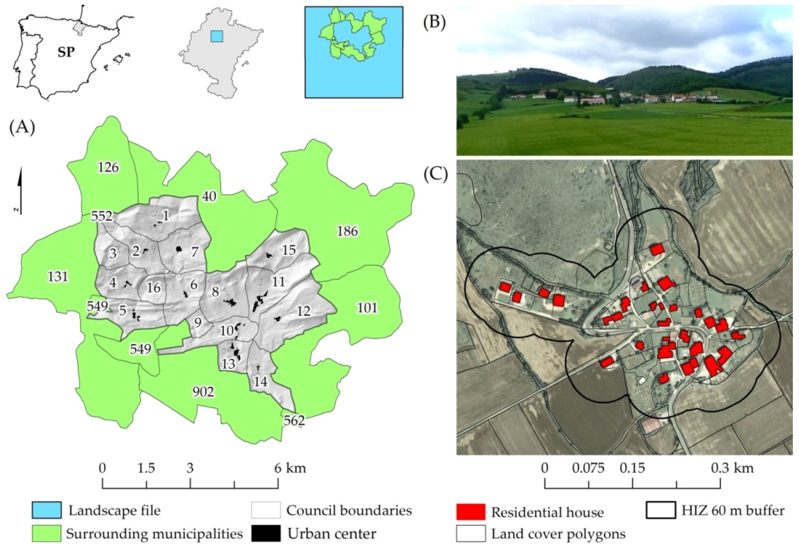
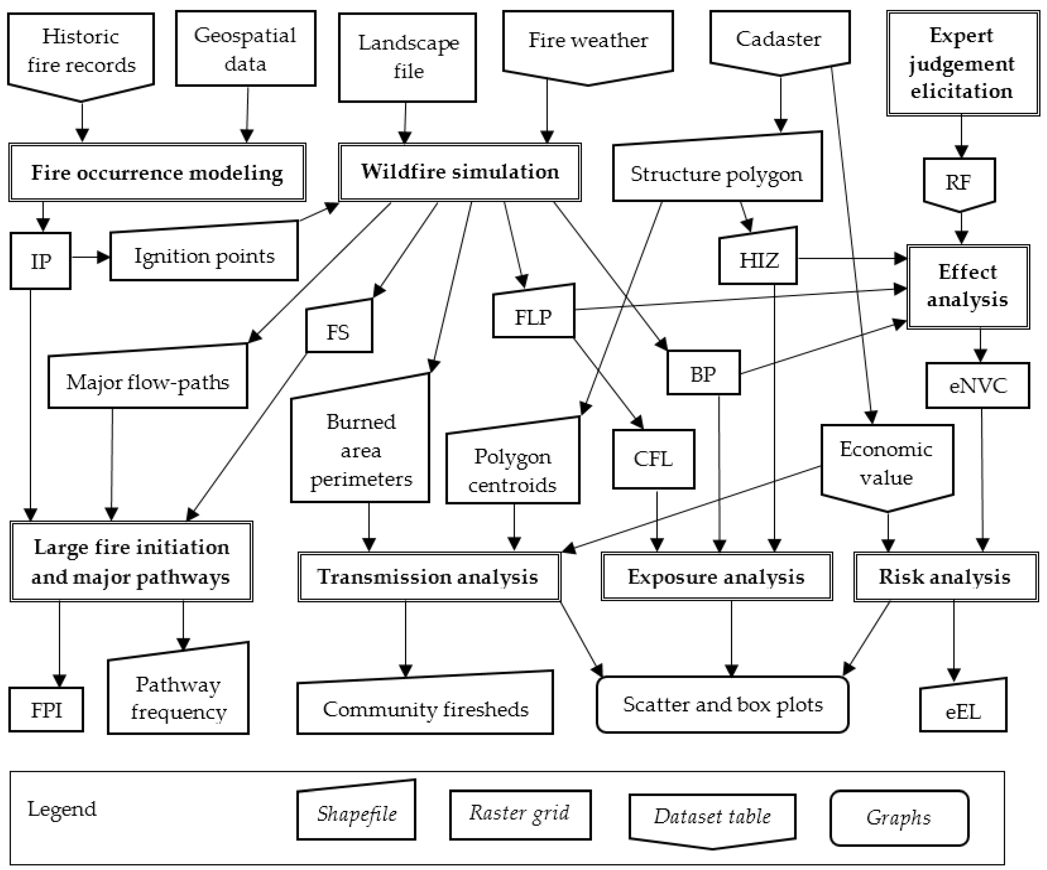
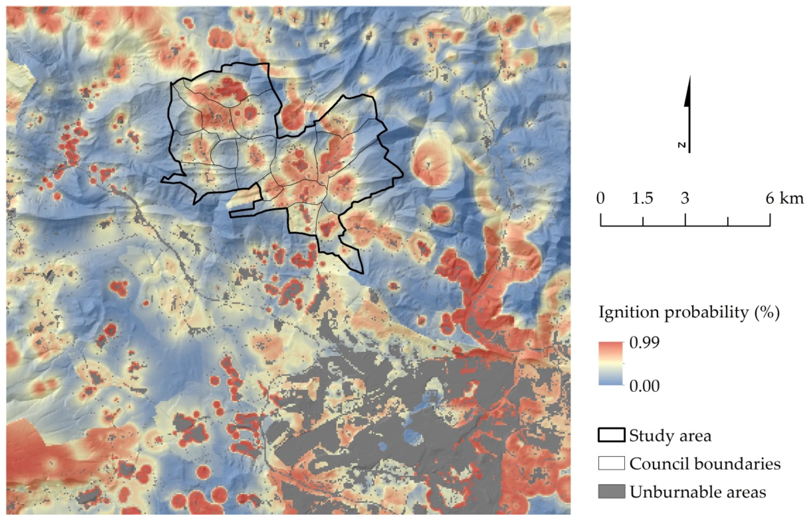
In this paper, we assess potential wildfire economic losses and transmission to residential houses in the rural communities of Juslapeña Valley, northern Spain. We used simulation modeling to map the source of wildfire exposure to communities and estimated the expected financial loss at the scale of individual structures. The simulation modeling incorporated a fine scale ignition probability grid developed from historical fire locations. Simulation outputs were used to estimate a number of exposure metrics, including burning probability and fire intensity. We estimated expected loss in the community using wildfire exposure metrics combined with a structure susceptibility function. The later was generated by a panel of local experts using an interactive structured communication technique. We also conducted a transmission analysis to delineate community firesheds and understand the source of wildfire exposure to communities. The methods provide a number of new ways to examine wildfire exposure to communities that can inform wildfire protection and improve fire resiliency in rural–urban interface areas in the Mediterranean region.
4. Discussion
The integration of biophysical fire modeling with susceptibility relationships derived from expert judgement provides a method to calculate expected financial loss to communities from potential wildfire events. Our analysis also demonstrated the tracking of burned areas in the communities to ignition locations, thus providing a linkage between wildland fuels and risk to communities. The results provided useful insights that can inform ignition prevention fuel management programs for reducing risk to communities [
72]. Transmission analysis allows the identification of sources of risk in terms of specific landowners within the study area [
39,
40]. The fireshed mapping defined the scale of risk to rural communities [
73] and delineated the area within which fuel treatments could be prioritized to reduce large-fire impacts [
37]. Coupling the fireshed with maps of exposure provides a wealth of information to inform the prioritization of wildfire management within the study area [
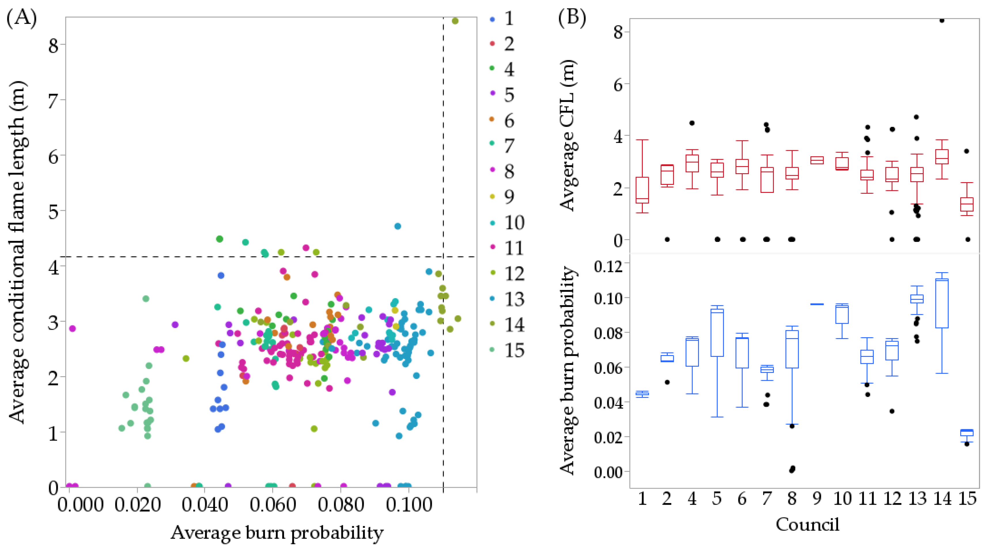
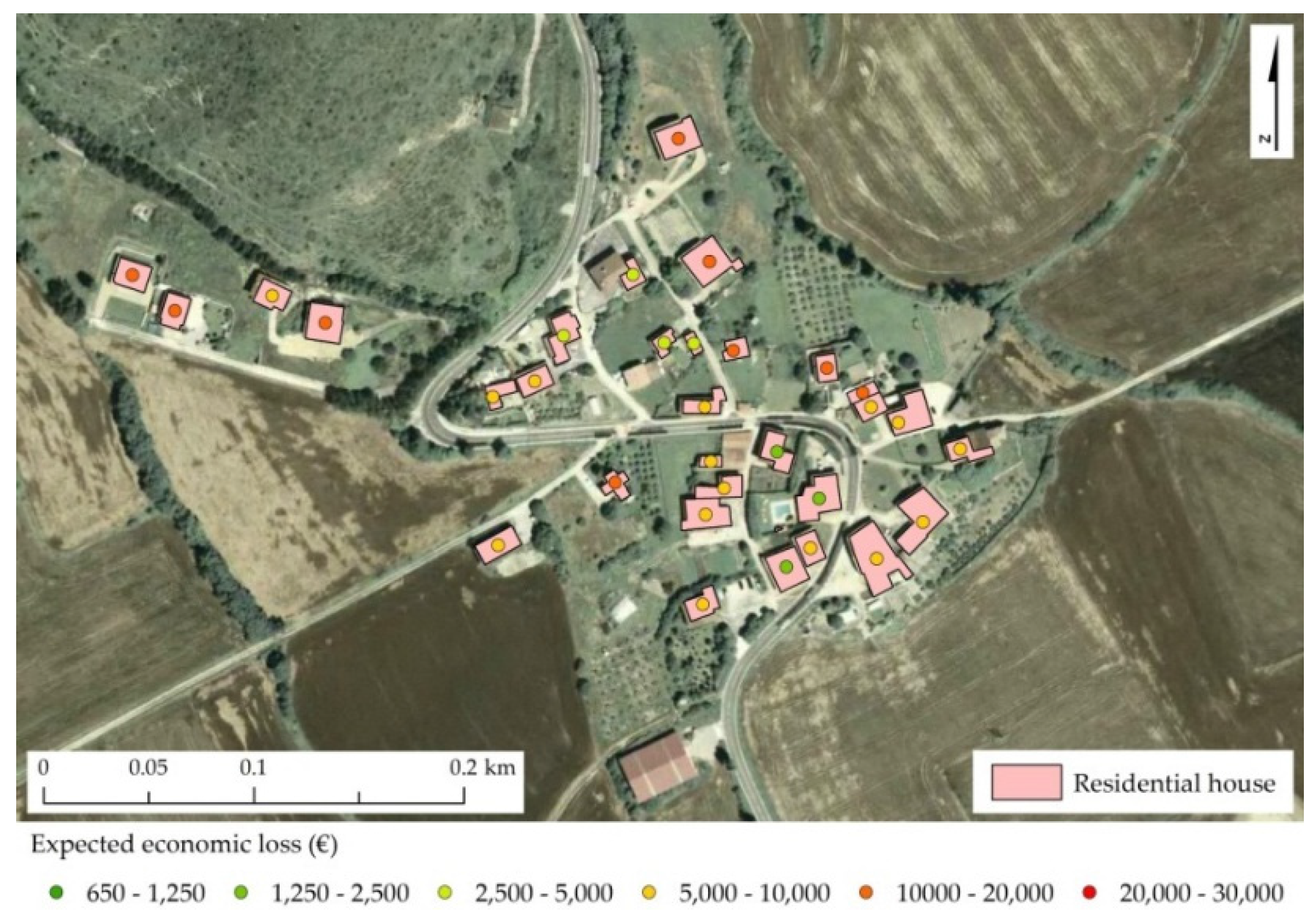
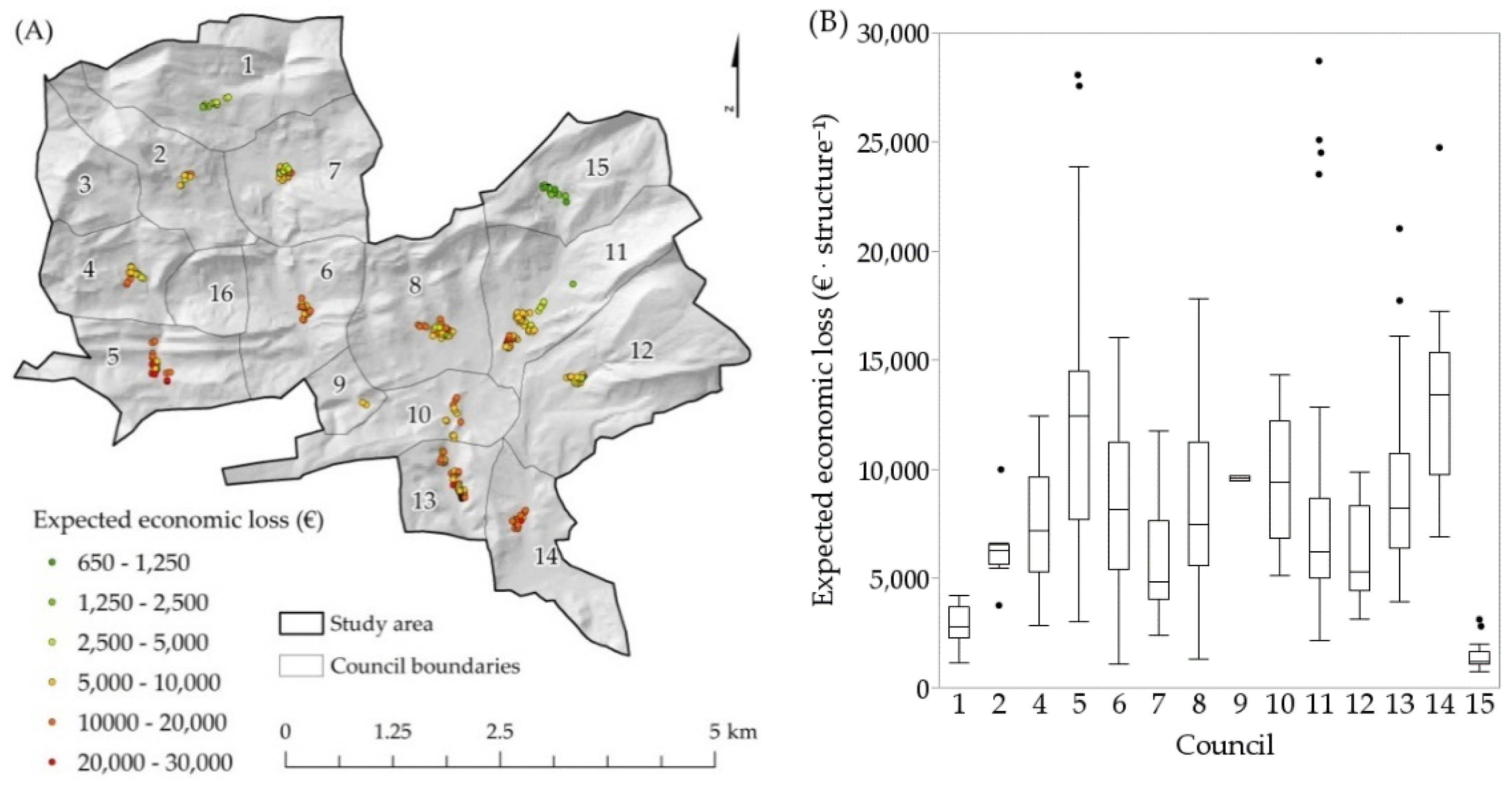
35]. Our fire risk quantitative assessment results showed a very strong structure-level spatial gradient in economic loss within and among the 14 councils in the Juslapeña Valley study area, and provided findings that are potentially useful for insurance companies and local landscape managers.
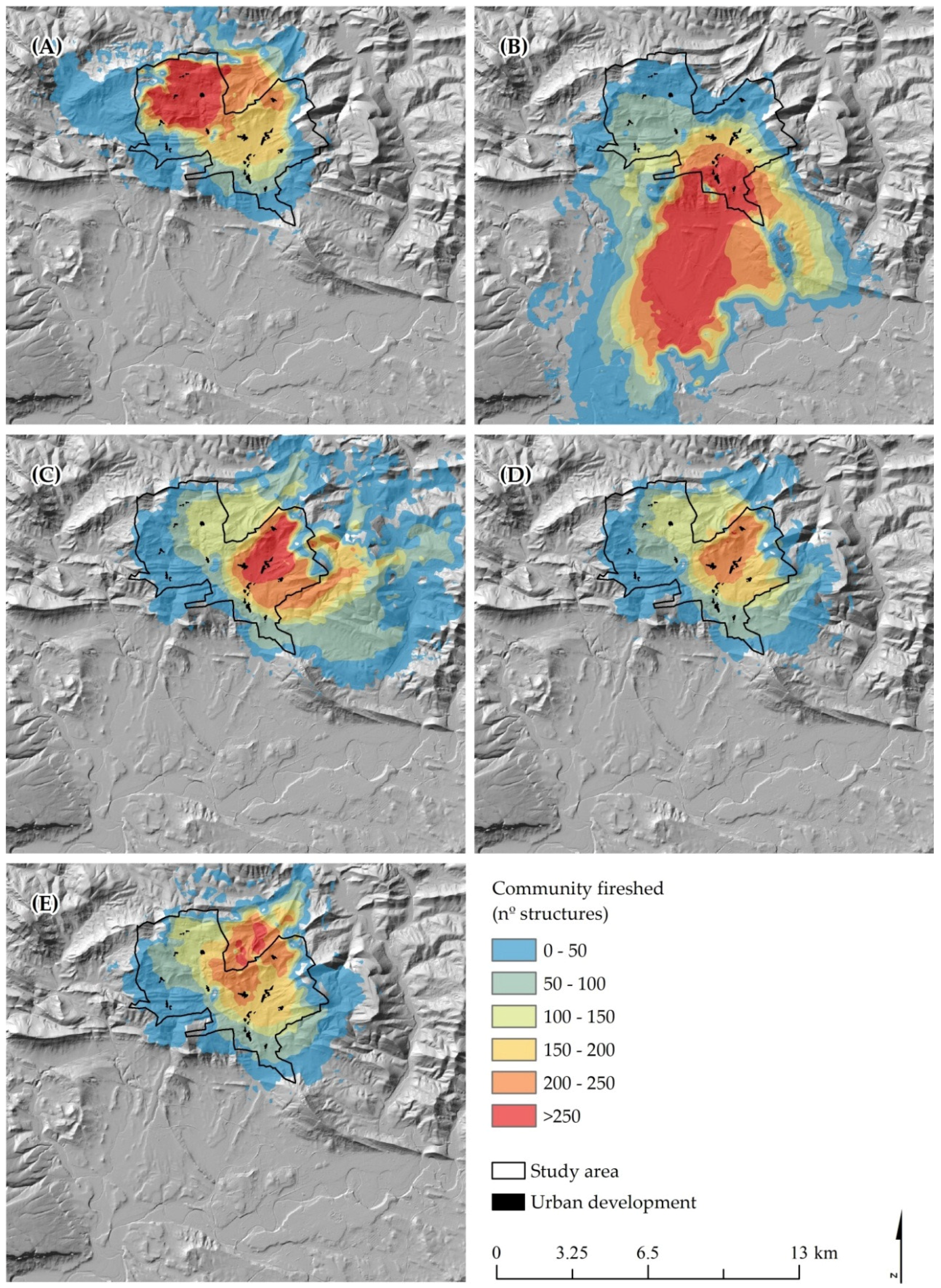
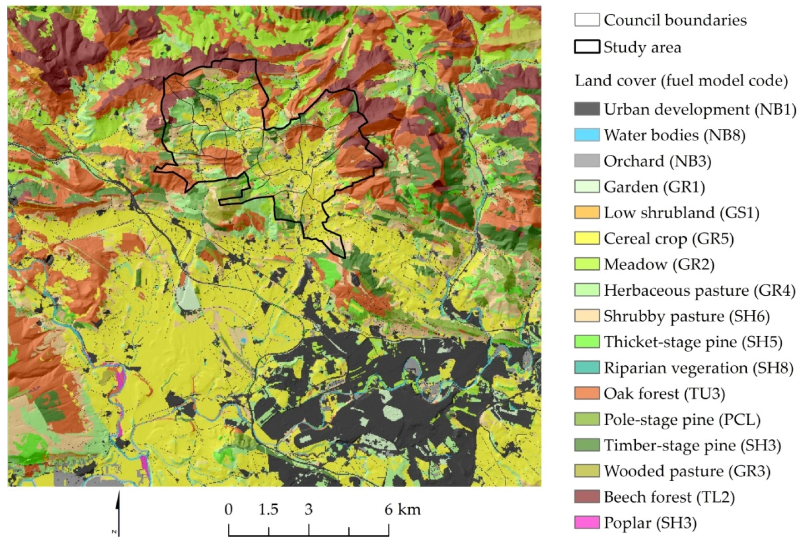
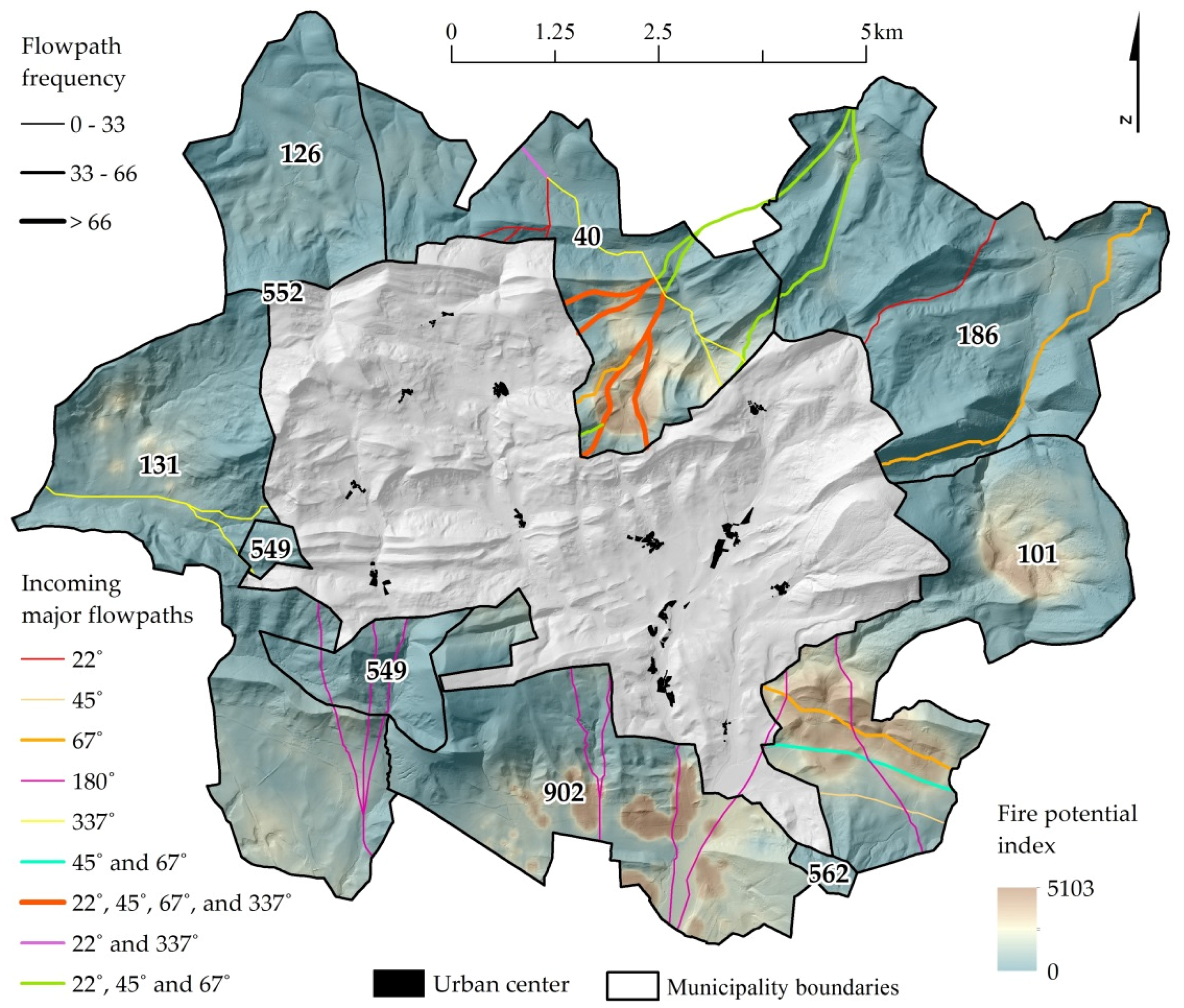
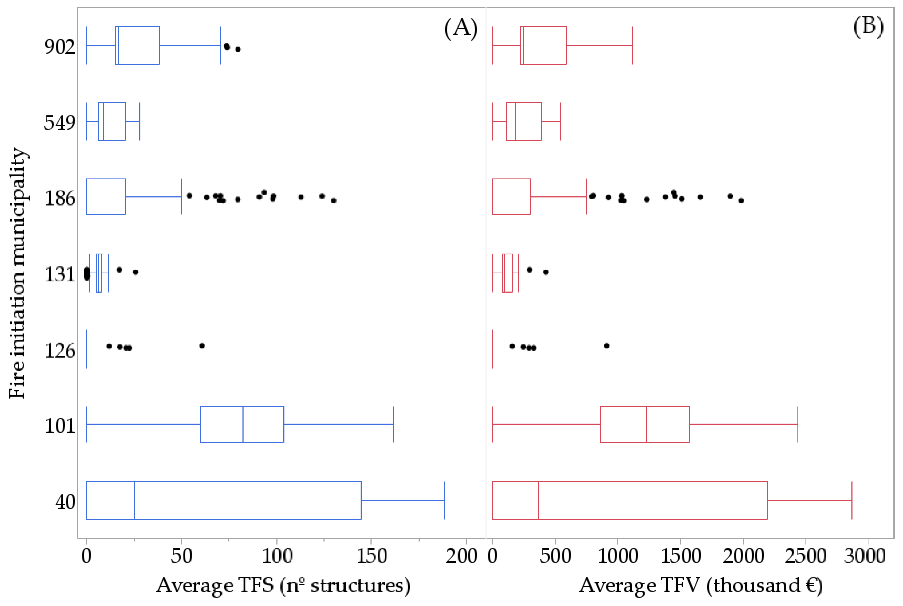
We identified high probability paths of incoming fire in central north and south east valley bottom flat areas [
62,
65], which were mainly located in neighboring municipalities 101 and 40. These two areas accounted for the bulk of the transmission as measured by the highest number of residential structures affected. Historically, fires frequently have impacted populated areas after spreading large distances from their ignition location, well beyond community wildfire planning boundaries, underscoring the importance of analyzing firesheds to minimize scale mismatches [
41] between the landscape planning and fire risk mitigation efforts [
73]. In fact, 67% of large fires (>100 ha) ignited in the surrounding municipalities reached target communities, and each of these fires affected 56 structures on average. Also, we found that the 180° wind direction fire weather scenario in particular resulted in fires spreading the longest distance from ignitions outside the study area administrative boundary (>8 km). Thus, collaborative planning efforts need to involve neighboring administrations and landowners (
Figure 7), and the significance of current land management in areas outside of target councils needs to be recognized for its potential to enhance wildfire risk. These practices include grazing, firewood collection in coppice oak forests and thinning in dense conifer plantations.
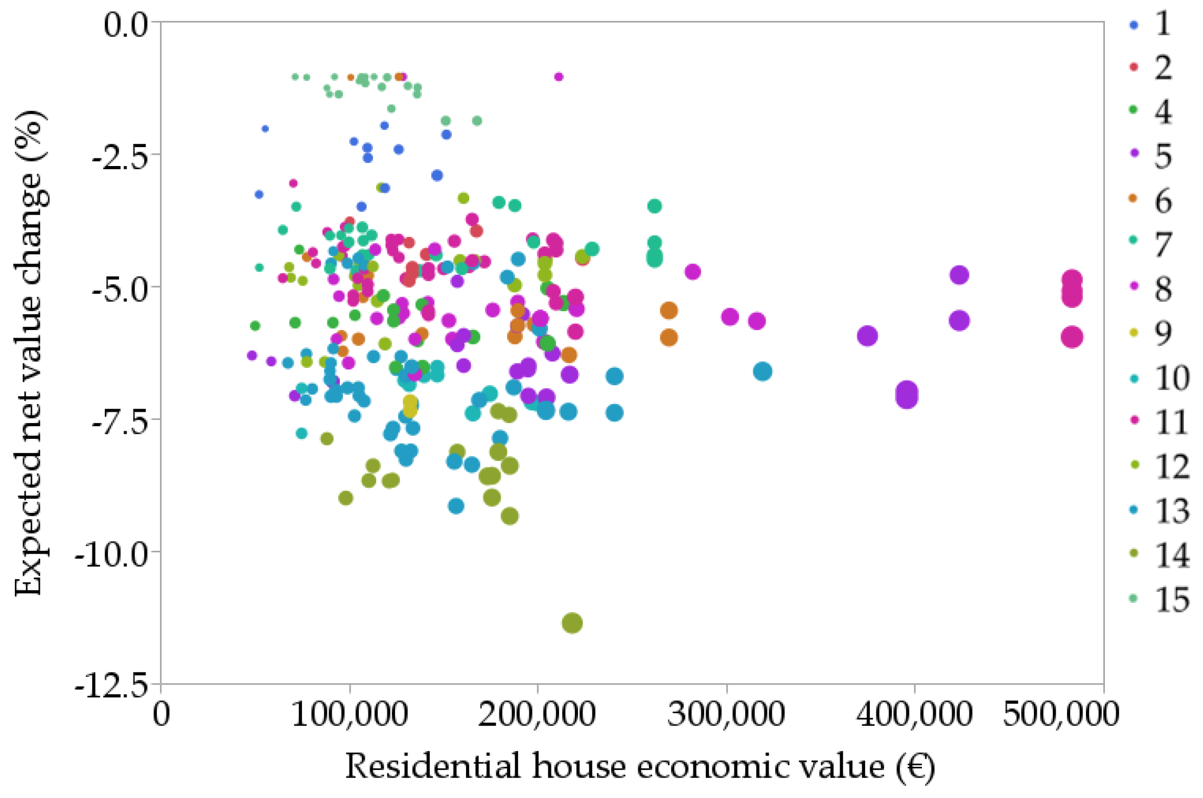
We contribute several new methods for exposure assessments within the Mediterranean region [
47,
72]. In particular, we used an ANN fire occurrence model to generate fire ignition input locations, and included an expert-defined response function for structure-scale assessment of potential economic losses. Although wildfire loss or benefit quantification is not possible for many socioeconomic values, a number of important services derived from forests can be represented with market pricing [
48]. Specifically, 72% of structures have estimated values ranging from 100 to 250 thousand euros, with relatively few (6%) having values >250 thousand euros. Rather than economic value, we found that spatial patterns of wildfire likelihood were the major causative risk factor, and thus fire occurrence spatiotemporal patterns in Mediterranean environments are especially important for fire prevention. ANN performed well and facilitated the generation of a high-resolution ignition probability grid. Understanding how fire weather and geospatial variables associated with anthropic activities can explain fire occurrence has been conducted in previous works [
74,
75].
This study highlighted the importance of fire spread modeling for risk assessment in Mediterranean environments where large fires spread through mosaics of fuel type and administrative jurisdiction [
32,
76,
77]. Urban interface classification based on housing density has been considered a key factor in structure loss and risk mitigation in some previous studies [
19,
78]. Indeed, scattered and occluded houses within wildlands usually present higher exposure levels from catastrophic fire events than densely populated urban development areas [
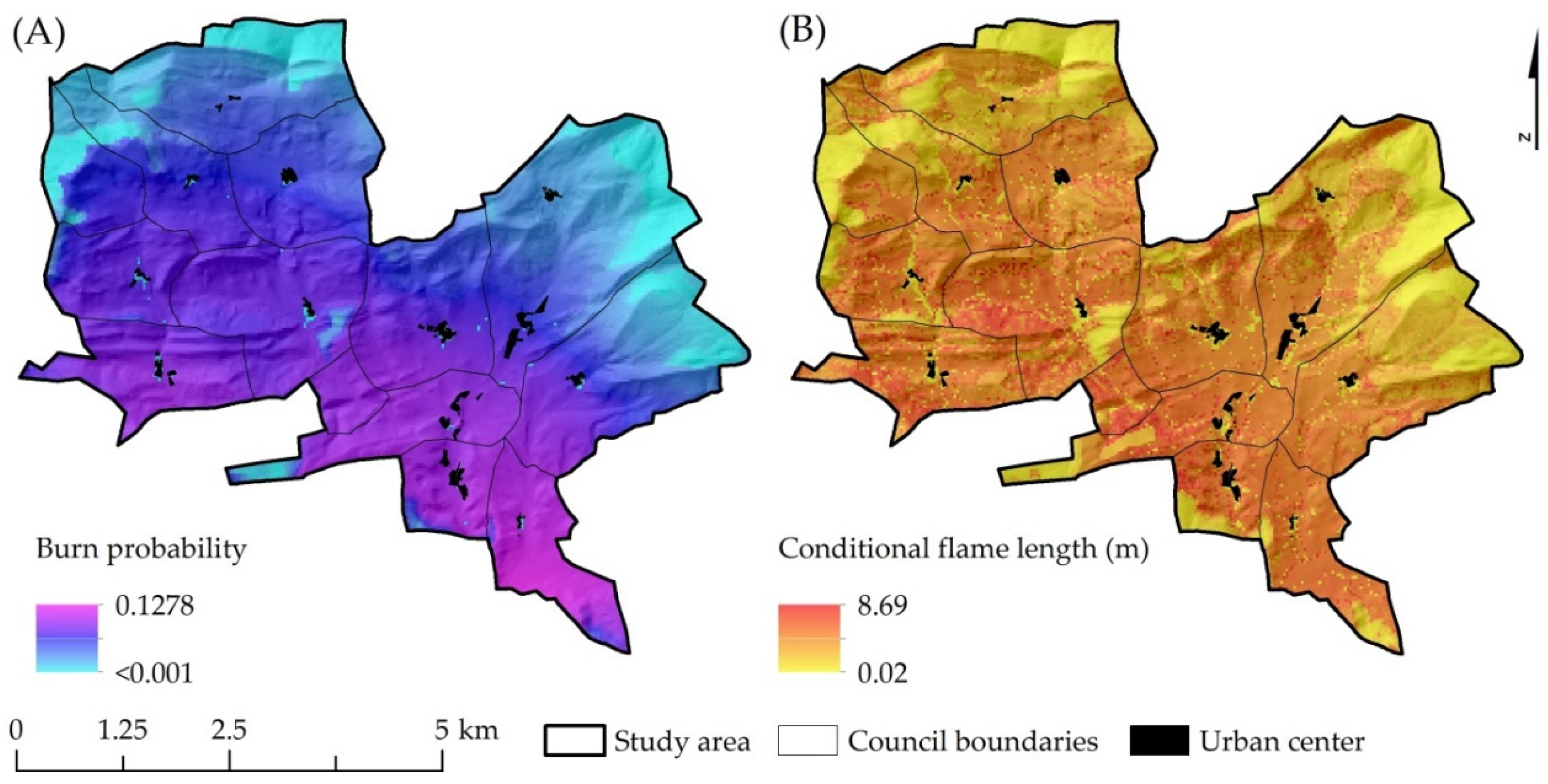
79]. However, structures at the periphery of communities usually incur higher losses since they intercept heading fires and associated embers showers (
Figure 13). Although most houses in the study area are built with fire-resistant designs and materials, and have cultivated orchards in the surroundings, exposure to ember showers makes them vulnerable to fire. Isolated dwellings in remote areas are hampered by poor access for ground-based suppression crews, a primary factor contributing to structure loss probability and human fatalities [
34]. Urban areas with fire-resistant structures and managed fuels in the HIZ can facilitate fire suppression opportunity, and help relocate residents to save zones during catastrophic fires events. The more typical situation is where developed areas become a resource sink for most of the firefighting resources, creating the potential for entrapment and accidents during mass evacuation during extreme fire events [
80].
Multiple management implications result from this study. First, the results provided useful insights to identify preferential areas for future urban development (e.g., high overall exposure area exclusion criteria) and to inform fire-resistant building design and material requirements. Integrating exposure from other natural hazards such as floods in river basin plains and rock falls or avalanches in mountainous areas is widely accepted as criteria for potential urban development, but fire risk is not accounted in most fire prone areas where catastrophic fires are frequent events (<30 years). In this regard, many southern EU governments concerned with WUI problems are now dictating specific public policies and municipal ordinances to promote community and homeowner involvement in hazardous fuel management. We present structure level risk assessment results that can contribute to risk reduction efforts by identifying where fuel treatment provides the highest benefits at the individual house level. Urban planning and fire managers have limited budgets to cover risk mitigation over thousands of scattered housing communities dispersed throughout fire prone landscapes, and quantitative risk assessment frameworks [
28,
33,
66] can help prioritize planning and investments as well help design specific spatial strategies [
81,
82].
Reducing structure susceptibility to fire [
34] in combination with fuel treatments, both in HIZ [
83] and strategically located areas on the landscape [
10,
35], are the key to mitigating wildfire risk to communities. Fuel treatments reduce potential fire intensity and spread rates by reducing surface and canopy fuel loadings and include a wide range of activities (prescribed burns, low pruning and low fuel load hedges, disrupting tree crown continuity and removing combustible material adjacent to structures) [
12,
84,
85]. Other measures such as the implementation of structure self-protection plans can alleviate extreme fire environments and improve suppression capabilities (e.g., water sprinklers and cannons). Apart from typical treatments in forest fuels and reducing structure susceptibility, other strategies that focus on reducing fire spread over herbaceous land cover could reduce the impacts of long-distance spreading fire events. For instance, we observed long-distance fire events originating in dryland croplands in the southern portion of the study area. By managing herbaceous fuels with extensive grazing in fenced pasture common lands [
86,
87], and using grass species with patchy growth habit on dryland hay meadows, wildfire spread and intensity could be reduced in these areas. However, implementation of supervised grazing after cereal harvesting that is needed to break fuel beds on the edges between mosaics of cultivated lands is nowadays complicated to implement [
88]. Currently, the major risk mitigation effort in agricultural areas is the prevention of ignitions during cereal harvesting operations from equipment, and increasing capabilities for more rapid response to ignitions if they do happen [
89].
We assume various sources of error in the models and input data, and results should be viewed as a local approximation of wildfire risk to residential houses in Juslapeña Valley given a large fire event in the study area. Modeling outcomes are conditioned to a specific configuration of extreme fire weather conditions, fuels, topography and the rural–urban interface spatial distribution of the study area. Although fuel models around structures did not differ much from the dominant types in the study area, elsewhere complex interface areas with trimming hedges among structures (e.g., cypress
Cupressus sempervirens L. hedges) might require a more detailed fuel characterization or various different response functions depending on secondary variables in addition to fire intensity. Community firesheds should be interpreted as a dynamic boundary that changes with assumptions about fire weather, and with existing spatial patterns of fuels as influenced by land management practices. The latter includes forest management practices, grazing practices and agricultural production. Moreover, structure loss is a complex process [
12], and is difficult to model at the landscape scale [
35]. As in other previous studies, we adopted an expert-defined response function to approximate fire effects at different fire intensities while acknowledging the margin of error [
36]. We also did not consider the potential effects of fire suppression that could affect our estimates of structure ignition, especially for low intensity fires with flame lengths <1.2 m [
90]. We also understand that structure economic value (conditioned to market changes) might not always be the best way to quantify real risk, due to the lack of correlation among the economic value and the social impact of structure loss on inhabitants. Focusing exclusively on economic criteria when setting treatment priorities might bias results to favor protection of the wealthy neighborhoods at the expense of lower priced homes, although in our study the value of homes did not substantially influence the results.
Further research is needed to better understand not only large fire transmission into the study area, but also the dominant transmission patterns at wider scales (e.g., regional and national), to understand how the study area is integrated into larger scale fire transmission patterns [
40]. Understanding major large fire movements would provide a wider perspective to identify the nodes or high priority areas in the landscape requiring investments in treatments. Identification of treatment polygons or stands in priority areas (or firesheds) can be facilitated with optimization models and trade-off analysis to maximize the reduction in risk to multiple values of interest, including structure loss, game species habitat improvement or conifer timber production [
91]. The risk assessment in this study should be considered as a preliminary step for mitigation and it does not necessarily reveal the optimal treatment allocation, especially considering that treating fuels at locations far from the urban interface can substantially slow large fire arrival [
35]. Analyzing multi-objective treatment strategies in rural–urban intermix fire-prone Mediterranean EU landscapes is challenging, although newer landscape planning tools that allow for integration of fire transmission have opened a wide range of new analytical approaches to analyze trade-offs between local hazard versus large-scale transmitted fire [
81].


 ,
, 


