Article

Increased Vegetation Greenness Aggravates Water Conflicts during Lasting and Intensifying Drought in the Poyang Lake Watershed, China

1
State Key Laboratory of Information Engineering in Surveying, Mapping and Remote Sensing, Wuhan University, Wuhan 430079, China
2
Institute of Geodesy and Geophysics, Chinese Academy of Sciences, Wuhan 430077, China
3
Key Laboratory of Monitoring and Estimate for Environment and Disaster of Hubei, Wuhan 430077, China
4
State Key Laboratory of Geodesy and Earth’s Dynamics, Wuhan 430077, China
5
Department of Geographical Science, University of Maryland, College Park, MD 20742, USA
6
Key Laboratory of Poyang Lake Wetland and Watershed Research, Ministry of Education, Jiangxi Normal University, Nanchang 330022, China
7
School of Electronic Information, Wuhan University, Wuhan 430072, China
8
Institute of Hydrobiology, Chinese Academy of Sciences, Wuhan 430071, China
*
Author to whom correspondence should be addressed.
Forests 2018, 9(1), 24; https://doi.org/10.3390/f9010024
Submission received: 7 November 2017 / Revised: 4 January 2018 / Accepted: 8 January 2018 / Published: 10 January 2018
(This article belongs to the Section Forest Ecology and Management)

Abstract

:
An increase in vegetation greenness can improve ecosystem productivity, but also reduce the water supply, creating the potential for conflicting water demands between ecosystems and humans. This problem has been well-assessed and is most evident in dry environments. However, in humid regions, the potential effects of vegetation greenness on water yields under drought conditions are not well understood. To address this gap, we focused on the Poyang Lake watershed in the humid region of southern China. Based on the Standardized Precipitation Evapotranspiration Index and a satellite-derived leaf area index dataset during the growing seasons of 1984 to 2013, several typical dry growing seasons were selected as the study conditions. An existing Water Supply Stress Index model was modified to investigate how the changes in vegetation greenness affected water yield and to explore potentially conflicting water demands between ecosystems and humans under drought conditions. Our results showed that an increase of 20–80% in vegetation greenness generally resulted in a reduction of 3–27% in water yield under drought conditions. Large reductions in water yield mainly were observed in forested areas due to large increases in forest greenness. Moreover, increased vegetation greenness caused a 2 to 3 times greater reduction in water yield during continuing and intensifying droughts than during a short moderate drought period. Thus, in this study, during continuing and intensifying droughts, increased vegetation greenness can cause or aggravate water conflicts in sub-watersheds with high forest cover and high human water demands. Therefore, given the increasing frequency of extreme climatic events, afforestation with a targeted approach should be implemented as it would provide the most benefits. In addition, selective harvesting in forested areas with high density could be an effective strategy to maintain water supply in humid regions.

1. Introduction

Over the last three to four decades, using the satellite-observed leaf area index (LAI) or normalized difference vegetation index (NDVI), several researchers have found that the vegetation greenness has been increasing in most parts of the Northern Hemisphere, especially in China [1,2,3]. Increased vegetation greenness, resulting from watershed management projects such as afforestation, reforestation, and improved agricultural practices, can improve terrestrial ecosystem productivity [4,5]. However, some studies have shown that vegetation greening can reduce watershed water yield (also referred to as streamflow or runoff); thus, it can reduce the water resources available for humans [1,6,7]. In fact, in arid and semi-arid areas, numerous studies have suggested that increased vegetation greenness can induce water demand conflicts, but few studies have investigated water yield responses on increased vegetation greenness in humid areas [4,8].
If unpolluted water within a region is less than that region’s demand by social-economic systems, a water crisis will arise [9]. Given the water crisis, prior studies of water yield responses on vegetation greening were concentrated on some water-limited arid and semi-arid regions [10,11,12]. For example, Feng et al. [13] showed that water yield decreased by 1–48 mm year−1 in 37% of the regions of the Loess Plateau of China due to revegetation. Feng et al. [4] noted that revegetation on the Loess Plateau was approaching the sustainable water resource limits based on different process-based ecosystem models. Moreover, due to climate change, the net primary productivity threshold could change within a range of 383–528 g C m−2 year−1 in the future [4]. Liu et al. [1] illustrated that vegetation greening decreased water yield at the large basin and national scales. They also suggested that, given the water crisis in dry regions, afforestation effects should focus on humid regions. Adoption of revegetation through afforestation to reverse ecosystem degradation in water-limited areas has been controversial in terms of water resources. However, have similar negative effects on the water supply also occurred under drought conditions in humid regions? Answering this question could inform watershed management projects and ensure efficient and effective management of sustainable water resources in these regions.
In humid regions, frequently occurring droughts, especially during growing seasons, could exacerbate over the next few decades in the context of global warming [5,14,15]. For example, large magnitude droughts caused by climate change could be clustered in the downstream area of the Yangtze River. Droughts could become more prolonged and intense due to global warming [15,16]. Such droughts threaten humid areas with water scarcity [17,18]. However, it is difficult to determine whether humid regions with increased vegetation greenness would result in water conflicts under drought conditions.
The Poyang Lake watershed is a typical humid area in the Southern China and includes the largest freshwater lake in China. It covers 9% of the entire Yangtze River basin and provides 17% of the water volume of the Yangtze River [19]. Since 2000, droughts have become more frequent, especially during autumn and summer. These droughts will continue to intensify in the future, placing tremendous pressure on water resources [17,20]. Meanwhile, the Poyang Lake watershed has witnessed severe soil erosion, primarily due to deforestation from the 1950s to 1980s [21]. To restore degraded ecosystem services, the Chinese government and local authorities initiate a series of watershed management projects, such as Mountain-River-Lake watershed management project and the Grain to Green programme [22,23]. These programmes have improved vegetation growth and contributed to vegetation greening [2]. According to the eighth national forest inventory, forest coverage in Jiangxi Province increased from 36% in 1985 to 56% in 2011. However, vegetation greening can decrease water yield and result in a water shortage in dry environments [1,24]. Therefore, the effects of vegetation greenness changes on water yield should be understood to assess the possibility of conflicting water demands occurring between ecosystems and humans under drought conditions in this watershed.
This study aims to assess the effects of the changes in vegetation greenness on water yield and the potentially conflicting demands for water linked to increased vegetation greenness under different intensities of growing-season drought in the Poyang Lake watershed from 1984 to 2013. First, the Standardized Precipitation Evapotranspiration Index (SPEI) was utilized to evaluate droughts of differing intensity and satellite-derived LAI data was used to detect vegetation greenness changes from 1984 to 2013. Second, the data for several typical dry growing seasons were selected to simulate the impact difference among different levels of drought. Third, in the typical growing season, we used a modified version of the Water Supply Stress Index (WaSSI) model to assess how the changes in vegetation greenness affect water yield under drought conditions in the study area. The modified version of WaSSI model along with the original LAI and land cover data while keeping the LAI and land cover data constant was used to conduct the two model simulations, respectively. Finally, the two model simulations were used to assess the effects of vegetation greenness changes on water yield. The conflicting demands for water between ecosystems and humans linked to increased vegetation greenness were explored.

2. Data and Methods

2.1. Study Area

The Poyang Lake watershed is in the middle reaches of the Yangtze River basin (Figure 1a). The area of the Poyang Lake watershed is 162,200 km2, and covers 97% of the Jiangxi provincial territory. The physical boundary of the Poyang Lake watershed is shown in Figure 1b, nearly matching the provincial administrative boundary. The Poyang Lake watershed consists of five main river sub-watersheds, including the Gan River (Gan), Fu River (Fu), Xin River (Xin), Rao River (Rao), and Xiu River (Xiu), and the Poyang Lake area (PL). Forest and cropland are the two main vegetation types in this watershed (Figure 1b), which has abundant forest resources and is also an important national rice-producing base in southern China. According to the Jiangxi Statistical Yearbooks, the population of the Province, comprising 3.5% of the country’s population, increased from 33.84 million to 45.42 million with a mean growth of 1.05% year−1 over the last fifteen years.
Poyang Lake watershed is a typical humid area of southern China. The humid subtropical climate in the Poyang Lake basin is characterized by the East and South Asian monsoons. The growing season extends from April to October. According to meteorological observation data collected from 2000 to 2013, the mean multiannual temperature and precipitation of the Poyang Lake basin were 18.03 °C and 1699.23 mm, respectively. The spatial and temporal distribution of precipitation was quite uneven, with the highest precipitation occurring between April and June, comprising 45–50% of the annual total precipitation.

2.2. Drought Assessment

The newly defined SPEI [25] for assessing drought intensity was computed based on a three-month time scale (SPEI_3). The SPEI_3 represents seasonal variation in droughts and is used to detect growing-season droughts. We used the SPEI_3 to detect growing-season droughts of four categories (mild, moderate, severe, and extreme) for the Poyang Lake watershed from 1984 to 2013, based on the SPEI_3 classification scheme [26] (Table S1).

2.3. Vegetation Greenness Changes Detection

Vegetation greenness is represented by satellite-derived LAI for the period of 1984 to 2013. As time series data, LAI reflects dynamic changes in vegetation growth and is a required variable in the modified WaSSI model when evaluating water yield [3,27].
The changes in growing-season LAI over the 30-year period were examined using the Mann-Kendall (MK) and Sen’s slope methods [28,29]. Sen’s slope measures the magnitude of a trend. A Sen’s slope value greater than zero indicates a rising trend and vice versa. The MK trend test is utilized to quantify the significance of trends in a time series. A standardized test statistic equaling or exceeding the confidence interval indicates a significant trend. In this study, several growing seasons with different drought intensities during a period with significant increase in LAI were selected for further analysis.

2.4. WaSSI Model and Its Modification

2.4.1. WaSSI Model

The WaSSI model is a process-based ecosystem model that can simulate water, energy and carbon cycles at a watershed scale. It has been successfully applied in many countries such as the U.S. and Mexico [27,30]. Compared to other process-based ecosystem models, the WaSSI model has two advantages: (1) it can simulate the water cycle in a changing climate, and (2) the input data for this model can be acquired more easily than those of other models [27].
The WaSSI model is run at monthly time step, and is driven by meteorological variables (precipitation, temperature), remotely sensed LAI, land cover types, and soil property data. The WaSSI model consists of hydrology and carbon modules. The hydrology module was used in this study to calculate water yield. The model simulates hydrologic processes (water yield, evapotranspiration (ET), and soil moisture storage) for each land cover type at the hydrological response unit (HRU) scale across the Poyang Lake watershed. As the core part within the hydrology module, ET is first approximated as a function of potential evapotranspiration (PET), LAI, and precipitation. Then, the actual ET is calculated by constraining this estimated value with the Sacramento Soil Moisture Accounting (SAC-SMA) model. Hydrologic processes including water yield infiltration and soil moisture storage are also estimated by algorithms in the SAC-SMA model. More details concerning the WaSSI model can be found in the WaSSI Ecosystem Services Model User Guide [27,31]. The WaSSI model, however, underestimated PET in the Poyang Lake watershed (Figure S1), and the ET algorithm, which determined the accuracy of water yield, did not take the influence of land cover heterogeneity into consideration [32]. Thus, we modified the WaSSI model to fit the study area.

2.4.2. Modifying the WaSSI Model

PET is calculated using the Harmon equation [30] as follows (Equation (1)):
PET = 0.1651 × N × K × ρ w × KPEC ,
where N is the number of days in the month; K is the daytime length (units of 12 h); ρ w is the mean saturated vapor density of the air every month ( g / m 3 ); and KPEC is the correction factor to adjust PET [33]. Compared to PET from the Moderate Resolution Imaging Spectroradiometer (MODIS) product [34], PET was underestimated by the original WaSSI model, and the value of KPEC in Equation (1) was adjusted to 1.2 in this study (Figure S1).
Moreover, only the influence of forest was considered in the ET algorithm of the original WaSSI model [27], not the influence of land cover heterogeneity, leading to overestimation in ET. In fact, land cover heterogeneity is high in the Poyang Lake watershed. Besides forest, cropland also plays an important role in the Poyang Lake watershed. Hence, ET in cropland should be estimated as well. Another empirical ET equation as a function of PET, LAI, and precipitation, derived from the cropland ecosystem-level ET based on eddy covariance [35], was added to this study.

2.5. Driving and Validation Data

The fundamental geography data for the WaSSI model include watershed boundary, basin river system, and Digital Elevation Model (DEM) data. DEM data with 90 m spatial resolution were obtained from the CGIAR-CSI SRTM 90 Database [36]. The DEM data and basin river system were the parameters for calculating the HRU, which is the driving parameter for the WaSSI model. The HRU was calculated using the Soil and Water Assessment Tool (SWAT) model within an ArcGIS platform [37]. According to the division standards of the Hydrologic Unit Code of the United States Geological Survey (USGS) and the optimum boundary method, the Poyang Lake watershed was divided into 351 HRUs, which belong to five main river sub-watersheds: the Gan River, Fu River, Xin River, Rao River, and Xiu River, as shown in Figure 1b, respectively [27,38]. Moreover, to run the WaSSI model, all the input data were re-scaled to the HRU watershed scale from raster data with various spatial resolutions.
Meteorological forcing data including monthly precipitation and temperature from 1984 to 2013 were obtained from the National Climate Centre of the China Meteorological Administration (CMA) at 19 stations in and around the Poyang Lake watershed. The Meteorological data were used to calculate the SPEI. In addition, all the meteorological data were spatially interpolated by inverse distance weighting (IDW), which were used for running the model.
The Global Inventory Modeling and Mapping Studies (GIMMS) LAI with a spatial resolution of 1/12 degree and a temporal resolution of 15 days from 1984 to 2013 were used for detecting the trend in vegetation and running the model. This product is derived from the third generation of the Normalized Difference Vegetation Index from the GIMMS group and an artificial neural network model [39]. The quality of the GIMMS LAI dataset has been assessed, and this dataset was suitable for applications in other disciplines [39]. In addition, the 15-day GIMMS LAI images were combined into monthly mean LAI composites for this study.
To characterize the land use and land cover change (LUCC) in the Poyang Lake watershed, we used the land cover maps for water yield simulation. Land information with a resolution of 500 m from 2001 to 2013 was provided by the MODIS Collection 5 Land Cover product (MCD12Q1) [40]. In addition, land information with a resolution of 500 m from 1992 using AVHRR data was provided by the global land cover dataset (IGBP-DISCover) (referred to as LUCC1992). All these are based on the International Geosphere-Biosphere Programme (IGBP) land cover classification system. The land cover types were further differentiated for the required land cover classification system, including cropland, deciduous forest, evergreen forest, mixed forest, grassland, shrub land, wetlands, open water, urban, and barren land (Figure 1b). In addition, the LUCC1992 and the MODIS land cover product in 2013 were used to evaluate the forest cover changes [41,42,43].
Soil data used for running the model were obtained from the gridded Global Soil Dataset [44]. This soil dataset, with a spatial resolution of 1km, was developed by the Land-Atmosphere Interaction Research Group at Sun Yat-sen University. It provides soil information including topsoil texture, drainage class, etc., to compute the related parameters of soil water content.
To assess the performance of the existing version of the WaSSI model, the annual MODIS PET product (MOD16A3) from 2000 to 2013 with a spatial resolution of 1km was used [45]. Furthermore, to compare the performance of modified WaSSI model at the monthly scale, the validation datasets included observed streamflow and actual ET. Observed streamflow (monthly water yield) from five gauging stations in the main tributaries of the Poyang Lake watershed were selected to assess model performance at the monthly scale (Figure 1b). The monthly streamflow data from 2000 to 2010 were obtained from the Jiangxi Provincial hydrological bureau. The observed actual ET data were collected from the eddy covariance (EC) flux site in Qianyanzhou from 2003 to 2004 (Figure 1b) [46].

2.6. Scenarios Designed

In this study, we designed two groups of scenarios to assess the effects of vegetation greenness on water yield using the modified WaSSI model (Table 1). Scenario I (S1) allowed all factors (LAI, LUCC, precipitation and temperature) to change from 1984 to 2013 as the true scene. Based on this scenario, the performance of the modified WaSSI model could be validated. Scenario II (S2) allowed the meteorological variables to change, but the LAI variable was fixed at the level of the 1984–1989 mean (i.e., the multi-year mean for an individual month), and the land cover data variable was fixed at the level of 1992. It was assumed that the vegetation greenness had no change during the study period. The relative difference (%) in water yield between the S1 (real change in vegetation greenness) simulation and S2 (unchanged vegetation greenness) simulations was used to evaluate the effects of vegetation greenness changes on water yield.
To explore potentially conflicting water demands between ecosystems and humans caused by vegetation greenness changes during different growing season drought intensities, the water yield in S1 and S2 was compared to the maximum water demand of socio-economic systems. The water conflict between ecosystems and humans was defined as when, in a given growing season, the maximum water demand by socio-economic systems exceeded the water yield over this watershed. Furthermore, the maximum water demand by socio-economic systems was defined as the water demand by socio-economic systems divided by the utilization ratio (the ratio of water consumption by socio-economic systems to the total amount of water resource in a region) of water resources over the Poyang Lake watershed. According to the bulletin published by the Jiangxi Province Ministry of Water Resources, surface water can meet 96% of the total water demands by socio-economic systems (including domestic use, agricultural irrigation, industry, fishing, and animal husbandry) in the Poyang Lake watershed; the other 4% comes from groundwater. Therefore, this study assumed that the water demand by socio-economic systems all came from surface water; groundwater was ignored. In addition, the 21.5% utilization ratio of water resources in the Jiangxi Province Ministry of Water Resources Bulletin was used in this study.

3. Results

3.1. Identifying Droughts with Differing Intensity

When the growing season SPEI_3 value was less than zero, a drought occurred. As shown in Figure 2a, growing season SPEI_3 averaged over the Poyang Lake watershed exhibited a downward trend with two periods of sharp increases: 2002–2007 and 2008–2013. Between 2002 and 2007, extensive growing season droughts (SPEI_3 < −0.5) occurred every three years. In contrast, extensive growing season droughts occurred every other year from 2008 to 2013. This indicates that the Poyang Lake watershed experienced a higher frequency of extensive growing season drought from 2008 to 2013 than that from 2002 to 2007.
According to the drought standard in Table S1, droughts of various categories were identified according to area-averaged SPEI_3 in the Poyang Lake watershed during the growing seasons of 1984–2013 (Figure 2b). Moderate drought occurred nine times during 1984–2013, with the 2008–2013 period having the most. From 2008 to 2013, moderate drought occurred throughout the entire growing season in 2009, while moderate drought occurred late in the growing season in 2013. Severe drought occurred just three times before 2008. In contrast, extreme drought occurred just one time during the growing seasons from 1984–2013: during the early growing season of 2011. This indicates that drought duration was prolonged and that drought intensity increased from 2008 to 2013, especially in the growing seasons of 2009, 2011, and 2013.
In addition, for six sub-watersheds, during the growing seasons of 2009 and 2011, all sub-watersheds were also hit by long-duration moderate droughts and short-duration extreme droughts, respectively (Figure S2). During the growing season of 2013, the six sub-watersheds experienced various intensities of drought, although the entire watershed experienced short-duration moderate drought (Figure 2b and Figure S2).

3.2. Variation of Vegetation Greenness

The trend of vegetation greenness for the Poyang Lake watershed was examined using the growing season LAI during the period from 1984 to 2013 (Figure 3). The watershed-averaged vegetation greenness as characterized by growing season LAI exhibited a significant increasing trend (ρ < 0.05) from 1984 to 2013, with one period of sharp increase: 2008–2013 (Figure 3). Vegetation restoration was most extensive in the period between 2008 and 2013, due to Mountain-River-Lake watershed management programme and the “Grain for Green” project in the study watershed [22,23].
To assess the effects of vegetation greenness changes on water yield under different intensities of drought, the dry growing seasons of 2009 (moderate drought throughout the entire growing season), 2011 (short-duration extreme drought), and 2013 (short-duration moderate drought) were used in this study (Figure 4). These were chosen because vegetation greenness significantly increased during the growing seasons of 2008–2013 (Figure 3). Meanwhile, the Poyang Lake watershed experienced more frequent and extensive droughts of various intensities during the growing season of 2008–2013 (Figure 2).
Figure 4 shows the changes in vegetation greenness as characterized by LAI for the dry growing seasons of 2009, 2011 and 2013 with reference to the mean growing season LAI from 1984–1989. Large areas of the Poyang Lake watershed exhibited increases of 20–80% in growing season LAI except for the southern and northern tips of the Poyang Lake watershed during the three growing seasons with droughts of various intensity. Pixels increasing in LAI accounted for 92.6%, 95.3% and 92.2% of the total during the growing seasons of 2009, 2011 and 2013, respectively. This indicated that although the Poyang Lake watershed experienced droughts of various intensities, large areas of the watershed exhibited increases in vegetation greenness.
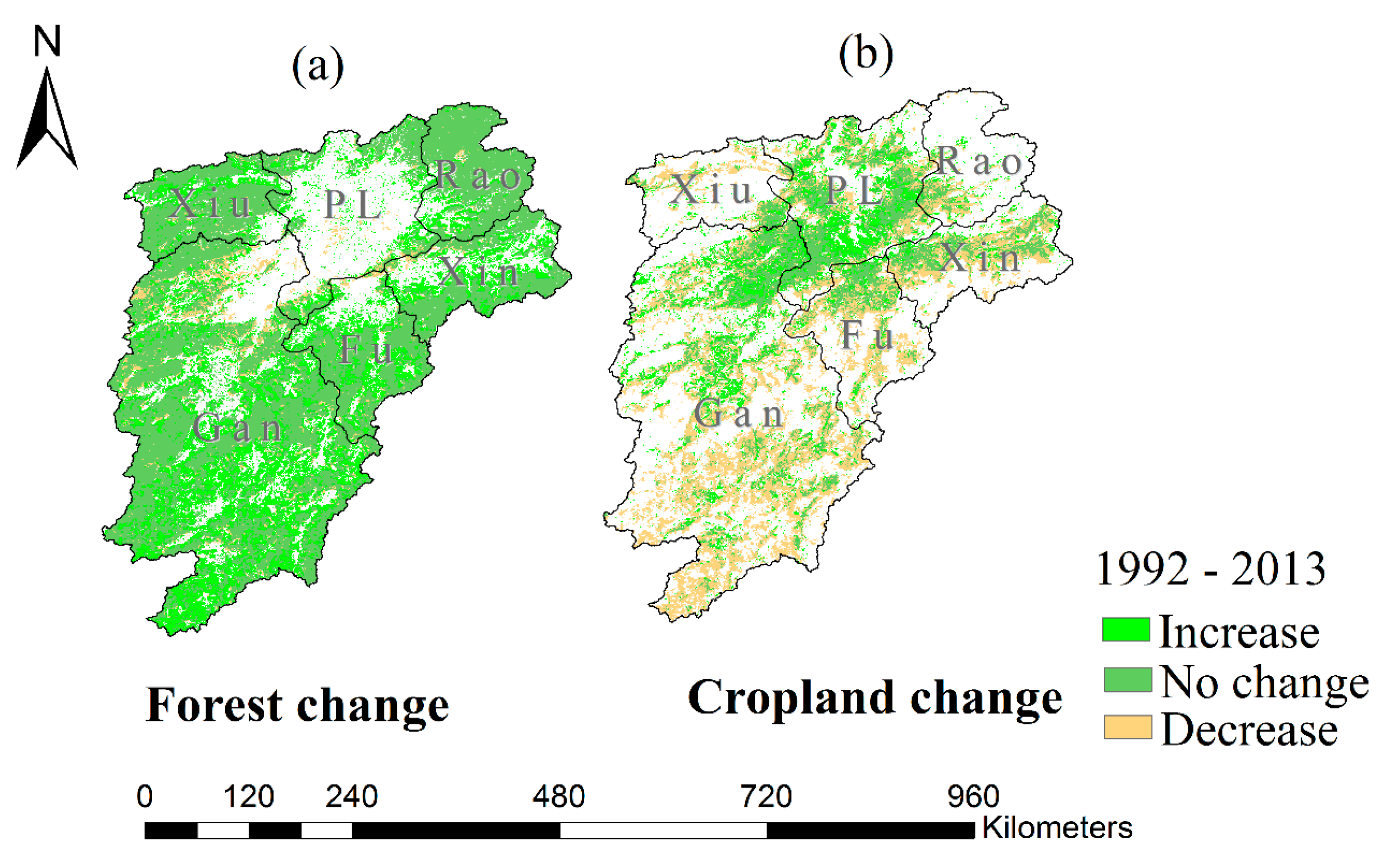
The spatial distribution of increased vegetation greenness was similar, while their magnitudes varied under the different intensities of drought conditions. Compared to the mean growing season LAI during 1984–1989, the areas with an increase of 40–80% in growing season LAI accounted for 10.2% of the entire watershed in 2009, which was less than that in 2013. The reason is that the watershed experienced longer duration of moderate drought in the growing season of 2009 than in that of 2013. The areas with large increase (40–80%) in growing season LAI were sporadically distributed in the middle reaches of the Gan River, the upper reaches of the Xiu River, and portions of the Poyang Lake area. In contrast, the areas with large increased vegetation greenness during the growing season of 2011 were twice that seen during moderate drought because the Poyang Lake watershed experienced a short-duration extreme drought during the early growing season of 2011 (Figure 2b). This was also observed in the middle reaches of the Gan River, the middle and lower reaches of the Fu Rive, and portions of the Poyang Lake area, because these are the key forest areas in the watershed management programmes. The watershed management programmes aim to implement afforestation and reforestation, resulting in an obvious increase in forest cover in these areas (Figure 5a). In addition, the watershed management programmes also improved agricultural management practices in these regions, resulting in an obvious increase in cropland cover in portions of the Poyang Lake area, leading to large increases in vegetation greenness in this area (Figure 5b).

3.3. Validating the Modified WaSSI Model

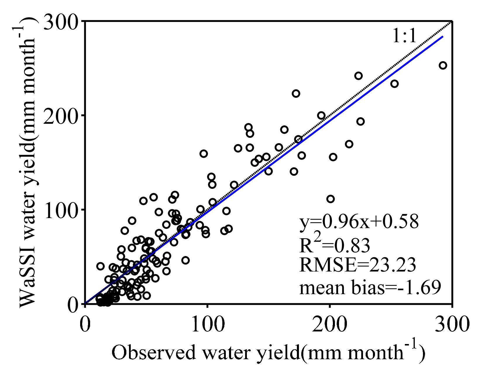
In this study, the measured actual ET from the EC flux site and water yield (runoff) data from the five river sub-watersheds were collected to evaluate the ability of the modified WaSSI model in simulating actual ET and water yield, respectively.
The scatter plot of the measured actual ET vs. modelled actual ET (2003–2004) provides evidence for the capability of the modified WaSSI model to simulate actual ET (Figure 6). The modelled actual ET was related to the observed actual ET with a coefficient of determination (R2) of 0.83. Moreover, the observed and the modelled actual ET were distributed along the 1:1 line with a mean bias of −2.03 mm month−1 and a root mean square error (RMSE) of 15.15 mm month−1.
Comparisons between the modeled water yield and observed water yield for the Poyang Lake watershed from 2000 to 2010 (Figure 7) indicated that the modified WaSSI model performed well as judged by the model statistics (R2 = 0.83; RMSE = 23.23 mm month−1). The mean bias of the modelled water yield was −1.69 mm month−1, suggesting that the model slightly underestimated water yield in this watershed. This result is reasonable as the model failed to consider the effect of dams on water yield. Overall, the model simulated the monthly water yield well.

3.4. Effects of Vegetation Greenness Changes on Water Yield under Different Intensities of Drought at a Spatial Scale

The modified WaSSI model was used to simulate the S1 (real change in vegetation greenness) and S2 (keeping vegetation greenness unchanged) scenarios. Then, the differences in water yield between the two simulations were used to examine the effects of vegetation greenness changes on the magnitude and spatial patterns of water yield under different intensities of growing season droughts (Figure 8). Decreases in vegetation greenness under different drought intensities generally led to an increase in water yield, which was discovered in a few areas. However, the effects of increased vegetation greenness on the magnitudes and spatial patterns of water yield varied under different drought intensities. During a short-duration extreme drought or a long-duration moderate drought, the decreases in water yield resulting from increased vegetation greenness were two to three times greater than that during a short-duration moderate drought. In addition, there were larger variations in the differences between the forest and cropland areas due to the vegetation characteristics and human influences under different drought intensities. Large decreases in water yield were mainly observed in forest areas where forest greenness largely increased.
For a few areas with increases in vegetation greenness, abnormal differences in water yield between the two simulations were observed under different drought intensities. For example, an increase of more than 18% in water yield was observed in the lower reaches of the Gan River and the portions of the Poyang Lake area with much cropland cover, while a reduction of 18–65% in water yield was observed in the lower reaches of the Gan River with much cropland cover. This indicated that the effects of increased cropland greenness on water yield were complex under different intensities of drought, due to the effects of human activities including irrigation.
However, in most areas with increases in vegetation greenness, an increase of 20–80% in vegetation greenness generally led to a reduction of 3–27% in water yield under different intensities of drought (Figure 4 and Figure 8). A large decrease in water yield (9–27%) was observed in the middle reaches of the Xiu River with large increased forest greenness (20–60%) during the long-duration moderate drought (the growing season of 2009). During the short-duration moderate drought (the growing season of 2013), a reduction of less than 9% in water yield was observed in most areas with increased vegetation greenness. A large reduction in water yield (3–9%) was mainly observed in the upper and middle reaches of the Gan River with an increase of 20–60% in forest greenness. Furthermore, during an extreme drought, a large reduction in water yield (9–27%) was observed in the middle and the upper reaches of the Gan River with a large increase in forest greenness (40–80%) during the growing season of 2011. This indicated that increased vegetation greenness may lead to a greater reduction in water yield under a long-duration moderate drought or a short-duration extreme drought.

3.5. Effects of Greenness Change on Water Yield under Different Intensities of Drought at Watershed and Large Sub-Watershed Scales

The differences in water yield between the two simulations (S1–S2) were used to examine the effects of vegetation greenness changes on water yield under growing season drought conditions at watershed and large sub-watershed scales (Table 2).
The differences in watershed-averaged water yield from both simulations exhibited decreases in the dry growing season of 2009, 2011, and 2013, respectively (Table 2). The decreases in watershed-averaged water yield resulting from increases in vegetation greenness in dry growing season of 2009 and 2011 were higher than those in the growing season of 2013. Meanwhile, the Poyang Lake watershed experienced a long-duration moderate drought, a short-duration extreme drought, and a short-duration moderate drought during the growing seasons of 2009, 2011, and 2013, respectively. Our results indicated that at the watershed scale, increased vegetation greenness caused reduction in water yield under different intensities of drought, and the watershed-averaged water yield reduction during long long-duration moderate drought or short-duration extreme drought was two times larger than that during short-duration moderate drought.
We further examined the effects of vegetation greenness changes on water yield at large sub-watershed scales (Table 2). The growing season mean LAI averaged at the six sub-watersheds exhibited increases under different intensities of drought, while the growing season water yield from both simulations (S1 minus S2) exhibited decreases. This indicated that the increased vegetation greenness had negative effects on water yield at the large sub-watershed scale under different intensities of drought.
During the growing seasons of 2009 and 2011, all six sub-watersheds experienced long-duration moderate droughts and short-duration extreme droughts, respectively (Figure S2). Under these drought conditions, the water yield reduction coincided with increased vegetation greenness. The strongest negative differences in growing season water yield between the two simulations were observed in the Xiu sub-watershed and the Fu sub-watershed during the growing season of 2009 and 2011, due to the largest increases in LAI in the Xiu sub-watershed and the Fu sub-watershed, respectively. In contrast, during the dry growing season of 2013, because the drought duration and drought intensity in the Fu sub-watershed were more than that in the Poyang Lake area (Figure S2), the strongest negative difference in growing season water yield (−5%) between the two simulations was observed in the Fu sub-watershed, where the increased LAI was 20%. In the Poyang Lake area, the largest increase in the LAI (31.3%), resulted in a 2% reduction in water yield. This result indicates that the area-averaged water yield would be further reduced during continuing and intensifying drought.
Overall, our results show that at the watershed and large sub-watershed scales, increased vegetation greenness had negative effects on growing season water yield during different intensities of drought. Moreover, during continuing and intensifying drought, increased vegetation greenness would lead to twofold greater reductions in water yield than during short-duration moderate drought.

3.6. Potential Water Demand Conflicts between Ecosystems and Humans

According to the Water Resources bulletin published by Jiangxi Province Ministry (http://www.jxsl.gov.cn/), the annual water consumption by socio-economic systems in the Poyang Lake watershed increased from 72.99 to 96.99 billion cubic metres (bcm) from 1999 to 2013 with a mean growth rate of 2% year−1. Meanwhile, increases in vegetation greenness could reduce water yield in the Poyang Lake watershed under different intensities of drought. Therefore, potential water demand conflicts between ecosystems and humans were explored under growing season drought conditions.
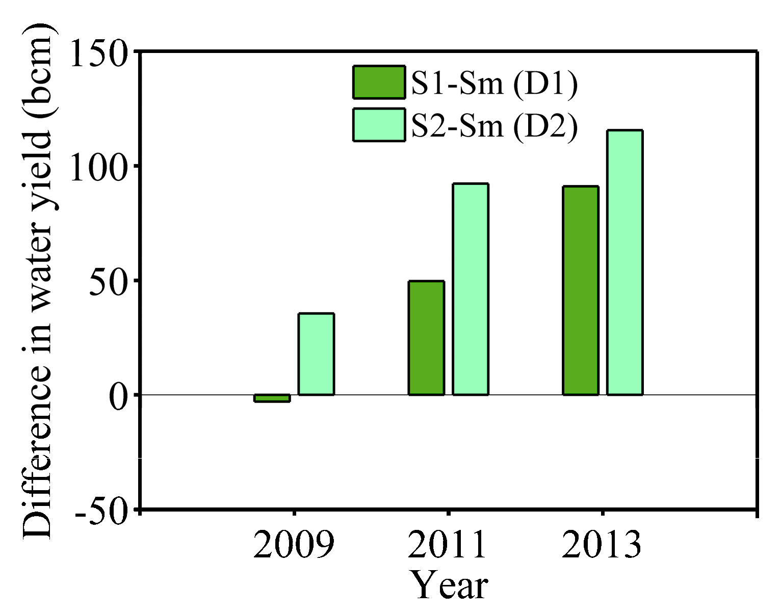
To assess conflicting demands for water between ecosystems and humans resulting from increased vegetation greenness, a comparison of maximum water demand by socio-economic systems (Sm), water yield in S1 (real change in vegetation greenness) and S2 (unchanged vegetation greenness) was explored for the Poyang Lake watershed and six sub watersheds of different intensities of drought (Figure 9 and Figure 10). On the one hand, when the difference between S1 and Sm (D1) is less than zero and the difference between S2 and Sm (D2) is greater than zero, increased vegetation greenness may cause conflicting demands for water between ecosystems and humans. In addition, if the D1 and D2 are both less than zero and the D1 is less than D2, increased vegetation greenness may aggravate conflicting demands for water between ecosystems and humans.
At the averaged-watershed scale, the D2 was positive in the Poyang Lake watershed, while the D1 was negative, indicating that increased vegetation greenness may have cause conflicting water demands between ecosystems and humans during the dry growing season of 2009. However, during the dry growing season of 2011 and 2013, D1 and D2 were both positive, which indicates that no water conflict occurred during the growing season of 2011 and 2013. The reason was that the Poyang Lake watershed experienced long-duration moderate drought during the growing season drought in 2009, while it experienced short-duration moderate and extreme drought during the growing season of 2011 and 2013, respectively (Figure 2b). The reduction in water yield resulting from increased vegetation greenness during the growing season of 2009 was greater than that during the growing season of 2011 and 2013 (Table 2). These results show that increased vegetation greenness could cause water conflict during prolonged moderate drought at the watershed scale.
We further estimated the water conflict between ecosystems and humans resulting from increased vegetation greenness under different drought intensities at the large sub-watershed scale (Figure 10). During the growing season of 2009, the increased vegetation greenness could cause water conflict in the Gan sub-watershed, where D1 was −9.4 bcm and D2 was 2.1 bcm. The increased vegetation greenness could aggravate water conflict in the Poyang Lake area (D1< D2 < 0). During the growing season of 2011, the increased vegetation greenness could aggravate water conflict in the Gan sub-watershed and the Poyang Lake area, while the situation could be further worsened in the Gan sub-watershed (D1 = −33.4 bcm). Meanwhile, the Fu sub-watershed could experience water conflict as well (D1 = −8.8 bcm, D2 = 3.6 bcm). During the growing season of 2013, D1 (−12.9 bcm) was slightly less than D2 (−11.5 bcm) in the Poyang Lake area, which indicated that the increased vegetation greenness somewhat aggravated water conflict.
It can be seen that water conflict between ecosystems and humans resulting from increased vegetation greenness was mainly observed in the Gan sub-watershed, the Fu sub-watershed and the Poyang Lake area during the growing season of 2009 and 2011. The reason was that these sub-watersheds experienced long-duration moderate droughts and extreme droughts during the growing seasons of 2009 and 2011, respectively. The decreases in water yield resulting from increased vegetation greenness were large in these sub-watersheds under these drought conditions. Meanwhile, the water demands from humans in these sub-watersheds were greater than those in the other sub-watersheds (Figure 11). We also found that the increased vegetation greenness in the Gan and Fu sub-watersheds with much forest cover had greater effects on water conflicts than that in the Poyang Lake area with much cropland cover (Figure 10 and Table S2). This was because large reductions in water yield related to large increases in forest greenness were observed in the two sub-watersheds (Figure 8).
Therefore, our results indicated that increased vegetation greenness could cause or aggravate water conflict between ecosystems and humans in the sub-watersheds with large increases in forest greenness and high human water demands under lasting and intensifying drought conditions.

4. Discussion

Several studies have suggested that vegetation greenness has been increasing over most areas of China and even many parts of the Northern Hemisphere over the last three decades [1,2,47]. Similarly, our results show that notable drying trends in the Poyang Lake watershed occurred during the time series from 1984 to 2013. However, vegetation greenness continued to increase in the Poyang Lake watershed. The reason is that the soil and the shallow groundwater has a positive effect on new vegetation growth because the Poyang Lake watershed is in a humid region where the shallow groundwater is plentiful [48] and where the watershed management projects were effective [2,22].
The magnitude and spatial distribution of increased vegetation greenness varied under different drought intensities such as during the dry growing seasons of 2009, 2011, and 2013. However, increased vegetation greenness (20–80%) was distributed in both cropland and forest areas. For example, in the parts of crop areas such as the Poyang Lake area, successful watershed management, including the use of efficient irrigation and chemical fertilizers, and high yield crops were responsible for the cropland greenness increases. Meanwhile, in forested areas, such as the middle reaches of the Gan River, the middle and lower reaches of the Fu River, and the upper reaches of the Xiu River, afforestation/reforestation contributed to forest greenness increases [22]. In addition, the few areas of vegetation greenness decrease were due to the influence of droughts during the dry growing seasons [47].
The modified WaSSI model was effective for the Poyang Lake watershed. Our model simulations showed that increases in vegetation greenness generally caused reductions in water yield at different scales. Furthermore, under lasting and intensifying drought conditions, the increased vegetation greenness would lead to two to three times greater reductions in water yield than that during a short-duration moderate drought. The reason was that increases in vegetation transpiration and evaporation resulting from increased greenness during lasting and intensifying drought were larger than that during a short-duration moderate drought (Figure S3). Lasting and intensifying drought can result in more incoming solar radiation and therefore can accelerate ecosystem processes (e.g., ET) in humid region [49]. At a spatial scale, an increase of 20–80% in vegetation greenness generally caused a decrease of 3–27% in water yield under drought conditions. However, the effects of increased cropland greenness on water yield were complex under different drought conditions. For example, an increase in water yield resulting from an increase in vegetation greenness was observed in the lower reaches of the Gan River and the portions of the Poyang Lake area with much cropland cover. The reason was that decreases in cropland productivity and actual ET resulting from stomatal closure could lead to water yield increases under droughts in cropland areas [50,51,52]. However, for a few areas with increases in cropland greenness, a reduction of 18–65% in water yield was observed. The reason was that these regions have large irrigation areas (more than 10,000 ha) [53], the agricultural crops would continue the growth under drought condition, and the evapotranspiration would increase, which would lead to large reduction in water yield (Figure S3). Comparably, increases in forest greenness generally lead to decreases in water yield. Especially in the core areas of the afforestation and reforestation projects, an increase of 20–80% in vegetation could lead to a reduction of 9–27% in water yield under lasting and intensifying drought conditions. The reason was that tree species have high water use efficiency but low maximal rates of photosynthesis for maintaining growth under these drought conditions, leading to water consumption and thereby water yield reduction [54,55].
We also suggest that increases in vegetation greenness could lead to water conflict during prolonged moderate drought at the watershed scale. Moreover, at the large sub-watershed scale, the water conflict was further worsened in the sub-watersheds with large increases in forest greenness and high human water demands during lasting and intensifying drought. In contrast, during short-duration moderate drought, the Fu sub-watershed with a large increase in forest greenness may potentially cause water conflict, while areas such as the Poyang Lake area with a large increase in cropland greenness slightly aggravated water conflict. Therefore, increased forest greenness linked to afforestation or reforestation can become a problem in humid areas such as the Poyang Lake watershed with abundant water due to the exacerbated climate abnormality (droughts), which is consistent with the findings of a previous study [24]. In addition, Zheng et al. [24] did not quantitatively assess the result, but this study quantitatively estimated the consequences.
Hence, watershed management needs to focus on balancing afforestation and water yield, and handling potentially conflicting water demands between ecosystems and humans under lasting and intensifying drought conditions in the Poyang Lake watershed. Although artificial forest such as subtropical coniferous forest could consume much water [24], afforestation/reforestation can restore ecosystem degradation, by controlling soil erosion and improving carbon sinks, and can mitigate climate change by absorbing atmospheric CO2 [4,56]. However, our results indicated that afforestation/reforestation could substantially decrease water yield in periods of sharp increases in vegetation greenness, thereby creating or aggravating water shortage issues during lasting or intensifying drought (including long-duration moderate or extreme drought) in a humid region. In particular, under extreme drought conditions, continued afforestation/reforestation might intensify the extent of drought damage, reduce ecosystem resilience against extreme drought in the short term and exacerbate water supply shortages in the long term.
The Forestry Administration of Jiangxi Province expects that watershed management projects will increase forest cover to 63.1% by 2020 [57] However, forest cover in this watershed has already increased to 63.1% due to effective watershed management projects [22,58]. Meanwhile, the time needed for artificial forests to reach maturity is shorter than that required by natural forests. As time goes on, vegetation greenness will increase quickly, because the subtropical climate in the Poyang Lake watershed is suitable for plant growth. More water will be consumed by this increased plant growth. Therefore, increased forest greenness will likely have a larger impact on the water cycle in the future.
Several researchers have found that afforestation/reforestation is already close to sustainable water resource limits and can create a water crisis in semi-arid or arid regions. Some strategies have been proposed to promote sustainable development of these regions [1,4,59]. However, because droughts of greater severity and duration are expected to occur in the future, being insensitive to afforestation/reforestation effects is a problem in “green” humid regions such as the Poyang Lake watershed under drought conditions. Watershed management should focus on this problem and make afforestation with some targeted approaches. We argue that the primary purpose of afforestation/reforestation is to maintain erosion protection. On this premise, watershed management can devise strategic afforestation plans to reduce water demand by vegetation. Thinning or forest harvesting in already forested areas could be used to decrease the greenness but still maintain the benefits from the existence of natural vegetation. Fast-growing or economic but short-lived trees, which can exacerbate water scarcity, should not be considered for replacing native trees [24,59]. In addition, agricultural crops that use less water can be planted, while cropland expansion through deforestation should be avoided. More efficient irrigation methods should be researched and used for the croplands.

5. Conclusions

In this paper, we investigated the effects of vegetation greenness on water yield in the Poyang Lake watershed under different growing-season drought intensities. According to drought variability and the variation trends of vegetation greenness from 1984–2013, three typical growing seasons with different categories of drought were selected as study conditions. Under these growing season drought conditions, the effects of vegetation greenness changes on water yield were estimated by using a modified WaSSI model with two scenario designs. Then, water demand conflicts between ecosystems and humans resulting from increased vegetation greenness were assessed.
We found that although the Poyang Lake watershed frequently experienced droughts of various categories during the latter six years of the study period, increases in vegetation greenness were observed in most areas of this watershed. At a spatial scale, an increase of 20–80% in vegetation greenness generally led to a decrease of 3–27% in water yield under drought conditions. Large reductions in water yield were mainly observed in the forest areas, which had large increases in forest greenness under various drought intensities. At the watershed and large sub-watershed scales, increased vegetation greenness had negative effects on water yield as well. Moreover, at various spatial scales, compared to short-duration moderate drought, increased vegetation greenness could cause a two- or three-fold reduction in water yield under lasting and intensifying drought conditions. Our results showed that the effects of increased vegetation greenness on water yield under drought conditions were relevant to vegetation type, drought duration and drought intensity. Thus, increases in vegetation greenness could cause or aggravate water conflict between ecosystems and humans during lasting and intensifying droughts in the Poyang Lake watershed, especially in the sub-watersheds with large increases in forest greenness and high water demands. Increased forest greenness linked to afforestation or reforestation could become a new problem in humid areas such as the Poyang Lake watershed during lasting and intensifying drought. This paper provides a basis for vegetation recovery projects and watershed management in the Poyang Lake Watershed and is a valuable addition to the research concerning management of water resources in humid regions under future climate change.

Supplementary Materials

The following are available online at www.mdpi.com/1999-4907/9/1/24/s1, Table S1: Drought classification based on the SPEI, Figure S1: The comparison of the modelled PET and the observed PET from 2001 to 2013, Figure S2: Area-averaged SPEI at 3-month scales in the six large sub-watersheds in the growing season of 2009, 2011, and 2013, Table S2: The percentages of forest cover and cropland cover in the six large sub-watersheds, Figure S3: The relative differences (%) in actual evapotranspiration (ET) between the two model simulations (S1–S2) during the growing season of 2009 (long-duration moderate drought), 2011 (short-duration extreme drought), and 2013 (short-duration moderate drought), respectively.

Acknowledgments

This study was supported by the Special Fund by Surveying & Mapping and Geoinformation Research in the Public Interest (Grant No. 201512026), the National Science Foundation of China (Grant No. 41331174) and the Collaborative Innovation Center for Major Ecological Security Issues of Jiangxi Province and Monitoring Implementation (Grant No. JXS-EW-08). In addition, this work is based on Water Supply Stress Index model provided by Ge Sun and guided by Chong Liu. The authors are grateful for their enthusiastic help.

Author Contributions

The project was coordinated by Linling Tang who took the lead in writing this article. Xiaobin Cai and Xiaoling Chen outlined the research topic and assisted with manuscript writing. Weishu Gong and Jianzhong Lu organized the research collaboration, critically reviewed the manuscript, and contributed to the writing. Qian Lei and Gongliang Yu contributed to the writing and editing of the manuscript.

Conflicts of Interest

The authors declare no conflict of interest.

References

  1. Liu, Y.; Xiao, J.; Ju, W.; Xu, K.; Zhou, Y.; Zhao, Y. Recent trends in vegetation greenness in China significantly altered annual evapotranspiration and water yield. Environ. Res. Lett. 2016, 11, 094010. [Google Scholar] [CrossRef]
  2. Piao, S.; Yin, G.; Tan, J.; Cheng, L.; Huang, M.; Li, Y.; Liu, R.; Mao, J.; Myneni, R.B.; Peng, S. Detection and attribution of vegetation greening trend in China over the last 30 years. Glob. Chang. Biol. 2015, 21, 1601–1609. [Google Scholar] [CrossRef] [PubMed]
  3. Zhu, Z.; Piao, S.; Myneni, R.B.; Huang, M.; Zeng, Z.; Canadell, J.G.; Ciais, P.; Sitch, S.; Friedlingstein, P.; Arneth, A. Greening of the earth and its drivers. Nat. Clim. Chang. 2016, 6, 791–795. [Google Scholar] [CrossRef]
  4. Feng, X.; Fu, B.; Piao, S.; Wang, S.; Ciais, P.; Zeng, Z.; Lü, Y.; Zeng, Y.; Li, Y.; Jiang, X. Revegetation in China’s loess plateau is approaching sustainable water resource limits. Nat. Clim. Chang. 2016, 6, 1019–1022. [Google Scholar] [CrossRef]
  5. Wang, L.; Yuan, X.; Xie, Z.; Wu, P.; Li, Y. Increasing flash droughts over China during the recent global warming hiatus. Sci. Rep. 2016, 6, 30571. [Google Scholar] [CrossRef] [PubMed]
  6. Yu, X.; Lamačová, A.; Duffy, C.; Krám, P.; Hruška, J.; White, T.; Bhatt, G. Modelling long-term water yield effects of forest management in a norway spruce forest. Hydrol. Sci. J. 2015, 60, 174–191. [Google Scholar] [CrossRef]
  7. Cademus, R.; Escobedo, F.; McLaughlin, D.; Abd-Elrahman, A. Analyzing trade-offs, synergies, and drivers among timber production, carbon sequestration, and water yield in pinus elliotii forests in southeastern USA. Forests 2014, 5, 1409–1431. [Google Scholar] [CrossRef]
  8. Li, J.; Liu, D.; Wang, T.; Li, Y.; Wang, S.; Yang, Y.; Wang, X.; Guo, H.; Peng, S.; Ding, J. Grassland restoration reduces water yield in the headstream region of Yangtze river. Sci. Rep. 2017, 7, 2162. [Google Scholar] [CrossRef] [PubMed]
  9. Xu, G.; Xu, X.; Tang, W.; Liu, W.; Shi, J.; Liu, M.; Wang, K. Fighting against water crisis in China—A glimpse of water regime shift at county level. Environ. Sci. Policy 2016, 61, 33–41. [Google Scholar] [CrossRef]
  10. Li, S.; Liang, W.; Fu, B.; Lü, Y.; Fu, S.; Wang, S.; Su, H. Vegetation changes in recent large-scale ecological restoration projects and subsequent impact on water resources in China’s loess plateau. Sci. Total Environ. 2016, 569, 1032–1039. [Google Scholar] [CrossRef] [PubMed]
  11. Jackson, R.B.; Jobbágy, E.G.; Avissar, R.; Roy, S.B.; Barrett, D.J.; Cook, C.W.; Farley, K.A.; Le Maitre, D.C.; McCarl, B.A.; Murray, B.C. Trading water for carbon with biological carbon sequestration. Science 2005, 310, 1944–1947. [Google Scholar] [CrossRef] [PubMed]
  12. Sun, G.; Zhou, G.; Zhang, Z.; Wei, X.; McNulty, S.G.; Vose, J.M. Potential water yield reduction due to forestation across China. J. Hydrol. 2006, 328, 548–558. [Google Scholar] [CrossRef]
  13. Feng, X.M.; Sun, G.; Fu, B.J.; Su, C.H.; Liu, Y.; Lamparski, H. Regional effects of vegetation restoration on water yield across the loess plateau, China. Hydrol. Earth Syst. Sci. 2012, 16, 2617–2628. [Google Scholar] [CrossRef] [Green Version]
  14. Rammig, A.; Mahecha, M.D. Ecology: Ecosystem responses to climate extremes. Nature 2015, 527, 315–316. [Google Scholar] [PubMed]
  15. Trenberth, K.E.; Dai, A.; Van Der Schrier, G.; Jones, P.D.; Barichivich, J.; Briffa, K.R.; Sheffield, J. Global warming and changes in drought. Nat. Clim. Chang. 2014, 4, 17–22. [Google Scholar] [CrossRef]
  16. Xu, K.; Yang, D.; Yang, H.; Li, Z.; Qin, Y.; Shen, Y. Spatio-temporal variation of drought in China during 1961–2012: A climatic perspective. J. Hydrol. 2015, 526, 253–264. [Google Scholar] [CrossRef]
  17. Zhang, Z.; Chen, X.; Xu, C.-Y.; Hong, Y.; Hardy, J.; Sun, Z. Examining the influence of river–lake interaction on the drought and water resources in the Poyang Lake basin. J. Hydrol. 2015, 522, 510–521. [Google Scholar] [CrossRef]
  18. Chen, H.; Wang, J.; Huang, J. Policy support, social capital, and farmers’ adaptation to drought in China. Glob. Environ. Chang. 2014, 24, 193–202. [Google Scholar] [CrossRef]
  19. Mei, X.; Dai, Z.; Du, J.; Chen, J. Linkage between Three Gorges dam impacts and the dramatic recessions in China’s largest freshwater lake, Poyang Lake. Sci. Rep. 2015, 5, 18197. [Google Scholar] [CrossRef] [PubMed]
  20. Zhang, Y.; You, Q.; Lin, H.; Chen, C. Analysis of dry/wet conditions in the Gan River basin, China, and their association with large-scale atmospheric circulation. Glob. Planet. Chang. 2015, 133, 309–317. [Google Scholar] [CrossRef]
  21. Chen, X.; Bao, S.; Li, H.; Cai, X.; Guo, P.; Wu, Z.; Fu, W.; Zhao, H. LUCC impact on sediment loads in subtropical rainy areas. Photogramm. Eng. Remote Sens. 2007, 73, 319–327. [Google Scholar] [CrossRef]
  22. Huang, L.; Shao, Q.; Liu, J. Forest restoration to achieve both ecological and economic progress, Poyang Lake basin, China. Ecol. Eng. 2012, 44, 53–60. [Google Scholar] [CrossRef]
  23. Liu, J.; Li, S.; Ouyang, Z.; Tam, C.; Chen, X. Ecological and socioeconomic effects of China’s policies for ecosystem services. Proc. Natl. Acad. Sci. USA 2008, 105, 9477–9482. [Google Scholar] [CrossRef] [PubMed]
  24. Zheng, H.; Wang, Y.; Chen, Y.; Zhao, T. Effects of large-scale afforestation project on the ecosystem water balance in humid areas: An example for southern China. Ecol. Eng. 2016, 89, 103–108. [Google Scholar] [CrossRef]
  25. Vicente-Serrano, S.M.; Beguería, S.; López-Moreno, J.I. A multiscalar drought index sensitive to global warming: The standardized precipitation evapotranspiration index. J. Clim. 2010, 23, 1696–1718. [Google Scholar] [CrossRef]
  26. Liu, Y.; Zhou, Y.; Ju, W.; Wang, S.; Wu, X.; He, M.; Zhu, G. Impacts of droughts on carbon sequestration by China’s terrestrial ecosystems from 2000 to 2011. BGeo 2014, 11, 2583–2599. [Google Scholar] [CrossRef]
  27. Sun, G.; Caldwell, P.; Noormets, A.; McNulty, S.G.; Cohen, E.; Moore Myers, J.; Domec, J.C.; Treasure, E.; Mu, Q.; Xiao, J. Upscaling key ecosystem functions across the conterminous united states by a water-centric ecosystem model. J. Geophys. Res. Biogeosci. 2011, 116. [Google Scholar] [CrossRef]
  28. Zhang, B.; He, C.; Burnham, M.; Zhang, L. Evaluating the coupling effects of climate aridity and vegetation restoration on soil erosion over the loess plateau in China. Sci. Total Environ. 2016, 539, 436–449. [Google Scholar] [CrossRef] [PubMed]
  29. Gao, Z.; He, J.; Dong, K.; Li, X. Trends in reference evapotranspiration and their causative factors in the west liao river basin, China. Agric. For. Meteorol. 2017, 232, 106–117. [Google Scholar] [CrossRef]
  30. Sun, G.; Zuo, C.; Liu, S.; Liu, M.; McNulty, S.G.; Vose, J.M. Watershed evapotranspiration increased due to changes in vegetation composition and structure under a subtropical climate1. J. Am. Water Resour. Assoc. 2008, 44, 1164–1175. [Google Scholar] [CrossRef]
  31. Sun, S.; Sun, G.; Caldwell, P.; McNulty, S.G.; Cohen, E.; Xiao, J.; Zhang, Y. Drought impacts on ecosystem functions of the us national forests and grasslands: Part i evaluation of a water and carbon balance model. For. Ecol. Manag. 2015, 353, 260–268. [Google Scholar] [CrossRef]
  32. Sun, G.; Alstad, K.; Chen, J.; Chen, S.; Ford, C.R.; Lin, G.; Liu, C.; Lu, N.; McNulty, S.G.; Miao, H. A general predictive model for estimating monthly ecosystem evapotranspiration. Ecohydrology 2011, 4, 245–255. [Google Scholar] [CrossRef]
  33. McCabe, G.J.; Hay, L.E.; Bock, A.; Markstrom, S.L.; Atkinson, R.D. Inter-annual and spatial variability of hamon potential evapotranspiration model coefficients. J. Hydrol. 2015, 521, 389–394. [Google Scholar] [CrossRef]
  34. Mu, Q.; Zhao, M.; Running, S.W. Brief Introduction to MODIS Evapotranspiration Data Set (MOD16). Available online: http://files.ntsg.umt.edu/data/NTSG_Products/MOD16/MOD16_global_evapotranspiration_description.pdf (accessed on 2 September 2017).
  35. Fang, Y.; Sun, G.; Caldwell, P.; McNulty, S.G.; Noormets, A.; Domec, J.C.; King, J.; Zhang, Z.; Zhang, X.; Lin, G. Monthly land cover-specific evapotranspiration models derived from global eddy flux measurements and remote sensing data. Ecohydrology 2015, 9, 248–266. [Google Scholar] [CrossRef]
  36. Jarvis, A.; Reuter, H.I.; Nelson, A.; Guevara, E. Hole-Filled SRTM for the Globe Version 4. 2008. Available online: http://srtm.csi.cgiar.org (accessed on 2 September 2017).
  37. Grusson, Y.; Sun, X.; Gascoin, S.; Sauvage, S.; Raghavan, S.; Anctil, F.; Sáchez-Pérez, J.-M. Assessing the capability of the swat model to simulate snow, snow melt and streamflow dynamics over an alpine watershed. J. Hydrol. 2015, 531, 574–588. [Google Scholar] [CrossRef]
  38. Liu, C.; Qi, S.; Tang, L. Spatiotemporal pattern of evapotranspiration in Poyang Lake basin under the joint influences of vegetation restoration and climate change. Geographys. Res. 2016, 35, 2373–2383. [Google Scholar]
  39. Zhu, Z.; Bi, J.; Pan, Y.; Ganguly, S.; Anav, A.; Xu, L.; Samanta, A.; Piao, S.; Nemani, R.R.; Myneni, R.B. Global data sets of vegetation leaf area index (LAI)3g and fraction of photosynthetically active radiation (FPAR)3g derived from global inventory modeling and mapping studies (GIMMS) normalized difference vegetation index (NDVI3g) for the period 1981 to 2011. Remote Sens. 2013, 5, 927–948. [Google Scholar]
  40. Hansen, M.; DeFries, R.; Townshend, J.; Carroll, M.; Dimiceli, C.; Sohlberg, R. Global percent tree cover at a spatial resolution of 500 meters: First results of the MODIS vegetation continuous fields algorithm. Earth Interact. 2003, 7, 1–15. [Google Scholar] [CrossRef]
  41. Loveland, T.; Brown, J.; Ohlen, D.; Reed, B.; Zhu, Z.; Yang, L.; Howard, S. Islscp ii igbp Discover and Sib Land Cover, 1992–1993; Oak Ridge National Laboratory Distributed Active Archive Center: Oak Ridge, TN, USA, 2009; Volume 10.
  42. Ran, Y.; Li, X.; Lu, L. Evaluation of four remote sensing based land cover products over China. Int. J. Remote Sens. 2010, 31, 391–401. [Google Scholar] [CrossRef]
  43. Hua, W.; Chen, H.; Zhou, L.; Xie, Z.; Qin, M.; Li, X.; Ma, H.; Huang, Q.; Sun, S. Observational quantification of climatic and human influences on vegetation greening in China. Remote Sens. 2017, 9, 425. [Google Scholar] [CrossRef]
  44. Shangguan, W.; Dai, Y.; Duan, Q.; Liu, B.; Yuan, H. A global soil data set for earth system modeling. J. Adv. Model. Earth Syst. 2014, 6, 249–263. [Google Scholar] [CrossRef]
  45. Mu, Q.; Zhao, M.; Running, S.W. Improvements to a MODIS global terrestrial evapotranspiration algorithm. Remote Sens. Environ. 2011, 115, 1781–1800. [Google Scholar] [CrossRef]
  46. Yu, G.R.; Zhu, X.J.; Fu, Y.L.; He, H.L.; Wang, Q.F.; Wen, X.F.; Li, X.R.; Zhang, L.M.; Zhang, L.; Su, W.; et al. Spatial patterns and climate drivers of carbon fluxes in terrestrial ecosystems of China. Glob. Chang. Biol. 2013, 19, 798–810. [Google Scholar] [CrossRef] [PubMed]
  47. Peng, S.; Chen, A.; Xu, L.; Cao, C.; Fang, J.; Myneni, R.B.; Pinzon, J.E.; Tucker, C.J.; Piao, S. Recent change of vegetation growth trend in China. Environ. Res. Lett. 2011, 6, 044027. [Google Scholar] [CrossRef]
  48. Zhan, L.; Chen, J.; Zhang, S.; Li, L.; Huang, D.; Wang, T. Isotopic signatures of precipitation, surface water, and groundwater interactions, Poyang Lake basin, China. Environ. Earth Sci. 2016, 75, 1307. [Google Scholar] [CrossRef]
  49. Yang, Y.; Guan, H.; Batelaan, O.; McVicar, T.R.; Long, D.; Piao, S.; Liang, W.; Liu, B.; Jin, Z.; Simmons, C.T. Contrasting responses of water use efficiency to drought across global terrestrial ecosystems. Sci. Rep. 2016, 6, 23284. [Google Scholar] [CrossRef] [PubMed]
  50. Doughty, C.E.; Metcalfe, D.; Girardin, C.; Amézquita, F.F.; Cabrera, D.G.; Huasco, W.H.; Silva-Espejo, J.; Araujo-Murakami, A.; da Costa, M.; Rocha, W. Drought impact on forest carbon dynamics and fluxes in amazonia. Nature 2015, 519, 78–82. [Google Scholar] [CrossRef] [PubMed] [Green Version]
  51. Sun, S.; Sun, G.; Caldwell, P.; McNulty, S.; Cohen, E.; Xiao, J.; Zhang, Y. Drought impacts on ecosystem functions of the us national forests and grasslands: Part ii assessment results and management implications. For. Ecol. Manag. 2015, 353, 269–279. [Google Scholar] [CrossRef]
  52. Martin-StPaul, N.; Delzon, S.; Cochard, H. Plant resistance to drought depends on timely stomatal closure. Ecol. Lett. 2017, 20, 1437–1447. [Google Scholar] [CrossRef] [PubMed]
  53. Ye, X.; Zhang, Q.; Liu, J.; Li, X.; Xu, C.-Y. Distinguishing the relative impacts of climate change and human activities on variation of streamflow in the Poyang Lake catchment, China. J. Hydrol. 2013, 494, 83–95. [Google Scholar] [CrossRef]
  54. Napier, J.D.; Mordecai, E.A.; Heckman, R.W. The role of drought-and disturbance-mediated competition in shaping community responses to varied environments. Oecologia 2016, 181, 621–632. [Google Scholar] [CrossRef] [PubMed]
  55. Wang, Y.; Long, S.P.; Zhu, X.-G. Elements required for an efficient nadp-malic enzyme type c4 photosynthesis. Plant Physiol. 2014, 164, 2231–2246. [Google Scholar] [CrossRef] [PubMed]
  56. Wang, J.; Wang, H.; Cao, Y.; Bai, Z.; Qin, Q. Effects of soil and topographic factors on vegetation restoration in opencast coal mine dumps located in a loess area. Sci. Rep. 2016, 6, 22058. [Google Scholar] [CrossRef] [PubMed]
  57. Notice on publishing ten measures for promoting forestry reforms and pushing ecological civilization construction in Jiangxi Province. Available online: http://www.jiangxi.gov.cn/zzc/ajg/sbgt/201607/t20160718_1277772.htm (accessed on 2 September 2017).
  58. Zhao, X.; Xu, P.; Zhou, T.; Li, Q.; Wu, D. Distribution and variation of forests in China from 2001 to 2011: A study based on remotely sensed data. Forests 2013, 4, 632–649. [Google Scholar] [CrossRef]
  59. Chen, Y.; Wang, K.; Lin, Y.; Shi, W.; Song, Y.; He, X. Balancing green and grain trade. Nat. Geosci. 2015, 8, 739–741. [Google Scholar] [CrossRef]
Figure 1. (a) Location of the Poyang Lake watershed in China; (b) The land-cover types in 2001 from the Moderate Resolution Imaging Spectroradiometer (MODIS) product, the distribution of hydro-meteorological gauges, the location of the eddy covariance (EC) flux site in Qianyanzhou (marked in saffron yellow), and the five main river sub-watersheds (including the Gan River (Gan), Fu River (Fu), Xin River (Xin), Rao River (Rao), and Xiu River (Xiu)) and the Poyang Lake area (PL) in the Poyang Lake watershed.
Forests 09 00024 g001
Figure 2. (a) Mean growing season Standardized Precipitation Evapotranspiration Index at a three-month time scale (SPEI_3) over the Poyang Lake watershed during the period 1984 to 2013. The horizontal dashed lines indicate the mean growing-season SPEI_3 in the five periods of 1984–1989, 1990–1995, 1996–2001, 2002–2007, and 2008–2013, respectively; (b) Area-averaged SPEI_3 in the Poyang Lake watershed during the growing seasons of 1984–2013.
Forests 09 00024 g002
Figure 3. The change trends in growing-season LAI from 1984 to 2013 using the Mann-Kendall method in the Poyang Lake watershed. The horizontal dashed lines indicate that the mean growing-season LAI in the five periods of 1984–1989, 1990–1995, 1996–2001, 2002–2007, and 2008–2013, respectively.
Forests 09 00024 g003
Figure 4. Changes in growing season LAI during the growing season of 2009 (long-duration moderate drought), 2011 (short-duration extreme drought), and 2013 (short-duration moderate drought) (Comparing to the mean growing season LAI from 1984–1989).
Forests 09 00024 g004
Figure 5. (a) Changes in forest cover (2013 versus 1992); (b) Changes in cropland cover (2013 versus 1992).
Forests 09 00024 g005
Figure 6. The comparison of the modeled actual evapotranspiration (ET) and the observed actual ET from 2003 to 2004.
Forests 09 00024 g006
Figure 7. The comparison of the simulated water yield by modified Water Supply Stress Index (WaSSI) model and the observed water yield from 2000 to 2010.
Forests 09 00024 g007
Figure 8. The relative differences (%) in water yield between the two model simulations (S1–S2) during the growing season of 2009 (long-duration moderate drought), 2011 (short-duration extreme drought), and 2013 (short-duration moderate drought), respectively.
Forests 09 00024 g008
Figure 9. Comparison of maximum water demand by socio-economic systems, water yield in S1 (real change in vegetation greenness) and water yield in S2 (unchanged vegetation greenness) under different growing-season drought conditions at a watershed scale. D1: The difference between water yield in S1 and maximum water demand by socio-economic systems; D2: The difference between water yield in S2 and maximum water demand by socio-economic systems. bcm: billion cubic metres.
Forests 09 00024 g009
Figure 10. Comparison of maximum water demand by socio-economic systems, water yield in S1 (real change in vegetation greenness) and water yield in S2 (unchanged vegetation greenness) under different growing-season drought conditions at large sub-watershed scale. bcm: billion cubic metres.
Forests 09 00024 g010
Figure 11. The percentage of human water demands in the six large sub-watersheds compared to the total human water demands in the entire watershed.
Forests 09 00024 g011
Table 1. Design of simulation scenarios in this study. Solid circle (●): the input variable changes from 1984 to 2013; open circle (○): the input variable of LAI is fixed at the level of the 1984–1989 mean (i.e., the multi-year mean for individual month) and the input variable of LUCC is fixed at the level of +1992.
ScenarioLAILUCCTP
S1
S2
LAI, leaf area index; T, temperatures; P, precipitation; LUCC, land use and land cover change.
Table 2. The difference in area-averaged water yield stands for the difference between the S1 and S2 simulations and the changes in area-averaged LAI for the entire watershed and six sub-watersheds during the growing seasons of 2009, 2011, and 2013.
Watershed200920112013
LAI Change (%)Difference in Water Yield (%)LAI Change (%)Difference in Water Yield (%)LAI Change (%)Difference in Water Yield (%)
Gan19.3−2.032.0−4.924.9−1.3
Fu22.7−7.934.2−10.920.0−5.0
Xin21.0−4.327.9−3.620.4−2.8
Rao16.5−0.79.5−1.53.0−0.2
Xiu29.2−10.119.2−2.924.1−2.1
Poyang Lake area25.9−8.529.8−4.431.1−2.0
Entire watershed21.3−5.628.5−4.722.9−2.2