The Mediterranean Coast of Andalusia (Spain): Medium-Term Evolution and Impacts of Coastal Structures


Abstract
:
1. Introduction
2. Study Area
3. Methodology
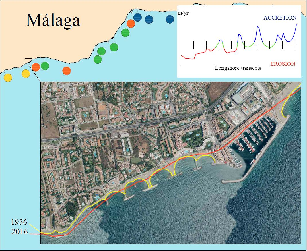
4. Results
5. Discussion
5.1. Evolution Classes at Natural Coastal Sectors
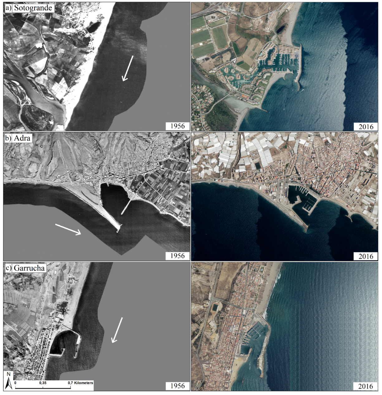
5.2. Evolution Classes versus Coastal Structures Location and Characteristics
5.3. Swash- and Drift-Aligned Coastal Sectors
6. Conclusions
Author Contributions
Funding
Acknowledgments
Conflicts of Interest
Appendix A

| ID | Coastal Name | Morphology | Number of the Defence Structures | Close to Harbour/Port (*) | ||
|---|---|---|---|---|---|---|
| Groins | Breakwaters | Revetments | ||||
| 1 | La Línea de la Concepción | Straight coast | 7 | − | − | Yes (N) |
| 2 | El Zabal | Straight coast | − | − | − | Yes (S) |
| 3 | Torreguadiaro | Straight coast and Pocket beach | 3 | − | − | Yes |
| 4 | La Chullera | Straight coast | 1 | − | 1 | Yes (N) |
| 5 | San Luis de Sabinillas | Straight coast | − | − | − | Yes (S) |
| 6 | La Gaspara | Straight coast and Pocket beach | 2 | − | 3 | Yes |
| 7 | Estepona | Straight coast | 2 | 1 | − | Yes (N) |
| 8 | Guadalmansa (S) | Straight coast | 1 | − | 1 | No |
| 9 | San Pedro de Alcántara | Straight coast | 11 | 5 | 1 | No (SW); Yes (NW) |
| 10 | Coral Beach (Puerto Banús $N4) | Pocket beach | 1 | − | − | Yes (SW) |
| 11 | Marbella (W) | Straight coast | 2 | 1 | − | Yes (NW) |
| 12 | Marbella (E) | Pocket beach and Straight coast | 12 | − | − | Yes (W) |
| 13 | Mijas | Straight coast | − | − | − | Yes (W) |
| 14 | Fuengirola (S) | Straight coast | 2 | 1 | 1 | Yes |
| 15 | Benalmádena | Straight coast | 6 | 2 | 2 | Yes (NE) |
| 16 | Torremolinos | Straight coast | − | − | 2 | Yes (SW) |
| 17 | Málaga (S) | Straight coast | 1 | − | − | Yes (NE) |
| 18 | Málaga (E) | Straight coast | 1 | 13 | 2 | Yes (W and E) |
| 19 | La Cala del Moral | Pocket beach | 1 | 1 | 1 | No |
| 20 | Rincón de La Victoria | Straight coast | − | − | 5 | No |
| 21 | Torre del Mar | Straight coast | 10 | 2 | 2 | Yes |
| 22 | Caleta de Vélez | Straight coast | 1 | − | 5 | No |
| 23 | Nerja | Pocket beach | − | − | 1 | No |
| 24 | La Herradura | Pocket beach | − | − | − | No |
| 25 | Almuñécar | Pocket beach | − | − | − | No |
| 26 | Velilla Tamaray | Pocket beach | 3 | 1 | 1 | No |
| 27 | Salobreña | Straight coast | 2 | − | − | Yes (E) |
| 28 | Torrenueva | Pocket beach | 4 | 4 | − | Yes (W) |
| 29 | Carchuna | Straight coast | − | − | − | No |
| 30 | Castel de Ferro | Pocket beach | − | 4 | − | No |
| 31 | La Mamola | Straight coast | 5 | − | 2 | No |
| 32 | Albuñol | Straight coast | 2 | − | 1 | No |
| 33 | Adra (E) | Straight coast | 8 | − | − | Yes (E) |
| 34 | Adra (W) | Straight coast | 88 | 2 | 9 | Yes (W) |
| 35 | Balerma | Straight coast | 8 | − | − | No |
| 36 | Ensenada de San Miguel | Pocket beach | 1 | − | − | Yes (E) |
| 37 | Almerimar | Pocket beach | 3 | 1 | − | Yes (NW) |
| 38 | San Agustín | Straight coast | − | − | − | No |
| 39 | Roquetas de Mar (S) | Straight coast | 2 | − | 1 | Yes (N) |
| 40 | Roquetas de Mar (N) | Straight coast | − | 1 | − | Yes (N and S) |
| 41 | Almería | Straight coast | 4 | 1 | − | Yes (W) |
| 42 | Costacabana | Straight coast | 6 | − | − | No |
| 43 | Cabo de Gata | Straight coast | − | − | − | No |
| 44 | Playa de los Genoveses | Pocket beach | − | − | − | No |
| 45 | Carboneras | Pocket beach | − | − | − | Yes |
| 46 | La Parata | Straight coast | − | − | − | No |
| 47 | Garrucha | Straight coast | 3 | 2 | − | Yes (S) |
| Year | Error Components (m) | ||||||
|---|---|---|---|---|---|---|---|
| Area 1 (1–12 units) | |||||||
| 1956 | 7.60 | 1.00 | 4.00 | 0.50 | 2.60 | 11.70 | 14.80 |
| 1977 | 2.10 | 0.50 | 3.30 | 0.50 | 2.60 | 11.70 | 12.60 |
| 2001 | 2.10 | 0.50 | 1.00 | 1.00 | 2.60 | 11.70 | 12.30 |
| 2010 | 1.90 | 0.50 | 0.50 | 0.00 | 2.60 | 11.70 | 12.10 |
| 2016 | 0.70 | 0.25 | 0.50 | 0.00 | 2.60 | 11.70 | 12.00 |
| Area 2 (13–23 units) | |||||||
| 1956 | 7.60 | 1.00 | 4.00 | 0.50 | 2.80 | 7.20 | 11.60 |
| 1977 | 2.10 | 0.50 | 3.30 | 0.50 | 2.80 | 7.20 | 8.70 |
| 2001 | 2.10 | 0.50 | 1.00 | 1.00 | 2.80 | 7.20 | 8.20 |
| 2010 | 1.90 | 0.50 | 0.50 | 0.00 | 2.80 | 7.20 | 8.00 |
| 2016 | 0.70 | 0.25 | 0.50 | 0.00 | 2.80 | 7.20 | 7.80 |
| Area 3 (24–37 units) | |||||||
| 1956 | 7.60 | 1.00 | 4.00 | 0.50 | 3.20 | 4.30 | 10.20 |
| 1977 | 2.10 | 0.50 | 3.30 | 0.50 | 3.20 | 4.30 | 6.70 |
| 2001 | 2.10 | 0.50 | 1.00 | 1.00 | 3.20 | 4.30 | 5.90 |
| 2010 | 1.90 | 0.50 | 0.50 | 0.00 | 3.20 | 4.30 | 5.70 |
| 2016 | 0.70 | 0.25 | 0.50 | 0.00 | 3.20 | 4.30 | 5.40 |
| Area 4 (38–43 units) | |||||||
| 1956 | 7.6 | 1.00 | 4.00 | 0.50 | 3.10 | 2.80 | 9.60 |
| 1977 | 2.10 | 0.50 | 3.30 | 0.50 | 3.10 | 2.80 | 5.80 |
| 2001 | 2.10 | 0.50 | 1.00 | 1.00 | 3.10 | 2.80 | 4.90 |
| 2010 | 1.90 | 0.50 | 0.50 | 0.00 | 3.10 | 2.80 | 4.60 |
| 2016 | 0.70 | 0.25 | 0.50 | 0.00 | 3.10 | 2.80 | 4.30 |
| Area 5 (44–47 units) | |||||||
| 1956 | 7.60 | 1.00 | 4.00 | 0.50 | 3.30 | 1.40 | 9.40 |
| 1977 | 2.10 | 0.50 | 3.30 | 0.50 | 3.30 | 1.40 | 5.40 |
| 2001 | 2.10 | 0.50 | 1.00 | 1.00 | 3.30 | 1.40 | 4.40 |
| 2010 | 1.90 | 0.50 | 0.50 | 0.00 | 3.30 | 1.40 | 4.10 |
| 2016 | 0.70 | 0.25 | 0.50 | 0.00 | 3.30 | 1.40 | 3.70 |
| Unit | Name | Accretion (%) | Stability (%) | Erosion (%) | Unit Net Balance * | Longitude (km) | Morphology | ||||
|---|---|---|---|---|---|---|---|---|---|---|---|
| Very High | High | Moderate | Moderate | High | Very High | ||||||
| 1 | La Línea de la Concepción | 0.0 | 1.1 | 3.2 | 60.6 | 35.1 | 0.0 | 0.0 | E | 2.3 | |
| 2 | El Zabal | 0.0 | 53.2 | 36.2 | 10.6 | 0.0 | 0.0 | 0.0 | A | 7.5 | |
| 3 | Torreguadiaro | 0.0 | 1.2 | 9.0 | 25.3 | 20.4 | 21.6 | 22.4 | E | 6.0 | |
| 4 | La Chullera | 0.0 | 0.5 | 1.0 | 16.7 | 41.4 | 39.9 | 0.5 | E | 5.0 | |
| 5 | San Luis de Sabinillas | 0.8 | 1.7 | 5.9 | 22.9 | 25.4 | 43.2 | 0.0 | E | 2.9 | |
| 6 | La Gaspara | 0.0 | 0.0 | 0.0 | 0.9 | 15.1 | 83.9 | 0.0 | E | 5.4 | Drift aligned |
| 7 | Estepona | 5.5 | 28.6 | 14.3 | 50.5 | 1.1 | 0.0 | 0.0 | A | 2.2 | NE-SW |
| 8 | Guadalmansa (S) | 0.0 | 0.0 | 0.0 | 45.9 | 50.0 | 4.1 | 0.0 | E | 7.3 | |
| 9 | San Pedro de Alcántara | 0.0 | 4.4 | 4.9 | 14.6 | 45.5 | 30.7 | 0.0 | E | 10.2 | |
| 10 | Coral Beach (Puerto Banús N) | 0.9 | 5.2 | 2.6 | 20.7 | 34.5 | 36.2 | 0.0 | E | 2.9 | |
| 11 | Marbella (W) | 0.0 | 6.5 | 22.0 | 61.8 | 8.1 | 1.6 | 0.0 | A | 3.0 | |
| 12 | Marbella (E) | 0.6 | 5.8 | 2.7 | 26.6 | 31.4 | 32.9 | 0.0 | E | 12.8 | |
| 13 | Mijas | 0.0 | 7.0 | 5.7 | 49.4 | 20 | 14.5 | 3.5 | E | 10.0 | |
| 14 | Fuengirola (S) | 0.0 | 1.9 | 20.1 | 50 | 26.9 | 1.1 | 0.0 | E | 6.5 | |
| 15 | Benalmádena | 3.4 | 17.9 | 22.8 | 48.1 | 6.6 | 1.1 | 0.0 | A | 8.7 | |
| 16 | Torremolinos | 0.0 | 21.2 | 24.0 | 24.5 | 13.1 | 11.4 | 5.8 | A | 8.9 | |
| 17 | Málaga (S) | 2.1 | 2.1 | 2.6 | 23.7 | 9.8 | 53.1 | 6.7 | E | 4.8 | Swash aligned |
| 18 | Málaga (E) | 22.4 | 43.7 | 12.5 | 13.3 | 4.9 | 3.0 | 0.0 | A | 6.5 | |
| 19 | La Cala del Moral | 1.2 | 42.7 | 28.0 | 28.0 | 0.0 | 0.0 | 0.0 | A | 2.0 | |
| 20 | Rincón de La Victoria | 1.5 | 33.6 | 14.7 | 25.0 | 13.2 | 8.0 | 3.8 | A | 16.2 | |
| 21 | Torre del Mar | 0.0 | 31.0 | 24.0 | 17.1 | 11.2 | 8.9 | 7.8 | A | 6.4 | |
| 22 | Caleta de Vélez | 0.0 | 7.1 | 9.5 | 33.5 | 24.9 | 24.9 | 0.0 | E | 8.0 | |
| 23 | Nerja | 0.0 | 0.0 | 4.3 | 47.8 | 47 | 0.9 | 0.0 | E | 2.8 | |
| 24 | La Herradura | 0.0 | 0.0 | 29.8 | 70.2 | 0.0 | 0.0 | 0.0 | A | 2.1 | |
| 25 | Almuñécar | 0.0 | 2.3 | 14 | 83.7 | 0.0 | 0.0 | 0.0 | A | 1.0 | |
| 26 | Velilla Tamaray | 15.7 | 39.3 | 30.7 | 14.3 | 0.0 | 0.0 | 0.0 | A | 3.5 | |
| 27 | Salobreña | 22 | 14.4 | 8.0 | 9.8 | 11.0 | 23.1 | 11.7 | A | 6.6 | |
| 28 | Torrenueva | 3.4 | 22.8 | 15.9 | 23.4 | 6.2 | 28.3 | 0.0 | A | 3.6 | |
| 29 | Carchuna | 0.0 | 3.5 | 2.5 | 77.1 | 15.9 | 1.0 | 0.0 | E | 5.0 | Drift aligned |
| 30 | Castel de Ferro | 0.0 | 14.9 | 5.7 | 56.3 | 10.3 | 12.6 | 0.0 | E | 2.1 | W-E |
| 31 | La Mamola | 0.0 | 15.9 | 29.0 | 28.3 | 19.3 | 7.6 | 0.0 | A | 3.6 | |
| 32 | Albuñol | 16.2 | 12.7 | 6.4 | 24.5 | 36.8 | 3.4 | 0.0 | E | 5.1 | |
| 33 | Adra (E) | 0.0 | 0.6 | 12.5 | 78.8 | 8.1 | 0.0 | 0.0 | A | 4.0 | |
| 34 | Adra (W) | 0.0 | 1.5 | 6.9 | 24.1 | 28.0 | 19.0 | 20.5 | E | 8.3 | |
| 35 | Balerma | 0.0 | 0.0 | 0.9 | 75.8 | 22.7 | 0.6 | 0.0 | E | 8.4 | |
| 36 | Ensenada de San Miguel | 0.5 | 9.9 | 3.5 | 5.4 | 4.5 | 76.2 | 0.0 | E | 5.0 | |
| 37 | Almerimar | 0.0 | 10.6 | 1.1 | 1.1 | 2.1 | 21.3 | 63.8 | E | 2.3 | |
| 38 | San Agustín | 0.0 | 25.1 | 13.7 | 11.3 | 10.7 | 23.4 | 15.8 | E | 12.6 | |
| 39 | Roquetas de Mar (S) | 0.0 | 0.0 | 2.4 | 34.1 | 20.2 | 30.8 | 12.5 | E | 5.2 | |
| 40 | Roquetas de Mar (N) | 0.3 | 2.0 | 1.0 | 22.4 | 33.4 | 40.8 | 0.0 | E | 7.4 | Swash aligned |
| 41 | Almería | 1.0 | 14.1 | 11.5 | 23 | 15.3 | 35.1 | 0.0 | E | 7.8 | |
| 42 | Costacabana | 0.0 | 1.4 | 2.5 | 82.0 | 11.2 | 3.0 | 0.0 | E | 9.1 | |
| 43 | Cabo de Gata | 0.0 | 0.0 | 5.7 | 55.4 | 27.0 | 11.8 | 0.0 | E | 12.6 | |
| 44 | Playa de los Genoveses | 0.0 | 0.0 | 0.0 | 13.8 | 23.1 | 63.1 | 0.0 | E | 1.6 | |
| 45 | Carboneras | 9.0 | 11.2 | 2.2 | 6.0 | 34.3 | 37.3 | 0.0 | E | 3.3 | Drift aligned |
| 46 | La Parata | 1.5 | 7.5 | 6.0 | 3.6 | 52.4 | 28.9 | 0.0 | E | 8.6 | NE-SW |
| 47 | Garrucha | 2.7 | 5.7 | 29.7 | 24.3 | 3.8 | 13.3 | 20.5 | E | 7.0 | |
References
- Brown, A.; McLachlan, A. Sandy shore ecosystems and the threats facing them: Some predictions for the year 2025. Environ. Conserv. 2002, 29, 62–77. [Google Scholar] [CrossRef]
- Klein, Y.L.; Osleeb, J.P.; Viola, M.R. Tourism-generated earnings in the coastal zone: A regional analysis. J. Coast. Res. 2004, 20, 1080–1088. [Google Scholar]
- UNWTO. Tourism Highlights; Technical Report; United Nations World Tourism Organization: Madrid, Spain, 2015. [Google Scholar]
- Jones, A.; Phillips, M. Disappearing Destinations: Climate Change and Future Challenges for Coastal Tourism; CABI International: Wallingford, UK, 2011. [Google Scholar]
- Bacon, S.; Carter, D.T. Wave climate changes in the North Atlantic and North Sea. Int. J. Climatol. 1991, 11, 545–558. [Google Scholar] [CrossRef]
- Dupuis, H.; Michel, D.; Sottolichio, A. Wave climate evolution in the Bay of Biscay over two decades. J. Mar. Syst. 2006, 63, 105–114. [Google Scholar] [CrossRef]
- Komar, P.D.; Allan, J.C. Increasing hurricane-generated wave heights along the US East Coast and their climate controls. J. Coast. Res. 2008, 24, 479–488. [Google Scholar] [CrossRef]
- Soomere, T. Extremes and Decadal Variations of the Northern Baltic Sea Wave Conditions; Springer: Dordrecht, The Netherlands, 2008; pp. 139–157. [Google Scholar]
- Crowell, M.; Leatherman, S.P.; Buckley, M.K. Historical shoreline change: Error analysis and mapping accuracy. J. Coast. Res. 1991, 7, 839–852. [Google Scholar]
- Crowell, M.; Leatherman, S.P.; Buckley, M.K. Shoreline change rate analysis: Long term versus short term data. Shore Beach 1993, 61, 13–20. [Google Scholar]
- Jiménez, J.A.; Sánchez-Arcilla, A. Medium-term coastal response at the Ebro delta, Spain. Mar. Geol. 1993, 114, 105–118. [Google Scholar] [CrossRef]
- Gorman, L.; Morang, A.; Larson, R. Monitoring the coastal environment; part IV: Mapping, shoreline changes, and bathymetric analysis. J. Coast. Res. 1998, 14, 61–92. [Google Scholar]
- El-Asmar, H.M. Short term coastal changes along Damietta-Port Said coast northeast of the Nile Delta, Egypt. J. Coast. Res. 2002, 18, 33–441. [Google Scholar]
- Morton, R.A. Temporal and spatial variations in shoreline changes and their implications, examples from the Texas Gulf Coast. J. Sediment. Res. 1979, 49, 1101–1111. [Google Scholar]
- Corbau, C.; Tessier, B.; Chamley, H. Seasonal evolution of shoreface and beach system morphology in a macrotidal environment, Dunkerque area, Northern France. J. Coast. Res. 1999, 15, 97–110. [Google Scholar]
- Anfuso, G.; Gracia, F. Morphodynamic characteristics and short-term evolution of a coastal sector in SW Spain: Implications for coastal erosion management. J. Coast. Res. 2005, 21, 1139–1153. [Google Scholar] [CrossRef]
- Anfuso, G.; Pranzini, E.; Vitale, G. An integrated approach to coastal erosion problems in northern Tuscany (Italy): Littoral morphological evolution and cell distribution. Geomorphology 2011, 129, 204–214. [Google Scholar] [CrossRef]
- Romine, B.; Fletcher, C.; Genz, A.; Barbee, M.; Dyer, M.; Anderson, T.; Lim, S.; Vitousek, S.; Bochicchio, C.; Richmond, B. National Assessment of Shoreline Change: A GIS Compilation of Vector Shorelines and Associated Shoreline Change Data for the Sandy Shorelines of Kauai, Oahu and Maui, Hawaii. U.S. Geological Survey Open-File Report 2011-1009. Available online: https://pubs.usgs.gov/of/2011/1009/ (accessed on 10 June 2019).
- Rangel-Buitrago, N.G.; Anfuso, G.; Williams, A.T. Coastal erosion along the Caribbean coast of Colombia: Magnitudes, causes and management. Ocean Coast. Manag. 2015, 114, 129–144. [Google Scholar] [CrossRef]
- Leatherman, S.P. Shoreline mapping: A comparison of techniques. Shore Beach 1983, 51, 28–33. [Google Scholar]
- Houston, J. The economic value of beaches: A 2013 update. Shore Beach 2013, 81, 3–11. [Google Scholar]
- Clark, J.R. Coastal Zone Management Handbook; CRC Press/Lewis Publishers: Boca Raton, FL, USA, 1996. [Google Scholar]
- UNWTO. Tourism Highlights; Technical Report; United Nations World Tourism Organization: Madrid, Spain, 2006. [Google Scholar]
- Dodds, R.; Kelman, I. How climate change is considered in sustainable tourism policies: A case of the Mediterranean islands of Malta and Mallorca. Tour. Rev. Int. 2008, 12, 57–70. [Google Scholar] [CrossRef]
- Malvárez, G.C. The history of shoreline stabilization on the Spanish Costa del Sol. In Pitfalls of Shoreline Stabilization; Springer: Dordrecht, The Netherlands, 2012; pp. 235–249. [Google Scholar]
- Martínez, J.M.R.; Padilla, Y.R.; Jurado, E.N. Atributos urbanos contemporáneos del litoral mediterráneo en la crisis global: Caso de la zona metropolitana de la Costa del Sol. Scr. Nova Rev. Electrónica De Geogr. Y Cienc. Soc. 2015, 19. [Google Scholar] [CrossRef]
- Fletcher, C.H.; Romine, B.M.; Genz, A.S.; Barbee, M.M.; Dyer, M.; Anderson, T.R.; Lim, S.C.; Vitousek, S.; Bochicchio, C.; Richmond, B.M. National Assessment of Shoreline Change: Historical Shoreline Change in the Hawaiian Islands; USGS Publications Warehouse: Reston, VA, USA, 2012. [Google Scholar]
- Salman, A.; Lombardo, S.; Doody, P. Living with Coastal Erosion in Europe: Sediment and Space for Sustainability; Technical Report; EUCC: Warnemünde, Germany, 2004. [Google Scholar]
- Ponte Lira, C.; Nobre Silva, A.; Taborda, R.; Freire de Andrade, C. Coastline evolution of Portuguese low-lying sandy coast in the last 50 years: An integrated approach. Earth Syst. Sci. Data 2016, 8, 265–278. [Google Scholar] [CrossRef]
- Guisado, E.; Malvárez, G.C.; Navas, F. Morphodynamic environments of the Costa del Sol, Spain. J. Coast. Res. 2013, 65, 500–506. [Google Scholar] [CrossRef]
- Manno, G.; Anfuso, G.; Messina, E.; Williams, A.T.; Suffo, M.; Liguori, V. Decadal evolution of coastline armouring along the Mediterranean Andalusia littoral (South of Spain). Ocean Coast. Manag. 2016, 124, 84–99. [Google Scholar] [CrossRef]
- Zviely, D.; Klein, M. The environmental impact of the Gaza Strip coastal constructions. J. Coast. Res. 2003, 19, 1122–1127. [Google Scholar]
- Anfuso, G.; Dominguez, L.; Gracia, F. Short and medium-term evolution of a coastal sector in Cadiz, SW Spain. Catena 2007, 70, 229–242. [Google Scholar] [CrossRef]
- Anfuso, G.; Martínez-del Pozo, J.; Rangel-Buitrago, N. Bad practice in erosion management: The southern Sicily case study. In Pitfalls of Shoreline Stabilization: Selected Case Studies; Cooper, J.A.G., Pilkey, O.H., Eds.; Springer: Dordrecht, The Netherlands, 2012; pp. 215–233. [Google Scholar]
- Antony, E.; Sabatier, F. Coastal Stabilization Practice in France; Earthscan Routledge: London, UK, 2013; p. 253. [Google Scholar]
- Anthony, E.J. The Human influence on the Mediterranean coast over the last 200 years: A brief appraisal from a geomorphological perspective. Géomorphol. Relief Process. Environ. 2014, 20, 219–226. [Google Scholar] [CrossRef]
- Berlanga-Robles, C.A.; Ruiz-Luna, A. Land use mapping and change detection in the coastal zone of northwest Mexico using remote sensing techniques. J. Coast. Res. 2002, 18, 514–522. [Google Scholar]
- Sabatier, F.; Samat, O.; Brunel, C.; Heurtefeux, H.; Delanghe-Sabatier, D. Determination of set-back lines on eroding coasts. Example of the beaches of the Gulf of Lions (French Mediterranean Coast). J. Coast. Conserv. 2009, 13, 57. [Google Scholar] [CrossRef]
- Prieto, A.; Ojeda, J.; Rodríguez, S.; Gracia, J.; Del Río, L. Procesos erosivos (tasas de erosión) en los deltas mediterráneos andaluces: Herramientas de análisis espacial (DSAS) y evolución temporal (servicios OGC). In Tecnologías de la Información Geográfica en el Contexto del Cambio Global, Proceedings of the XV Congreso NAcional de Tecnologías de la Información Geográfica, Madrid, Spain, 19–21 September 2012; Martínez Vega, J., Martín Isabel, P., Eds.; CSIC—Instituto de Economía, Geografía y Demografía: Madrid, Spain, 2012; pp. 185–193. [Google Scholar]
- Félix, A.; Baquerizo, A.; Santiago, J.; Losada, M. Coastal zone management with stochastic multi-criteria analysis. J. Environ. Manag. 2012, 112, 252–266. [Google Scholar] [CrossRef]
- Guisado, E.; Málvarez, G. Multiple scale morphodynamic mapping: Methodological considerations and applications for the coastal atlas of Andalusia. J. Coast. Res. 2009, 56, 1513–1517. [Google Scholar]
- Molina, R.; Manno, G.; Lo Re, C.; Anfuso, G.; Ciraolo, G. Storm Energy Flux Characterization along the Mediterranean Coast of Andalusia (Spain). Water 2019, 11, 509. [Google Scholar] [CrossRef]
- López, M.F.P. El clima de Andalucía. In Geografía de Andalucía; Ariel Geografia: Barcellona, Spain, 2003; pp. 137–173. [Google Scholar]
- REDIAM Red, d.I.A.d.A. WMS, Tasas de erosión en el litoral andaluz. Available online: http://www.juntadeandalucia.es (accessed on 10 June 2019).
- Thieler, E.R.; Himmelstoss, E.A.; Zichichi, J.L.; Ergul, A. The Digital Shoreline Analysis System (DSAS) Version 4.0—An ArcGIS Extension for Calculating Shoreline Change; Technical Report; US Geological Survey: Reston, VA, USA, 2009.
- Anfuso, G.; Bowman, D.; Danese, C.; Pranzini, E. Transect based analysis versus area based analysis to quantify shoreline displacement: Spatial resolution issues. Environ. Monit. Assess. 2016, 188, 568. [Google Scholar] [CrossRef] [PubMed]
- Thieler, E.; Himmelstoss, E.; Zichichi, J.; Ergul, A. DSAS 4.0 Installation Instructions and User Guide, 4th ed.; U.S. Geological Survey Open-File Report 2008-1278, U.S. Geological Survey: Reston, VA, USA, 2009. [Google Scholar]
- Dolan, R.; Fenster, M.S.; Holme, S.J. Temporal analysis of shoreline recession and accretion. J. Coast. Res. 1991, 7, 723–744. [Google Scholar]
- Manno, G.; Re, C.L.; Ciraolo, G. Uncertainties in shoreline position analysis: The role of run-up and tide in a gentle slope beach. Ocean Sci. 2017, 13, 661. [Google Scholar] [CrossRef]
- Moore, L.J. Shoreline mapping techniques. J. Coast. Res. 2000, 16, 111–124. [Google Scholar]
- Dolan, R.; Hayden, B.P.; May, P.; May, S. The reliability of shoreline change measurements from aerial photographs. Shore Beach 1980, 48, 22–29. [Google Scholar]
- Douglas, B.C.; Crowell, M. Long-term shoreline position prediction and error propagation. J. Coast. Res. 2000, 16, 145–152. [Google Scholar]
- Pajak, M.J.; Leatherman, S. The high water line as shoreline indicator. J. Coast. Res. 2002, 18, 329–337. [Google Scholar]
- Boak, E.H.; Turner, I.L. Shoreline definition and detection: A review. J. Coast. Res. 2005, 21, 688–703. [Google Scholar] [CrossRef]
- Fisher, J.S.; Overton, M.F. Interpretation of shoreline position from aerial photographs. Coast. Eng. Proc. 1994, 1. [Google Scholar] [CrossRef]
- Del Río, L.; Gracia, F.J. Error determination in the photogrammetric assessment of shoreline changes. Nat. Hazards 2013, 65, 2385–2397. [Google Scholar] [CrossRef]
- Jabaloy, A.; Lobo, F.J.; Bárcenas, P.; Azor, A.; Fernández-Salas, L.M.; Díaz del Río, V. Evolución reciente del delta del Río Adra (SE España). Geo-Temas 2008, 10, 743–746. [Google Scholar]
- Martínez, A.B. Tratamiento técnico del borde litoral almeriense. In Actas de las Jornadas sobre el Litoral de Almería: Caracterización, Ordenación y Gestión de un Espacio Geográfico Celebradas en Almería, 20 a 24 de Mayo de 1997; Instituto de Estudios Almerienses: Almería, Spain, 1999; pp. 207–232. [Google Scholar]
- Viciana, A.M.L. La costa de Almería: Desarrollo socio-económico y degradación físico-ambiental (1957–2007). Paralelo 37° 2007, 19, 149–183. [Google Scholar]
- Syvitski, J.P.; Vörösmarty, C.J.; Kettner, A.J.; Green, P. Impact of humans on the flux of terrestrial sediment to the global coastal ocean. Science 2005, 308, 376–380. [Google Scholar] [CrossRef]
- Kim, J.; Choi, J.; Choi, C.; Hwang, C. Forecasting the potential effects of climatic and land-use changes on shoreline variation in relation to watershed sediment supply and transport. J. Coast. Res. 2016, 33, 874–888. [Google Scholar] [CrossRef]
- Frihy, O.E. Nile Delta shoreline changes: Aerial photographic study of a 28-year period. J. Coast. Res. 1988, 4, 597–606. [Google Scholar]
- Frihy, O.E.; Komar, P.D. Patterns of beach-sand sorting and shoreline erosion on the Nile Delta. J. Sediment. Res. 1991, 61, 544–550. [Google Scholar]
- Pranzini, E. Airborne LIDAR survey applied to the analysis of the historical evolution of the Arno River delta (Italy). J. Coast. Res. 2007, 50, 400–409. [Google Scholar]
- González, J.M.S.; Malvárez, G. La desembocadura del río Vélez (provincia de Málaga, España). Evolución reciente de un delta de comportamiento mediterráneo. Rev. C G 2003, 17, 47–61. [Google Scholar]
- Malvarez, G.; Pollard, J.; Rodriguez, R.D. Origins, management, and measurement of stress on the coast of southern Spain. Coast. Manag. 2000, 28, 215–234. [Google Scholar]
- Guisado-Pintado, E.; Malvárez, G. El rol de las tormentas en la evolución morfodinámica del Delta del río Vélez: Costa del Sol, Málaga. In Geo-Temas; Sociedad Geológica de España: Marbella, Spain, 2015; Volume 15, pp. 189–192. [Google Scholar]
- Del Río, J.; Malvárez, G.; Navas, F. Aportes sedimentarios fluviales en el sistema litoral y su importancia para la gestión de costas: El caso de la Ensenada de Marbella. In Análisis Espacial Y Representación Geográfica: Innovación Y Aplicación; Universidad Pablo de Olavide: Sevilla, Spain, 2015; pp. 2175–2177. [Google Scholar]
- Del Río, J.L.; Malvárez, G. Impacto de la regulación del río Verde en la erosión del sistema sedimentario litoral de la ensenada de Marbella, Costa del Sol. In XV Coloquio Ibérico de Geografía; Universidad de Murcia: Murcia, Spain, 2016; pp. 1–10. [Google Scholar]
- Del Rio, J.; García, G.M. Erosión costera y acumulación de sedimentos en los embalses: El caso de La Concepción en la Ensenada de Marbella, Málaga. Geotemas 2017, 17, 251–254. [Google Scholar]
- Valdemoro, H.I.; Jiménez, J.A. The influence of shoreline dynamics on the use and exploitation of Mediterranean tourist beaches. Coast. Manag. 2006, 34, 405–423. [Google Scholar] [CrossRef]
- Dehouck, A.; Dupuis, H.; Sénéchal, N. Pocket beach hydrodynamics: The example of four macrotidal beaches, Brittany, France. Mar. Geol. 2009, 266, 1–17. [Google Scholar] [CrossRef]
- Bray, M.J.; Carter, D.J.; Hooke, J.M. Littoral cell definition and budgets for central southern England. J. Coast. Res. 1995, 11, 381–400. [Google Scholar]
- Pranzini, E.; Anfuso, G.; Cinelli, I.; Piccardi, M.; Vitale, G. Shore Protection Structures Increase and Evolution on the Northern Tuscany Coast (Italy): Influence of Tourism Industry. Water 2018, 10, 1647. [Google Scholar] [CrossRef]
- Sanuy, M.; Jiménez, J.A. Sensitivity of Storm-Induced Hazards in a Highly Curvilinear Coastline to Changing Storm Directions. The Tordera Delta Case (NW Mediterranean). Water 2019, 11, 747. [Google Scholar] [CrossRef]
- Griggs, G.B. The impacts of coastal armoring. Shore Beach 2005, 73, 13–22. [Google Scholar]
- Dugan, J.; Airoldi, L.; Chapman, M.; Walker, S.; Schlacher, T.; Wolanski, E.; McLusky, D. 8.02-Estuarine and coastal structures: Environmental effects, a focus on shore and nearshore structures. In Treatise on Estuarine and Coastal Science; Wolanski, E., McLusky, D.S., Eds.; Academic Press: Waltham, MA, USA, 2011; Volume 8, pp. 17–41. [Google Scholar]
- Nordstrom, K.F. Beaches and Dunes of Developed Coasts; Cambridge University Press: Cambridge, UK, 2000. [Google Scholar]
- Miles, J.R.; Russell, P.E.; Huntley, D.A. Field measurements of sediment dynamics in front of a seawall. J. Coast. Res. 2001, 17, 195–206. [Google Scholar]
- Anfuso, G.; Martínez-del Pozo, J.Á.; Rangel-Buitrago, N. Morphological cells in the Ragusa littoral (Sicily, Italy). J. Coast. Conserv. 2013, 17, 369–377. [Google Scholar] [CrossRef] [Green Version]
- Cooper, J.; Anfuso, G.; Del Río, L. Bad beach management: European perspectives. Geol. Soc. Am. Ser. 2009, 460, 167–179. [Google Scholar]
- Wiggins, M.; Scott, T.; Masselink, G.; Russell, P.; Valiente, N.G. Regionally-Coherent Embayment Rotation: Behavioural Response to Bi-Directional Waves and Atmospheric Forcing. J. Mar. Sci. Eng. 2019, 7, 116. [Google Scholar] [CrossRef]
- Burningham, H.; French, J. Understanding coastal change using shoreline trend analysis supported by cluster-based segmentation. Geomorphology 2017, 282, 131–149. [Google Scholar] [CrossRef]


| Year | Flight | Colour Film | Scale | Spatial Resolution (m) |
|---|---|---|---|---|
| 1956 | 1956–57 | Black and white | 1:10,000 | 1.0 |
| 1977 | Iryda flight 1977–83 | Black and white | 1:5000 | 0.5 |
| 2001 | 2001–02 | Colour | 1:10,000 | 0.5 |
| 2010 | PNOA 2010–11 | Colour | 1:10,000 | 0.5 |
| 2016 | PNOA 2016 | Colour | 1:5000 | 0.25 |
| Class | Beach State | m/year |
|---|---|---|
| 1 | Very high accretion | ≥+1.5 |
| 2 | High accretion | ≥+0.5; <+1.5 |
| 3 | Moderate accretion | ≥+0.2; <+0.5 |
| 4 | Stability | >−0.2; <+0.2 |
| 5 | Moderate erosion | >−0.5; ≤−0.2 |
| 6 | High erosion | >−1.5; ≤−0.5 |
| 7 | Very high erosion | ≤−1.5 |
© 2019 by the authors. Licensee MDPI, Basel, Switzerland. This article is an open access article distributed under the terms and conditions of the Creative Commons Attribution (CC BY) license (http://creativecommons.org/licenses/by/4.0/).
Share and Cite
Molina, R.; Anfuso, G.; Manno, G.; Gracia Prieto, F.J. The Mediterranean Coast of Andalusia (Spain): Medium-Term Evolution and Impacts of Coastal Structures. Sustainability 2019, 11, 3539. https://doi.org/10.3390/su11133539
Molina R, Anfuso G, Manno G, Gracia Prieto FJ. The Mediterranean Coast of Andalusia (Spain): Medium-Term Evolution and Impacts of Coastal Structures. Sustainability. 2019; 11(13):3539. https://doi.org/10.3390/su11133539
Chicago/Turabian StyleMolina, Rosa, Giorgio Anfuso, Giorgio Manno, and F. Javier Gracia Prieto. 2019. "The Mediterranean Coast of Andalusia (Spain): Medium-Term Evolution and Impacts of Coastal Structures" Sustainability 11, no. 13: 3539. https://doi.org/10.3390/su11133539