Comparing the Residential Sustainability of Two Transformation Models for Chinese Urban Villages: Demolition/Relocation Market-Oriented and New Rural Construction


Abstract
1. Introduction
2. Literature Review and Theoretical Construction
2.1. Analysis Based on the Theory of Sustainable Livelihoods
2.1.1. Rural Areas: A Field of Livelihood Construction
2.1.2. Villagers: Actors to Adopt Multiple Livelihood Strategies
2.1.3. Homestead: The Most Important Livelihood Asset of villagers
2.2. Demolition/Relocation Market-Oriented Model of Urban Villages
2.3. Construction of a New Socialist Countryside
3. Materials and Methods
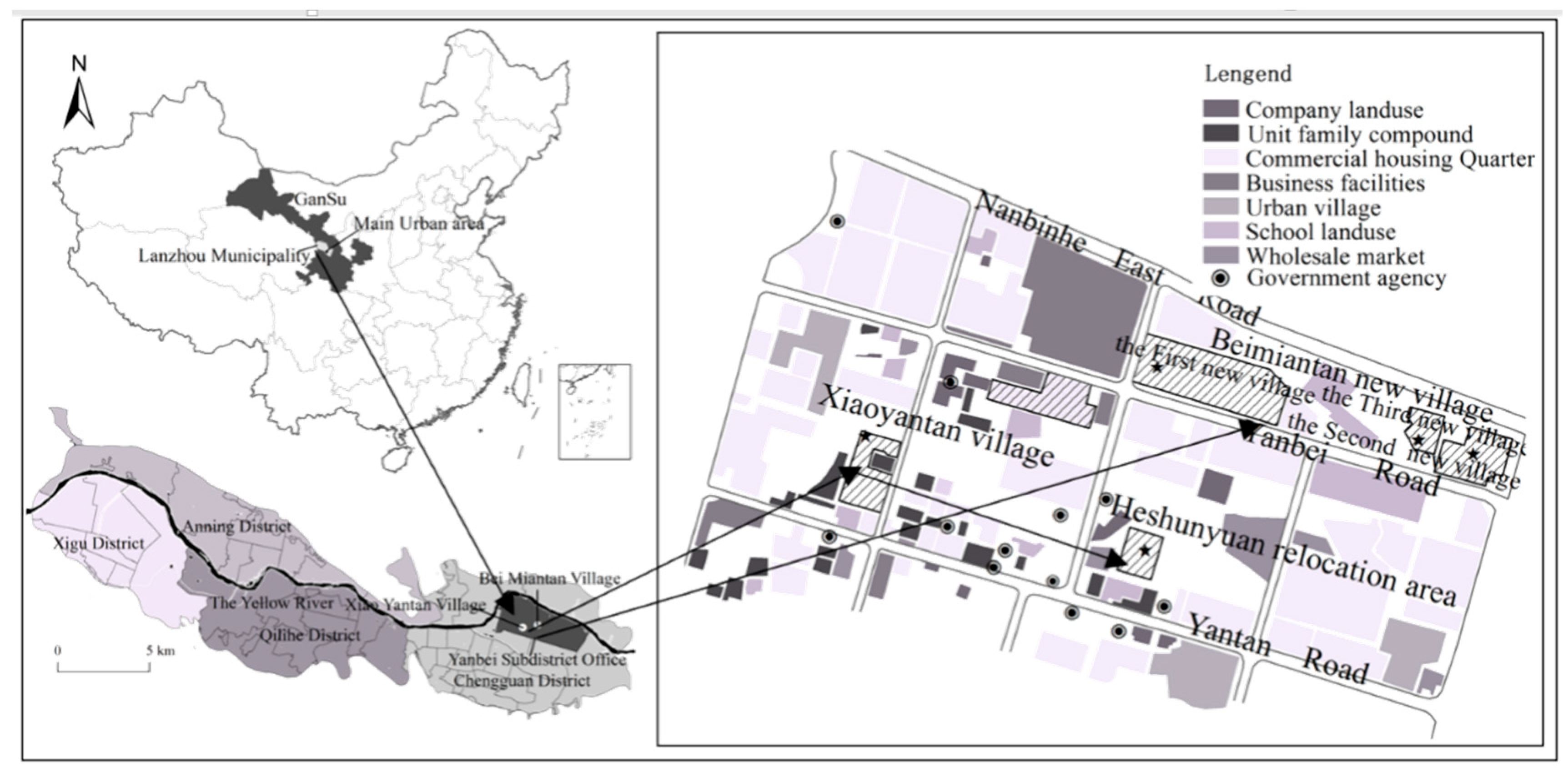
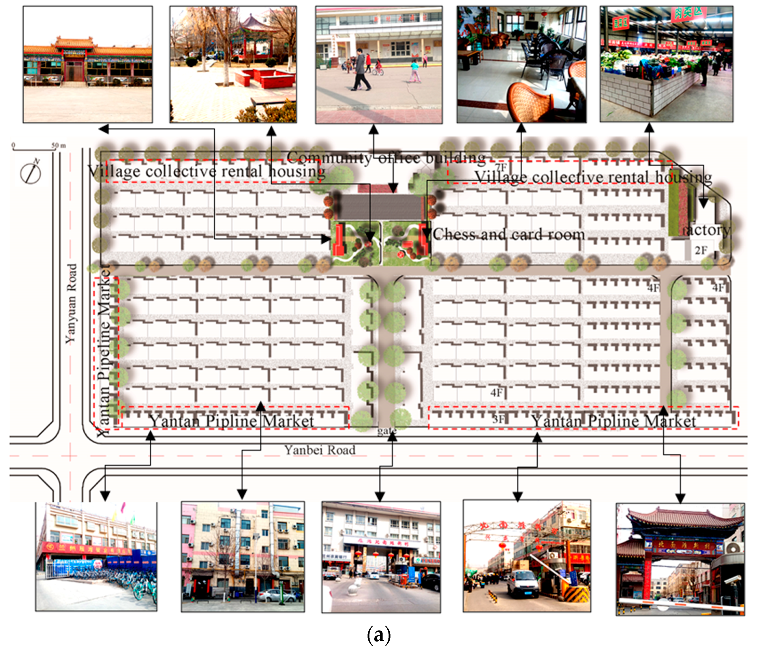
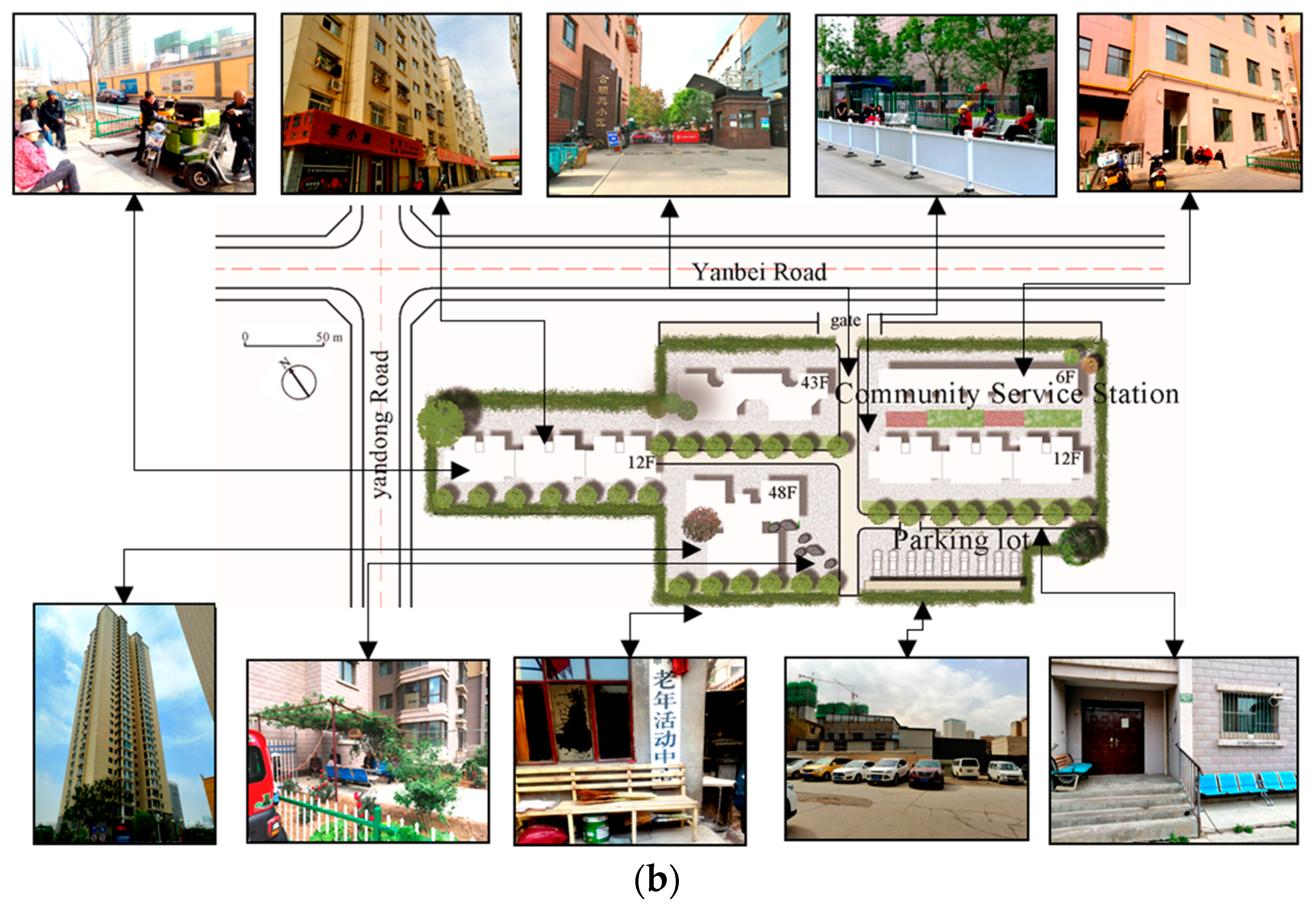
3.1. Case Study Area
3.2. Survey Design and Data Collection
4. Results
4.1. Sustainable Measurement of Housing Condition
4.2. Sustainable Measurement of Community Environment and Livelihood
4.3. Analysis of Influencing Mechanisms
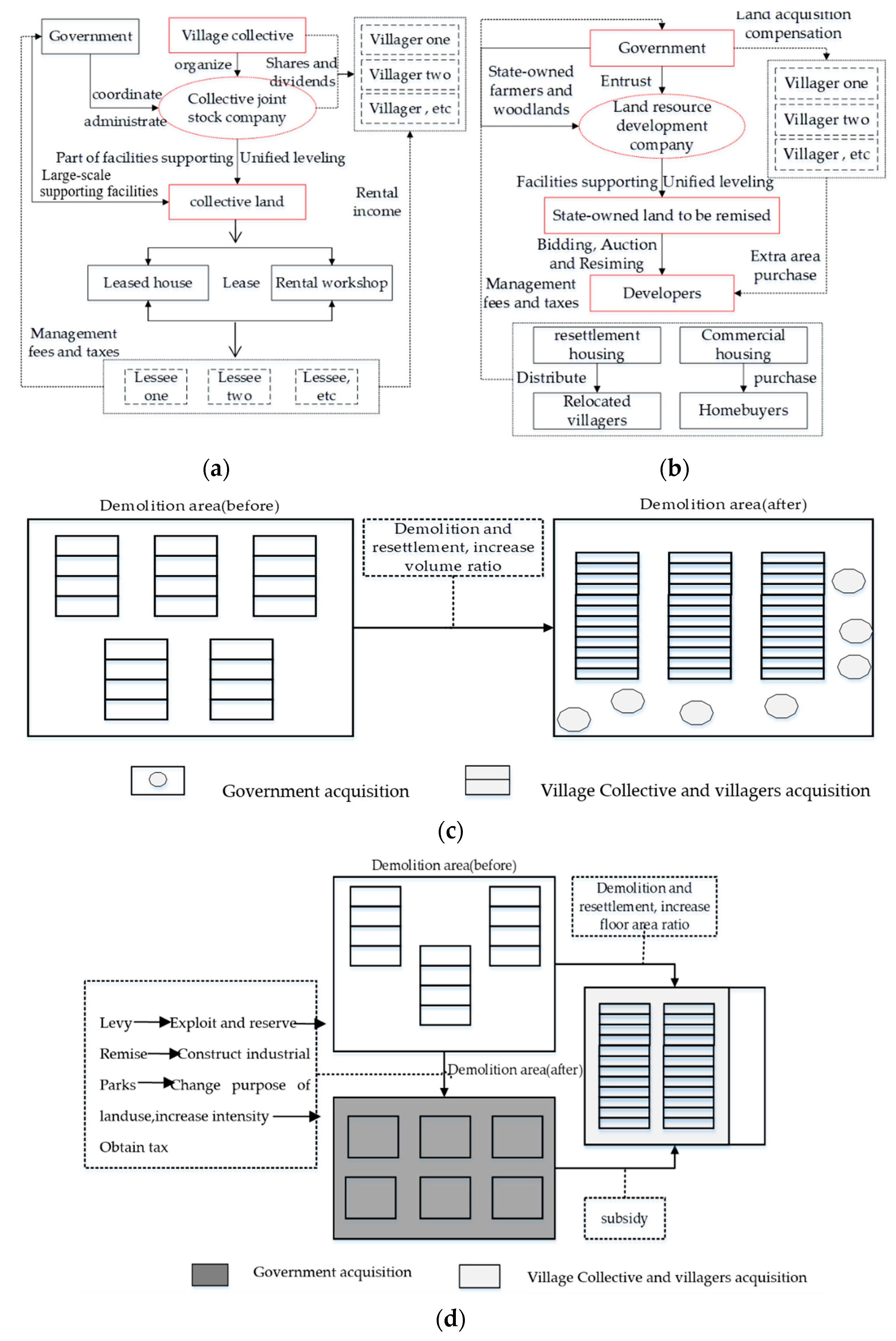
4.3.1. Land Development Right Allocation Model and Earning Redistribution
4.3.2. Collective Economy and Community Transformation
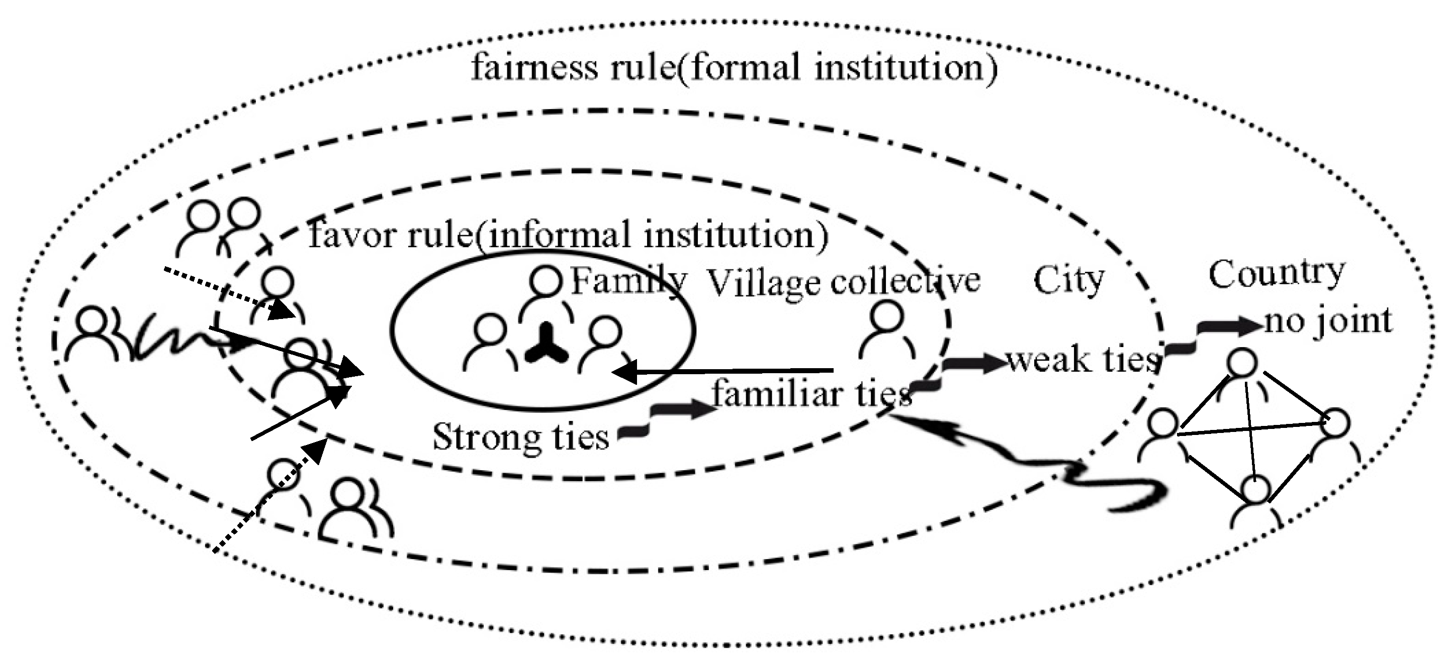
4.3.3. Informal Institutions and Village Social Relationship Networks
5. Conclusions and Discussion
5.1. Conclusion
5.2. Discussion
5.3. Limitations
Author Contributions
Funding
Acknowledgments
Conflicts of Interest
Appendix A

| Shorthand | Sub Index | Weighting Method |
|---|---|---|
| HOI | Housing forms and property Rights | Rented house = 1; accommodation = 2; self-built house = 3; self-purchased house = 4 |
| HCI | Per average housing area(m2) | >=46 m2 = 1;36~45 m2 = 2;21~35 m2 = 3; <=20 m2 = 4 |
| Housing set ratio | Complete set house = 1; incomplete set house = 2; bungalow = 3 | |
| HPI | Housing function | Only living room = 2; both life, production and business use = 1 |
| Housing privacy | The five-point Likert scale: [1 2 3 4 5] | |
| HFI | Basic facility Index | I1 = ∑Ia/42, Ia is total score of the former seven items facilities ownership |
| Intermediate facilities index | I2 = ∑Ib/42, Ib is total score of 8~14 items facility ownership | |
| Advanced facilities index | I3= ∑Ic/42, Ic is the total score of 15-21 items facility ownership | |
| Overall facility index | I = ∑I/42, I is total score all facilities ownership | |
| HQI | Building quality | The five-point Likert scale: [1 2 3 4 5] |
| Ventilation and lighting | The five-point Likert scale: [1 2 3 4 5] | |
| Residential area | The five-point Likert scale: [1 2 3 4 5] |
| Index Name | Range of Values | Average Value | |
|---|---|---|---|
| NRCM(BNV) | D/RMM(XV) | ||
| Property management | 1–5 | 4.07 | 3.20 |
| Support of public facilities | 1–5 | 4.08 | 2.97 |
| Landscape greening | 1–5 | 4.30 | 3.02 |
| Community security | 1–5 | 4.15 | 3.63 |
| Community public places and organizations | 1–5 | 3.3 | 1.98 |
| Convenience of public transport around | 1–5 | 4.47 | 4.22 |
| Distance between the relocation area and city center | 1–5 | 4.32 | 4.15 |
| Commuting status | 1–5 | 4.54 | 4.22 |
| Stability of income sources | 1–5 | 3.08 | 2.71 |
| Work intensity and tiredness after transformation | 1–8 | 3.72 | 6.09 |
| Income increase or decrease situation | 1–2 | 1.93 | 1.25 |
| Friendliness and support of community members | 1–5 | 4.32 | 3.62 |
| Scope of making friends in the community | 1–5 | 4.53 | 4.16 |
| Acquaintance social reservation situation | 1–2 | 2.00 | 1.8 |
| The impact of social networks on livelihood security | 1–5 | 3.50 | 3.05 |
| Coverage degree of self-owned social insurance | 1–5 | 1.92 | 2.07 |
| Guarantee level of self-owned social insurance | 1–5 | 2.96 | 3.20 |
| Satisfaction Degree of Settlement Compensation | 1–5 | 3.93 | 2.48 |
| Willingness of residence and old-age care in the resettlement area for a long time | 1–5 | 4.38 | 3.45 |
References
- Maryam, Z. Assessment of urban identity through a matrix of cultural landscapes. Cities 2018, 72, 21–31. [Google Scholar]
- Huang, X.L.; Sherk, J.T. Evaluation and Comparison of Sustainability Performance and Visual Preference of Residential Landscape Elements. HortTechnology 2014, 24, 318–324. [Google Scholar] [CrossRef]
- Wang, W.S. An analysis of the external space of residence. Planners 1999, 3, 67–70. [Google Scholar]
- Kovarik, J. Sustainability and Natural Landscape Stewardship: A US Conservation Case Study. In The Palgrave Handbook of Sustainability; Palgrave Macmillan: Bessinstock, UK, 2018; pp. 21–36. [Google Scholar]
- Paul, O.; Eveliene, S. How Could Companies Engage in Sustainable Landscape Management? An Exploratory Perspective. Sustainability 2018, 10, 2–15. [Google Scholar]
- Cheng, D.L. Research on the Scientific Development of Urban Village in China—In Perspective of Land -losing Farmers’ Sustainable Livelihoods. Urban Stud. 2008, 3, 68–79. [Google Scholar]
- Li, P.L. The End of Villages—The Story of Yangcheng Village; China Social Science Press: Beijing, China, 2004; pp. 2–12. [Google Scholar]
- Liu, J.Q.; Luo, R.; Shi, J.C. Study on the social security System of Landless Farmers from the Perspective of Sustainable Livelihood. Popul. Res. 2007, 4, 24–34. [Google Scholar]
- Lan, Y.Y. Urban Village—A Field Study on “New Village Cummnity”; SDX Joint Publishing Company: Shanghai, China, 2005; pp. 29–43. [Google Scholar]
- Mumford, L. The City in History, Its Origins, Its Transformation, and Its Prospects; Harcourt, Brace and World: San Diego, CA, USA, 1961; pp. 35–51. [Google Scholar]
- Jacobs, J. The Death and Life of Great American Cities; Penguin Books: London, UK, 1961; pp. 1–23. [Google Scholar]
- Alexander, C. The City is Not a Tree; Architectural Forum: London, UK, 1965; p. 122. [Google Scholar]
- John, F.C. Freedom to Build: Dweller Control of Housing Process; MacMillan Publishing Company: New York, NY, USA, 1972; pp. 123–130. [Google Scholar]
- Lan, Y.Y. On market-oriented urban village reform: A case study of Guangzhou urban village reform. China Urban Econ. 2010, 12, 275–278. [Google Scholar]
- Zhang, J.X.; Zhao, W. City village in dual-system environment: Development and significance. City Plan. 2007, 1, 63–67. [Google Scholar]
- Zhou, S.H.; Zhou, R.B.; Wu, Z.D. The Transformation of Village in City and the Transformation of Village Society under the Condition of RAPID Urbanization; Sun Yat-sen University Press: Guangzhou, China, 2011; pp. 33–40. [Google Scholar]
- Lan, Y.Y. The Social Foundation for the Reconstruction of Urban Village—Research with the Sample of Urban Village in Guangzhou. J. Cent. China Norm. Univ. 2007, 46, 55–60. [Google Scholar]
- Guo, Z.F. From Village Community to New Community: Research on Farmers’ Acculturation of Centralized Residence in Midwest China; Social Sciences Academic Press: Beijing, China, 2018; pp. 7–10. [Google Scholar]
- Chambers, R.; Conway, G. Sustainable Rural Livelihoods: Practical Concepts for the 21st Century; IDS Discussion Paper No. 296; Institute of Development Studies: Brighton, UK, 1992. [Google Scholar]
- Scoones, I. Sustainable Livelihoods and Rural Development; Practical Action Publishing: Rugby, UK, 2015. [Google Scholar]
- Bebbington, A. Capitals and capabilities: A framework for analysing peasant viability, rural livelihoods and poverty. World Dev. 1999, 27, 2012–2044. [Google Scholar] [CrossRef]
- Scoones, I. Livelihoods perspectives and rural development. J. Peasant. Stud. 2009, 36, 171–196. [Google Scholar] [CrossRef]
- Apine, E.; Turner, L.M.; Rodwell, L.D.; Bhatta, R. The application of the sustainable livelihood approach to small scale-fisheries: The case of mud crab Scylla serrata in South west India. Ocean Coast. Manag. 2019, 170, 17–28. [Google Scholar] [CrossRef]
- Garai, S.; Ghosh, M.K.; Maiti, S.; Garai, S.; Meena, B.S.; Dutta, T.K.; Kadian, K.S. Development and application of dairy-based sustainable livelihood security index in the districts of West Bengal, India: A tool for dairy development planning. J. Rural Stud. 2019, 17, 1–9. [Google Scholar] [CrossRef]
- Gilling, J.; Jones, S.; Duncan, A. Sector approaches, sustainable livelihoods and rural poverty reduction. Dev. Policy Rev. 2001, 19, 303–319. [Google Scholar] [CrossRef]
- Mazzone, A. Decentralised energy systems and sustainable livelihoods, what are the links? Evidence from two isolated villages of the Brazilian Amazon. Energy Build. 2019, 186, 138–146. [Google Scholar] [CrossRef]
- Alarcón, J.M.S.; Sato, C. Enacting peasant moral community economies for sustainable livelihoods: A case of women-led cooperatives in rural Mexico. World Dev. 2019, 115, 120–131. [Google Scholar] [CrossRef]
- Piketty, T. Capital in the Twenty-First Century; Harvard University Press: Cambridge, MA, USA, 2014; pp. 3–8. [Google Scholar]
- Chambers, R. Rural Development: Putting in the Last First; Prentice Hall: Harlow, NJ, USA, 1983. [Google Scholar]
- Arce, A. Value contestations in development interventions: Community development and sustainable livelihoods approaches. Community Dev. J. 2003, 38, 199–212. [Google Scholar] [CrossRef]
- Bebbington, A. Reencountering development: Livelihoods transitions and place transformations in the Andes. Ann. Assoc. Am. Geogr. 2001, 90, 495–520. [Google Scholar] [CrossRef]
- Giddens, A. The Constitution of Society; China Renmin University Press: Beijing, China, 2016; pp. 9–32. [Google Scholar]
- Addison, T.; Hulme, D.; Kanbur, R. Poverty Dynamics: Measurement and Understanding from an Interdisciplinary Perspective; Oxford University: Oxford, UK, 2009. [Google Scholar]
- David, W.O. Urban agriculture promotes sustainable livelihoods in Cape Town. Dev. S. Afr. 2019, 36, 17–32. [Google Scholar]
- Du, S.Y.; Xu, J.X. Study on the sustainable livelihood problems of land-loss farmers from the perspective of endogenous development. Economist 2016, 7, 76–83. [Google Scholar]
- Fang, P.; Chen, K.W.; Deng, Y.H. Thoughts on Opportunities and Countermeasures in Market-Oriented Transformation of “Village in the City” A Case Study of Xuzhou. Jiangsu Urban Plan. 2006, 8, 28–32. [Google Scholar]
- Cui, G.H.; Laurence, J.C. Urbanization from Below in China: Its Development and Mechanisms. Acta Geogr. Sin. 1999, 66, 106–115. [Google Scholar]
- Zhang, J.X.; Wu, F.L.; Ma, R. Institional Transition and Reconstruction of China’s Urban Space: Establishing a Institutional Analysis Structure for Spatital Evolution. City Plan. Rev. 2008, 246, 55–60. [Google Scholar]
- Zeng, W.; Wu, Q.Y.; Zhang, X.L. The New Features of Anti-coalition in China’s Urban Space: A Case Study of “No.94 yard” in Kunming. Sci. Geogr. Sin. 2015, 35, 551–557. [Google Scholar]
- Zhang, X. Reserach on Residents’ Satisfaction of Urban Village Reconstruction Under Market-oriented Model; Zhejiang University: Hangzhou, China, 2018. [Google Scholar]
- He, C.Z.; Li, Y.Q. A Summary of the Research on the Construction of New Socialist Countryside. Chin. Rural Econ. 2006, 1, 67–73. [Google Scholar]
- Bell, D. The Coming of Post-Industrial Society; The Commercial Press: Beijing, China, 1984; pp. 201–205. [Google Scholar]
- Castells, M. The Rise of the Network Society; John Wiley and Sons: Hoboken, NJ, USA, 2003. [Google Scholar]
- Ye, J.Z.; Na, K.P. Time of New Rural Construction. Chin. Rural Econ. 2007, 1, 12–19. [Google Scholar]
- Cai, F. An Economic Analysis of “Industry feeding Agriculture, Urban support for Countryside”. Chin. Rural Econ. 2006, 1, 11–17. [Google Scholar]
- Some Opinions of the State Council of the CPC Central Committee on Promoting the Construction of a New Socialist Countryside; (No. 1 Document of the CPC Central Committee); CPC Central Committee: Beijing, China, 2006.
- Huang, Z.Z. Small-Scale Farmers Undefined Economy and Social Changes in North China; Chung Hwa Book Co: Beijing, China, 2000; pp. 23–25. [Google Scholar]
- Popkin, S. The Rational Peasant: The Political Economy of Rural Society in the Vietnam; The Free Press: New York, NY, USA, 1979. [Google Scholar]
- Jiang, L.W.; Pang, L.H.; Zhang, Z.M. Living Conditions of Floating Population in Urban China. Popul. Res. 2004, 29, 16–27. [Google Scholar] [CrossRef]
- Wang, R.; Feng, K.W. Promotion of peasant housing since the reform and its reasons: A Empirical analysis on home survey data. J. China Agric. Univ. 2017, 22, 198–204. [Google Scholar]
- Gu, J.; Xu, J.C.; Lu, K. Progresses and challenges of the rural housing in China. China Popul. Resour. Environ. 2013, 23, 62–68. [Google Scholar]
- Lin, L.K.; Zhu, Y.; Liang, P.F.; Xiao, B.Y. The spatial patterns of housing conditions of the floating population in China based on the sixth census data. Geogr. Res. 2014, 33, 887–898. [Google Scholar]
- Qi, H.F.; Wang, W.Q. An analysis of the housing security system based on population flow. City Plan. Rev. 2015, 39, 31–37. [Google Scholar]
- Li, Z.G. Housing conditions, patterns and mechanisms of second generation migrants in urban china: A case study of six large cities. Acta Geogr. Sin. 2012, 67, 189–200. [Google Scholar]
- Zhao, M.F.; Qi, W.; Liu, S.H. Spatial differentiation and formation mechanism of floating population communities in Beijing. Acta Geogr. Sin. 2018, 73, 1494–1512. [Google Scholar]
- Zhang, B.B. A Comparative Study on the Satisfaction of Residentsin Shantytown—Taking Hangzhou and Yichang as the Research Objects; Zhejiang University of Technology: Hangzhou, China, 2017. [Google Scholar]
- Luo, Z.Y. Research on Residence Satisfaction of the Tenant in Urban Village—Take Tangxia Urban Village as Example; South China University of Technology: Guangzhou, China, 2014. [Google Scholar]
- Li, Z.G. A study of residential satisfaction in the neo-migrant enclaves of Chinese cities: A case of Beijing, Shanghai and Guangzhou. City Plann. Rev. 2011, 35, 75–82. [Google Scholar]
- Liu, L. Studies on Urban Milage Renewal of Independence—Take Shenzhen for Instance; Wuhan University: Wuhan, China, 2014. [Google Scholar]
- Wang, M.F.; Cheng, H.; Ning, Y.M. Social integration of migrants in Shanghai’s urban villages. Acta Geogr. Sin. 2015, 70, 1243–1255. [Google Scholar]
- Ji, S. Investigation on the degree of urban integration of rural-urban migrant workers based on the data of 500 rural-urban migrant families in Beijing. Res. Econ. Manag. 2012, 4, 44–49. [Google Scholar]
- Zhang, W.H.; Lei, K.C. The urban new immigrants’ social inclusion: Internal structure, present situation and influential factors. Sociol. Stud. 2008, 5, 117–141. [Google Scholar]
- Yu, Y.J.; Gao, X.D.; Guo, Q. Research on social integration for new generation of rural-urban migrants: Based on the survey in Shanghai. Popul. Econ. 2012, 1, 57–64. [Google Scholar]
- Ju, X.T.; Zhao, Q.Y.; Zhang, Z.L. Allocation Modes of Land Development Right Against Marketization of Different Degrees in Urban Village Redevelopment: A Case Study of Shenzhen City. Sci. Technol. Manag. Land Resour. 2014, 31, 55–61. [Google Scholar]
- Ji, H.H.; Zhou, S.L.; Feng, C.Z. The Attempts to Discuss the Orientation of the Farmland Development Rights and the Way for the Farmers to Share. Econ. Geogr. 2005, 2, 149–151. [Google Scholar]
- Zhang, Y.A.; Chen, Y. Primary Exploration on Allocation and Transfer of Land Development Rights. China Land Sci. 2005, 19, 10–14. [Google Scholar]
- Liao, X.S.; Chen, J.B. On the allocation of Rural Land Development right in China from the Perspective of Collective Land transfer. Nat. Resour. Econ. China 2007, 20, 8–10. [Google Scholar]
- Aoki, M. Towards a Comparative Institutional Analysis; Shanghai Far East Publishers: Shanghai, China, 2001; pp. 124–126. [Google Scholar]
- Ronald, H. Coase Property Rights and Institutional Changes; Shanghai People’s Publishing House: Shanghai, China, 2014. [Google Scholar]
- Zhou, R.B.; Yan, X.P. The Reframing Ligament at The end of Villages:Collectivs Economy—A Case Study on the Urban-Villages in Shenzhen. Econ. Geogr. 2009, 29, 628–634. [Google Scholar]
- Wang, Y. Neo-Collectivism: Village Social Re-Organization; Economy Management Publishing House: Beijing, China, 1996. [Google Scholar]
- Fei, X.T. Jiangcun Economy: The Life of Chinese Farmers; The Commercial Press: Beijing, China, 2004; pp. 2–23. [Google Scholar]
- Zhe, X.Y.; Chen, Y.Y. The Basic Characteristics of Super Village and Its “Middle” Form. Sociol. Stud. 1997, 6, 37–45. [Google Scholar]
- Zhang, Z.Y.; Liu, X.C.; Wang, Y.H. Villages Managed by the Rich, Institutional Restriction and Public Goods Provision: An Examination of the Case of Irrigation in Rural China. China Rural Surv. 2019, 1, 66–80. [Google Scholar]
- Xuan, M.F. Equity Reform and Elite “profit-making” an empirical study on the Community Organization Reform of “Village in the City”. China Rural Surv. 2006, 1, 39–45. [Google Scholar]
- Guo, B. Rural social network embedded in the level control structure of agricultural enterprises: Based on the case of Agricultural Development Co., Ltd. China Rural Surv. 2012, 6, 22–30. [Google Scholar]
- Zhang, J.J. Informal Institution in the Process of Market Transformation; Cultural relics Publishing House: Beijing, China, 1999; pp. 2–10. [Google Scholar]
- Polanyi, K. The Great Transformation; Beacon Press: Boston, MA, USA, 1957. [Google Scholar]
- Shen, J.; Wang, H.S. The Practical Logic of Collective Property Rights in Rural China Life: The Process of Constracting Property Rights from the Sociological Perspective. Sociol. Stud. 2005, 1, 113–148. [Google Scholar]
- Wan, J.Y.; Ou, X.M. Social embedding, differential order Governance and contract Stability-A case study based on the eastward Progressive Model. Chin. Rural Econ. 2011, 7, 14–24. [Google Scholar]
- Gao, M.Z.; Zhang, L.; Chen, D.P. Differential Order Governance, Acquaintance Society and Solve Disputes’ of Rural Collective Land Ownership Registration: Based on 695 Questionnaires and Typical Cases from Jiangsy Province. China Rural Surv. 2015, 6, 60–69. [Google Scholar]
- Granovetter, M. Economic Action and Social Structure: The Problem of Embeddedness. Am. J. Sociol. 1985, 91, 481–510. [Google Scholar] [CrossRef]
- Granovetter, M. Getting a Job: A Study of Contactsand Careers; Harvard Univer-Sity Press: Cambridge, MA, USA, 1974; pp. 21–25. [Google Scholar]
- Granovetter, M.S. The Strength of Weak Ties. Am. J. Sociol. 1973, 78, 1360–1380. [Google Scholar] [CrossRef]
- Lin, N. Social Resources and Instrumental Action; Sage Publications: Shawzend Oaks, CA, USA, 1982; pp. 131–147. [Google Scholar]
- Yang, Z.B.; Bian, Y.J. Recovering indirect relationship: A study on the influence of indirect relationship on relationship Resources and entry income. Soc. Sci. Front. 2016, 12, 172–182. [Google Scholar]
- Bian, Y.J. Bringing strong ties back in: Indirect ties, network bridges, and job searches in China. Am. Sociol. Rev. 1997, 62, 366–385. [Google Scholar] [CrossRef]
- Tian, F.F.; Nan, L. Weak ties, strong ties, and job mobility in urban China: 1978–2008. Soc. Netw. 2016, 44, 117–129. [Google Scholar] [CrossRef]
- Bian, Y.; Huang, X.; Zhang, L. Information and favoritism: The network effect on wage income in China. Soc. Netw. 2015, 40, 129–138. [Google Scholar] [CrossRef]
- Fei, X.T. Native China, Fertility System; People’s Publishing House: Beijing, China, 2008; pp. 1–20. [Google Scholar]
- Huang, G.G. Chinese Power Game; Juliu Books CO., Ltd.: New Taipei City, China, 1988. [Google Scholar]
- Keister, L. Network resources and job mobility in China’s transitional economy. Res. Sociol. Work 2009, 19, 255–282. [Google Scholar]
- Ahuja, G. Collaboration Networks, Structural Holes, and Innovation: A Longitudinal Study. Adm. Sci. Q. 2000, 45, 425–455. [Google Scholar] [CrossRef]
- David, P. Sociology; China Renmin University Press: Beijing, China, 1999; pp. 24–37. [Google Scholar]
- Gu, C.L. Beijing’s Ant Tribe: A Case Study of Tangjialing. Hum. Geogr. 2012, 27, 20–24. [Google Scholar]
- Hu, L.L. On the right of Land Development. Hebei Law Sci. 2002, 20, 143–146. [Google Scholar]


| Variable Name | Percentage (%) | ||
|---|---|---|---|
| NRCM(BNV) | D/RMM(XV) | ||
| Gender | Female | 36.67 | 45.32 |
| Male | 63.33 | 54.68 | |
| Age | 19~30 | 21.03 | 25.38 |
| 31~45 | 48.67 | 51.33 | |
| 46~60 | 30.30 | 23.29 | |
| Level of Education | Primary school and below | 45.00 | 42.50 |
| Junior middle school | 28.33 | 39.17 | |
| Secondary technical specialized school, or senior high school | 23.33 | 11.67 | |
| Junior college, or undergraduate and above | 3.33 | 6.67 | |
| Family structure | Empty nest family | 3.33 | 5.00 |
| Nuclear family | 21.67 | 28.33 | |
| Extended family | 43.33 | 40.00 | |
| Joint family | 31.67 | 26.67 | |
| Career structure | Unemployment, or waiting for employment | 35.83 | 55.83 |
| Freelancer | 5.00 | 7.50 | |
| General staff, or leaving village for jobs | 19.18 | 28.33 | |
| Self-employed household | 21.66 | 6.67 | |
| Staff of township organs, organizations, and institution | 18.33 | 1.67 | |
| NRCM(BNV) | D/RMM(XV) | |||||||
|---|---|---|---|---|---|---|---|---|
| Total (household) | 120 | 120 | ||||||
| Housing form | Self-built houses by villagers | Affordable housing | ||||||
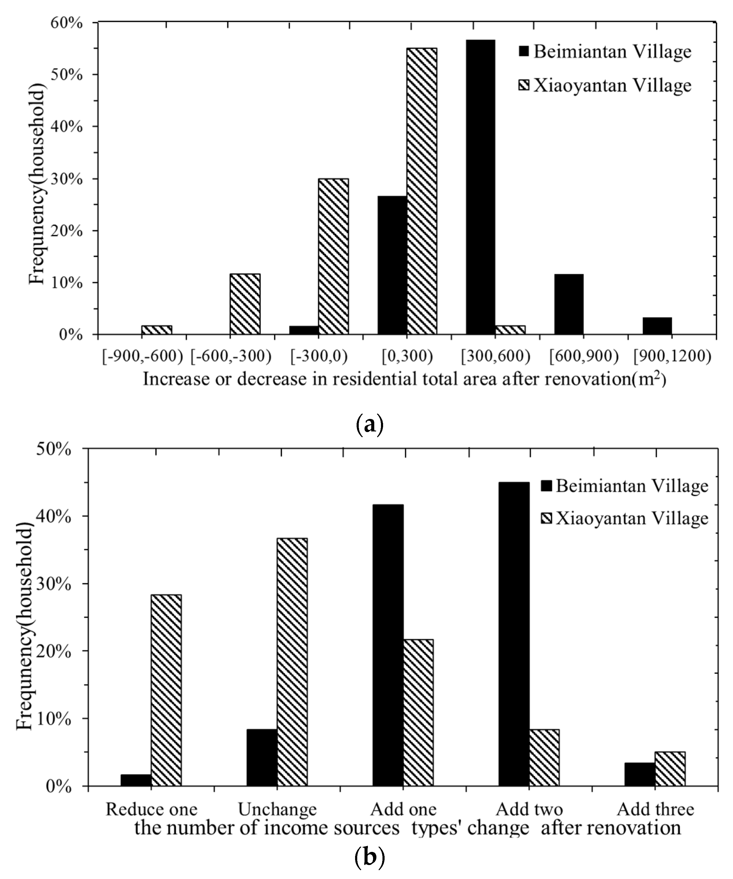
| Total housing area after reform | Increased | 98% | Increased | 53% | ||||
| Unchanged | 1% | Unchanged | 8% | |||||
| Decreased | 1% | Decreased | 39% | |||||
| Resettlement and compensation pattern | Currency resettlement | 68% | Housing resettlement | 54% | ||||
| Combination of currency and physical resettlement | 32% | Surplus housing area discount currency placement | 46% | |||||
| Income condition | Increased | 93% | Decreased | 7% | Increased | 28% | Decreased | 72% |
| Consider the source of income that promotes income growth | House rental economy | 93% | House rental economy | 82% | ||||
| Leaving village for jobs | 4% | Leaving village for jobs | 12% | |||||
| Village organization employment | 3% | Self-employed shop stalls | 6% | |||||
| Exist leasing economy and revenue situation | Existing | 100% | Existing | 73% | ||||
| Exist, increased in revenue | 97% | Exist, increased in revenue | 34% | |||||
| Exist, decreased in revenue | 3% | Exist, decreased in revenue | 66% | |||||
| Housing status sustainability | Average value | Standard deviation | Average value | Standard deviation | ||||
| HOI | 4.00 | 0.21 | 3.80 | 0.41 | ||||
| HCI | 5.18 | 0.81 | 5.40 | 0.85 | ||||
| HPI | 6.12 | 0.76 | 5.62 | 1.03 | ||||
| HFI | 0.83 | 0.54 | 0.63 | 0.87 | ||||
| HQI | 12.63 | 1.57 | 10.52 | 2.89 | ||||
| NRCM(BNV) | D/RMM(XV) | |||
|---|---|---|---|---|
| Before | After | Before | After | |
| Self-owned house rentals | 3.33% | 96.67% | 61.67% | 61.67% |
| Leaving village for jobs | 15.75% | 19.17% | 17.35% | 70.23% |
| Village collctive employment | 2.50% | 21.67% | 1.67% | 1.67% |
| Village collective shares and dividends | 1.67% | 85.83% | 3.33% | 85.00% |
| Government subsidy | 1.67% | 5.00% | 1.67% | 23.33% |
| Self-employed shop stalls | 3.33% | 21.24% | 1.67% | 15.20% |
| Agricultural planting | 76.67% | 0% | 65.00% | 3.33% |
| Independent Variable | Model One. NRCM(BNV) | Model Two. D/RMM(XV) | ||||||||||
|---|---|---|---|---|---|---|---|---|---|---|---|---|
| F1 | F2 | F3 | F4 | F5 | F6 | F1 | F2 | F3 | F4 | F5 | F6 | |
| Realty management | 0.346 | 0.563 | 0.726 | 0.115 | 0.065 | 0.271 | 0.554 | 0.565 | −0.203 | 0.081 | −0.218 | 0.076 |
| Public facilities supporting | 0.663 | 0.263 | 0.907 | 0.413 | 0.018 | −0.2 | 0.515 | 0.736 | −0.277 | −0.085 | −0.512 | 0.141 |
| Landscape greening | 0.631 | 0.136 | 0.816 | 0.048 | 0.447 | −0.325 | 0.398 | 0.689 | −0.502 | −0.245 | −0.304 | 0.028 |
| Community security | 0.268 | 0.6 | 0.72 | −0.263 | 0.506 | −0.161 | 0.557 | 0.551 | −0.635 | 0.276 | 0.224 | −0.142 |
| Community public places | 0.227 | −0.461 | 0.815 | −0.183 | 0.225 | 0.138 | 0.046 | 0.813 | 0.505 | 0.635 | −0.437 | −0.146 |
| Convenience of public transport | −0.161 | 0.169 | 0.666 | 0.844 | 0.143 | −0.007 | 0.636 | −0.364 | −0.265 | 0.017 | 0.817 | 0.026 |
| Distance from the city center | −0.504 | −0.349 | −0.205 | 0.761 | −0.156 | 0.195 | 0.541 | −0.335 | −0.429 | 0.019 | 0.869 | −0.412 |
| Commuting status | 0.372 | 0.586 | 0.411 | 0.886 | 0.384 | 0.216 | 0.427 | −0.404 | −0.158 | 0.374 | 0.927 | −0.503 |
| Stability of income sources | 0.701 | −0.091 | −0.26 | 0.698 | 0.153 | 0.489 | 0.832 | −0.156 | −0.039 | −0.458 | 0.441 | 0.487 |
| Work intensity and tiredness | 0.799 | 0.104 | 0.418 | −0.659 | −0.056 | 0.18 | 0.748 | 0.134 | 0.617 | 0.566 | −0.036 | 0.495 |
| Income increase or decrease situation | 0.856 | 0.715 | −0.415 | 0.028 | 0.591 | 0.017 | 0.824 | 0.071 | 0.238 | 0.426 | 0.433 | −0.312 |
| Friendliness of community members | 0.222 | 0.738 | 0.066 | −0.178 | −0.071 | 0.482 | 0.607 | 0.238 | 0.545 | 0.773 | −0.046 | 0.154 |
| Scope of making friends in the community | 0.17 | 0.822 | 0.067 | 0.288 | −0.266 | 0.153 | 0.147 | 0.454 | 0.316 | 0.853 | 0.484 | −0.068 |
| Acquaintance social reservation situation | 0.441 | 0.801 | −0.084 | 0.371 | −0.532 | 0.013 | 0.262 | −0.354 | 0.499 | 0.689 | −0.335 | −0.231 |
| The impact of social networks | 0.46 | 0.769 | 0.182 | −0.188 | 0.361 | 0.198 | 0.454 | 0.382 | 0.534 | 0.824 | 0.045 | −0.123 |
| Coverage degree of self-owned insurance | −0.227 | 0.019 | 0.284 | 0.632 | 0.769 | 0.185 | −0.184 | −0.244 | 0.922 | 0.347 | −0.481 | 0.424 |
| Guarantee level of self-owned insurance | 0.368 | −0.215 | 0.342 | 0.164 | 0.824 | −0.316 | 0.533 | −0.359 | 0.906 | 0.105 | −0.343 | −0.262 |
| Satisfaction degree of settlement mode | 0.408 | −0.282 | −0.154 | 0.112 | 0.08 | 0.757 | 0.469 | −0.073 | 0.413 | 0.055 | 0.181 | 0.762 |
| Willingness of residence and old-age care | 0.545 | −0.431 | 0.074 | 0.084 | 0.054 | 0.633 | 0.589 | −0.328 | 0.204 | 0.009 | 0.198 | 0.813 |
| Characteristic value | 2.761 | 2.057 | 1.561 | 1.449 | 1.319 | 1.26 | 3.57 | 2.505 | 2.034 | 1.516 | 1.393 | 1.23 |
| Variance contribution rate (%) | 26.275 | 18.393 | 13.548 | 10.219 | 8.554 | 6.63 | 30.648 | 20.307 | 17.077 | 10.308 | 8.738 | 5.721 |
| Accumulated variance contribution rate (%) | 26.275 | 44.668 | 58.216 | 68.435 | 76.989 | 83.619 | 30.648 | 50.955 | 68.032 | 78.340 | 87.087 | 92.799 |
| Average score (to measure sustainability) | 52.112 | 58.726 | 34.539 | 23.676 | 19.598 | 28.745 | 22.541 | 25.454 | 50.655 | 31.448 | 45.36 | 15.865 |
© 2019 by the authors. Licensee MDPI, Basel, Switzerland. This article is an open access article distributed under the terms and conditions of the Creative Commons Attribution (CC BY) license (http://creativecommons.org/licenses/by/4.0/).
Share and Cite
Yang, Y.; Liu, Q.; Wang, M. Comparing the Residential Sustainability of Two Transformation Models for Chinese Urban Villages: Demolition/Relocation Market-Oriented and New Rural Construction. Sustainability 2019, 11, 4123. https://doi.org/10.3390/su11154123
Yang Y, Liu Q, Wang M. Comparing the Residential Sustainability of Two Transformation Models for Chinese Urban Villages: Demolition/Relocation Market-Oriented and New Rural Construction. Sustainability. 2019; 11(15):4123. https://doi.org/10.3390/su11154123
Chicago/Turabian StyleYang, Yongchun, Qing Liu, and Meimei Wang. 2019. "Comparing the Residential Sustainability of Two Transformation Models for Chinese Urban Villages: Demolition/Relocation Market-Oriented and New Rural Construction" Sustainability 11, no. 15: 4123. https://doi.org/10.3390/su11154123
APA StyleYang, Y., Liu, Q., & Wang, M. (2019). Comparing the Residential Sustainability of Two Transformation Models for Chinese Urban Villages: Demolition/Relocation Market-Oriented and New Rural Construction. Sustainability, 11(15), 4123. https://doi.org/10.3390/su11154123