Article

Effectiveness of Ring Roads in Reducing Traffic Congestion in Cities for Long Run: Big Almaty Ring Road Case Study

by
Assel Nugmanova
1,
Wulf-Holger Arndt
2,
Md Aslam Hossain
1 and
Jong Ryeol Kim
1,*
1
Department of Civil and Environmental Engineering, Nazarbayev University, Nur-Sultan 010000, Kazakhstan
2
Centre for Technology and Society, Technische Universität Berlin, 10623 Berlin, Germany
*
Author to whom correspondence should be addressed.
Sustainability 2019, 11(18), 4973; https://doi.org/10.3390/su11184973
Submission received: 29 May 2019 / Revised: 21 July 2019 / Accepted: 22 July 2019 / Published: 11 September 2019
(This article belongs to the Special Issue Toward Sustainability: Transport Geography and Mobility)

Abstract

:
It is common to increase road capacity by constructing ring roads to reduce traffic congestion in city areas, although this is often found to be ineffective in the long run. Accordingly, this study investigates various traffic congestion management approaches and their effectiveness in major cities, and explores an identical transport problem in Almaty, Kazakhstan: The Big Almaty Ring Road (BAKAD). Several case examples from the existing literature are examined in which various approaches were taken for managing traffic congestion problems, and these approaches are classified into three concepts. The first concept comprises heavy engineering measures such as ring road development, new road construction, expansion of existing roads, etc. Such measures can initially reduce traffic congestion, but often become ineffective with time due to the generation of induced traffic. Many cities have taken Push and Pull measures that ensure more efficient use of existing capacity and have initiated environmentally friendly alternative transportation modes such as decreased car usage; promotion of public transport, biking and walking; minimization of the necessity of people’s movement by changing urban land use patterns; and so on. These approaches have been found to be effective in providing sustainable transportation solutions and are classified as concept 2. Nevertheless, Push and Pull measures might not be enough for managing traffic congestion, and it might be necessary to increase the road capacity through heavy engineering measures, especially if the city experiences heavy transit traffic. This combined approach is categorized as concept 3. Consequently, the BAKAD project is examined under the umbrella of three concepts, and recommendations are provided based on the findings from the experience of different cities and interviews with experts from Almaty city. Both the results and recommendations developed are relevant for this specific case only, and are not necessarily transferable.

1. Introduction

The economic cost and environmental impact of traffic jams in large metropolitan areas are enormous. For example, the Canadian Taxpayer Alliance found that the cost of traffic was more than $1.5 billion annually without considering the economic costs associated with an extensive consumption of greenhouse gases and severe damage to the environment due to smog generated by inefficiently operated vehicles [1]. In Moscow, a driver lost 127 h per year in traffic congestion [2]. Moreover, in Europe, traffic congestion accounted for 20.3% of total green-house gas emissions, where 88.2% of all GHG emissions were CO2. Traffic congestion was also reported as the main source of other air pollutant emissions, such as NOx (58%), NMVOC (18%), CO (30%), SOx (21%), PM2.5 (27%) and PM10 (22%) [3,4]. Many ways to combat traffic congestion have been applied worldwide, and the main goal of these practices is to reduce the time spent on the roads. Traffic engineers see one solution to the congestion problem as the provision of additional road capacity, such as through ring road development, road extension, rail-over-road grade separation, fly overs, intersection improvement, parking lot development, toll road incentives and so on. One of the most widely used mitigation measures in reducing congestion is the construction/development of ring road systems.
Almaty is the most densely populated city in Kazakhstan, with a large number of cars and heavy traffic, which tremendously worsen the current ecological situation. To prevent environmental degradation of the region, as well as to relieve the urban road network in Almaty by diverting transit traffic from it, the Big Almaty Ring Road (BAKAD) project has been initiated. However, the long-term effectiveness of ring road developments in solving congestion problem is mistakenly exaggerated due to the exclusion of induced traffic demand phenomena [5].
In this research, different approaches to reducing traffic congestion and their effectiveness in the long run are investigated for major cities around the world. Accordingly, the objectives of this study are to classify these cities’ traffic congestion reduction plans into different concepts and to compare them to see if building a ring road (bypass) is effective in solving the problem of traffic jams in the metropolitan areas in the long run by means of decreasing through traffic and personal car use. Consequently, the findings will form the basis for recommendations to address identical transport problems in Almaty city, Kazakhstan, considering the new bypass road—the Big Almaty Ring Road (BAKAD) project, which is under construction.

2. Literature Review

2.1. Methods Used to Reduce Traffic Congestion

Polegate, Newbury and other cities in the United Kingdom (UK) and the Netherlands have applied heavy engineering measures only in solving traffic congestion, without any sustainable urban transport policy measures. Heavy engineering measures refer to building a new ring road, a bypass, a tunnel or road widening. It was found that, in cases with application of heavy engineering measures only, there was an initial temporary relief of traffic congestion, until induced traffic filled up the added transport capacity. The evidence of the induced traffic phenomenon is taken from the reports of post-opening project evaluations (POPE, by Highways England) of bypass/ring roads. These POPE reports compared the outturn impacts of new ring and bypass roads with the forecasted values of traffic flows, and environmental and economic impacts. Post-evaluation is conducted one year and five years after the opening of a new road. Figure 1 summarizes the POPE method.
As an alternative method, instead of heavy engineering measures, Hasselt, Hague, Utrecht, Malmö, Seoul, Auckland and other cities applied transportation or travel demand management only, with “Push and Pull measures” for improving traffic congestion. These Push and Pull measures refer to sustainable mobility policy with a coherent set of technological, social and urban design interventions. The components of these measures are shown in Figure 2.
Moreover, Stockholm, Oslo, Helsinki, Milan, Gothenburg, and other cities have used a combination of both heavy engineering measures and complementary Push and Pull measures to solve traffic congestion problems. For example, Stockholm’s plan to reduce traffic congestion consisted of the opening of the southern bypass along with other complimentary measures such as congestion charges, improvement of public transport services, development of pedestrian spaces and application of compact spatial planning.

2.2. Ring Roads against Traffic Congestion

In the 1930s, the first ring roads were built around Berlin, Munich and London. In the past, the development of ring roads was not specifically planned to decrease congestion in Europe, since there were no traffic jams on the roads at that time [7]. Ring roads were intended to “reveal and reinforce organic spatial structure of cities, and to make monumental artefacts” [8]. Moreover, after the Second World War, the number of cars started to increase tremendously, and this boosted the construction of ring roads in many developed countries. Ring roads decentralize traffic movement from the existing, heavily congested, roads in the city centre by providing alternate routes for traffic flows. Consequently, ring roads reduce the congestion by relieving pressure on inner city areas. Moreover, ring roads allow channelling of unwanted traffic flow so that transit cargo flows or other through traffic do not enter the city centre, and do not generate congestion in the core area. The other function of ring roads is to shape the structure of the city, as its urban spatial structure starts to decentralize towards the ring road or exurban areas, and the city expands; at the same time, a ring road provides a physical barrier for the growing city. Nevertheless, suburbanization or turning rural locations into settlements that can be reached only by car increases dependence on cars in cases with limited public transport options. Moreover, the development of ring roads, together with traffic congestion growth in the city centres, has brought about substantial change in the distribution of intra-metropolitan accessibility [9]. “The most accessible points by car are no longer located in the centre of the city; because accessibility is often highest along the orbital corridors, much of the suburban decentralization process has gravitated towards these areas” [9]. Some authors [10] state that construction of ring roads stimulates local business, as ring roads nowadays serve both transport functions and boost business growth, develop economic areas, and decentralize employment from the inner city to exurban locations. Ring roads do not just enhance the accessibility of suburban municipalities; they also increase property values and make them more attractive to investors [11]. Hence, ring roads decentralize activities, and at the same time increase flows between suburbs, causing progressive congestion of these roads. This eventually increases demand for new orbitals farther from the city centre [11]. “A meta-analysis of dozens of studies found that, on average, a 10 percent increase in lane miles induces an immediate 4 percent increase in vehicle miles travelled, which climbs to 10 percent—the entire new capacity—in a few years” [12]. Thus, it can be said that building more ring roads will not actually reduce traffic congestion problems in the long run, but rather will actually induce an increase in new car users and lead to a severely degraded environment due to additional peak-period vehicle travel or “generated traffic”.

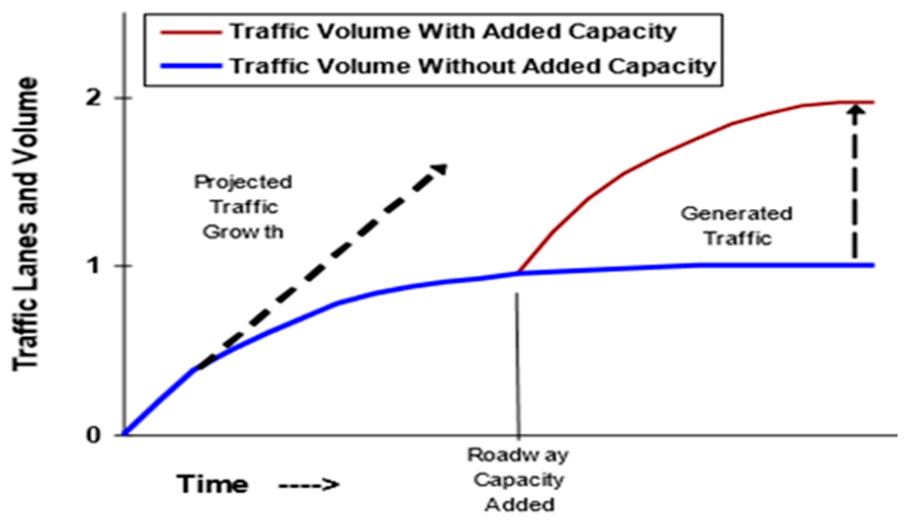
2.3. Generated Traffic

The components of generated traffic due to new road capacity are of two types: diverted traffic that shifts with respect to time, route and destination; and induced traffic, which shifts with regard to other modes, longer trips and new vehicle trips [13]. Generated traffic refers to the statements “the more you build, the more drivers will come” and “roads themselves generate traffic”. Thus, any improvement made to a transport structure, whether it is a widening of an existing road with added lanes or the development of a ring road, will encourage more people to use that new transport facility. At first glance, it seems that the new development provides travel time benefits and better traffic flow [14]. Hence, congestion problems might presumably have been solved. Nevertheless, the new road facility attracts new drivers and changes home/work locations in the long run, which eventually generates new traffic [14]. Therefore, ignoring the long-term effects of induced traffic demand hardly solves congestion problems. For example, one year after opening the North Sea Channel section of the Amsterdam Ring Road, the total number of trips increased by 8%, of which 3% was the result of autonomous growth (2% home–work commuters), and 5% was the result of new drivers accumulated due to improved transport infrastructure; this is considered to be induced demand. Of this 5% induced demand: 2% of car kilometres were due to a shift in routes, 1% was due to passengers who had decided to become drivers, and 2% more traffic was produced by shifts in destination and trip frequency [15]. Furthermore, five years after the North Sea Channel opening, the total number of trips rose to 22%, of which 15% was autonomous growth and 7% was induced demand due to the new road facility [16].
It is crucial to have a clear understanding of the behavioural reactions of drivers to new travel conditions. The list of typical decisions made by vehicle users before they start their journey are: whether or not to travel (trip generation); the best destination to fulfil the purpose (trip distribution); the best time to set out on the journey (trip scheduling); the best mode of transport to use (modal choice); the best route to take (traffic assignment); whether to travel alone or with others (vehicle occupancy); and how often to repeat the journey within a given period (trip frequency) [17]. In the short run, the generated traffic mostly consists of trips diverted from other routes, times and modes, called “Triple Convergence” [18,19]. On the other hand, in the long run, an increasing portion of the generated traffic is from induced travel. Apparently, road capacity expansion leverages automobile-dependent land use patterns [20]. For example, a new highway may encourage companies or households to move to suburban and exurban places where per capita vehicle travel is higher, compared to their previous homes in more accessible and multimodal neighbourhoods.
Moreover, Figure 3 shows that traffic congestion tends to maintain an equilibrium state [21]. Traffic volume increases when roads are uncongested; however, later, the traffic volume’s growth rate declines as roads become congested, and reaches an equilibrium point (where the curve becomes horizontal). As the new capacity is added, the traffic volumes start to increase again until this new equilibrium is reached. This additional vehicle travel is known as “generated traffic” when considering a particular link, and “induced travel” when considering the total vehicle travel [13].
Also, it can be added that short-run generated traffic is demonstrated by the movement along the demand curve: decreased congestion decreases vehicle drivers’ travel costs; however, the total vehicle travel demand is the same. Moreover, long-run induced travel effects are demonstrated by the outward shift as spatial development and transportation patterns become more auto-centric, i.e., extensive car usage is needed to get access to shops, work and other activities. Any road improvement with accurately calculated traffic increase value still will have “an additional or induced 10% of base traffic in the short run” and 20% in the long run [22].
Numerous research studies and transport modelling have shown that adding road capacity provides only a short-term solution to congestion and traffic-related environmental problems. It can be said that the construction of new ring roads must be accompanied by Push and Pull measures that change travel demand and decrease car uses.

3. Methodology

Following a thorough literature review, this study explored several case examples in which various approaches had been taken in managing traffic congestion problems. These approaches were then categorized into three major concepts. A comparative analysis was conducted for these case examples under the umbrella of the three identified concepts. Then, the proposed classification system was investigated for the BAKAD project in Almaty, developing its assessment based on the interview responses of 60 experts. The details of the interviews are discussed later, in Section 6. Subsequently, the necessity of an in-depth analysis of the BAKAD project (the proposed ring road in Almaty), in consideration of both technical solutions and environmentally friendly actions leading to the decrease in private vehicle traffic and the dissemination of other modes of transport, is acknowledged.

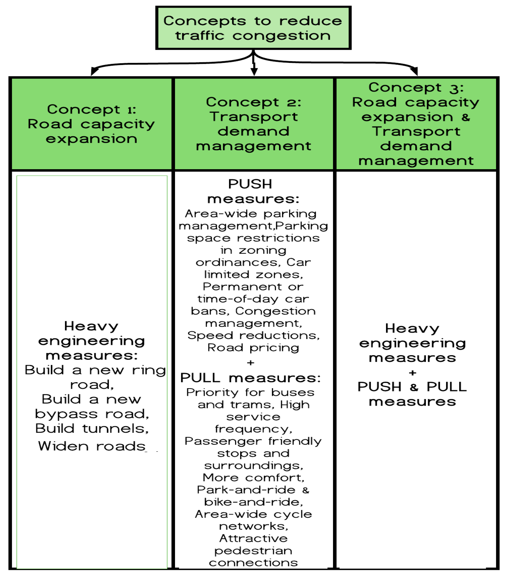
4. Categorization of Methods into Three Concepts

Several cities are compared in terms of traffic congestion decrease, and their traffic congestion reduction methods are categorized into three groups, as shown in Figure 4. Specifically, Polegate and 5 bypasses across the UK, Hasselt and Malmö, Stockholm and Oslo cities are considered in detail. More case studies for each concept are presented in Section 4.4 in tabular form. All these cities have the same objectives as Almaty city, such as improvement of the ecological state of urban and peri-urban areas by reducing the traffic load on the transport system. The reason for having three concepts is to see the different ways in which traffic congestion can be reduced: by adding new road capacity (concept 1), by using transport demand management with Push and Pull measures to reduce car traffic without expansion of road capacity (concept 2), and by combining concepts 1 and 2 (concept 3).

4.1. Concept 1: Heavy Engineering Measures

Polegate Bypass and five other bypasses in the UK were selected based on the availability of official pre- and post-construction monitoring data, and ensuring that sufficient time had passed since construction to allow for post-scheme land use changes to have occurred [23]. These bypass roads had the same objectives as BAKAD does: to divert through traffic from the city and reduce congestion in the city.

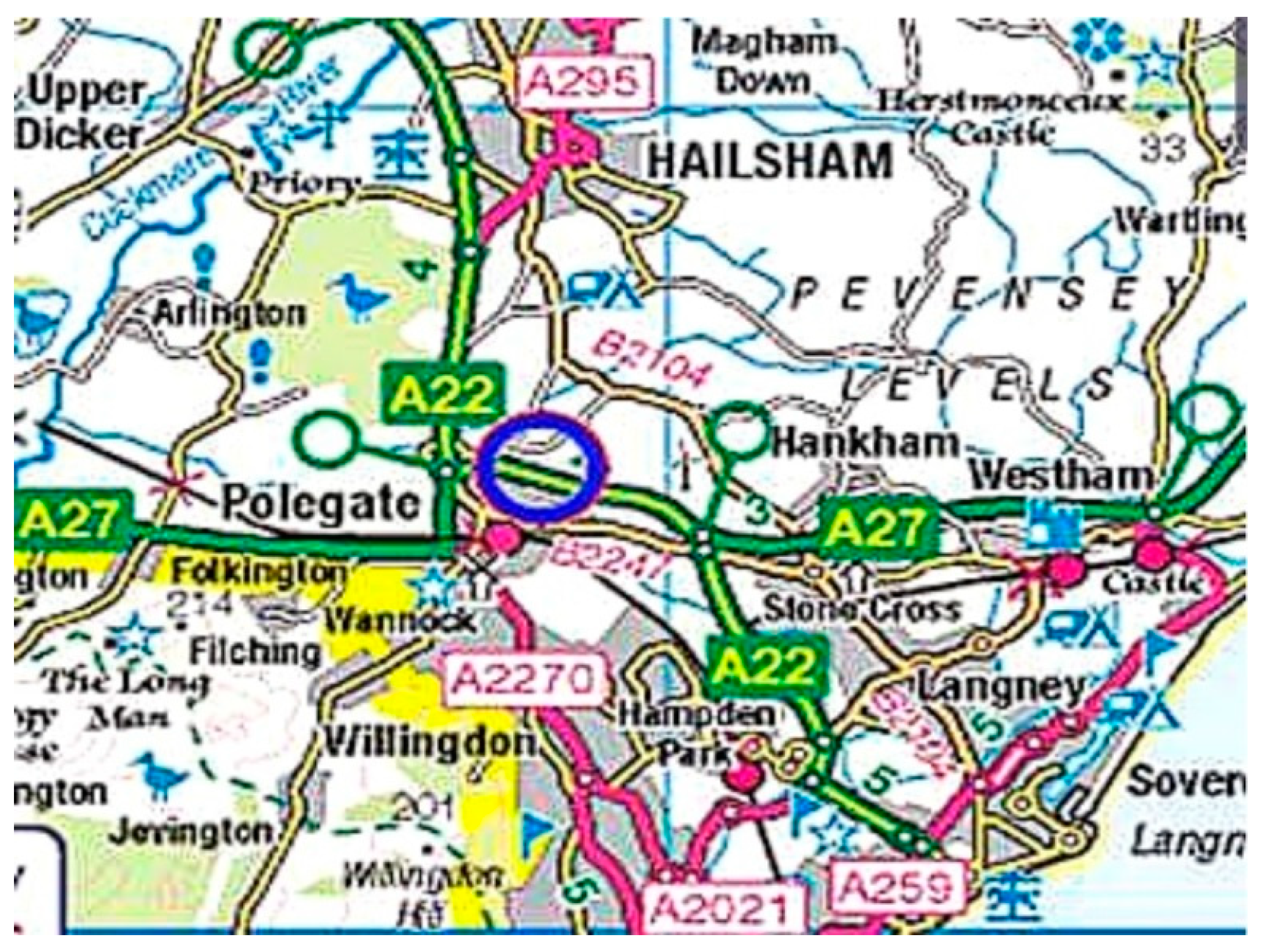
4.1.1. Polegate (United Kingdom)

A27 Polegate Bypass was opened in 2002 and continues as A22 Golden Jubilee Way at its eastern end as shown in Figure 5. A27 Polegate Bypass aimed to provide relief to B2247 and congestion in Polegate city centre, whereas A22 Golden Jubilee Way aimed to relieve heavy traffic from A2270.
It is found that after opening the bypass in 2002, there were signs of induced traffic in 2003, as a 76% overall increase in traffic occurred on the “old” A27 and B2247 routes within one year. Also, there was a relatively small 9% traffic volume increase on the B2247 (city centre) one year after the bypass opening, implying that it was partially effective in city centre traffic reduction [23].
Then, the traffic volume on the A27 and B2247 rose from 50,600 vehicles per day (before opening) to 66,700 vehicles per day five years after the bypass opening, which amounts to a 32% traffic increase after five years [25]. After five years, traffic volume continued to increase on the B2247 (city centre). Traffic volume on the A22 Golden Jubilee road continued to increase as well; moreover, part of this traffic increase was caused by recent developments at the southern end of the A22 Golden Jubilee road [25].
It can be observed that there is a constant traffic generation and that these values are much higher than the forecasted traffic. For example, one year after the bypass opened, the growth of traffic was 27%, and after five years, it was 32%. City roads in Polegate were partially unloaded; however, in a short time, a car regrowth was observed on the old A27 (now B2247) in the city centre. Moreover, it is to be noted that new developments along the roads contributed to the traffic volume increase.
The net effect, in combination with the new road, is a considerable overall increase in traffic. This demonstrates a case of resurgent congestion and it will clearly be a much harder task for the highway authority to reallocate road space [23]. Finally, this case represents Concept 1 and proves the fact that an added road capacity without other travel demand management measures will not be effective in congestion reduction; alternatively, it will encourage induced traffic growth and lead to more congested roads.

4.1.2. Five Bypass Roads (United Kingdom)

The POPE reports for five different schemes (bypasses) across the UK were examined to identify induced demand patterns without considering reassigned traffic growth (people changing their route) or background traffic growth (i.e., that which would have happened with or without the scheme) [23]. The five schemes demonstrated a similar pattern, which is attributed to induced traffic. Table 1 provides a summary of the evidence of induced traffic for the five schemes.

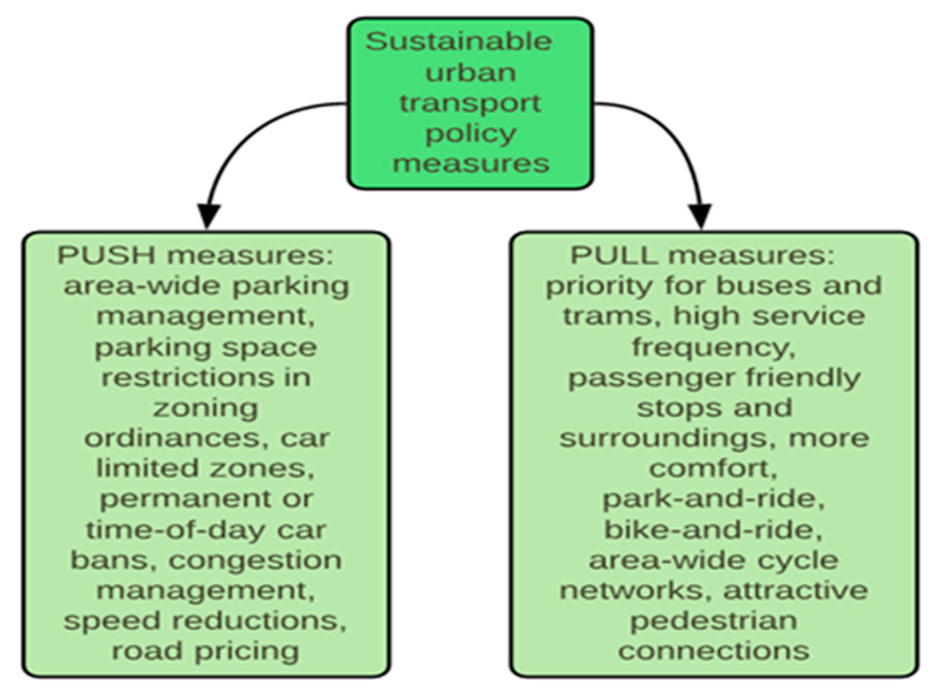
4.2. Concept 2: Travel Demand Management with Push and Pull Measures

The second type of solution for congestion comprises case studies from Hasselt and Malmö, where without introducing heavy engineering measures such as building new ring roads or road improvement, congestion is effectively regulated by means of transportation demand management through Push and Pull measures, carefully balancing the needs of residents, commuters, businesses, visitors and tourists.

4.2.1. Hasselt (Belgium)

The transport strategy in Hasselt included long-term measures such as a Mobility Plan, a Green Boulevard, a public transport policy, spatial planning strategies and separate plans for bicycle use, parking, through traffic, and remodelling of the train station’s forecourt. In addition, the short-term plan included anti-parking bollards, speed-bumps, elevated intersections, and street narrowing. Moreover, there were social campaigns such as car-free days or shopping by bus [26]. One of the strategies was to achieve dense land use around public transport junctions or stations; the other strategy was to decrease the number of empty houses inside the city by introducing high taxes. Furthermore, no development was allowed along the outer ring road to avoid car-oriented land use (sprawl) and, consequently, induced traffic. The Green Boulevard used to be an inner ring road that had carried a large amount of traffic, and was subsequently transformed into a green pedestrian zone that keeps traffic outside the city centre. People leave their cars at parking zones and use free and convenient bus services to reach their final destinations inside Hasselt city. Moreover, car lanes were reduced, and the free spaces were transformed into green areas or cycling lanes. Train stations were remodelled into modern mobility hubs which facilitated modal shifts. Such train station forecourts are now accessible for public transport, bicyclists, wheelchair users and pedestrians. To attract more people to work and live in the inner-city and to minimize personal car use, mixed land-use districts around railway stations were built by providing better availability of daily supplies at the neighbourhood-level [27]. Another spatial planning strategy of Hasselt included bringing life back to the centre by decreasing the number of empty residential units by means of negative taxes, thus preventing urban sprawl, which encourages extensive car use.
Along with many Push and Pull measures, Hasselt has become popular due to its innovative public transport policy, which promoted free-of-charge bus services from 1997 until 2014. Moreover, the quality of the bus stops, with heated, tidy rooms and convenient wash room facilities, was high, and therefore attractive for bus users. There are many bicycle racks and guarded bicycle sheds with showers and cloakrooms across the city to promote cycling. Shopping areas are car-free zones, and numerous bollards in such areas make even cyclists and bus passengers become pedestrians. The new bus system alone was successful in cutting 28,529 trips through Hasselt’s city centre per month [26]. Immediately after the introduction of the free-of-charge bus policy in 1997, around 12,000 people per day started to use buses, compared to the previous value of 1000 bus passengers [28]. Accordingly, as can be seen in Figure 6, free-of-charge buses in Hasselt transported around 4.6 million travellers annually in 2006 compared to 1.5 million bus users in 1997 [29]; 16% of bus users were former car drivers, 12% were former cyclists and 9% were former pedestrians [26].
Hasselt’s case clearly demonstrates that traffic congestion can be managed without heavy engineering solutions such as building a bypass, ring road or other traditional transport infrastructure facilities that generate induced traffic.
It should be added that Hasselt terminated free of charge public transport in 2014. However, ticket prices today are cheaper than those before the introduction of ticketless public transport. As described above, this measure was only one of many in the strategic plan to reduce car traffic. Hasselt’s case clearly demonstrates that traffic congestion can be managed without heavy engineering solutions such as building a bypass, ring road or other traditional transport infrastructure facilities that induce traffic.

4.2.2. Malmö (Sweden)

In the 1980s, the city of Malmö was a traditional car-centric city; however, it subsequently rejected a large-scale road project and adopted a Sustainable Urban Mobility Plan (SUMP). Since then, Malmö city has become a top bicycle city in Europe, with 30% of its residents using bicycles to reach their workplaces. It has a 500 km cycle path network, and the bike and ride parking facility at Malmö’s central station, in particular, is outstanding [30]. This bike station can be used for free 24/7, and it has the capacity to accommodate more than 1500 bikes, together with bike racks. Also, there are restrooms, bike shops, lockers and a waiting lounge with numerous screens showing train departure and arrival times, and air pumps [30]. This bike and ride station is located right under the bus station and connects with the train platforms to assist multimodality. Moreover, 24-h safety is guaranteed by station guards. The main idea is that one can reach the central station using a bicycle and then leave it at the bike and ride parking station, and then continue the trip either by bus or by train following routes and travel times on the LED screens installed inside the station. The other important element of SUMP in Malmö city is its Bus Rapid Transit (BRT) [30]. The BRT system represents 24-m-long hybrid (biogas-electric) busses that run on special bus lanes. Major bus stops along the route were rebuilt, and a traffic signal priority system was installed. Therefore, passenger capacity has been increased; while the travel times and traffic emissions have been decreased [30].
Finally, it is important to note that Malmö city’s travel demand management with Push and Pull measures was found to be very effective in decreasing private car usage, despite the increase in the city’s population. As can be seen in Figure 7, the amount of individual car traffic decreased by 6% in the period of 2006 to 2011 against a population increase of 9% and an increase of workers by 15% [30,31]. During this time period, a significant shift to other transport modes such as bicycle, bus and train was observed.

4.3. Concept 3: Combined Heavy Engineering Measures and Travel Demand Management with Push and Pull Measures

The third type of solution for dealing with congestion is a combination of heavy engineering and sustainable complementary measures. The example of Stockholm’s plan to reduce traffic congestion is considered, where, together with the Southern bypass opening, other measures such as congestion charges and improvement of public transport services, development of pedestrian spaces and application of compact spatial planning are recognized as being effective for confronting traffic congestion and environmental pollution.

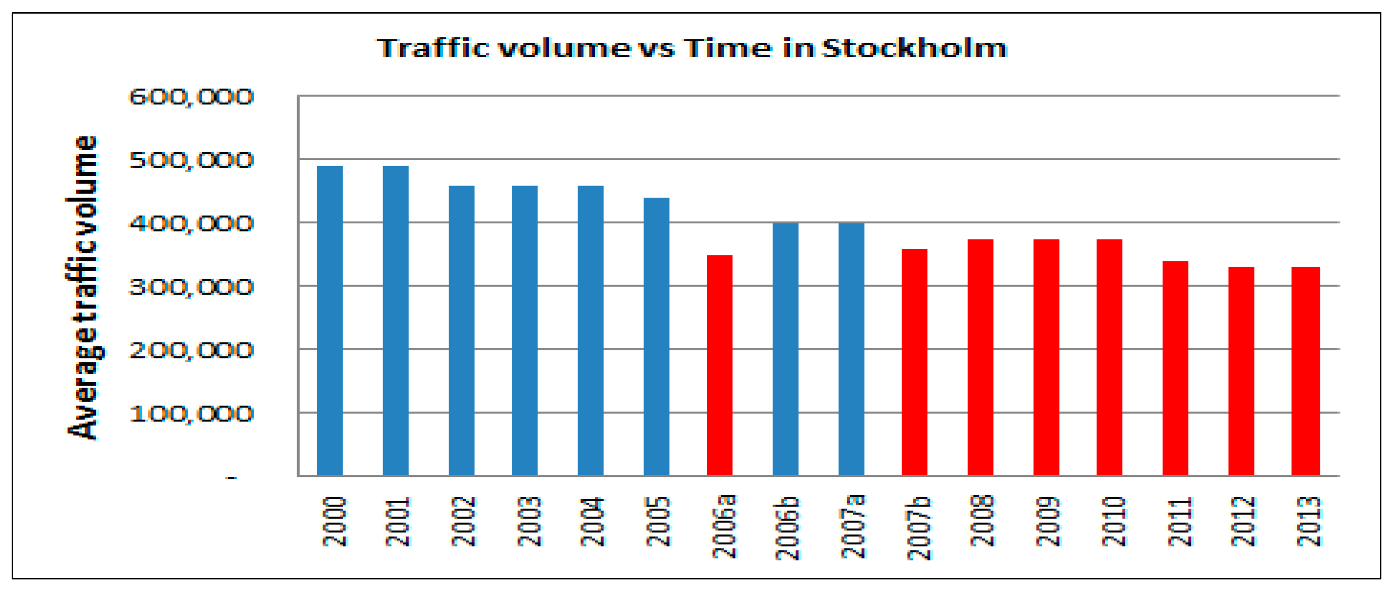
4.3.1. Stockholm (Sweden)

In Stockholm, together with the Southern bypass opening, other measures, such as congestion charges (toll) and improvement of public transport services, development of pedestrian spaces and application of compact spatial planning are recognized as effective in confronting traffic congestion. The Southern bypass was constructed to unload inner city traffic. Moreover, congestion charges (toll) were introduced, along with improvement of public transport capacity to restrain car traffic. In the 1970s, there was rapid traffic growth throughout the inner city until the 1990s; afterwards, and for the next 15 years, the traffic volume unexpectedly remained the same; then, in 2006, a time-differentiated toll around the inner city was introduced [32]. In addition, there was an exemption for alternative-fuel cars (propelled by ethanol, biogas or hybrids) that stimulated the growth of such car ownership (from 3% in 2006 to 15% in 2009) [33]. At the same time, the Essinge bypass was opened, which was free of charge. Figure 8 shows the average daily traffic volume across the inner city (weekdays 6:00–19:00) since 2000.
As can be seen, from the 1990s until 2004, traffic across Stockholm remained constant due to reduced traffic demand (unchanged road capacity). The blue colour indicates that there were no toll charges in this time period, whereas the red colour depicts the traffic volume when there were charges. There was a slight decrease in traffic congestion in 2005 due to the opening of the bypass. Then, in 2006, there was a sharp decrease in traffic due to the combined effect of the bypass opening, congestion charging, and the extension of public transport services. In late 2006 to early 2007, the congestion charging was removed, and traffic volumes started to grow again. As a result, starting from 2007, congestion charging was imposed again to avoid further traffic growth. As can be seen from the red bars, the traffic volume remained constant until 2013. The number of vehicle kilometres decreased by 16% in the inner city; the traffic volume dropped by 5% outside the inner city, on the outlying approach roads, and on outlying streets [32]. Extension of public transit services was also a part of the plan in Stockholm. As a result, the number of drivers switching to public transport services increased by 5% [32]. Hence, it can be concluded that improved quality of public transit services, added road capacity such as bypass and congestion charging, together with promoting the pedestrian mode, can be effective for reducing traffic congestion.

4.3.2. Oslo (Norway)

Oslo city introduced a new urban road tunnel called the “Castle tunnel” or “Festningstunnel” simultaneously with a new toll system that charged drivers entering the city centre of Oslo. This transformed the severely congested square in front of the City Hall into an open space for walking and leisure [34]. Traffic volumes decreased enormously at City Hall square after the opening of the Castle Tunnel (Festningstunnel) and the application of congestion charges. The Oslo toll ring has a classic cordon pricing scheme, with 19 toll stations circling the centre of Oslo [34]. In the first year of Oslo toll ring operation, there was a 3–5% traffic reduction in Oslo [34]. The average number of car crossings through the Oslo toll ring per day for the period 1996–2014 is shown in Figure 9.
As can be seen, after 2007, the number of cars that crossed the toll barrier significantly decreased, despite the population growth during this time period. Part of the explanation for this could be the combined effect of reduced fares for public transport and the improved public transport facilities. The public transport share increased from 21% to 32% between 2005 and 2015, while car ownership decreased from 45% to 34% [36]. In addition, starting from 2017, around 700 parking spots for private cars in the city centre were removed to assist a transition to a car-free city of Oslo. The “Oslo Package” plan is acknowledged as having been a successful and smart tool for funding public transport.

4.4. Effectiveness of the Three Concepts

Table 2 presents a summary analysis of the three concepts discussed earlier, along with a few other supporting case studies for each concept. As can be seen, concept 1 is not effective in the long run, since a significant increase in traffic volume is observed in the case study. Whereas, concept 2 and 3 were found to be effective at reducing congestion by means of a decrease in car use and an increase in the use of alternative modes of transport.

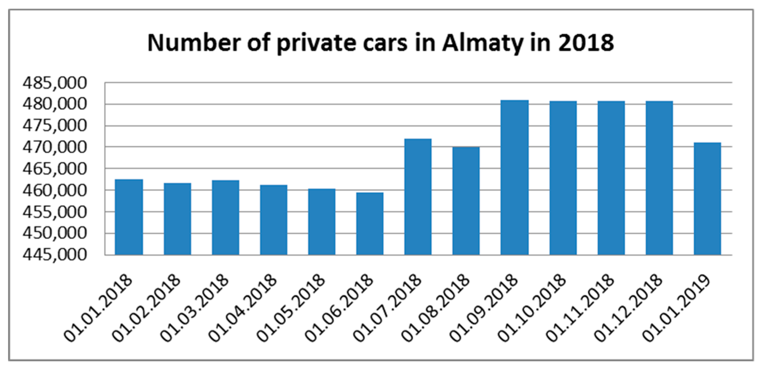
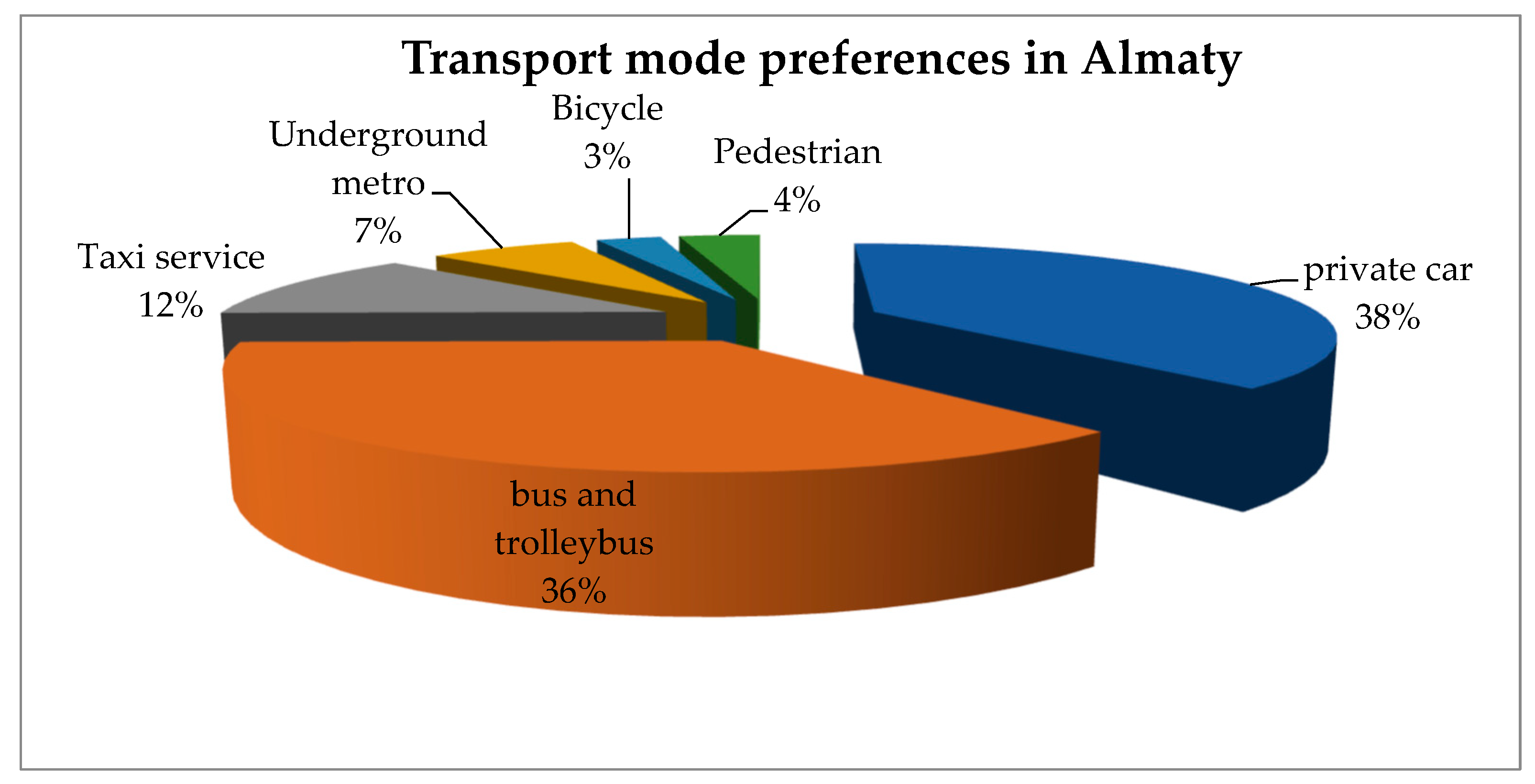
5. Traffic Congestion in Almaty (Kazakhstan)

The total number of inhabitants in Almaty is 1.81 million people. It lies in the northern foothills of the Trans-Ili Alatau at an elevation of 700–900 m. The city is located in a piedmont basin, where fogs and surface inversions are often observed, which makes it difficult to disperse impurities in air. This leads to the accumulation of air pollutants such as exhaust gases from automotive vehicles, emissions from heat stations, co-generation plants, and industrial activities. According to the Centre of Hydro Meteorological Monitoring of Almaty, the index of atmospheric air pollution in the city was 9.2 in 2011—one of the highest in the country [50]. Almaty city and Almaty rural region have the highest number of cars, accounting for 930,761 vehicles [51]. Below, in Figure 10, private car ownership for Almaty city for 2018 is given.
In general, more than 700 thousand units of vehicles are in operation in the city, of which two thirds (250 thousand) are non-resident and transit vehicles [52]. The most preferred transport for moving around the city is a private car (38% of Almaty population are car users), 36% of Almaty residents use bus and trolleybus, 12% use taxi services and 7% use the metro; only 3% of Almaty residents use bicycle, and another 4% do not use any type of transport, as shown in Figure 11 [53].
The route of the first BRT line with a length of 8.7 km was introduced through the streets of Mustafin-Suleimenov-Zhandosov-Timiryazev to Zheltoksan Street in Almaty in 2018. Below, the BRT line on Timiryazev Street is shown in Figure 12.
Due to the overloaded transport system in Almaty, the average driving speed in the city was measured at 19 km/h [54]. The ecological situation is aggravated by the technical condition of the existing fleet of old passenger cars (manufacturing year more than 10 years ago), which accounts for 80.8% of registered passenger cars. Currently, more than 115 thousand technically outdated cars are in operation, providing up to 70% of the gross volume of emissions from motor vehicles [50]. At the same time, 99% of all registered passenger cars use gasoline as fuel. The use of low-quality fuel and lubricants contributes to an increase in emissions of harmful substances into the atmosphere from motorized transport in Almaty. An immediate transition to higher standards of gasoline quality will decrease exhaust emissions produced by cars by 25% in Almaty city [55]. Due to the increase in the standard of living and income growth of Almaty’s population, the mobility of the residents and the level of car ownership will increase, which will put tremendous strain on the city’s transport infrastructure.

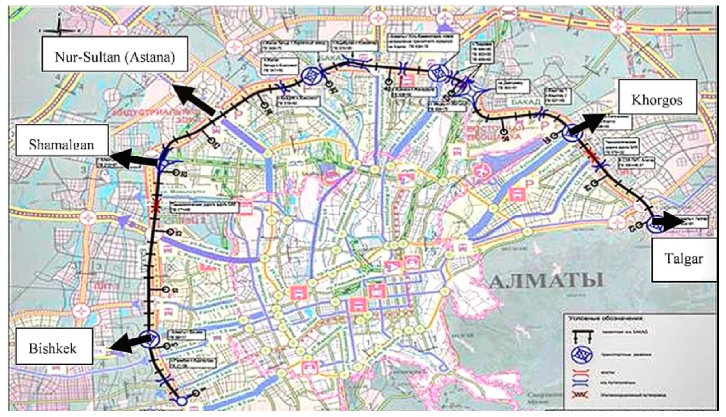
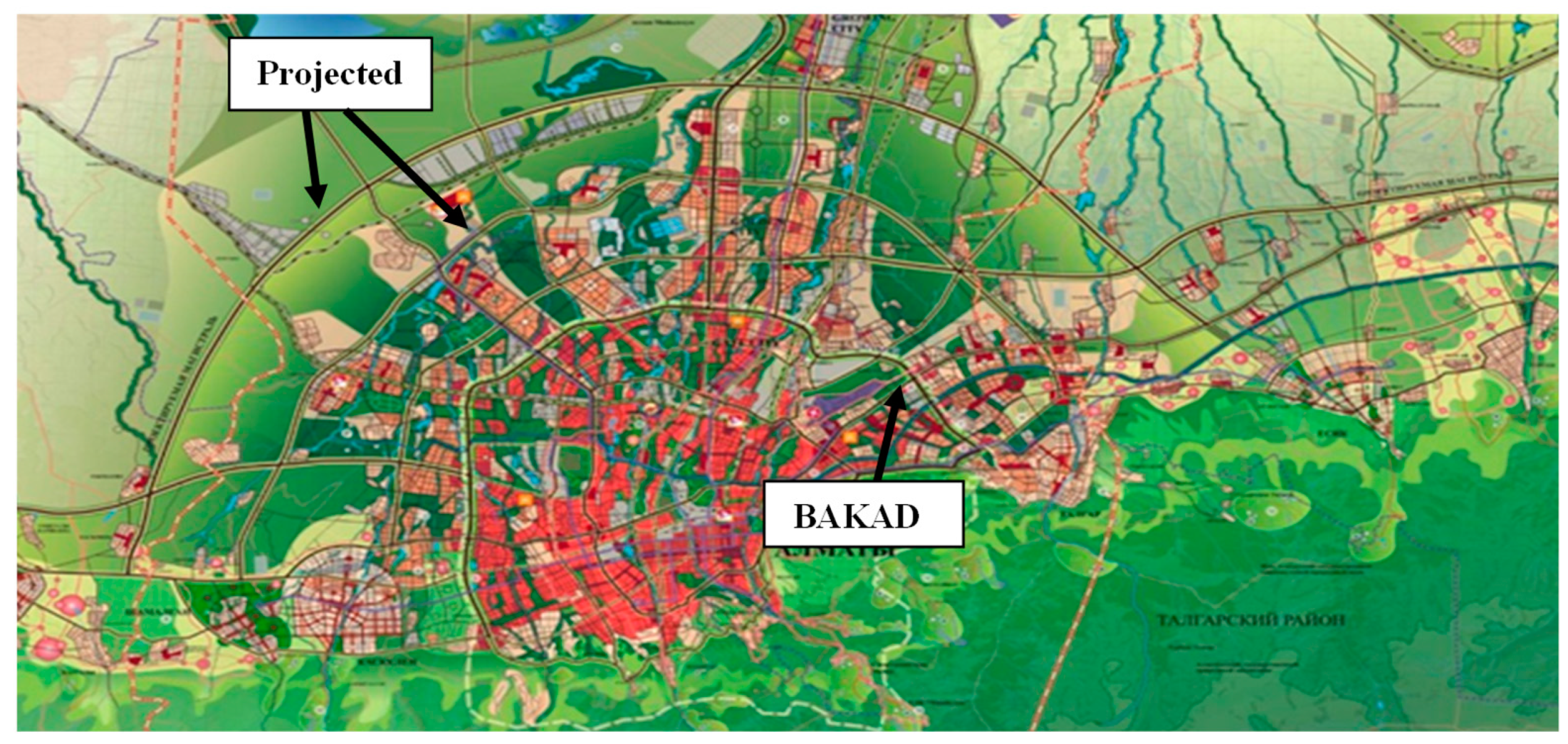
The Big Almaty Ring Road (Kazakhstan)

Considering the huge amount of traffic in Almaty city and the negative environmental impact that it causes, the Big Almaty Ring Road (BAKAD) has been initiated to relieve the urban road network by diverting transit traffic from the city. Transit vehicles pass through Almaty and follow international corridors such as Tashkent–Shymkent–Taraz–Bishkek–Almaty-Khorgos (New Silk Road), and Almaty–Karaganda–Nur-Sultan (Astana)–Petropavlovsk, Western Europe–Western China, as shown in Figure 13.
It is planned to build 8 junctions and 39 overpasses along the BAKAD, which would be a 4- to 6-lane autobahn with a permitted speed of 120–150 km/h. The ring road will be 66 km long, and is planned to be located at a distance of 20–25 km from the centre of Almaty, along its suburban zone through the territory of the Karasai (27.5 km long), Ili (19.26 km long) and Talgar (19.24 km long) districts of the Almaty region [56]. It is expected that BAKAD will ensure improvement of transit capacity and competitiveness of trans-Kazakhstan transit routes.
The annual increase in the intensity of traffic on external roads in the suburban area of Almaty, depending on the direction of the road, is 3% to 8.5% [56]. The transport model of Almaty city was developed by means of PTV Vision VISUM, and the forecasted results of increasing annual average daily traffic intensity along BAKAD (v/day) are shown in Figure 14. It can be seen that the highest traffic volume will occur in 2033 and 2038 on Northern semi-ring–Zhansugurov streets and on Zhansugurov–Lavreneva streets as they are leading to the “Western Europe–Western China” trade corridor and the International Centre for Cross-Border Cooperation “Khorgos”.
It is claimed that “the BAKAD operation will lead to a decrease in traffic jams to the Almaty centre and an increasing in the average speed of motor transport in the city; as a result, there will be a decrease in average fuel consumption, which will lead to a general reduction in greenhouse gas emissions” [57]. Apparently, it seems that the phenomenon of induced demand is neglected in this statement. It is a known fact that new roads generate extra traffic (the figure above demonstrates a vehicle growth on BAKAD). Moreover, rural car-based development might be stimulated. Figure 15 depicts that BAKAD will pass through farmlands (represented by pink colour) and settlements around it (represented by green colour). In addition, Table 3 describes the list of housing developments located along the proposed BAKAD bypass road.
Therefore, the new capacity will encourage extra trips which would not otherwise be made. Also, the car number growth will lead to congestion increase, which will cause an increase in the amount of vehicle emissions. Thus, environmental state might not be improved in the long run. Moreover, GEF/UNDP claimed that “if Almaty follows existing transportation policies when most of the investments are made towards the development of new road networks and personal car use stimulation, by 2023, carbon dioxide emissions from the transport sector in Almaty are expected to grow by 75%” [58].
The actual benefits, as well as the adverse effect of induced traffic can be assessed now for the BAKAD as the project is still under construction. Thus, in order to anticipate whether BAKAD will mitigate traffic congestion in Almaty and improve its current ecological situation in the long run, expert interviews were conducted and matched with the classified concepts (discussed earlier) for the BAKAD.

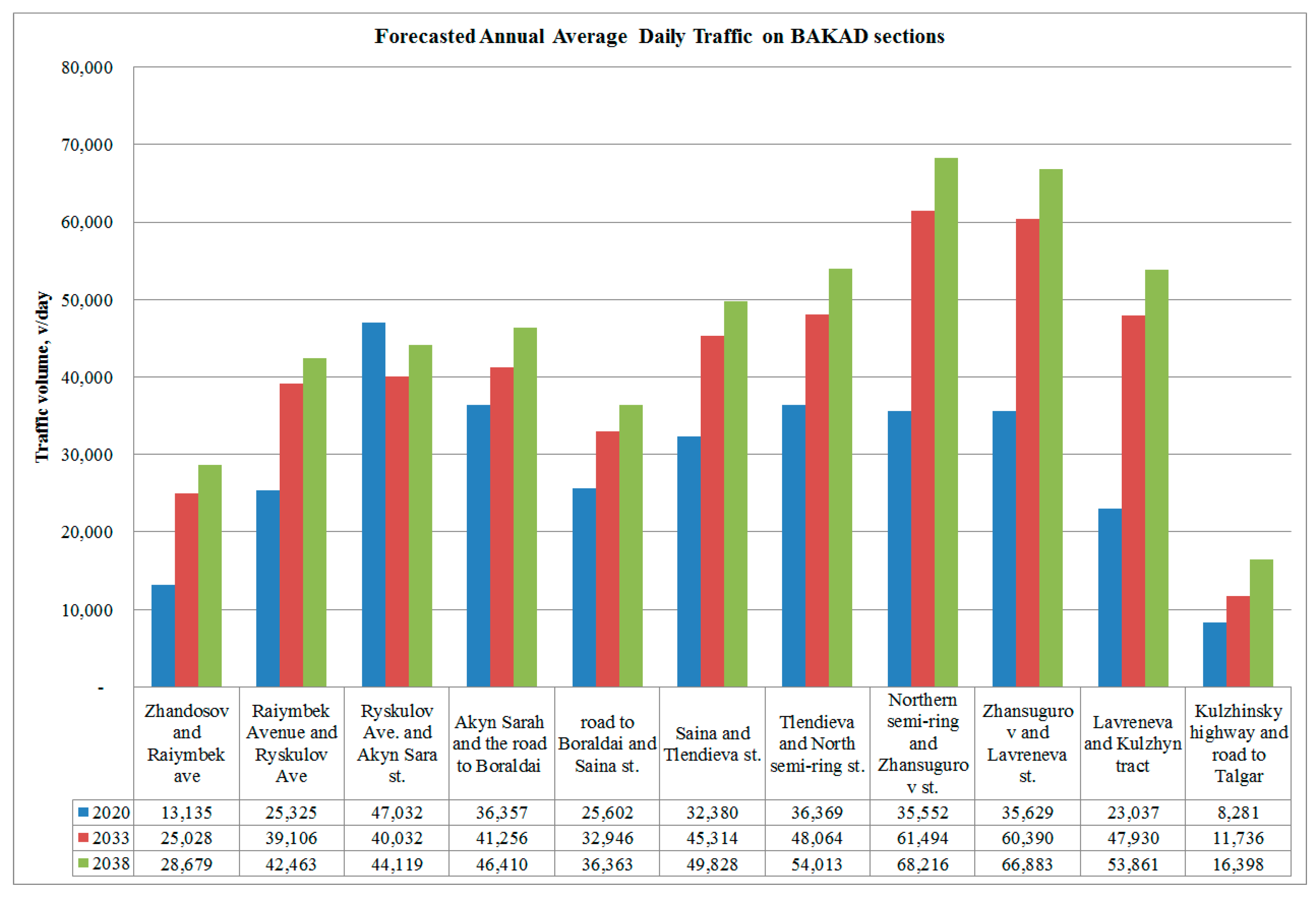
6. Big Almaty Ring Road (BAKAD) analysis

6.1. Expert Opinion on BAKAD

To gather expert opinion on BAKAD and overall congestion management in Almaty city, interviews were conducted face-to-face and over the phone with 60 respondents. Among the respondents, two persons were involved in BAKAD project, and the rest had expertise in highway and traffic engineering, business and finance, and members of the environmental protection community. Furthermore, the majority of respondents were residents of Almaty who were familiar with the Almaty transport system and the local environment. The interview was conducted in a structured format with a fixed number of pre-set questions so that comprehensive opinion could be gathered for each factor. The responses are summarized as follows.
Q1: What will be the results of the BAKAD project in terms of congestion, environmental impact (air quality), and new developments along the BAKAD? Will it solve congestion in the long run in Almaty?
The majority of respondents assumed that an initial relief in traffic congestion would occur due to the operation of BAKAD; however, it would have a temporary effect only. Additional measures such as further construction of metro lines, implying an annual construction of 2–3 stations, commissioning of monorail lines, and an increase in trolleybus lines might solve traffic congestion in the long run. In addition, the switching of all public transport of Almaty to gas, and an upgrade of all of the HPPs in the city by switching them to gas would minimize the harmful impact on the environment.
Currently a large number of drivers from the periphery (exurban areas outside Almaty), for example from Kamenka, Akzhar, Kaskelen, Talgar and other villages in Almaty regional areas, converge on the Almaty city centre every morning and evening, thus creating traffic jams on the road. Almost 200,000 people come to Almaty city daily from nearby exurban regions, and only a negligible number use public transport. Urban sprawl is also induced by the 50% discounts on taxes and insurance for residents from nearby exurban areas of Almaty, which motivates people to live outside the city boundaries, where private cars are the only mode of transport to the city centre. Therefore, BAKAD will designate new borders for the city of Almaty, meaning that the territorial borders of the agglomeration core will be in active growth. Therefore, the previously organized green belts (green lands) around the city will gradually be destroyed in favour of low-rise buildings, as shown in Figure 16, and the dependence on personal transport will also grow. The other problem is that new housing developments, which would mostly be private houses, use coal for heating purposes. Furthermore, new business and industrial developments are expected along BAKAD, which will also stimulate private car ownership. All these facts will influence the development of induced traffic on BAKAD and in Almaty city in the long run and will cause irreparable harm to the environment, imposing damage to the air quality of Almaty.
Q2: Do you know if any developments (housing, business and other) are planned in the BAKAD Project? Will these developments around the BAKAD project stimulate employment?
A majority of respondents claimed that it was planned to locate bus stations, recreational centres, residential and industrial zones, and petrol stations from private owners in the area of the transport interchanges at the entrances to BAKAD. Also, to ensure the operation of the toll highway, a DEU (road maintenance facility) complex with an IPTS (Intelligent Transport Payment System) control centre will be constructed. At radial exits (Almaty-Bishkek, Almaty-Shamalgan, Almaty-Talgar and three other highways), as in Figure 13, construction of large shopping centres (hypermarkets), logistics terminals, industrial zones (factories), and production and distribution centres may be initiated. Also, at a short distance from the BAKAD Ring Road, new residential areas, social and business infrastructure (as residential complexes, business centres, business parks) will be located. Some companies will move their branches from the city centre to the ring road area due to convenient parking and better transport accessibility. Moreover, hotels, gas stations, vehicle repair and maintenance services for transit vehicles on international corridor (Almaty-Ust-Kamenogorsk) and the transcontinental corridor (Western Europe–Western China) will be developed. The respondents agreed that new job opportunities would be created due to BAKAD development. However, if industrial and business sites were to be more concentrated inside the Almaty city, then there would be a risk that these HGVs would enter the city to access industrial and business sites such as warehouses, etc., as happened, for example, in the case of the Newbury bypass, where the old road still experienced high levels of HGVs because of new industrial and business sites accessed via the old road (through the city centre). The other risk is that some drivers might want to skip paying fees for BAKAD and again use the old roads through the city centre, thus resulting in there being no decrease in traffic volume inside the city.
Q3: In your opinion, will the BAKAD ring road cause changes in the behaviour patterns of Almaty inhabitants in the long run? Will there be a new growth of car owners?
All respondents talked about induced traffic demand and believed that there would be recurring traffic congestion on BAKAD and in the city centre. In the short run, this will consist of generated traffic: drivers divert their trips from other routes, times, and destinations. In the long term, the growing number of vehicles will be a result of induced traffic. For example, the post-opening project evaluation of Polegate in the United Kingdom proves the existence of induced traffic growth as described in the section on concept 1. Therefore, considering BAKAD in the framework of the 1st concept findings, it can be assumed that induced traffic will occur after the opening of the BAKAD road.. The parallel routes M36, P19 and outbound roads such as Talgar, Kuljinsky, Iliysky, Almaty–Bishkek might have lower traffic volumes immediately after opening the BAKAD bypass.
According to the responses, BAKAD will make remote areas of Almaty attractive for drivers, and thus they will switch from other alternate routes, times and modes due to the high speed that is possible on it. Moreover, BAKAD will stretch the city and increase its car dependency by expanding residential areas significantly, as mentioned earlier in response of the first question. In connection with the de-urbanization of the city, there will be many new places that can only be reached by private cars.
Q4: Please provide a few methods to destimulate car ownership in Almaty
According to the responses, it is possible to destimulate car use by:
  • building park-and-ride areas (P + R) at the entrances to the city and at metro;
  • increasing the number of suburban bus routes to Kaskelen, Uzyn Agash, Talgar, Esik, Kapshagai from Almaty city and settlements adjacent to the city;
  • launching commuter trains to Uzyn Agash, Kapshagay, Talgar;
  • increasing the cost of parking in the city centre and making the city centre a paid area;
  • organising transport services for students and staff at educational institutions;
  • introducing fines for cars that do not meet Euro 5 fuel standards;
  • developing a convenient bicycle infrastructure in Almaty;
  • providing excellent, low-cost and frequent public transport inside the city and on the outskirts;
  • ensuring a safe licensed taxi service and providing safety in general in the city.
Despite such responses related to building P + R areas, it must be taken into account that such areas, after long-term analyses do not actually decrease car ownership, as a car is still needed to reach the P + R station [59]. Thus, a positive impact of P + R areas is questionable.
All these methods are similar approaches, successfully applied in different cities such as Hasselt and Stockholm, as described earlier. However, further detailed study is necessary to examine the suitability of each method for Almaty city, taking into consideration its current transportation system, socio-economic cultures, land use pattern, people’s behaviour, etc. Furthermore, one respondent suggested following the example of Jakarta’s traffic regulation in Almaty, since the city is heavily car dependent. According to the regulation, each car must have three or more passengers in the central business district of the city during peak hours, otherwise drivers are fined. The respondent claimed that traffic jam in Jakarta increased significantly after the cancellation of this policy in 2016, and average speeds dropped from 28 km/hr to 19 km/hr and from 21 km/hr to 11 km/hr during the morning and evening peak periods, respectively.
Q5: Do you think that the charging system on BAKAD bypass will attract drivers to use it?
According to the responses, it is expected that the cost of travel of 1 km might be equal to 1 KZT for private cars, 5 to 15 KZT for buses depending on passenger capacity, and 5 to 20 KZT for trucks depending on their carrying capacity. Thus, charges on BAKAD ring road will be affordable for potential drivers. However, when considering Oslo city’s mobility plan, with its high tariffs on the Oslo toll ring, it was found that traffic congestion inside the city and personal car ownership on the local roads were effectively decreased, whereas the share of public transport increased (drivers wanted to save money). This means that if the BAKAD tolling system has low tariffs, then this measure will not be effective in achieving the expected results. However, if toll tariffs become unaffordable for drivers, then there is a risk that they may not use the tolled BAKAD road and continue to use old routes, and keep entering the city. The next solution to that might be the inclusion of another toll charge on entry into the city centre. This would encourage drivers (not transit vehicle drivers) to switch to public transport, provided that public transport conditions are improved with competitive fares. For example, in Stockholm, as a result of the tolled cordon around its city centre, the number of drivers switching to public transport services increased by 5%, causing a vehicle traffic reduction of 22% in the inner city.
One respondent added that due to the active transit flow from and to China, the BAKAD project will bring huge profits to the Kazakhstani state budget in the future, as soon as the repayment period for the Concessionaires ends.
Q6: Do you think that the BAKAD project must be a part of an integrated plan to solve congestion problems in Almaty (with other intercity measures such as improvement of public transport, cycling conditions, decreasing car use, road pricing)?
All respondents agreed that BAKAD must be a part of a combined plan with other intercity measures. The city’s urban structure must minimize the need for people to move over long distances, and thus to use private cars. It is necessary to increase the density of the city and to avoid an urban sprawl. One of the respondents provided a detailed plan:
  • Control taxis with proper taxi licenses and designated taxi points. Currently, there are huge numbers of gypsy taxis who stop here and there for passengers and occupy the external lanes, leading to ineffective use of road capacity.
  • Develop a proper transport facility for school-going students. Everyone knows how the traffic flow slows down from 1 September, when classes start for schools. Following the example of the USA, where a couple of buses collect children at special areas at certain time periods, instead of 30 private cars with parents and students occupying the road space and creating traffic congestion, there will be 1 bus on the road.
  • Improve the public transport facilities, develop an underground metro in the city centre, since there is not enough open space.
  • Develop trains from the suburbs (Talgar, Kapchagay, Kaskelen). Although this is expensive, it would effectively replace the huge traffic flow coming from the suburbs to the city centre. A taxi driver can make 2–3 trips every day in the morning from Talgar to Almaty. One train would replace no less than 100 cars.
However, further detailed study is necessary before implementing the aforementioned plans, as mentioned earlier. Many respondents placed an emphasis on improved and friendlier public transport, especially bus services with polite crew (drivers and conductors) so that more passengers are attracted to using public transport, special priority places for pregnant women and older people inside the bus, the need for buses to be convenient for users with disabilities, and a culture of organised boarding of buses must be developed (like in many developed countries, where those who come to the bus station first enter the bus first).
Q7: What would personally motivate you to ride a bike to work?
A majority of respondents stated that the main obstacles to riding a bike to work were: harsh climate conditions in winter, that the city was built on a slope, the illogical and fragmented (incomplete) cycling infrastructure, the lack of safety on roads for cyclists, and there being no priority for cyclists, no barriers for the cycling paths on the road space, no parking facilities for bikes near commercial centres, no shower cabins offered by employers after driving a bike, and no bike promotion programs (e.g., subsidies for purchasing a bicycle, or a rewards per kilometre with a GPS sensor installed in bicycles). Therefore, bikes might not be an effective measure to manage congestion in Almaty.
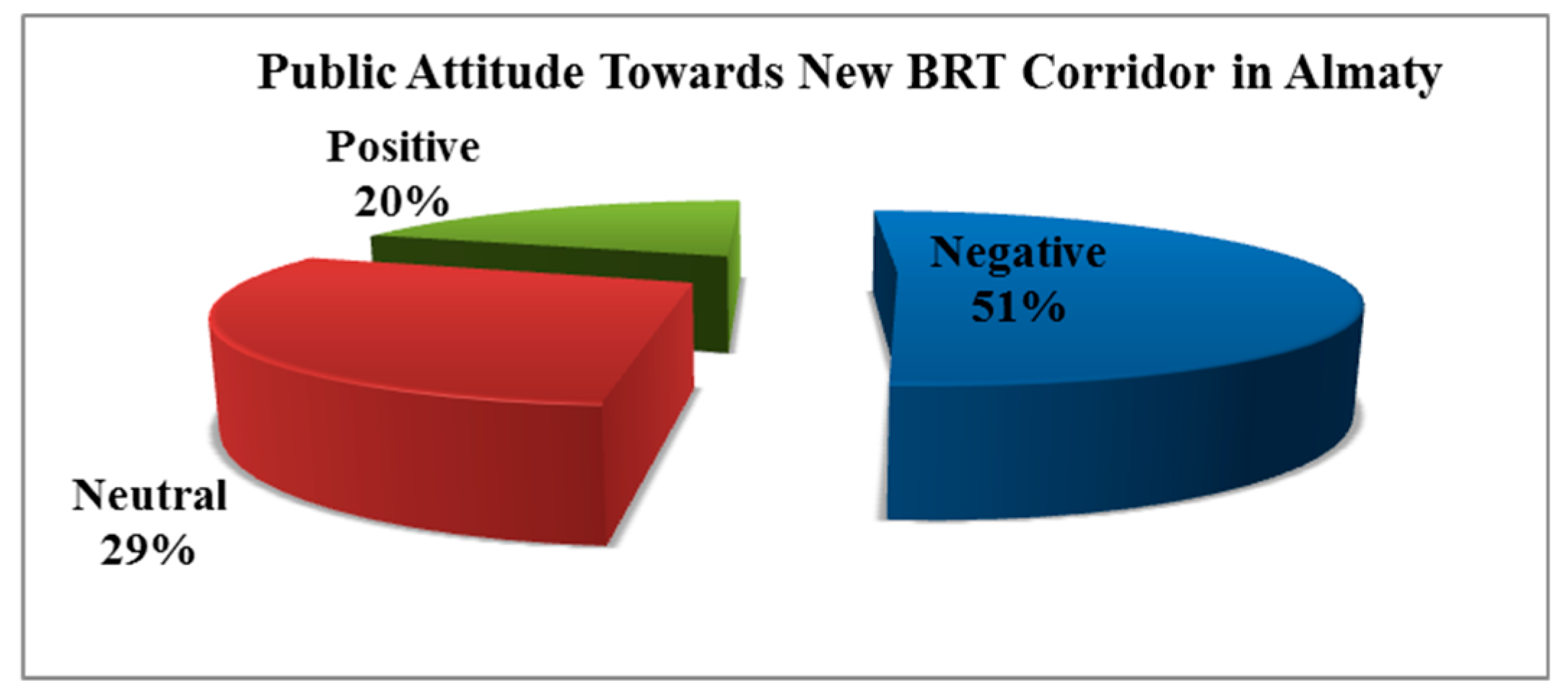
Q8: What do you think of the second BRT corridor that will pass along densely populated streets such as Zheltoksan, Tole bi and the Eastern bypass road to the new bus station on the Kuldzhinsky highway in 2021?
A majority of respondents (51%) from Figure 17 criticized the construction of the 2nd BRT corridor by describing their negative experience of the 1st BRT line on Timiryazev Street, which is still congested. Some of the respondents asked to stop concentrating on the city centre only, and to think of public transport options in the outskirts of Almaty and rural areas around Almaty; furthermore, they stated “why not increase the number of new routes of the underground metro? Its capacity is greater than that of the buses”. Only 20% supported construction of the new BRT line, saying that “Almaty is not for cars, it is for people, our children must grow in a safe city with no car accidents, and thus, public transport (LRT, BRT) is a good solution”. Obviously, due to poor experiences of the 1st BRT line on Timiryazev Street, Almaty citizens are sceptical about reducing traffic congestion by launching the new BRT line.
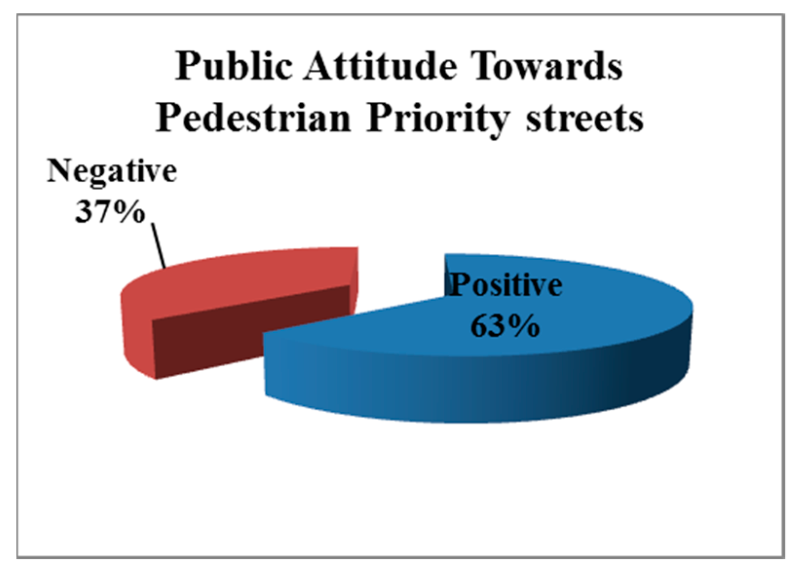
Q9: From the beginning of April 2019, reconstruction work with a priority for pedestrians on the sections of Baiseitova Street, Zhibek Zholy and Dostyk Avenue will start (Figure 18). What is your opinion?
A majority of respondents (63%) as shown in Figure 19 were positive towards turning three city centre streets into pedestrian priority streets. However, some respondents wished to stop doing reconstruction work only in the city centre area, as some districts in the outskirts of Almaty do not have proper roads and roadway lighting.

6.2. Recommendations for Almaty

In the feasibility study, it was assumed that construction of additional outer bypasses around BAKAD would reduce the traffic intensity on it, particularly by removing the transit flow that follows the international transport corridor “Western Europe–Western China”. It can be seen from the master plan of Almaty’s suburban area development (Figure 20) that there will be more ring roads constructed around Almaty. BAKAD will be the nucleus of development, and will generate new trips between the city centre and suburban areas (where the new ring road will be built). Due to these growing travel distances in the non-controlled spatially extended Almaty districts, a great number of private vehicles will cause unsustainable “development of the urban transport system” [59].
Instead of building numerous bypasses around Almaty, approach to the induced traffic problem must be rethought. As was found in the UK case, congestion reduction by extending the road network alone (concept 1) is not effective in the long run. A long-term solution for reducing congestion requires making road space for public transport, pedestrians and cyclists. Therefore, people will switch to more sustainable, space-efficient modes of transport: walking, cycling, buses, trams and trains. These are elements of the 2nd and 3rd concepts of congestion reduction studied in this research, which have been proved to be effective. For instance, Hasselt and Stockholm, which were considered in detail, and the other cities in Table 1 demonstrated sound results in decreasing traffic congestion (car use). The modal shift from driving requires investment in order to improve sustainable transport modes, while at the same time the capacity, access and convenience of urban road networks for motor vehicles must be minimized.
Thus, the following recommendations can be made for Almaty city’s mobility approach:
  • Apply a mixed land use approach to reduce travel distances in Almaty.
  • Develop a centralized spatial planning system that integrates both transport infrastructure and land-use development.
  • Introduce a congestion charge (toll) for driving a car in the city centre, and then the revenues from tolls can be further invested in public transport facilities in Almaty.
  • Ideally, it should be aimed to make the city centre a car-free zone; thus, an excellent public transport alternative must be ensured. For example, in Hasselt city, vehicle drivers are obliged to leave their cars outside the city centre and further reach their destinations by different modes.
  • Start operation of LRT or restore operation of tram infrastructure that was developed during the Kazakh Soviet Socialist Republic period, and increase the routes of the existing underground metro.
  • Increase the number of buses and the frequency of their operation, and ensure that drivers and conductors are trained, polite and helpful to passengers with disabilities in getting into the bus.
  • Add BRT lines on other streets in Almaty and prohibit gypsy taxi services on streets with BRT lines.
  • Reduce the number of parking lots in the city centre and convert them into pedestrian zones. Impose a reasonable charge for parking, with short-term parking only, thereby discouraging car usage.
  • Make cycling lanes safe for cyclists and give priority to cyclists on roads (as several cases demonstrate that buses or private cars take up road space dedicated for cyclists), provide bike parking facilities near commercial, business centres (develop bike promoting programs).
  • Develop train services and increase bus frequencies from the suburbs (Talgar, Kapchagay and Kaskelen) to Almaty to remove the huge traffic flow coming daily from suburbs to the city centre for work and study.
  • An expedited transition to gas of all heat power plants, public transport and residential sector in Almaty and Almaty’s regional area to minimize air pollution. Remove unfit and old cars from roads to minimize air pollution.
  • Organize various promotional and social campaigns such as car-free days, days with free-of-charge bus service, etc.
  • All stakeholders, including Almaty residents, must be involved in the planning process.
  • Develop a shared mobility taxi service to move more people with fewer vehicles; app-based ride-hailing services such as Yandex, Uber, EcoTaxi.kz will need to apply such option for trips in Almaty and Almaty’s regional area.
Finally, it must be admitted that transport infrastructure is a crucial aspect for the economy of Kazakhstan. Considering Kazakhstan as a transit corridor country, and the importance of the strategic location of Almaty, it must develop an adaptive and robust transport infrastructure. Heavy engineering measure such as the BAKAD project is necessary to divert transit vehicles and unload inner city traffic. At the same time, sustainable solutions such as attractive public transport, walkability, compact spatial planning, and restricted car usage in the city centre, as Push and Pull measures must be implemented to manage the traffic congestion in the long run.

7. Conclusions

In this study, various approaches for mitigating traffic congestion in the long run were investigated in several cities and were classified into three concepts. The first concept comprises heavy engineering measures such as ring roads, bypass roads or roadway expansions, which provide short-lived relief to traffic congestion. This approach cannot solve the congestion problem alone, due to induced traffic demand, which might worsen the situation for traffic and the environment in the long run, as added road capacity leads to car-dependent development, which further results in growth of traffic volumes; therefore, a new urban roadway capacity is needed. Hence, alternative strategies that make more efficient use of existing capacity and promotion of alternative modes of transport must be applied in order to reduce congestion. These are known as travel demand management with Push and Pull measures and were categorized as concept 2 in this study. The third concept is a combination of heavy engineering measures and travel demand management with Push and Pull measures; this approach is suitable for cities that need to divert through traffic. The heavy engineering measures are necessary to increase the capacity of existing road(s) and other complementary measures provide more sustainable solutions to the traffic congestion in the long run.
For the traffic congestion problem case in Almaty, it is strongly recommended that the implementation of the BAKAD project will be accompanied by extensive Push and Pull measures. It is anticipated that BAKAD alone will not be sufficient to solve the long-term traffic congestion problem in Almaty. It must be ensured that living and working places are concentrated in the city and are close to public transport facilities such as existing and new rail stations, which are built to corresponding density and urban structure that makes walking and cycling the most preferred mode of transport. Moreover, sufficient funding for high-quality LRT is needed to stimulate rail + bus and rail + pedestrian/cycle travel modes for working and living activities. Also, the removal of private vehicle traffic from the roads by application of travel demand management with Push and Pull measures such as charges for driving in a particular road, charged parking areas for employees and attractive public transport facilities at the same roads is needed. Finally, a major reconsideration of the regulations by which new road projects are appraised must be carried out.
In a nutshell, specific recommendations include reasonable charging systems on BAKAD and in the city centre, improved public transport facilities in the city centre and from suburban areas, discouraging car dependency, control of taxi services including gypsy taxis, promotional and social campaigns such as car-free days, etc. These recommendations are supported by a detailed investigation of the congestion management approaches in many cities around the world and expert interviews related to the BAKAD project and the overall transportation system in Almaty city. However, detailed study must be conducted before implementing any Push and Pull measures. Moreover, appropriate programs to be developed for evaluating post-implementation impacts of BAKAD project and any other complementary measure taken to reduce traffic congestion in Almaty. Based on the data, the effectiveness of the added infrastructure capacity can be assessed, along with other measures, so that corrective actions can be taken, hence improving the traffic congestion. Finally, it should be noted that the results generated in this case study are helpful for this specific case, and the recommendations provided by the authors are not necessarily transferable.

Author Contributions

Conceptualization, W.-H.A., J.R.K., M.A.H., A.N.; methodology, A.N., M.A.H., J.R.K.; investigation, A.N., M.A.H.; resources, J.R.K., W.-H.A.; data curation, A.N., J.R.K., M.A.H., W.-H.A.; writing—original draft preparation, A.N., M.A.H.; writing—review and editing, A.N., W.-H.A., J.R.K.; supervision, J.R.K., W.-H.A.

Funding

This research was supported by the Nazarbayev University Research Fund under Grants #SOE2017003 and Sustainable Urban Mobility Research in Central Asia (SUMRICA) project. The authors are grateful for these sources of support. Any opinions, findings, and conclusions or recommendations expressed in this material are those of the authors and do not necessarily reflect the views of the Nazarbayev University.

Acknowledgments

The authors would like to acknowledge the assistance and contributions of the respondents who participated in the interviews and provided valuable feedback for this research.

Conflicts of Interest

The authors declare no conflict of interest.

References

  1. Snell, S. The Irony of Ring Roads. Available online: https://www.planetizen.com/node/65949 (accessed on 18 October 2018).
  2. Belyanin, A. Incentives, Paradoxes, Failures—The City through the Eyes of Economists. Available online: http://avidreaders.ru/book/stimuly-paradoksy-provaly-gorod-glazami-ekonomistov.html (accessed on 18 October 2018).
  3. Greenhouse Gas Emission Trends—European Environment Agency. Available online: http://www.eea.europa.eu/data-and-maps/indicators/greenhouse-gas-emission-trends/greenhouse-gas-emission-trends-assessment-5 (accessed on 30 September 2018).
  4. Air Quality in Europe. Available online: http://www.eea.europa.eu/publications/airquality-in-europe-2012 (accessed on 30 September 2018).
  5. Hymel, K. If you build it, they will drive: Measuring induced demand for vehicle travel in urban areas. Transp. Policy 2019, 76, 57–66. [Google Scholar] [CrossRef]
  6. Highways England. Post Opening Project Evaluation (POPE) of Major Schemes Main Report. Available online: https://assets.publishing.service.gov.uk/government/uploads/system/uploads/attachment_data/file/497241/POPE___Meta_2015_Final_210116_-_FINAL.pdf (accessed on 30 September 2018).
  7. Hall, P. Keynote Address on Orbital Motorways. In Orbital Motorways, Proceedings of the Conference Organized by the Institution of Civil Engineers, Stratford upon Avon, UK, 24–26 April 1990; Thomas Telford: London, UK, 1990; pp. 1–31. [Google Scholar]
  8. Bruinsma, F.; Pepping, G.; Rietveld, P. Infrastructure and Urban Development: The Case of the Amsterdam Orbital Motorway. Adv. Spat. Sci. 1998, 214–242. [Google Scholar] [CrossRef]
  9. Muller, P. Transportation and Urban form: Stages in the Spatial Evolution of the American Metropolis. Available online: http://www.des.ucdavis.edu/faculty/handy/TTP220/Muller_reading.pdf (accessed on 25 September 2018).
  10. Janas, M.; Zawadzka, A. Analysis of the impact of the Eastern ring road of Lodz on selected components of the environment. E3S Web Conf. 2018, 28. [Google Scholar] [CrossRef]
  11. Martin, J.; García-Palomares, J.; Gutierrez, J.; Román, C. Efficiency and Equity of Orbital Motorways in Madrid. Available online: https://www.jtlu.org/index.php/jtlu/article/view/106 (accessed on 30 September 2018).
  12. Klumpenhouwer, W. Ring Road, More Lanes on Deerfoot Will Not Improve Traffic—Spur the New West. Available online: http://www.spuryyc.org/ring-road-more-lanes-on-deerfoot-will-not-improve-traffic/ (accessed on 18 October 2018).
  13. Litman, T. Generated Traffic and Induced Travel Implications for Transport Planning: Victoria Transport Policy Institute. Available online: http://www.vtpi.org/gentraf.pdf (accessed on 6 September 2018).
  14. Van der Loop, H.; Van der Waard, J.; Haaijer, R.; Willigers, J. Induced Demand: New Empirical Findings and Consequences for Economic Evaluation. Available online: https://trid.trb.org/view/1392603 (accessed on 30 September 2018).
  15. Van der Loop, H.; Haaijer, R.; Willigers, J. New Findings in the Netherlands about Induced Demand and the Benefits of New Road Infrastructure. Transp. Res. Procedia 2016, 1, 72–80. [Google Scholar] [CrossRef]
  16. Jong, G.; Kroes, E. The Impacts of the Amsterdam Ring-Road: Five Years after. Available online: https://trid.trb.org/view/638674 (accessed on 30 September 2018).
  17. Hills, P.J. What Is Induced Traffic? Available online: https://link.springer.com/content/pdf/10.1007%2FBF00166216.pdf (accessed on 6 September 2018).
  18. Downs, A. Stuck in Traffic. Available online: https://www.brookings.edu/book/stuck-in-traffic/ (accessed on 18 October 2018).
  19. Downs, A. The Triple Convergence & Walkable Streets. Available online: https://walkablestreets.wordpress.com/1994/08/18/the-triple-convergence/ (accessed on 29 October 2018).
  20. Hansen, M.; Dobbins, D.; Huang, A.; Puvathingal, M. The Air Quality Impacts of Urban Highway Capacity Expansion: Traffic Generation and Land Use Change. Available online: https://escholarship.org/uc/item/6zz3k76c (accessed on 30 September 2018).
  21. Litman, T. Generated Traffic: Implications for Transport Planning. Available online: https://pdfs.semanticscholar.org/abfb/6589b0995d0e476dbb0c42185d2c415f3b7e.pdf (accessed on 6 September 2018).
  22. Goodwin, P. Induced Traffic Again and Again. Available online: http://stopcityairportmasterplan.tumblr.com/post/19513243412/induced-traffic-again-and-again-and-again (accessed on 1 October 2018).
  23. Sloman, L.; Hopkinson, L.; Taylor, I. The Impact of Road Projects in England; TfQL Community Interest Company: Machynlleth, Wales, 2017. [Google Scholar]
  24. Geograph Map. Available online: http://www.geograph.org.uk/showmap.php?gridref=TQ58640560 (accessed on 18 October 2018).
  25. Post Opening Project Evaluation: Five Year after Study for A27 Polegate Bypass. Available online: http://webcache.googleusercontent.com/search?q=cache:http://assets.highways.gov.uk/our-road-network/pope/major-schemes/A27-Polegate-Bypass/A27%2520Polegate%2520POPE%2520FYA%2520-%2520website%2520version.pdf (accessed on 23 October 2018).
  26. Brand, R. Synchronizing Science and Technology with Human Behaviour, 1st ed.; Taylor & Francis: New York, NY, USA, 2005; ISBN 978-1-84407-251-4. [Google Scholar]
  27. Brand, R. Co-evolution of Technical and Social Change in Action: Hasselt’s Approach to Urban Mobility. Built Environ. 2008, 34, 182–199. [Google Scholar] [CrossRef]
  28. Goeverden, C.; Rietveld, P.; Koelemeijer, J.; Peeters, P. Subsidies in Public Transport. Available online: http://citeseerx.ist.psu.edu/viewdoc/download?doi=10.1.1.526.4244&rep=rep1&type=pdf (accessed on 20 October 2018).
  29. Canters, R. Hasselt Cancels Free Public Transport after 16 Years (Belgium). Available online: http://www.eltis.org/discover/news/hasselt-cancels-free-public-transport-after-16-years-belgium-0 (accessed on 23 October 2018).
  30. Nordin, A. Sustainable Urban Mobility Plan. Available online: https://malmo.se/download/18.16ac037b154961d0287384d/1491301288704/Sustainable+urban+mobility+plan%28TROMP%29_ENG.pdf (accessed on 30 September 2018).
  31. Häkansson, P. Good Practice Example: Sustainable Transports in Malmö. Available online: http://www.special-eu.org/knowledge-pool/module-4-implementation-of-sustainable-planning/mobility/good-practice-example-1-sustainable-transports-in-malmoe (accessed on 30 September 2018).
  32. The Stockholm Congestion Charges: An Overview. Available online: http://www.transportportal.se/swopec/cts2014-7.pdf (accessed on 30 September 2018).
  33. Eliasson, J.; Hultkrantz, L.; Nerhagen, L.; Rosqvist, L. The Stockholm congestion-charging trial 2006: Overview of effects. Transp. Res. Part A Policy Pract. 2008, 43, 240–250. [Google Scholar] [CrossRef]
  34. Warsted, K. Urban Tolling in Norway—Practical Experiences, Social and Environmental Impacts and Plans For Future Systems. Available online: https://www.piarc.org/ressources/documents/281,2.1-Waersted-0405C11.pdf (accessed on 10 October 2018).
  35. Best Practices-Green Oslo-Oslo Kommune. Available online: https://www.oslo.kommune.no/english/politics-and-administration/green-oslo/best-practices/ (accessed on 6 November 2018).
  36. Application Form of Oslo for the European Green Capital Award 2019. Available online: http://ec.europa.eu/environment/europeangreencapital/wp-content/uploads/2017/06/Indicator_2_Local-Transport.pdf (accessed on 4 February 2019).
  37. Matson, L.; Taylor, I.; Sloman, L.; Elliott, J. Beyond Transport Infrastructure: Lessons for the Future from Recent Road Projects. Available online: http://www.transportforqualityoflife.com/u/files/Beyond-Transport-Infrastructure-fullreport%20July2006.pdf (accessed on 30 September 2018).
  38. Utrecht: ‘ABC’ Planning as a Planning Instrument in Urban Transport Policy. Available online: https://p2infohouse.org/ref/24/23345.htm (accessed on 24 October 2018).
  39. Martens, M.J.; Griethuysen, S. The ABC Location Policy in the Netherlands. Available online: https://fenix.tecnico.ulisboa.pt/downloadFile/3779572236303/abc.pdf (accessed on 3 February 2019).
  40. Ministry of Transport and Communications of Finland. Helsinki Region Congestion Charging Study. Available online: http://urbanaccessregulations.eu/images/stories/pdf_files/Helsinki%20report.pdf (accessed on 6 November 2018).
  41. Kane, L.; Behrens, R. The traffic impacts of road capacity change: A review of recent evidence and policy debates. In Proceedings of the South African Transport Conference, Pretoria, South Africa, 17–20 July 2000; Available online: https://www.researchgate.net/publication/308899853_The_traffic_impacts_of_road_capacity_change: A review_of_recent_evidence_and_policy debates (accessed on 22 June 2019).
  42. Kim, S.-H.; Jung, S.-H.; Rowe, P.G. A City and Its Stream: An Appraisal of the Cheonggyecheon Restoration Project and Its Environs in Seoul, South Korea; Harvard Universtiy: Boston, MA, USA, 2010. [Google Scholar]
  43. Seoul Development Institute. Seoul CBD Development Plans Regarding Cheonggyecheon Restoration Project; Seoul Development Institute: Seoul, Korea, 2004. [Google Scholar]
  44. Global Designing Cities Initiative. Available online: https://globaldesigningcities.org/publication/global-street-design-guide/streets/special-conditions/elevated-structure-removal/case-study-cheonggyecheon-seoul-korea/ (accessed on 24 June 2019).
  45. Rotaris, L.; Danielis, R.; Marcucci, E.; Massiani, J. The urban road pricing scheme to curb pollution in Milan, Italy: Description, impacts and preliminary cost–benefit analysis assessment. Transp. Res. Part A Policy Pract. 2010, 44, 359–375. [Google Scholar] [CrossRef]
  46. Carnovale, M.; Gibson, M. The Effects of Driving Restrictions on Air Quality and Driver Behavior. Available online: https://escholarship.org/uc/item/0v8813qm#main (accessed on 22 June 2019).
  47. Borjesson, M.; Kristoffersson, I. The Gothenburg congestion charge. Effects, design and politics. Transp. Res. Part A Policy Pract. 2015, 75, 134–146. [Google Scholar] [CrossRef] [Green Version]
  48. Roads International Case Studies. Available online: http://content.tfl.gov.uk/roads-review-part-a.pdf (accessed on 27 June 2019).
  49. Giap, T.H.; Merdikawati, N.; Amri, M.; Berger, B.H. 2014 Annual Competitiveness Analysis and Development Strategies for Indonesian Provinces. Available online: https://www.worldscientific.com/worldscibooks/10.1142/9822 (accessed on 25 June 2019).
  50. Sultanova, R.; Dautova, A.; Klushina, O. Environmental pollution of Almaty city in Kazakhstan and its effect on the population health. In Proceedings of the 9th International Correspondence Scientific and Practical Conference “Scientific Community of Students of the XXI Century”, Novosibirsk, Russia, 4 April 2013; Available online: https://sibac.info/studconf/natur/ix/32214 (accessed on 5 October 2018).
  51. Ministry of National Economy of the Republic of Kazakhstan. Available online: http://stat.gov.kz/faces/wcnav_externalId/homeNumbersTransport?_afrLoop=168989223412151#%40%3F_afrLoop%3D168989223412151%26_adf.ctrl-state%3Doqrpnnlbb_63 (accessed on 29 October 2018).
  52. JSC «RFCA Rating Agency». Changes in Private Car Ownership in Almaty. Available online: https://kase.kz/files/ra_rfca_reports/rfca_automotive_industry_081117.pdf (accessed on 30 September 2018).
  53. ACT Kazakhstan. Public Transport Research in Almaty. Available online: https://bit.ly/2CtB1Pw (accessed on 22 February 2019).
  54. Daribayev, M. Transport Reforms in Almaty. Available online: https://www.inform.kz/ru/kakie-syurprizy-gotovit-almatintsam-transportnaya-reforma_a3077141 (accessed on 18 October 2018).
  55. Gorozhankin, P. AirKaz.org—Air Pollution in Almaty. Available online: https://airkaz.org/almaty.php (accessed on 18 October 2018).
  56. BAKAD Feasibility Study, 1st ed.; Ministry of Transport and Communication of the Republic of Kazakhstan: Nur-Sultan, Kazakhstan, 2013.
  57. BAKAD PPP Toll Road Project. Available online: https://www.adb.org/sites/default/files/project-documents/49360/49360-001-esia-en.pdf (accessed on 30 September 2018).
  58. Almaty Will Adopt Sustainable Transport Strategy for 2013–2023. Available online: http://www.kz.undp.org/content/kazakhstan/en/home/presscenter/articles/2013/07/30/almaty-will-adopt-sustainable-transport-strategy-for-2013-2023.html (accessed on 9 October 2018).
  59. Arndt, W.-H. The relevance of transport for megacities. In Proceedings of the 13th World Conference on Transport Research, Rio de Janeiro, Brazil, 15–18 July 2013. [Google Scholar]
  60. Official Internet-Resource of Almaty. Available online: https://almaty.gov.kz/page.php?page_id=3200&lang=1 (accessed on 18 October 2018).
Figure 1. Approach to the POPE of major schemes. Source: [6].
Sustainability 11 04973 g001
Figure 2. Push and Pull measures.
Sustainability 11 04973 g002
Figure 3. Roadway capacity effect on traffic volumes. Source: [21].
Sustainability 11 04973 g003
Figure 4. Classification of concepts for reducing traffic congestion.
Sustainability 11 04973 g004
Figure 5. Polegate Bypass location. Source: [24].
Sustainability 11 04973 g005
Figure 6. Number of travellers transported annually by buses in Hasselt. Source: [29].
Sustainability 11 04973 g006
Figure 7. Development of traffic modes and population 2007–2013 in Malmö. Source: [30].
Sustainability 11 04973 g007
Figure 8. Average traffic volumes in Stockholm, weekdays 6:00–19:00. Source: [32].
Sustainability 11 04973 g008
Figure 9. Average number of car crossings through the Oslo toll ring road per day in 1996–2014. Source: [35].
Sustainability 11 04973 g009
Figure 10. Number of registered private cars in Almaty city from January 2018 until January 2019. Source: [51].
Sustainability 11 04973 g010
Figure 11. Transport mode choice in Almaty. Source: [53].
Sustainability 11 04973 g011
Figure 12. BRT line in Almaty in 2018.
Sustainability 11 04973 g012
Figure 13. Big Almaty Ring Road (BAKAD) map. Source: [56].
Sustainability 11 04973 g013
Figure 14. Forecasted results of annual average daily traffic intensity along BAKAD in 2033 (v/day).
Sustainability 11 04973 g014
Figure 15. Big Almaty Ring Road (BAKAD) scheme.
Sustainability 11 04973 g015
Figure 16. Green lands around Almaty in 2019.
Sustainability 11 04973 g016
Figure 17. Percentage of public attitude towards the construction of the 2nd BRT line in Almaty.
Sustainability 11 04973 g017
Figure 18. Zhibek Zholy Street’s visualization model.
Sustainability 11 04973 g018
Figure 19. Percentage of public attitude towards reconstruction of three streets.
Sustainability 11 04973 g019
Figure 20. Master plan of Almaty’s suburban area development. Source: [60].
Sustainability 11 04973 g020
Table 1. Summary of induced traffic for the five schemes. Source: [23].
Road/Scheme NameGrowth in Excess of Average Traffic Background GrowthLikelihood of Induced Traffic
A500 Basford, Hough, Shavington bypass+7.7% in 5 yearsYes
A66 Stainburn & Great Clifton bypass+2.1% or +13.6% in 7 yearsYes
A1 Willowburn–Denwick Improvement+21.8% in 8 yearsYes
A1 Bramham–Wetherby+7.4% in 3 yearsYes
A10 Wadesmill to Colliers End bypass+2.3% or +6.3% in 6 yearsYes
Table 2. Results of three concepts and their effectiveness in congestion reduction.
Concept 1: Heavy Engineering MeasuresConcept 2: Travel Demand Management with Push and Pull MeasuresConcept 3: Heavy Engineering + Travel Demand Management with Push and Pull Measures
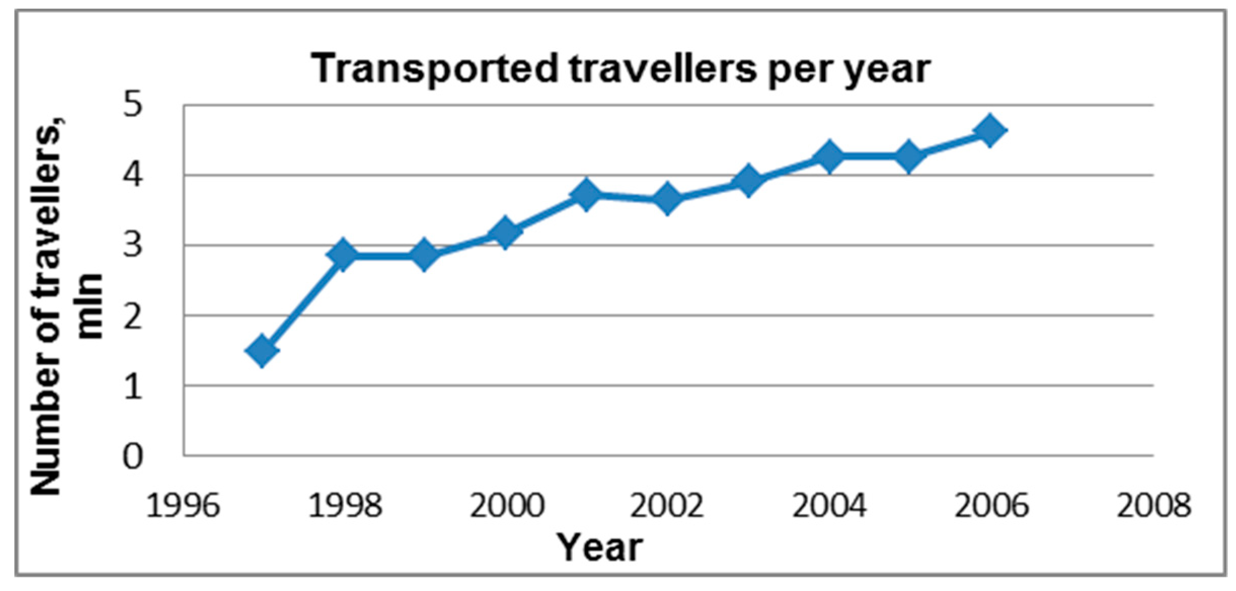
Polegate Bypass: 76% total increase in traffic with 27% induced traffic after one year, and 32% induced traffic after five years.Hasselt: after 1 year 16% switched from car to bus, 12% from bicycle to bus, 9% former pedestrians to bus; By 2006, free-of-charge buses in Hasselt transported around 4.6 million travellers annually versus 1.5 million bus users in 1997Stockholm: Essinge bypass + congestion charges (tolls), expanded bus service decreased the number of vehicle kilometres driven in the inner city by 16%, vehicle-traffic reduction of 22% over the charge cordon
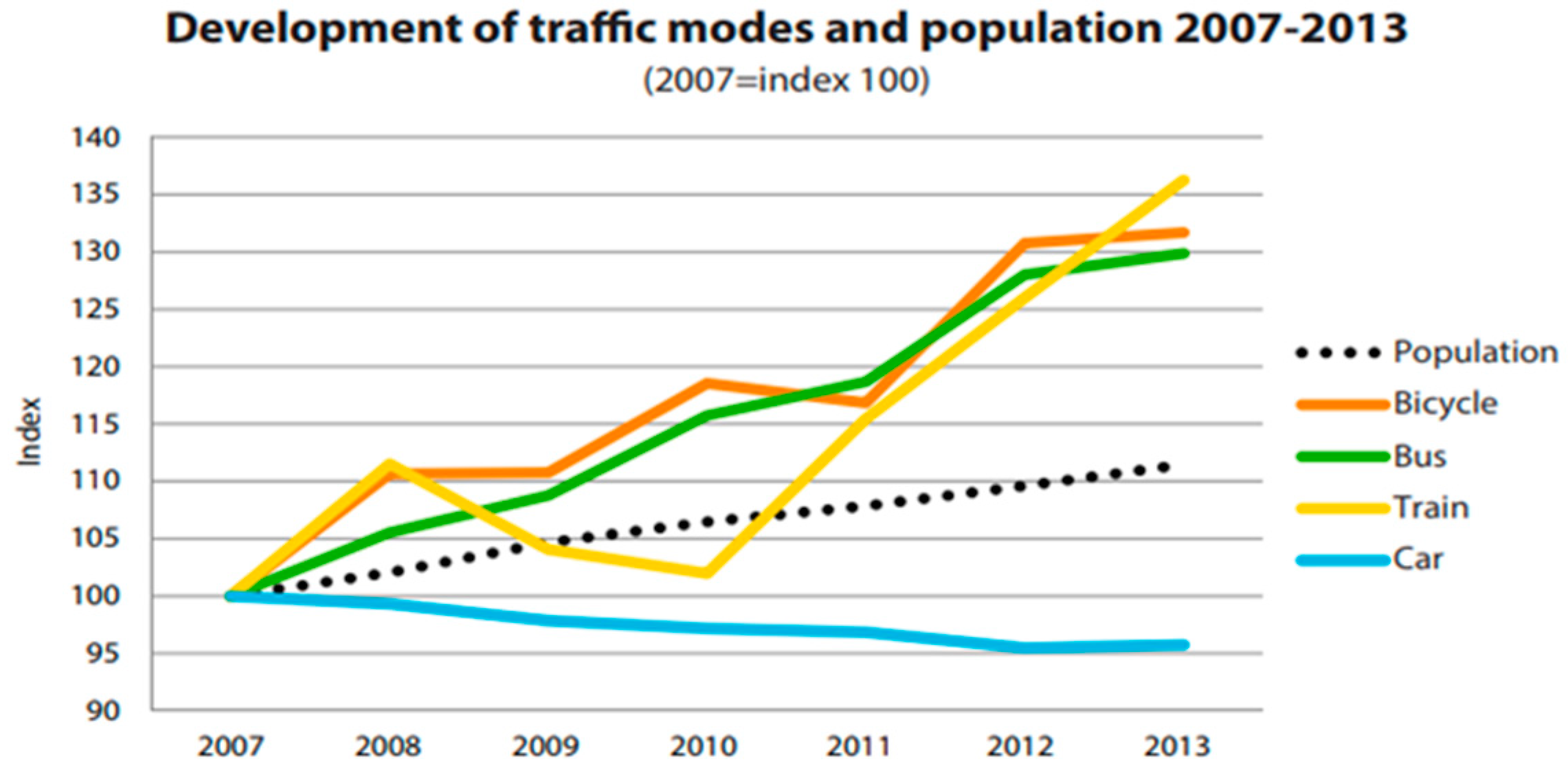
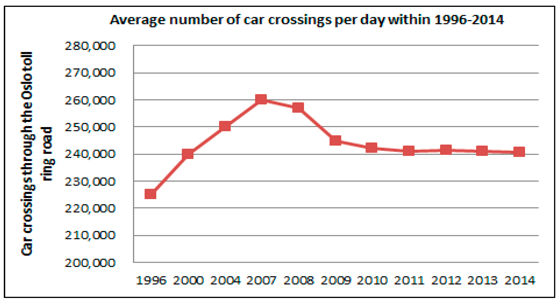
A500 Basford, Hough, Shavington bypass: 7.7% increase in 5 years;
A66 Stainburn & Great Clifton bypass: 13.6% increase in 7 years;
A1 Willowburn–Denwick Improvement: 21.8% increase in 8 years;
A1 Bramham–Wetherby bypass: 7.4% increase in 3 years.
Malmö: 30% of residents use bicycles to reach workplaces; individual car traffic decreased by 6% in the period of 2006 to 2011 against a population increase of 9% and an increase of workers by 15%.Oslo: Festningstunnel + congestion charges in 2005–2015 the public transport share increased from 21% to 32%, while car ownership decreased from 45% to 34%.
Newbury Bypass: FYA: vastly exceeded the HA’s 1995 worst case estimate that there would be no more than 10% induced traffic. Forecasted traffic volume was exceeded by 46% six years before the 2010 prediction [37].Utrecht: increased bicycle use and car sharing by almost 50% and reduced private car use by 14% [38]. Hague: decreased car ownership by 12%, the use of public transport grew from 30% to 65% [39].Helsinki: ring road + charging policies reduced peak-period traffic congestion by 10–30% on the main roads in the metropolitan area [40].
Barnstaple Bypass: 20% induced traffic in 3 years; M62: 19% induced traffic in 5 years;
Severn Bypass: 44% induced traffic in 1 year [41].
Seoul Cheonggyecheon: decommissioning of freeway in the city centre and “improved bus services, longer subway operation time, new bus lines circling the CBD area, raised parking rates” removed traffic congestion of 168,000 cars per day [42,43]; resulted in a 15.1% increase in bus ridership and a 3.3% increase in subway ridership within 2003 and 2008, decreased car use by 45% [44].Milan: underground network extensions + city centre charge + “new bus lanes, high bus frequency, increase in parking restriction and fees, park-and-ride facilities” [45] decreased car traffic by 34% in the city centre [46].
North Sea Channel of the Amsterdam Ring Road: one year after opening, 8% traffic increase occurred, of which 5% was induced traffic. After five years, total number of trips rose by 22%, of which 7% was induced traffic.Jellicoe Street, Auckland: removal of industrial service road, opening pedestrian boulevard, car bans area, integration of LRT and shared-space approach, controlled parking increased cycling volume by 67%, increased bus use by 57%, decrease in car use by 456% [44].Gothenburg: Göteborg congestion tolled cordon + new bus lanes, parking space restrictions in the city centre reduced car traffic across the cordon by 12% and by 6% in the city centre [47].
A316 (London): 84% induced traffic in 8 years; M11 (London): 38% induced traffic in 9 years; Leigh Bypass: 20% induced traffic in 1 year [41].Paris: Pompidou Expressway closure + “a car free zone along the left bank and a shared space on the right bank with a narrower road for cars, and wider routes for pedestrians and cyclists” decreased private car use by 20% in 5 years [48].Jakarta: Outer ring road + congestion charges + Great Jakarta commuter train extension, mass rapid transit (MRT), LRT, BRT reduce car traffic by 30% in the city centre [49].
Westway (London): 50% induced traffic in 10 years;
Manchester Ring: 23% induced traffic in 1 year [41].
Vauban, Freiburg: a car-free, parking free, mixed-use neighbourhood (district of short distance), direct bus-tram interchange, not-for-profit Car-Sharing service reduced car use by 57%, increased bicycle use by 75% [48].Hammersby Sjostad, Stockholm: 160 ha brownfield redevelopment + Tvärbanan tram line extension, 2 new bus lines, near congestion toll boundary, car-sharing, bike-sharing, bicycle parking per building increased public transport use by 52% and walking and cycling by 27%, car use is only 21% [48].
Non-effective in long term.EffectiveEffective
Table 3. List of existing settlements along the BAKAD route.
Village NameStation PointDistance from the Route, m
Assel villageSP 0 + 00–SP 1 + 50 20 m on the left
Housing areaSP 13 + 00–SP 20From both sides
Raimbek villageSP 19 + 00–SP 33 + 00Right 400 m
Raimbek-2 villageПK 52 + 00–SP 55+00Right 280 m
Lastochka villageSP 75 + 00–SP 117 + 00On the left 550–690 m
Aksengir villageSP 209 + 00–SP 210 + 00Left 20 m
Aksengir villageSP 213 + –SP 215 + 00On the axis of the road
Issaevo villageSP 225 + 00–SP 227 + 00Left 50 m
Tuimebayev villageSP 374 + 00–SP 379 + 00On the axis of the road
Yntymak villageSP 420 + 00–SP 426 + 00Right 600 m
Pokrovka villageSP 454 + 00–SP 468 + 00Through settlement
Kyzyltu villageSP 528 + 00–SP 530 + 00On the right 20 m
Taldybulak villageSP 649 + 00–SP 653 + 00Right 140 m
Kyzylkairat villageSP 653 + 00–SP 658 + 00To the left 200 m

