Article

Participative Placemaking in Serbia: The Use of the Limitless GIS Application in Increasing the Sustainability of Universal Urban Design

Department of Urbanism, Faculty of Architecture, University of Belgrade, 11000 Belgrade, Serbia
*
Author to whom correspondence should be addressed.
Sustainability 2019, 11(19), 5459; https://doi.org/10.3390/su11195459
Submission received: 20 August 2019 / Revised: 24 September 2019 / Accepted: 27 September 2019 / Published: 1 October 2019
(This article belongs to the Section Sustainable Transportation)

Abstract

:
The 20th century brought about major social challenges related to civil and human rights, triggering changes in urban environments and gradually adjusting the spatial and functional performances of cities to the needs of all users. In this article, the concept of Universal Urban Design (i.e., “Design for All”) is regarded as a sustainable placemaking process which enables the higher accessibility and usability of cities for all people, regardless of their age or (dis)abilities. The pilot project “Creating Accessible Pedestrian Corridors by the Limitless GIS Application” conduced in Serbia from 2017 to 2019 by the Faculty of Architecture at the University of Belgrade and the Non-Governmental Organization (NGO) Limitless proposes an innovative approach to urban design. Based on information and communication technology (ICT) adaptation, it is focused on the alternative concept-design of buildings, provision of ICT-based infrastructure, socioeconomic integration of all users, and ultimately on overall urban sustainability. The main outcome of the project was the development of a Geographic Information System (GIS) android application and an e-platform for adaptive placemaking. The project also provides a set of accessibility criteria based on Universal Urban Design, criteria that enable the mapping of locations based on the type of use, a set of recommendations for identified problems, as well as a brief analysis of the latest technological solutions for overcoming detected physical barriers. The Limitless GIS android application differs from the existing ones since it primarily identifies two target groups: (1) people with disabilities who could upload necessary data by established criteria; and (2) employees in the public sector (city authorities and municipalities) in charge of planning alternative routes and setting priorities and investment costs based on the identified problems. Pilot results of the project have revealed that in the current Serbian practice, there is still a lack of planned, consistent and continuous movement routes in urban areas. Terrain configuration represents a serious limitation for people with disabilities, while lifting platforms are recognized as a better solution than ramps (both for paraplegics and quadriplegics), due to their higher efficiency and minimized spatial requirements. Therefore, the android application and e-platform presented in this article contribute to the detection of actual problems at the local level as well as to the overall improvement of planning/design practice in Serbian cities.

1. Introduction

The 20th century brought about major social challenges related to civil and human rights, triggering changes in urban environments and gradually adjusting the spatial and functional performances of cities to the needs of all users, regardless of their age or (dis)abilities. In this article, the concept of Universal Urban Design (i.e., “Design for All”) is used as a framework for improving a placemaking process [1], resulting in the higher functional and spatial performances of Serbian cities, i.e., better accessibility, usability and comfort for all people. Claiming that “everyone should have access to, or as extensively as possible, be able to use public services by designing products, programs and services without special adjustments and specialized design solutions” [2], this approach could be considered as a placemaking process. It should be interdisciplinary, systematic, comprehensive and innovative, based on a collaborative model supported by the use of smart ICT solutions and instruments [3]. In addition, eliminating physical barriers requires the planned and systematic involvement of all relevant institutions and stakeholders in order to improve the overall accessibility of users with different and limited capabilities as well as achieve the aims of the Rio + 20 declaration [4].
While the Universal Urban Design methodology was evolving, the field of assistive technology also strove to provide specialized solutions for people with specific requirements. Add-on products that could make a formerly inaccessible product accessible are commonly developed and are becoming more readily available. Recently, the term ‘user-centered’ design is also used to describe design which identifies and addresses the needs, abilities and limitations of users, from the very beginning of a design process [5]. Combining and drawing from these studies, the concept of Universal Urban Design aims at developing “theory, principles and solutions to enable everybody to use the same physical solutions to the greatest extent possible, whether it be buildings, outdoor-areas, means of communication or household goods” [6]. However, most of the offered solutions are physical and with limited application (e.g., ramps, grab-bars, wider doors, lifts, handles and switches, textured footpaths, hydraulic lifts to trains and buses, vibrating plates at traffic lights, audio warnings, etc.).
Recently, the use of ICT networks has also been considered for the future ‘smart city environment’, where buildings, public and private transport and physical infrastructure should become more accessible and safer through their integration [7]. The ongoing multidisciplinary research is expected to have far-reaching benefits, improving the quality of life in all urban areas for all users. Consequently, the projects resulting from studies in Human Computer Interaction [8], ergonomics, wireless tracking, industrial design, intelligent buildings, wearable computing [9] and nanotechnology [10] focus on skill building, the activation of research streams and the establishment of a network of excellence in order to guarantee urban sustainability for the future. They also propose the ICT refurbishment and upgrading of cities, as well as a different approach to urban design in terms of an alternative concept-design of buildings, ICT-based infrastructure provisions and socioeconomic integration [11]. From the point of view of Universal Urban Design and Participative Placemaking, there has been a recent shift in Europe towards empowering citizens to shape their neighborhoods. Participative Placemaking implies a decision-making process in urban planning and design, engaging all relevant stakeholders and important role-players (elderly, people with disabilities, etc.) [12,13]. Since the work of planners and urban designers considers a high level of uncertainty and a risk of failure, planning decisions should be made with the participation of end-users able to define elements influencing the quality of end-results. Therefore, community participation (in this article focusing on people with disabilities) provides useful insights into the practical needs of users in a shared public space and facilitates decision-making processes. However, current methods of participation are unsuitable for many people [12,13].
The methodologies which are focused on Universal Urban Design and decision-making process require a more efficient synthesis of collected data, applicable in the process of urban design and planning, where ICT-based design tools have been recognized as more inclusive ones [14]. Consequently, GIS applications have been used for Universal Urban Design focused on people with limited mobility providing necessary services and integrating different system goals, which could be grouped in three main categories [15]. The first one is dealing with detecting/recognizing changes of environment and needs (e.g., Care.Coach/USA, as a navigation support for disabled people living alone and/or being helped by a caregiver; iBeacons City App/Luxembourg, providing coordination of schedules and activities for both caregivers and disabled people; Spot Viborg App/Denmark, as an interface between home service system and public service systems). The second group provides early event detection for the prevention of accidents, emergency response and decision support (e.g., Better Outdoors App/Slovenia, for vehicles mounted with location and tracking sensors; LookTel Recogniser/USA, as a voice, touch-tone phone system providing information on vehicle’s functionality), while the third category allows efficient access to home and external physical resources via ICT infrastructure (e-Adept/Sweden, providing spatial information to blind people; Optiguide service/France, creating schedules and itineraries for people with cognitive disabilities; ACCEDE Playas/Spain, connecting public buildings with pedestrian routes).
Considering all these trends, the article is grounded on the relationship between the concepts of Universal Urban Design and Participative Placemaking, integrated into the pilot project “Creating Accessible Pedestrian Corridors by the Limitless GIS Application”. The project was based on inter-institutional cooperation between the Faculty of Architecture at the University of Belgrade, the Ministry of Social Affairs and the Alliance of Paraplegics and Quadriplegics. The initiative originated from the fact that Serbia did not have any strategy and instruments addressing the problem of accessibility, even though 4.7% of the total population (approx. 340,000 people) have some form of mobility-related disability [16]. However, the brief of the Strategy for Advancement of Position for People with Disabilities 2020 underlines the improvement of social ambient as a precondition for seeking efficient ways in eliminating the shortcomings that currently characterize urban environments [17]. Consequently, every person with any disability should be able to reach all important social facilities (dwelling units, schools, post offices, health care services, shops, etc.).
The project was based on two main premises:
(1)
the interactive link between two groups of users: (a) people with disabilities and (b) public institutions (which (re)act to detected problems and provide solutions);
(2)
the role of the Limitless GIS application as a possible decision-making tool for city authorities and municipalities (by providing data, analyzing pedestrian routes, defining priorities, and targeting mobility improvement).
People with disabilities were considered as main end-users, but the study conducted within the pilot project is of general importance for everyone with mobility problems (11% of total Serbian population).
The main objectives of the pilot project were:
(1)
developing an android application and an e-platform in order to collect information on the accessibility of specific urban environment/neighborhood;
(2)
training 140 persons in 29 towns of Serbia in order to conduct the mapping of critical locations in their local communities;
(3)
mapping key positions (selected places of residence of disabled users and their routes);
(4)
analyzing accessibility to pedestrian corridors, with a quality assessment;
(5)
implementing a pilot study (Pilot study of the neighborhood in the Municipality of New Belgrade—Block 1), which included 20 users with disabilities, as well as 50 students of the Faculty of Architecture at the University of Belgrade, attending theme-related elective courses and workshops;
(6)
defining brief recommendations for the development of accessible environment(s) in pedestrian areas in Serbia.
The final results included:
(1)
a set of accessibility criteria (selected and illustrated by the established Manual on Universal Design);
(2)
criteria that enable the mapping of locations based on the type of use;
(3)
recommendations for mapping the problems (suggested routes, investment costs, etc.);
(4)
a brief analysis of the latest technological solutions for eliminating physical barriers (sidewalks materials, elevators, etc.).
This article presents the research within the pilot project and consists of five parts. After the Introduction, the second part, Methodology, describes the operational objectives of the study related to the pilot project, as well as the applied methods for developing the Limitless GIS android application and design of the e-platform. The third part presents the application and e-platform, while the Discussion provides the review of the structure and the outcomes of the pilot project, applicable by the use of the Limitless application. The Conclusion considers the findings, implications and possible limitations of implementation in the Serbian context.

2. Methodology

The pilot project “Creating Accessible Pedestrian Corridors by the Limitless GIS Application” used the UN (United Nations) Charter [18] as the starting point of the conceptual approach, which consisted of several activities directed toward the final outcome—the Limitless GIS application and e-platform (Figure 1).
The main criteria of accessibility were defined according to the information input provided by the Serbian Alliance of Paraplegics and Quadriplegics (Table 1), as the main advisor related to the issues of accessibility and the needs of users with disabilities (as project beneficiaries). There are three main groups of criteria which are related to open spaces, building entrances and interiors. After consultations with the Alliance, it was decided that the importance of all criteria for accessibility should be equal.
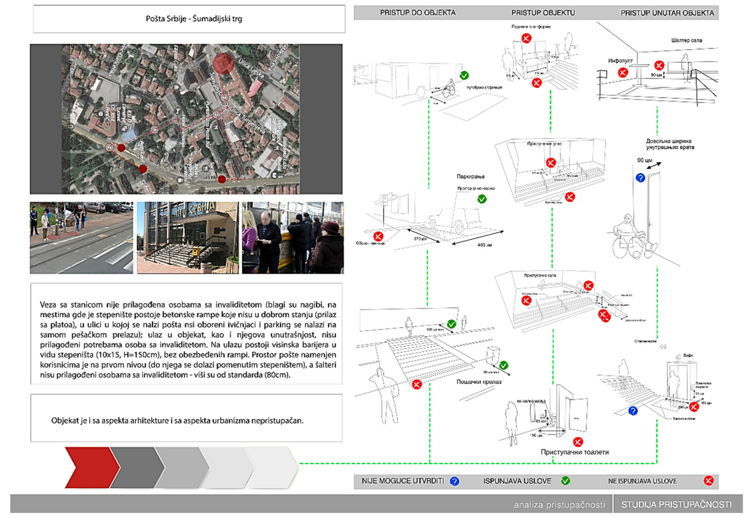
The next step consisted of two parts: (1) the visualization of the Manual on Technical Standards of Design and Construction for the People with Disabilities [19] and (2) the setting of the analytical framework for data structuring based on the Manual of Concepts on Land Cover and Land Use Information System [20] (Table 2). The visualization made for the ICT interface (Figure 2) has three segments related to three main groups of checkpoints describing the following elements: (1) access to buildings/facilities, (2) access to building entrances, and (3) the effective use of interior space. They could be marked as satisfactory, unsatisfactory or impossible to determine. Accessibility is primarily related to frequently used facilities in neighborhoods (shops, post offices, banks, cafes, parks, pharmacies, health care centers, etc.). The location of specialized centers (shopping centers, information, etc.) is also required, as well as the position of social institutions, cultural/sports/recreational facilities due to their distance from the place of residence. In the context of Serbia, only private transportation was considered, since bus stops are not adjusted to users with disabilities. All these elements indicate that the effective identification of accessibility to facilities could be performed at both the municipality and city level [21] (Table 2).
Following these steps, the identification, mapping and the accessibility assessment of public corridors was conducted in specific (pilot) urban territories, based on the data from the Google maps platform and the established list of selected checkpoints: (1) the accessibility of open spaces (7 checkpoints: accessible car parking, pathways, pedestrian crossings, street furniture, dispensers, lighting, and bus stops); (2) the accessibility of building entrances (7 checkpoints: treads, risers, handrails, wall-side and open stair markings, tactile warning strips, signage, and ramp detail layouts); (3) the accessibility of building interiors (6 points: passenger lifts, doors, signage, wheelchair stair lifts, accessible counter halls, and accessible toilets). This phase, primarily focused on neighborhood centers (i.e., places of residence of disabled users and their routes), was implemented in 29 towns of Serbia by 140 people trained by NGO Limitless. During the process, the selected criteria were additionally assessed by 20 users with disabilities and 50 students of the Faculty of Architecture at the University of Belgrade attending theme-related elective courses and workshops (e.g., Pilot Study of the neighborhood in the Municipality of New Belgrade—Block 1). The qualitative feedback obtained from this iteration facilitated the finalization of the Limitless GIS Application and provided its user-friendly interface and structure.
The Limitless GIS application, as the main outcome of the pilot project, was created as a tool which supports citizen feedback, simultaneously contributing to the further research of the ICT-based infrastructure provisions in the participative process of Universal Urban Design. Furthermore, it is focused on providing system solutions for improving the situation in cities for other vulnerable groups (the elderly persons, parents with children, etc.). Unlike similar applications, it is directed towards two groups: (1) people with disabilities (including persons with reduced mobility) who could identify and map obstacles in urban spaces, and (2) employees in the public sector (city authorities and municipalities) in charge of the organization, implementation and supervision of standards who are able to analyze pedestrian routes and plan alternative ones but also create maps of priorities targeting pedestrian improvement and estimate investment costs. However, this initial focus on two groups of users could be re-conceptualized in further research and practice, through a communicative process between the involved stakeholders.

3. Results

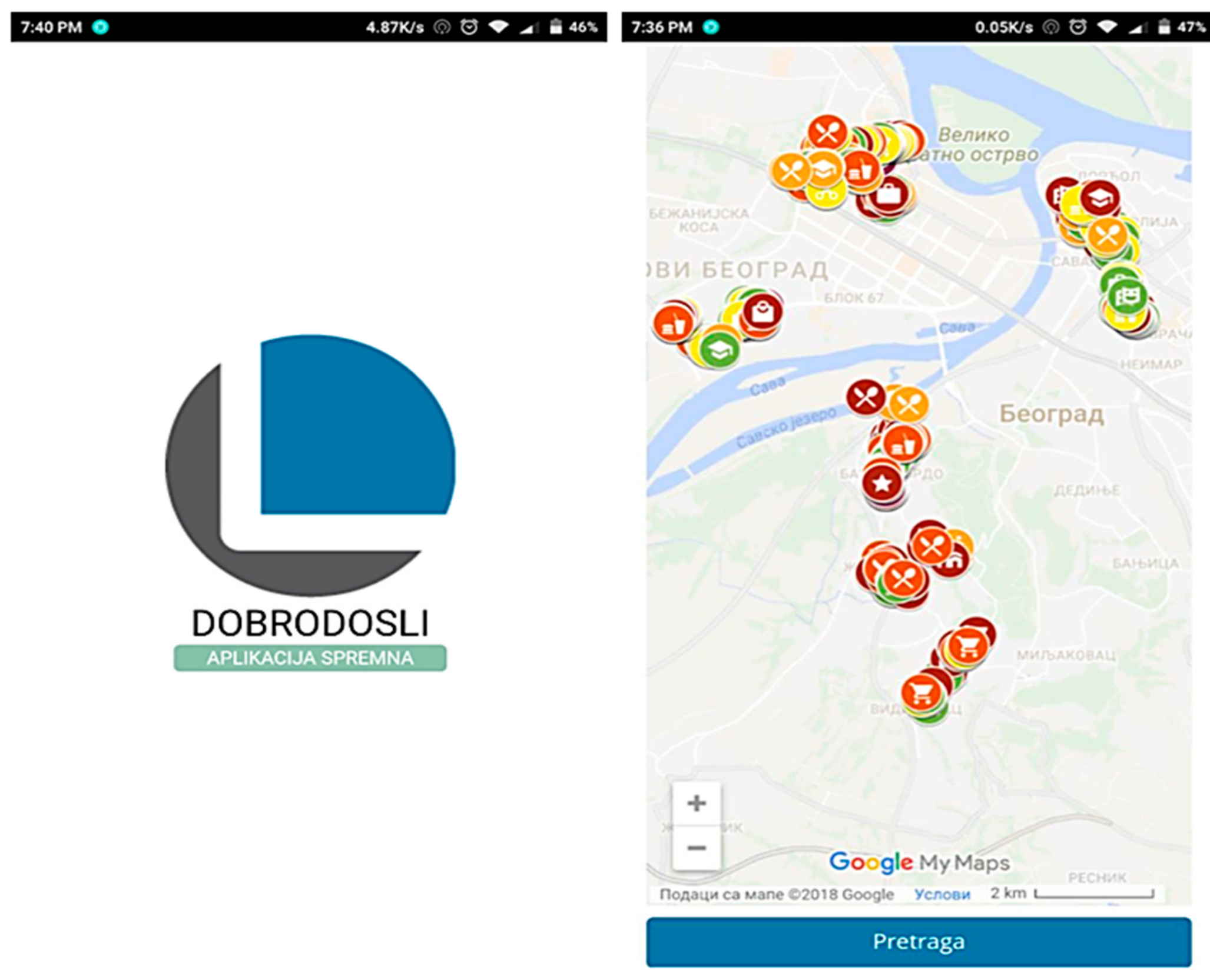
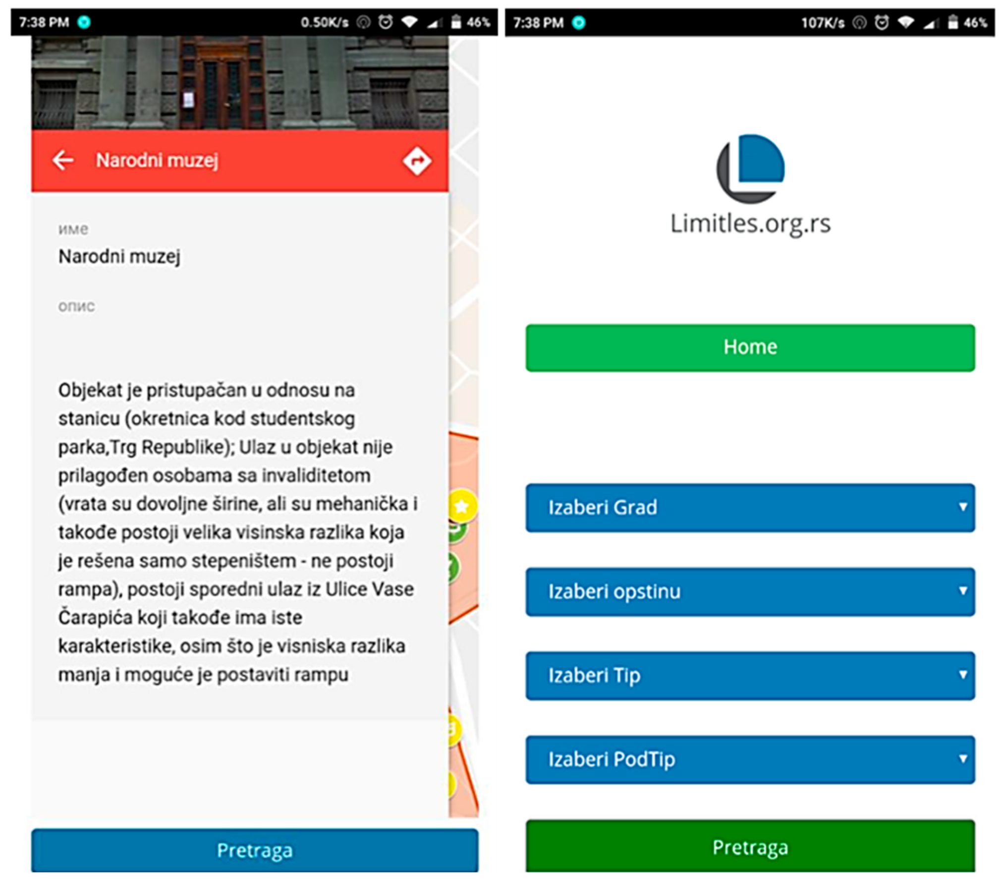
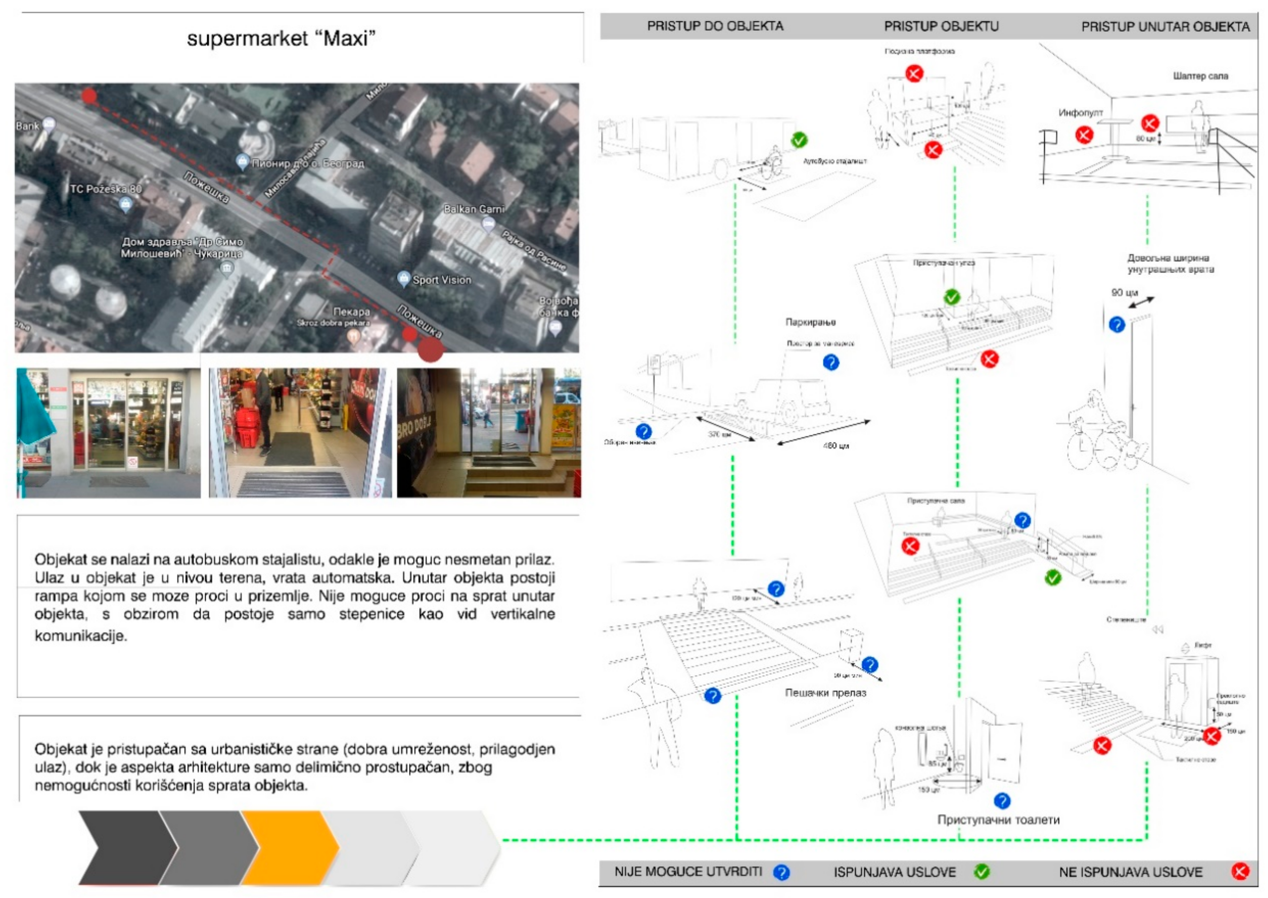
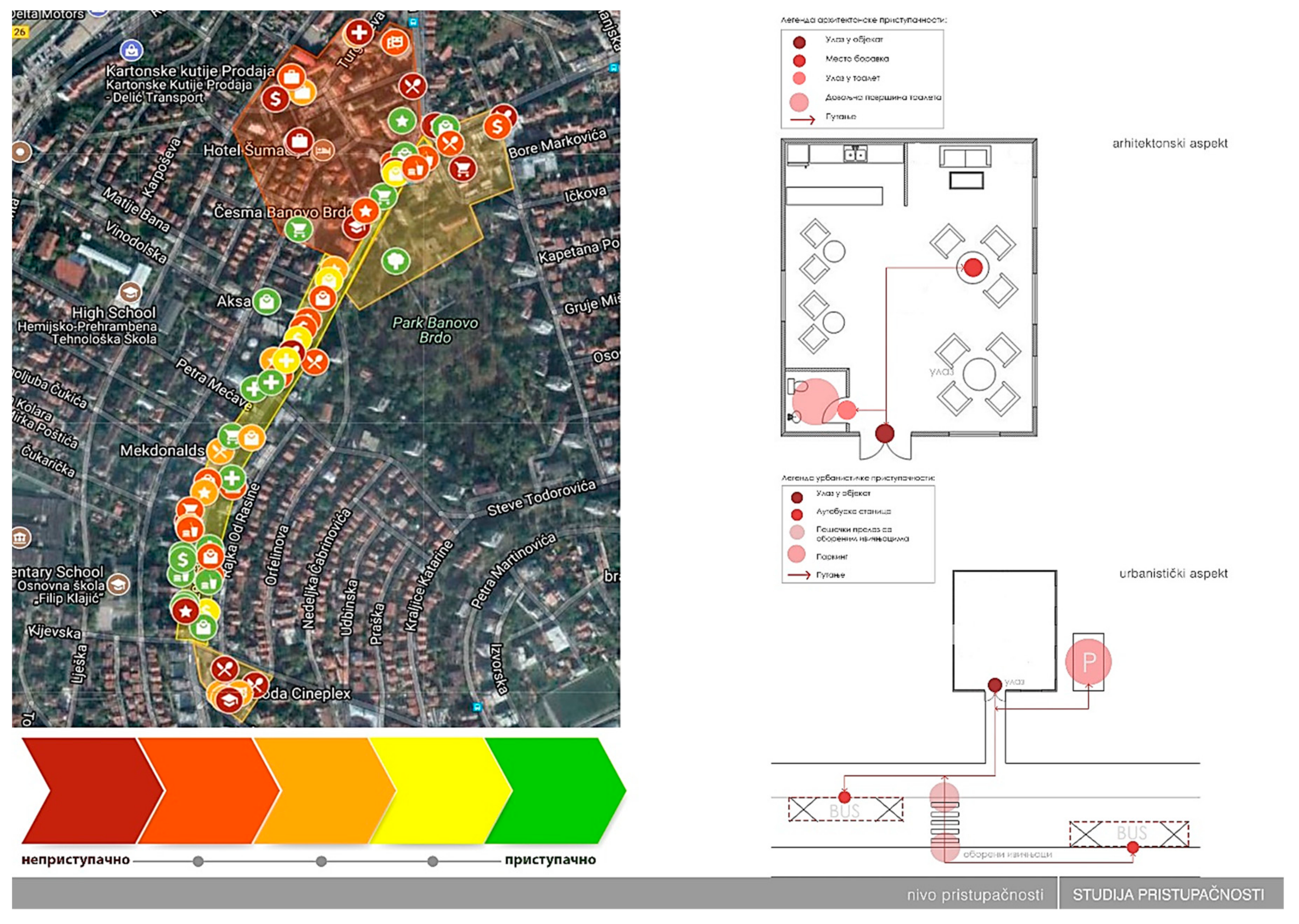
The Limitless GIS application was created by the compailer cordova android studies using js, php, html, css and SQL (Structured Query Language). The application was designed to redraw entries that are on the MySQL server, using Google Maps and API (Application Programming Interface) for displaying the entered location markers on the map [22]. The analysis of the retail outlet locations is supported by the Google maps software. In addition, vector maps are used in urban settlements. The required databases provide necessary information on demography, business demography, segments of urban infrastructure and public facilities/centers. As already mentioned, the operationalization of ICT support primarily identifies two target groups. Users with disabilities (including persons with reduced mobility) are enabled to map obstacles in urban spaces—pedestrian areas, sidewalks (Figure 3, Figure 4, and Figure 5). Following the use of the application by the first group, the second group (employees in public institutions in charge for organization, implementation and supervision of standards) was able to plan alternative routes, priorities and investment costs, based on the identified problems (Figure 6).
The Limitless GIS application and e-platform provides an input for the sustainable design which should contribute to the overall urban accessibility and ensure the full inclusion of people with limited mobility in the community. Therefore, this application could be used as a tool which enables its users to be self-dependent and self-reliant, while improving the accessibility of public spaces, transportation systems and public facilities throughout cities [23].

4. Discussion

The structure of the application/e-platform provides an insight into:
(1)
Sites of specific activities/use—e.g., hospitals, rehabilitation centers, nursing homes, schools, cultural facilities, sport facilities, banks, business buildings, hotels, hostels, restaurants, traffic terminals, open public spaces, etc. Each site is described by photos and necessary information (according to EUROSTAT Manual of Land Use);
(2)
Criteria on the accessibility distinguished through Universal Urban Design (illustrating and summarizing the most important information from the Manual on Technical Standards of Design and Construction for the People with Disabilities);
(3)
Recommendations for mapping the information related to the selected polygon of the pilot study (suggested routes, investment costs, etc.);
(4)
Brief analysis of the latest technological solutions that could contribute to better accessibility (materials, barriers, elevators, lifts, etc.).

4.1. Mapping and Evaluation

Based on the main premise of the user-centered design where accessibility primarily relates to facilities in frequent use in neighborhoods [5], the application and e-platform use this set of information combined with the locations of specialized centers that are closest to the place of residence. Based on GIS, which provides a high-quality presentation of processed data and allows new processing methods to be used, this information both guides and supports spatial-based decision making. In the Limitless application, GIS does not provide a final solution to a user but represents a tool for a better and more organized analysis of information leading toward quality decisions. Due to the GIS possibility of integrating spatial and alphanumeric data, which influences considerable cost savings [24], the application and e-platform use its operability for the elements covering the mapping of spaces, activities and obstacles to mobility (i.e., location analysis), route and timetable scheduling.
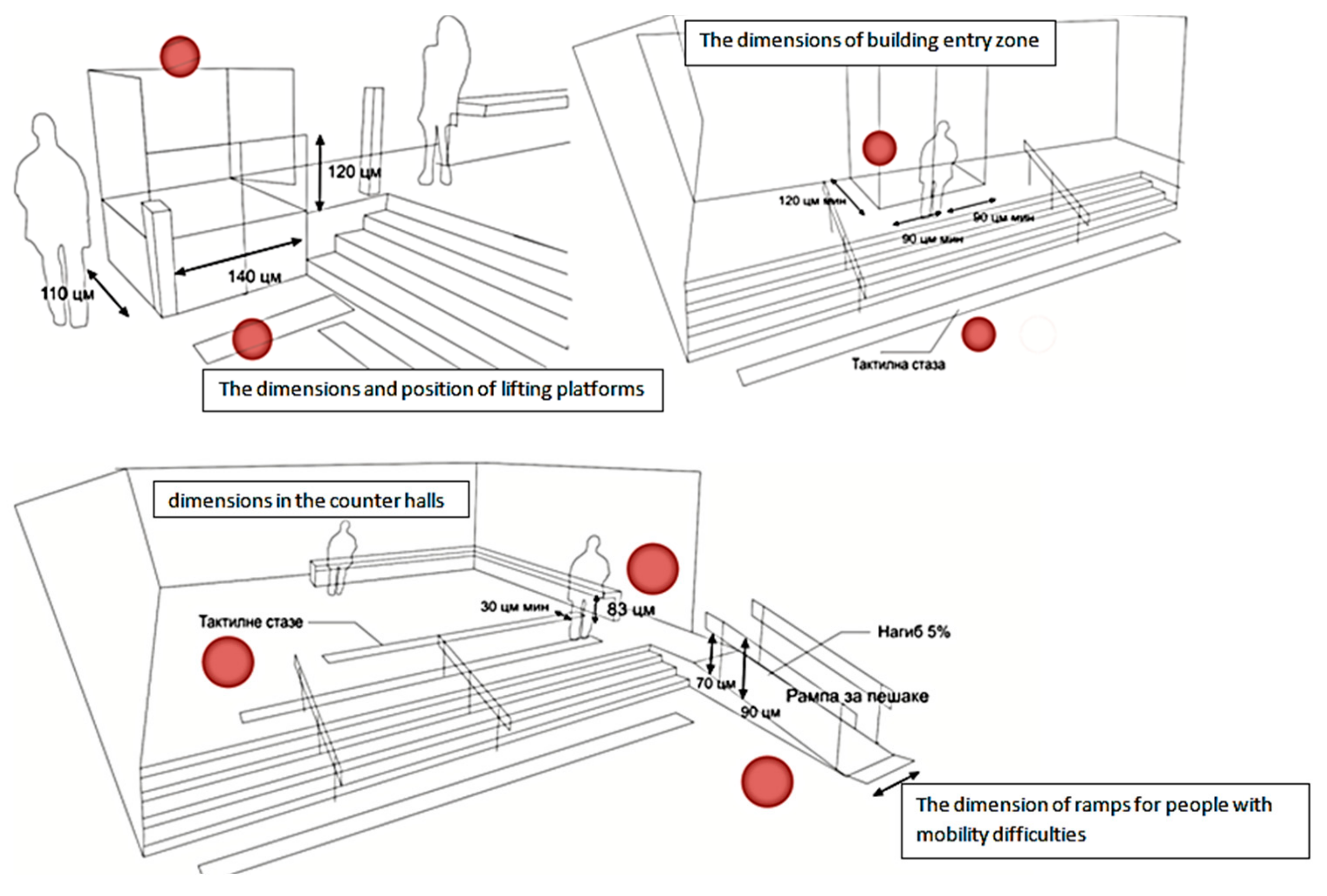
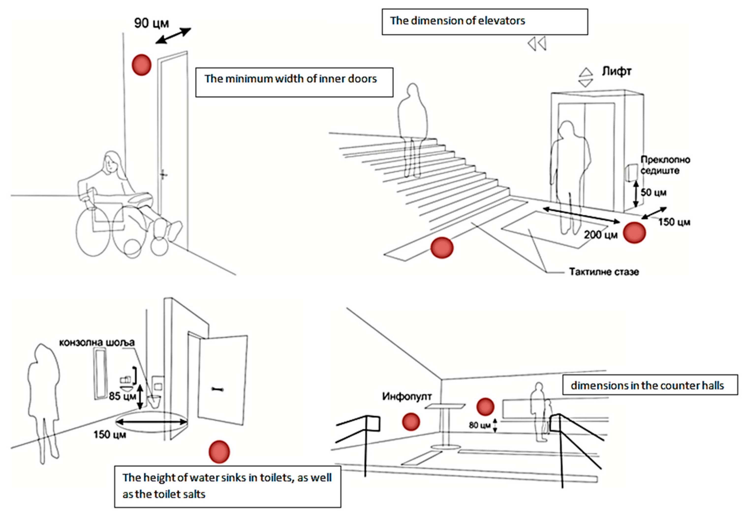
The segment of application related to the evaluation of selected spaces and activities includes illustrations of spatial elements used as criteria and checkpoints for identifying the level of accessibility. Illustrations are used in order to simplify the rules of mobility, make them more readable and understandable for users, while simultaneously enabling the evaluation of all accessibility requirements. Each illustration includes checkpoints marked by active red dots. Illustrations cover three aspects defined by specific elements of accessibility:
(1)
The accessibility of open spaces (four illustrations, seven checkpoints)—Figure 7;
(2)
The accessibility of building entrances (three illustrations, seven checkpoints)—Figure 8;
(3)
The accessibility of building interiors (four illustrations, six checkpoints)—Figure 9.
In total, 20 checkpoints may be linked to a map database. The evaluation of urban mobility of a certain location is performed using the following scale, defined after the feedback from involved users and the Serbian Alliance of Paraplegics and Quadriplegics: a) good accessibility (15–20 checkpoints); b) satisfactory accessibility (10–14 checkpoints); c) unsatisfactory accessibility (0–9 checkpoints). According to their input, at least three elements from each category (exteriors, building entrances, interiors) must be evaluated as fulfilling; otherwise, a location is marked as unsatisfactory.

4.2. Recommendations

The third section of the application is related to the guidelines facilitating the mapping and identification/selection of pedestrian routes. In a large city or county with varying levels of pedestrian demands and walkability, it is difficult to provide a high level of pedestrian amenities in all parts of the city [26], but the Limitless application may also detect areas with the highest pedestrian activity. One way to address this challenge was by grouping urban spaces into three categories of pedestrian investments, based on pedestrian demands. Areas may qualify for basic, upgraded, or premium improvements. Most streets should be targeted as basic, while in the areas with higher pedestrian demand, upgraded improvements should be implemented. They include features such as wider sidewalks, more intense lighting and landscaping and a higher quality of street crossings. These improvements are intended for commercial streets with a medium and high level of car traffic. The premium improvements should be used in the areas with the highest pedestrian demand. These improvements include the elements from the basic and upgraded group, and additional ones, contributing to the higher activity of urban place (e.g., extra-wide sidewalks, special lighting, signage, seating, etc.). The priorities of pedestrian improvement are assigned to each development project after measuring the ratio between walking potential and detected needs. GIS technology has a role in this segment of application as well, since it conducts an analysis of pedestrian demands and walkability, creating a map of priorities targeting the pedestrian improvement of selected areas.

4.3. Design and Innovation

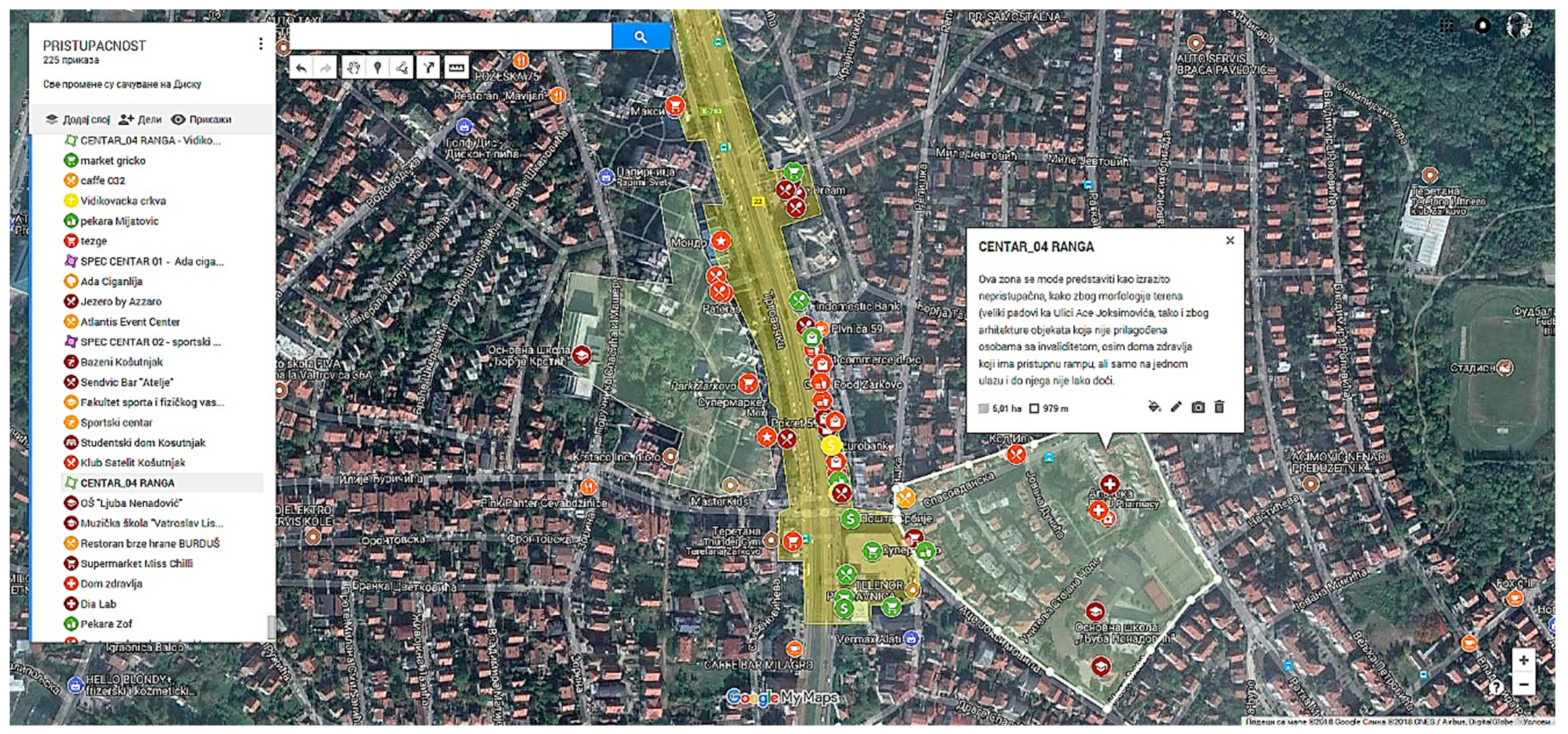
The fourth area of applicability provided by the Limitless application is intended for state/municipality authorities. It enables the identification (and recommendation) of design elements important for improving pedestrian safety and walkability. These guidelines could be used by designers, engineers, developers and other involved professionals to ensure the higher safety, accessibility and walkability of new and improved pedestrian facilities, adjusted to the latest standards and policies. The subsequent sections of the pedestrian plan define the areas, levels and dynamics of implementation (Figure 10: green—totally accessible pedestrian areas; yellow—mostly accessible; orange—accessible with difficulties; red dots—inaccessible spots/areas). This part of the application also presents guidelines from best practices. It highlights how the street design and orientation of adjoining land-use can improve safety, accessibility and comfort, while special emphasis is given to the improvement of accessibility and safety of disabled users. The first section presents design guidelines for three main components of pedestrian networks: sidewalks, street corners and crossings. The remaining sections present guidelines related to the elements contributing to the enhancement of pedestrian networks: (1) techniques used to calm traffic, (2) supportive land-uses, (3) site layout, and (4) orientation of buildings.

5. Conclusions

The pilot project “Creating Accessible Pedestrian Corridors by the Limitless GIS Application” was driven by the idea of improving the accessibility of urban spaces in Serbia, primarily focusing on users with limited mobility and disability. The findings of the study conducted in the pilot project indicate that public spaces and buildings in Serbia have low accessibility, whereas the main problem represents the lack of ramps, pavement slopes and lifting platforms, which were identified as the preferred option by the involved users and the Serbian Alliance of Paraplegics and Quadriplegics. The morphology of terrain represents another important element of accessibility, and the Limitless GIS application confirmed that the selection of preferred routes is mostly driven by these criteria (flat over hilly areas). The user feedback underlined the importance of maintaining the existing assistive technology—the instructions for using lifting platforms are often missing, the signs for blind people are damaged or unsuitably positioned, while street trees, if planted improperly, could damage sidewalks, annulling their importance in providing necessary shade, shelter and buffer zones.
Resulting in a model e-platform based on GIS technologies, the Limitless application aims to become an efficient information tool for identifying and mapping user needs and critical points/obstacles/routes. It could also be regarded as a support instrument for decision making in the management of urban development—both in the process of Participative Placemaking and in directing grants and investments. The identified users are able to enter the system through the Internet at any time, by using mobile or portable devices, while the use of mobility maps can significantly shorten the time that is necessary for certain activities which demand movement through cities. Additionally, the applied visualization of pre-defined checkpoints/spatial criteria with active fields for evaluation enables a user-friendly interface with efficient and almost immediate estimation of accessibility. Therefore, the presented information is useful for facilitating disabled people and providing an accurate picture of a selected location and its accessibility, raising the overall sustainability of urban space, as well as the public awareness of accessibility problems. The application also gathers specialized data which could be used by companies and governmental agencies responsible for the managing and planning of local facilities, with access to all. Since the easy and efficient access to specific locations should be a priority in reconstructing and making them affordable, both the horizontal and vertical coordination of all levels of management are taken into consideration. This kind of tool could also attract and involve different stakeholders, ensuring the continuous updating and maintenance of the database.
The novel combination of survey data, geographical data and qualitative data generates a model of sustainable accessibility to urban services that could be used in underdeveloped contexts and among vulnerable groups. Since equitable access to public services represents a key ingredient in increasing the well-being of disabled and sensitive groups of users, the application also contributes to the process of a self-reported data survey which is frequently the only resource of information on service accessibility in low- and middle-income countries. Realizing that there may be substantial discrepancies between perceived and actual accessibility, especially in the case of health facilities, other methods should be considered as an input which would guarantee better and more efficient health policies and planning. For example, an opportunity to map the location by several people simultaneously could result in different assessments due to personal perception caused by different levels of their motor and sensorial abilities, which would be another contribution to the database, mapping and evaluation. It is also concluded that the upcoming phases of the project require the additional training of interested users, which will be conducted in the facilities of the Serbian Alliance of Paraplegics and Quadriplegics and in daycare centers.
The methodological triangulation used in the presented pilot project and its resulting application combine the spatial analysis of perceived distances, their actual performances/level of accessibility and qualitative evidence. However, the next step in studying the level(s) of urban accessibility should be focused on the identification of causative factors for functional disability, targeting problems related to the environment, medical conditions and the distance to relevant health care services. The inclusion of the specific subgroups of users with disabilities (e.g., independent wheelchair users with different types of mobility devices), or users with mobility problems beyond the targeted disabled groups (e.g., people with baby strollers) would further increase the use of the application in urban spaces. Accordingly, all policy implications generated by the identified level of accessibility should be considered in the process of upgrading the urban environment and its sustainable features.

Author Contributions

Conceptualization, writing and editing, A.S., and V.M.; methodology and software, K.L.; resources and data curation, F.P.; editing, R.C.

Funding

The research was funded within the research project “Mapping the locations accessibility of buildings for people with disabilities” funded by the Ministry of Labor and Social Affairs, Republic of Serbia - SK 242/17 (2017-2019). Parts of the article were also conducted within the projects “Studying climate change and its influence on the environment: impacts, adaptation and mitigation” (43007) and “Spatial, Environmental, Energy and Social Aspects of Developing Settlements and Climate Change—Mutual Impacts” (36035)—both financed by the Ministry of Education and Science of the Republic of Serbia (2011–2019).

Conflicts of Interest

The authors declare no conflict of interest.

References

  1. Ostroff, E. Universal Design: An Evolving Paradigm. 2017. Available online: http://citeseerx.ist.psu.edu/viewdoc/download?doi=10.1.1.642.7529&rep=rep1&type=pdf (accessed on 6 April 2019).
  2. The Common Principles of Universal Design The City of Oslo. Available online: https://extranet.who.int/agefriendlyworld/wp-content/uploads/2015/06/The-Common-Principles-of-Universal-design-City-of-Oslo.pdf (accessed on 12 April 2019).
  3. Europе Institute for Design and Disabilities (EIDD): What is Design for All? Available online: http://dfaeurope.eu/what-is-dfa/ (accessed on 10 March 2019).
  4. Rio + 20 Declaration (“The Future We Want”, 2012). Available online: https://sustainabledevelopment.un.org/content/documents/733FutureWeWant.pdf (accessed on 10 April 2019).
  5. Sueli, S.; Mallin, V.; Gomes de Carvalho, H. Assistive Technology and User-Centered Design: Emotion as Element for Innovation. Procedia Manuf. 2015, 3, 5570–5578. [Google Scholar] [Green Version]
  6. Finn, A.; Steinar, B.; Olav, R.B.; Edel, K. Universal Design Planning and Design for All. The Norwegian State Council on Disability. 1997; p. 3. Available online: https://pdfs.semanticscholar.org/cdf1/09b81f856d5ada575d81e93992ee8e83052d.pdf?_ga=2.14692086.1726542862.1567425527-1271465808.1567425527 (accessed on 9 September 2019).
  7. Khatoun, R.; Zeadally, S. Smart Cities: Concepts, Architectures, Research Opportunities. Commun. Acm 2015, 59, 46–57. [Google Scholar] [CrossRef]
  8. Gardony, A.; Martis, S.; Taylor, H.; Brunyé, T. Interaction Strategies for Effective Augmented Reality Geo-Visualization: Insights from Spatial Cognition. Hum. Comp. Interact. 2018, 43. [Google Scholar] [CrossRef]
  9. Soares de Oliveira Neto, J.; Silva, A.; Nakano, F.; Pérez-Alcàzar, J.; Kofuji, S. When Wearable Computing Meets Smart Cities: Assistive Technology Empowering Persons with Disabilities. In Examining Developments and Applications of Wearable Devices in Modern Society; Delabrida Silva, S.A., Rabelo Oliveira, R.O., Ferreira Loureiro, A.A., Eds.; IGI Global: Hershey, PA, USA, 2018; Available online: https://www.researchgate.net/publication/319276859_When_Wearable_Computing_Meets_Smart_Cities_Assistive_Technology_Empowering_Persons_With_Disabilities (accessed on 2 September 2019).
  10. Wolbring, G.; Ball, N. Nanoscale Science and Technology and People with Disabilities in Asia: An Ability Expectation Analysis. Nanoethics 2012, 6, 127–135. [Google Scholar] [CrossRef] [PubMed] [Green Version]
  11. Dyer, M.; Corsini, F.; Certomà, C. Making urban design a public participatory goal: toward evidence-based urbanism. Proc. Inst. Civ. Eng. Urban Des. Plan. 2017, 170, 173–186. [Google Scholar] [CrossRef]
  12. Amado, M.P.; Santos, C.V.; Moura, E.B.; Silva, V.G. Public Participation in Sustainable Urban Planning. World Acad. Sci. Eng. Technol. 2009, 53, 597–603. [Google Scholar]
  13. UN. Transforming our world: The 2030 Agenda for Sustainable Development; United Nations: Geneva, Switzerland, 2015; Available online: https://sustainabledevelopment.un.org/content/documents/21252030%20Agenda%20for%20Sustainable%20Development%20web.pdf (accessed on 21 June 2019).
  14. Thomas, D. Placemaking: Urban. Design Methodology; Routledge Research in Planning and Urban Design Series; Ache, P., Ed.; Radboud University: Nijmegen, The Netherlands, 2016. [Google Scholar]
  15. Doukas, C.; Metsis, V.; Becker, E.; Le, Z.; Makedon, F.; Maglogiannis, I. Digital cities of the future: Extending @home assistive technologies for the elderly and the disabled. Telem. Inf. 2011, 28, 176–190. Available online: https://www.sciencedirect.com/science/article/pii/S073658531000050X (accessed on 10 September 2019). [CrossRef]
  16. Republic Bureau of Statistics. People with Disabilities in Serbia. 2011. Available online: pod2.stat.gov.rs/ObjavljenePublikacije/Popis2011/Invaliditet.pdf (accessed on 9 July 2019).
  17. Ministry of Social Affairs, Republic of Serbia. Strategy for advancement of position for people with disabilities 2020. 2018. Available online: https://www.minrzs.gov.rs/sites/default/files/aktuelno/doc/2016_godina/Javne_rasprave/Polozaj_invalida/RV_AP_NOVI.doc (accessed on 9 July 2019).
  18. UN. Accessibility and Development, Mainstreaming disability in the post-2015 development agenda; Department of Economic and Social Affairs, Division for Social Policy and Development: Geneva, Switzerland, 2013. Available online: https://www.un.org/development/desa/dspd/2013/12/24/accessibility-and-development-mainstreaming-disability-in-the-post-2015-development-agenda/ (accessed on 11 September 2019).
  19. Ministry of Construction, Transport and Infrastructure-MCTI. Manual on Technical Standards of Design and Construction for the People with Disabilities; Ministry of Construction, Transport and Infrastructure-MCTI: Belgrade, Serbia, 2015. Available online: https://www.paragraf.rs/propisi/pravilnik_o_tehnickim_standardima_planiranja_projektovanja_i_izgradnje_objekata_kojima_se_osigurava_nesmetano_kretanje_i_pristup_osobama_sa_invaliditetom_deci_i_starim_osobama.html (accessed on 18 June 2019).
  20. EUROSTAT Manual of Concept on Land Cover and Land Use Information System. 2002. Available online: https://ec.europa.eu/eurostat/ramon/statmanuals/files/KS-34-00-407-__-I-EN.pdf (accessed on 2 August 2019).
  21. ESPON 2013: European Land Use Patterns. Available online: https://www.espon.eu/land-use-2012 (accessed on 3 September 2019).
  22. Srdjan Vejnovic, programmer for the Limitless application and e- platform. Available online: https://mape2018.advokatmisic.com/produkcija_front/home/strana_naslovna.html (accessed on 11 December 2018).
  23. Zainol, H.; Isa, H.M.; Sakip, R.; Azmi, A. Social Sustainable Accessibility for People with Disabilities at Public Transport Stations through Sustainable Development Goals in Malaysia. 2018. Available online: https://www.researchgate.net/publication/329157490_Social_Sustainable_Accessibility_for_People_with_Disabilities_at_Public_Transport_Stations_through_Sustainable_Development_Goals_in_Malaysia (accessed on 12 August 2019).
  24. Dale, P.F.; McLaren, R.A. GIS in Land Administration. University of Edinburgh. 2005. Available online: https://www.geos.ed.ac.uk/~gisteac/gis_book_abridged/files/ch61.pdf (accessed on 13 August 2019).
  25. Lalović, K.; Kažić, I.; Mihajlov, V.; Drljača, M.; Petrovic, F. Pilot studija operativnih mogućnosti unapredjenja pristupačnosti fizičkog okruženja u Srbiji (Pilot-study of Operational Possibilities for the Advancement of Accessibility in Urban Environment in Serbia); LIMITLESS: Belgrade, Serbia, 2018; ISBN 978-86-900483-0-4. [Google Scholar]
  26. Sacramento Transportation Collaborative. Best Practices for Pedestrian Master Planning and Facility Design. 2005. Available online: https://nacto.org/docs/usdg/best_practices_ped_master_planning_design_sacramento.pdf (accessed on 14 July 2019).
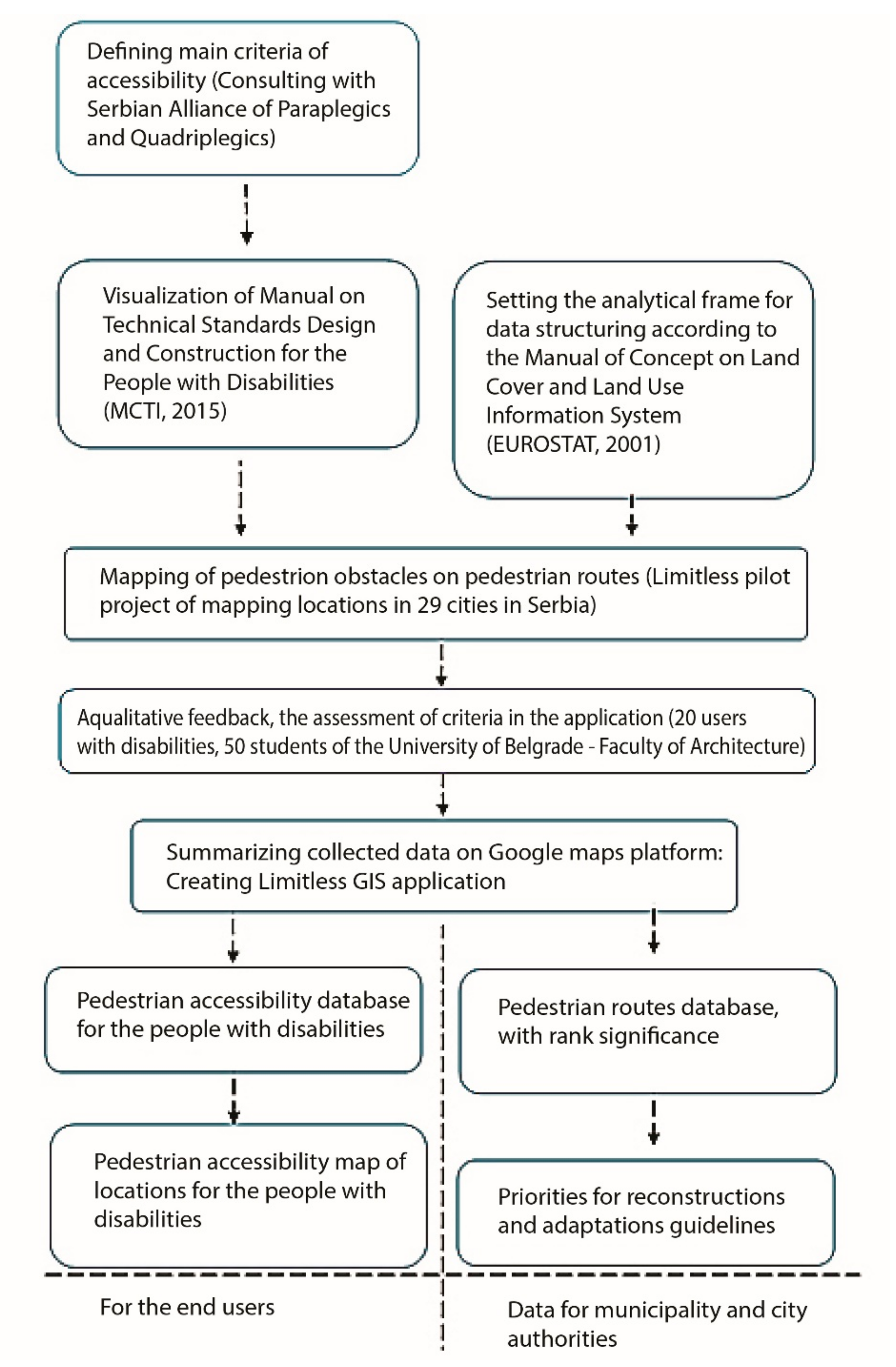
Figure 1. The diagram of planned activities and expected effects in the process of creating the Limitless Geographic Information System (GIS) application and e-platform.
Sustainability 11 05459 g001
Figure 2. The visualization of the Manual on Technical Standards of Design and Construction for the People with Disabilities [19] as a medium for the identification and technical assessment of obstacles in the pedestrian areas of cities. Left: the description of the location accessibility with final assessment (accessible/inaccessible). Right: the visualization of three main groups of checkpoints related to (1) access to buildings/facilities, (2) access to building entrances, (3) the effective use of interior space, where each could be marked as satisfactory, unsatisfactory or impossible to determine. Source: https://limitless.org.rs/map/.
Sustainability 11 05459 g002
Figure 3. The Limitless GIS application. Left: the intro page. Right: mapping the obstacles in pedestrian areas of the Belgrade city center—via the Google Maps application. Source: https://limitless.org.rs/map/.
Sustainability 11 05459 g003
Figure 4. The presentation of results related to the selected markers on the map. Left: The description of the accessibility of a selected location. Right: The Search menu with criteria (city /29 cities included, municipality and the type/subtype of use according to the EUROSTAT analytical framework for data structuring based on the Manual of Land Use [20]). Source: https://limitless.org.rs/map/.
Sustainability 11 05459 g004
Figure 5. The interface of a submitted application form, including information on accessibility. Left: the description with a final assessment (accessible/inaccessible). Right: the visualization of three main groups of checkpoints related to (1) access to buildings/facilities, (2) access to building entrances, (3) the effective use of interior space, with each marked as satisfactory, unsatisfactory or impossible to determine (according to the Manual on Technical Standards of Design and Construction for the People with Disabilities [19]). Source: https://limitless.org.rs/map/.
Sustainability 11 05459 g005
Figure 6. The interface of a submitted application form providing information on the accessibility of possible routes which could be used by the institutions responsible for the implementation and supervision of standards. Left: The accessibility levels of a route (the scale was defined after feedback from the users and the Serbian Alliance of Paraplegics and Quadriplegics). Right: The visualization of the selected spot—architectural and urban accessibility. Source: https://limitless.org.rs/map/.
Sustainability 11 05459 g006
Figure 7. Reading the accessibility of urban exterior space (four illustrations with main checkpoints: the dimensions of wheelchair space at bus stops, the dimensions necessary for wheelchairs maneuvering at a parking space, the dimensions and shape of pedestrian crossings, and the positioning of sidewalks and information boards). Source: [25].
Sustainability 11 05459 g007
Figure 8. Reading the accessibility of building entrances (four illustrations with main checkpoints: the dimension and position of lifting platforms, the dimensions of building entry zone, the dimension of ramps for people with mobility difficulties, and the dimensions in counter halls). Source: [25].
Sustainability 11 05459 g008
Figure 9. Reading the accessibility of interior space (four illustrations with main checkpoint criteria: the dimension of inner doors, the positions of door handles, the dimension of elevators, the height of water sinks in toilets, as well as the toilet seats). Source: [25].
Sustainability 11 05459 g009
Figure 10. Mapping the elements that define the ranking of pedestrian routes and areas, as well as the implementation of recommendations: the case of Banovo Brdo, Belgrade. Left: Menu providing information on the levels of building accessibility along the selected pedestrian route. Right: The description of accessibility features at a selected spot. Source: https://limitless.org.rs/map/.
Sustainability 11 05459 g010
Table 1. The list of accessibility criteria defined in cooperation with the Serbian Alliance of Paraplegics and Quadriplegics.
CriteriaStandards/Indicators
Accessibility of open spaces
Bus stops: the dimensions of space for wheelchairs90 × 90 cm (min)
Parking: the dimensions for maneuvering370 × 480 cm (min)
Crossing slopesTransverse slope 2%, Longitudinal slope 5%
Pavement width150 cm (min)
Facing joint space for wheelchair5 mm (max)
Pavement height3 cm (min), 15 cm (max)
Surface color of guide trackContrast of pavement color
Accessibility of building entrances
Entrance lifting platform120 × 150 cm (min)
Accessible ramp slope 5% (max)
The dimensions of building entry zone180 cm width × 120 cm depth (min)
The surface color of guide trackContrast of pavement color
The height on the counter halls83 cm (max)
The width of guide trackContinuous, 30 cm (min)
The distance between entrance door and ramp120 cm (min), 200 cm (max)
Accessibility of building interiors
The dimensions of elevators200 × 150 cm (min)
The width of inner doors90 cm (min)
The width of guide trackContinuous, 30 cm (min)
The height of water sinks in toilets83 cm (max)
The height of toilet seats40 cm (max)
The toilets: the dimensions for maneuvering150 cm diameter (min)
The position and color of info deskContrast of pavement color, 83 cm height (max)
Table 2. Analytical framework for data structuring—the accessibility of public buildings (according to ESPON (European Spatial Planning Observation Network), 2013 [21] and EUROSTAT (European Statistical Office), 2001 [20], adopted for the Limitless e-platform).
Classification of Activities in the City CenterAccording to the Methodology from ESPON, 2013According to the Manual of Land Use (EUROSTAT, 2001)
Social standard facilities
Public and private sector
Health care servicesHospitals, daily health care centers, rehabilitation centers, specialist ordinations, labs, and pharmaciesHospitals, daily health care centers, and rehabilitation centers
Social welfare centersHomes for the elderly, social welfare centers, pension funds, and Non-Governmental Organization (NGO) officesHomes for elderly persons
Education and sciencePrimary schools, secondary schools, faculties, institutes, educational centers, and student dormsSchools and similar objects
Culture and artTheatres, cinemas, galleries, cultural centers, and fairsCultural facilities
Sport and recreationSport centers and recreational centersSport and recreational facilities
Business and services facilities
Private sector
Business buildingsBanks, post offices, agencies, and representative officesBanks, post offices, business buildings, hotels, hostels, and restaurants
HotelsRestaurants and cafes, fast food facilities, hostels, hotels, private accommodation
Economy and production facilitiesCraft shops (personal services, household maintenance) and production facilities
TradingShops and specialized shops, markets, and shopping malls
Transport facilities
Public and private sector
Traffic terminalsBus terminals, railway stations, marinas, bus and tram stops, public garages, and parkingTraffic terminals and facilities
Management and protection services
Public sector
AdministrationFacilities for the needs of state authority bodies and municipalitiesFacilities for the needs of state authority bodies and municipalities
Public authority institutionCourts, associations, agencies, and customs
Police and army inst.Police, etc.
Public spaces
Public sector
In urban tissueStreets, squares, and parksPublic spaces
Open recreational spacesCity forests, city coasts, sport terrains, etc.