Article

Spatial Characterization of Seawater Intrusion in a Coastal Aquifer of Northeast Liaodong Bay, China

1
School of Earth Sciences and Engineering, Hohai University, No. 8 Focheng West Road, Nanjing 211100, China
2
Groundwater Research Center, Nanjing Hydraulic Research Institute, Nanjing 210029, China
*
Author to whom correspondence should be addressed.
Sustainability 2019, 11(24), 7013; https://doi.org/10.3390/su11247013
Submission received: 21 October 2019 / Revised: 29 November 2019 / Accepted: 3 December 2019 / Published: 9 December 2019
(This article belongs to the Section Environmental Sustainability and Applications)

Abstract

:
The safety of groundwater resources in coastal areas is related to the sustainable development of the national economy and society. Seawater intrusion is a serious problem threatening the groundwater environment in coastal areas. Climate change, tidal effects and groundwater exploitation may destroy the balance between salt water and fresh water in coastal aquifers, leading to seawater intrusion. The threat of seawater intrusion has attracted close attention, especially in the coastal areas of northern China, and the accuracy and efficiency of seawater intrusion monitoring need to be improved. The aim of this study was to fill the blanks in seawater intrusion research in the coastal aquifer of the Daqing River Catchment, northeastern Liaodong Bay, China, and determine the extent and evolutionary characteristics of seawater intrusion in this area. In this study, historical chloride concentration data were used to trace the evolution of the salinization, and electrical resistivity tomography (ERT) was used to supplement the data in areas with limited hydrochemical data and to detect the saltwater/freshwater interface, especially in the area near the Xihai Sluice. The results show that seawater intrusion in the Daqing River Catchment is mainly caused by overexploitation of groundwater. Since 2012, strict controls have been placed on the groundwater exploitation rate, and the chloride concentration of 250 mg/L has receded year by year, with saltwater being significantly reduced by 2018. The Daqing River plays an important role in the saltwater distribution. The Xihai Sluice, located in the lower reaches of the Daqing River, intercepts and controls the seawater intrusion in a certain range by raising the level of fresh groundwater to intercept and control saltwater intrusion within a certain range. The research results also confirmed that a combination of geophysical and geochemical methods is of great value in studying seawater intrusion, especially in areas with limited available hydrochemical data. A monitoring network with ERT instruments and wells should be established to collect regular measurements of the electrical resistivity distribution, as well as the groundwater level and chemical composition.

1. Introduction

The exploitation of groundwater in coastal aquifers has expanded since surface water has gradually become unable to meet the growing needs for freshwater due to developing technology and an increasing population. With the background of global climate change, seawater intrusion is a coastal geological disaster caused by human activities, especially groundwater overexploitation, which leads to many environmental problems. In general, seawater intrusion refers to the phenomenon by which the balance between saltwater and freshwater is destroyed by natural geological processes or human activities (e.g., climate change and sea level fluctuations) [1,2,3,4,5], groundwater recharge [6,7], and overextraction of groundwater [5,8,9], in which the saltwater spreads inland and causes the fresh groundwater to become salty. Seawater intrusion results in a series of environmental problems, such as excessive salinity of groundwater, deterioration of drinking water quality, soil salinization, and death of vegetation [10,11,12]. Seawater intrusion happens in dozens of countries and coastal areas, including Italy, Greece, Australia and China, and all these countries have carried out extensive research on seawater intrusion [13,14,15]. For example, Mastrocicco et al. [13] employed a three-dimensional SEAWAT model to simulate the seawater intrusion into the coastal aquifers of Variconi Oasis (Italy) under the conditions of climate and landscape changes. Kazakis et al. [14] improved the GALDIT-SUSI method for seawater intrusion assessment, and applied it in predicting the seawater intrusion in Greece and Italy, with good results. Bryan et al. [15] used the hydrochemical method and isotope method to analyze the influence of freshwater lens on seawater intrusion in the dry season. The Chinese coastline is 18,000 km long, and many coastal regions are centers of economic development in China [16]. In the coastal regions of China, excessive development and improper management have led to serious groundwater resource security issues in the north, promoting seawater intrusion [12]. In the 1960s, seawater intrusion was discovered in Dalian City, China, and in the late 1970s, seawater intrusion was successively found in other provinces. At present, Hebei, Jiangsu, Zhejiang, Shanghai, Guangxi, Liaoning, Tianjin, Shandong, Hainan and nine other coastal provinces have experienced different degrees of seawater intrusion, the most serious of which have occurred in Shandong Province and Liaoning Province. However, there has rarely been research on the seawater intrusion in Liaodong Bay of Liaoning Province. Furthermore, seawater intrusion research in Yingkou City is blank, and the gap needs to be filled.
In nature, the hydraulic gradient in a coastal aquifer points to the ocean, and freshwater flows from the land to the ocean. Generally, seawater and freshwater remain balanced with a dynamic interface, and seawater and freshwater are miscible, thus many researches focused on this mixing zones and the dispersive problem [17,18]. For example, Abarca et al. [17] modified Henry’s problem to ensure sensitivity to density variations and vertical salinity profiles that resemble field observations. Fashs et al. [18] developed a new semianalytical solution for the velocity-dependent dispersion Henry problem using the Fourier–Galerkin method (FG). The thicknesses of the observed mixing zones vary widely among laboratory experiments, field tests, and numerical simulations [11,19,20,21,22]. Goswami and Clement [20] performed three types of laboratory-scale experiments to study the transport patterns of a saltwater wedge in a freshwater aquifer. In addition, Abarca et al. [21] proposed a colorimetric experimental method to map the mixing zone of a saltwater wedge. These laboratory experiments demonstrated narrow mixing zones in homogeneous porous media [11]. Jakovovic et al. [23] used a numerical modeling method to extend the laboratory sand-tank experiments of saltwater upconing. The mixing zones in the field tests are considerably large and can range from a few meters to kilometers [11,19,24,25]. The most effective way to analyze the seawater intrusion process and detect the seawater/freshwater interface is to carry out real-time monitoring of an aquifer. However, this type of real-time monitoring needs not only a long period of data accumulation but also considerable manpower and material resources. Many areas with seawater intrusion problems lack long time series and effective real-time monitoring data; therefore, geochemical and geophysical methods have played an important role in the measurement of coastal aquifers in the current decade [6,10,22,25,26,27,28,29,30]. Geochemical methods are also of great value in the study of the evolution of seawater intrusion. For example, N. Boluda-Botella et al. [31] used Br/Cl ratios to discern the influence on hydrogeochemical transport in a coastal aquifer in Morocco and aimed to provide experimental data on how water composition changes during simulated seawater intrusion. Giménez-Forcada [32] applied the hydrochemical facies evolution diagram (HFE-Diagram) combined with quantitative results of spatial changes in a geographic information system (GIS) map to study the freshwater/seawater interface and determine the intrusion status of seawater in Vinaroz, Spain. The range of the mixing zone can also be detected with hydrochemical methods. When Price et al. [24] studied the groundwater flow in a surficial aquifer system (SAS) beneath Everglades National Park (ENP) in southern Florida, they found a wide (6–28 km) seawater mixing zone through groundwater salinity measurements. Furthermore, with the occurrence and development of seawater intrusion, migration, adsorption, and aggregation of the chemical ions in groundwater occur with a certain regularity. The characteristic values of several ions can be selected to form an index system, which can be used to monitor seawater intrusion. Chloride is the stable ion in seawater, and the chloride concentration the most commonly used indicator in monitoring seawater intrusion.
Geophysical methods are also widely used in monitoring saltwater/freshwater interfaces, based on the difference in apparent resistivity between saltwater and freshwater. Resistivity is sensitive to changes in groundwater saturation and pore water salinity, making it suitable for monitoring seawater intrusion [27,33,34]. Electrical resistivity tomography (ERT) has been widely used in the saline zones of aquifers with vertical two-dimensional (2D) images [35,36,37], and this method can illustrate the freshwater/seawater interface [38]. For example, the electrical resistivity tomography (ERT) method was applied by Morrow et al. [39] to study seawater intrusion in coastal aquifers of Kapiti Coast, New Zealand. Ebraheem et al. [40] used hydrogeological and geoelectrical methods, including ERT, to assess the groundwater resources in Wadi Al Bih, UAE. In addition, Kim et al. [41] presented a simple method to estimate the depth of the freshwater/seawater interface in coastal aquifers using two sets of pressure data obtained from the fresh and saline zones within a single borehole. Zarroca et al. [42] used the electrical methods of vertical electrical sounding (VES) and ERT to map and monitor the freshwater/seawater interface in Alt Emporda, northern Spain. Kazakis et al. [6] used hydrochemical data and ERT to map seawater intrusion in the coastal area of the eastern Thermaikos Gulf, Greece. Further, Goebel et al. [43] presented research on the use of resistivity imaging to reveal complex patterns of saltwater intrusion along 40 km of the Monterey Bay coast in central California.
The previous studies have shown that geochemical methods have a wide sampling range, and abundant results from the samples can be obtained. However, the results are scattered and only reflect the information of observation points. Thus, the spatial distribution position, depth, and shape of the seawater/freshwater interface are difficult to directly detect in the field. ERT enables visualization of the subsurface resistivity distribution in two or three dimensions [11], and can obtain section data, which provide a rapid test in the field and no impact of the ground surface. The ERT method cannot provide accurate ion values to characterize the pollution degree directly; thus, it is usually used as a qualitative analysis method in practical applications. Thus, seawater intrusion monitoring requires a multidisciplinary approach to improve accuracy. Furthermore, there are few research papers on using the combined method of geochemistry and geophysics to monitor seawater intrusion in the river basin area lacking previous studies, especially in the area near estuary of river basin with a river sluice nearby.
In this study, hydrochemical and geophysical methods were combined to describe the seawater intrusion before and after the reduction of groundwater exploitation in the coastal area of Daqing River Catchment, China. Historical geochemical data were applied to define the extent of the seawater intrusion process, including its evolution and geometry. ERT was used to study the interface of seawater intrusion and verify the results related to chloride ions, focusing on the interface at the Xihai Sluice. In addition, the ERT results were re-measured at two sites following the dry season and rainy season to record the potential evolution of the saline zones in the coastal aquifer. The results of hydrochemistry based on chloride ion analysis were compared with those of geophysics based on ERT. This comprehensive research was conducted to: (a) establish the relationship between the pumping regime, climate conditions, and seawater intrusion; (b) clarify the regional scope of seawater intrusion and the law of development of the seawater/freshwater interface; and (c) plan management activities, such as water resource regulation, in the coastal areas, and to put forward targeted solutions while making full use of the characteristics of the area.

1.1. Study Area

The study area is located in a coastal aquifer in Yingkou, northeastern Bohai Bay, China (Figure 1). The Yingkou coast lies in the eastern part of Liaodong Bay in Northeast China. The geographical coordinates are east longitude 121°56′ to 123°02′ and north latitude 39°55′ to 40°56′. Yingkou City lies in Liaoning Province, with an area of 4970 km2, a coastline of 96 km, and a population of 2.30 million, facing Liaodong Bay near Jinzhou City and Hulu Island [44]. Yingkou City is an important sea passage in Northeast Asia.
The climate of the study area is mild, with an average temperature between 9 °C and 10 °C. The frost-free period lasts from 180 to 210 days. The rainy season is from July to early September, and the dry season is from December to the following March. From 2000 to 2016, the annual precipitation was between 600 and 800 mm, and the annual evaporation was 1000–1200 mm (Figure 2). In 2016, the value of annual evaporation is greater than that of annual precipitation. The amount of surface water resources in Yingkou is 680.2 million m3, and the amount of groundwater resources is 235.7 million m3. The Daqing River system originates from Dongdaling, running through 20 towns in Yingkou and then into Liaodong Bay. In the Daqing River Catchment, the terrain is high in the east and low in the west, with an area of approximately 1482 km2, and the main river is approximately 100.7 km long. To regulate the runoff volume of the river, which changes with the seasons, the Shimen Reservoir was built upstream, and the Xihai Sluice, was built downstream. The Wangbaoshan Hydrological Station is located in the lower reaches of the Shimen Reservoir. Both sides of the riverbank are mountainous, with the watershed as the boundary of the two sides.
The study area starts from the Wangbaoshan Hydrological Station in the middle reaches of the Daqing River and ends at the mouth of the Daqing River, with four water source areas near the river (Figure 1). The Tuandian water source area, located near the Wangbaoshan Hydrological Station, contains 19 wells, with the original exploitation amount being 30,000 m3/d. A management plan involving a reduction in groundwater pumping in the water source areas has been carried out since 2012. The groundwater exploitation amount was reduced in the latter half of 2013, to 7000 m3/d in the Tuandian water source area (Figure 3). The Yinzhuhuafang water source area, located on the left bank of the Daqing River Catchment, consists of eight wells. The original exploitation amount was 15,000 m3/d, and the exploitation amount is currently 5000 m3/d. There are 11 wells in the Gaizhou water source area, located on the left bank of the Daqing River. The original exploitation amount was 30,000 m3/d, and the present exploitation amount has been reduced to 12,000 m3/d. The Yongan water source originally had 21 wells, but 19 wells have been preserved. The original exploitation amount was 50,000 m3/d, and the present exploitation amount is 15,000 m3/d. The Xihai Sluice is located in the Xihai Village. At high tide, the water level can rise to the front of the Xihai Sluice, and the fluctuation difference is approximately 3 m. This sluice is mainly used to regulate runoff storage and to bring water to the Xihai irrigation area which stretches across 12,000 acres.

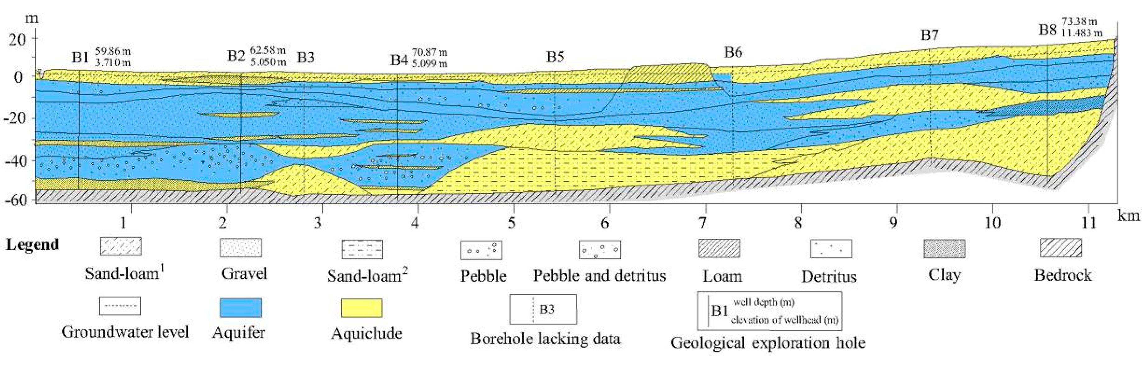
1.2. Geological and Hydrogeological Setting

Yingkou Bay is a silt-muddy plain with strong corrosion at the coast [45]. There are branched, claw-shaped valley terraces spread between low hills and scattered alluvial fans in front of the mounds. The low hill areas are mainly distributed in northeastern, central and southwestern Yingkou. Marine abrasion topography is distributed sporadically in the low hill in front of the western coastal zone. The surface is slightly tilted towards the sea, and the terrace surface is approximately 50–200 m wide.
The study area is a plain area formed by the alluvium and the diluvium of the Daqing River. The plain aquifer formed by the river alluvium varies greatly because the river flow changes with the season and climate. In the study area, the aquifer mainly includes shallow phreatic pore water in loose rock. The distribution is stable, and the thickness is large, which is best for aquifer formation. A large number of boreholes are used for the abstraction of groundwater from porous aquifers to meet the water demands for agricultural, tourism, domestic, and industrial use. Figure 4 is the geological profile of the I–I’ cross section in Figure 1. The aquifer can be divided into three layers. The first layer is the quaternary overburden, dominated by loam and clay. The aquifer type is a phreatic aquifer with a thickness ranging from 2 m to 10 m. The second layer mainly consists of sandy gravel, partly deposited loam, sandy loam, and so forth. In general, it is a confined aquifer and partly phreatic aquifer. The third layer mainly consists of sandy loam and clay and is a confined aquifer.
In general, in the middle and lower reaches of the Daqing River, the aquifer has a single-well yield of more than 5000 m3/d, and it is mainly composed of alluvial deposits and diluvial deposits. From upstream to downstream, the particle size distribution substantially changes. The hydraulic conductivity of the aquifer ranges from 50 m/d to 150 m/d. The hydrochemical type of the groundwater is HCO3-Ca (Na) in the upstream, HCO3-Cl-Ca (Na) in the downstream, and Cl-HCO3-Ca-Na (Na) near the river. The groundwater salinity is less than 0.3 g/L and up to 0.4–0.7 g/L near the estuary.

2. Materials and Methods

2.1. Collection and Analysis of the Hydrochemical Data

The chloride concentration is the most commonly used seawater intrusion monitoring index, and its value is determined according to the allowable or tolerable value of drinking water and the standard of agricultural irrigation water. A high chloride concentration in drinking water will produce an extremely unpleasant taste and cause corrosion in the water distribution system. It is proposed that the concentration of chloride in irrigation water should not exceed 200 mg/L under continuous irrigation and should not exceed 200–300 mg/L under intermittent irrigation in China. At the same time, the chloride concentrations should not exceed 250 mg/L based on the Environmental Quality Standards for Surface Water (GB3838-2002) and the Standard for Groundwater Quality (GB/T 14848-2017).
Historical data of chloride concentrations were obtained from the monitoring network of the Hydrological Bureau of Yingkou City, which was initiated in 2004. When the survey of chloride ion concentration was first carried out, a few sampling points were located in the Daqing River Catchment. Due to the importance of the seawater intrusion problem, the number of sampling points gradually increased. However, due to the limitation of sampling conditions, the location and number of sampling points used were different each year. In order to study the evolution of seawater intrusion before and after the reduction of groundwater exploitation in 2012, chloride concentration data of the study area in key years were selected for analysis. There were 31 sampling points in 2011, and after three years of reduction of groundwater pumping amount in the water source areas, there were 34 sampling points in 2014, 34 sampling points in 2015, 37 sampling points in 2016, 26 sampling points in 2017, and 37 sampling points in 2018 (Appendix A, Table A1). The groundwater sampling layer is consistent with the monitoring target layer, the sampling wells are civil wells, and production wells are used all year round. The inner diameters of the sampling wells are no less than 0.1 m, and the water permeability of the filter section is good. Groundwater samples were collected from the wells after full swabbing, and the sampling depths were 0.5m below the groundwater surface to ensure that the water samples represented the groundwater quality. The tests of chloride concentration were carried out by Yingkou Sub Center of Liaoning Water Environment Monitoring Center.
The groundwater chloride concentration prediction maps were created using the universal kriging method of Geostatistical Analyst in ArcGIS 10.1 (https://developers.arcgis.com/). The sampling data from every year were well normally distributed. The empirical type was selected in semivariogram/covariance modeling. In the cross-validation parts, the mean standardized is close to 0; the root mean square is the smallest; the average standard error is closest to the root mean square; and the root mean square standard error is closest to root mean square (Appendix A, Table A2). The maps of chloride concentrations spatial distributions created based on the geostatistical analyst prediction results are reliable.

2.2. Electrical Resistivity Tomography (ERT)

ERT experiments were carried out in the seawater intrusion area, near the Xihai Sluice, and in the areas lacking hydrochemical data. Six geoelectrical resistivity monitoring lines (L01–L06) were arranged in the study area from the coastal area to inland in June, the dry season, of 2018 in Yingkou (Figure 5). In September 2018, at the end of the rainy season in Yingkou, line L07 was laid in the original position of line L06 near the Xihai Sluice of Daqing River. The influence of rainfall infiltration on seawater intrusion in the aquifer was observed after the rainy season.
The distributed high-density electrical measurement system of N2 was used, which is produced by Chongqing Jingfan Technology Co., Ltd (http://www.cqjingfan.com/product/show-122.aspx). The N series electrical measurement system was the first geophysical instrument applied to the Internet of Things in China. A number of innovative technologies can effectively improve and monitor data quality as well as improve data collection and data processing efficiency. The distributed system mainly included the N2 electrical prospecting instrument mainframe, mini-10 intelligent electrode converter, processing terminal, battery boxes, cables, and copper electrodes.
The Wenner method and Schlumberger method were used for the measurement, and the Wenner method had the best applicability to seawater intrusion problem [6]. The results were analyzed by apparent resistivity tomography and electrical resistivity inversion tomography. The appropriate number of electrodes and distance per electrode were selected depending on the site conditions to ensure that the data of the section were complete and reliable. Flat and straight terrain and copper electrodes with good electrical conductivity were chosen, and the ground resistance before the tests was checked. The ground resistance should be controlled within 1 kΩ, or the overall resistance can be greater than 1 kΩ if the resistance distribution is uniform.
The data were preliminarily processed by the N2 electrical method measurement system, and the resistivity imaging was mapped depending on the apparent resistivity. Electrical resistivity inversion and tomography were accomplished with Swedish RES2DINV software (http://www.geotomosoft.com/downloads.php). The inversion method was the least squares method with a smoothing constraint. It was assumed that the model used for two-dimensional resistivity inversion is composed of a large number of rectangular units with constant resistivity. The resistivity of each component can be calculated using the smoothing constrained least squares inversion method, and the residual difference between the calculated theoretical value and the measured apparent resistivity can be minimized. In this study, the root mean square (RMS) errors of five iterations after the inversion of six test lines were 3.2–16.7%, and test line L02 had poor ground resistance due to the difficult site conditions with an error of 32.2%. The measured data are, therefore, considered reliable.

3. Results

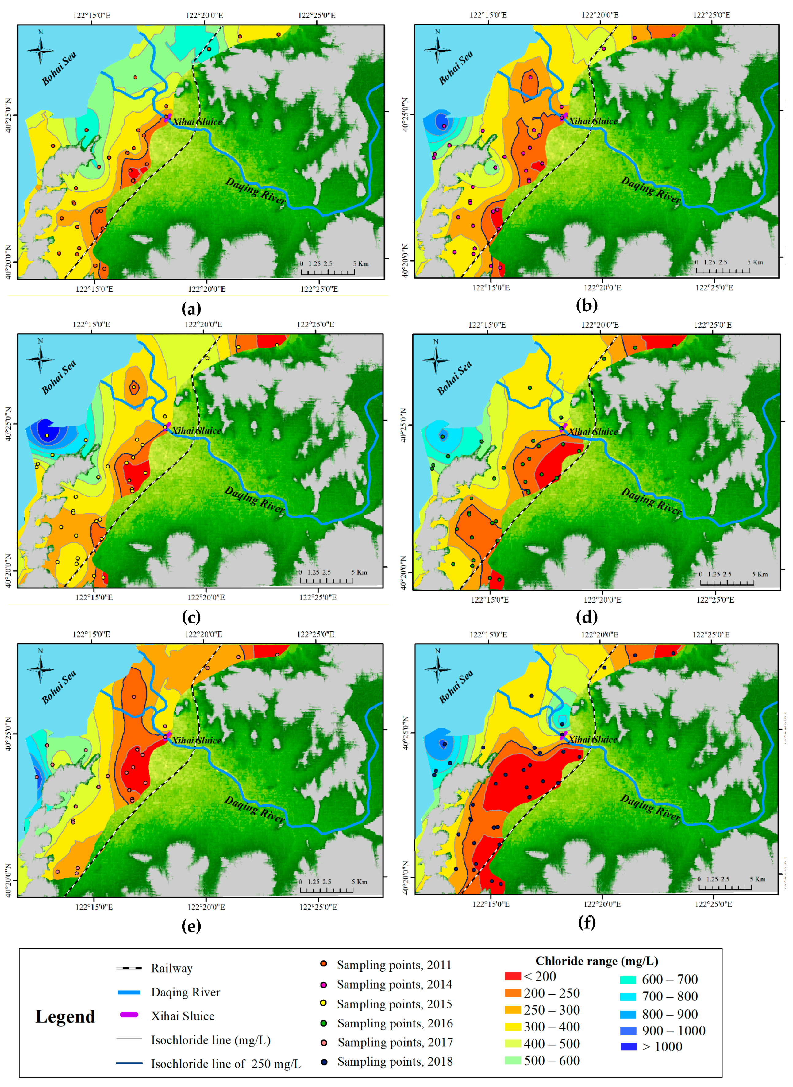
3.1. Hydrochemical Analysis

The spatial distribution maps of the historical chloride ion concentration of groundwater samples were drawn in ArcGIS based on the Geostatistical Analyst prediction maps (Figure 6).
Salinization typically followed the usual pattern of aquifers influenced by seawater intrusion, with a progressive decrease from the coast towards the interior. However, the situation in the study area is relatively complex because the Daqing River and the Xihai Sluice are in the lower reaches, which will have a great impact on the intrusion of salt water. In 2011 (Figure 6a), the chloride concentrations decreased, but the concentrations were still very high, and almost all were higher than 250 mg/L. The water quality was more seriously impacted to the north of Daqing River, and a zone with chloride concentrations higher than 400 mg/L gradually appeared along the estuary of the Daqing River.
To protect the groundwater resources, there has been a remarkable reduction in groundwater pumping in the water source area since 2012, and an overall improvement in water quality was noticed by 2014, as the chloride concentrations were less than 250 mg/L in many areas along the Daqing River, especially in the southern Daqing River and north of the river (Figure 6b). In 2015 (Figure 6c), the chloride concentrations showed an increase inland, and the saltwater zone with chloride concentrations higher than 250 mg/L on both sides of the Daqing River became wider. On the northern bank of the Daqing River, the saltwater zone slightly expanded and moved towards the southwest, but the area with chloride concentrations less than 250 mg/L expanded and a freshwater zone with chloride concentrations less than 200 mg/L appeared. In 2016 (Figure 6d), the substantial high salinity zone (chloride concentrations higher than 400 mg/L) on the northern bank of the Daqing River slightly shrunk but continued to moved towards the southwest. In the southwestern Daqing River, away from the Xihai Sluice, the area with chloride concentrations less than 250 mg/L extended. Overall, the chloride concentrations declined, and a freshwater zone with chloride concentrations less than 100 mg/L appeared. In 2017 (Figure 6e), chloride concentrations of the saltwater zone declined to less than 400 mg/L on the northern bank of the river. The chloride concentrations were less than 250 mg/L in many areas, especially along the Daqing River. In 2018 (Figure 6f), in the southern Daqing River, the chloride concentration declined significantly, and freshwater zones with chloride concentrations less than 200 mg/L became widespread. According to the chloride concentration of 250 mg/L, the seawater invasion continued to retreat back to the ocean. However, high-salinity areas to the north of the Daqing River appeared again.
The single index is simple and easy to operate, although the results are easily affected by the hydrogeological conditions and human activities, but this index could still be used as a guide for the trends in salinity in this study. However, the chloride ion concentration sampling points were concentrated along the northern Changda Railway, and there were several sampling points across the railway inland areas. Due to the trend of seawater intrusion, future seawater intrusion monitoring investigations should extend towards the inland area north of Daqing River. Historical hydrochemical data show that a reduction in groundwater pumping in the water source area is an effective measure to slow down seawater intrusion. The Daqing River plays an important role in the groundwater system of the study area. The sampling points near the Xihai Sluice show different fluctuations; some of them show a decreasing trend, while some show a large variation range, which indicates that the sluice has a moderating effect on seawater intrusion and that the affected range is small.

3.2. Geoelectrical Data

In seawater intrusion research, ERT is an effective method to quickly test the intrusion interface at the site, and it can be used for long-term monitoring. ERT is practical in areas with limited hydrochemical data. The key research area in this study was near the Xihai Sluice.
Some research showed that the resistivity of sands and gravels varies from 20 Ω-m to 50 Ω-m compared with the range of 1–10 Ω-m for clay resistivity [46]. The resistivity of the sandstone and unsaturated gravels exceeded 150 Ω-m, whereas the resistivity of the salty aquifer with sand and/or gravel material ranged between 0.1 and 15 Ω-m. The variations of the salt aquifer’s resistivity depended on the electrical conductivity of the groundwater and the material of the aquifer [6].
According to the comprehensive analysis of chloride concentrations in 2018, the seawater intrusion zone was located in the aquifer in the estuary of Daqing River. Test lines L01 and L02 were located near the southern estuary and the northern estuary, respectively, of the Daqing River (Figure 7). The direction of the line L01 wiring test was from the coastal to inland areas, which is approximately perpendicular to the coastal zone direction, with a length of 390 m. There were 40 electrodes, and the distance between each electrodes was 10 m. In total, 120 electrodes were used, with a unit electrode distance of 10 m, and the length of the line was 1190 m. The Wenner method was adopted to measure the two test lines. According to the inversion results of test lines L01 and L02 and the aquifer and geological conditions in the study area, the aquifer thickness was within the range of 10–50 m, and the salt aquifer had resistivity values varying from 0.1 to 15 Ω-m.
Test lines L03, L04 and L05 were located in areas without chloride concentration data. Lines L03 and L04 were measured by the Wenner method, and L05 was measured by the Schlumberger method. Test line L03, which is perpendicular to the coastline, was set up along the location near the railway line. Though the test line L03 was located in an area without chloride concentration data, it can be inferred from the isochloride line of 250 mg/L in the spatial distribution of chloride concentrations in 2018 (Figure 8) that seawater intrusion did not occur here, and the ERT result proved as much. In this section, we detected a formed, complete saturated aquifer at the depth of 20 to 65 m, with resistivity varying from 15 to 45 Ω-m. Test line L04 was located on the northern bank of the Daqing River, which is approximately 300 m from the river, parallel to the river channel and perpendicular to the sea coast. There were 120 electrodes in total, with a unit electrode distance of 3 m, and the length of the test line was 357 m. An abnormal area with high resistivity occurred at the position of 25–150 m long and 18–20 m deep on L04. Surveys and interviews indicated that the high-resistivity area may be a drainage pipe. At the depth of 50–60 m, part of the aquifer had resistivity values that varied from 0 to 15 Ω-m, and combined with the trend of the spatial distribution of chloride concentrations in 2018, this could be a seawater intrusion area. Test line L05 was arranged beside the western side of the Changda Railway with a line length of 207 m and 70 electrodes, and the unit electrode distance was 3 m. The Schlumberger arrangement method (for the depth of the measurement, and the level, at a higher resolution) was used to perform the measurement, and the depth of L05 was approximately 36.9 m. The surface of the sections L04 and L05 with low resistivity varied from 0 to 15 Ω-m, which were caused by agricultural fertilizers and irrigation.
Test line L06 (Figure 8) was located on the southern side of the Daqing River and was only 35 m away from the Daqing River. The total length of the test line after splicing was 447 m, and the effective depth after inversion was approximately 42 m. There was high resistivity at the position of 50 m in this test line, which may have been influenced by the pebbles. There was an area with resistivity varying from 0 to 15 Ω-m in front of the Xihai Sluice, which was located from 75 to 120 m at depths of 20–40 m. It showed that the seawater intrusion was controlled in the downstream of the Xihai Sluice. L07 was measured near the location of line L06 in the rainy season in September 2018 (Figure 8), and the Wenner method was used to extend the length of line L07. Depending on the resistivity results, the resistivity of the aquifer decreased generally in the rainy season. In addition, the seawater/freshwater interface was found in front of the Xihai Sluice, but a seawater zone (resistivity varying from 0 to 15 Ω-m) also appeared behind the sluice, which means the sluice only achieved limited control of seawater intrusion near the river in 2018. This result was consistent with the spatial distribution of chloride concentrations (Figure 6f).

4. Discussion

This study filled the blank of seawater intrusion research in Yingkou City, Lioaning Province. Compared with the previous research results, the hydrochemistry results of this experiment are more consistent with the ERT results in this study, which not only provided geoelectrical results of the aquifer in areas lacking chlorine concentration data, but also monitored the evolution of the saltwater interface in the rainy and dry seasons near the Xihai Sluice. The combined method provided enough information when analyzing the local seawater intrusion process.
Seawater intrusion in the Daqing River Catchment is mainly caused by the overexploitation of groundwater. According to the water resources bulletin of Yingkou, the total water consumption in 2016 was 755 million cubic meters, of which 544.8 million cubic meters were used for irrigation, accounting for 72.2% of the total water consumption. This area is mainly greenhouse planting, and the irrigation water demand is very high. Most of the pumping wells in the water source area are located on the southern bank of the Daqing River. Due to overexploitation, hydraulic gradients from the ocean to the inland were formed, which provided the hydrodynamic condition for seawater intrusion. When the groundwater was exploited extensively and in a highly concentrated way in water source areas, the groundwater level formed a local cone of depression centered on the water source area. The water level in the center of the depression cone is lower than the sea level, forming a hydraulic gradient pointing inland, which allowed the seawater to advance inland easily. In addition, the amount of local annual rainfall is lower than that the annual evaporation, and thus, the shortage of groundwater recharge is also a major reason for seawater intrusion. A simplified diagram of the local seawater intrusion process caused by overexploitation before 2012 is given in Figure 9 (Figure 9 is adapted to local condition based on Figure 1 of “Seawater intrusion processes, investigation and management: Recent advances and future challenges” [11]. In Figure 9, hydrogeological process of the aquifer is simplified, and the process of seawater intrusion due to overexploitation in water source areas is redrawn). In 2012, strict controls were placed on groundwater exploitation in this region, and the chloride concentration of 250 mg/L receded year by year. Although there were fluctuations in some years, the risk of seawater intrusion was significantly reduced by 2018.
The result of historical chloride concentration lines of 250 mg/L showed that seawater intrusion has been controlled near the Xihai Sluice in the past few years, which is also confirmed by ERT results from 2018. The upstream river runoff river rises in front of the sluice and then recharges the surrounding groundwater. Downstream, due to the tidal action, the seawater advances and reaches the downstream of the sluice along the river course. The saltwater recharges the groundwater, and because the freshwater level in the upper reaches is always higher than that in the lower reaches, a saltwater wedge is formed near the lower reaches of the sluice. After the rainy season, the water level of the river rises, and the freshwater in the river supplies the surrounding groundwater, raising the level of fresh groundwater and controlling the diffusion of seawater, and the resistivity of the nearby aquifer decreases as a whole.
In general, the Xihai Sluice plays an important role in the distribution and evaluation of seawater intrusion nearby the Daqing River, and if there are areas that have the same local topographical and geomorphic conditions, a river barrier can be used to adjust the groundwater level to control seawater advancement. At the same time, the most effective way to treat seawater intrusion caused by overexploitation is to reduce the amount of exploitation, and scientific and efficient water-saving irrigation means are essential in this area.

5. Conclusions

The extent and geometrical characteristics of seawater intrusion in the coastal aquifer of northeastern Liaodong Bay in China were studied using historical hydrochemical data, together with electrical resistivity tomography results. When groundwater chemical data are difficult to obtain, electrical resistivity tomography is a convenient method for rapid field testing, and the data can be used as a complement. ERT can be used to detect the front of the interface of the seawater intrusion mixing zone. Long-term monitoring with a higher frequency should be carried out in the study area.
Salinization followed the usual pattern of aquifers influenced by seawater intrusion, with a progressive decrease from the coast towards the interior, but the Daqing River has a great impact on seawater intrusion, which influences the salinity distribution, and the Xihai Sluice also has a great influence within a certain range in controlling the seawater intrusion. Scientific groundwater-saving measures are an effective way to address seawater intrusion, and strengthen the function of the river sluice will help controlling seawater intrusion.

Author Contributions

J.M. and Z.Z. conceived and designed the study; J.M., Z.Z., Q.G., S.Z., Y.D. and Q.S. collected the data and did the investigation; J.M. analyzed the data; J.M. wrote the paper with the assistance of Z.Z.

Funding

This research was supported by the National Key Research and Development Program of China (No.2016YFC0402803). Project also supported by National Natural Science Foundation of China (91747204, 41572209).

Acknowledgments

The field tests and historical data collecting were supported by Liaoning Hydrographic Bureau.

Conflicts of Interest

The authors declare that there are no conflicts of interest regarding the publication of this paper.

Appendix A

Table A1. Chloride concentration data in 2011, 2014–2018.
Well NumberWell Depth (m)East Longitude (°)North Latitude (°)Chloride Concentration (mg/L)
201120142015201620172018
15122.20940.394861.0363.0584.0666.0
29122.20840.392182.081.5297.01370.0750.0
315122.24540.407968.0184.0798.0701.0629.0351.0
4122.28940.388153.0158.0108.0156.0175.0102.0
555122.27940.379691.0443.0412.0558.0395.0312.0
634122.27940.378381.049.528.028.4148.077.1
710122.27740.38428.4141.0124.0149.0147.096.2
820122.27540.39467.463.077.673.883.3111.0
9122.25440.386957.01080.0794.0759.0471.080.5
1042122.26140.392152.087.2109.0107.0271.0107.0
1125122.23740.375470.0376.0301.0107.0473.0138.0
1230122.23540.367434.0471.0359.0229.0397.0349.0
139122.23540.366183.0319.0269.0210.0286.0178.0
1410122.25640.351142.0196.0168.0171.0131.0
1535122.25240.361142.074.697.5106.0147.0
1620122.25540.362220.086.5428.0437.0408.0
1730122.23740.353354.0266.0284.0140.0207.0
18100122.22640.358177.0142.0204.0184.0275.0
1941122.23840.340354.0358.0431.0302.0196.064.9
2040122.23740.337354.0371.0381.0386.0351.0292.0
2117122.22340.338418.0362.0297.0497.0197.0342.0
2215122.25040.330386.0371.0297.0195.0195.0
2315122.25740.32988.644.1110.070.870.8
2421122.28740.404129.0267.0230.0198.0263.0315.0
2530122.28040.397691.0307.0341.0332.0181.0110.0
2628122.30040.38672.890.486.978.1
272.7122.38840.460253.0163.0136.038.135.3138.0
283.7122.35940.459303.0245.0175.0219.0323.0225.0
2915122.33640.453975.0636.0629.0389.0263.0333.0
304122.30440.41489.358.789.575.365.183.3
3125122.31740.40187.270.9
3238122.30540.405106.079.8
3350122.28340.407266.0316.0341.0294.0146.0332.0
3412122.30440.420459.0590.0991.0614.01330.0
356122.28140.437674.0102.099.3119.0120.0119.0
365122.21640.4101620.01641.01120.0596.01120.0
3720122.22040.399213.0137.0585.0790.0227.0790.0
38122.30540.421350.0
Table A2. Prediction map error.
YearSamplesRoot Mean SquareAverage Standard ErrorRoot Mean Square StandardizedMean Standardized
201131282.7721249.32091.111113−0.03225523
201434364.7909290.67431.22782−0.02074895
201534303.5656257.44641.139398−0.01661148
201637265.64247.53371.073861−0.01579005
201729274.8583206.64571.278168−0.003257827
201837268.4905235.98311.145663−0.002707003

References

  1. Cartwright, N. Experimental observations of watertable waves in an unconfined aquifer with a sloping boundary. Adv. Water Resour. 2004, 27, 991–1004. [Google Scholar] [CrossRef]
  2. Carey, H.; Lenkopane, M.K.; Werner, A.D.; Li, L.; Lockington, D.A. Tidal controls on coastal groundwater conditions: Field investigation of a macrotidal system. Aust. J. Earth Sci. An. Int. Geosci. J. Geol. Soc. Aust. 2009, 56, 1165–1179. [Google Scholar] [CrossRef]
  3. Slooten, L.J.; Carrera, J.; Castro, E.; Fernandez-garcia, D. A sensitivity analysis of tide-induced head fluctuations in coastal aquifers. J. Hydrol. 2010, 393, 370–380. [Google Scholar] [CrossRef]
  4. Bakhtyar, R.; Barry, D.A.; Brovelli, A. Numerical experiments on interactions between wave motion and variable-density coastal aquifers. Coast. Eng. 2012, 60, 95–108. [Google Scholar] [CrossRef] [Green Version]
  5. Green, N.R.; Macquarrie, K.T.B. An evaluation of the relative importance of the effects of climate change and groundwater extraction on seawater intrusion in coastal aquifers in Atlantic Canada. Hydrogeol. J. 2014, 22, 609–623. [Google Scholar] [CrossRef]
  6. Kazakis, N.; Pavlou, A.; Vargemezis, G.; Voudouris, K.S.; Soulios, G.; Pliakas, F.; Tsokas, G. Seawater intrusion mapping using electrical resistivity tomography and hydrochemical data. An application in the coastal area of eastern Thermaikos Gulf, Greece. Sci. Total Environ. 2015, 543, 373–387. [Google Scholar] [CrossRef]
  7. García-Menéndez, O.; Morell, I.; Ballesteros, B.J.; Renau-Prunonosa, A.; Renau-Llorens, A.; Esteller, M.V. Spatial characterization of the seawater upconing process in a coastal Mediterranean aquifer (Plana de Castello, Spain): Evolution and controls. Environ. Earth Sci. 2016, 75, 728. [Google Scholar] [CrossRef] [Green Version]
  8. Kaleris, V.K.; Ziogas, A.I. The effect of cutoff walls on saltwater intrusion and groundwater extraction in coastal aquifers. J. Hydrol. 2013, 476, 370–383. [Google Scholar] [CrossRef]
  9. Van Pham, H.; Lee, S. Assessment of seawater intrusion potential from sea- level rise and groundwater extraction in a coastal aquifer. Desalin. Water Treat. 2015, 53, 2324–2338. [Google Scholar] [CrossRef]
  10. Taniguchi, M.; Burnett, W.C.; Cable, J.E.; Turner, J.V. Investigation of submarine groundwater discharge. Hydrol. Process. 2002, 2129, 2115–2129. [Google Scholar] [CrossRef]
  11. Werner, A.D.; Bakker, M.; Post, V.E.A.; Vandenbohede, A.; Lu, C.; Ataie-ashtiani, B.; Simmons, C.T.; Barry, D.A. Seawater intrusion processes, investigation and management: Recent advances and future challenges. Adv. Water Resour. 2013, 51, 3–26. [Google Scholar] [CrossRef]
  12. Shi, L.; Jimmy, J. Seawater intrusion and coastal aquifer management in China: A review. Environ. Earth Sci. 2014, 72, 2811–2819. [Google Scholar] [CrossRef]
  13. Mastrocicco, M.; Busico, G.; Colombani, N.; Vigliotti, M.; Ruberti, D. Modelling actual and future seawater intrusion in the Variconi Coastal Wetland (Italy) due to climate and landscape changes. Water 2019, 11, 1502. [Google Scholar] [CrossRef] [Green Version]
  14. Kazakis, N.; Busico, G.; Colombani, N.; Mastrocicco, M. GALDIT-SUSI a modified method to account for surface water bodies in the assessment of aquifer vulnerability to seawater intrusion. J. Environ. Manag. 2019, 235, 257–265. [Google Scholar] [CrossRef]
  15. Bryan, E.; Meredith, K.T.; Baker, A.; Post, V.E.A.; Martin, S. Island groundwater resources, impacts of abstraction and a drying climate: Rottnest Island, Western Australia. J. Hydrol. 2016, 542, 704–718. [Google Scholar] [CrossRef]
  16. National Bureau of Statistics of China China Statistical Yearbook 2011; China Statistics Press: Beijing, China, 2011.
  17. Abarca, E.; Carrera, J.; Sa’nchez-Vila, X.; Dentz, M. Anisotropic dispersive Henry problem. Adv. Water Resour. 2007, 30, 913–926. [Google Scholar] [CrossRef]
  18. Fahs, M.; Ataie-Ashtiani, B.; Younes1, A.; Simmons, C.T.; Ackerer, P. The Henry problem: New semianalytical solution for velocity-dependent dispersion. Water Resour. Res. 2016, 52, 7382–7407. [Google Scholar] [CrossRef]
  19. Paster, A.; Dagan, G.; Guttman, J. The salt-water body in the Northern part of Yarkon-Taninim aquifer: Field data analysis, conceptual model and prediction. J. Hydrol. 2006, 323, 154–167. [Google Scholar] [CrossRef]
  20. Goswami, R.R.; Clement, T.P. Laboratory-scale investigation of saltwater intrusion dynamics. Water Resour. Res. 2007, 43, 1–11. [Google Scholar] [CrossRef]
  21. Abarca, E.; Prabhakar Clement, T. A novel approach for characterizing the mixing zone of a saltwater wedge. Geophys. Res. Lett. 2009, 36, 1–5. [Google Scholar] [CrossRef] [Green Version]
  22. Sathish, S.; Elango, L.; Rajesh, R.; Sarma, V.S. Application of three dimensional Electrical Resistivity Tomography to identify seawater intrusion. Earth Sci. India 2011, 4, 21–28. [Google Scholar]
  23. Jakovovic, D.; Werner, A.D.; Simmons, C.T. Numerical modelling of saltwater up-coning: Comparison with experimental laboratory observations. J. Hydrol. 2011, 402, 261–273. [Google Scholar] [CrossRef]
  24. Price, R.M.; Top, Z.; Happell, J.D.; Swart, P.K. Use of tritium and helium to define groundwater flow conditions in Everglades National Park. Water Resour. Res. 2003, 39, 1267. [Google Scholar] [CrossRef]
  25. Barlow, P.M. Ground Water in Freshwater-Saltwater Environments of the Atlantic Coast; U.S. Department of the Interior, U.S. Geological Survey: Washington, DC, USA, 2003.
  26. Acworth, R.I.; Dasey, G.R. Mapping of the hyporheic zone around a tidal creek using a combination of borehole logging, borehole electrical tomography and cross-creek electrical imaging, New South Wales, Australia. Hydrogeol. J. 2003, 11, 368–377. [Google Scholar]
  27. Ewing, R.P.; Hunt, A.G. Dependence of the electrical conductivity on saturation in real porous media. Vadose Zone J. 2006, 5, 731–741. [Google Scholar] [CrossRef]
  28. Henderson, R.D.; Day-lewis, F.D.; Abarca, E.; Harvey, C.F.; Karam, H.N.; Liu, L.; Lane, J.W. Marine electrical resistivity imaging of submarine groundwater discharge: Sensitivity analysis and application in Waquoit Bay, Massachusetts, USA. Hydrogeol. J. 2010, 18, 173–185. [Google Scholar] [CrossRef]
  29. de Franco, R.; Biella, G.; Tosi, L.; Teatini, P.; Lozej, A.; Chiozzotto, B.; Giada, M.; Rizzetto, F.; Claude, C.; Mayer, A.; et al. Monitoring the saltwater intrusion by time lapse electrical resistivity tomography: The Chioggia test site (Venice Lagoon, Italy). J. Appl. Geophys. 2009, 69, 117–130. [Google Scholar] [CrossRef]
  30. Mertzanides, Y.; Economou, N.; Hamdan, H.; Vafidis, A. Imaging seawater intrusion in coastal zone of Kavala (N.Greece) with electrical reisistivity tomography. Bull. Geol. Soc. Greece 2017, 43, 1802–1811. [Google Scholar] [CrossRef] [Green Version]
  31. Boluda-Botella, N.; Gomis-Yagües, V.; Ruiz-Beviá, F. Influence of transport parameters and chemical properties of the sediment in experiments to measure reactive transport in seawater intrusion. J. Hydrol. 2008, 357, 29–41. [Google Scholar] [CrossRef] [Green Version]
  32. Gime’nez-Forcada, E. Space/time development of seawater intrusion: A study case in Vinaroz coastal plain (Eastern Spain) using HFE-Diagram, and spatial distribution of hydrochemical facies. J. Hydrol. 2014, 517, 617–627. [Google Scholar] [CrossRef]
  33. Archie, G.E. The electrical resistivity log as an aid in determining some reservoir characteristics. Trans. AIME 1942, 146, 54–61. [Google Scholar] [CrossRef]
  34. Mualem, Y.; Friedman, S.P. Theoretical prediction of electrical conductivity in saturated and unsaturated soil. Water Resour. Res. 1991, 27, 2771–2777. [Google Scholar] [CrossRef]
  35. Wilson, S.R.; Ingham, M.; Mcconchie, J.A. The applicability of earth resistivity methods for saline interface definition. J. Hydrol. 2006, 316, 301–312. [Google Scholar] [CrossRef]
  36. Nassir, S.S.A.; Loke, M.H.; Lee, C.Y.; Nawawi, M.N.M. Salt-water intrusion mapping by geoelectrical imaging surveys. Geophys. Prospect. 2010, 48, 647–661. [Google Scholar] [CrossRef]
  37. Bighash, P.; Murgulet, D. Application of factor analysis and electrical resistivity to understand groundwater contributions to coastal embayments in semi-arid and hypersaline coastal settings. Sci. Total Environ. 2015, 532, 688–701. [Google Scholar] [CrossRef] [PubMed]
  38. Francés, A.P.; Ramalho, E.C.; Fernandes, J.; Groen, M.; Hugman, R.; Khalil, M.A.; De Plaen, J.; Monteiro Santos, F.A. Contributions of hydrogeophysics to the hydrogeological conceptual model of the Albufeira-Ribeira de Quarteira coastal aquifer in Algarve, Portugal. Hydrogeol. J. 2015, 23, 1553–1572. [Google Scholar] [CrossRef]
  39. Morrow, F.J.; Ingham, M.R.; Mcconchie, J.A. Monitoring of tidal influences on the saline interface using resistivity traversing and cross-borehole resistivity tomography. J. Hydrol. 2010, 389, 69–77. [Google Scholar] [CrossRef]
  40. Ebraheem, A.M.; Sherif, M.; Akram, S.; Shetty, A.V. A geoelectrical and hydrogeological study for the assessment of groundwater resources in Wadi Al Bih. Environ. Earth Sci. 2012, 67, 845–857. [Google Scholar] [CrossRef]
  41. Kim, K.Y.; Chon, C.M.; Park, K.H. A simple method for locating the fresh water-salt water interface using pressure data. Groundwater 2010, 45, 723–728. [Google Scholar] [CrossRef]
  42. Zarroca, M.; Bach, J.; Linares, R.; Pellicer, X.M. Electrical methods (VES and ERT) for identifying, mapping and monitoring different saline domains in a coastal plain region (Alt Empordà, Northern Spain). J. Hydrol. 2011, 409, 407–422. [Google Scholar] [CrossRef]
  43. Goebel, M.; Pidlisecky, A.; Knight, R. Resistivity imaging reveals complex pattern of saltwater intrusion along Monterey coast. J. Hydrol. 2017, 551, 746–755. [Google Scholar] [CrossRef]
  44. Wu, Z.; He, M.; Ni, Z. The assessment of localized remobilization and geochemical process of 14 metals at sediment/water interface (SWI) of Yingkou coast (China) by diffusive gradients in thin films (DGT). Environ. Earth Sci. 2014, 73, 6081–6090. [Google Scholar] [CrossRef]
  45. Wu, Z.; He, M.; Lin, C. Environmental impacts of heavy metals (Co, Cu, Pb, Zn) in surficial sediments of estuary in Daliao River and Yingkou Bay (northeast China): Concentration level and chemical fraction. Environ. Earth Sci. 2012, 2417–2430. [Google Scholar] [CrossRef]
  46. Vargemezis, G.; Fikos, I. Large scale vertical electrical soundings survey in Anthemountas river basin for evaluating hydraulic communication between sub basin aquifers. Bull. Geol. Soc. Greece 2010, 43, 1953–1961. [Google Scholar] [CrossRef] [Green Version]
Figure 1. Location map of the study area.
Sustainability 11 07013 g001
Figure 2. Average monthly precipitation/evaporation/temperature from 2000 to 2016.
Sustainability 11 07013 g002
Figure 3. The average water exploitation amount of four water source areas per day before 2012 and after 2012.
Sustainability 11 07013 g003
Figure 4. Hydrogeological cross-section of the downstream Daqing River (I–I’). (This figure was plotted based on the hydrogeological section figure of the hydrogeological exploration report of the valley plain at the lower reaches of Daqing River in Gai County provided by Liaoning Hydrographic Bureau.).
Sustainability 11 07013 g004
Figure 5. Electrical resistivity tomography test lines arrangement in 2018.
Sustainability 11 07013 g005
Figure 6. Spatial distribution of chloride concentrations: (a) spatial distribution of chloride concentrations in 2011; (bf) spatial distribution of chloride concentrations from 2014 to 2018.
Sustainability 11 07013 g006
Figure 7. Electrical resistivity tomographies (L01–L05) at the study site.
Sustainability 11 07013 g007
Figure 8. Electrical resistivity tomographies (L06 and L07) at the study site.
Sustainability 11 07013 g008
Figure 9. Simplified schematic diagram of the local seawater intrusion process caused by overexploitation before 2012. (It was simplified and adapted to local condition based on Figure 1 of “Seawater intrusion processes, investigation and management: Recent advances and future challenges” [11].).
Sustainability 11 07013 g009

