1. Introduction
Terrestrial vegetation is a product of the interactions among the atmosphere, lithosphere, pedosphere, hydrosphere, and biosphere. It is an important link that connects climate change, human activities, and ecosystems. Climate and human activities are the basic drivers for controlling and affecting the spatial distribution of vegetation and its changes [
1,
2,
3]. Climatic factors control the growth process of vegetation on a long-term scale, restrict the geographical distribution of terrestrial vegetation, and determine the type and magnitude of regional ecosystem services. Human activities have changed the geographical extent and quality of vegetation growth on a short time scale and have had a major impact on regional ecosystem services and functions [
4,
5]. An in-depth analysis of the impact of climate change and human activities on changes to vegetation cover can provide a quantitative assessment of the contribution rate of the two types of driving factors that have been key issues in global change research but are also challenging to research [
6,
7]. Some biophysical parameters that have been obtained by satellite remote sensing inversion, such as the normalized difference vegetation index (NDVI), Albedo, and the leaf area index (LAI), can characterize the specific nature of ecosystems so that researchers can use satellite remote sensing inversion and simulation techniques to conduct long-term ecological monitoring and evaluation. In this way, the spatial distribution characteristics and the dynamic evolution of terrestrial ecosystems can be revealed [
8,
9]. Among the parameters, the NDVI is used as a proxy to analyze the impact of climate change and human activities on the NDVI of terrestrial vegetation. This is an important part of applying remote sensing technology to monitor regional vegetation changes and to deepen the driving mechanism [
10,
11].
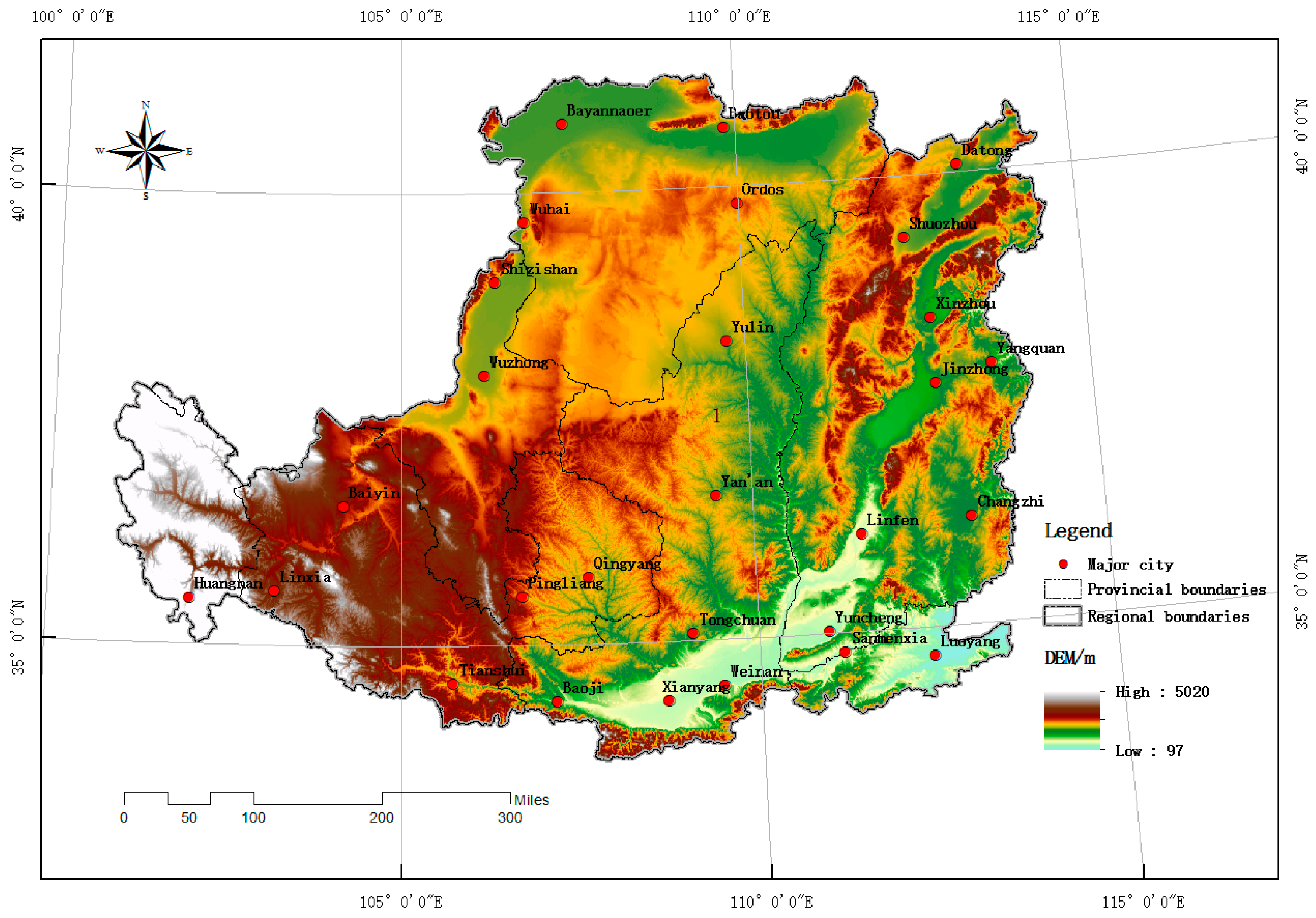
The Loess Plateau is one of the regions with the most serious levels of soil erosion in China and in the world. The Loess Plateau has broken terrain, loose soil, concentrated precipitation, and vegetation degradation, and these characteristics make the plateau a typical ecologically fragile area [
12,
13,
14]. To curb the deteriorating ecological environment of the Loess Plateau, China’s central government and local governments have long carried out land degradation management with soil and water conservation as the core [
15,
16]. Since 1978, the Chinese government has carried out the “Three-North Protection Forest System Construction Project” in the Loess Plateau. Since 1999, based on the experience of the Chinese Academy of Sciences in soil and water conservation and management in the Yan’an area, the central government has carried out large-scale ecological restoration and treatment projects, such as “returning farmland to forests and grasslands” (or the “Grain for Green” Program (GGP)) and “closing hillsides for afforestation” in the region [
17,
18]. After long-term unremitting efforts, the vegetation of the Loess Plateau has been significantly restored, and the regional ecological quality and ecological service functions have been significantly improved [
19,
20,
21,
22]. It is generally believed that the abundant light energy resources and thermal resources in the Loess Plateau can fully meet the basic needs of vegetation growth in the region. Precipitation and the soil moisture status have become the basic limiting factors for land vegetation cover and change. Human activities, including land reclamation, returning farmland to forests and grassland, and other land development and ecological protection and engineering control activities, have affected the composition, growth quality, and growth of the Loess Plateau under the constraints of light, heat, and water conditions. Therefore, the spatial and temporal patterns and changes to the terrestrial vegetation on the Loess Plateau over the past few decades are summarized in this paper. The degree of impact of climate change and human activities on vegetation changes is analyzed in depth. This is an assessment of the effectiveness of the Chinese government in ecological restoration and treatment construction on the Loess Plateau, which is also the basis for assessing where future human interventions can play a role [
23,
24]. The basic data and basic conclusions that were formed can provide strong scientific support for agricultural development, ecological protection, and governance in the Loess Plateau.
Researchers at home and abroad have carried out many studies on the spatial distribution pattern, dynamic change, and the influencing mechanism of vegetation on the Loess Plateau. For example, Xiao [
25] used MODIS series products to systematically analyze the impact of the GCP program on the biophysical characteristics of vegetation in the Loess Plateau. Studies have shown that since the implementation of the GGP, the average tree coverage and enhanced vegetation index (EVI), the leaf area index, and the photosynthetically active radiation ratio of vegetation canopy absorption have increased significantly. In addition, the GCP has also significantly reduced the surface albedo and surface temperature during the day, which has had a cooling effect on the climate. Liu [
26] extracted the vegetation coverage data based on the MODIS NDVI from 2000 to 2008 and pointed out that the vegetation coverage of the Loess Plateau showed a rapid increase and a partial decline. After comparing the changes in vegetation cover in the soil use/cover change zone and the unaltered zone, the authors pointed out that human activities have an important impact on the vegetation cover change. However, the authors did not further analyze the mechanisms and effects of the factors that drive the spatial and temporal changes in vegetation coverage (climate change and human activities). Shi [
27] applied the Carnegie–Ames–Stanford Approach (CASA) model to simulate the net primary productivity (NPP) of the ecosystem and pointed out that before the implementation of the project of returning farmland to forests and grasslands (1982–1998), the NPP changes in most areas of the Loess Plateau were not obvious. However, after the implementation of the project of returning farmland to forests and grasslands, the increase in the vegetation NPP became significant. By comparing the temporal evolution characteristics of vegetation activities and returning farmland to forests and grassland projects, this study qualitatively points out that ecological protection and treatment projects, such as returning farmland to forests, have an important role in improving regional vegetation conditions. However, this is a correlation-based qualitative analysis. Yi [
28] used the SPOT VGT data of the Loess Plateau from 1999 to 2010 to analyze the influence of the NDVI cumulative value and precipitation in the growing season and applied the residual method to analyze climate change in the Loess Plateau and the impact of human activities on the vegetation cover change. However, this study only compared changes in the NDVI and in the precipitation during the same growing season and did not consider the hysteresis effect of vegetation growth relative to precipitation. On the other hand, the study failed to give a quantitative contribution of climate change and human activity factors on regional NDVI changes.
To sum up, an in-depth analysis of the effects of climate change and human activities on vegetation cover change has been one of the key elements of global change research. A quantitative assessment of the contribution rates of two types of drivers, climate change and human activities, is a key issue in the study of vegetation change. Most of the past studies have directly described changes in the terrestrial vegetation but have not provided an in-depth explanation of the driving mechanism. The few studies on the driving mechanism were based on a qualitative analysis of correlation and a trend comparison. The aim of the present study was therefore to develop a relatively simple and direct method to isolate the impact of climatic factors on regional vegetation growth and to determine the extent of non-meteorological factors (mainly human activities) on vegetation growth and change. For this, we selected the Loess Plateau as the study area, applied a complex linear regression analysis and residual analysis using MODIS NDVI and surface meteorological station monitoring data from 2000 to 2015, and attempted to separate the contributions of meteorological factors on the vegetation index to achieve a quantitative determination of the NDVI change and the contribution rate of the driving factors in the Loess Plateau in recent years. The study tried to answer the following two sets of questions:
What is the trend of vegetation change in the Loess Plateau since 2000? Has the vegetation in those areas become greener?
How much does climate change contribute to regional vegetation changes? Where do non-meteorological elements play a role?
3. Result Analysis
3.1. The NDVI Difference between Two Time Sections
In 2015, the NDVI value in most areas of the Loess Plateau increased from that in 2000 (
Figure 3). The areas with an NDVI increase totaled 523,285 km
2, which accounted for 84.1% of the total area of the Loess Plateau. The area ratio of the areas where the NDVI increased by 0–0.2 was 69.0%, and the area ratio of the areas with an NDVI that increased by 0.2–0.1 was 15.1%. The areas with an NDVI reduction totaled 99,159 km
2, which accounted for 15.9% of the total area of the Loess Plateau. The area ratio of the areas where the NDVI was reduced by 0–0.2 was 15.5%, and the area ratio of the areas where the NDVI was reduced by 0.2–0.7 was 0.4%.
From a regional perspective, areas in the southern part of the Shanxi Province (Linyi, Yuncheng), the northern and central parts of Shaanxi Province (Yulin, Yan’an), and the eastern part of Gansu Province (Qingyang, Pingliang and Tianshui) are mainly loess hills and mountains. There was a significant increase in the NDVI values in these areas.
Areas in the northern part of Shanxi (Datong–Zhangzhou), the Luoyang Basin in Henan (Luoyang), the Guanzhong Plain in Shaanxi (Xi’an–Xianyang), and the central part of Gansu (Lanzhou–Baiyin) (these areas are mainly fast-growing urban agglomerations), as well as areas in the western and northern parts of the Ordos Plateau in Inner Mongolia (Muus Sandy Land, Kubuqi Desert), showed a significant decline in NDVI.
3.2. Trends in NDVI over the Past 16 Years
Since 2000, the NDVI of the Loess Plateau had increased (the average slope of the change was 0.007/a), without considering the significance of the change (
Figure 4).
From the perspective of space, NDVI in most areas had an increasing trend, which indicates that the vegetation on the Loess Plateau has improved. The area with an increasing trend of NDVI was approximately 577,825 km2, accounting for 92.6% of the total area of the Loess Plateau. Similar to the results of the NDVI difference analysis based on the two time sections, the areas where the NDVI showed an upward trend were mainly distributed in the southern part of the Shanxi Province (Linyi, Yuncheng), the northern and central parts of Shaanxi Province (Yulin, Yan’an), and the eastern part of Gansu Province (Qingyang, Pingliang, and Tianshui). These are mainly loess hills and mountains.
The area that showed a reduced NDVI was approximately 46,043 km2, with an area ratio of approximately 7.4%. Similar to the previous NDVI difference analysis results based on the two time sections, the NDVI that showed a decreasing trend was mainly distributed in the northern part of Shanxi (Datong–Zhangzhou, Changzhi), Henan’s Luoyang Basin (Luoyang), Shaanxi’s Guanzhong Plain (Xi’an–Xianyang), central Gansu (Lanzhou–Silver), and other regions (rapidly developed urban agglomerations), as well as the western and northern parts of the Ordos Plateau in Inner Mongolia (Muus Sandy Land, Kubuqi Desert).
A significant test of the
p = 0.05 level was performed on the above NDVI trends (
Figure 5). We found that the significant increase in the NDVI was still in the mainstream of vegetation change in the study area, accounting for 64.6% of the total area of the Loess Plateau. The area where the NDVI increased but failed the test accounted for 28.0%, the area where the NDVI decreased significantly only accounted for 1.3% of the Loess Plateau, and the area where the NDVI decreased but not significantly accounted for 6.1%. The areas that passed the significance test were mainly located in the eastern, central, and southern parts of the Loess Plateau; the areas that did not pass the significance test (including the NDVI rise and the NDVI decline) were mainly located in the eastern, northern, and western marginal areas of the study area and were distributed especially in the Ordos Plateau and in the area west of Liupanshan Mountain.
3.3. Estimation of the Contribution Rate of Driving Factors
In 2015, the contribution rate of meteorological factors on the vegetation NDVI was highest in the western part of the study area (Loess Plateau), slightly lower in the eastern and southern parts of the study area, and lowest in the central and southwestern regions (
Figure 6). Specifically, in the northern and western Ordos Plateau, Gansu Province and Qinghai Province, the area west of Liupanshan Mountain, and most of Shanxi Province, southern and the central part of Shaanxi, meteorological factors contributed significantly to the NDVI. Its contribution rate was basically above 80%. In the eastern part of Gansu Province (Qingyang, Pingliang, Tianshui), northwestern Shaanxi Province (Yan’an, Yulin), and southeastern Ordos, Inner Mongolia, the contribution rate of meteorological factors was small. Its contribution rate was basically less than 70%.
Spatial statistics showed that in 2015, the average contribution rate of meteorological factors (temperature, precipitation) to NDVI in the Loess Plateau was 87.7%, that is, the size of the NDVI in the Loess Plateau was generally controlled by meteorological elements. Among them, the area of the meteorological element contribution rate that was greater than 80% accounted for 81.0% of the total area of the region, while the area with meteorological element contribution rate less than 80% only accounted for 19.0% of the total area of the region (
Figure 7).
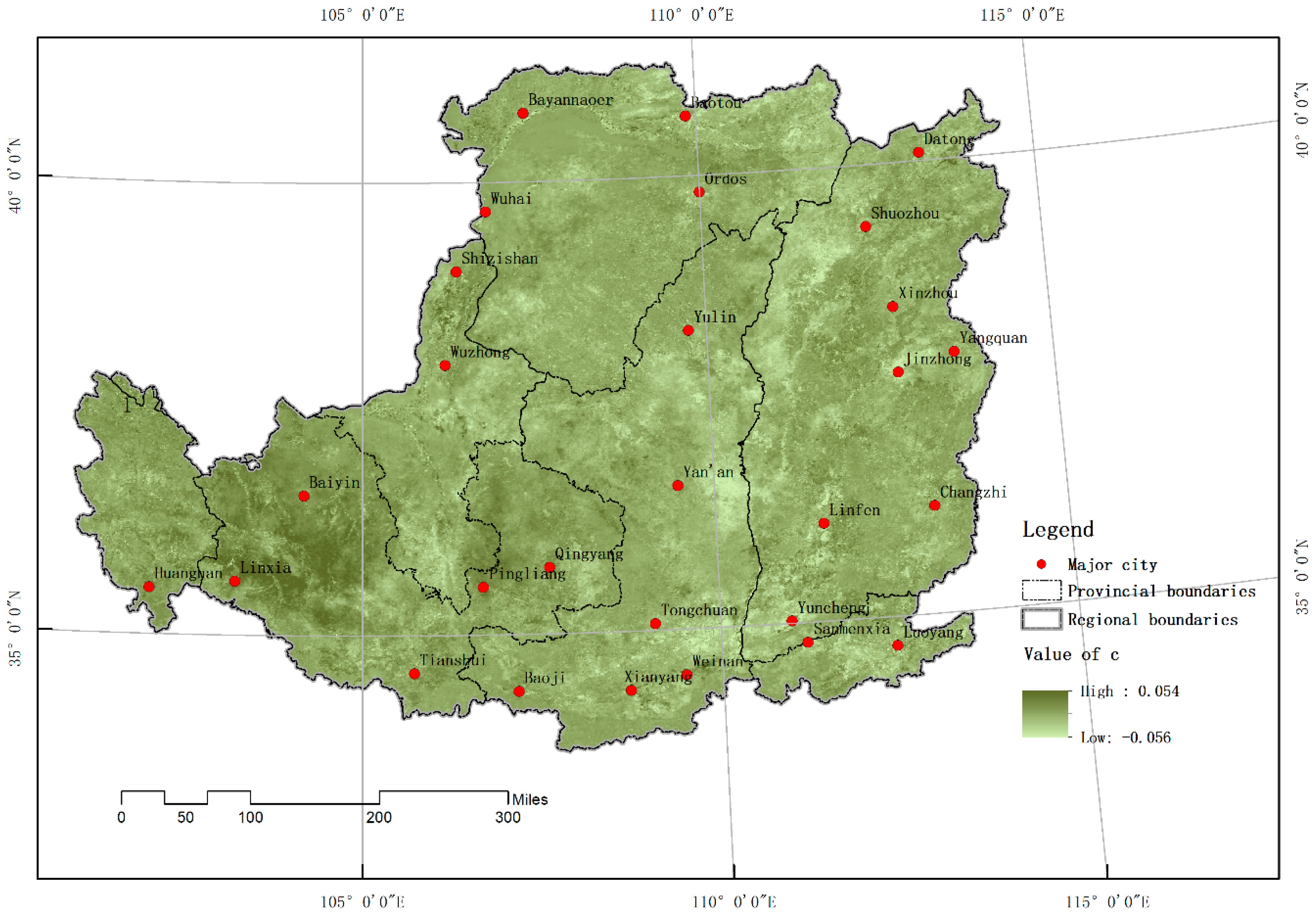
On the other hand, non-meteorological factors (mainly human activities) had a significant impact on the vegetation NDVI in different regions (
Figure 8). The areas where non-meteorological factors weakened the vegetation NDVI (i.e., regions with a Cr less than 0) were mainly distributed in the western part of the study area, namely, the northern and western parts of the Ordos Plateau in Inner Mongolia and most of the western part of Liupanshan Mountain. At the same time, there were also urban agglomerations in the eastern and southern parts of the Loess Plateau (Northern Shanxi Province, Shaanxi Guanzhong Plain, Luoyang Basin, etc.). Such areas accounted for 29.3% of the total area of the Loess Plateau.
The areas where non-meteorological factors (mainly human activities) significantly enhanced the vegetation index (i.e., regions with Cr greater than 0) were mainly distributed in the eastern and southern parts of the study area (except for urban agglomerations in these areas). This type of area accounted for 70.7% of the total area of the Loess Plateau.
From a spatial statistical point of view (
Figure 9), the average contribution of non-meteorological factors (mainly human activities) to NDVI in the Loess Plateau was 6.4%. In other words, non-meteorological factors generally improved the NDVI of the Loess Plateau vegetation. Among them, the area with an obvious promotion effect on the vegetation cover (that is, contribution rate of more than 20%) accounted for 15.1%. The area that showed significant inhibition of vegetation cover (i.e., contribution rate of less than −20%) accounted for only 3.8%. Obviously, non-meteorological factors (mainly human activities) play an important role in improving vegetation in the region.
4. Discussion
Regardless of the simple difference analysis of NDVI in two time sections (2000 and 2015) or the NDVI trend analysis over 16 years (2000–2015), the results that were obtained by the two research methods all reflected extremely similar NDVI spatiotemporal variation characteristics. Both methods showed that the vegetation cover in most areas of the Loess Plateau increased from 2000 to 2015, and it was mainly distributed in the southern part of Shanxi, the central and northern parts of Shaanxi, and in the eastern part of Gansu. This is consistent with the findings of other researchers [
39,
40]. Compared with Xiao’s research results [
39], the authors believe that the area with a larger area ratio in the Loess Plateau has become “greener” (84.6% vs. 78.6%). This is because the monitoring period of this paper is longer (2000–2015 vs. 2000–2010). In the five years after 2010, a number of ecological construction projects (including the Three-North Shelterbelt Project, the Returning Farmland to Forests and Grasses Project, the Beijing–Tianjin Sandstorm Source Project, etc.) continued to be implemented, and the vegetation on the Loess Plateau was further sustained and improved. This means that at least 6% of the vegetation in the Loess Plateau was improved and restored during these five years.
In the southwestern part of Shanxi (Linyi, Yuncheng), central and northern Shaanxi (Yan’an, Yulin), and the Liupanshan Mountain area (Qingyang, Pingliang, Tianshui) in eastern Gansu, human activities actually increased the NDVI value of vegetation. The loess types in these areas are mainly loess hills and mountains. In the past few decades, especially since the implementation of the GCP in 1999, the central government has implemented the project of returning farmland to forests and grasslands in the Loess Plateau. For areas with a slope of more than 25°, the original cultivated land is required to be withdrawn, and fruit trees and shrubs have been planted. At the same time, for a certain period of time, farmers will be provided with appropriate subsidized food, seedling afforestation fees, and cash (living expenses) subsidies for free. Each acre of farmland subsidizes 100 kg of grain and 20 yuan of cash per year. The afforestation fee of 50 yuan is subsidized for each acre of cultivated land, Yilin barren hills, and wasteland. There are different subsidies for different postrecovery vegetation. The ecological forest subsidy is eight years, the economic forest subsidy is five years, and the grassland subsidy is two years. Obviously, the central government’s returning farmland to forests and grassland activities have played a key role in the restoration of regional vegetation. In the western part of the Loess Plateau, the northern and western parts of the Ordos Plateau in Inner Mongolia, most of the area west of Liupanshan Mountain, and urban agglomerations in the eastern and southern parts of the Loess Plateau (Northern Shanxi Province, Shaanxi Guanzhong Plain, Henan Luoyang Basin, etc.; e.g., Xi’an–Xianyang–Weinan, Lanzhou–Baiyin, Luoyang, Datong–Zhangzhou–Jinzhong), human activities have actually reduced the NDVI value of vegetation based on meteorological elements. Since 2005, China’s economy has developed rapidly, and large-scale “making cities” have appeared in vast areas of China, including the Loess Plateau. The rapid development of new towns has taken up existing farmland, grassland, and woodland, which has resulted in a reduction in the surface NDVI. Therefore, the phenomenon of NDVI reduction in these urbanized areas is completely understandable.
Vegetation changes in the Loess Plateau are generally subject to meteorological elements. However, in some areas, the influence of non-meteorological factors on the vegetation NDVI dominates. This conclusion is consistent with the findings of Xin [
40]. However, the research by Xin only qualitatively analyzed the relationship between vegetation NDVI and various possible driving factors (temperature, precipitation, land use, agricultural planting, vegetation construction), while this study quantitatively gave climatic factors and an estimation of the contribution rate of two major types of non-meteorological factors. Therefore, this study is a more in-depth study of the driving mechanism of vegetation change. As a rapid and simple method for assessing the contribution rate, the residual method is widely used in the study of vegetation degradation in arid and semiarid areas. However, the premise of this method is to assume that there is a fixed linear dependence on the vegetation NDVI and climatic factors. From the perspective of the biological growth mechanism, this premise is not strictly established. Moreover, the residual method can only give the contribution of the two driving factors in a certain year and cannot comprehensively evaluate the contribution of one or more driving factors over a long period of time. Therefore, in the future, it is necessary to continue to deepen the research on the contribution rate of vegetation change factors based on the NDVI.
5. Conclusions
In this paper, two time-section NDVI difference analysis methods and a 16-year time series NDVI data trend analysis method were applied to identify the temporal and spatial variation characteristics of the vegetation NDVI in the Loess Plateau. Then, complex linear regression and residual analysis methods were applied to separate the contribution of meteorological elements to NDVI, and the contribution rate of non-meteorological elements (mainly human activities) to NDVI changes was obtained. The results of the study are consistent with the results of other researchers and were improved quantitatively. Our main conclusions are as follows:
(1) Most areas of the Loess Plateau from 2000 to 2015 (84.1% for the cross-section difference method and 64.6% for the significant increase in the time-series trend analysis results) became “greener” (the vegetation NDVI increased). These “greener” areas were mainly distributed in the southwestern part of the mountain, in the central and northern parts of Shaanxi, and in eastern Gansu. However, in the rapidly developing urban agglomerations and in the Muus Sandy Land and Kubuqi Desert in the western and northern parts of the Ordos Plateau in Inner Mongolia, the vegetation NDVI showed a significant decline.
(2) The contribution rate of meteorological factors on the vegetation NDVI was highest in the western part of the study area (Loess Plateau), slightly lower in the eastern and southern parts of the study area, and lowest in the central and southwestern areas. The non-meteorological factors that weakened the vegetation NDVI were mainly distributed in the northern and western parts of the Ordos Plateau in Inner Mongolia and in most of the western part of Liupanshan Mountain. These non-meteorological factors were also distributed in the eastern and southern urban agglomerations of the Loess Plateau. The overall contribution rate of meteorological factors (temperature and precipitation) to the NDVI in the Loess Plateau was as high as 87.7%, while the average contribution rate of non-meteorological factors (mainly human activities) to the vegetation NDVI was 6.4%. Non-meteorological factors generally improved the NDVI of the Loess Plateau vegetation.


