Water Security Assessment of the Grand River Watershed in Southwestern Ontario, Canada
Abstract
1. Introduction
2. Materials and Methods
2.1. Study Area
2.2. The Soil and Water Assessment Tool (SWAT)
2.3. Model Build-Up, Sensitivity Analysis, Calibration and Validation, and Uncertainty Analysis
2.4. Spatial and Temporal Quantification of Blue Water and Green Water Resources
2.5. Quantification of Blue Water Scarcity
2.5.1. Different Methods to Calculate the Environment Flow Requirement (EFR)
Presumptive Standards Method
Modified Low Streamflow Method (Q7,10)
Variable Monthly Flow (VMF) Method
- Low flow (MMF ≤ 40% of the mean annual flow (MAF));
- Intermediate flow (40% of MAF < MMF < 80% of MAF);
- High flow (MMF > 80% MAF);
- For low flow:EFR = 0.6 MMF;
- Intermediate flow:EFR = 0.45 MMF;
- High flow:EFR = 0.3 MMF.
- Low blue water scarcity, with a scarcity value less than 1
- Moderate blue water scarcity, with a scarcity value between 1 and 1.5
- Significant blue water scarcity, with a scarcity value between 1.5 and 2
- Severe blue water scarcity, with a scarcity value more than 2
2.6. Freshwater Provision Indicator
2.7. Quantification of Green Water Scarcity
3. Results and Discussion
3.1. Performance Evaluation of SWAT Model Results
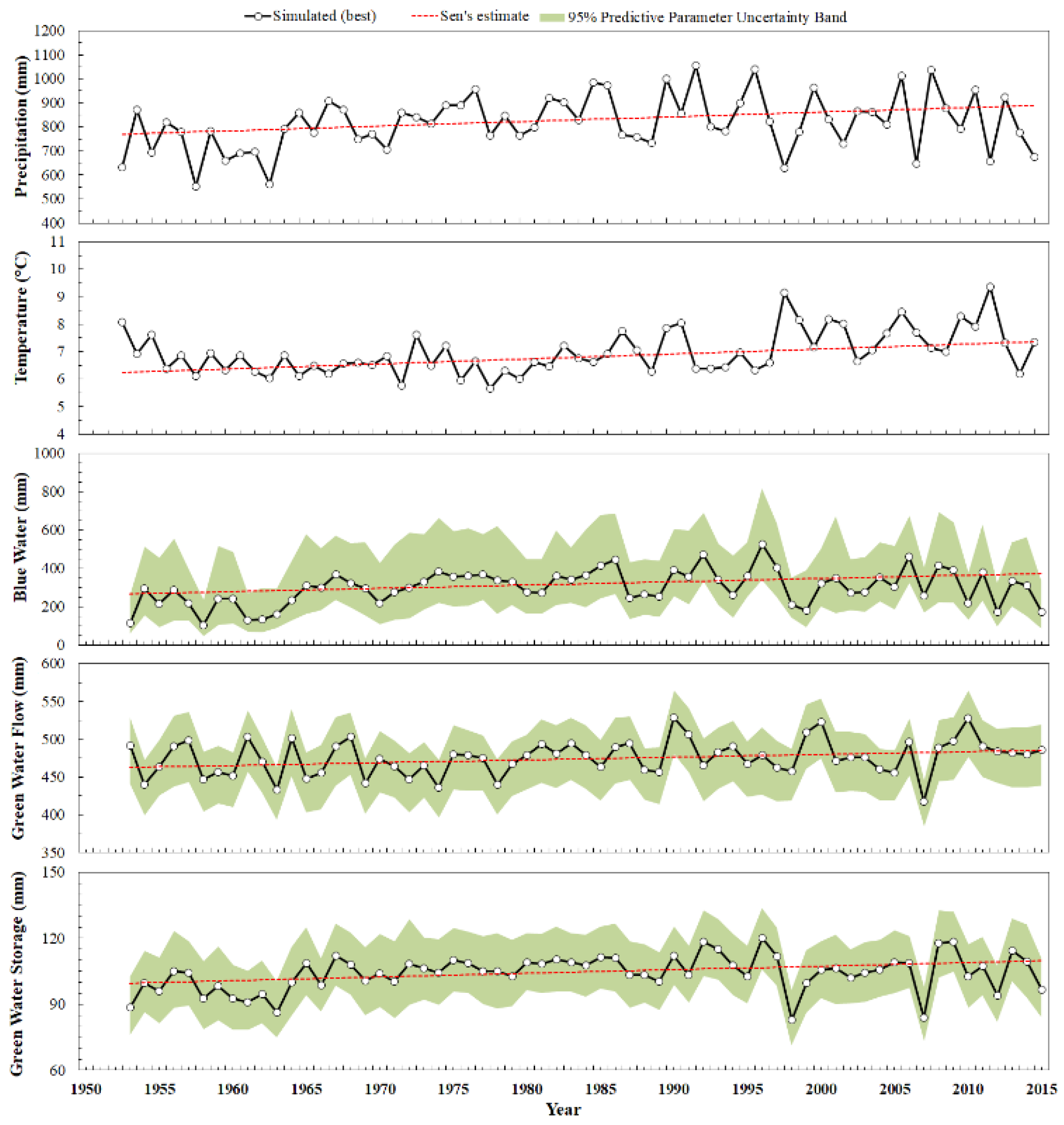
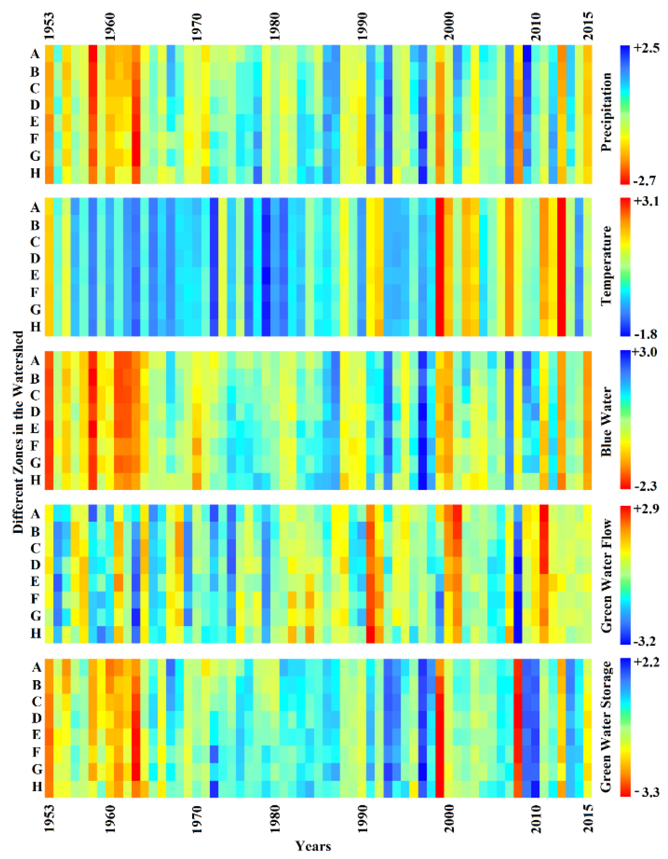
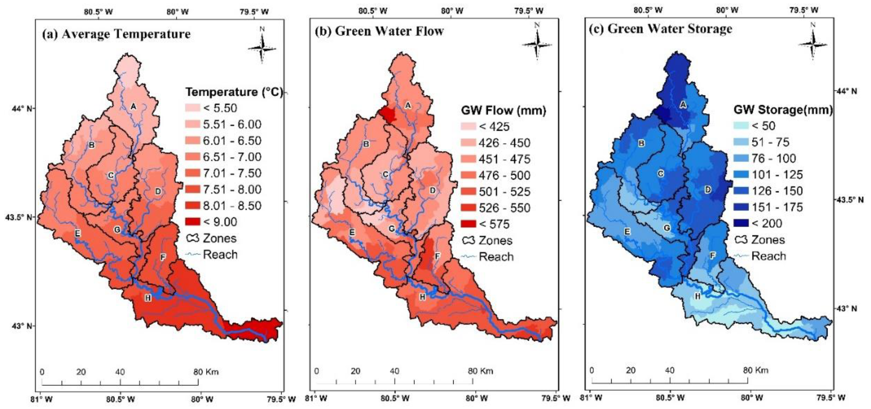
3.2. Spatiotemporal Variability of the Fresh Water Resources
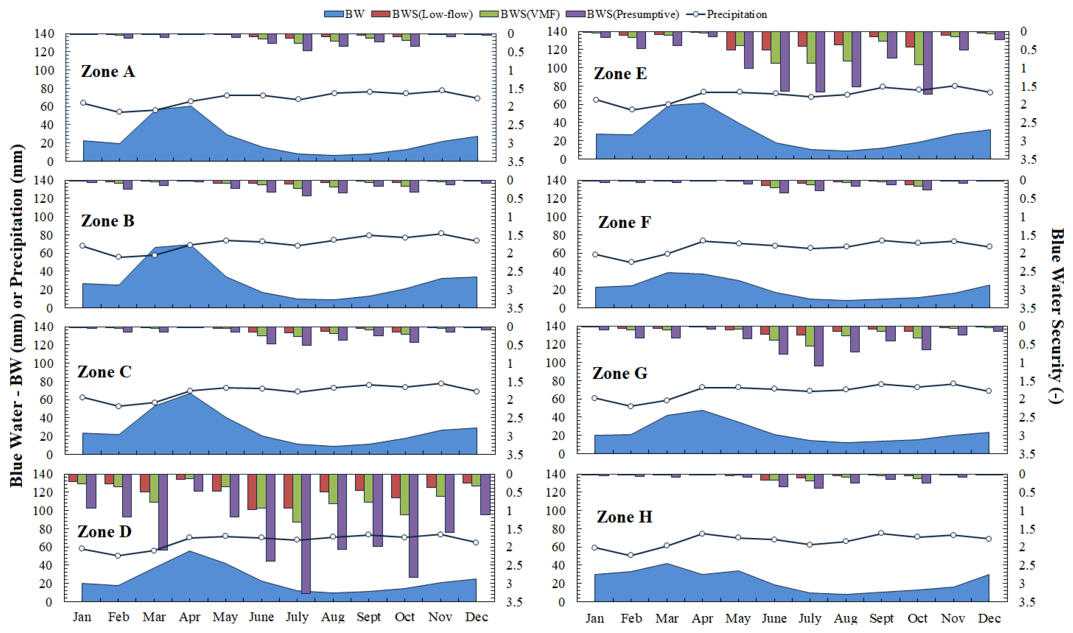
3.3. Blue Water Security Status Using Different EFR Methods
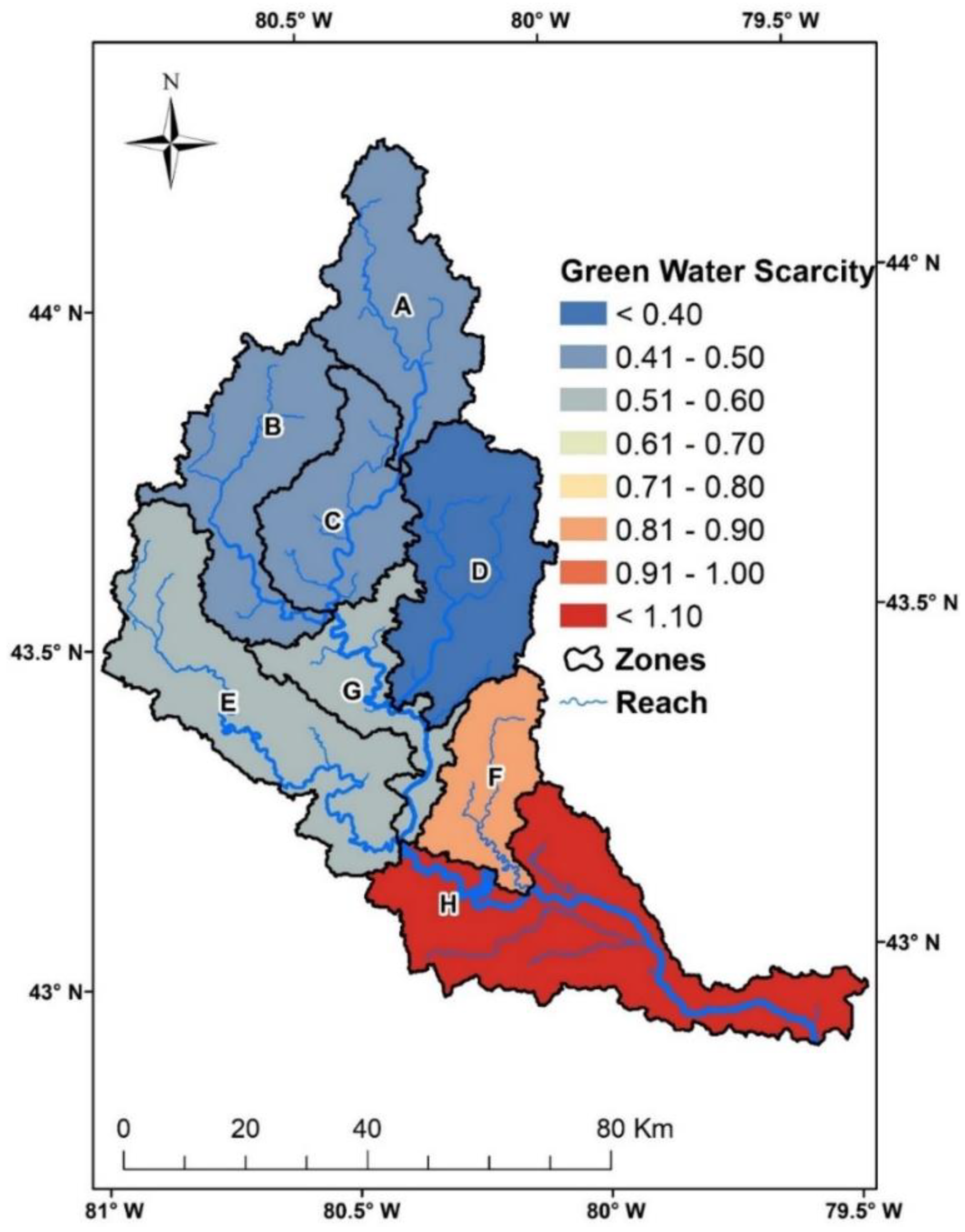
3.4. Green Water Security Status
4. Conclusions
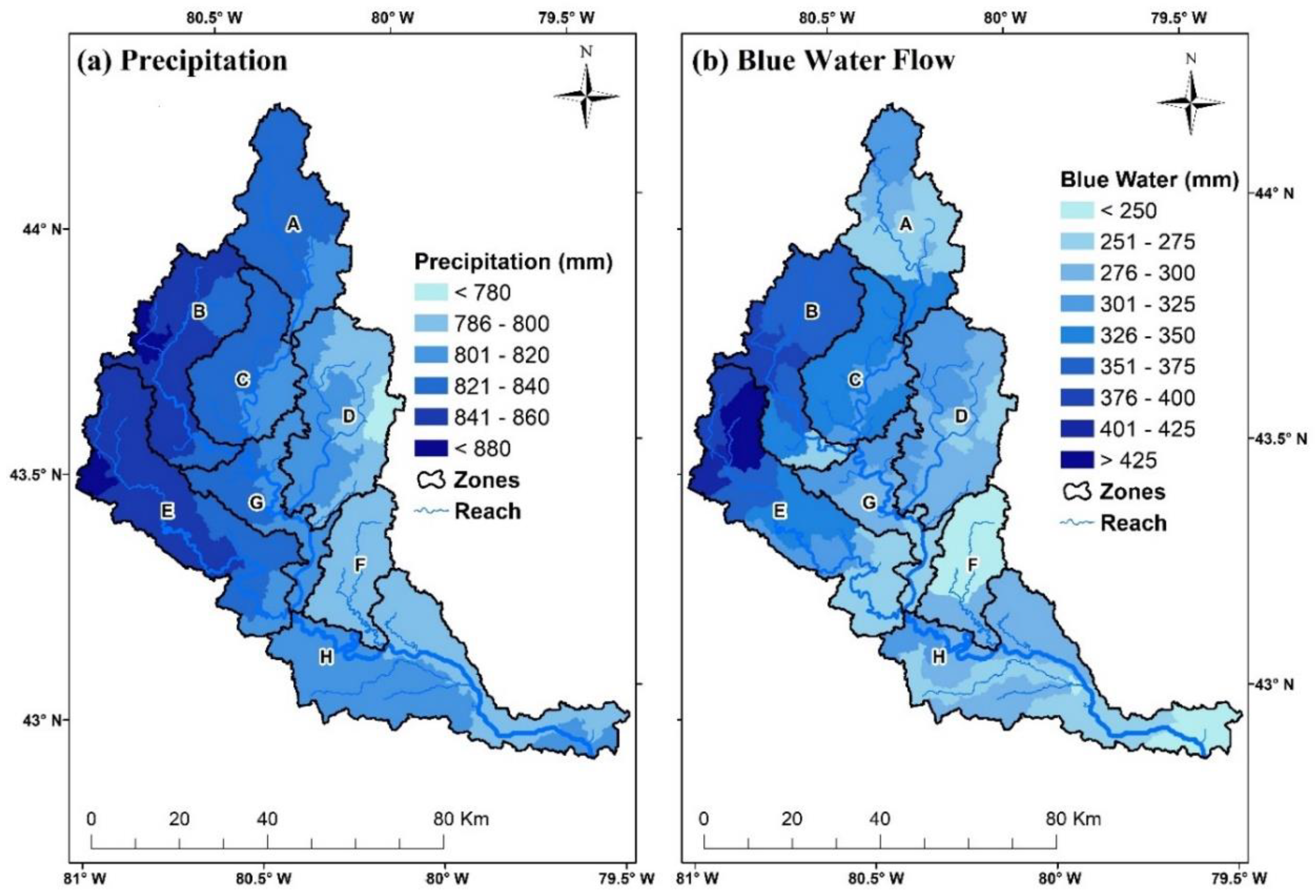
- Spatial and temporal variability in the blue water resources can be explained by variability in climate factors (i.e., precipitation). Long-term analyses showed that the western sub-basins of the GRW had the highest blue water resources.
- The green water flow, on the other hand, was found to be associated with temperature, precipitation, and land use/land cover. The higher the temperature and more intense the agriculture was, the higher the green water flow was, as was observed for southern sub-basins of the GRW. Green water storage was found to be associated with various soil properties and was seen to be influenced by elevation or depth of soil. Thereby, a higher green water storage in the northern part of the watershed was observed.
- Blue water security analysis showed contrasting results for different EFR methods used. The presumptive method was found to be the most restrictive and conservative when compared to others. The blue water was scarce in some regions of the GRW and was found to be severe in specific periods, especially for the Eramosa and Speed river sub-watershed and in summer months, on account of the higher percentage of urban area, more water use, and less blue water availability.
- Green water security analysis showed that the basin had no severe green water scarcity, and that it was adequate enough for practicing rain-fed agriculture in spring and fall seasons. It was found to be the highest in the southern Grand River sub-watershed because of the higher temperature, larger green water footprint, and lower green water availability.
Supplementary Materials
Author Contributions
Funding
Acknowledgments
Conflicts of Interest
References
- UN-Water. Water security & the global water agenda. In UN Water Analytical Brief; UN University: Hamilton, ON, Canada, 2013. [Google Scholar]
- Hoekstra, A.Y.; Mekonnen, M.M.; Chapagain, A.K.; Mathews, R.E.; Richter, B.D. Global monthly water scarcity: Blue water footprints versus blue water availability. PLoS ONE 2012, 7, e32688. [Google Scholar] [CrossRef] [PubMed]
- Abbaspour, K.C.; Rouholahnejad, E.; Vaghefi, S.; Srinivasan, R.; Yang, H.; Kløve, B. A continental-scale hydrology and water quality model for Europe: Calibration and uncertainty of a high-resolution large-scale SWAT model. J. Hydrol. 2015, 524, 733–752. [Google Scholar] [CrossRef]
- Veettil, A.V.; Mishra, A.K. Water security assessment using blue and green water footprint concepts. J. Hydrol. 2016, 542, 589–602. [Google Scholar] [CrossRef]
- WWAP. The United Nations World Water Development Report 4: Managing Water under Uncertainty and Risk; United Nations Educational, Scientific and Cultural Organization: Paris, France, 2012. [Google Scholar]
- WWAP. The United Nations World Water Development Report 2015: Water for a Sustainable World; United Nations Educational, Scientific and Cultural Organization: Paris, France, 2015. [Google Scholar]
- Faramarzi, M.; Abbaspour, K.C.; Lu, W.; Fennell, J.; Zehnder, A.J.B.; Goss, G.G. Uncertainty based assessment of dynamic freshwater scarcity in semi-arid watersheds of Alberta, Canada. J. Hydrol. Reg. Stud. 2017, 9, 48–68. [Google Scholar] [CrossRef]
- Rodrigues, D.B.B.; Gupta, H.V.; Mendiondo, E.M. A blue/green water-based accounting framework for assessment of water security. Water Resour. Res. 2014, 50, 7187–7205. [Google Scholar] [CrossRef]
- Aldaya, M.M.; Chapagain, A.K.; Hoekstra, A.Y.; Mekonnen, M.M. The Water Footprint Assessment Manual: Setting the Global Standard; Routledge: Abingdon-on-Thames, UK, 2012. [Google Scholar]
- Liu, J.; Zehnder, A.J.B.; Yang, H. Global consumptive water use for crop production: The importance of green water and virtual water. Water Resour. Res. 2009, 45. [Google Scholar] [CrossRef]
- Schuol, J.; Abbaspour, K.C.; Yang, H.; Srinivasan, R.; Zehnder, A.J.B. Modeling blue and green water availability in Africa. Water Resour. Res. 2008, 44. [Google Scholar] [CrossRef]
- Faramarzi, M.; Abbaspour, K.C.; Schulin, R.; Yang, H. Modelling blue and green water resources availability in Iran. Hydrol. Process. 2009, 23, 486–501. [Google Scholar] [CrossRef]
- Zang, C.F.; Liu, J.; van der Velde, M.; Kraxner, F. Assessment of spatial and temporal patterns of green and blue water flows under natural conditions in inland river basins in Northwest China. Hydrol. Earth Syst. Sci. 2012, 16, 2859–2870. [Google Scholar] [CrossRef]
- Abbaspour, K.C.; Faramarzi, M.; Ghasemi, S.S.; Yang, H. Assessing the impact of climate change on water resources in Iran. Water Resour. Res. 2009, 45, W10434–W10435. [Google Scholar] [CrossRef]
- Verzano, K. Climate Change Impacts on Flood Related Hydrological Processes: Further Development and Application of a Global Scale Hydrological Model. Ph.D. Thesis, University of Kassel, Kassel, Germany, 2009. [Google Scholar]
- Arnold, J.G.; Srinivasan, R.; Muttiah, R.S.; Williams, J.R. Large area hydrologic modeling and assessment part I: Model development 1. JAWRA J. Am. Water Resour. Assoc. 1998, 34, 73–89. [Google Scholar] [CrossRef]
- Allen, R.G.; Pereira, L.S.; Raes, D.; Smith, M. Crop evapotranspiration-Guidelines for computing crop water requirements-FAO Irrigation and drainage paper 56. FAORome 1998, 300, D05109. [Google Scholar]
- Heng, L.K.; Hsiao, T.; Evett, S.; Howell, T.; Steduto, P. Validating the FAO AquaCrop model for irrigated and water deficient field maize. Agron. J. 2009, 101, 488–498. [Google Scholar] [CrossRef]
- Pastor, A.V.; Ludwig, F.; Biemans, H.; Hoff, H.; Kabat, P. Accounting for environmental flow requirements in global water assessments. Hydrol. Earth Syst. Sci. 2014, 18, 5041–5059. [Google Scholar] [CrossRef]
- Dudgeon, D. Large-scale hydrological changes in tropical Asia: Prospects for riverine biodiversity. BioScience 2000, 50, 793–806. [Google Scholar] [CrossRef]
- Arnell, N.W. Climate change and global water resources: SRES emissions and socio-economic scenarios. Glob. Environ. Chang. 2004, 14, 31–52. [Google Scholar] [CrossRef]
- Rockström, J.; Falkenmark, M.; Karlberg, L.; Hoff, H.; Rost, S.; Gerten, D. Future water availability for global food production: The potential of green water for increasing resilience to global change. Water Resour. Res. 2009, 45, W00A12. [Google Scholar] [CrossRef]
- Hoff, H.; Falkenmark, M.; Gerten, D.; Gordon, L.; Karlberg, L.; Rockström, J. Greening the global water system. J. Hydrol. 2010, 384, 177–186. [Google Scholar] [CrossRef]
- Gleeson, T.; Wada, Y.; Bierkens, M.F.P.; van Beek, L.P.H. Water balance of global aquifers revealed by groundwater footprint. Nature 2012, 488, 197. [Google Scholar] [CrossRef] [PubMed]
- Hoekstra, A.Y.; Mekonnen, M.M. The Monthly Blue Water Footprint Compared to Blue Water Availabillity for the Worlds Major River Basins; Unesco-Ihe: Delft, The Netherlands, 2011. [Google Scholar]
- Smakhtin, V.; Revenga, C.; Döll, P. A pilot global assessment of environmental water requirements and scarcity. Water Int. 2004, 29, 307–317. [Google Scholar] [CrossRef]
- Tate, D.M. Water Use and Demand Forecasting in Canada: A Review; IIASA Research Memorandum; IIASA: Laxenburg; Vienna, Austria, 1978; Volume RM-78-016. [Google Scholar]
- NRCAN Water. Natural Resources Canada. Available online: https://www.nrcan.gc.ca/earth-sciences/geography/atlas-canada/selected-thematic-maps/16888 (accessed on 1 September 2018).
- WMP. Grand River Watershed Water Management Plan; Grand River Conservation Authority: Cambridge, ON, Canada, 2014; p. 137. [Google Scholar]
- Wong, A.; Boyd, D. Environmental Flow Requirements in the Grand River Watershed; Grand River Conservation Authority: Cambridgec, ON, Canada, 2014; pp. 1–2. [Google Scholar]
- Jyrkama, M.I.; Sykes, J.F. The impact of climate change on spatially varying groundwater recharge in the grand river watershed (Ontario). J. Hydrol. 2007, 338, 237–250. [Google Scholar] [CrossRef]
- Zhang, B.; Shrestha, N.; Daggupati, P.; Rudra, R.; Shukla, R.; Kaur, B.; Hou, J. Quantifying the Impacts of Climate Change on Streamflow Dynamics of Two Major Rivers of the Northern Lake Erie Basin in Canada. Sustainability 2018, 10, 2897. [Google Scholar] [CrossRef]
- NRCAN. Natural Resources Canada. Available online: https://www.nrcan.gc.ca (accessed on 1 August 2018).
- GRCA. Grand River Watershed Characterization Report; Grand River Conservation Authority: Cambridge, ON, Canada, 2008. [Google Scholar]
- Shum, D. State of Emergency Declared in Brantford, Ont., Due to Flooding. Available online: https://globalnews.ca/news/4037567/brantford-evacuation-flood-risk/ (accessed on 1 October 2018).
- Liu, Y.; Yang, W.; Leon, L.; Wong, I.; McCrimmon, C.; Dove, A.; Fong, P. Hydrologic modeling and evaluation of Best Management Practice scenarios for the Grand River watershed in Southern Ontario. J. Great Lakes Res. 2016, 42, 1289–1301. [Google Scholar] [CrossRef]
- Shrestha, N.K.; Wang, J. Predicting sediment yield and transport dynamics of a cold climate region watershed in changing climate. Sci. Total Environ. 2018, 625, 1030–1045. [Google Scholar] [CrossRef] [PubMed]
- Grusson, Y.; Sun, X.; Gascoin, S.; Sauvage, S.; Raghavan, S.; Anctil, F.; Sáchez-Pérez, J.-M. Assessing the capability of the SWAT model to simulate snow, snow melt and streamflow dynamics over an alpine watershed. J. Hydrol. 2015, 531, 574–588. [Google Scholar] [CrossRef]
- Arnold, J.G.; Moriasi, D.N.; Gassman, P.W.; Abbaspour, K.C.; White, M.J.; Srinivasan, R.; Santhi, C.; Harmel, R.D.; van Griensven, A.; Van Liew, M.W.; et al. SWAT: Model use, calibration, and validation. Am. Soc. Agric. Biol. Eng. 2012, 55, 18. [Google Scholar]
- OMNRF. Provincial Digital Elevation Model, 3rd ed.; Ministry of Natural Resources and Forestry: Petersburg, ON, Canada, 2015. [Google Scholar]
- Srinivasan, R.; Zhang, X.; Arnold, J. SWAT Ungauged: Hydrological Budget and Crop Yield Predictions in the Upper Mississippi River Basin. Trans. Asabe 2010, 53, 1533–1546. [Google Scholar] [CrossRef]
- Daggupati, P.; Deb, D.; Srinivasan, R.; Yeganantham, D.; Mehta, V.M.; Rosenberg, N.J. Large-scale fine-resolution hydrological modeling using parameter regionalization in the Missouri River Basin. JAWRA J. Am. Water Resour. Assoc. 2016, 52, 648–666. [Google Scholar] [CrossRef]
- Hargreaves, G.L.; Hargreaves, G.H.; Riley, J.P. Agricultural benefits for Senegal River basin. J. Irrig. Drain. Eng. 1985, 111, 113–124. [Google Scholar] [CrossRef]
- Daggupati, P.; Yen, H.; White, M.J.; Srinivasan, R.; Arnold, J.G.; Keitzer, C.S.; Sowa, S.P. Impact of model development, calibration and validation decisions on hydrological simulations in West Lake Erie Basin. Hydrol. Process. 2015, 29, 5307–5320. [Google Scholar] [CrossRef]
- Abbaspour, K.C.; Johnson, C.A.; van Genuchten, M.T. Estimating uncertain flow and transport parameters using a sequential uncertainty fitting procedure. Vadose Zone J. 2004, 3, 1340–1352. [Google Scholar] [CrossRef]
- Moriasi, D.N.; Gitau, M.W.; Pai, N.; Daggupati, P. Hydrologic and water quality models: Performance measures and evaluation criteria. Trans. Asabe 2015, 58, 1763–1785. [Google Scholar]
- Sen, P.K. Estimates of the Regression Coefficient Based on Kendall’s Tau. J. Am. Stat. Assoc. 1968, 63, 1379–1389. [Google Scholar] [CrossRef]
- Wong, A. Water Use Inventory Report for the Grand River Watershed; Grand River Conservation Authority: Cambridge, ON, Canada, 2011. [Google Scholar]
- Richter, B.D.; Davis, M.M.; Apse, C.; Konrad, C. A presumptive standard for environmental flow protection. River Res. Appl. 2012, 28, 1312–1321. [Google Scholar] [CrossRef]
- Reilly, C.F.; Kroll, C.N. Estimation of 7-day, 10-year low-streamflow statistics using baseflow correlation. Water Resour. Res. 2003, 39, 1740. [Google Scholar] [CrossRef]
- Chow, V.T.; Maidment, D.R.; Mays, L.W. Applied Hydrology; McGraw-Hill: New York, NY, USA, 1988. [Google Scholar]
- Logsdon, R.A.; Chaubey, I. A quantitative approach to evaluating ecosystem services. Ecol. Model. 2013, 257, 57–65. [Google Scholar] [CrossRef]
- Shrestha, N.K.; Du, X.; Wang, J. Assessing climate change impacts on fresh water resources of the Athabasca River Basin, Canada. Sci. Total Environ. 2017, 601–602, 425–440. [Google Scholar] [CrossRef]
- Troin, M.; Caya, D. Evaluating the SWAT’s snow hydrology over a Northern Quebec watershed. Hydrol. Process. 2014, 28, 1858–1873. [Google Scholar] [CrossRef]
- Faramarzi, M.; Srinivasan, R.; Iravani, M.; Bladon, K.D.; Abbaspour, K.C.; Zehnder, A.J.B.; Goss, G.G. Setting up a hydrological model of Alberta: Data discrimination analyses prior to calibration. Environ. Model. Softw. 2015, 74, 48–65. [Google Scholar] [CrossRef]
- Ahl, R.S.; Woods, S.W.; Zuuring, H.R. Hydrologic calibration and validation of swat in a snow-dominated rocky mountain watershed, montana, USA 1. JAWRA J. Am. Water Resour. Assoc. 2008, 44, 1411–1430. [Google Scholar] [CrossRef]




| Data | Source | Resolution |
|---|---|---|
| Topography (Digital Elevation Model—DEM) | Ontario Ministry of Natural Resources and Forestry (OMAFRA) | 30 × 30 m |
| Soil | Soil Landscapes of Canada (SLC), version 3.2 | 1:1 million |
| Land use | Agriculture and Agri-Food, Canada (AAFC) | 30 × 30 m |
| Crop management | Agriculture and Agri-Food, Canada | 30 × 30 m |
| Tile drainage | Ontario Ministry of Agriculture, Food and Rural Affairs (OMAFRA) | 30 × 30 m |
| Precipitation | Natural Resources Canada (NRCAN, 2018) | Daily (mm) |
| Maximum and Minimum Temperature | Natural Resources Canada (NRCAN, 2018) | Daily (°C) |
| Sensitive Parameters | Description | Default | Minimum | Maximum |
|---|---|---|---|---|
| r_CN2.mgt | SCS curve number for moisture condition II (-) | HRU * | −10% | 15% |
| v_ALPHA_BF.gw | Baseflow recession constant (-) | 0.048 | 0.4 | 0.7 |
| v_GW_DELAY.gw | Groundwater delay time (days) | 31 | 10 | 100 |
| v_SFTMP.bsn | Snowfall temperature (°C) | 1 | −3 | 1 |
| v_SMTMP.bsn | Snowmelt base temperature (°C) | 0.5 | 0 | 5 |
| v_ESCO.bsn | Soil evaporation compensation factor (-) | 0.95 | 0.9 | 1 |
| v_EPCO.bsn | Soil uptake compensation factor (-) | 1 | 0.7 | 1 |
| v_GWQMN.gw | Threshold depth of water in shallow aquifer required for return flow to occur (mm) | 1000 | 500 | 1500 |
| v_GW_REVAP.gw | Groundwater revap. Coefficient (-) | 0.02 | 0.1 | 0.2 |
| v_REVAPMN.gw | Threshold depth of water in shallow aquifer for revap to deep aquifer to occur (mm) | 750 | 650 | 850 |
| r_SOL_K.sol | Soil hydraulic conductivity (mm/h) | soil type ** | −10% | 10% |
| r_SOL_AWC.sol | Available water capacity of soil layer (mm/mm) | soil type ** | −10% | 10% |
| v_CH_N2.rte | Manning’s n value for the main channel (-) | 0.14 | 0.03 | 0.2 |
| v_CH_K2.rte | Effective hydraulic conductivity in main channel alluvium (mm/h) | 0 | 10 | 100 |
| v_ALPHA_BNK.rte | Baseflow alpha factor for bank storage (days) | 0 | 0.2 | 0.6 |
| v_TIMP.bsn | Snow pack temperature lag factor (-) | 1 | 0.5 | 1 |
| v_SMFMX.bsn | Melt factor of snow on June 21 (mm H2O/°C-day) | 4.5 | 2 | 6 |
| * depends on the HRU,hydrological response unit (HRU), ** depends on the soil type | ||||
| r_: relative change with the value with respect to the original (default) value | ||||
| v_: replaced by the given value | ||||
| Flow Station | Calibration Results | Validation Results | ||||||||
|---|---|---|---|---|---|---|---|---|---|---|
| p-Factor | r-Factor | Nash–Sutcliffe Efficiency (NSE) | R2 | Percent Bias (PBIAS) (%) | p-Factor | r-Factor | NSE | R2 | PBIAS (%) | |
| Grand at Marshville | 0.83 | 0.81 | 0.82 (G) | 0.83 (G) | 8.60 (G) | 0.71 | 0.67 | 0.83 (G) | 0.86 (V) | 19.8 (U) |
| Eramosa at Guelph | 0.85 | 1.33 | 0.66 (U) | 0.68 (U) | 0.40 (V) | 0.77 | 1.2 | 0.69 (U) | 0.79 (S) | 9.30 (G) |
| Grand at Brantford | 0.81 | 0.99 | 0.83 (G) | 0.85 (V) | 11.4 (S) | 0.91 | 1.14 | 0.8 (G) | 0.86 (V) | 18.8 (U) |
| McKenzie at Caledonia | 0.84 | 0.99 | 0.74 (S) | 0.74 (S) | 1.60 (V) | 0.88 | 0.96 | 0.57 (U) | 0.62 (U) | 18.1 (U) |
| Fairchild at Brantford | 0.87 | 0.99 | 0.76 (S) | 0.76 (S) | −0.80 (V) | 0.76 | 0.88 | 0.63 (U) | 0.67 (U) | 3.40 (G) |
| Nith at Canning | 0.93 | 1.24 | 0.87 (V) | 0.87 (V) | 5.90 (G) | 0.83 | 0.98 | 0.81 (G) | 0.82 (G) | 2.30 (V) |
© 2019 by the authors. Licensee MDPI, Basel, Switzerland. This article is an open access article distributed under the terms and conditions of the Creative Commons Attribution (CC BY) license (http://creativecommons.org/licenses/by/4.0/).
Share and Cite
Kaur, B.; Shrestha, N.K.; Daggupati, P.; Rudra, R.P.; Goel, P.K.; Shukla, R.; Allataifeh, N. Water Security Assessment of the Grand River Watershed in Southwestern Ontario, Canada. Sustainability 2019, 11, 1883. https://doi.org/10.3390/su11071883
Kaur B, Shrestha NK, Daggupati P, Rudra RP, Goel PK, Shukla R, Allataifeh N. Water Security Assessment of the Grand River Watershed in Southwestern Ontario, Canada. Sustainability. 2019; 11(7):1883. https://doi.org/10.3390/su11071883
Chicago/Turabian StyleKaur, Baljeet, Narayan Kumar Shrestha, Prasad Daggupati, Ramesh Pal Rudra, Pradeep Kumar Goel, Rituraj Shukla, and Nabil Allataifeh. 2019. "Water Security Assessment of the Grand River Watershed in Southwestern Ontario, Canada" Sustainability 11, no. 7: 1883. https://doi.org/10.3390/su11071883
APA StyleKaur, B., Shrestha, N. K., Daggupati, P., Rudra, R. P., Goel, P. K., Shukla, R., & Allataifeh, N. (2019). Water Security Assessment of the Grand River Watershed in Southwestern Ontario, Canada. Sustainability, 11(7), 1883. https://doi.org/10.3390/su11071883


