Developing a Framework for the Implementation of Landscape and Greenspace Indicators in Sustainable Urban Planning. Waterfront Landscape Management: Case Studies in Gdańsk, Poznań and Bristol


Abstract
1. Introduction
- to select and compare ecological, visual and structural LGI relevant for urban areas based on a literature study;
- to identify the existing provisions in the Polish spatial planning system, intended for UL and UG management and preservation, based on planning documents for waterfront areas in Gdańsk and Poznań;
- to tentativelyindicate the applicability of the selected LGI in the planning and spatial management of urban and metropolitan areas in Poland at different spatial planning levels;
- to compare the policies for the development of waterfront areas within the process of urban planning based on three selected case studies in Bristol, Gdańsk and Poznań.
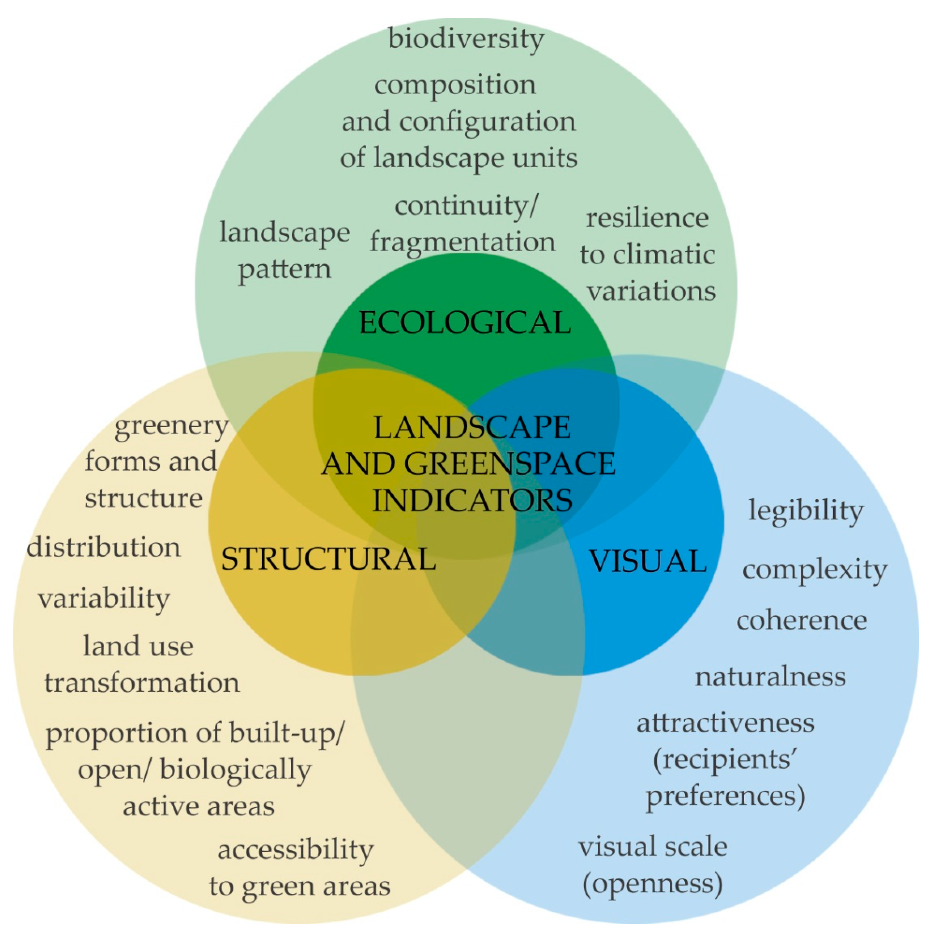
2. Conceptual Framework—LGI in Relation to Urban Areas
2.1. Ecological Indicators
2.2. Structural Indicators
2.3. Visual Indicators
2.4. Integrating LGI
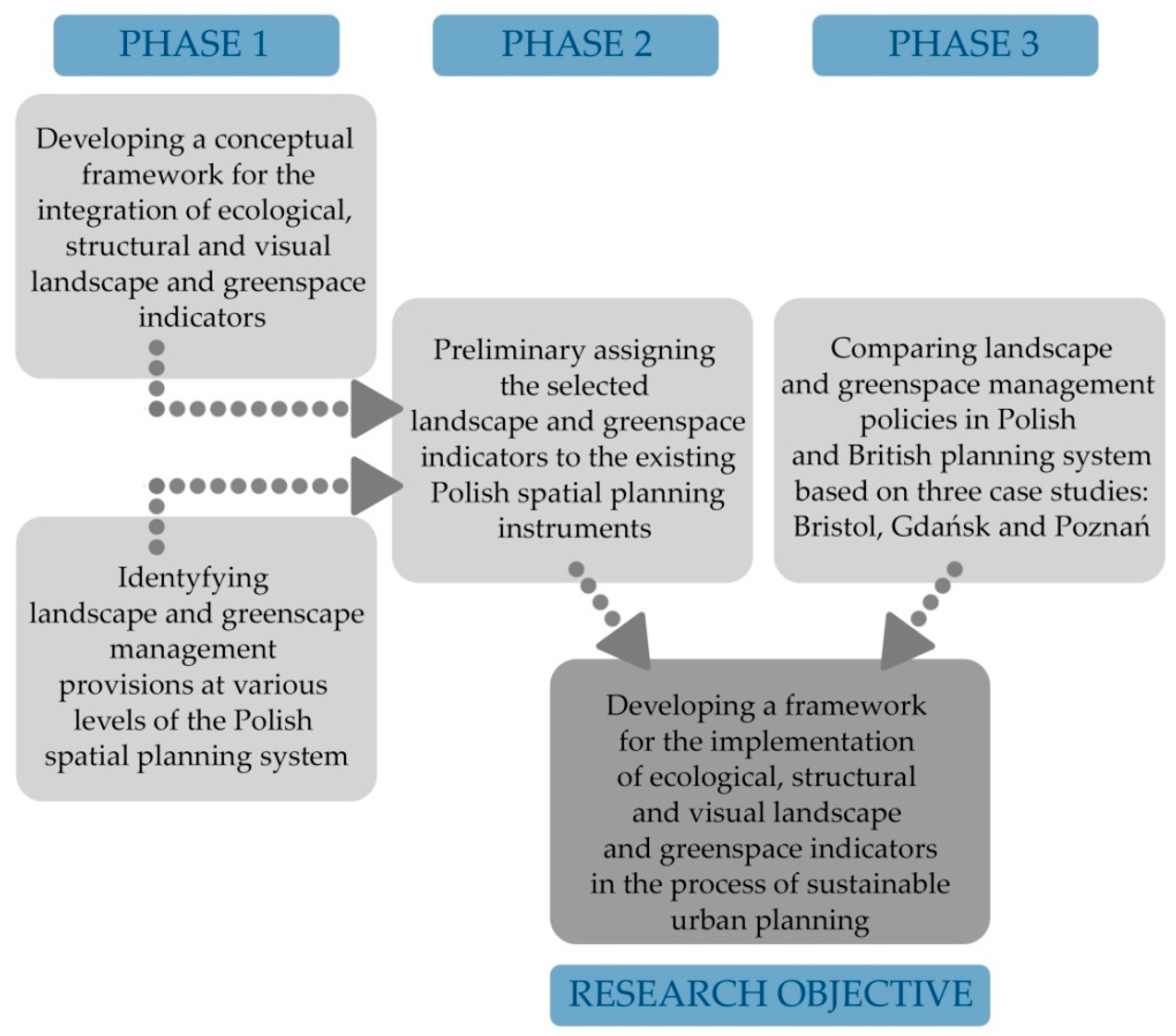
3. Materials and Methods
3.1. Research Methods
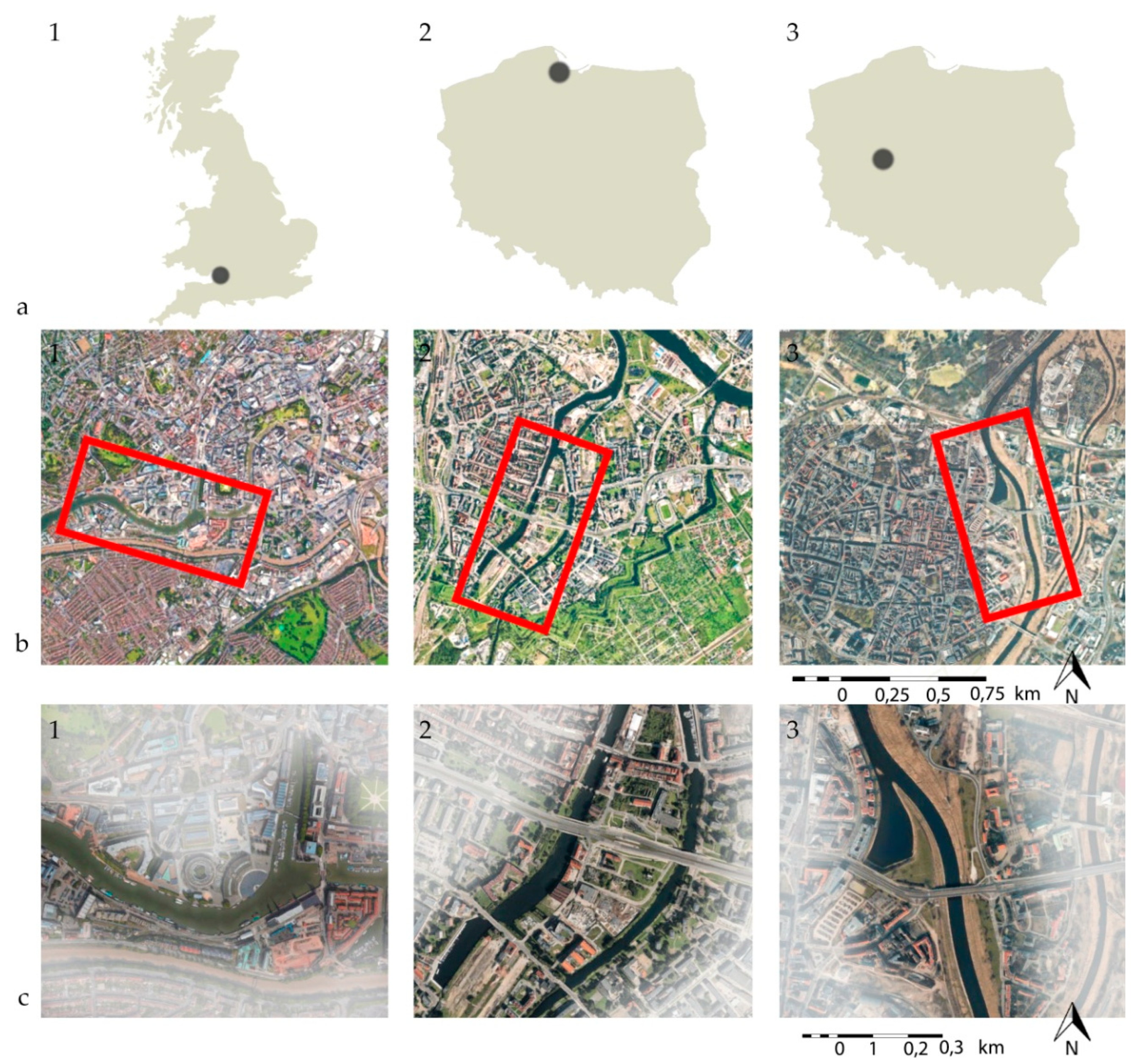
3.2. Study Areas
4. Results and Discussion
4.1. Applicability of LGI in the Polish Spatial Planning System with Regard to English Experiences
4.2. Visual, Ecological and Structural Quality of Urban Riverside Landscape—Case Studies
5. Conclusions
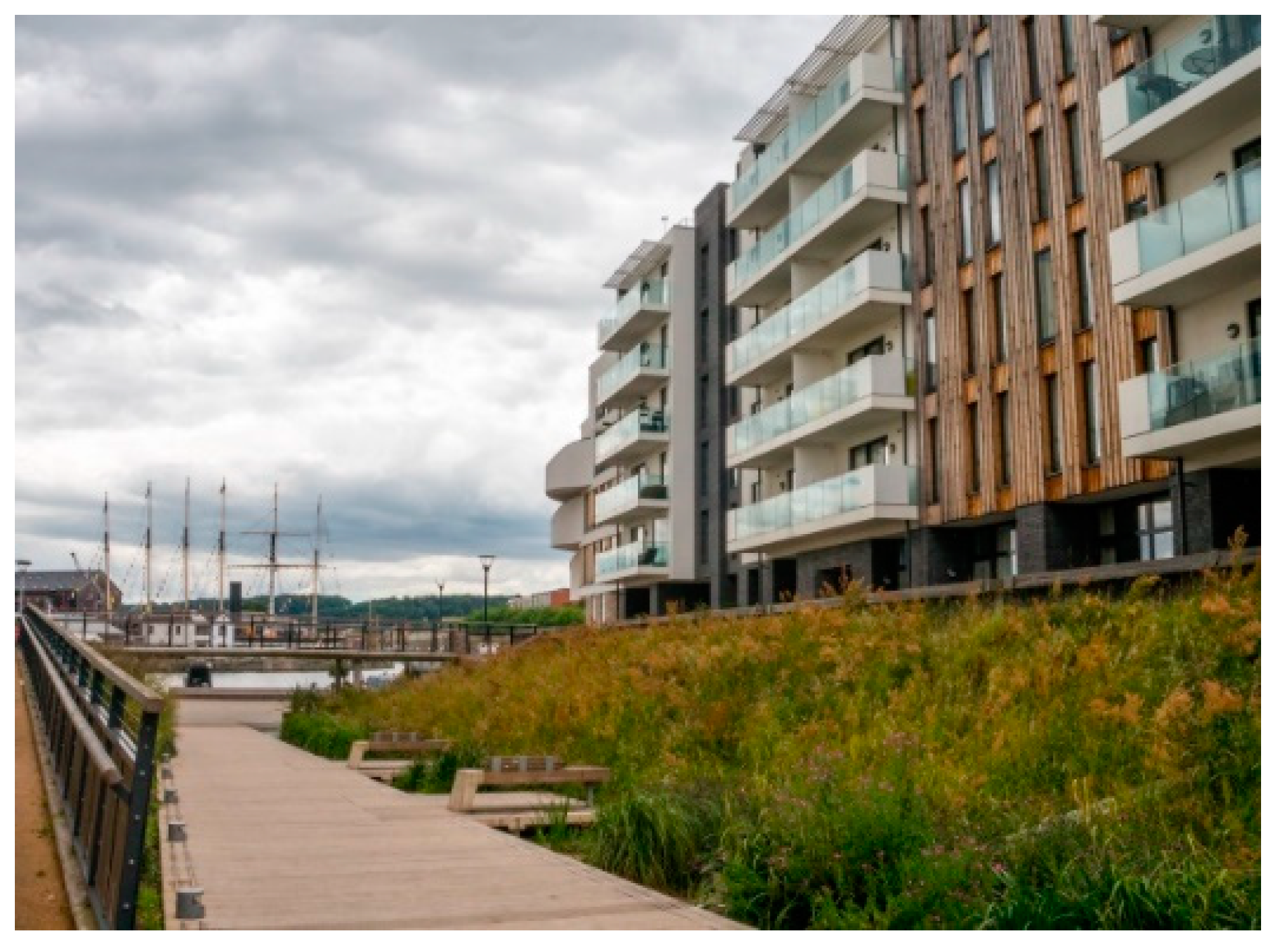
- The regeneration of the river Avon waterfront in Bristol was based on a coherent landscape plan. The included pro-ecological and landscape-beneficial solutions were preceded by visual and compositional analysis. In result, the transformed urban space is characterized by high visual value and biodiversity and it is fully accessible to the residents.
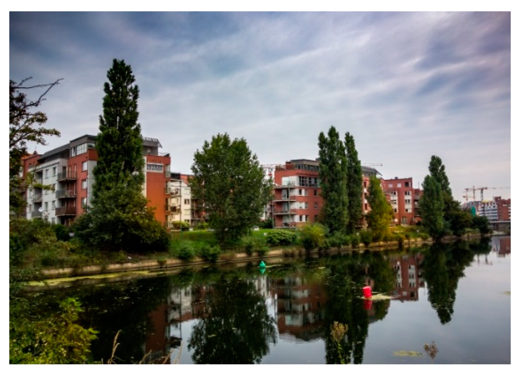
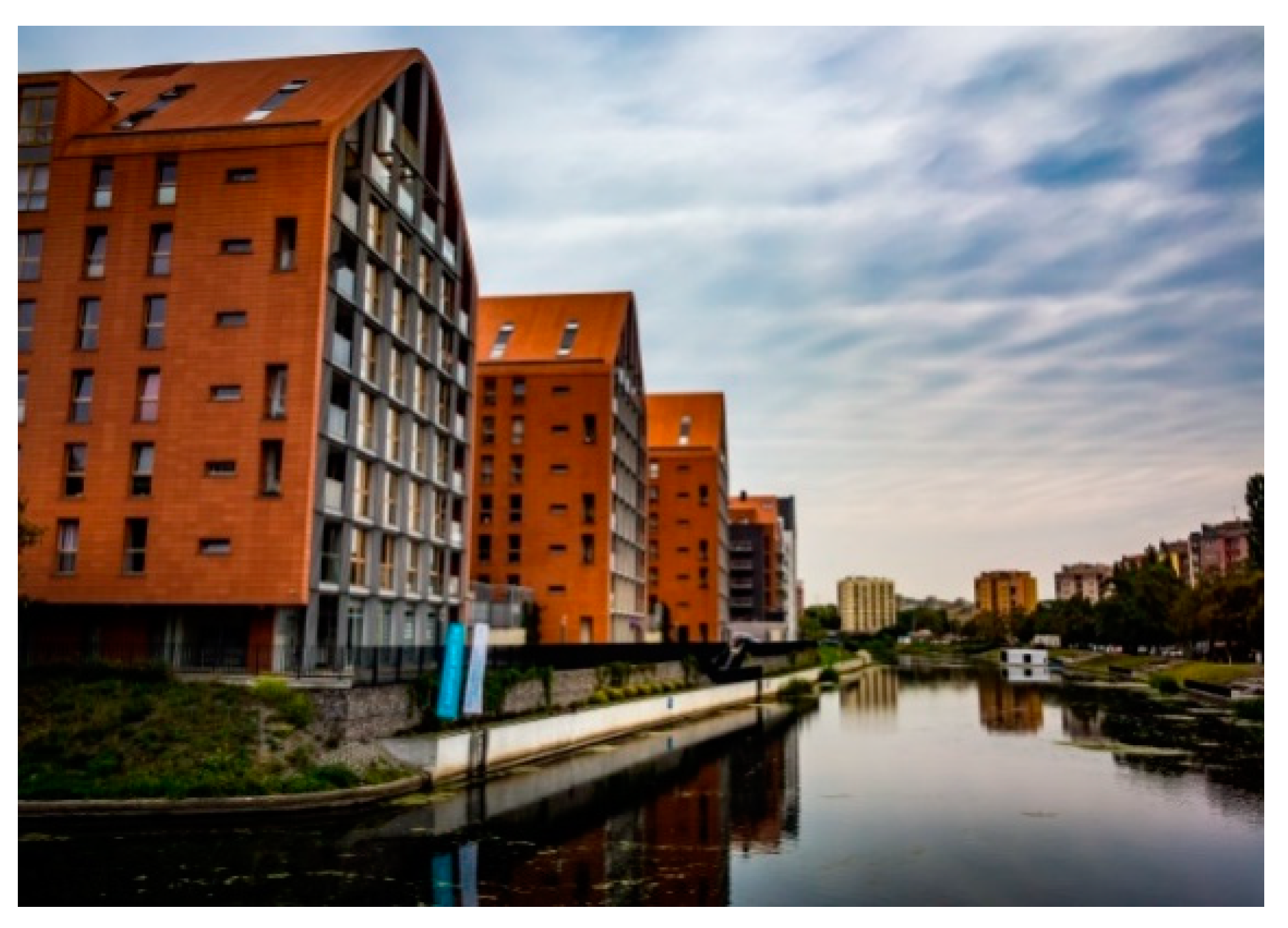
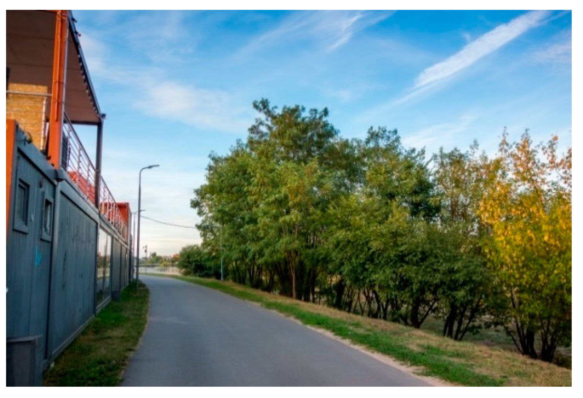
- In case of the Motława Channel waterfront in Gdańsk, there was no overall landscape project, although the protection of the continuity and consistency of landscape is advocated in the SCSDDM. Due to several LSDP for the area, the landscape is becoming increasingly fragmented and the continuity of the natural structures is interrupted. The waterfront is densely built-up, the proportion of green areas and their accessibility are relatively low and there are limited visual connections.
- The area of Warta river valley in Poznań is covered by a regeneration program which is aimed at the restoration of the ecological and compositional continuity and the improvement of the waterfront accessibility. However, this is a conceptual project, so the development of the waterfront is still based on several LSDP. The accessibility of the waterfront is relatively high (except some built-up zones), yet, the degree of biodiversity is quite low. Due to the lack of visual analysis, there are some limitations in the visual connections.
Author Contributions
Funding
Conflicts of Interest
References
- Yigitcanlar, T.; Teriman, S. Rethinking sustainable urban development: towards an integrated planning and development process. Int. J. Environ. Sci. Technol. 2015, 12, 341–352. [Google Scholar] [CrossRef]
- Ioppolo, G.; Cucurachi, S.; Salomone, R.; Saija, G.; Shi, L. Sustainable Local Development and Environmental Governance: A Strategic Planning Experience. Sustainability 2016, 8, 180. [Google Scholar] [CrossRef]
- Alberti, M.; Waddell, P. An integrated urban development and ecological simulation model. Integr. Assess. 2000, 1, 215–227. [Google Scholar] [CrossRef]
- Hostetler, M.; Allen, W.; Meurk, C. Conserving urban biodiversity? Creating green infrastructure is only the first step. Landsc. Urban Plan. 2011, 100, 369–371. [Google Scholar] [CrossRef]
- Grêt-Regamey, A.; Altwegg, J.; Sirén, E.A.; van Strien, M.J.; Weibel, B. Integrating ecosystem services into spatial planning—A spatial decision support tool. Landsc. Urban Plan. 2017, 165, 206–219. [Google Scholar] [CrossRef]
- Abraham, A.; Sommerhalder, K.; Abel, T. Landscape and well-being: A scoping study on the health-promoting impact of outdoor environments. Int. J. Public Health 2010, 55, 59–69. [Google Scholar] [CrossRef]
- Velarde, M.D.; Fry, G.; Tveit, M. Health effects of viewing landscapes—Landscape types in environmental psychology. Urban For. Urban Green. 2007, 6, 199–212. [Google Scholar] [CrossRef]
- Wolch, J.R.; Byrne, J.; Newell, J.P. Urban green space, public health, and environmental justice: The challenge of making cities “just green enough”. Landsc. Urban Plan. 2014, 125, 234–244. [Google Scholar] [CrossRef]
- Tzoulas, K.; Korpela, K.; Venn, S.; Yli-Pelkonen, V.; Kaźmierczak, A.; Niemela, J.; James, P. Promoting ecosystem and human health in urban areas using Green Infrastructure: A literature review. Landsc. Urban Plan. 2007, 81, 167–178. [Google Scholar] [CrossRef]
- Gavrilidis, A.A.; Ciocănea, C.M.; Niţă, M.R.; Onose, D.A.; Năstase, I.I. Urban Landscape Quality Index—Planning Tool for Evaluating Urban Landscapes and Improving the Quality of Life. Procedia Environ. Sci. 2016, 32, 155–167. [Google Scholar] [CrossRef]
- Kowarik, I. Novel urban ecosystems, biodiversity, and conservation. Environ. Pollut. 2011, 159, 1974–1983. [Google Scholar] [CrossRef]
- Loures, L. Post-industrial landscapes as drivers for urban redevelopment: Public versus expert perspectives towards the benefits and barriers of the reuse of post-industrial sites in urban areas. Habitat Int. 2015, 45, 72–81. [Google Scholar] [CrossRef]
- Runhaar, H.; Driessen, P.P.J.; Soer, L. Sustainable urban development and the challenge of policy integration: An assessment of planning tools for integrating spatial and environmental planning in the Netherlands. Environ. Plan. B Plan. Des. 2009, 36, 417–431. [Google Scholar] [CrossRef]
- Ahern, J. Urban landscape sustainability and resilience: The promise and challenges of integrating ecology with urban planning and design. Landsc. Ecol. 2013, 28, 1203–1212. [Google Scholar] [CrossRef]
- Badach, J.; Kolasińska, P.; Paciorek, M.; Wojnowski, W.; Dymerski, T.; Gębicki, J.; Dymnicka, M.; Namieśnik, J. A case study of odour nuisance evaluation in the context of integrated urban planning. J. Environ. Manag. 2018, 213, 417–424. [Google Scholar] [CrossRef]
- Raszeja, E.; Badach, J. Urban space recovery. Landscape-beneficial solutions in new estates built in post-industrial and post-military areas in Bristol, Poznań and Gdańsk. Misc. Geogr. 2018, 22, 210–218. [Google Scholar] [CrossRef]
- Steiner, F. Landscape ecological urbanism: Origins and trajectories. Landsc. Urban Plan. 2011, 100, 333–337. [Google Scholar] [CrossRef]
- Tress, G.; Tress, B.; Fry, G. Analysis of the barriers to integration in landscape research projects. Land use policy 2007, 24, 374–385. [Google Scholar] [CrossRef]
- Bürgi, M.; Ali, P.; Chowdhury, A.; Heinimann, A.; Hett, C.; Kienast, F.; Mondal, M.K.; Upreti, B.R.; Verburg, P.H. Integrated Landscape Approach: Closing the Gap between Theory and Application. Sustainability 2017, 9, 1371. [Google Scholar] [CrossRef]
- Hiremath, R.B.; Balachandra, P.; Kumar, B.; Bansode, S.S.; Murali, J. Indicator-based urban sustainability-A review. Energy Sustain. Dev. 2013, 17, 555–563. [Google Scholar] [CrossRef]
- Lowry, J.H.; Lowry, M.B. Comparing spatial metrics that quantify urban form. Comput. Environ. Urban Syst. 2014, 44, 59–67. [Google Scholar] [CrossRef]
- Vanderhaegen, S.; Canters, F. Mapping urban form and function at city block level using spatial metrics. Landsc. Urban Plan. 2017, 167, 399–409. [Google Scholar] [CrossRef]
- Liu, M.; Hu, Y.M.; Li, C.L. Landscape metrics for three-dimensional urban building pattern recognition. Appl. Geogr. 2017, 87, 66–72. [Google Scholar] [CrossRef]
- Zhao, C.; Fu, G.; Liu, X.; Fu, F. Urban planning indicators, morphology and climate indicators: A case study for a north-south transect of Beijing, China. Build. Environ. 2011, 46, 1174–1183. [Google Scholar] [CrossRef]
- Fry, G.; Tveit, M.S.; Ode, A.; Velaverde, M.D. The ecology of visual landscapes: Exploring the conceptual common ground of visual and ecological landscape indicators. Ecol. Indic. 2009, 9, 933–947. [Google Scholar] [CrossRef]
- Llausàs, A.; Nogué, J. Indicators of landscape fragmentation: The case for combining ecological indices and the perceptive approach. Ecol. Indic. 2012, 15, 85–91. [Google Scholar] [CrossRef]
- Antrop, M. From holistic landscape synthesis to transdisciplinary landscape management. In From Landscape Research to Landscape Planning: Aspects of Integration, Education and Application; Tress, B., Tress, G., Fry, G., Opdam, P., Eds.; Springer: Dordrecht, The Netherlands, 2005; pp. 27–50. [Google Scholar]
- Botequilha Leitão, A.; Ahern, J. Applying landscape ecological concepts and metrics in sustainable landscape planning. Landsc. Urban Plan. 2002, 59, 65–93. [Google Scholar] [CrossRef]
- Wang, R.; Zhao, J.; Liu, Z. Consensus in visual preferences: The effects of aesthetic quality and landscape types. Urban For. Urban Green. 2016, 20, 210–217. [Google Scholar] [CrossRef]
- Uuemaa, E.; Mander, Ü.; Marja, R. Trends in the use of landscape spatial metrics as landscape indicators: A review. Ecol. Indic. 2013, 28, 100–106. [Google Scholar] [CrossRef]
- Uuemaa, E.; Antrop, M.; Roosaare, J.; Marja, R.; Mander, Ü. Landscape Metrics and Indices: An Overview of Their Use in Landscape Research. Living Rev. Landsc. Res. 2009, 3, 1–28. [Google Scholar] [CrossRef]
- Aguilera, F.; Valenzuela, L.M.; Botequilha-Leitão, A. Landscape metrics in the analysis of urban land use patterns: A case study in a Spanish metropolitan area. Landsc. Urban Plan. 2011, 99, 226–238. [Google Scholar] [CrossRef]
- Pham, H.M.; Yamaguchi, Y.; Bui, T.Q. A case study on the relation between city planning and urban growth using remote sensing and spatial metrics. Landsc. Urban Plan. 2011, 100, 223–230. [Google Scholar] [CrossRef]
- Ramachandra, T.V.; Bharath, A.H.; Sowmyashree, M.V. Monitoring urbanization and its implications in a mega city from space: Spatiotemporal patterns and its indicators. J. Environ. Manag. 2015, 148, 67–81. [Google Scholar] [CrossRef]
- Zhou, W.; Huang, G.; Cadenasso, M.L. Does spatial configuration matter? Understanding the effects of land cover pattern on land surface temperature in urban landscapes. Landsc. Urban Plan. 2011, 102, 54–63. [Google Scholar] [CrossRef]
- McCarty, J.; Kaza, N. Urban form and air quality in the United States. Landsc. Urban Plan. 2015, 139, 168–179. [Google Scholar] [CrossRef]
- Łowicki, D. Landscape pattern as an indicator of urban air pollution of particulate matter in Poland. Ecol. Indic. 2019, 97, 17–24. [Google Scholar] [CrossRef]
- Weber, N.; Haase, D.; Franck, U. Assessing modelled outdoor traffic-induced noise and air pollution around urban structures using the concept of landscape metrics. Landsc. Urban Plan. 2014, 125, 105–116. [Google Scholar] [CrossRef]
- Whitford, V.; Ennos, A.R.; Handley, J.F. “City form and natural process”—Indicators for the ecological performance of urban areas and their application to Merseyside, UK. Landsc. Urban Plan. 2001, 57, 91–103. [Google Scholar] [CrossRef]
- Lustig, A.; Stouffer, D.B.; Roigé, M.; Worner, S.P. Towards more predictable and consistent landscape metrics across spatial scales. Ecol. Indic. 2015, 57, 11–21. [Google Scholar] [CrossRef]
- Hermy, M.; Cornelis, J. Towards a monitoring method and a number of multifaceted and hierarchical biodiversity indicators for urban and suburban parks. Landsc. Urban Plan. 2000, 49, 149–162. [Google Scholar] [CrossRef]
- Solon, J. Sustainable landscape evaluation—In search of new ndicators [in Polish]. In Ecological-Landscape Studies in the Programing of Sustainable Development. Overview of Polish Experiences at the Verge of Integration with the European Union. [in Polish]; Kistowski, M., Ed.; University of Gdańsk: Gdańsk, Poland, 2004; pp. 49–58. [Google Scholar]
- Szulczewska, B.; Giedych, R.; Borowski, J.; Kuchcik, M.; Sikorski, P.; Mazurkiewicz, A.; Stańczyk, T. How much green is needed for a vital neighbourhood? In search for empirical evidence. Land Use policy 2014, 38, 330–345. [Google Scholar] [CrossRef]
- Senate Department for the Environment Transport and Climate Protection A Green City Center—BAF—Biotope Area Factor. Available online: https://www.berlin.de/senuvk/umwelt/landschaftsplanung/bff/index_en.shtml (accessed on 28 October 2018).
- Seattle Department of Construction & Inspections Seattle Green Factor. Available online: http://www.seattle.gov/sdci/codes/codes-we-enforce-(a-z)/seattle-green-factor (accessed on 28 October 2018).
- Kruuse, A. GRaBS (Green and Blue Space Adaptation for Urban Areas and Eco Towns) Expert Paper 6: The Green Space Factor and the Green Points System; Town and Country Planning Association: London, UK, 2011. [Google Scholar]
- Gupta, K.; Kumar, P.; Pathan, S.K.; Sharma, K.P. Urban Neighborhood Green Index—A measure of green spaces in urban areas. Landsc. Urban Plan. 2012, 105, 325–335. [Google Scholar] [CrossRef]
- Gałecka-Drozda, A.; Raszeja, E.; Szczepańska, M.; Wilkaniec, A. Land Cover Changes in Natura 2000 Areas Located in Suburban Zones: Planning Problems in the Context of Environmental Protection. Polish J. Environ. Stud. 2018, 28, 1–9. [Google Scholar] [CrossRef]
- Hanley, N.; Ready, R.; Colombo, S.; Watson, F.; Stewart, M.; Bergmann, E.A. The impacts of knowledge of the past on preferences for future landscape change. J. Environ. Manage. 2009, 90, 1404–1412. [Google Scholar] [CrossRef]
- Handley, J.; Pauleit, S.; Slinn, P.; Barber, A.; Baker, M.; Jones, C.; Lindley, S. Accesible Natural Green Space. Standards in towns and cities: A review and toolkit for their implementation. Report Number 526; Natural England: Peterborough, England, 2003.
- Natural England. ‘Nature Nearby’ Accessible Natural Greenspace Guidance; Thompson, G., Ed.; Natural England: Sheffield, UK, 2010.
- Moseley, D.; Marzano, M.; Chetcuti, J.; Watts, K. Green networks for people: Application of a functional approach to support the planning and management of greenspace. Landsc. Urban Plan. 2013, 116, 1–12. [Google Scholar] [CrossRef]
- La Rosa, D. Accessibility to greenspaces: GIS based indicators for sustainable planning in a dense urban context. Ecol. Indic. 2014, 42, 122–134. [Google Scholar] [CrossRef]
- Rojas, C.; Páez, A.; Barbosa, O.; Carrasco, J. Accessibility to urban green spaces in Chilean cities using adaptive thresholds. J. Transp. Geogr. 2016, 57, 227–240. [Google Scholar] [CrossRef]
- Wang, D.; Brown, G.; Liu, Y.; Mateo-Babiano, I. A comparison of perceived and geographic access to predict urban park use. Cities 2015, 42, 85–96. [Google Scholar] [CrossRef]
- Wan, C.; Shen, G.Q. Encouraging the use of urban green space: The mediating role of attitude, perceived usefulness and perceived behavioural control. Habitat Int. 2015, 50, 130–139. [Google Scholar] [CrossRef]
- Verbič, M.; Slabe-Erker, R.; Klun, M. Contingent valuation of urban public space: A case study of Ljubljanica riverbanks. Land use policy 2016, 56, 58–67. [Google Scholar] [CrossRef]
- Gobster, P.H.; Nassauer, J.I.; Daniel, T.C.; Fry, G. The shared landscape: What does aesthetics have to do with ecology? Landsc. Ecol. 2007, 22, 959–972. [Google Scholar] [CrossRef]
- Committee of Ministers of the Council of Europe. European Landscape Convention; Council of Europe: Florence, Italy, 2000. [Google Scholar]
- Daniel, T.C. Whither scenic beauty? Visual landscape quality assessment in the 21st century. Landsc. Urban Plan. 2001, 54, 267–281. [Google Scholar] [CrossRef]
- Tveit, M.S. Indicators of visual scale as predictors of landscape preference; a comparison between groups. J. Environ. Manag. 2009, 90, 2882–2888. [Google Scholar] [CrossRef]
- Raszeja, E.; Mikulski, D. Integrated assessment of social value of landscape in the Środa Wielkopolska Region. Sp. Form 2016, 26, 145–162. [Google Scholar]
- Nijhuis, S.; van Lammeren, R.; Antrop, M. Exploring the visual landscape. In Exploring the Visual Landscape. Advances in Physiognomic Landscape Research in The Netherlands.; Nijhuis, S., Van Lammeren, R., Van Der Hoeven, F.D., Eds.; IOS Press, Delft University of Technology: Delft, the Netherlands, 2011. [Google Scholar]
- Hernández, J.; García, L.; Ayuga, F. Assessment of the visual impact made on the landscape by new buildings: A methodology for site selection. Landsc. Urban Plan. 2004, 68, 15–28. [Google Scholar] [CrossRef]
- Rodrigues, M.; Montañés, C.; Fueyo, N. A method for the assessment of the visual impact caused by the large-scale deployment of renewable-energy facilities. Environ. Impact Assess. Rev. 2010, 30, 240–246. [Google Scholar] [CrossRef]
- Molina-Ruiz, J.; Martínez-Sánchez, M.J.; Pérez-Sirvent, C.; Tudela-Serrano, M.L.; García Lorenzo, M.L. Developing and applying a GIS-assisted approach to evaluate visual impact in wind farms. Renew. Energy 2011, 36, 1125–1132. [Google Scholar] [CrossRef]
- Samavatekbatan, A.; Gholami, S.; Karimimoshaver, M. Assessing the visual impact of physical features of tall buildings: Height, top, color. Environ. Impact Assess. Rev. 2016, 57, 53–62. [Google Scholar] [CrossRef]
- Hehl-Lange, S.; Lange, E. Virtual environments. In Research in Landscape Architecture Methods and Methodology; van den Brink, A., Bruns, E., Tobi, H., Bell, S., Eds.; Routledge Taylor & Francis Group: London, UK; New York, NY, USA, 2017; pp. 161–178. [Google Scholar]
- Ozimek, P.; Bohm, A.; Ozimek, A.; Wańkowicz, W. Planning for space of high landscape values using digital site analysis and economic evaluation [in Polish]; Cracow University of Tehcnology: Cracow, Poland, 2013. [Google Scholar]
- Bishop, I.D. Assessment of Visual Qualities, Impacts, and Behaviours, in the Landscape, by Using Measures of Visibility. Environ. Plan. B Plan. Des. 2003, 30, 677–688. [Google Scholar] [CrossRef]
- De Groot, R. Function-analysis and valuation as a tool to assess land use conflicts in planning for sustainable, multi-functional landscapes. Landsc. Urban Plan. 2006, 75, 175–186. [Google Scholar] [CrossRef]
- Plexida, S.G.; Sfougaris, A.I.; Ispikoudis, I.P.; Papanastasis, V.P. Selecting landscape metrics as indicators of spatial heterogeneity—A comparison among Greek landscapes. Int. J. Appl. Earth Obs. Geoinf. 2014, 26, 26–35. [Google Scholar] [CrossRef]
- Fan, C.; Myint, S. A comparison of spatial autocorrelation indices and landscape metrics in measuring urban landscape fragmentation. Landsc. Urban Plan. 2014, 121, 117–128. [Google Scholar] [CrossRef]
- Apparicio, P.; Abdelmajid, M.; Riva, M.; Shearmur, R. Comparing alternative approaches to measuring the geographical accessibility of urban health services: Distance types and aggregation-error issues. Int. J. Health Geogr. 2008, 7, 7. [Google Scholar] [CrossRef] [PubMed]
- Fan, P.; Xu, L.; Yue, W.; Chen, J. Accessibility of public urban green space in an urban periphery: The case of Shanghai. Landsc. Urban Plan. 2017, 165, 177–192. [Google Scholar] [CrossRef]
- Dramstad, W.E.; Tveit, M.S.; Fjellstad, W.J.; Fry, G.L.A. Relationships between visual landscape preferences and map-based indicators of landscape structure. Landsc. Urban Plan. 2006, 78, 465–474. [Google Scholar] [CrossRef]
- Ode, Å.; Fry, G.; Tveit, M.S.; Messager, P.; Miller, D. Indicators of perceived naturalness as drivers of landscape preference. J. Environ. Manag. 2009, 90, 375–383. [Google Scholar] [CrossRef] [PubMed]
- Frank, S.; Fürst, C.; Koschke, L.; Witt, A.; Makeschin, F. Assessment of landscape aesthetics—Validation of a landscape metrics-based assessment by visual estimation of the scenic beauty. Ecol. Indic. 2013, 32, 222–231. [Google Scholar] [CrossRef]
- Roos-Klein Lankhorst, J.; de Vries, S.; Buijs, A. Mapping landscape attractiveness—A GIS-based landscape appreciation model for the Durch countryside. In Exploring the Visual Landscape. Advances in Physiognomic Landscape Research in the Netherlands; Nijhuis, S., Van Lammeren, R., Van Der Hoeven, F.D., Eds.; IOS Press, Delft University of Technology: Delft, The Netherlands, 2011. [Google Scholar]
- Tveit, M.; Ode, Å.; Fry, G. Key concepts in a framework for analysing visual landscape character. Landsc. Res. 2006, 31, 229–255. [Google Scholar] [CrossRef]
- Ode, Å.; Tveit, M.; Fry, G. Capturing landscape visual character using indicators: Touching base with landscape aesthetic theory. Landsc. Res. 2008, 33, 89–117. [Google Scholar] [CrossRef]
- Jessel, B. Elements, characteristics and character—Information functions of landscapes in terms of indicators. Ecol. Indic. 2006, 6, 153–167. [Google Scholar] [CrossRef]
- Ndubisi, F. Ecological planning: A Historical and Comparative Synthesis; John Hopkins University Press: Baltimore, USA, 2002. [Google Scholar]
- Daniels, B.; Zaunbrecher, B.S.; Paas, B.; Ottermanns, R.; Ziefle, M.; Roß-Nickoll, M. Assessment of urban green space structures and their quality from a multidimensional perspective. Sci. Total Environ. 2018, 615, 1364–1378. [Google Scholar] [CrossRef] [PubMed]
- Raszeja, E.; Skóra, A. Preservation of river valleys in Wielkopolska in the landscape perception terms—the case of the valley of Samica Kierska river. Acta Sci. Pol. Form. Circumiectus 2019, 1, 53–65. [Google Scholar] [CrossRef]
- Bundred, S. Review of Bristol 2015 European Green Capital Year. Report to Bristol City Council; Bristol Design, Bristol City Council: Bristol, UK, 2016. [Google Scholar]
- Tallon, A.R. Bristol. Cities 2007, 24, 74–88. [Google Scholar] [CrossRef]
- Grant Associates Grant Associates—Bristol Harbourside. Available online: http://grant-associates.uk.com/projects/bristol-harbourside-landscape-masterplan/ (accessed on 22 October 2017).
- Poznań Municipal Urban Planning Office. The Study on Conditions and Spatial Development Directions for Poznań [in Polish]; the President of the City of Poznań: Poznań, Poland, 2018. [Google Scholar]
- Parliament of the Republic of Poland. The Act on Spatial Planning [in Polish]; Parliament’s of the Republic of Poland Office: Warsaw, Poland, 2003.
- Walz, U. Indicators to monitor the structural diversity of landscapes. Ecol. Modell. 2015, 295, 88–106. [Google Scholar] [CrossRef]
- Gdańsk Municipal Office. Gdańsk Public Information Bulletin [in Polish]. Available online: https://bip.gdansk.pl/ (accessed on 4 November 2018).
- Poznań Municipal Urban Planning Office. Poznań Public Information Bulletin [in Polish]. Available online: http://bip.poznan.pl/ (accessed on 4 November 2018).
- Gdańsk Development Office. The Study on Conditions and Spatial Development Directions for Gdańsk [in Polish]; the President of the City of Gdańsk: Gdańsk, Poland, 2018. [Google Scholar]
- Pomeranian Land Management Office. Spatial Development Plan for Metropolitan Area of Gdańsk, Gdynia and Sopot 2030 [in Polish]; the Pomorskie Voivodeship Council: Gdańsk, Poland, 2017. [Google Scholar]
- Centre for Metropolitan Reseach UAM Poznań. The Concept for Spatial Development for Metropolitan Area of Poznań [in Polish]; Kaczmarek, T., Mikuła, Ł., Eds.; Metropolitan Area of Poznań Association: Poznań, Poland, 2016. [Google Scholar]
- Kabisch, N.; Strohbach, M.; Haase, D.; Kronenberg, J. Urban green space availability in European cities. Ecol. Indic. 2016, 70, 586–596. [Google Scholar] [CrossRef]
- Niedźwiecka-Filipiak, I.; Rubaszek, J.; Potyrała, J.; Filipiak, P. The Method of Planning Green Infrastructure System with the Use of Landscape-Functional Units (Method LaFU) and its Implementation in the Wrocław Functional Area (Poland). Sustainability 2019, 11, 394. [Google Scholar] [CrossRef]
- Szulczewska, B.; Giedych, R.; Maksymiuk, G. Can we face the challenge: how to implement a theoretical concept of green infrastructure into planning practice? Warsaw case study. Landsc. Res. 2017, 42, 176–194. [Google Scholar] [CrossRef]
- Biernacka, J.; Erbel, J.; Augustynowicz, S.; Duda, T.; Gawryszewska, B.; Jurkiewicz, P.; Krzekotowska, J.; Rajkiewicz, A. The Warsaw Housing Standard 1.2 (draft project) [in Polish]; The Housing Policy Bureau of the City of Warsaw: Warsaw, Poland, 2018. [Google Scholar]
- Parliament of the Republic of Poland. Act on amending certain other acts in connection with the reinforcement of the landscape protection instruments [in Polish]; Parliament’s of the Republic of Poland Office: Warsaw, Poland, 2015. [Google Scholar]
- Natural England and Department for Environment Food & Rural Affairs Landscape and seascape character assessments. Available online: https://www.gov.uk/guidance/landscape-and-seascape-character-assessments (accessed on 7 November 2018).
- Department for Communities and Local Government. Planning Policy Guidance 17: Planning for open space, sport and recreation; Office of the Deputy Prime Minister (ODPM): London, UK, 2006.
- Tratalos, J.A.; Barbosa, O.; Fuller, R.A.; Davies, R.G.; Gaston, K.J.; Armsworth, P.R.; Johnson, P. Who benefits from access to green space? A case study from Sheffield, UK. Landsc. Urban Plan. 2007, 83, 187–195. [Google Scholar]
- Department of Communities and Local Government. Plain English guide to the Planning System; Ministry of Housing, Communities & Local Government: London, UK, 2015.
- Ministry of Housing Communities & Local Government. Localism Act 2011; Parliament of the United Kingdom: London, UK, 2011.
- Bristol City Council. Bristol Central Area Plan; Bristol Design, Bristol City Council: Bristol, UK, 2014.
- Bristol City Council. Bristol Development Framework Core Strategy; Bristol Design, Bristol City Council: Bristol, UK, 2011.
- Bristol City Council. Bristol’s Parks and Green Space Strategy; Visual Technology, Bristol City Council: Bristol, UK, 2008.
- Bristol Biodiversity Partnership. Bristol Biodiversity Action Plan—For People And Wildlife; King, S., Holland, H., Eds.; Bristol Biodiversity Partnership, Bristol Parks, Bristol City Council: Bristol, UK, 2008.
- Bristol City Council. European Green Capital Award 2015—Bristol UK Technical Bid. Section 3 Green Urban Areas Incorporating Sustainable Land Use; European Commission, European Green Capital: Bristol, UK, 2015.
- West of England Partnership; Natural England; Environment Agency; Forestry Commission. West of England Strategic Green Infrastructure Framework; West of England Green Infrastructure Group: Bristol, UK, 2011.
- Park, C.Y.; Lee, D.K.; Asawa, T.; Murakami, A.; Kim, H.G.; Lee, M.K.; Lee, H.S. Influence of urban form on the cooling effect of a small urban river. Landsc. Urban Plan. 2019, 183, 26–35. [Google Scholar] [CrossRef]
- Cullinan Studio Bristol Harbourside Masterplan. Available online: http://cullinanstudio.com/project/bristol_harbourside_masterplan (accessed on 22 October 2017).
- Nam, J.; Dempsey, N. Understanding Stakeholder Perceptions of Acceptability and Feasibility of Formal and Informal Planting in Sheffield’s District Parks. Sustainability 2019, 11, 360. [Google Scholar] [CrossRef]
- Tölle, A. Gdańsk. Cities 2008, 25, 107–119. [Google Scholar] [CrossRef]
- Pierre, J. The politics of Urban Governance; Palgrave Macmillan: Basingstoke, UK, 2011. [Google Scholar]
- van den Dool, L.; Hendriks, F.; Gianoli, A.; Schaap, L. The quest for Good Urban Governance: Theoretical Reflections and International Practices; Springer: Wiesbaden, Germany, 2015. [Google Scholar]
- Badach, J.; Dymnicka, M. Concept of ‘Good Urban Governance’ and Its Application in Sustainable Urban Planning. IOP Conf. Ser. Mater. Sci. Eng. 2017, 245, 082017. [Google Scholar] [CrossRef]
- Beunen, R.; Opdam, P. When landscape planning becomes landscape governance, what happens to the science? Landsc. Urban Plan. 2011, 100, 324–326. [Google Scholar] [CrossRef]
- Opdam, P.; Nassauer, J.I.; Wang, Z.; Albert, C.; Bentrup, G.; Castella, J.C.; McAlpine, C.; Liu, J.; Sheppard, S.; Swaffield, S. Science for action at the local landscape scale. Landsc. Ecol. 2013, 28, 1439–1445. [Google Scholar] [CrossRef]
- Haase, D.; Frantzeskaki, N.; Elmqvist, T. Ecosystem Services in Urban Landscapes: Practical Applications and Governance Implications. Ambio 2014, 43, 407–412. [Google Scholar] [CrossRef]
- Southern, A.; Lovett, A.; O’Riordan, T.; Watkinson, A. Sustainable landscape governance: Lessons from a catchment based study in whole landscape design. Landsc. Urban Plan. 2011, 101, 179–189. [Google Scholar] [CrossRef]


| Name | Objective | Methodological Assumptions | Ref. | |
|---|---|---|---|---|
| Ecological indicators | Landscape metrics (LM) (or landscape indices) | - developed to quantify landscape patterns - indicators for regulation, habitat, production, information and carrier functions | - in urban areas, they can be used, e.g., for the evaluation of landscape fragmentation - various metrics are developed such as percentage of landscape, largest patch index, patch density, total edge, edge density, landscape shape index etc. | [30,31,71,72,73] |
| Indicators for the ecological performance | - indicators to measure the impact of land use and surface cover on ecological performance | - the set contains climate, hydrology, carbon storage and sequestration, and biodiversity indicators - input information regarding the proportion of various surface cover is required | [39] | |
| Biodiversity indicators for urban and suburban parks | - intended for monitoring biodiversity, both in terms of habitat and species diversity, in UG (urban and suburban parks) | - diversity and saturation index are calculated for the selected habitat units divided into planar, linear and punctual elements - four species groups serve as an indicator for biodiversity | [41] | |
| Structural indicators | Eco-spatial indices: Biotope area factor (BAF), Seattle Green Factor (SGF), Green Space Factor (GSF) | - sets of standards for new inner-city or residential developments intended for the protection and creation of high quality UG in terms of biodiversity, appearance, recreational use, visibility and availability | - different types of biologically active surfaces are scored with different weighting according to their ecological value (from 0 to 1) - calculated as the total of ecologically effective areas divided by the total land area - a target degree of coverage is set depending on the type of urban zone, urban forms of use etc. and additional score can be given for various landscape features | [44,45,46] |
| Urban Neighborhood Green Index (UNGI) | - developed as a simple technique to quantify UG quality by means of Remote Sensing and GIS technologies - a decision support tool | - various parameters are measured (e.g., percentage and classification of green areas and their proximity, density and heights of the built-up structures) - it provides data on the amount, distribution and characteristics of UG, vegetation and built-up structures | [47] | |
| Land cover variance indicator (LCVI) | - aimed at defining the scale of current and future changes in land cover | - calculated according to a formula in which the input data include the past, the current or forecasted areas of different land covers (e.g., forested areas, farmlands, wetlands, built-up areas, roads and open waters) | [48] | |
| Accessible Natural Greenspace Standard (ANGSt) | - designed to define the accessibility distance thresholds from residential developments to natural sites | - at least 2-ha natural greenspace should be provided no more than 300 m from each home, 20-ha—2 km, 100-ha—5 km and 500-ha—10 km - a minimum of 1 ha of Local Natural Reserves is required per one thousand residents | [51] | |
| Accessibility indicators | - aimed at modeling the accessibility and the ease of reaching UG - applied at various functional levels (from district to city level) | - three types of accessibility measures are usually considered (Euclidean or Manhattan distance, which can be easily calculated by means of GIS, as well as network distance which requires additional dataset, e.g., regarding the roads network) | [52,53,74,75] | |
| Visual indicators | Visual preferences landscape indicators | - created to investigate landscape visual quality and aesthetics assessment of its recipients (potential users) | - based on numerical rating of the observers’ preferences - e.g., indicators of perceived naturalness, scenic beauty estimation (SBE), visual aesthetic quality (VAQ) assessment, indicators of visual scale, GIS-based visual preferences indicators | [25,29,61,76,77,78] |
| GIS-based landscape appreciation model (GLAM) indicators | - based on a paradigm according to which landscape attractiveness is linked to its physical characteristics | - the interrelationships between six indicators (naturalness, relief, historical distinctiveness, skyline disturbance, urbanity and noise level) are calculated on a mapped grid - each cell is assigned with a score from 0 to 4 based on predetermined criteria | [79] | |
| Landscape visual character indicators | - a preliminary scheme for the analysis and characterization of landscape visual character - based on preference and experience theories | - based on nine key concepts (stewardship, coherence, disturbance, historicity, visual scale, imageability, complexity, naturalness and ephemera) which are assigned with various indicators, existing in literature and empirically tested | [80,81] | |
| Indicators based on the digital panoramic view analysis | - objective evaluation and parameterization of landscape attractiveness based on digital panoramic views analysis | - establishing a set of numerical indicators of the content of panoramic views (e.g., the surfaces of the particular elements, the degree of compactness or fragmentation of landscape forms) | [69] |
| Existing Planning Instruments and Their Provisions Regarding UL Management and the Delivery of UG | Recommendations for Improving the Effectiveness of the Existing Instruments and Provisions by Means of LGI in Terms of Sustainable Landscape Transformation |
|---|---|
| 1.Element level—LSDP for Gdańsk and Poznań [92,93] | |
| - identifying and protecting valuable elements of vegetation, UG and open watercourses | Ecological indicators: - indicators for the ecological performance are recommended at the element level, as they are relatively easy to use as an urban planning tool [39] - biodiversity indicators for urban and suburban parks can be also used |
| - supplementing existing high vegetation | |
| - improving the efficiency existing water relations and drainage systems | |
| - formulating minimum Ratio of Biologically Vital Areas (RBVA) or minimum recreational UG per the total development area or the building usable floor area | Structural indicators: - the provisions regarding the RBVA can be more imprecise in terms of the surface types, the forms of vegetation or structural and functional composition - moreover, in order to enhance structural diversity of the greenspaces and green recreational areas, the specification of the minimum RBVA can be supplemented with eco-spatial indices: BAF, SGF, GSF |
| - recommending minimum planting of RBVA with trees or to cover all the vacant space with greenery in some residential and waterfront areas | |
| - prohibition or restriction of locating advertising carriers and high construction elements in the inner-city and waterfront areas - improving the visual attractiveness and of infrastructural deficiencies (such as functional facilities and lightning) of public spaces and greenspaces | Visual indicators: - at the element level visual quality can be evaluated based on visual landscape preferences indicators - however, they should be coupled with other indicators since the observers’ interpretation may often be subjective [29,76] - in case of the proposed high vegetation, it should be preceded by some visual analysis concerning composition and visibility, e.g. indicators based on the digital panoramic view analysis |
| - requiring isolating greenery along major roads and around protected areas as well as vegetation elements to improve acoustic standards in residential areas | |
| 2.Shape level—SCSDDM for Gdańsk and Poznań [89,94] | |
| - protecting the existing ecosystems: (1) the Municipal System of Biologically Active Areas in Gdańsk; (2) the green wedges and rings system in Poznań | Ecological indicators: - in order to monitor the identification, protection and transformation of landscape units, LM should be applied |
| - preserving the continuity of watercourses and existing ecological connections with surrounding non-urban areas | |
| - integration of the isolated green areas | |
| - improving the accessibility of the waterfront areas and reconnecting them to the vital urban functional areas and greenspaces | Structural indicators: - the distribution of UG in each case should be preceded by an analysis of the accessibility standards: accessibility metrics or ANGSt - UNGI may be useful at the shape level in order to identify critical areas in terms of the amount and quality of UG at the level of particular neighborhoods [47] |
| - creating new ecological connections with surrounding non-urban areas | |
| - improving the accessibility of UG through the development of new parks and smaller green areas | |
| - identifying and protecting valuable natural habitats with high biodiversity of species | Visual indicators: - analysis of the visual perception and landscape composition at the level of the municipal system should be applied, e.g. by means of visual landscape preferences indicators, indicators based on the digital panoramic views analysis and landscape visual character indicators |
| - enhancing biodiversity of urban ecological-visual systems | |
| - introducing the ratio of recreational greenspace for residential areas | |
| 3.Space level—SDPMA (SDPMA of Gdańsk, Gdynia and Sopot [95] and The Concept for Spatial Development for Metropolitan Area of Poznań [96]—A draft for the spatial development plan) | |
| - inventorying the existing system of landscape patches and corridors of high natural values | Ecological indicators: - some guidelines regarding the methods and instruments for evaluating the structure and character of the landscape units and the dynamics of their transformation should be provided, e.g., LM - some instruments can be suggested for the identification and preservation of landscape visual protection zones |
| - defining the various forms of nature conservation | |
| - monitoring landscape changes, preserving natural or semi-natural areas and the coherence and sustainability of natural processes | |
| - designation of urbanization zones characterized by different development directions and development intensity | Structural indicators: - LCVI may be suggested as it allows to evaluate the consistency and the forecasted changes in the provisions concerning nature protection in spatial planning documents [48] |
| - recommending the creation of biologically active areas, e.g., in the form of green rings around municipal areas, and the implementation of new forms of greenery | |
| - protection of cultural landscape and identifying the diversity of visual landscape values | Visual indicators: - at a larger, regional scale GLAM indicators are an applicable and cost-efficient tool, as they are calculated on a wide grid (0.25 km) with the use of nationally available GIS data [79] |
© 2019 by the authors. Licensee MDPI, Basel, Switzerland. This article is an open access article distributed under the terms and conditions of the Creative Commons Attribution (CC BY) license (http://creativecommons.org/licenses/by/4.0/).
Share and Cite
Badach, J.; Raszeja, E. Developing a Framework for the Implementation of Landscape and Greenspace Indicators in Sustainable Urban Planning. Waterfront Landscape Management: Case Studies in Gdańsk, Poznań and Bristol. Sustainability 2019, 11, 2291. https://doi.org/10.3390/su11082291
Badach J, Raszeja E. Developing a Framework for the Implementation of Landscape and Greenspace Indicators in Sustainable Urban Planning. Waterfront Landscape Management: Case Studies in Gdańsk, Poznań and Bristol. Sustainability. 2019; 11(8):2291. https://doi.org/10.3390/su11082291
Chicago/Turabian StyleBadach, Joanna, and Elżbieta Raszeja. 2019. "Developing a Framework for the Implementation of Landscape and Greenspace Indicators in Sustainable Urban Planning. Waterfront Landscape Management: Case Studies in Gdańsk, Poznań and Bristol" Sustainability 11, no. 8: 2291. https://doi.org/10.3390/su11082291
APA StyleBadach, J., & Raszeja, E. (2019). Developing a Framework for the Implementation of Landscape and Greenspace Indicators in Sustainable Urban Planning. Waterfront Landscape Management: Case Studies in Gdańsk, Poznań and Bristol. Sustainability, 11(8), 2291. https://doi.org/10.3390/su11082291