Article

An In-Depth Assessment of Water Resource Responses to Regional Development Policies Using Hydrological Variation Analysis and System Dynamics Modeling

1
State Key Laboratory of Water Environment Simulation, Beijing Normal University, Beijing 100875, China
2
Key Laboratory for Water and Sediment Sciences of Ministry of Education, Beijing Normal University, Beijing 100875, China
3
Beijing Municipal Research Institute of Environmental Protection, Beijing 100037, China
*
Author to whom correspondence should be addressed.
Sustainability 2020, 12(14), 5814; https://doi.org/10.3390/su12145814
Submission received: 19 June 2020 / Revised: 12 July 2020 / Accepted: 14 July 2020 / Published: 20 July 2020

Abstract

:
To maintain sustainability and availability of regional water resources, appropriate integrated water resource management (IWRM) should be based on an assessment of water resource background and responses to regional development and utilization policies. The study proposed an assessment method combining hydrological variation analysis with a system dynamics (SD) model to support IWRM in the Baiyangdian Region, Northern China. Integrated variation analysis and attributive analysis were used to identify variation time and causes of runoff. Then, based on the current water resource situation, an accessibility analysis examined the possibility of achieving a water resources supply and demand balance of social economic development and the ecological environment within individual internal management. Finally, an SD model simulated water resource response to development policies to predict future policy impacts. Results showed that 65.18% of the impact on runoff was from human activities. Sustainability goals were impossible through internal management, but with eco-migration policies and 1 × 10⁸ m3 inter-basin transferred water, it could quickly be achieved, and water ecosystem function could also be recovered. Establishment of the Xiong’an New Area necessitated introduction of integrated cross-basin management to protect the Baiyangdian Region from degradation of its ecological function. Our study proposed a new method for comparation of internal and cross-basin IWRM.

1. Introduction

Water, energy, and food (WEF), the fundamental resources for human living and society development, are interwoven in complicated ways and interact with each other in a complicated relationship, therefore, sustainability of the WEF-nexus is the key to realizing regional sustainable development [1,2]. However, rapid socio-economic development and human population growth leads to water scarcity, which has a strong negative influence on food production, human health and wellbeing, political stability, economic prosperity, and environmental protection [3,4,5]. Water scarcity generally refers to the physical and volumetric difference between limited quality water supply and the increasing water demands for human living and production [6,7,8,9,10]; it was indicated as a problem in the late 1980s and has become the highest risk and challenge to the United Nations Sustainable Development Goals [6,11,12]. Given the complexity and severity of the water scarcity crisis, it is essential to understand the impact of socio-economic activities and water resource responses. The Global Water Partnership (GWP) has introduced a multi-criterion planning and decision-making process of integrated water resource management (IWRM) to coordinate the relationship of water, related resources, and linked management sectors, in order to maximize economic and social welfare with the sustainable development of ecosystems and environment [13,14,15]. Accordingly, the IWRM should be practiced based on the interrelationship between ecological and socio-economic systems to ensure the availability and sustainability of water resources [13,16,17]. Water resource response assessment is, therefore, of great significance to regional IWRM as it allows coordinated development of water resources and the social economy.
In traditional “command and control” approaches to IWRM, researchers emphasized adequate access to water resources for human needs, regardless of the basic water demand needed to maintain ecosystem services [18]. Recently, some scholars have started to focus on the ecological and environmental factors involved when water resources are being managed [19,20,21]. However, the complex social–ecological system contains complicated cross-scale dynamic interactions and multiple feedback mechanisms. This means that IWRM must be designed with careful consideration of both socio-economic development and ecological and environmental protection [22,23].
System dynamics (SD), developed by Forrester in the 1960s, is a widely used method that is able to visualize the feedback loops and simulate the behavior of dynamic systems [24]. Because water resource systems are composed of separate but interrelated subsystems, it is crucial to use systems theory to analyze the interaction and feedback mechanisms between socio-economic subsystems and ecological subsystems, and so enable prediction of the influences caused by outside disturbance. The SD model has, therefore, been widely used in IWRM [24,25,26,27]. However, the current system dynamics methods used for IWRM are mostly focused on the policy effects in different development scenarios, and pay insufficient attention to the inherent characteristics and development trends of regional water resources. The impacts of climate change and human activities vary from place to place, so it is necessary to predict water resource responses based on water resource variation trends and policy impact assessment to achieve pertinence and sustainability in IWRM [28,29]. Hydrological variation analysis based on statistics has been widely used to estimate the effects of climate change and human activities on regional hydrological process; as its model structure is simple, there are fewer data requirements and there is less parameter uncertainty [30,31,32,33]. Internal feedback relationships among water resource subsystems, and water resource effects under various regional water resource utilization scenarios, can be revealed on the basis of the current situation and variations in water resources through a combination of SD and hydrological variation analysis. This combination is expected to improve decision making in regional water resource development and planning as a result.
The aim of the study was to propose a new method that combined hydrological variation analysis and SD model, taking the Baiyangdian Region (including Baiyangdian Lake and its surrounding area) as a case study. Baiyangdian Lake, the largest freshwater lake in the North China Plain, has great social, economic, and ecological values, such as material production, water conservation, flood control, drought resistance, local microclimate regulation, and biodiversity protection. As with most shallow lakes, its water quantity and quality are vulnerable to human activities and climate change. After the establishment of the Xiong’an New Area, a future metropolitan area in China’s national strategic planning, the Baiyangdian Region will face more severe environmental protection challenges. Therefore, it is crucial to assess water resource status and its response to future policies to support IWRM in the Xiong’an New Area. First, integrated variation analysis identified the variation time and trend of inflow volume, and attributive analysis estimated the impacts of natural and human factors on inflow. These gave a comprehensive assessment of the water environment and identified ecological problems in the Baiyangdian Region. An SD model was then built to simulate the water resource responses to the eco-migration policy and construction of the Xiong’an New Area, and to predict the effects and problems of these policies, so providing advice for the management and restoration of ecological function in the Baiyangdian Region. The highlight of this study was to analyze both the relationship between water supply and demand, and water resource responses to different utilization policies, based on an objective understanding of the water resource background and system dynamics theory. This allowed us to offer realistic IWRM suggestions in the Baiyangdian Region and provide a new perspective for global research of sustainable utilization strategy of regional water resources.

2. Materials

The Baiyangdian Basin, which covers approximately 31,200 km2, is located in the center of the North China Plain and belongs to the Daqing River System of the Haihe River Basin. Baiyangdian Lake, the largest freshwater lake in the North China Plain, is situated in the low-lying exit of the basin (38°43′–39°02′ N, 115°38′–116°07′ E), and covers approximately 366 km2 (Figure 1). There is considerable interannual change in the precipitation in the Baiyangdian Region (including Baiyangdian Lake and villages around the lake), which in years of high flow is three times more than in years of low flow. The lake is shallow and covers a wide area, so its volume is too small to allow it to store water. Water mobility is weak owing to the hydrodynamic conditions. As a result, it is difficult for Baiyangdian Lake to adjust and recover itself.
Precipitation and upstream runoff are the main surface water sources for the Baiyangdian Region. However, both of them have declined recently because of climate change and human activities (such as land use/cover change, water extraction, pollutant discharge, and so on), leading to a water crisis in the region. Although inter-basin water transfer has alleviated this to some extent, it has also increased the cost of water extraction. Internal IWRM is, therefore, the most economical solution to the problem. If water resources are to be sustainable, however, it is crucial to fully consider the current regional hydrologic situation and likely future changes before practicing internal management. According to Ecology and Environment Protection and Improvement Plan for Baiyangdian Basin (2018–2035) [34], 80% of local residents will be relocated until the end of 2020. The eco-migration policy will not only be related to regional social and economic development, but will also have an unpredictable influence on the ecological environment. On 1 April 2017 the Chinese government decided to set up Xiong’an New Area in Heibei Province, which is expected to be the national model for high-quality and sustainable development. Because the Baiyangdian Region is an important component of the Xiong’an New Area, the development and utilization of its water resources are not only related to ecological safety, but are also key to achieving harmony and sustainability between economic development and environment protection in Xiong’an. As a consequence, it is necessary to assess water resource responses to regional development and utilization policies to provide a reference for Baiyangdian IWRM in this changing situation.
The meteorological data used in the study were obtained from meteorological stations around the lake and the China Meteorological Data Service Center [35]. Water quality data were obtained from Baoding Municipal State of the Environment [36]. Water level data, hydrologic data, and socio-economic data were taken from government reports and statistics yearbooks [37,38,39,40,41]. Land use data were downloaded from the Resource and Environment Data Cloud Platform [42], and interpreted from remote sensing images.

3. Methods

3.1. Assessment Process Combing Hydrological Variation Analysis and System Dynamics Modeling

An in-depth assessment process of water resource responses to regional development policies was as follows. First, we used integrated variation analysis to investigate the time series variability of precipitation and runoff depth in the Baiyangdian Region, and to identify their variation times and trends. Attributive analysis based on the Budyko theory was then used to determine the main factor influencing the variability. Assessment of the current situation regarding water resources then allowed us to determine whether the sustainable development goals could be achieved by internal management or integrated cross-basin management. To do this, it was necessary to assess the effects of implementing management policies. In the study, an SD model with a water quantity module and a water quality module was built, to simulate the water responses to the eco-migration policy and the establishment and development of the Xiong’an New Area. Comprehensive consideration of policy impacts and regional water conservation potential allowed us to determine the volume of inter-basin transferred water (Figure 2).

3.2. Hydrological Variation Analysis Based on the Budyko Theory

According to water balance and energy balance theory, Budyko [43] pointed out that precipitation and evapotranspiration were the main factors affecting regional hydrologic processes in a long time series. Regional mean runoff can be predicted by the curvilinear relationship between the evaporative index and the dryness index [18]. The Budyko theory can be further developed into Fu’s formula, based on the physical meaning of hydrologic processes (Equation (1)) [44]:
E P = 1 + E 0 P [ 1 + ( E 0 P ) ω ] 1 / ω
where ω is character parameter, P is precipitation, E0 is potential evapotranspiration, and E is actual evapotranspiration.
Human activities will change the underlying surface of the catchment, so affecting the hydrologic cycle, which will lead to a change in ω. Assuming that the impact of human activities and that of climate change are independent of each other, the runoff variation can be divided into two parts (Equation (2)):
Δ Q T = Δ Q C + Δ Q H
where ΔQT is the total runoff variation and equals the difference between the average runoff before the variation time and after the variation time, ΔQC is the runoff variation caused by climate change, and ΔQH is the runoff variation caused by human activities. Assuming that the runoff was only affected by climate change before variation time, ΔQC can be calculated as in Equations (3)–(5):
Δ Q C = s 1 P + s 2 E 0
s 1 = [ 1 + ( E 0 P ) ω ] 1 / ω [ 1 + ( E 0 P ) ω ] 1 ω ω ( E 0 P ) ω
s 2 = [ 1 + ( E 0 P ) ω ] 1 ω ω ( E 0 P ) ω 1 1
where s1 and s2 are sensitivity coefficients.
Therefore, taking the situation before variation time as the reference, the impacts on runoff caused by human activities and climate change can be calculated by Equations (6) and (7):
P C = Q C Q T
P H = Q H Q T
where PC is the impact of climate change and PH is the impact of human activities.

3.3. SD Model for Water Resource Response to Eco-Migration Policy

3.3.1. System Boundaries

The border of Baiyangdian Lake and that of Anxin County were taken as system boundaries. The data in 2005 were taken as initial values, and the time scale was from 2006 to 2014, with a time step of 1 year. The water storage capacity of Baiyangdian Lake was approximately represented by its annual average water level because the water level was stable. The SD model was composed of a water quantity module and a water quality module, and was implemented in STELLA 9.0 software.

3.3.2. Water Quantity Module

Water balance theory was used to build the water quantity module, as in Equation (8):
V ( t ) = V ( t t ) + [ I ( t ) + P ( t ) + E f ( t ) E ( t ) O ( t ) S ( t ) L ( t ) ] × t
where V is water storage volume, I is upstream inflow volume, P is precipitation, Ef is reused wastewater volume, O is outflow volume, S is water supply, L is water leakage volume, and Δt is time step set as 1 year.
The system was divided into two parts: lake interior and lake exterior.
(1) Water demand of lake interior (DL)
Water demand from the lake interior included agricultural water demand (DAL), domestic water demand (DDL), water demand for reed growth (DRL), and ecological water demand (DEL).
DAL can be expressed as in Equations (9) and (10):
D A L ( t ) = A p e r × P L ( t ) × D p a
R A L ( t ) = D A L ( t ) × r a
where Aper is per capita farmland area and PL is population. Only 50% of the population of the part-water village was included (the total population ranges from 80,000 to 100,000). Dpa is water demand per unit area of farmland, RAL is the volume of agricultural wastewater, ra is the agricultural wastewater discharge rate, and t is time.
DDL can be expressed as in Equations (11) and (12):
D D L ( t ) = P L ( t ) × D p d
R D L ( t ) = D D L ( t ) × r d i
where Dpd is per capita domestic water demand, RDL is the volume of domestic wastewater discharged directly into the lake, and rdi is the domestic wastewater discharge rate into the lake interior.
With respect to DRL, 20% of water surface evaporation was considered to be water demand for reed growth, as this was used as the standard in the study [45]. The area of water surface was identified from land use data.
Ecological water demand is the water required for an ecological water level, but this is usually ignored in most studies. To enable an overall understanding of the water requirements of a social–ecological system, we considered the ecological water demand to be a standard in assessing the current situation and the effect of water supply. A water level of 7.3 m was considered to represent ecological water demand [46].
In conclusion, the total water demand of the lake interior (DL) was calculated as in Equation (13):
D L = D D L + D A L R A L R D L
(2) Water demand of lake exterior (DO)
Water demand of lake exterior included domestic water demand (DDO), industrial water demand (DIO), and agricultural water demand (DAO).
DDO can be expressed as in Equations (14)–(17):
N P ( t ) = N P ( t t ) + N P ( t t ) × K D ( t ) × t P L ( t )
D D O ( t ) = N P ( t ) × D p o
R D O ( t ) = D D O ( t ) × r d o
E D O ( t ) = D D O ( t ) × r d e
where NP is the total population of local people, KD is the change rate of people, KD = birth rate − death rate + immigration rate − emigration rate, Dpo is per capita water demand, RDO is the volume of reused domestic wastewater, rdo is the reuse rate of domestic wastewater, EDO is the volume of domestic wastewater discharged into the lake, and rde is the domestic wastewater discharge rate in the lake exterior.
DIO can be expressed as in Equations (18)–(21):
V I ( t ) = V I ( t t ) + V I ( t t ) × K I ( t ) × t
D I O ( t ) = V I ( t ) × D V
R I O ( t ) = D I O ( t ) × r I R
E I O ( t ) = D I O ( t ) × r I E
where VI is total industrial production value, KI is the growth rate of total industrial production value, DV is the water demand per 10,000 yuan industrial production value, RIO is the volume of reused industrial wastewater, rIR is the reuse rate of industrial wastewater, EIO is the volume of industrial wastewater discharged into the lake, and rIE is the industrial wastewater discharge rate.
DAO can be expressed as in Equations (22)–(24):
D A O ( t ) = S n × D A n ( t )
R A O ( t ) = D A O ( t ) × r R A O
E A O ( t ) = D A O ( t ) × r a
where DAn is the water consumption of different types of agricultural land (farmland, forest land, and grassland, which were identified from land use data), Sn is the area of different types of agricultural land, RAO is the volume of reused agricultural water, rRAO is the reuse rate of agricultural wastewater, EAO is the volume of agricultural wastewater, and ra is the agricultural wastewater discharge rate.
In conclusion, the total water demand of the lake exterior (DO) was calculated as in Equation (25):
D O = D I O + D A O + D D O R I O R A O R D O

3.3.3. Water Quality Module

As it is shallow, the water quality of Baiyangdian Lake is greatly influenced by its quantity. Therefore, in the study, the impacts on pollutant concentrations of inflow water, outflow water, and human wastewater were carefully considered. These allowed us to build the water quality module, which we coupled with the water quantity module (Section 3.3.2). According to the water quality characteristics [47,48] and pollution loads caused by human activities, chemical oxygen demand (CODMn), total nitrogen (TN), and total phosphorus (TP) were chosen as the main indicators of water quality, considering that TN and TP could indicate inorganic pollution level and CODMn could indicate organic pollution level. These three pollutants are also the goals of local Pollution Total Amount Control (a Chinese pollution treatment policy). The pollutant concentrations in Baiyangdian Lake vary a little in time and space, because of its stable water storage volume, poor hydrodynamic conditions, shallow water level, and absence of temperature stratification. A zero-dimensional lake water quality model can, therefore, be used to simulate change in the water quality of Baiyangdian Lake, ignoring the complicated chemical reactions. Only the pollutant load caused by human activities and pollutant reduction by water release, sedimentation, and reed adsorption were considered. We described the change in Baiyangdian water quality as in Equations (26) and (27):
V ( t ) C ( t ) = V ( t ) C ( t t ) + Q L + [ I ( t ) C I ( t ) + E ( t ) C E ( t ) + F d ( t ) C d ( t ) O ( t ) C ( t ) k C ( t ) V ( t ) ] t Q R
E ( t ) = E I o ( t ) + E D o ( t ) + E A o ( t )
where V is lake water volume, C is pollutant (TN, TP, CODMn) concentrations, QL is the pollutant load of interior inflow, I is upstream inflow volume, CI is pollutant concentrations in upstream inflow, E is exterior inflow volume, CE is pollutant concentrations of exterior inflow, Fd is volume of inter-basin transferred water, Cd is pollutant concentrations of inter-basin transferred water, O is outflow volume, QR is the pollutant load absorbed by reeds, and k is the pollutant removal rate.

3.3.4. STELLA Model

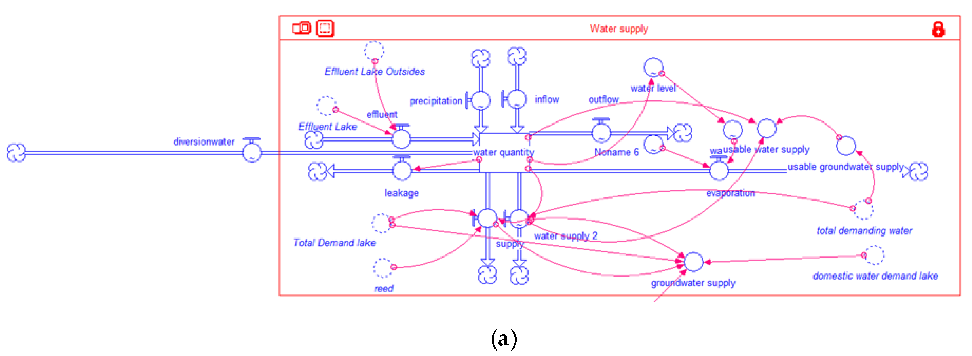
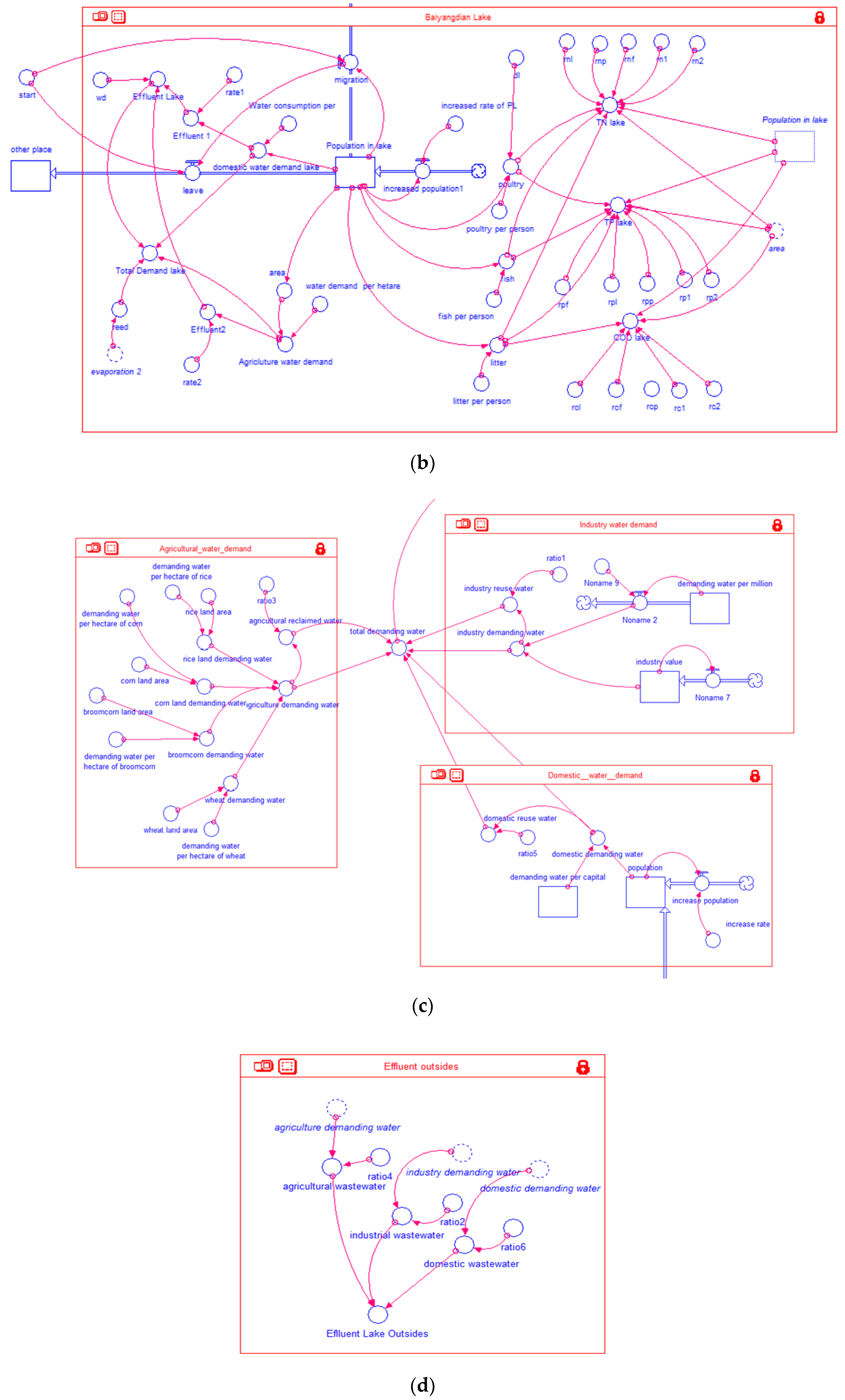
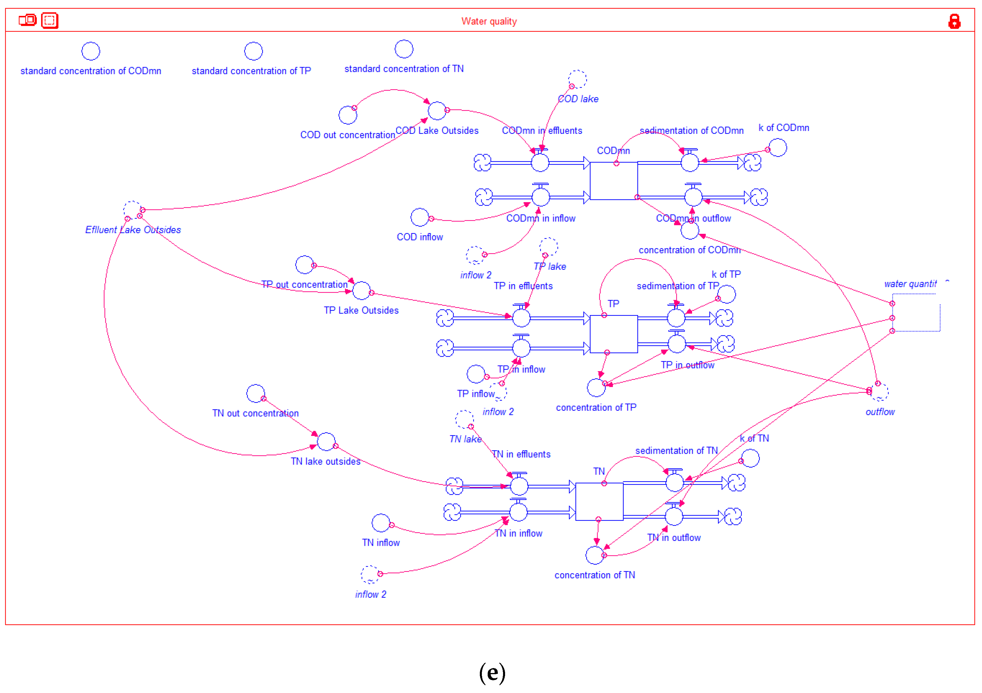
On the basis of the analyses shown in Section 3.3.2 and Section 3.3.3, we built a STELLA model to simulate the water response (Figure 3).

3.3.5. Calibration and Verification

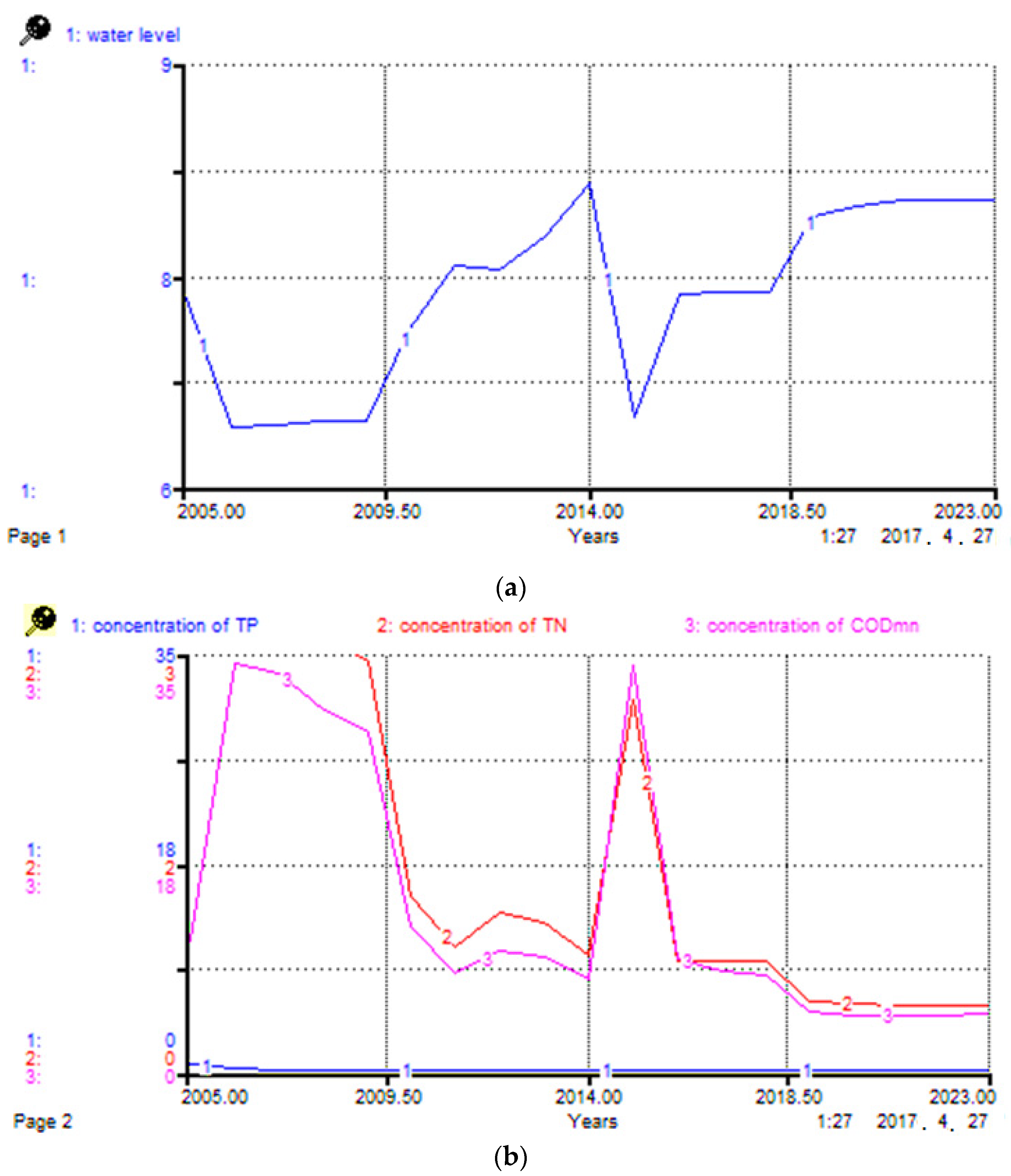
We took 2005 as the initial year (i.e., the data in 2005 as initial values) and used the STELLA model to simulate the water quality and quantity of Baiyangdian Lake from 2006 to 2014. We calibrated the values of parameters based on the measured data in 2005 (Table 1), with differences between simulated values and measured values being limited to 15%. The results of the calibrated model are shown in Figure 4 and the error analysis results are shown in Table 2 and Table 3.
According to Table 2, the error rate between predicted water level and measured data varied from −7.38% to 9.69%. Comparing the simulated pollutant concentrations (Table 3) and the measured data [49] in 2010, the error rate of CODMn concentrations was 14.1%, that of TP was 16.4%, and that of TN was 25%. These were all acceptable in the study, and so the simulated results of the STELLA model were credible.

4. Results and Discussion

4.1. Accessibility to Sustainable Development Goal of Internal Management

Precipitation and potential evapotranspiration data were collected from meteorological stations around the lake. To calculate and compare these, the inflow volume was transformed to runoff depth, which was equal to annual inflow volume divided by catchment area. The spatial distribution of precipitation and potential evapotranspiration were obtained by inverse interpolation in ArcGIS 10.2 software. Time series variation analyses of precipitation and runoff depth from 1961 to 2000 showed that the Hurst coefficient of precipitation was 0.5308, which failed the significance test in α = 0.05; that of runoff depth was 0.7049, which passed the significance test. According to integrated variation analysis of runoff depth, its variation time was 1979 and the variation trend was that of decline.
According to average precipitation, potential evapotranspiration, and runoff, we were able to calculate the actual evapotranspiration, character parameter, and sensitivity coefficients (Table 4). According to the Ecological Environment Assessment Report of Baiyangdian Lake [50], at least 1.26 × 10⁸ m3 runoff supply is needed to maintain a minimum ecological water level (7.3 m) in Baiyangdian Lake. We further calculated the natural runoff of Baiyangdian Lake (Table 4).
Equations (6) and (7) indicated that the impact on runoff of climate change was 34.19% and that of human activities was 65.18%, which were consistent with Hu et al. [51] and Yuan et al. [52]. Absolute values of sensitivity coefficients (s1 and s2) both declined after variation time (Table 4), which indicated that the impact of climate change has been relieved, while that of human activities has been aggravated. Human activity was the main cause of runoff variation.
Comparing measured runoff with natural runoff revealed that the reduction in runoff from water extraction was 20.39 mm, accounting for 84% of human activities. Therefore, if only internal management is used to achieve the sustainable development goal, it is necessary to reduce regional water consumption by 20% under the current conditions. However, population growth is inevitable with the establishment and development of the Xiong’an New Area, and will lead to an increase in water demand. Adequate access to agricultural water demand is closely tied to food security, so it is unwise to reduce agricultural water to achieve the conservation goal. The proportion of industrial water is small and has fallen every year, so the potential of saving industrial water has also declined. It is impossible to achieve a sustainable development goal only through internal management, and integrated cross-basin management needs to be introduced to the Baiyangdian Region.
Mohammad et al. [53] used the standardized precipitation index, the standardized water-level index, and the percent departure from normal rainfall to monitor meteorological and hydrological drought in the Yarmouk Basin, northern Jordan from 1993 to 2014. The results showed that the Yarmouk Basin suffered frequent and irregular extreme meteorological and hydrological drought because of the rainfall pattern changes and precipitation decrease caused by climate change, and the increasing groundwater extraction caused by growing population and water demands. The hydrological drought was more severe than the meteorological drought. These results were consistent with our study. However, Mohammad’s study only evaluated regional water drought and its effects on water resources qualitatively. In our study, we not only identified the variation times and trends of precipitation and runoff, but also quantified the impact of climate change and human activities so that we could have a full and essential understanding of the regional water resource background and provide a basis for water resource response assessment.

4.2. Simulation of Water Resource Response to Integrated Management Policies

4.2.1. Current Eco-Migration Policy

We assumed that most emigration was from the full-water village (refers to the village fully surrounded by water), and other migration was from the part-water village (refers to the village partly surrounded by water). The final goal of the eco-migration policy is to move 80% of villagers from the full-water village until the end of 2020. We assumed that 50% of villagers would move from the full-water village every year. Of these, 50% would settle in Anxin County, and the other villagers would move to other places. In addition, 1 × 10⁸ m3 water would be transferred annually to the Baiyangdian Region to maintain its ecological health. Results of the water resource responses to the eco-migration policy, simulated by the calibrated model, are shown in Table 5. In this situation, groundwater extraction was approximately 3 × 10⁸ m3, which is less than the maximum groundwater extraction volume (19.77 × 10⁸ m3) in Baoding City, Hebei Province.
The population of the full-water village in 2020 would be reduced to 20% of current numbers, and this met the expectations of the policy goal (Table 5). Because transferred water addressed the shortage of local water, it would be possible to maintain the ecological water level (7.3 m) and reduce pollutant concentrations. Predictions of water quality in 2020 are shown in Table 6. Reference to the Environmental quality standards for surface water (GB3838-2002) [54] suggested that the water quality in 2020 could reach class III, which would be compatible with the ecological function of Baiyangdian Lake. Therefore, the eco-migration policy would be of considerable value in quickly improving the ecological and environmental quality, and even in recovering the water ecosystem function.

4.2.2. The Establishment and Development of the Xiong’an New Area

We further analyzed the impact of the Xiong’an New Area on the assumption of the eco-migration policy (Section 4.2.1). We assumed that immigration would begin in 2028. The volume of transferred water would remain at 1 × 10⁸ m3. The constraint conditions of the model were an ecological water level for Baiyangdian Lake of 7.3 m and maximum groundwater extraction volume of 19.77 × 10⁸ m3. The water resource responses are shown in Table 7.
Our simulation suggested that population growth would lead to a sharp increase in water demand and pollutant discharge, exceeding the self-purification capacity and causing severe water deterioration (Table 7). In other words, after establishment and development of the Xiong’an New Area, the water quantity and quality would be damaged, and there would even be a risk of ecosystem function degeneration in the Baiyangdian Region. Therefore, to prevent deterioration of the ecological environment and maintain sustainability, it is a prerequisite to manage water conservation, control the total amount of pollutants, and increase cross-basin transferred water before and during the construction of the Xiong’an New Area.
Odeh et al. [55] compared land use maps with groundwater level spatial distribution maps to analyze the effects of urbanization and agricultural activities on groundwater levels and salinity in Irbid governorate, Jordan from 1984 to 2014, and the results showed that population growth, urban expansion, and agricultural development increased water demands and groundwater extraction, resulting in a groundwater level decrease and salinity of pumped groundwater increase. Hu et al. [56] used participatory rural appraisal methods, ecological footprint, and stochastic impacts by regression on population, affluence, and technology models to assess the environmental impact of eco-migration policies in Huanjiang County, China, and the results showed that population growth and resource over-exploitation caused by eco-migration policies were the main reasons for the negative environmental stress on immigration areas. These results were consistent with our study. However, Odeh’s method and Hu’s methods could only assess the policy impacts based on the current situation, without taking into account the interrelationship between ecosystem and the socio-economic system. As noted in the 2030 Agenda for Sustainable Development [57], one of the main sustainable development goals is to build sustainable cities and communities by guaranteeing adequate water supply. Therefore, effective IWRM should be based on interaction and feedback relationship analysis of water demand subsystems in different scenarios to choose the most sustainable management plan. The policy assessment method based on the SD model built into our study was able to predict water resource responses in different scenarios, with comprehensive consideration of interactive mechanisms between subsystems, and so it was able to provide multi-perspective assessments of policies.

5. Conclusions

Using the Baiyangdian Region—with its severe water shortage and poor habitat quality problems—as a study case, we proposed a multi-angle method combined with hydrological variation analysis and an SD model to assess water resource responses to development and utilization policies. The results showed that human activity, especially water extraction, was the main cause of variations in regional runoff. With high-intensity human activities, it is impossible to achieve sustainable development goals through internal IWRM. Nevertheless, with the help of cross-basin transferred water and eco-migration policies, the ecological water environment could be considerably improved. However, after the establishment and development of the Xiong’an New Area, there will be a new water crisis in the Baiyangdian Region. The study provides a new perspective for regional IWRM study and comparison.
Multi-angle problem identification and IWRM were not only useful in solving water problems in the Baiyangdian Region, but may also be meaningful for the coordinated development of Beijing–Tianjin–Hebei Integration. However, owing to the objective limitations of the current data, there were some deficiencies in the study: ignorance of changes and potential risks during the year and no consideration of reactions between pollutants (owing to the lack of clear explanations of reaction mechanisms). Future work should focus on a detailed study of the mechanisms involved in physical, chemical, and biological reactions over a short time scale to improve and popularize our research results.

Author Contributions

Conceptualization, Y.-y.L. and X.W.; methodology, Y.-y.L.; software, Z.-m.L. and Y.-y.L.; validation, Z.-m.L. and W.-s.X.; resources, D.L., Y.-l.Z., and Y.-y.L.; data curation, Y.-y.L.; writing—original draft preparation, Z.-m.L., Y.-y.L., and W.-s.X.; writing—review and editing, X.W.; visualization, Z.-m.L. and Y.-y.L.; supervision, X.W. and C.-h.L. All authors have read and agreed to the published version of the manuscript.

Funding

This research was financially supported by the National Natural Science Foundation of China (Grant No. 51679008, 51721093), the Major Science and Technology Program for Water Pollution Control and Treatment of China (Grant No. 2018ZX07110001), and the National key research and development program of China (Grant No. 2017YFC0404505).

Acknowledgments

We thank Liwen Bianji, Edanz Editing China (www.liwenbianji.cn/ac) for editing the English text of a draft of this manuscript. We would like to extend special thanks to the editor and the anonymous reviewers for their valuable comments in greatly improving the quality of this paper.

Conflicts of Interest

The authors declare no conflict of interest. The funders had no role in the design of the study; in the collection, analyses, or interpretation of data; in the writing of the manuscript, or in the decision to publish the results.

References

  1. Wang, Q.; Li, S.; He, G.; Li, R.; Wang, X. Evaluating sustainability of water-energy-food (WEF) nexus using an improved matter-element extension model: A case study of China. J. Clean. Prod. 2018, 202, 1097–1106. [Google Scholar] [CrossRef]
  2. Huang, D.; Li, G.; Sun, C.; Liu, Q. Exploring interactions in the local water-energy-food nexus (WEF-Nexus) using a simultaneous equations model. Sci. Total Environ. 2020, 703, 135034. [Google Scholar] [CrossRef] [PubMed]
  3. Jin, N.; Ren, W.; Tao, B.; He, L.; Ren, Q.F.; Li, S.Q.; Yu, Q. Effects of water stress on water use efficiency of irrigated and rainfed wheat in the Loess Plateau, China. Sci. Total Environ. 2018, 642, 1–11. [Google Scholar] [CrossRef]
  4. Hart, O.E.; Halden, R.U. On the need to integrate uncertainty into US water resource planning. Sci. Total Environ. 2019, 691, 1262–1270. [Google Scholar] [CrossRef]
  5. Jiang, L.; Jiapaer, G.; Boa, A.; Yuan, Y.; Zheng, G.; Guo, H.; Yu, T.; De Maeyer, P. The effects of water stress on croplands in the Aral Sea basin. J. Clean. Prod. 2020, 254, 120114. [Google Scholar] [CrossRef]
  6. Liu, J.; Yang, H.; Gosling, S.N.; Kummu, M.; Florke, M.; Pfister, S.; Hanasaki, N.; Wada, Y.; Zhang, X.; Zheng, C.; et al. Water scarcity assessments in the past, present and future. Earths Future 2017, 5, 545–559. [Google Scholar] [CrossRef]
  7. Xie, P.; Zhuo, L.; Yang, X.; Huang, H.; Gao, X.; Wu, P. Spatial-temporal variations in blue and green water resources, water footprints and water scarcities in a large river basin: A case for the Yellow River basin. J. Hydrol. 2020, 590, 125222. [Google Scholar] [CrossRef]
  8. Mehta, L. Whose scarcity? Whose property? The case of water in western India. Land Use Policy 2007, 24, 654–663. [Google Scholar] [CrossRef]
  9. Hussein, H. Lifting the veil: Unpacking the discourse of water scarcity in Jordan. Environ. Sci. Policy 2018, 89, 385–392. [Google Scholar] [CrossRef]
  10. Edwards, G. Shifting constructions of scarcity and the neoliberalization of Australian water governance. Environ. Plan. A 2013, 45, 1873–1890. [Google Scholar] [CrossRef]
  11. Yao, Y.; Sun, J.; Tian, Y.; Zheng, C.; Liu, J. Alleviating water scarcity and poverty in drylands through telecouplings: Vegetable trade and tourism in northwest China. Sci. Total Environ. 2020, 741, 140387. [Google Scholar] [CrossRef] [PubMed]
  12. Hussein, H.; Menga, F.; Greco, F. Monitoring Transboundary Water Cooperation in SDG 6.5.2: How a Critical Hydropolitics Approach Can Spot Inequitable Outcomes. Sustainability 2018, 10, 3640. [Google Scholar] [CrossRef] [Green Version]
  13. Finger, M.; Tamiotti, L.; Allouche, J. The Multi—Governance of Water: Four Case Studies; State University of New York Press: New York, NY, USA, 2006. [Google Scholar]
  14. Wang, K.; Davies, E.G.R.; Liu, J. Integrated water resources management and modeling: A case study of Bow river basin, Canada. J. Clean. Prod. 2019, 240, 118242. [Google Scholar] [CrossRef]
  15. Chang, I.S.; Zhao, M.; Chen, Y.; Guo, X.; Zhu, Y.; Wu, J.; Yuan, T. Evaluation on the integrated water resources management in China’s major cities—Based on City Blueprint® Approach. J. Clean. Prod. 2020, 262, 121410. [Google Scholar] [CrossRef]
  16. Nikolic, V.V.; Simonovic, S.P.; Milicevic, D.B. Analytical Support for Integrated Water Resources Management: A New Method for Addressing Spatial and Temporal Variability. Water Resour. Manag. 2012, 27, 401–417. [Google Scholar] [CrossRef]
  17. Liu, D.; Guo, S.; Shao, Q.; Liu, P.; Xiong, L.; Wang, L.; Hong, X.; Xu, Y.; Wang, Z. Assessing the effects of adaptation measures on optimal water resources allocation under varied water availability conditions. J. Hydrol. 2018, 556, 759–774. [Google Scholar] [CrossRef]
  18. Holling, C.S.; Meffe, G.K. Command and Control and the Pathology of Natural Resource Management. Conserv. Biol. 1996, 10, 328–337. [Google Scholar] [CrossRef] [Green Version]
  19. Anwar Sadat, M.; Guan, Y.; Zhang, D.; Shao, G.; Cheng, X.; Yang, Y. The associations between river health and water resources management lead to the assessment of river state. Ecol. Indic. 2020, 109, 105814. [Google Scholar] [CrossRef]
  20. Guo, X.; Feng, Q.; Si, J.; Xi, H.; Zhao, Y.; Deo, R.C. Partitioning groundwater recharge sources in multiple aquifers system within a desert oasis environment: Implications for water resources management in endorheic basins. J. Hydrol. 2019, 579, 124212. [Google Scholar] [CrossRef]
  21. Kanakoudis, V.; Tsitsifli, S.; Papadopoulou, A.; Cencur Curk, B.; Karleusa, B. Water resources vulnerability assessment in the Adriatic Sea region: The case of Corfu Island. Environ. Sci. Pollut. Res. 2017, 24, 20173–20186. [Google Scholar] [CrossRef]
  22. de Wet, C.; Odume, O.N. Developing a systemic-relational approach to environmental ethics in water resource management. Environ. Sci. Policy 2019, 93, 139–145. [Google Scholar] [CrossRef]
  23. McGinnis, M.D.; Ostrom, E. Social-ecological system framework: Initial changes and continuing challenges. Ecol. Soc. 2014, 19, 30. [Google Scholar] [CrossRef] [Green Version]
  24. Mirchi, A.; Madani, K.; Watkins, D.; Ahmad, S. Synthesis of System Dynamics Tools for Holistic Conceptualization of Water Resources Problems. Water Resour. Manag. 2012, 26, 2421–2442. [Google Scholar] [CrossRef]
  25. Kotir, J.H.; Smith, C.; Brown, G.; Marshall, N.; Johnstone, R. A system dynamics simulation model for sustainable water resources management and agricultural development in the Volta River Basin, Ghana. Sci. Total Environ. 2016, 573, 444–457. [Google Scholar] [CrossRef] [PubMed]
  26. Stave, K.A. A system dynamics model to facilitate public understanding of water management options in Las Vegas, Nevada. J. Environ. Manag. 2003, 67, 303–313. [Google Scholar] [CrossRef]
  27. Zhou, Y.; Guo, S.; Xu, C.-Y.; Liu, D.; Chen, L.; Ye, Y. Integrated optimal allocation model for complex adaptive system of water resources management (I): Methodologies. J. Hydrol. 2015, 531, 964–976. [Google Scholar] [CrossRef]
  28. Wang, W.; Shao, Q.; Yang, T.; Peng, S.; Xing, W.; Sun, F.; Luo, Y. Quantitative assessment of the impact of climate variability and human activities on runoff changes: A case study in four catchments of the Haihe River basin, China. Hydrol. Process. 2013, 27, 1158–1174. [Google Scholar] [CrossRef]
  29. Zhao, G.; Tian, P.; Mu, X.; Jiao, J.; Wang, F.; Gao, P. Quantifying the impact of climate variability and human activities on streamflow in the middle reaches of the Yellow River basin, China. J. Hydrol. 2014, 519, 387–398. [Google Scholar] [CrossRef]
  30. Li, Z.; Li, Q.; Wang, J.; Feng, Y.; Shao, Q. Impacts of projected climate change on runoff in upper reach of Heihe River basin using climate elasticity method and GCMs. Sci. Total Environ. 2020, 716, 137072. [Google Scholar] [CrossRef] [PubMed]
  31. Mu, X.; Wang, H.; Zhao, Y.; Liu, H.; He, G.; Li, J. Streamflow into Beijing and Its Response to Climate Change and Human Activities over the Period 1956–2016. Water 2020, 12, 622. [Google Scholar] [CrossRef] [Green Version]
  32. Xu, X.; Yang, D.; Yang, H.; Lei, H. Attribution analysis based on the Budyko hypothesis for detecting the dominant cause of runoff decline in Haihe basin. J. Hydrol. 2014, 510, 530–540. [Google Scholar] [CrossRef]
  33. Zhang, K.; Ruben, G.B.; Li, X.; Li, Z.; Yu, Z.; Xia, J.; Dong, Z. A comprehensive assessment framework for quantifying climatic and anthropogenic contributions to streamflow changes: A case study in a typical semi-arid North China basin. Environ. Model. Softw. 2020, 128, 104704. [Google Scholar] [CrossRef]
  34. Hebei Provincial Government. Ecology and Environment Protection and Improvement Plan for Baiyangdian Basin (2018–2035); Hebei Provincial Government: Shijiazhuang, China, 2019. (In Chinese)
  35. China Meteorological Data Service Center. Available online: http://data.cma.cn/ (accessed on 27 November 2016). (In Chinese).
  36. Environmental Protection Bureau of Baoding. Baoding Municipal State of the Environment; Environmental Protection Bureau of Baoding: Baoding, China, 2006. (In Chinese)
  37. Hebei Province Department of Water Resources. Hebei Provincial Water Resources Bulletin; Hebei Province Department of Water Resources: Shijiazhuang, China, 2006. (In Chinese)
  38. Heibei General Hydrometric Station. Hydrologic Data Yearbook of People’s Republic of China, 4th ed.; Haihe River Basin; Heibei General Hydrometric Station: Shijiazhuang, China, 2006; Volume 3. (In Chinese)
  39. Heibei Provincial Government. Heibei Provincial Economic Yearbook; China Statistics Press: Beijing, China, 2006. (In Chinese)
  40. Baoding Municipal Statistical Bureau. Economic Statistical Yearbook of Baoding; China Statistics Press: Beijing, China, 2006. (In Chinese) [Google Scholar]
  41. Hebei Provincial Bureau of Statistics. National Economic and Social Development Statistics Bulletin of Hebei Province; Hebei Provincial Bureau of Statistics: Shijiazhuang, China, 2006. (In Chinese)
  42. Resource and Environment Data Cloud Platform. Available online: http://www.resdc.cn/ (accessed on 27 November 2016). (In Chinese).
  43. Budyko, M.I. Climate and Life; Academic Press: New York, NY, USA, 1974. [Google Scholar]
  44. Fu, B. On the calculation of the evaporation from land surface. Chin. J. Atmos. Sci. 1981, 5, 23–31. (In Chinese) [Google Scholar]
  45. Deng, R.Q. Analysis and Assessment of Water Resources-Ecology-Socioeconomic System of Baiyangdian Wetland; Hebei Agricultural University: Baoding, China, 2011. [Google Scholar]
  46. Zhao, X.; Cui, B.; Yang, Z. A study of the lowest ecological water level of Baiyangdian Lake. Acta Ecol. Sin. 2005, 25, 1033–1040. (In Chinese) [Google Scholar]
  47. Han, Q.; Tong, R.; Sun, W.; Zhao, Y.; Yu, J.; Wang, G.; Shrestha, S.; Jin, Y. Anthropogenic influences on the water quality of the Baiyangdian Lake in North China over the last decade. Sci. Total Environ. 2020, 701, 134929. [Google Scholar] [CrossRef]
  48. Yang, Y.; Yin, X.; Yang, Z. Environmental flow management strategies based on the integration of water quantity and quality, a case study of the Baiyangdian Wetland, China. Ecol. Eng. 2016, 96, 150–161. [Google Scholar] [CrossRef] [Green Version]
  49. Yang, L.; Chen, S. Assessment of water environment quality of Baiyang Lake. South—North Water Transf. Water Sci. Technol. 2015, 13, 457–462. (In Chinese) [Google Scholar]
  50. Hebei Provincial Environmental Scientific Research. Ecological Environment Assessment Report of Baiyangdian Lake; Hebei Provincial Environmental Scientific Research: Shijiazhuang, China, 2006. (In Chinese) [Google Scholar]
  51. Hu, S.; Liu, C.; Zheng, H.; Wang, Z.; Yu, J. Assessing the impacts of climate variability and human activities on streamflow in the water source area of Baiyangdian Lake. J. Geogr. Sci. 2012, 22, 895–905. [Google Scholar] [CrossRef]
  52. Yuan, Y.; Yan, D.; Wang, H.; Wang, Q. Attributive analysis on evolution of inflow to Baiyangdian Wetland. Water Resour. Hydropower Eng. 2013, 44, 1–4, 23. (In Chinese) [Google Scholar]
  53. Mohammad, A.H.; Jung, H.C.; Odeh, T.; Bhuiyan, C.; Hussein, H. Understanding the impact of droughts in the Yarmouk Basin, Jordan: Monitoring droughts through meteorological and hydrological drought indices. Arab. J. Geosci. 2018, 11, 103. [Google Scholar] [CrossRef] [Green Version]
  54. Ministry of Ecology and Environment of the People’s Republic of China. Environmental Quality Standards for Surface Water (GB3838-2002); China Environmental Press: Beijing, China, 2002. (In Chinese)
  55. Odeh, T.; Mohammad, A.H.; Hussein, H.; Ismail, M.; Almomani, T. Over-pumping of groundwater in Irbid governorate, northern Jordan: A conceptual model to analyze the effects of urbanization and agricultural activities on groundwater levels and salinity. Environ. Earth Sci. 2019, 78, 40. [Google Scholar] [CrossRef] [Green Version]
  56. Hu, Y.; Zhou, W.; Yuan, T. Environmental impact assessment of ecological migration in China: A survey of immigrant resettlement regions. J. Zhejiang Univ. Sci. A 2018, 19, 240–254. [Google Scholar] [CrossRef]
  57. United Nations. Transforming our World; The 2030 Agenda for Sustainable Development (A/RES/70/1) United Nations: New York, NY, USA, 2015. [Google Scholar]
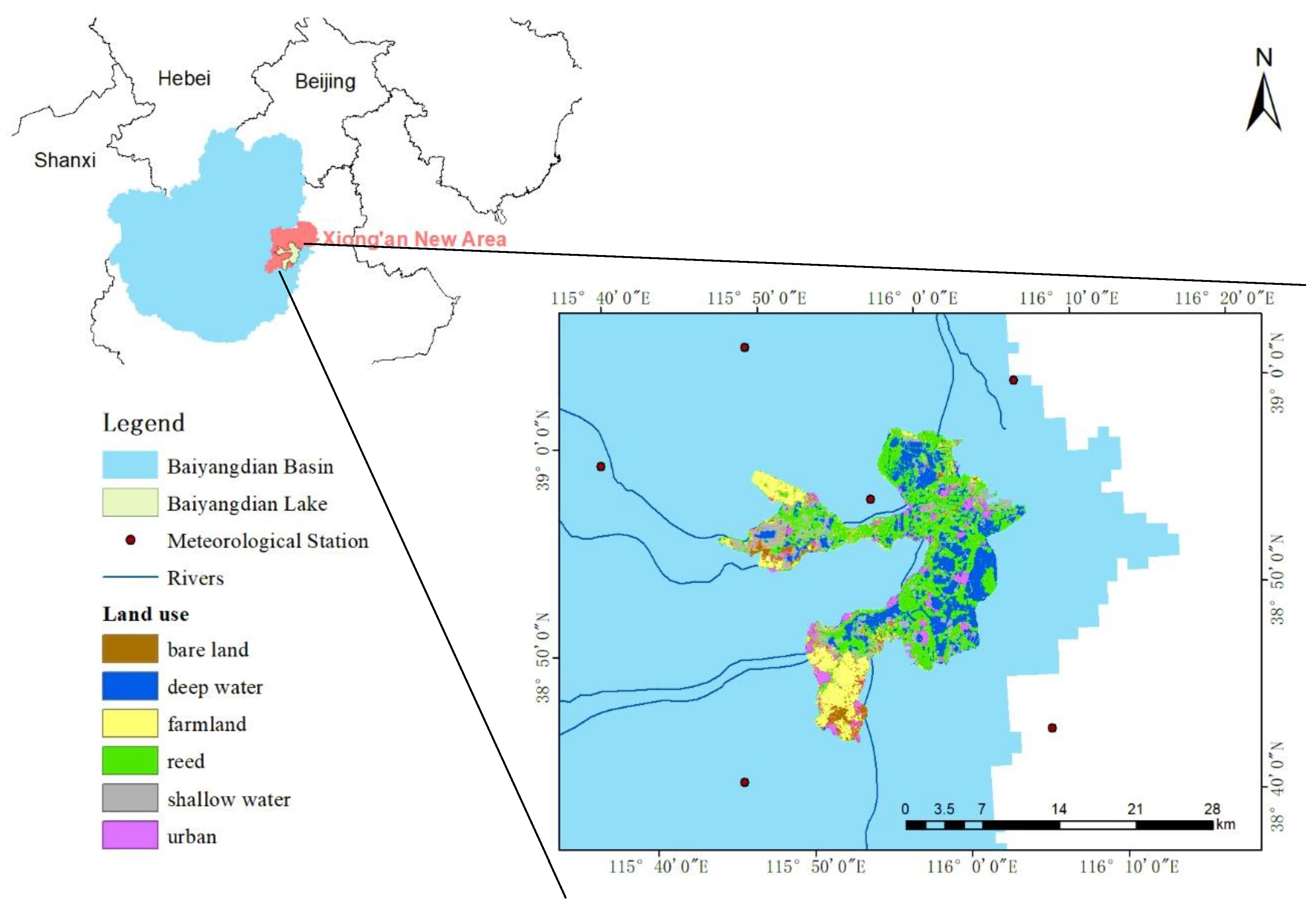
Figure 1. Location of the Baiyangdian Region, North China.
Sustainability 12 05814 g001
Figure 2. Assessment process combing hydrological variation analysis and system dynamics modeling.
Sustainability 12 05814 g002
Figure 3. STELLA model of water resource response to eco-migration policy: (a) water supply of Baiyangdian Lake; (b) water demand and wastewater discharge of lake interior; (c) water demand of lake exterior; (d) wastewater discharge of lake exterior; (e) pollutant load in Baiyangdian Lake.
Sustainability 12 05814 g003aSustainability 12 05814 g003bSustainability 12 05814 g003c
Figure 4. Simulation results of (a) water level and (b) pollutant concentrations.
Sustainability 12 05814 g004
Table 1. Calibrated values of parameters.
ParametersValuesParametersValues
Annual net population growth rate in exterior8.0%Annual net population growth rate in interior8.5%
Leakage parameter0.100Annual irrigation water demand per square meter of rice0.847 m3/a
Annual irrigation water demand per square meter of corn0.545 m3/aAnnual irrigation water demand per square meter of wheat0.604 m3/a
Annual irrigation water demand per square meter of cotton0.450 m3/aDischarge rate of agricultural wastewater4.0%
Water demand of per 10,000 yuan industrial GDP121.69 m3Discharge rate of industrial wastewater44.3%
Reuse rate of industrial wastewater4.0%Annual per capita domestic water demand in exterior438 m3/a
Discharge rate of domestic wastewater in exterior17.6%Reuse rate of domestic wastewater in exterior4.0%
Annual per capita domestic water demand in interior110 m3/aEntry rate of domestic wastewater in interior90.0%
Per capita farmland area in interior6723.964 m2Number of ducks per capita in interior3.500
Number of fish per capita in interior5.800Annual CODMn concentration of per unit domestic wastewater1.640 × 108 g/a
Annual CODMn concentration in inflow of per unit duck 217.783 g/aAnnual TN concentration in inflow of per unit duck43.800 g/a
Annual TP concentration in inflow of per unit duck0.081 g/aAnnual average removal rate of TN85.0%
Annual average removal rate of TP90.0%Annual average removal rate of CODMn50.0%
Table 2. Simulation results and verification of water quantity.
YearSimulated Water Quantity (× 108 m3)Predicted Water Level (m)Measured Water Level (m)Error (%)
20051.167.347.241.37
20060.576.696.80−1.61
20070.666.816.741.03
20080.646.797.06−3.79
20090.696.847.14−4.27
20101.237.377.064.40
20111.827.747.069.65
20121.957.827.583.10
20132.498.108.44−4.07
20141.877.778.39−7.38
Table 3. Simulation results of water quality.
YearCODMn (mg/L)TN (mg/L)TP (mg/L)Water Level (m)
200511.053.670.677.34
200625.243.460.206.69
200722.912.580.106.81
200822.452.330.086.79
200920.892.200.086.84
201011.261.170.047.37
20118.831.000.047.74
20129.711.110.047.82
20139.011.030.048.10
20149.040.750.027.77
Table 4. Changes in natural parameters in the Baiyangdian Region.
E (mm)P (mm)Q (mm)Qr (mm)ωs1s2
Before variation time488.68551.4646.5773.392.640.29−0.087
After variation time453.15502.399.7456.952.650.26−0.072
E is evapotranspiration, P is precipitation, Q is measured runoff, Qr is natural runoff, ω is character parameter, and s1 and s2 are sensitivity coefficients.
Table 5. Effect of eco-migration policies in current conditions.
YearPopulation of the Full-Water VillagePopulation of Eco-MigrationWater Level (m)CODMn
(mg/L)
TN (mg/L)TP (mg/L)Transferred Water Volume
(× 108 m3)
2015108,82206.4834.12.680.101.00
2016109,74607.408.890.750.031.00
2017110,67823,5197.437.850.740.031.00
201864,57913,7237.427.620.760.031.00
201937,6818,0077.646.010.600.031.00
202021,9874,6727.755.460.550.021.00
Table 6. Water quality of Baiyangdian Lake in 2020.
PollutantsStandards (mg/L)Assessment
Class IClass IIClass IIIClass IVClass VPollutant Concentration in 2020 (mg/L)Water Quality Class
TP0.010.0250.050.100.200.02I
TN0.200.501.001.502.000.55III
CODMn15152030405.46I
Table 7. Impact of establishment and development of the Xiong’an New Area.
YearWater Level (m)Water Demands (×108 m3)CODMn (mg/L)TN (mg/L)TP (mg/L)Class of Water Quality
20297.313.62558.819.380.50Inferior V
20307.313.98550.036.250.30Inferior V
20317.314.35542.274.740.20Inferior V
20327.314.72536.313.830.20Inferior V
20337.313.62558.819.380.50Inferior V