3.1.2. Change Characteristics of Spatial Pattern
As shown in
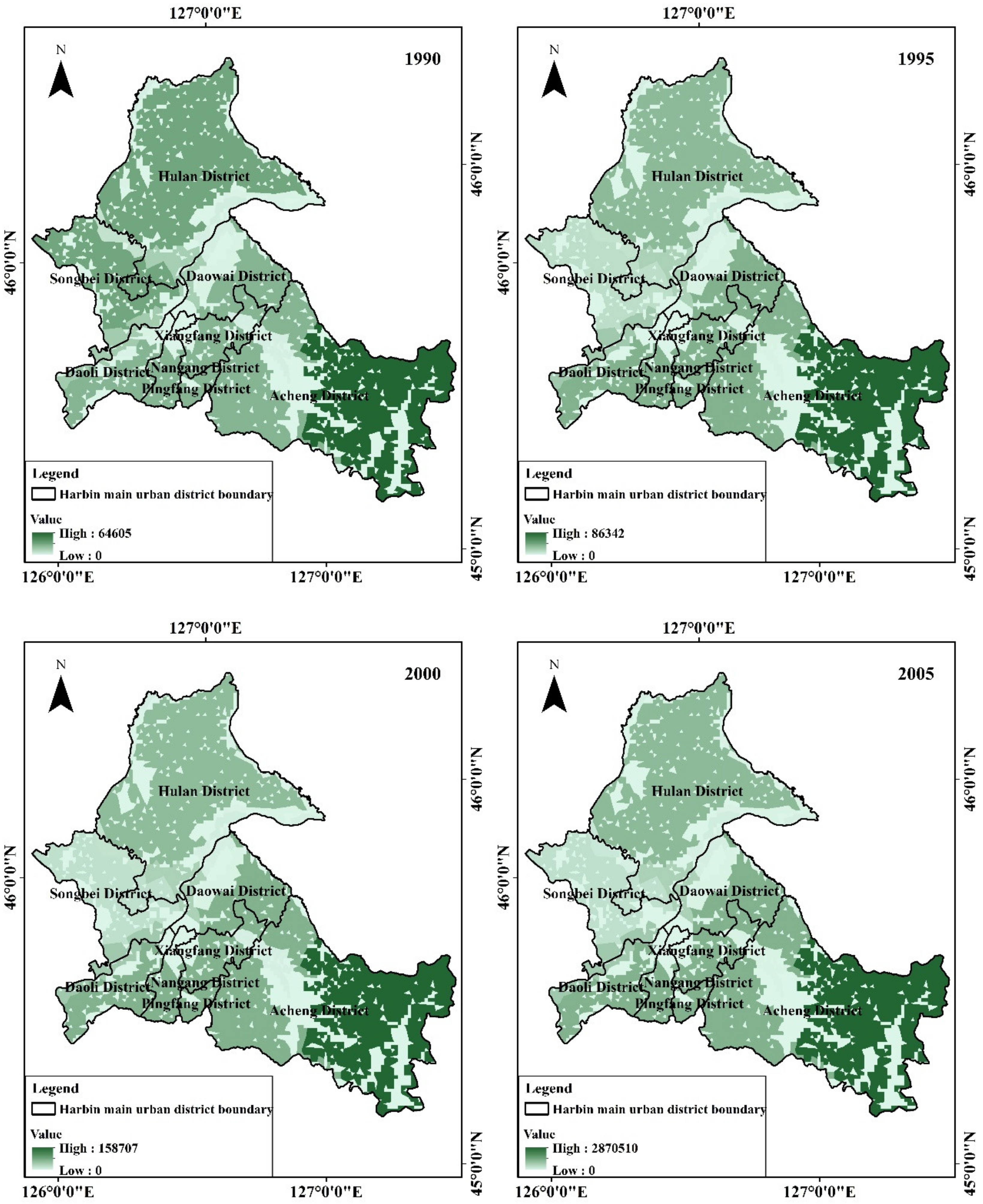
Figure 1, the LUCC in the study area were mainly arable land, mostly occurring in the vast plain area in the middle, which is currently the main development and planned development area in the urban center of Harbin and is located at the terrace on both sides of Songhua River.
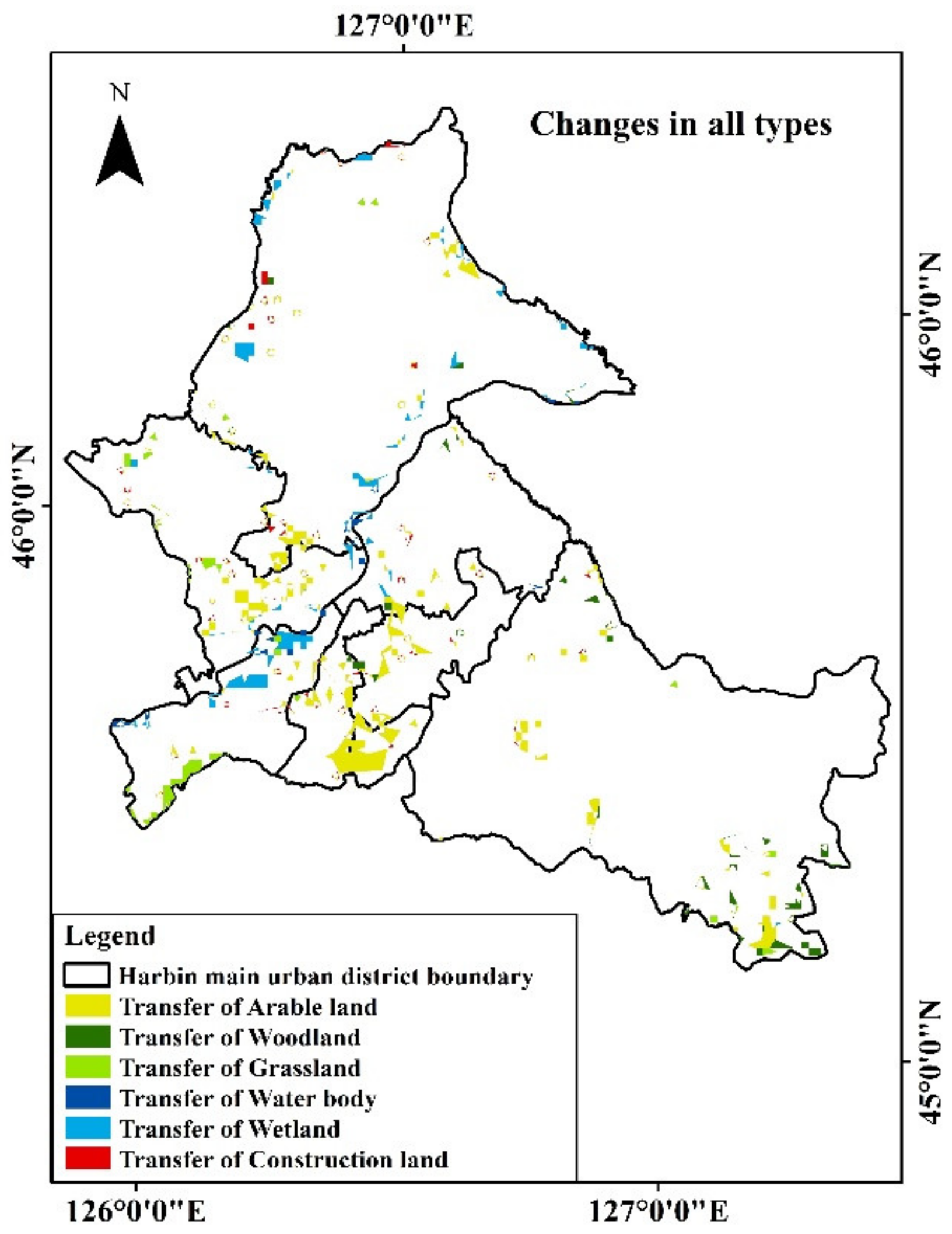
In the change of arable land, as shown in
Figure 2, 73.5% of the areas converted to construction land are mostly located in Nangang district, Xiangfang district, and Pingfang district, which is due to Harbin’s “South Extension” policy. The other parts of the conversion to ecological land were due to “Grain for Green” and other policy actions such as ecological protection and land consolidation.
The woodland in the study area is concentrated in the southeast of the study area, which is located in the hilly area adjacent to the residual vein of Zhang Guangcai Ridge. The total change is small and scattered. Most of its changes have been through conversion to arable land, which is located in Acheng district. The proportion of grassland area in the study area is not large, and about one-third of the area has been converted to arable land, while the others were not more than 3 km
2. Most of the changed areas are located in the south of Daoli district, and in the middle and north of Songbei district. Songhua River passes through the central part of Harbin City, most of the water body and wetland are transformed into each other, the part converted into other categories of land use/cover. Among them, the area of water body converted into wetland was the highest in the water body conversion area, while the area of the wetland that was converted into arable land was the highest of converted into arable land area. There are parts of construction land that were converted into arable land, grassland, and wetland, mostly located in the central and eastern parts of Hulan district [
39,
40,
41], but the total area was small, and the biggest part was converted into arable land.
All seven types of land use/cover in Harbin, except bare land, have transfer-in and transfer-out areas. Four of the six types showed a reduced LUCC while only the area of water cover and construction land showed an increase, which is consistent with the above-mentioned in the previous section. The area of ecological land transferred to non-ecological land was the largest and is mostly located in the urban development center. The areas where ecological land was converted into ecological land are scattered and mostly located at the boundary of the study area. Limited parts of non-ecological land were transferred to ecological land and are located in the central and eastern parts of Hulan district.
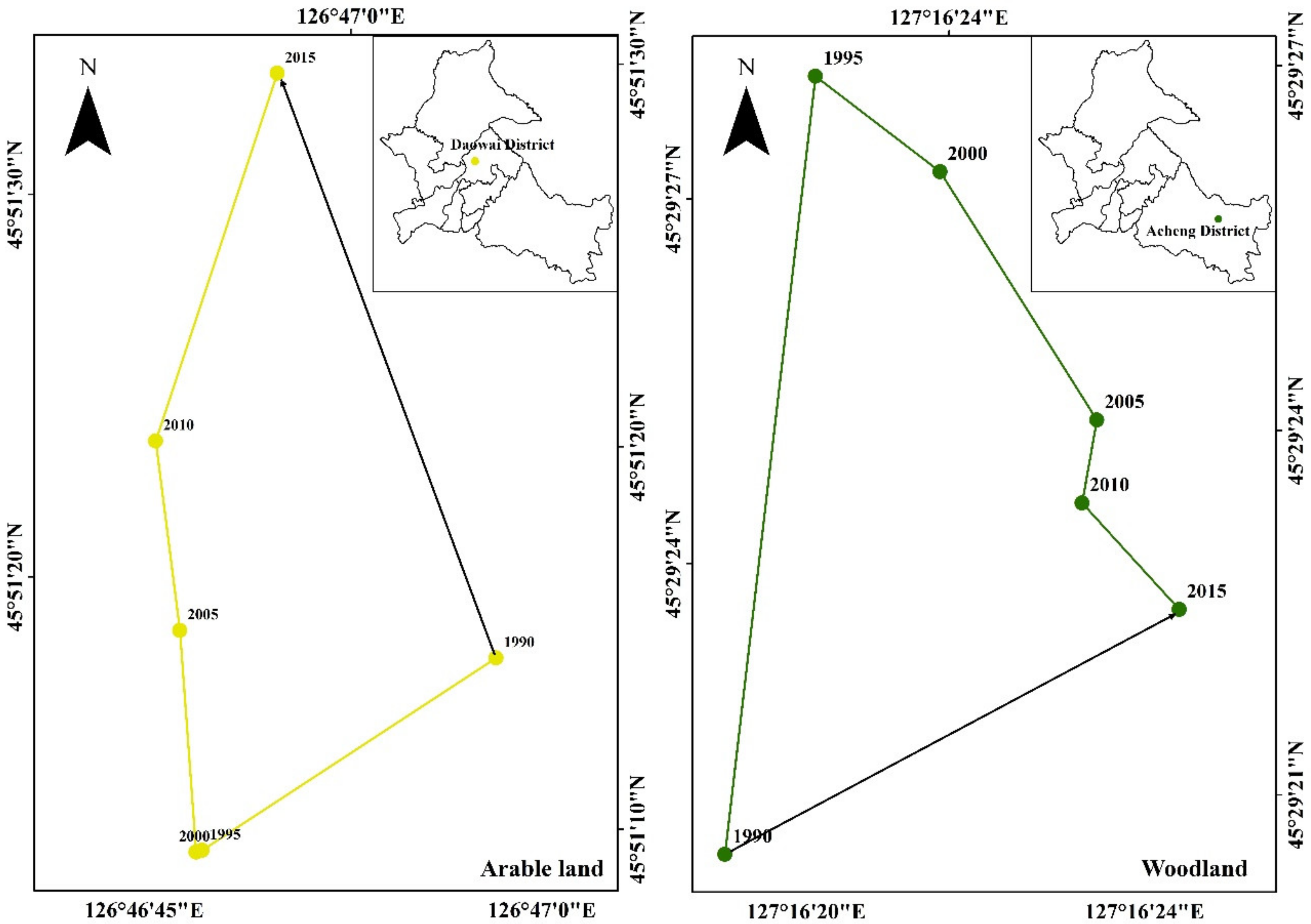
As shown in
Figure 3, the barycenter of the arable land in Harbin research area is located in the Daowai district and at the first terrace formed by Songhua River. Harbin is an important commodity grain production base in China due to its deep soil layer and fertile soil. However, Daowai district is also an area in the central part of Harbin City. With the acceleration of urbanization, the land in the original suburbs of the city has begun to urbanize, and various changes in land use/cover have taken place, shifting the barycenter of arable land use in Daowai district generally in the northwest direction, toward the north of the Songhua River bank at a distance of about 519 m. Similar to the above contents, the longest distance over which the barycenter of arable land is shifted, was reported from 2010 to 2015, and was about 322 m, while the shortest distance was reported from 1995 to 2000, and was only about 5 m.
Harbin woodland is seen to be concentrated in the entire southeast area of Acheng district. Based on the above-mentioned, it can be seen that the woodland area was reduced, and the southernmost part of Acheng district is one of the regions where LUCC is concentrated. From 1990 to 2015, the barycenter of the woodland moved to the east of the eastern boundary line of Acheng district in a general northeast direction and over a distance of 135 m. Similar to the above contents, the longest shift distance of the woodland barycenter was about 205 m and had occurred between 1990 and 1995, while the shortest was about 22 m from 2005 to 2010.
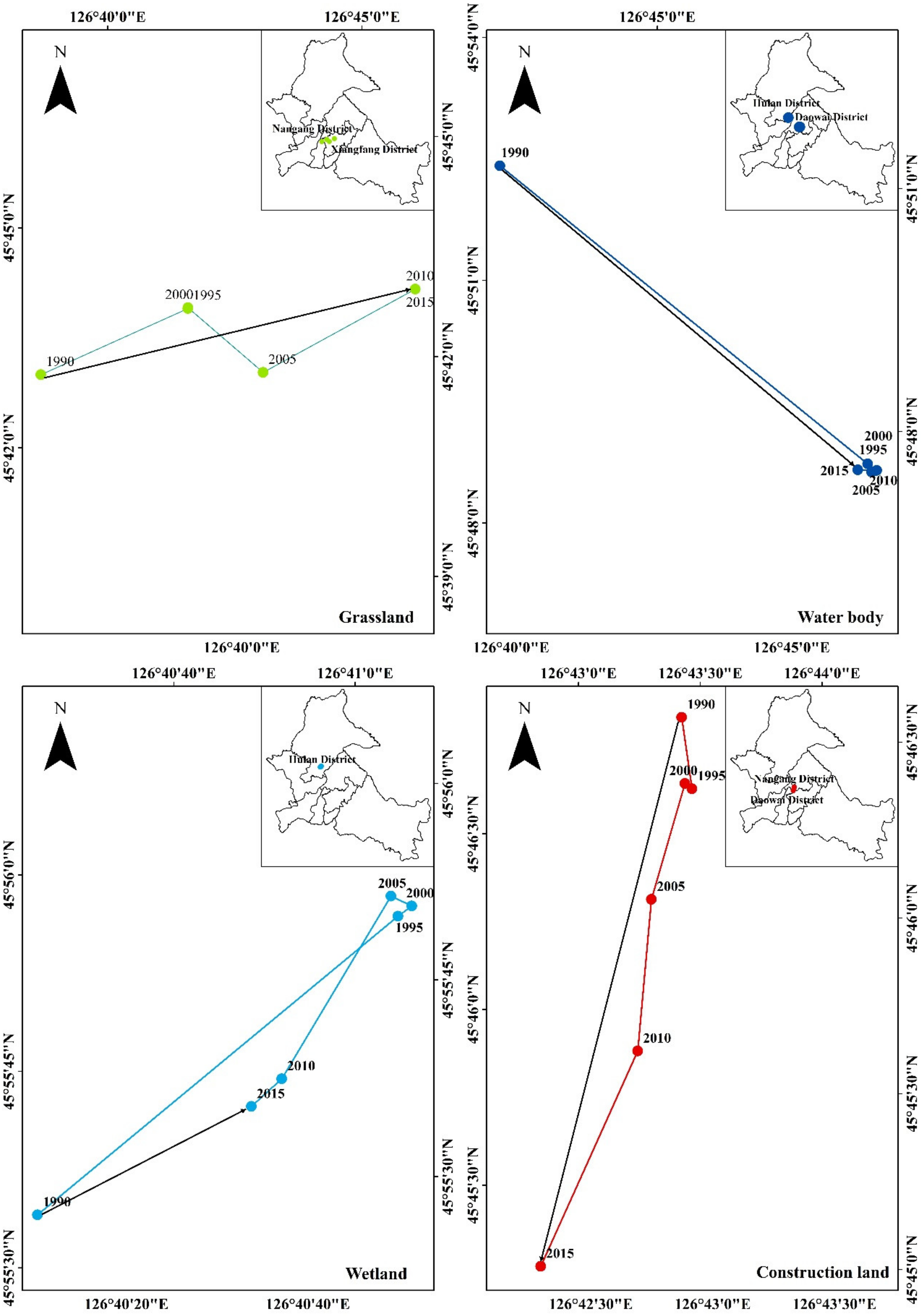
The distribution of the grassland is located in Songbei district, Daoli district, and Acheng district. Due to the accelerated urbanization process, the urban area has increased, whereas the grassland area in Songbei district and Daoli district has begun to decrease. The barycenter of the grassland has shifted to the east of the study area, with a distance of approximately 9983 m in the northeast. Similar to the above contents, the longest shift distance of the grassland barycenter was from 1990 to 1995 and was about 4190 m, and the shortest distance was reported from 2010 to 2015 with no shift of barycenter.
Songhua River runs from the central part of Harbin City. The city’s water and wetland centers are located in Daowai and Hulan districts. According to the dynamic degree of LUCC, the water area increased from 1990 to 2015. Therefore, the barycenter of the water body moved from the position near the shore of the off-road area to the south of the off-road area in a general southeast direction and for a distance of about 11,060 m. Similar to the above contents, the longest distance over which the water body shifted its barycenter was reported from 1990 to 1995 and was about 11,150 m, while the shortest distance was reported from 1995 to 2000 with no shift in the barycenter. The barycenter of the wetland is located in Hulan district. From 1990 to 2015, it moved in the eastern direction of Hulan district in a general northeast direction and over a distance of 581 m. Similar to the above contents, the longest shift distance of wetland barycenter was about 1134 m from 1990 to 1995, and the shortest was about 42 m from 1995 to 2000.
With the concept of ecological protection and sustainable development deeply rooted in people’s hearts and practices, the depth of urban land use has increased, and the barycenter of construction land has been centralized, moving from the off-road area to Nangang district in general southwest direction and over a distance of about 3068 m. Similar to the above contents, the longest distance over which the barycenter of construction land shifted was reported to be in the period 2010–2015 and was about 1281 m, and the shortest distance was reported in the period 1995–2000 and was about 48 m.
From 1990 to 2015, the three bare lands have not changed. Thus, the barycenter has not changed either; it is located in the northwest part of the Acheng district.
The barycenter of land use/cover shifted from Daowai district to Xiangfang district, over a distance of 2750 m in the southeast direction from 1990 to 2015. Consistent with the above-mentioned changes and Harbin’s “southern expansion” policy, the longest distance of land use/cover barycenter shift was from 1990 to 1995, at about 2015 m, while the shortest distance was reported from 1995 to 2000, at about 8 m [
43,
44,
45].
As shown in
Table 4, the self-adjacency probability of each type is above 85%. In contrast, the adjacency probability with other types is low, not more than 10%, indicating that each land use/cover type in the study area is relatively concentrated, and the degree of fragmentation is low.
From a single type of spatial self-adjacency, the study area has the highest probability of arable land and woodland self-adjacency, with 98.32% and 98.17%, respectively, indicating that arable land and forest land are mostly concentrated and contiguous, with strong spatial aggregation. Although there is greater than 90% probability of grassland, water body, wetland, and construction land being adjacent to each other, this probability is smaller than that of adjacency between arable land and woodland, which indicates that the spatial aggregation of these land use/cover types is lower than that of arable land and woodland, and their distribution is relatively loose. Compared with other types, the probability of self-adjacency was lowest for the bare land, and only adjacent to the arable land and woodland.
According to the different types of spatial adjacency, except the probability of adjacency of water body to wetland, the adjacency probability of various types with arable land is higher than that of other types, which indicates that arable land holds an absolute advantage area in the whole research area, and the highest adjacency probability was the construction land. Construction land is mainly surrounded by arable land; hence arable land is the main source of construction land area expansion.
From the conversion trend between the same types, as shown in
Figure 4a, the indices of arable land and woodland are 0.98 and 0.99, respectively, approaching 1, which indicates high stability. Although the change area of arable land in the study area is in the highest proportion, its base number is large and the probability of self-adjacency is high; woodland is concentrated in the southeast of the study area, with high probability of self-adjacency and low proportion of change area. Therefore, arable land and woodland have higher self-stability and lower dynamic degrees. The indexes of grassland, water body, and wetland are the lowest at 0.70, 0.94, and 0.92, respectively, indicating relatively poor stability and ease of transformation to other categories. The water body has a higher tendency index of transforming to the same type compared to wetland, because it is surrounded by wetland. At the early stage of research, the proportions of grassland, water body, and wetland in the seven types in the study area were relatively low. Although the proportion of change area is low, its dynamic degree is high, and its self-stability is poor. The index of construction land and bare land is higher than 1, which indicates that the two types are relatively stable and are less likely to be converted to other types of land use under the conditions of adjacency. During the 25 years, only 3.8% of the construction land in the research area was transferred to other types, 31.5% from other types, a net increase of about one third of the area in 1990. The area of bare land has not changed, nor has it been transferred out of or from other types.
Judging from the conversion trend between different types, as shown in
Figure 4b, the index of arable land to water body is 15.24, however, it is not in conformance with the above contents, which indicates that Songhua River passing through the central part of Harbin City may cause a waterlogging disaster and poses the risk of affecting short-term use of the adjacent arable land. Secondly, the trend index of conversion to construction land is 7.90, which indicates that a large amount of arable land has been occupied by construction land during the urbanization process in the past 25 years. The trend index of conversion of woodland and grassland to arable land is the highest among the conversion indices to other categories, and the adjacent probability is also the highest, which indicates that while arable land is converted to construction land, high-quality and adjacent ecological land such as woodland and grassland is converted to arable land for production to maintain the output of Harbin’s primary industry. The trend index of woodland conversion to construction land is zero because woodland is concentrated in the southeast of Acheng district, whereas construction land is concentrated in the junction of Songbei district, Daoli district, Nangang district, Xiangfang district, and Daowai district, and the “southern expansion” policy has not yet touched Acheng district. Therefore, conversion of woodland into construction land is less likely to occur. The trend index of water body turning into arable land and wetland is 0.07 and 1.14, respectively. The trend index of wetland conversion to construction land is as high as 79.37, and the trend index of wetland conversion to arable land is 2.96, which is the same as the above quantitative changes and spatial distributions. The trend index of conversion of construction land to other types is very small or zero, which indicates that it is stable. The trend index of bare land transformation to the other six categories is zero, indicating strong stability. This is also consistent with the quantity, spatial distribution, and change of the seven types in the study area over the past 25 years.
Table 5 shows that the conversion trend of arable land, woodland, grassland, and wetland in the study area has little relation with its own probability of adjacency, and the water body correlation coefficient is not too high. This is because of the following reasons: (1) The arable land is adjacent to the other six types; however, the research area is the main urban area, and its development will be dominated by construction land. (2) The woodland in the study area is concentrated in the southeast of Acheng district, which is an important ecological land and is also the main reserve resource of arable land. (3) The proportion of grassland in the study area is located on the terrace formed by Songhua River, which is the main source of the transferred area of arable land and construction land. (4) Due to the development policy formulated by the study area—“Wanqing Songjiang Wetland, Baili Ecological Corridor” policy—the protection, restoration, and construction of wetlands and water bodies are not significantly correlated with the probability of spatial adjacency, and its transfer-out is subject to human intervention.
The correlation coefficient of construction land is above 0.8, indicating a strong correlation. Urban development begins with land urbanization. The expansion of construction land not only requires consideration of social factors, but also examination of natural conditions to reduce investment and risks. Therefore, its spatial correlation probability will be considered in advance during transfer-in and transfer-out.
As a central city area, the research area must mainly use construction land for development. However, the proportion of arable land needs to be stable to maintain normal social development and sustain people’s daily lives. Therefore, according to
Table 6 and the basic context of social development, the future LUCCs in the study area can be roughly predicted. For social development, the construction land must be expanded, and the main source of the expansion land is the arable land in the research area. However, to ensure the output of the primary industry, the research area should be transferred from other types—woodland will be the main source. This is because: (1) The existing area of the grassland itself is not large to support landscape pattern and ecosystem services, the existence of the grassland must be assured, and increasing it is the best strategy. (2) The water body and wetland had begun to implement protection policies, hence controlling the uses. (3) The bare land can be converted into arable land for use, but its area is only 2.68 km
2, which does not account for much.


 and
and 


