Ranking Importance of Topographical Surface and Subsurface Parameters on Paludification in Northern Boreal Forests Using Very High Resolution Remotely Sensed Datasets


Abstract
:1. Introduction
2. Materials and Methods
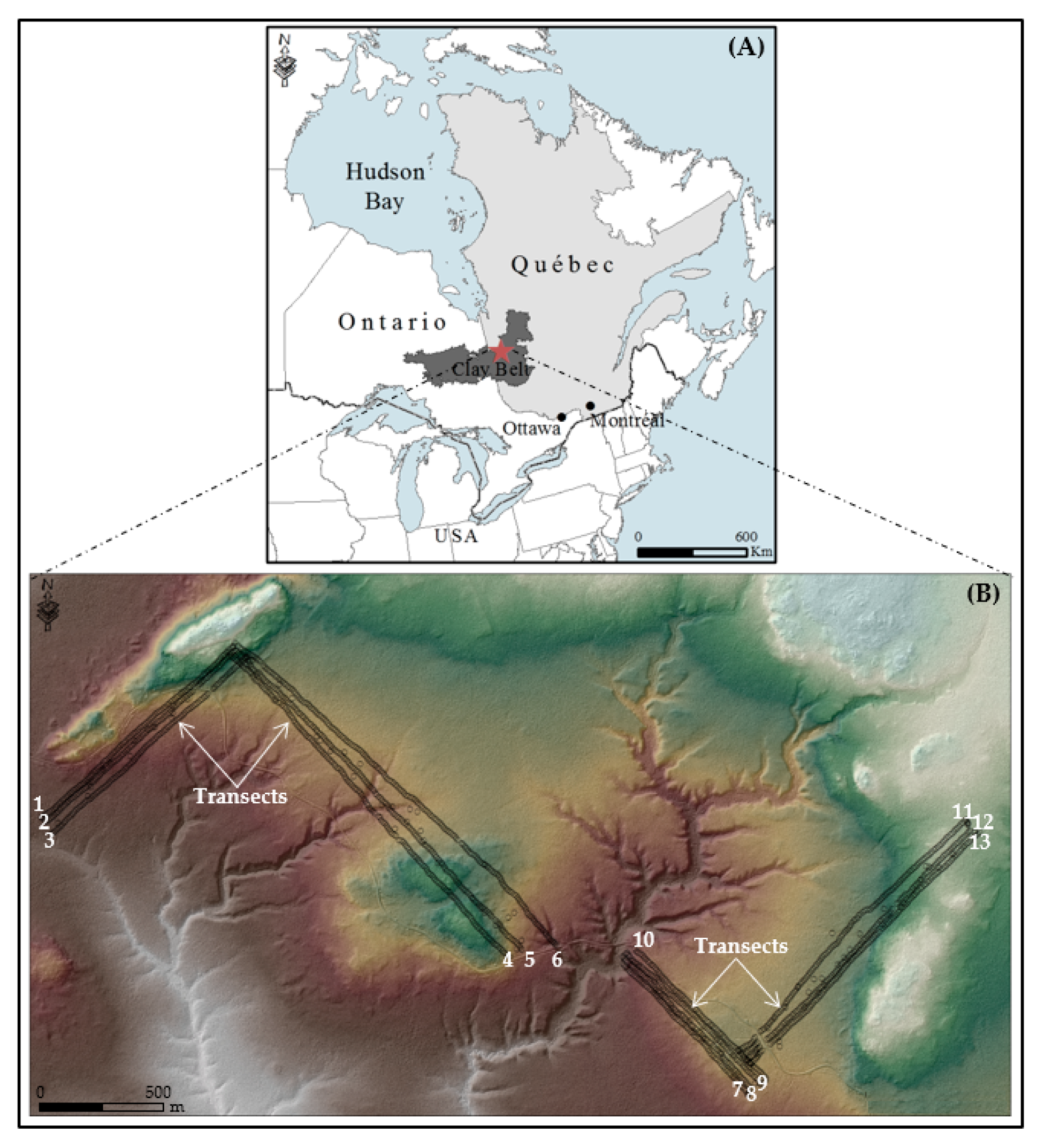
2.1. Study Area
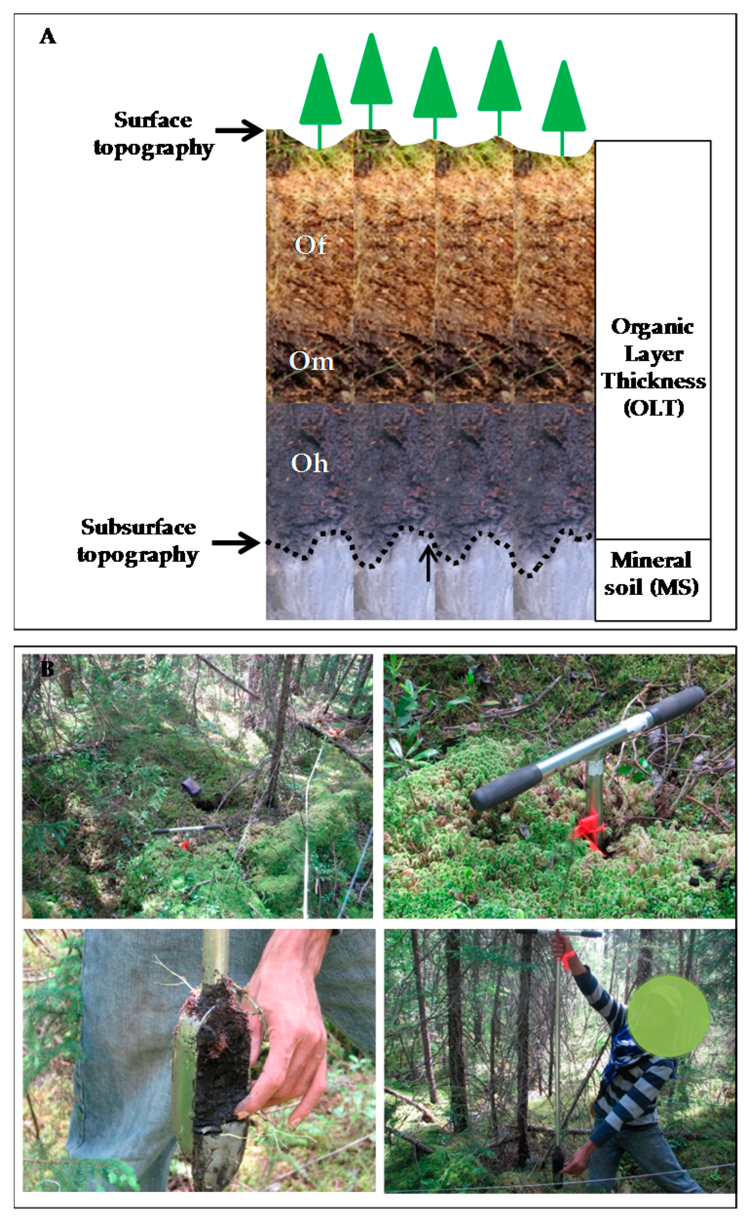
2.2. Sampling Design and Field Datasets Collection
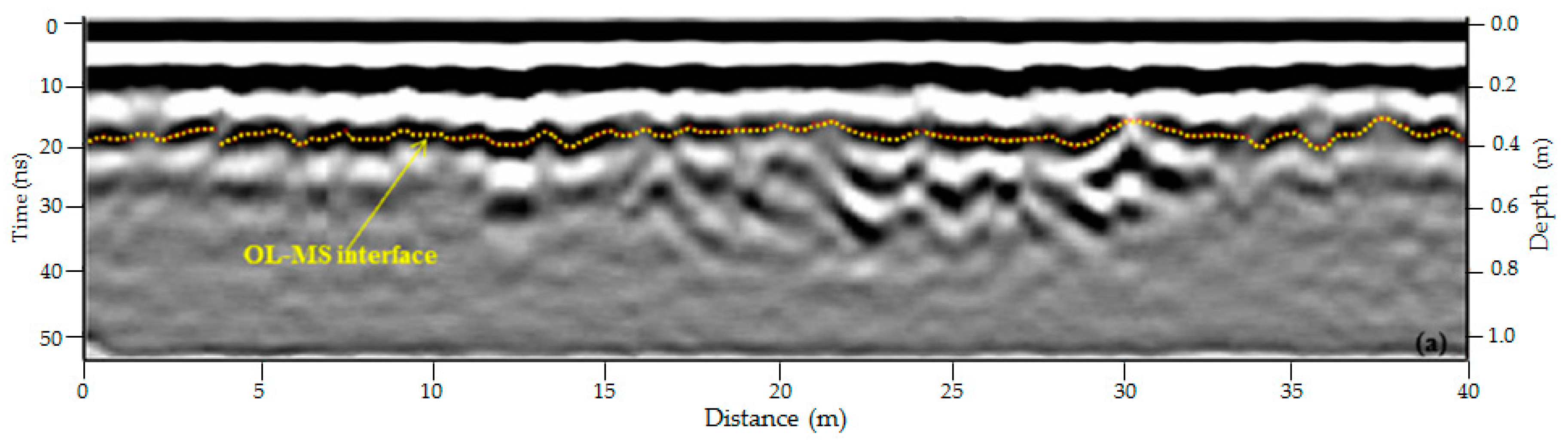
2.3. Mineral Layer Identification and Digital Mineral Soil Elevation Model Generation
2.4. Surface Digital Elevation Model Generation
2.5. Datasets Georeferencing Accuracy
2.6. Explanayory Topographic Variabled
2.7. Machine Learning Classification and Accuracy Assesment
3. Results
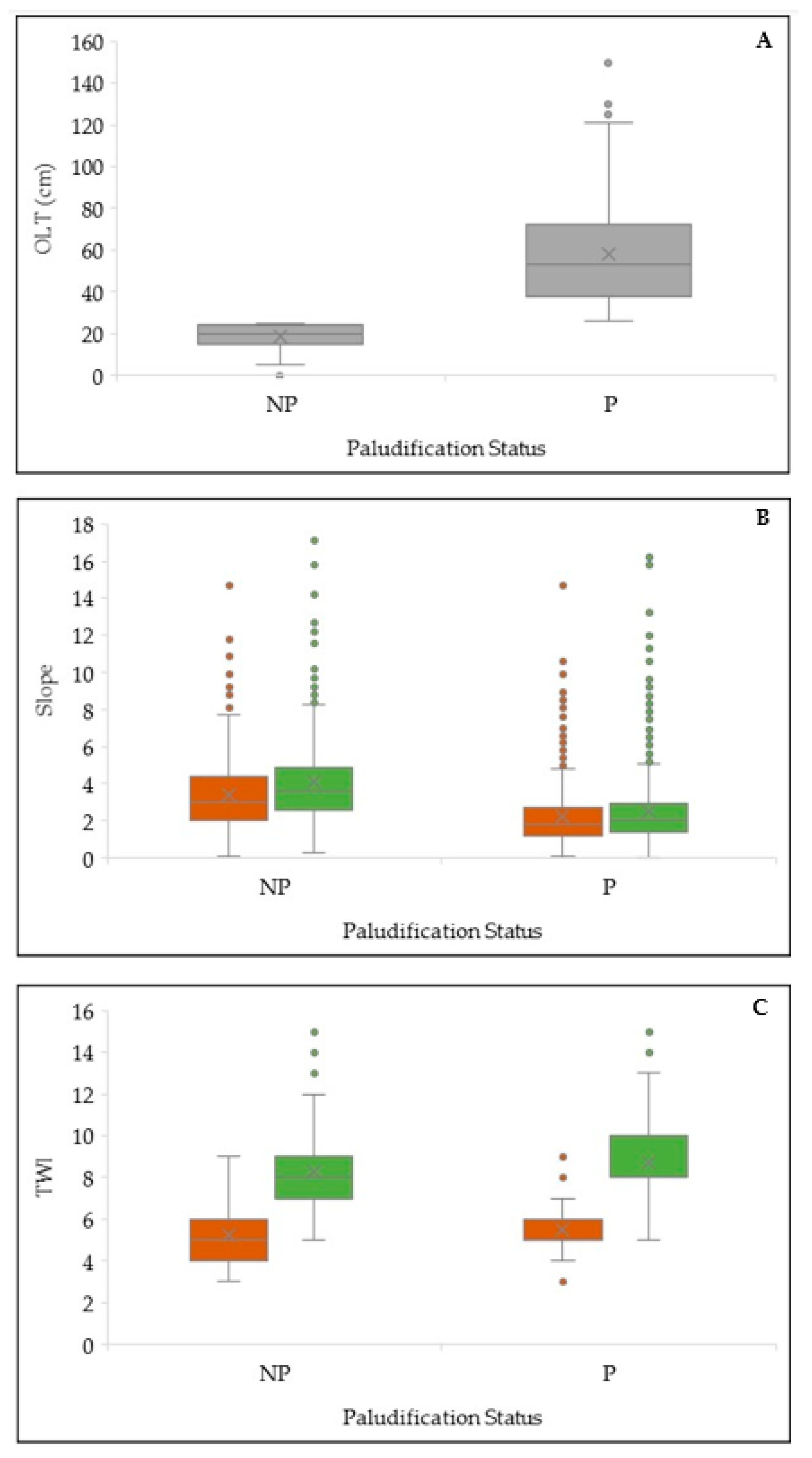
3.1. Results of OLT Class Distribution
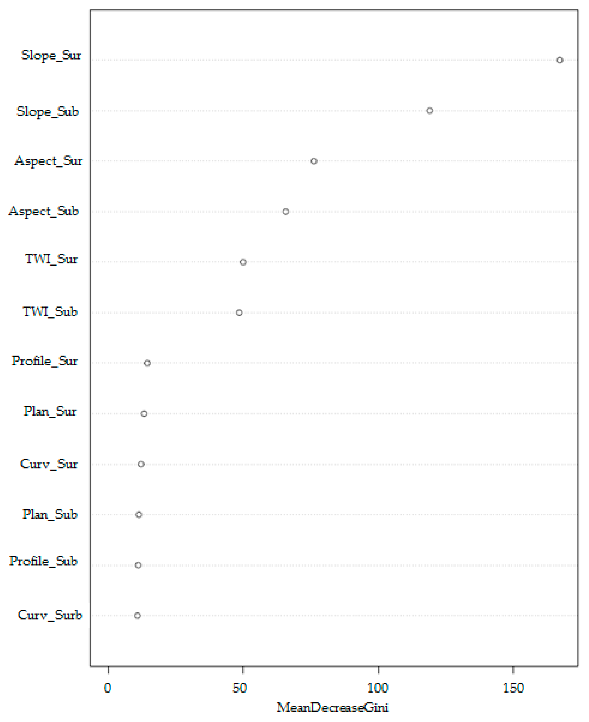
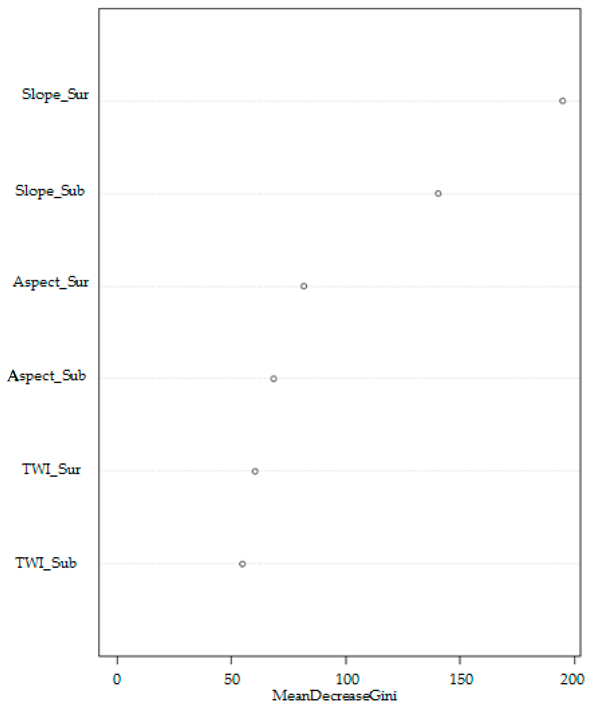
3.2. Results of Random Forest Modeling and Variable Importance
4. Discussion
5. Conclusions
Author Contributions
Funding
Acknowledgments
Conflicts of Interest
References
- Koubaa, A.; Isabel, N.; Zhang, S.Y.; Beaulieu, J.; Bousquet, J. Transition from juvenile to mature wood in black spruce (Picea mariana (Mill.) B.S.P.). Wood Fiber Sci. 2005, 37, 445–455. [Google Scholar]
- Crawford, R.M.M.; Jeffree, C.E.; Rees, W.G. Paludification and forest retreat in northern oceanic environments. Ann. Bot. 2003, 91, 213–226. [Google Scholar] [CrossRef] [Green Version]
- Vygodskaya, N.N.; Groisman, P.Y.; Tchebakova, N.M.; Kurbatova, J.A.; Panfyorov, O.; Parfenova, E.I.; Sogachev, A.F. Ecosystems and climate interactions in the boreal zone of northern Eurasia. Environ. Res. Lett. 2007, 2, 045033. [Google Scholar] [CrossRef]
- Fenton, N.; Lecomte, N.; Légaré, S.; Bergeron, Y. Paludification in black spruce (Picea mariana) forests of eastern Canada: Potential factors and management implications. For. Ecol. Manag. 2005, 213, 151–159. [Google Scholar] [CrossRef]
- Fenton, N.J.; Bergeron, Y. Sphagnum spore availability in boreal forests. Bryologist 2006, 109, 173–181. [Google Scholar] [CrossRef]
- Fenton, N.J.; Bergeron, Y. Sphagnum community change after partial harvest in black spruce boreal forests. For. Ecol. Manag. 2007, 242, 24–33. [Google Scholar] [CrossRef]
- Simard, M.; Bernier, P.Y.; Bergeron, Y.; Paré, D.; Guérine, L. Paludification dynamics in the boreal forest of the James Bay Lowlands: Effect of time since fire and topography. Can. J. For. Res. 2009, 39, 546–552. [Google Scholar] [CrossRef]
- Simard, M.; Lecomte, N.; Bergeron, Y.; Bernier, P.Y.; Paré, D. Forest productivity decline caused by successional paludification of boreal soils. Ecol. Appl. 2007, 17, 1619–1637. [Google Scholar] [CrossRef]
- Lavoie, M.; Paré, D.; Fenton, N.; Groot, A.; Taylor, K. Paludification and management of forested peatlands in Canada: A literature review. Environ. Rev. 2005, 13, 21–50. [Google Scholar] [CrossRef]
- Lecomte, N.; Simard, M.; Bergeron, Y.; Larouche, A.; Asnong, H.; Richard, P.J.H. Effects of fire severity and initial tree composition on understorey vegetation dynamics in a boreal landscape inferred from chronosequence and paleoecological data. J. Veg. Sci. 2005, 16, 665–674. [Google Scholar] [CrossRef]
- Laamrani, A.; Valeria, O.; Fenton, N.; Bergeron, Y. Landscape−scale influence of topography on organic layer accumulation in paludified boreal forests. For. Sci. 2014, 60, 579–590. [Google Scholar] [CrossRef]
- Hyyppä, J.; Hyyppä, H.; Leckie, D.; Gougeon, F.; Yu, X.; Maltamo, M. Review of methods of small-footprint airborne laser scanning for extracting forest inventory data in boreal forests. Int. J. Remote Sens. 2008, 29, 1339–1366. [Google Scholar] [CrossRef]
- Seibert, J.; Stendahl, J.; Sørensen, R. Topographical influences on soil properties in boreal forests. Geoderma 2007, 141, 139–148. [Google Scholar] [CrossRef]
- Laamrani, A.; Valeria, O.; Cheng, L.-Z.; Yves Bergeron, Y.; Camerlynck, C. The use of ground penetrating radar for remote sensing the organic layer–mineral soil interface in paludified boreal forests. Can. J. Remote Sens. 2013, 39, 74–88. [Google Scholar] [CrossRef]
- Laamrani, A.; Valeria, O.; Fenton, N.; Bergeron, Y.; Cheng, L.Z. The role of mineral soil topography on the spatial distribution of organic layer thickness in a paludified boreal landscape. Geoderma 2014, 221–222, 70–78. [Google Scholar] [CrossRef]
- Southee, F.M.; Treitz, P.M.; Scott, N.A. Application of LiDAR terrain surfaces for soil moisture modeling. Photogramm. Eng. Remote Sens. 2012, 78, 1241–1251. [Google Scholar] [CrossRef]
- Webster, K.L.; Creed, I.F.; Beall, F.D.; Bourbonniere, R.A. A topographic template for estimating soil carbon pools in forested catchments. Geoderma 2011, 160, 457–467. [Google Scholar] [CrossRef]
- Work, T.T.; St-Onge, B.; Jacobs, J.M. Response of female beetles to LIDAR derived topographic variables in Eastern boreal mixedwood forests (Coleoptera, Carabidae). ZooKeys 2011, 147, 623–639. [Google Scholar] [CrossRef] [Green Version]
- Laamrani, A.; Valeria, O.; Bergeron, Y.; Fenton, N.; Cheng, L.Z.; Kenneth, A. Effects of topography and thickness of organic layer on productivity of black spruce boreal forests of the Canadian Clay Belt region. For. Ecol. Manag. 2014, 330, 114–157. [Google Scholar] [CrossRef]
- Laamrani, A.; Valeria, O.; Bergeron, Y.; Fenton, N.; Cheng, L.Z. Distinguishing and mapping permanent and reversible paludified landscapes in Canadian black spruce forests. Geoderma 2015, 237–238. [Google Scholar] [CrossRef]
- Veillette, J.J. Evolution and paleohydrology of glacial Lakes Barlow and Ojibway. Quat. Sci. Rev. 1994, 13, 945–971. [Google Scholar] [CrossRef]
- Veillette, J.J.; Paradis, S.J.; Buckle, J. Bedrock and surficial geology of the general area around Rouyn-Noranda, Quebec and Ontario. In Metals in the environment around smelters: The GSC-MITE point sources project, Rouyn-Noranda (Quebec) and Belledune (New Brunswick). Bull. Geol. Surv. Can. 2005, 584, 1–16. [Google Scholar]
- Environment Canada. 1981–2010 Canadian Climate Normals: Joutel Weather Station, Province of Quebec. Available online: http://climate.weather.gc.ca/climate_normals/index_e.html#1981 (accessed on 3 December 2019).
- Peucker, T.K.; Fowler, R.J.; Little, J.J.; Mark, D.M. The triangulated irregular network. In Proceedings of the Digital Terrain Models (DTM) Symposium, St. Louis, MO, USA, 9–11 May 1978; American Society of Photogrammetry: Falls Church, VA, USA, 1978; pp. 516–540. [Google Scholar]
- ESRI. ArcGIS Desktop: Release 10. Environmental Systems Research Institute: Redlands, CA, USA, 2011. Available online: http://help.arcgis.com/en/arcgisdesktop/10.0/help/ (accessed on 3 December 2019).
- Blyth, E.M.; Finch, J.; Robinson, M.; Rosier, P. Can soil moisture be mapped onto the terrain? Hydrol. Earth Syst. Sci. 2004, 8, 923–930. [Google Scholar] [CrossRef] [Green Version]
- Güntner, A.; Seibert, J.; Uhlenbrook, S. Modeling spatial patterns of saturated areas: An evaluation of different terrain indices. Water Resour. Res. 2004, 40, W051141–W0511419. [Google Scholar] [CrossRef] [Green Version]
- Emili, L.A.; Price, J.S.; Fitzgerald, D.F. Hydrogeological influences on forest community type along forest—Peatland complexes in coastal British Columbia. Can. J. For. Res. 2006, 36, 2024–2037. [Google Scholar] [CrossRef] [Green Version]
- Moore, I.D.; Lewis, A.; Gallant, J.C. Terrain attributes: Estimation methods and scale effects. In Modeling Change in Environmental Systems; Jakeman, A.J., Beck, M.B., McAleer, M.J., Eds.; Wiley: London, UK, 1993; pp. 189–214. [Google Scholar]
- Beven, K.J.; Kirkby, M.J. A physically based, variable con-tributing area model of basin hydrology. Hydrol. Sci. Bull. 1979, 24, 43–69. [Google Scholar] [CrossRef] [Green Version]
- Sørensen, R.; Zinko, U.; Seibert, J. On the calculation of the topographic wetness index: Evaluation ofdifferent methods based on field observations. Hydrol. Earth Syst. Sci. 2006, 10, 101–112. [Google Scholar] [CrossRef] [Green Version]
- Breiman, L. Random forests. Mach. Learn. 2001, 45, 5–32. [Google Scholar] [CrossRef] [Green Version]
- Siroky, D.S. Navigating Random Forests and related advances in algorithmic modeling. Stat. Surv. 2009, 3, 147–163. [Google Scholar] [CrossRef] [Green Version]
- Dormann, C.F.; Elith, J.; Bacher, S.; Buchmann, C.; Carl, G.; Carré, G.; Marquéz, J.R.G.; Gruber, B.; Lafourcade, B.; Leitão, P.J.; et al. Collinearity: A review of methods to deal with it and a simulation study evaluating their performance. Ecography 2013, 36, 027–046. [Google Scholar] [CrossRef]
- Lafleur, B.; Fenton, N.J.; Simard, M.; Leduc, A.; Paré, D.; Valeria, O.; Bergeron, Y. Ecosystem management in paludified boreal forests: Enhancing wood production, biodiversity, and carbon sequestration at the landscape level. For. Ecosyst. 2018, 5, 27. [Google Scholar] [CrossRef] [Green Version]
- Henneb, M.; Valeria, O.; Fenton, N.J.; Thiffault, N.; Bergeron, Y. Mechanical site preparation: Key to microsite creation success on Clay Belt paludified sites. For. Chron. 2015, 91, 187–196. [Google Scholar] [CrossRef] [Green Version]


| Topographic Variables | Description |
|---|---|
| Slope | Calculated for each grid cell as the maximum rate of change in z-value from that cell to its neighbors. Slope affects the overall rate of movement downslope. |
| Aspect | Direction of the maximum rate of change in the z-value from each cell to its neighbors. Aspect defines the direction of flow and was classified into eight major classes (i.e., N, NE, E, SE, S, SW, W, NW). |
| Mean curvature | A general measure of the convexity of the landscape, where negative values represent sinks and valleys are considered to be concave, and positive values are associated with peaks and highs are considered to be convex. |
| Plan curvature | Curvature of the surface perpendicular to the slope direction. Positive values indicate that water flow would diverge (convex surface), whereas negative values indicate that water flow would converge (concave surface). |
| Profile curvature | Curvature of the surface in the direction of a slope. Positive values indicate that water flow would decelerate (concave surface), whereas a negative value will indicate that water flow would accelerate (convex surface). |
| Topographic wetness index (TWI) | TWI = ln (As/tan β) (Eq. in [28]) where As is the local upslope contributing area and β is the local slope [29,30,31]. The higher the value of the TWI in a cell, the higher the soil moisture and water accumulation that can be found on it. |
| Class | n | OLT (cm) | ||
|---|---|---|---|---|
| Min | Max | Mean ± SE | ||
| non-paludified | 456 | 5 | 25 | 19 ± 0.2 |
| paludified | 1158 | 26 | 150 | 58 ± 0.7 |
| All data | 1614 | 5 | 150 | 47 ± 0.7 |
© 2020 by the authors. Licensee MDPI, Basel, Switzerland. This article is an open access article distributed under the terms and conditions of the Creative Commons Attribution (CC BY) license (http://creativecommons.org/licenses/by/4.0/).
Share and Cite
Laamrani, A.; Valeria, O. Ranking Importance of Topographical Surface and Subsurface Parameters on Paludification in Northern Boreal Forests Using Very High Resolution Remotely Sensed Datasets. Sustainability 2020, 12, 577. https://doi.org/10.3390/su12020577
Laamrani A, Valeria O. Ranking Importance of Topographical Surface and Subsurface Parameters on Paludification in Northern Boreal Forests Using Very High Resolution Remotely Sensed Datasets. Sustainability. 2020; 12(2):577. https://doi.org/10.3390/su12020577
Chicago/Turabian StyleLaamrani, Ahmed, and Osvaldo Valeria. 2020. "Ranking Importance of Topographical Surface and Subsurface Parameters on Paludification in Northern Boreal Forests Using Very High Resolution Remotely Sensed Datasets" Sustainability 12, no. 2: 577. https://doi.org/10.3390/su12020577
APA StyleLaamrani, A., & Valeria, O. (2020). Ranking Importance of Topographical Surface and Subsurface Parameters on Paludification in Northern Boreal Forests Using Very High Resolution Remotely Sensed Datasets. Sustainability, 12(2), 577. https://doi.org/10.3390/su12020577